Weather officials have announced a heat advisory that went into effect Sunday afternoon at 2:25 PM and will remain in place until Monday evening at 8:00 PM.
The advisory was issued by the National Weather Service Mount Holly office, alerting residents to prepare for dangerous heat conditions during this timeframe.
Residents are advised to take appropriate safety measures during the advisory period, including staying hydrated and limiting outdoor activities during peak heat hours.
A cold front will move through the region Wednesday into Thursday, bringing showers and thunderstorms followed by a noticeable drop in temperatures by the end of the week.
The front is expected to arrive during the second half of Wednesday and continue through Wednesday night. Ahead of the front, a warm and unstable air mass will remain in place, helping to fuel the development of thunderstorms. While the strongest forcing and wind shear may remain farther north, the environment should still be supportive of some organized storms.
Because of this setup, there is a risk for isolated strong to severe thunderstorms on Wednesday. The Storm Prediction Center has maintained a Marginal Risk for severe weather, which means a few storms could become strong enough to produce damaging wind gusts and large hail.
Rainfall totals from this system are generally expected to stay around a quarter inch or less for many areas. However, any stronger thunderstorms could produce locally higher rainfall amounts, especially with atmospheric moisture levels running fairly high. Some storms may be capable of producing brief heavy downpours.
By Thursday morning, the cold front is expected to settle south of the region, but it may linger nearby through the rest of the day. This could keep scattered showers in the forecast, especially across southeastern areas.
Behind the front, temperatures will turn much cooler by late week, ending the stretch of above normal warmth. The overall pattern looks unsettled heading into Friday and the weekend, with additional chances for showers possible.
Weather officials have issued a heat advisory that went into effect early Sunday morning and will remain in place through Monday evening.
The National Weather Service office in Mount Holly, New Jersey issued the advisory at 3:26 a.m. on May 19th, with the warning period extending until 8:00 p.m. on May 20th.
During a heat advisory, residents are encouraged to take extra precautions when spending time outdoors, stay hydrated, and check on elderly neighbors and relatives who may be more vulnerable to heat-related illness.
A rapidly expanding wildfire broke out Monday morning in Southern California, forcing residents from their homes and destroying at least one house.
The blaze began shortly after 10 a.m. in Simi Valley, located in Ventura County approximately 30 miles northwest of Los Angeles.
By just before noon, the fire had consumed more than 180 acres, said Scott Dettorre, spokesperson for the Ventura County Fire Department.
Television news helicopters captured images showing at least one residence engulfed in flames. Fire officials have not released specific numbers on property damage. Several helicopters were observed making water drops on the burning area while thick gray smoke covered the surrounding community.
Evacuation orders were issued for residents living in Simi Valley’s southern section. The city is home to more than 125,000 people.
Emergency responders worked urgently to prevent the fire from advancing down hillsides into residential areas of Thousand Oaks.
The National Weather Service issued an advisory for the region warning of winds between 20 and 30 mph lasting until 3 p.m.
A Code Orange Air Quality Action Day has been issued for all of Delaware on Tuesday, May 19, as dangerous heat and stagnant atmospheric conditions are expected to lead to elevated ozone levels across the state.
According to the Delaware Department of Natural Resources and Environmental Control (DNREC), air quality levels are forecast to reach “Unhealthy for Sensitive Groups” for ozone pollution, especially during the afternoon and early evening hours. Fine particulate matter, or PM2.5, is expected to remain in the low-Moderate category.
The combination of several meteorological factors is expected to contribute to deteriorating air quality. A temperature inversion early Tuesday morning will trap pollutants near the ground, limiting vertical mixing in the atmosphere. At the same time, light to moderate southwesterly to westerly winds will transport additional regional pollution into Delaware from upwind areas.
Adding to the concern, mostly sunny skies and temperatures soaring into the middle 90s will enhance ozone production throughout the day. Ozone pollution tends to peak during hot, sunny weather when emissions from vehicles, industry, and other sources chemically react in the atmosphere.
Sensitive groups, including children, older adults, and individuals with asthma or other respiratory conditions, are encouraged to limit prolonged outdoor activity during the afternoon and evening hours when ozone concentrations are typically highest.
Conditions may remain somewhat elevated into Wednesday as another hot day with temperatures in the mid-90s is expected across southern Delaware. Continued west-southwesterly flow will keep transporting pollutants into the region, while sunny skies will support additional ozone development. Air quality levels are forecast to remain in the Moderate range statewide.
Relief is expected to arrive Thursday as a cold front moves offshore. Northeasterly winds behind the front will usher in a cooler and cleaner air mass into the Mid-Atlantic. Increasing cloud cover and scattered rain showers are also expected to suppress ozone formation, allowing air quality levels to improve back into the Good category for both ozone and PM2.5 across Delaware.
Weather authorities have issued a heat advisory that will remain in effect from Saturday afternoon through Monday evening.
The National Weather Service Mount Holly New Jersey office announced the advisory on May 18 at 2:10 PM EDT, with the warning period extending until May 20 at 8:00 PM EDT.
Residents should prepare for elevated temperatures during this multi-day period and take appropriate precautions to stay safe in the hot conditions.
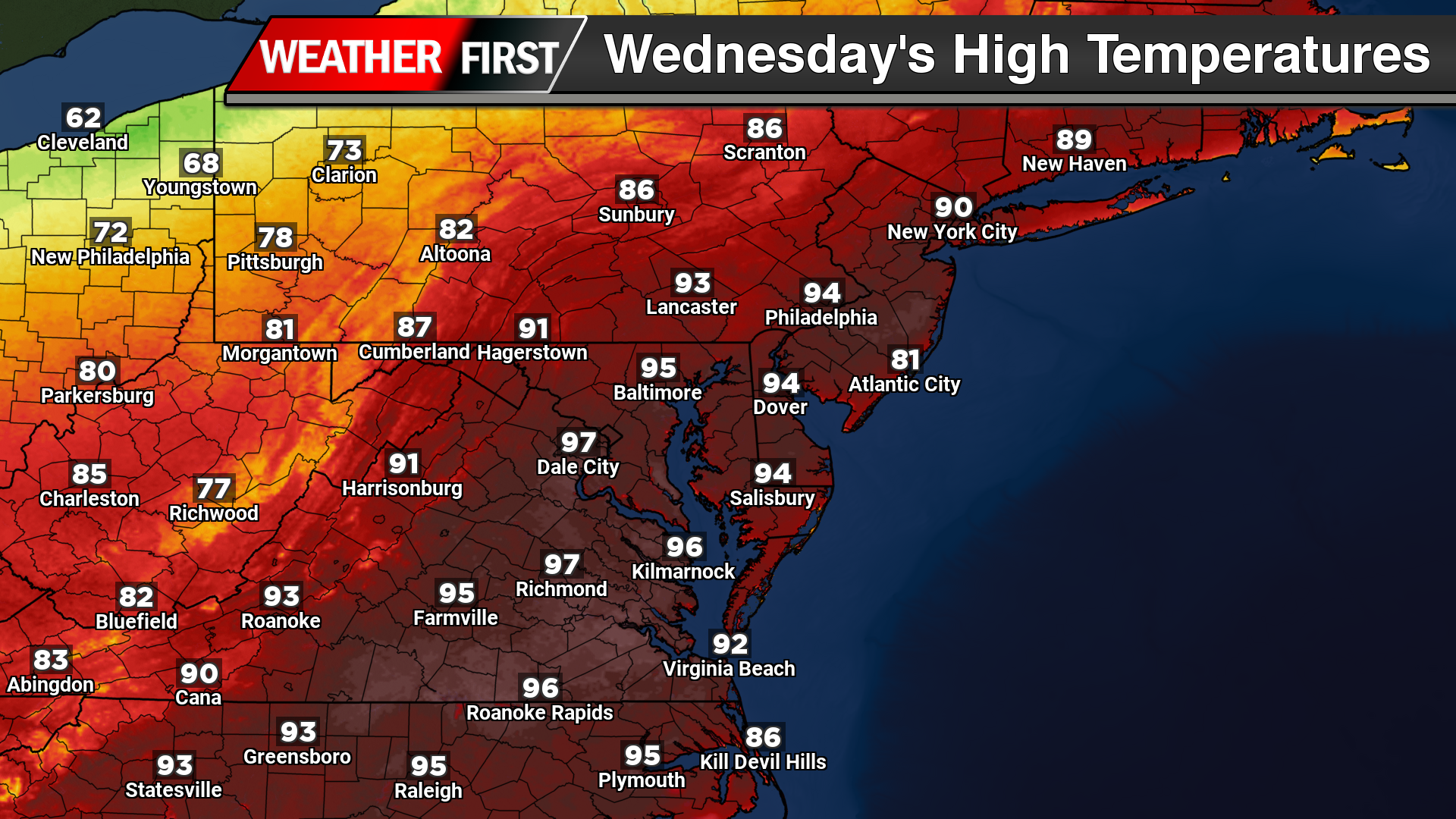
A stretch of unusually intense early season heat is expected to grip the Delmarva Peninsula and much of the Mid Atlantic through Wednesday, with temperatures running 10 to 20 degrees above average for mid May. Several locations could challenge daily and even monthly record highs as a strong upper level ridge and offshore Bermuda high pressure combine to deliver a prolonged period of summer-like warmth.
High temperatures across inland portions of Delaware, Maryland’s Eastern Shore, and surrounding inland areas are expected to climb into the upper 80s to middle 90s each afternoon through Wednesday. Tuesday currently appears to be the hottest day of the stretch, with widespread mid 90s anticipated across much of the region. Overnight temperatures will also remain exceptionally warm for this time of year, only falling into the mid 60s to lower 70s, which could challenge warm minimum temperature records for May 19th.
The pattern responsible for the heat features a large dome of high pressure in the upper atmosphere anchored over the East Coast through Tuesday before gradually weakening and shifting offshore Wednesday. At the surface, Bermuda high pressure positioned offshore is maintaining a persistent southerly to southwesterly flow, transporting much warmer air northward into the region.
While inland communities are expected to experience the most intense heat, coastal locations will see somewhat cooler conditions due to the influence of the Atlantic Ocean and developing sea breezes. Areas closer to the Delaware beaches and immediate coastline may remain in the 70s to middle 80s during the afternoon before temperatures gradually cool later in the day as marine air pushes inland.
Humidity levels are not expected to become excessively tropical, but dewpoints in the low to middle 60s will still create uncomfortable conditions given the lack of recent heat acclimation. Heat index values are forecast to remain close to actual air temperatures, meaning many inland areas will feel well into the 90s during the afternoon hours.
Heat Advisories have been issued for portions of the urban corridor as temperatures and heat indices approach early season warning criteria. Wilmington and parts of New Castle County may avoid the most intense heat at times due to cooling bay breeze influences.
The weather pattern will remain mostly dry through Tuesday with abundant sunshine and only a very isolated chance for a late day shower or thunderstorm well inland. By Wednesday, an approaching cold front may begin to introduce additional cloud cover and scattered showers or thunderstorms, which could slightly limit how hot temperatures become. Even so, temperatures are still expected to remain well above normal and near record territory, especially southeast of the Interstate 95 corridor where sunshine may persist longest.
Relief from the heat is expected to arrive late Wednesday into Thursday as the cold front moves through the region. Temperatures should gradually return closer to seasonal averages heading into the latter half of the week and next weekend.
Coastal communities may face a challenging weather combination as El Niño conditions coincide with high tide flooding events, creating what experts describe as a potential ‘double whammy’ scenario.
The convergence of these two separate weather phenomena could lead to more significant flooding impacts than communities would typically experience from either condition occurring independently.
High tide flooding, also known as nuisance flooding, occurs when ocean water levels rise during regular tidal cycles, often inundating low-lying coastal areas, roads, and infrastructure even without storm activity.
When combined with El Niño weather patterns, which can influence precipitation and storm intensity, the flooding risks for vulnerable coastal areas may be amplified beyond normal seasonal expectations.
Weather forecasters and emergency management officials are monitoring these conditions closely as they develop, particularly in areas that have experienced recurring flooding challenges during previous high tide events.
The timing and severity of these combined impacts will depend on various factors including local geography, existing infrastructure, and the specific intensity of both the El Niño pattern and tidal conditions as they evolve.
SMYRNA, Del. – As Delaware prepares for the 2026 hurricane season running from June 1st through November 30th, Governor Matt Meyer has designated May 18th through May 22nd as Hurricane Preparedness Week.
The Delaware Emergency Management Agency (DEMA) is working alongside state, county and local agencies to encourage residents to make preparations before the season begins. Officials are promoting advance planning as the best defense against potential storm impacts.
Weather forecasters are predicting below normal storm activity for the 2026 hurricane season, though emergency officials stress that residents should still take preparedness seriously regardless of seasonal predictions.
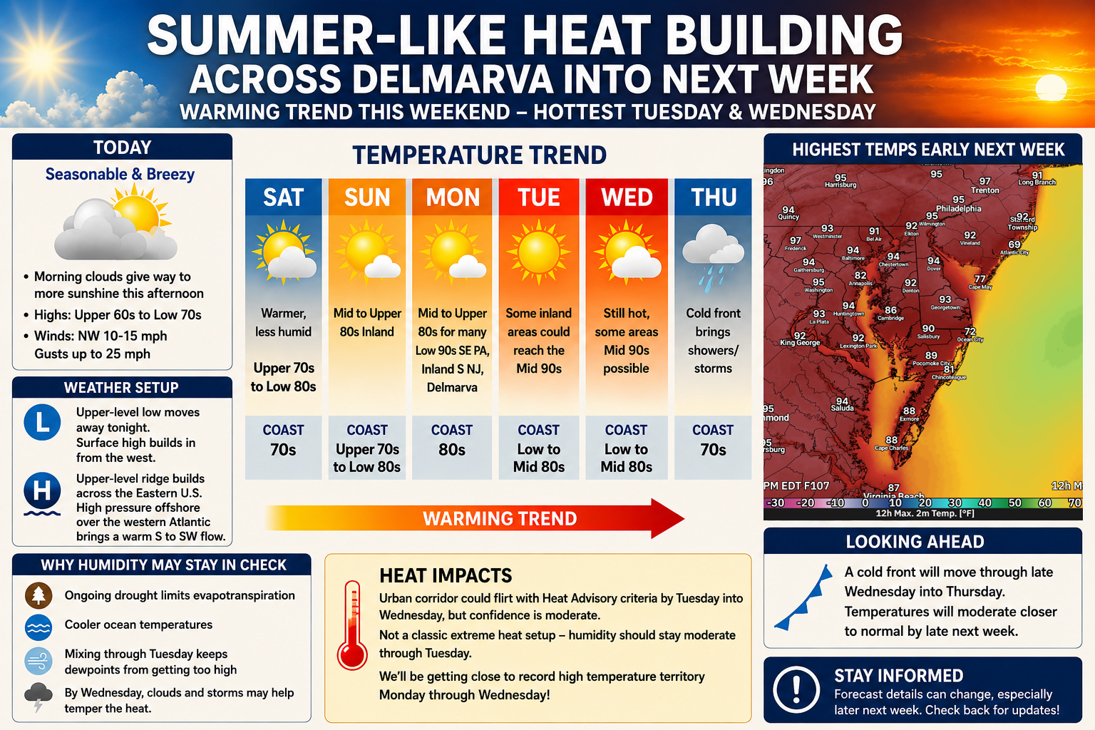
After a stretch of seasonable and breezy conditions to close out the workweek, a significant warm up is on the way for the Delmarva region as an expanding ridge of high pressure ushers in the first widespread taste of summer-like heat heading into next week.
Clouds will linger through much of today as an upper-level low pressure system slowly pulls away from the Mid-Atlantic. However, increasing sunshine is expected later this afternoon as surface high pressure begins to build into the region. Temperatures today will remain relatively comfortable for mid-May standards, with highs generally ranging from the upper 60s to lower 70s accompanied by northwest winds of 10 to 15 mph and gusts up to 25 mph.
The overall weather pattern will undergo a major transition this weekend as a strong upper-level ridge strengthens across the eastern United States. At the same time, high pressure anchored offshore over the western Atlantic will establish a persistent south to southwesterly flow across the Mid-Atlantic and Delmarva Peninsula. This setup will allow progressively warmer air to surge northward through at least the middle of next week.
Temperatures Saturday will begin climbing back above normal with highs reaching the upper 70s to lower 80s inland, though coastal communities will remain several degrees cooler thanks to the influence of chilly ocean waters.
By Sunday, much of inland Delmarva could rise into the mid to upper 80s while beach areas remain closer to the upper 70s or lower 80s. The warming trend intensifies further Monday as many communities across Delmarva push into the upper 80s to lower 90s.
Forecast guidance suggests Tuesday and potentially Wednesday may bring the hottest temperatures of the stretch. Some inland areas across Delmarva, southern New Jersey, and eastern Pennsylvania could climb into the middle 90s if sunshine remains dominant. Confidence in exact temperatures later next week remains somewhat lower, especially as clouds and possible thunderstorms approach with an eventual cold front.
Despite the increasing heat, forecasters note this setup currently does not appear especially favorable for oppressive humidity levels. Dry ground conditions associated with ongoing drought concerns across parts of the Mid-Atlantic may limit evapotranspiration, while cooler ocean temperatures should also help prevent excessive moisture from building into the atmosphere early in the week. As a result, while temperatures may approach heat advisory territory in some urban areas by Tuesday or Wednesday, the overall heat index values may remain somewhat lower than typical midsummer heat waves.
Even so, several locations could flirt with daily record high temperatures between Monday and Wednesday as this early-season heat intensifies across the region.
Relief is expected by late next week as a cold front moves through the Mid-Atlantic sometime Wednesday into Thursday, bringing temperatures back closer to seasonal averages along with the potential for scattered showers and thunderstorms.
Hurricane season monitoring has officially commenced for 2026, with the National Hurricane Center in Miami beginning its regular Atlantic basin weather assessments on Friday, May 15.
Weather forecasters report that no tropical storm or hurricane formation is anticipated during the upcoming seven-day period across the North Atlantic, Caribbean Sea, and Gulf of America regions.
The federal weather service will now provide these tropical weather assessments daily through November 30, offering updates on any significant weather disturbances and their likelihood of developing into tropical systems. These reports are released four times daily at 2 AM, 8 AM, 2 PM, and 8 PM Eastern Daylight Time.
When daylight saving time ends in November, the schedule shifts to 1 AM, 7 AM, 1 PM, and 7 PM Eastern Standard Time. Emergency updates will be distributed between regular reporting times when weather conditions warrant additional alerts.
Residents can access visual versions of these tropical weather assessments online at hurricanes.gov for the latest storm tracking information and forecasts.
Delaware transportation officials have temporarily shut down a section of Airport Road due to flooding over Nonesuch Creek.
The Delaware Department of Transportation reports the roadway is currently impassable at the creek crossing and will remain closed until water conditions improve.
Motorists are advised to seek alternate routes while crews monitor the situation.
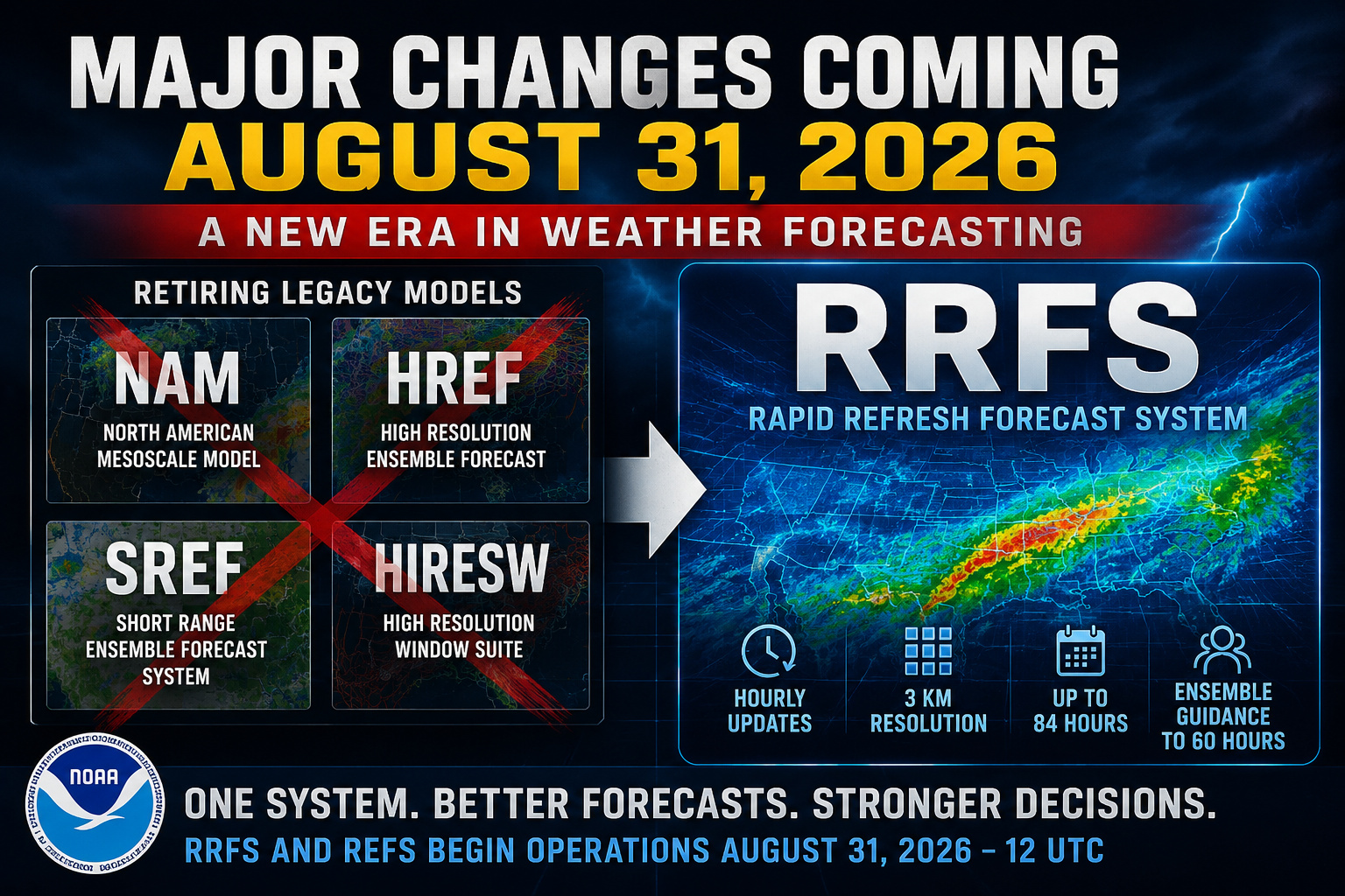
Major changes are coming to the world of weather forecasting later this year, as the National Weather Service and NOAA prepare to retire several long standing forecast models on August 31, 2026, replacing them with a new generation forecasting system known as the Rapid Refresh Forecast System, or RRFS.
According to newly released NOAA Service Change Notices, the RRFS and its ensemble counterpart, the RRFS Ensemble Forecast System (REFS), will officially become operational beginning with the 12 UTC model cycle on August 31st. The transition marks one of the largest overhauls to the National Weather Service’s regional forecasting guidance suite in decades.
The changes will retire several legacy forecasting systems that meteorologists, broadcasters, emergency managers, and weather enthusiasts have relied on for years. Models scheduled for retirement include the North American Mesoscale Model (NAM), the High Resolution Ensemble Forecast (HREF), the Short Range Ensemble Forecast system (SREF), and much of the High Resolution Window guidance suite (HiresW).
The RRFS is designed to unify many of these forecasting systems into one high resolution platform capable of producing hourly updated forecasts across North America at 3 kilometer resolution. NOAA says the new system will simplify the nation’s convective scale guidance while improving consistency between forecast products.
The deterministic version of the RRFS will run hourly, with extended forecasts reaching out to 84 hours during the primary 00z, 06z, 12z, and 18z model cycles. Additional hourly updates will extend to 18 hours. Meanwhile, the REFS ensemble system will provide probabilistic guidance out to 60 hours, replacing the HREF system currently used heavily during severe weather and winter storm forecasting.
One notable aspect of the transition is that NOAA plans to eventually phase out additional models, including the widely used RAP and HRRR systems, as future versions of the RRFS mature. While the HRRR is not being retired on August 31st, NOAA researchers have stated the long term goal is for the RRFS framework to ultimately replace legacy regional convection allowing models entirely.
The move has generated mixed reactions within the meteorological community. Some meteorologists welcome the modernization and unified approach, while others remain cautious about the RRFS performance during severe weather events. Discussions across weather forums and meteorology communities have highlighted concerns regarding convective feedback and supercell handling in earlier experimental RRFS versions.
NOAA says the RRFS has undergone extensive testing through multiple national forecast testbeds and collaborative evaluations involving federal agencies, universities, and meteorological partners across the country. Experimental real time data feeds for the RRFS and REFS are expected to become publicly available around June 9th ahead of full operational implementation later this summer.
For operational meteorologists and weather enthusiasts alike, August 31st will mark the beginning of a major shift in how short range weather forecasting is performed across the United States.
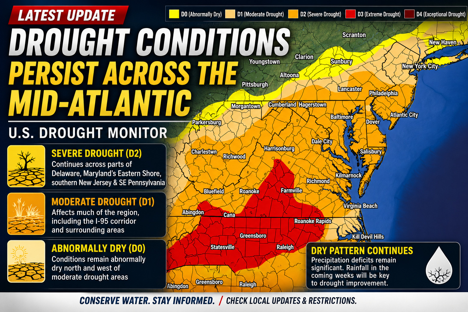
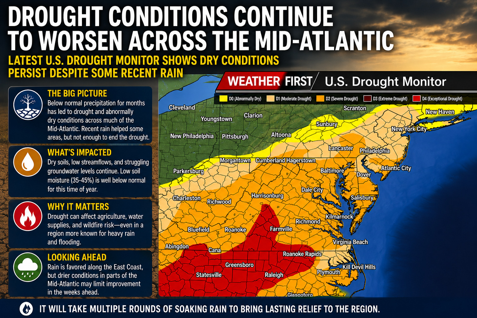
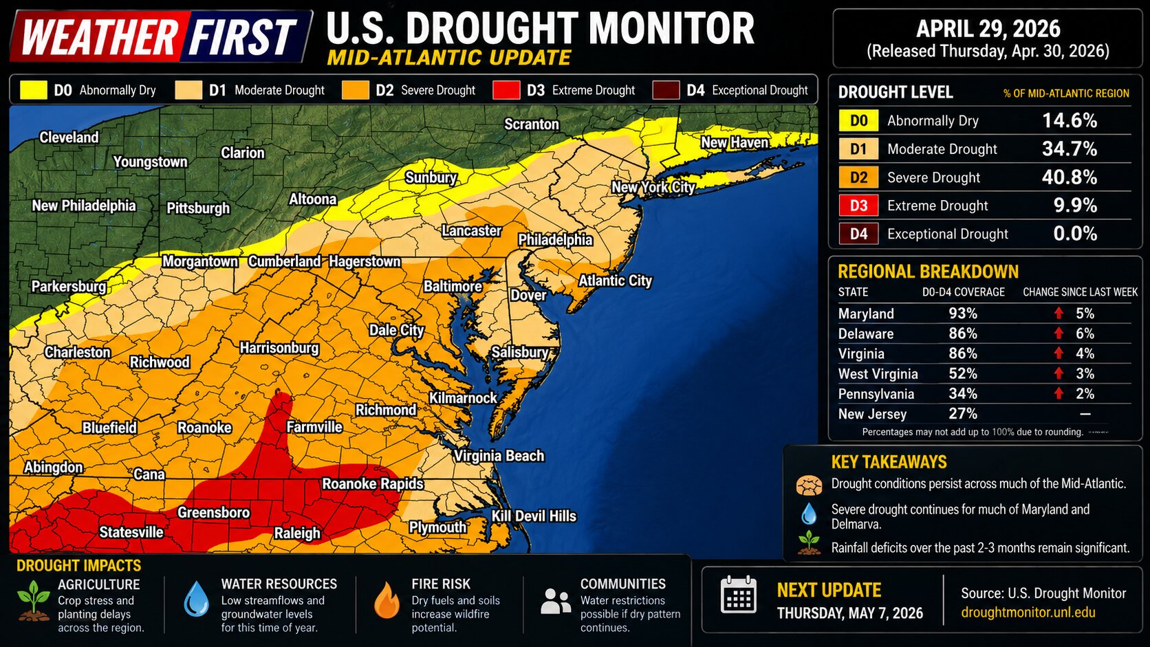
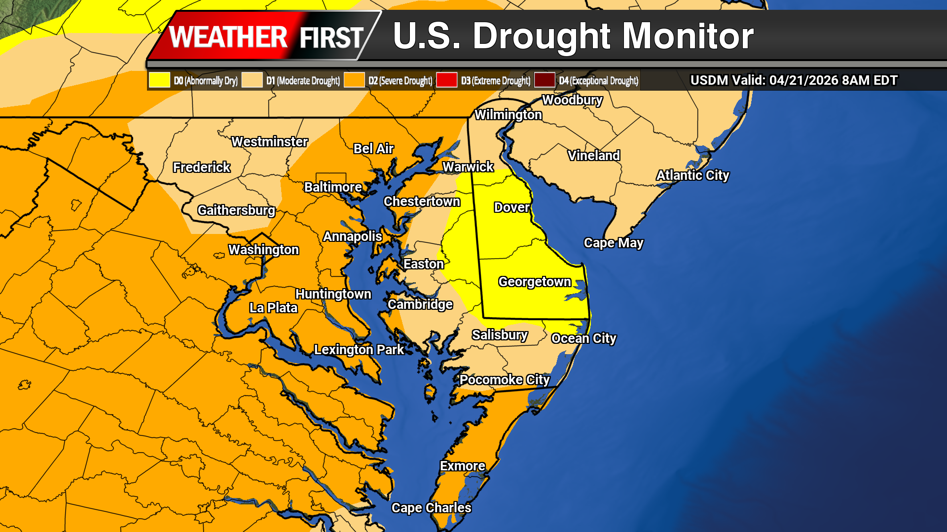
The latest update from the U.S. Drought Monitor shows drought conditions continuing across portions of the Mid-Atlantic region, including parts of Maryland’s Eastern Shore, Delaware, New Jersey, and southeastern Pennsylvania, as long-term precipitation deficits continue to impact groundwater, streamflows, and agriculture.
According to the latest drought information statement issued by the National Weather Service Philadelphia/Mount Holly, severe drought conditions, classified as D2 on the U.S. Drought Monitor scale, remain in place across portions of the region. Moderate drought, or D1 conditions, continue across much of the forecast area, while abnormally dry conditions persist elsewhere.
The Delmarva Peninsula continues to be one of the more concerning areas in the region. The drought statement noted that drought conditions worsened across portions of Delmarva over the past several weeks with little improvement observed. Maryland has continued its Drought Warning for counties along the Maryland Eastern Shore, while drought watches and warnings also remain in effect for parts of southeastern Pennsylvania and all of New Jersey.
In Delaware, ongoing dry conditions continue to take a toll on hydrologic conditions statewide. The University of Delaware Climate Office reported that the state has experienced eight consecutive months of below-normal precipitation, leading to rainfall deficits exceeding 11 inches since late summer of last year. Streamflows across portions of the state have dropped to some of the lowest levels ever recorded for this time of year, while groundwater recovery remains sluggish after consecutive dry seasons.
The broader Mid-Atlantic region has experienced one of its more significant drought episodes in recent decades. The National Integrated Drought Information System noted that the 2024-2025 drought became one of the worst drought periods seen in parts of the Mid-Atlantic in more than two decades, impacting agriculture, water resources, ecosystems, and increasing wildfire concerns.
Recent rounds of rainfall have provided some temporary relief in isolated areas, but precipitation deficits remain substantial overall. Seven-day average streamflows across much of the Mid-Atlantic continue running below normal, and reservoir levels remain below seasonal averages in several locations.
Looking ahead, we expect periods of rainfall over the coming week, though it remains uncertain whether enough widespread precipitation will occur to significantly improve long-term drought conditions. Warmer temperatures expected heading deeper into late spring and early summer could also increase evaporation rates and further stress soil moisture across the region.
Motorists traveling on I-495 will need to slow down as transportation authorities have implemented a temporary speed reduction due to current weather conditions.
The speed limit along the highway has been lowered to 55 miles per hour as rain creates potentially dangerous driving conditions for commuters and travelers.
Officials made the decision to reduce speeds as a precautionary safety measure while wet weather persists in the area. Drivers are advised to exercise additional caution and maintain appropriate following distances while the temporary speed restriction remains in effect.
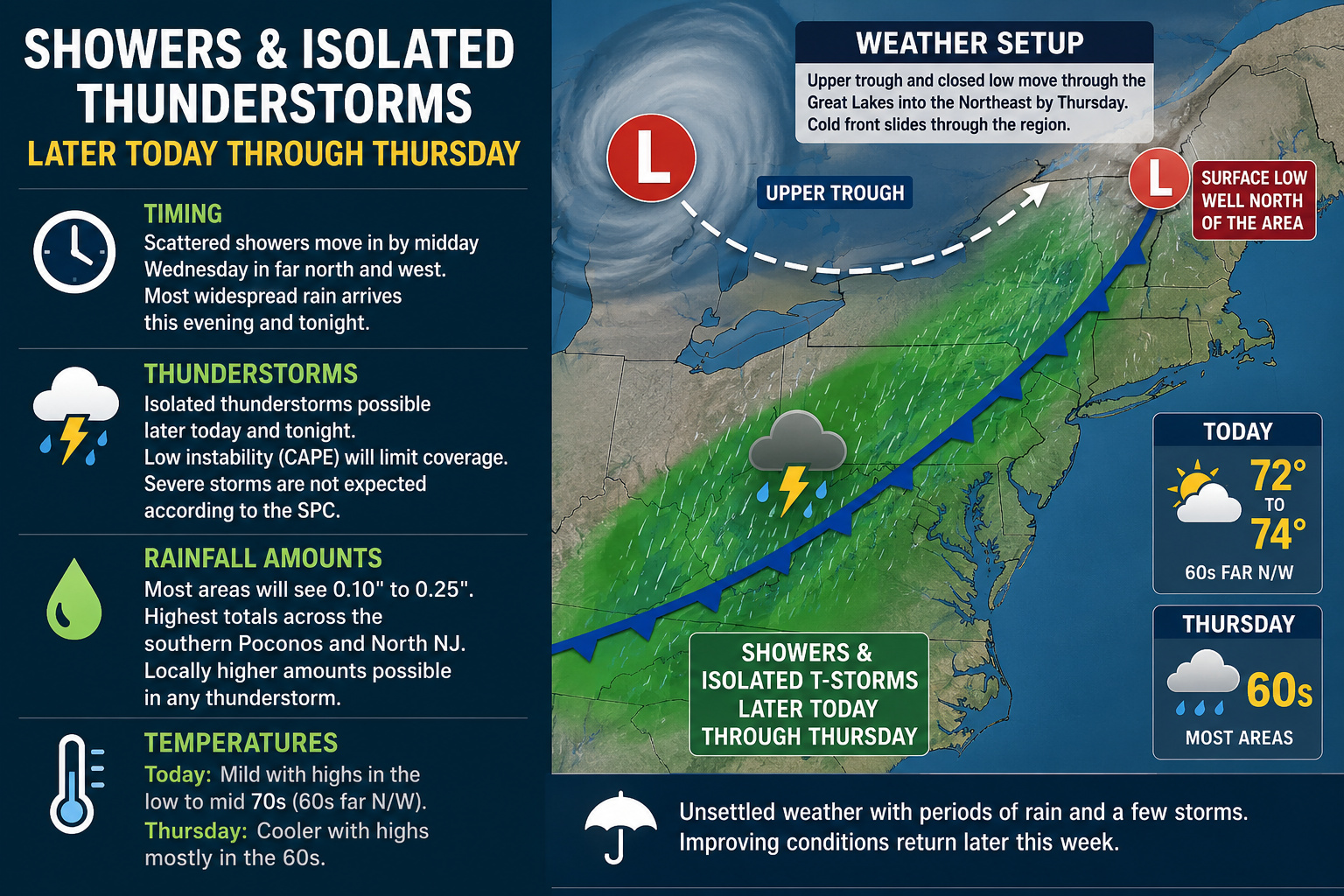
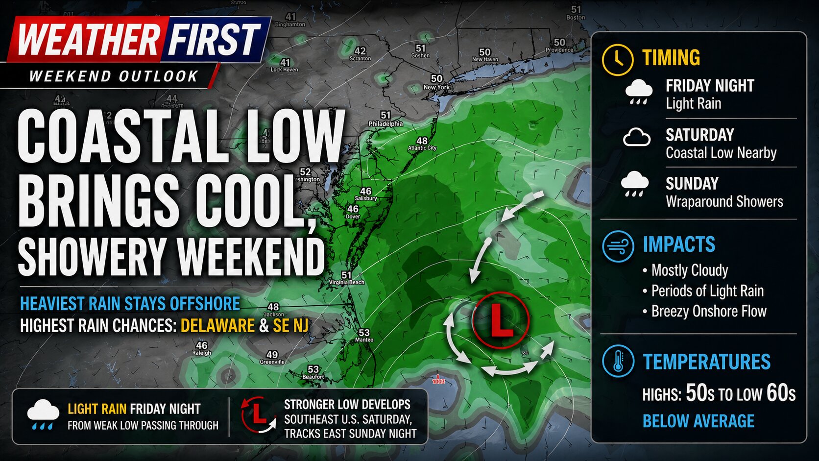
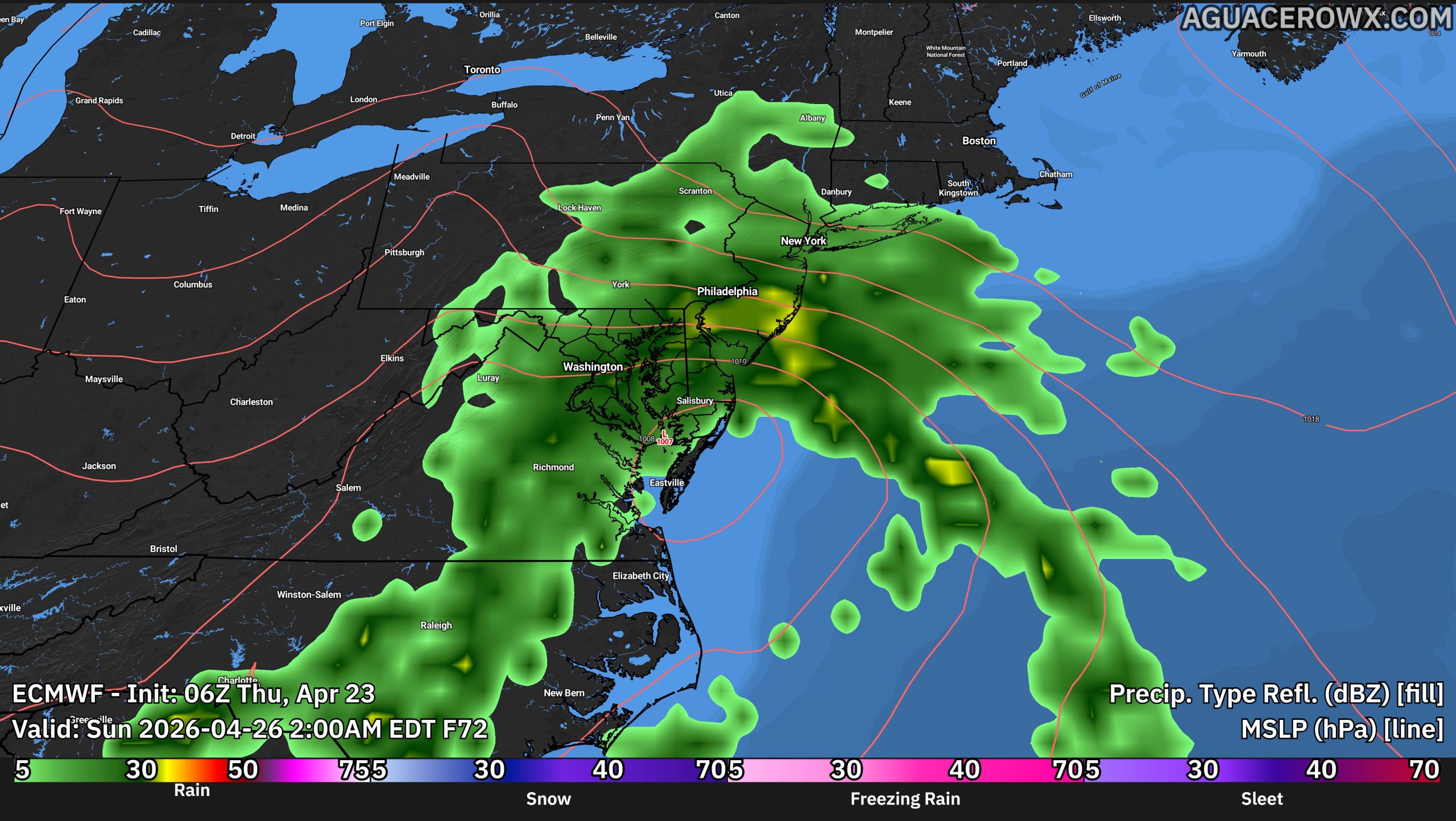
A stretch of unsettled weather is expected across the Delmarva region beginning later today and continuing through Thursday as an area of low pressure and an approaching cold front move through the eastern United States.
According to the latest details, an upper-level trough connected to a closed low over central Canada will swing through the Great Lakes and Ohio Valley tonight before settling into the Northeast by Thursday. While the main surface low will remain well north of Delmarva, its associated cold front will cross the region and bring periods of showers along with the chance for a few isolated thunderstorms.
The timing of rainfall has slowed somewhat compared to earlier expectations. Only scattered showers are expected to begin developing across northern and western portions of the region around midday Wednesday, while the steadier and more widespread rainfall is now expected to hold off until later this evening and overnight.
Although thunderstorms remain possible later today and tonight, the overall severe weather threat remains very low. Limited atmospheric instability, also known as CAPE, is expected to keep thunderstorm coverage isolated at best. The Storm Prediction Center is not expecting severe thunderstorms across the region during this event.
Rainfall totals also continue trending lower with most locations expected to receive between one tenth and one quarter of an inch of rain. Locally higher amounts could occur underneath any thunderstorm, but widespread heavy rainfall is not anticipated. The highest rainfall totals are expected farther north across portions of the southern Poconos and northern New Jersey.
Temperatures ahead of the system will remain seasonably mild today with highs reaching the lower to middle 70s across much of Delmarva, though some far northwestern areas may stay in the 60s. Cooler air arrives behind the cold front on Thursday with daytime highs generally falling back into the 60s region-wide.
While this system is not expected to produce severe weather, residents should still prepare for periods of wet weather, occasional downpours, and a few rumbles of thunder through Thursday before improving conditions gradually return later in the week.
FORT LAUDERDALE, Fla. (AP) — Firefighting teams continue working to control two major wildfires that have consumed thousands of acres across South Florida’s Everglades region, with both blazes expanding Monday despite ongoing containment efforts.
According to a Facebook update from the Florida Forest Service, the expanding fires are creating heavy smoke and limiting visibility across the area, though containment efforts are being ramped up. Authorities report no significant injuries or structural damage at this time.
The more extensive fire has now consumed approximately 5,600 acres in wilderness areas located southwest of Fort Lauderdale, with firefighters achieving 30% containment, according to state officials. National Guard personnel are providing support to state and local firefighting teams.
Emergency response teams are simultaneously working to suppress a separate 300-acre fire burning near Homestead in southern Miami-Dade County, which has also reached 30% containment, authorities reported.
Arid weather conditions have contributed to wildfire activity across multiple regions nationwide. Similar blazes destroyed numerous residences in southern Georgia during the previous month.
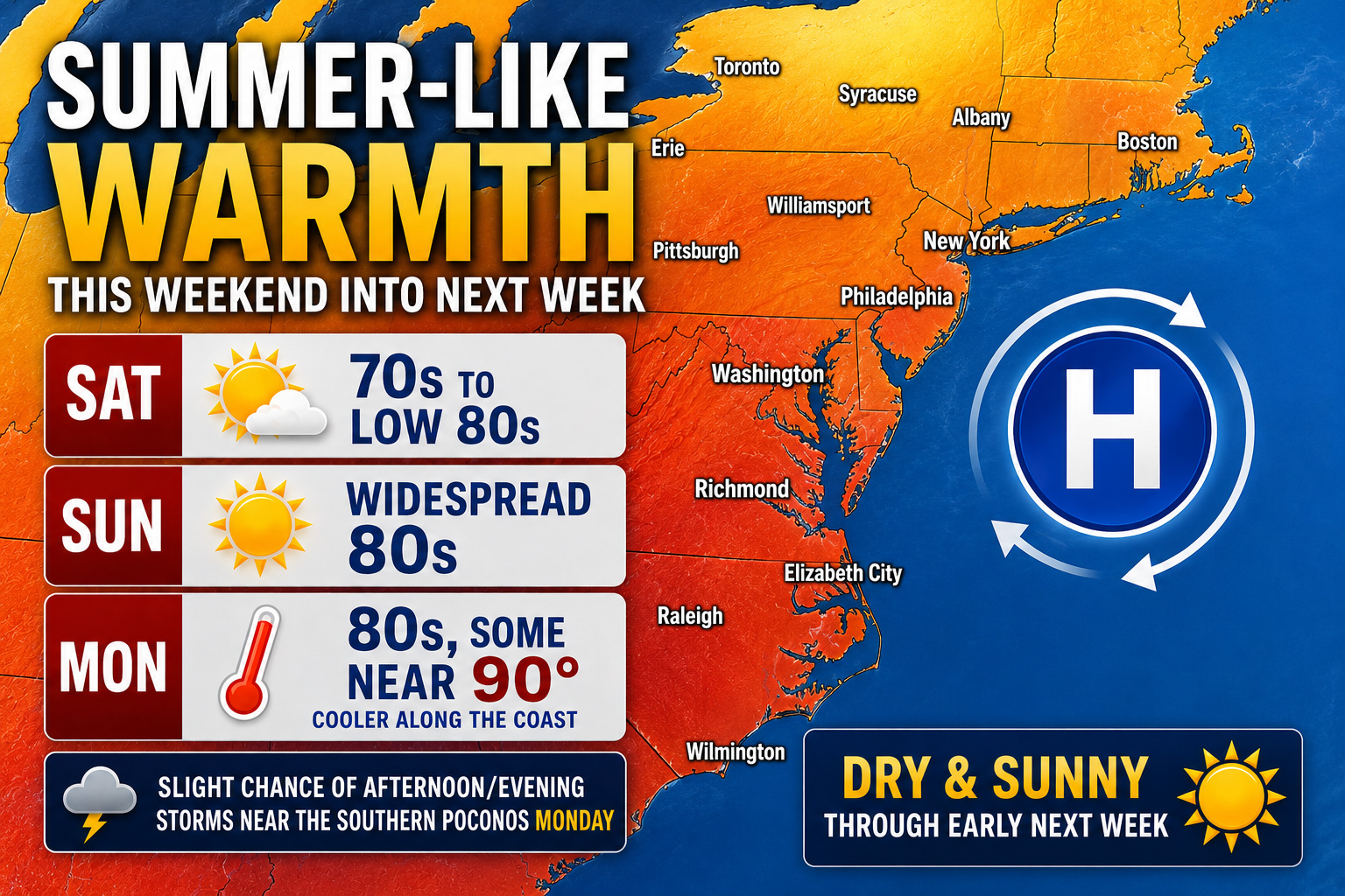
A major warm-up is expected across the Delmarva region this weekend into early next week as high pressure builds across the eastern United States.
After cooler and unsettled weather this week, a developing ridge of high pressure and persistent southerly winds will transport much warmer air into the Mid-Atlantic. Temperatures are forecast to climb into the 70s and lower 80s Saturday before widespread 80s arrive Sunday.
Even warmer conditions are possible Monday, with some inland areas potentially nearing 90 degrees. Coastal communities will likely stay cooler thanks to the influence of the Atlantic Ocean and southerly winds.
The strengthening ridge is also expected to keep conditions mainly dry through early next week, providing several days of sunshine and summer-like warmth across the region. While a slight chance for isolated thunderstorms may develop near the southern Poconos Monday afternoon, no widespread rainfall is expected across Delmarva.
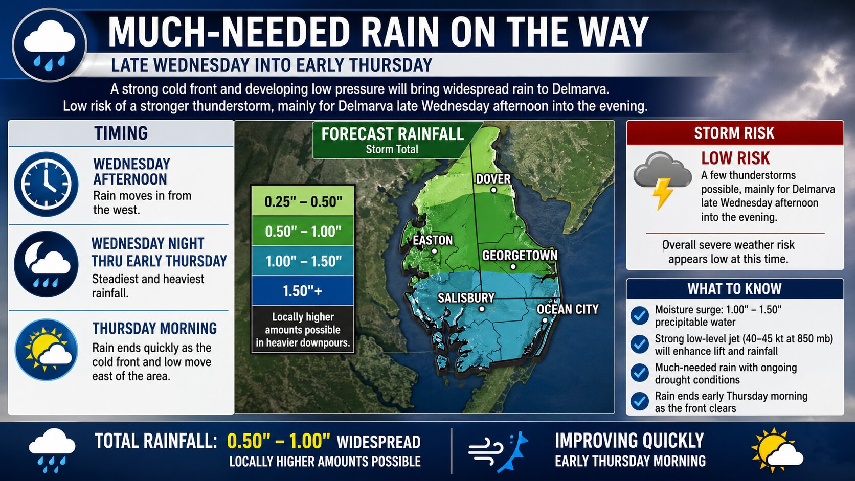
A more unsettled weather pattern is expected to return to the Delmarva region during the middle of the week as an upper-level storm system approaches from the west. Showers are expected to increase Wednesday afternoon and continue through Wednesday night, with a few thunderstorms also possible before conditions gradually improve Thursday.
We are tracking an upper-level trough that is expected to evolve into a closed low over the Mid-Atlantic and Northeast by Thursday. As this system approaches, a warm front lifting northward across the region Wednesday will help increase moisture and atmospheric lift. This setup is expected to lead to showers developing from west to east during the afternoon hours, with the steadiest and most widespread rainfall occurring Wednesday night as a cold front pushes through the area.
While severe weather is not expected to be a major concern across Delmarva, enough instability may develop to support a few thunderstorms Wednesday afternoon into Wednesday night. The better chance for stronger thunderstorms is expected to remain farther west where instability and wind shear will be greater. However, locally heavy downpours and occasional lightning will still be possible with any thunderstorms that develop locally.
Rainfall totals are currently forecast to range between around 0.20 and 0.50 inches across much of the region, though isolated higher amounts could occur where more organized showers or thunderstorms develop. The rainfall will provide some beneficial moisture to the region following recent dry conditions, though this does not appear to be a widespread heavy rain event.
By Thursday, the main cold front and deeper moisture will begin shifting offshore. However, with the closed low potentially moving overhead and colder air aloft lingering across the region, additional scattered showers may redevelop during the day Thursday before the system finally departs later in the day or Thursday night.
Temperatures will also trend cooler Thursday behind the cold front, with more seasonable conditions expected heading into the end of the week.
After several stretches of cooler and unsettled weather recently, a much warmer pattern is expected to develop across the Mid-Atlantic and Delmarva region heading into this weekend and continuing through much of next week. Forecast guidance is increasingly pointing toward a significant warm up that could bring the first widespread taste of summer-like conditions to the region this season.
Temperatures are expected to steadily climb beginning this weekend as an upper-level ridge builds across the eastern United States. This pattern shift will allow warmer air from the southern United States to expand northward across much of the East Coast. At the same time, the jet stream is forecast to retreat well north into southern Canada, limiting the delivery of cooler Canadian air masses into the region.
By Saturday, temperatures across Delmarva are expected to rise into the lower 80s under increasing sunshine. The warmer air mass will continue building Sunday with highs likely reaching the middle 80s in many inland locations. Some traditionally warmer spots could approach the upper 80s by early next week.
Forecast data from the National Blend of Models continues to show temperatures climbing through much of next week across Sussex County and surrounding areas. High temperatures could approach 90 degrees by Monday and Tuesday if enough sunshine develops. Overnight temperatures are also expected to become increasingly mild with lows rising into the lower to middle 60s, adding to the more summer-like feel.
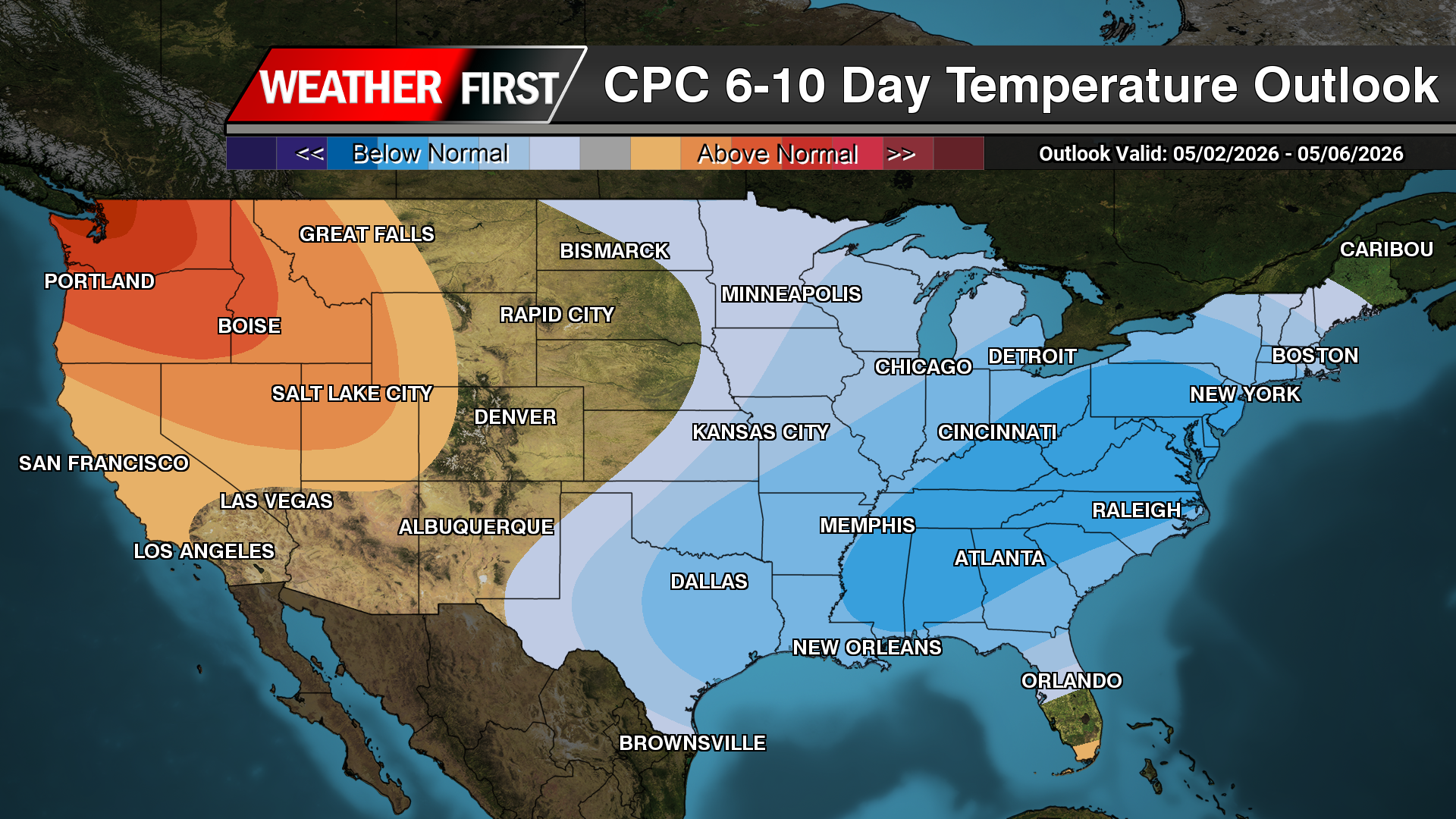
The large-scale pattern strongly supports above-average temperatures not only locally, but across much of the eastern half of the United States. The latest Climate Prediction Center 6-to-10 day temperature outlook continues to highlight a high probability of above-normal temperatures stretching from the Gulf Coast through the Mid-Atlantic and Northeast.
Upper-air pattern forecasts also show expanding ridging and higher 500mb heights across the eastern United States during the middle of next week. This is typically associated with warmer and more stable weather conditions, especially during the late spring and summer months.
While the warmer temperatures will be welcomed by many after recent cool spells, the increasing heat and sunshine may also begin drying out soils once again across portions of the Mid-Atlantic. The region has dealt with periodic dry conditions this spring, and several consecutive warm days could enhance evaporation rates heading deeper into May.
At this time, the overall pattern suggests the warm conditions may persist through a large portion of next week, although occasional isolated showers or thunderstorms cannot be ruled out during the afternoons as humidity gradually increases.
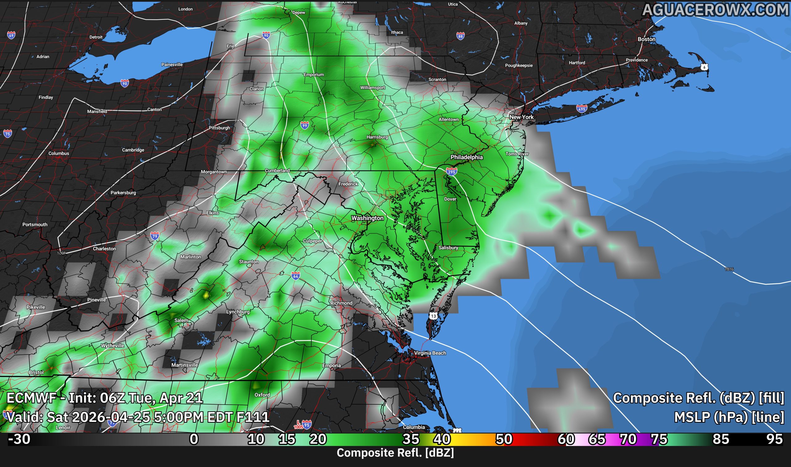
A more active weather pattern is expected to develop across the Mid-Atlantic and Delmarva region during the middle of the week as a strengthening upper-level storm system moves into the eastern United States. The unsettled conditions are expected to bring a round of showers and potentially a few thunderstorms Wednesday afternoon through Wednesday night before a much warmer and drier pattern takes hold heading into the weekend.
We are closely monitoring an amplified upper-level weather pattern that will evolve over the next several days. High pressure currently influencing the region will shift offshore by Tuesday, allowing warmer and more humid air to begin moving northward into the Mid-Atlantic. At the same time, another upper-level trough will dig into the eastern United States Wednesday into Thursday.
There remains some uncertainty regarding exactly how the system evolves. Some forecast guidance, particularly the European ECMWF model, continues to suggest the upper-level trough could close off into a stronger upper-level low over the Mid-Atlantic and Northeast. Other guidance keeps the system more progressive and open as it moves through the region. Regardless of the exact setup, confidence is increasing that widespread showers will develop Wednesday afternoon and continue into Wednesday night as a trough and cold front move across the area.
Ahead of the approaching system, increasing low-level warm air advection and strengthening winds aloft will help enhance atmospheric lift across the region. A warm front is also expected to lift northward through the area Wednesday, further supporting the development of showers and scattered thunderstorms.
Rain is expected to overspread the region from west to east during the day Wednesday, with the steadiest and most widespread activity likely occurring Wednesday evening and overnight as the cold front approaches. While widespread severe weather is not anticipated at this time, enough atmospheric instability may develop to support a few thunderstorms capable of producing locally gusty winds. The overall intensity of any thunderstorms will depend on how much instability can build ahead of the front during the afternoon and evening hours.
By Thursday, the main area of rain and thunderstorms should shift offshore. However, if the upper-level low closes off as some guidance suggests, colder air aloft moving overhead could spark additional scattered showers Thursday afternoon and potentially linger into Friday before the system fully departs.
Conditions are expected to improve significantly heading into the weekend as the upper-level trough lifts away and a ridge of high pressure begins building into the eastern United States. This will allow a much warmer and drier air mass to overspread the Mid-Atlantic and Delmarva region. Temperatures are expected to climb well above average by the weekend with increasing sunshine and more favorable outdoor conditions returning.
Delaware Department of Transportation officials have implemented a temporary speed reduction on Interstate 495, dropping the limit to 55 miles per hour due to current weather conditions affecting the roadway.
The speed restriction has been put in place as a safety measure to help protect motorists traveling on the interstate during adverse weather. DelDOT monitors road conditions continuously and adjusts speed limits when necessary to maintain safe driving conditions.
Drivers are advised to exercise caution while traveling on I-495 and to observe the posted reduced speed limit. The temporary restriction will remain in effect until weather conditions improve and normal speed limits can be safely restored.
Climate forecasting models are indicating the development of an El Niño weather pattern that meteorologists say could shatter historical records and deliver unprecedented extreme weather conditions across the globe.
“I think we’re going to see weather events that we’ve never seen in modern history before,” said Jeff Berardelli, WFLA-TV Chief Meteorologist and Climate Specialist based in Tampa, Florida, speaking on Friday.
The World Meteorological Organization anticipates this El Niño phenomenon will emerge around mid-year, significantly affecting temperature and precipitation patterns worldwide. Though forecasting models suggest this could be an exceptionally powerful event, the WMO notes that springtime predictions tend to be less reliable.
This cyclical natural occurrence involves the warming of specific areas in the equatorial Pacific Ocean, which subsequently disrupts global weather systems. La Niña represents the opposite phase, characterized by below-average ocean temperatures.
According to Berardelli, El Niño essentially moves heat around the planet. Currently, warm water beneath the Pacific’s surface is traveling eastward and rising from deeper layers to the surface, marking El Niño’s early development phases.
The WMO’s Global Seasonal Climate Update documented rapidly increasing sea-surface temperatures. Wilfran Moufouma Okia, WMO’s chief of climate prediction, expressed strong confidence in El Niño’s emergence, followed by continued strengthening over subsequent months.
The WMO reports that El Niño events generally happen every two to seven years and persist for approximately nine to 12 months.
Daniel Swain, a climate scientist with the California Institute for Water Resources, believes the forecasting models appear accurate. He explained that the size and strength of the subsurface warm water anomalies — unusual warm water pulses that drive El Niño’s mechanics — rank among the largest observed in recorded history.
Meteorologists classify the most powerful occurrences as “super El Niños.”
“One of the key building blocks to make it fully materialize is, in fact, occurring,” Swain stated Friday. “We still don’t know exactly what’s going to happen. It’s not guaranteed it’ll be a super El Niño. But the potential is there for something genuinely remarkable.”
When the Pacific Ocean releases substantial amounts of heat, it amplifies the climate system and creates weather chaos, Berardelli explained. Increased heat will generate more severe heat waves and worsen drought conditions in certain regions, while simultaneously adding moisture to the atmosphere that produces more devastating floods.
El Niño also reduces Atlantic hurricane activity because the Pacific’s intense heat overshadows the Atlantic, Berardelli noted. Areas like the Caribbean will experience particularly dry conditions this summer with fewer tropical weather systems expected.
The phenomenon creates worldwide consequences. Throughout the United States, this summer appears likely to be hotter than typical, featuring substantial heat waves, Berardelli said. While precise details remain difficult to determine this far in advance, Berardelli also anticipates more regular daily thunderstorms across the southwestern United States.
Amazon forest deterioration, caused by wildfires, logging, and drought, currently impacts approximately 40% of the region. A strong El Niño could worsen this situation in 2026.
The additional heat that El Niño brings to the surface, combined with ongoing planetary warming from climate change, will produce record-setting global temperatures, Swain predicted. He anticipates seeing unprecedented global warm temperatures either later this year, next year, or during both periods.
“All indicators are, at this point, that the next year is going to be a pretty wild year from a global climate perspective,” Swain said.
University of Pennsylvania climate scientist Michael Mann noted that while El Niño temporarily increases global temperatures for one to two years, it represents essentially a “zero-sum game.” The pattern typically shifts back toward La Niña, which subsequently decreases global temperatures for a similar duration. The real concern, Mann emphasized Friday, is the long-term, consistent warming trend that will persist as long as fossil fuel consumption continues.
Storm chaser Ashton Lemley was navigating through the devastation of a Mississippi mobile home community when he detected the distinct cry of a small cat cutting through the early morning silence.
The residential area had been completely destroyed just hours before when severe weather systems generated no fewer than three tornadoes throughout southern Mississippi, leaving a dozen people hurt at the mobile home park in the small town of Bogue Chitto.
Though Lemley couldn’t pinpoint the kitten’s location, he remained committed to locating the animal. The crying suddenly ceased after several minutes, leaving Lemley worried about the kitten’s fate.
However, the meowing resumed five minutes afterward.
“I said, ‘Oh, he’s still alive!’” Lemley shared with The Associated Press on Thursday.
Lemley immediately began digging beneath insulation material from a destroyed wall until his flashlight illuminated the kitten — soaked, frightened and crouched between two wooden supports.
The rescue was recorded on video: “Oh my goodness, I found him!” he tells the camera. “Are you OK? Come here – it’s OK. … We’ll get you cleaned up, baby. Don’t you worry.”
After cradling the kitten briefly, Lemley transferred it to a United Cajun Navy commander, a volunteer emergency response organization member, who dried the animal and ensured its safety. Lemley was amazed the kitten showed no signs of harm.
“I’ve been in these situations so many times,” explained Lemley, who has pursued severe weather since 2010. “I don’t try to get overly emotional. But it is very heartbreaking to see any type of animal or human go through something like that.”
According to Lemley, numerous people have expressed interest in adopting the kitten should its original family not be found. Several potential adopters, he noted, want to call it Tornado.
The kitten won’t be joining Lemley’s household, however: he has a cat allergy.
The latest U.S. Drought Monitor shows drought and abnormally dry conditions continuing across parts of the Mid Atlantic this week, with recent rainfall helping in some areas but not enough to erase longer term precipitation deficits.
The national drought summary released May 5 noted that light to moderate precipitation moved across the Northeast during the past week. However, rainfall was uneven across the region. The highest totals fell farther north into Maine, while many drought affected areas of the Mid Atlantic and southern New England received less than a half inch of rain. Cooler than average temperatures helped reduce evaporation rates, which limited more widespread drought expansion.
For the Mid Atlantic, the main issue remains the lack of consistent, soaking rainfall. While occasional showers have moved through the region, many areas continue to deal with dry soils, reduced streamflows and lingering hydrologic stress from months of below normal precipitation.
Delaware remains one of the areas closely being monitored. The Delaware Climate Office reported that precipitation has continued to lag statewide, with eight consecutive months of below normal precipitation going back to last fall. The office also noted that streamflows are down statewide, groundwater continues to struggle to recover, and warmer early season temperatures have increased evapotranspiration, leading to greater water loss from the environment.
Soil moisture has also become a growing concern. According to the Delaware Climate Office, Delaware and much of the Mid Atlantic are experiencing low soil moisture values for this time of year. Soil moisture statewide was estimated in the 35 to 45 percent range, well below the typical 55 to 70 percent range expected during this part of the spring.
The dry pattern has important implications as the growing season continues. Early season crops, lawns, gardens and natural vegetation can become increasingly vulnerable when rainfall remains inconsistent. Dry fine fuels, including grasses, leaves and brush, can also increase the risk for rapid fire spread during periods of low humidity and gusty winds.
Drought.gov notes that drought in the Mid Atlantic can affect agriculture, water resources and wildfire risk, even though the region is often more commonly associated with flooding and heavy precipitation events. The Mid Atlantic Drought Early Warning System covers Delaware, Maryland, New Jersey, Pennsylvania, Virginia, West Virginia and Washington, D.C., helping coordinate drought monitoring and response across the region.
Looking ahead, the U.S. Drought Monitor outlook section indicates that precipitation is favored along the Ohio Valley and much of the eastern seaboard, with the best potential for drought relief farther north into the Northeast. However, somewhat drier conditions across portions of the Mid Atlantic may limit meaningful improvement in drought conditions.
For Delmarva and nearby portions of the Mid Atlantic, the message remains the same: periodic rain chances may offer short term help, but it will likely take multiple rounds of widespread, soaking rainfall to bring lasting improvement to soil moisture, streamflows and groundwater levels.
A gradual warming trend is expected to develop across the Delmarva region this weekend, though the warmer temperatures will come alongside several opportunities for showers and thunderstorms through early next week.
Temperatures through Saturday are expected to remain seasonable for early May, with afternoon highs generally in the upper 60s to near 70 degrees and overnight lows ranging from the mid 40s to low 50s.
The weather pattern is forecast to become increasingly unsettled beginning Saturday as an upper level disturbance moves across the Mid Atlantic during the afternoon hours. An associated area of low pressure tracking north of the region will drag a cold front through Delmarva, likely triggering scattered to potentially widespread showers and thunderstorms from late Saturday morning into Saturday afternoon.
Forecast models indicate modest atmospheric instability developing ahead of the front, with around 500 J/kg of elevated instability forecast across portions of the region. In addition, stronger winds aloft may help organize some of the storms. While widespread severe weather is not currently expected, forecasters say a few stronger thunderstorms cannot be ruled out as the system approaches.
At this time, the primary threats with any stronger storms would likely be gusty winds and brief heavy downpours, though confidence in the overall storm intensity remains somewhat limited.
Conditions are expected to improve Saturday night into Sunday as the disturbance exits the region and high pressure briefly builds overhead. This setup should provide mainly dry weather for much of Sunday while also allowing significantly warmer air to surge northward into the region.
High temperatures Sunday are forecast to climb into the upper 70s across much of Delmarva, and a few inland locations could approach the 80 degree mark if enough sunshine develops during the afternoon.
The warmer weather may be short lived, however, as another area of low pressure and its accompanying cold front are expected to move through the region Sunday night into Monday morning. This next system could bring another round of showers and thunderstorms before cooler temperatures return to begin the new work week.
Despite the active weather pattern, no widespread hazardous weather is anticipated at this time. However, residents are encouraged to continue monitoring the forecast through the weekend as details regarding Saturday’s thunderstorm potential become clearer.
JACKSON, Miss. (AP) — Devastating weather systems swept across Mississippi Wednesday evening, with at least one verified tornado wreaking havoc on communities and leaving hundreds of residences in ruins, according to state officials.
Fortunately, authorities reported no fatalities or serious injuries from the severe weather that impacted multiple counties across the state.
A trailer park in Bogue Chitto, located in Lincoln County, sustained extensive destruction from the storms.
“I was just watching TikTok on my bed and thought it was thunder. I went to my living room. I went back to my room, and the room’s gone,” resident Max Mahaffey told WAPT-TV.
Mahaffey escaped without harm, though his grandmother injured her ankle and several neighbors received cuts and bruises during the ordeal.
Weather officials described “a very large and dangerous tornado” that traveled from eastern Lincoln County through Lawrence County.
Governor Tate Reeves confirmed that several tornadoes struck central and western regions of Mississippi, with the state’s Emergency Management Agency now coordinating relief operations.
“Pray for Mississippi,” he posted online.
Lincoln County emergency officials confirmed significant destruction and multiple injuries occurred, but emphasized no lives were lost.
“Damage assessments are ongoing, there are multiple roads blocked in the county we ask that you please refrain from sightseeing as crews are working,” the emergency management department posted early Thursday.
Additional severe weather was forecast for Thursday, with tornado risks extending across Alabama, Georgia, and Florida, meteorologists warned. The Carolinas and Texas also faced potential for dangerous storms.
Delaware Department of Transportation has implemented a temporary speed reduction on Interstate 495, lowering the limit to 55 miles per hour due to dangerous weather conditions affecting the roadway.
The speed restriction has been put in place as a precautionary measure to ensure motorist safety during the current weather event impacting driving conditions on the highway.
Drivers traveling on I-495 are advised to reduce their speed accordingly and exercise extra caution while navigating the affected stretch of roadway until conditions improve and normal speed limits are restored.
An unsettled weather pattern will continue across the Delmarva region through the upcoming weekend, bringing occasional chances for rain along with a gradual warming trend by the end of the weekend.
Following a cold front moving through Wednesday night into early Thursday, another weak area of low pressure is expected to develop along the stalled boundary just south of the region. This system may bring additional light rain to parts of Delmarva and southern New Jersey Thursday morning, although recent forecast trends have shifted the system slightly farther south, reducing overall rainfall coverage.
Outside of any lingering showers, Thursday will feel noticeably cooler for early May standards. Afternoon temperatures are expected to remain mainly in the 60s under mostly cloudy skies and a cooler northerly flow.
Conditions improve briefly on Friday as high pressure builds into the Mid Atlantic. This should allow for drier weather and at least partial sunshine across much of the region before the next systems arrive over the weekend.
We are monitoring additional weak disturbances that could bring scattered showers back into the forecast for Saturday and again later Sunday. At this time, these systems appear relatively weak and are not expected to produce significant impacts. Instead, they may simply act as occasional interruptions to outdoor plans during the weekend.
Temperatures will begin moderating Saturday with highs reaching the 60s to lower 70s across much of Delmarva. A more noticeable warmup is expected by Sunday as highs climb into the 70s, with some inland locations potentially nearing 80 degrees if enough sunshine develops.
Despite the periodic shower chances, no severe weather or flooding concerns are anticipated at this time. Overall, the pattern favors generally light precipitation and seasonable to slightly below average temperatures before warmer air returns by the end of the weekend.
FORT COLLINS, Colo. (AP) — An unexpected spring snowstorm battered Colorado on Wednesday, forcing educational institutions to cancel classes, grounding flights, and creating treacherous driving conditions across the region.
The weather system moved through the Rocky Mountains and onto the High Plains starting Tuesday, with forecasters predicting it would diminish by Wednesday evening after depositing heavy, moisture-laden snow at higher altitudes.
Weather officials issued winter storm warnings lasting through the afternoon, forecasting an additional 2 to 4 inches of accumulation for Fort Collins, Boulder, Denver metropolitan region, and Castle Rock, according to the National Weather Service.
“We expect roads to be slick during heavier snow showers, but for the lower elevations, any road accumulations will melt quickly as snow showers subside,” the weather service office in Denver posted online Wednesday.
The mountain community of Jamestown, Colorado, located near Boulder, measured 16.3 inches of snow by early Wednesday morning, weather officials reported. Estes Park, situated close to Rocky Mountain National Park, documented 17 inches of accumulation by Tuesday evening.
Boulder municipal authorities, after receiving nearly 6 inches of snow by Tuesday’s end, warned residents about fallen trees and limbs, urging people to stay away from areas with heavy snow-laden branches.
The Mile High City confronted what could become its heaviest snowfall this season. Denver International Airport, which experienced delays and flight cancellations early Wednesday, measured 3.7 inches of snow by 2 a.m., meteorologists confirmed.
Cold temperatures also dropped dramatically. Denver, experiencing temperatures in the low 30s Wednesday morning, implemented its emergency cold weather shelter protocols.
Milder conditions are anticipated to return Thursday, forecasters indicated.
Denver Public Schools, the state’s most extensive educational district, along with other major regional school systems and universities, suspended Wednesday instruction because of dangerous weather conditions.
The threatening weather predictions didn’t prevent thousands from attending David Guetta’s performance at Red Rocks Amphitheatre Tuesday evening, though event organizers moved the starting time earlier by one hour hoping to get attendees home before conditions worsened.
Concert attendees wrapped themselves in heavy winter jackets and knit caps while queuing to enter the open-air venue.
The weather system forced the Colorado Rockies to postpone two matchups against the New York Mets. However, such rescheduling occurs frequently during Denver’s spring baseball calendar, including four occasions in 2015, MLB records show.
May snowfall isn’t unusual for Colorado. Such weather happens even more frequently in Cheyenne, Wyoming’s capital, which sits almost 1,000 feet higher than Denver and maintains cooler year-round temperatures. Wyoming also experiences stronger winds than Colorado, creating snow drifts requiring repeated plowing when gusts continue.
April brought warmer than typical temperatures and limited moisture, with Denver receiving an inch less rain and 2.8 inches less snow last month compared to average conditions.
For certain agricultural producers dealing with Colorado’s persistent drought conditions, the snowfall presented an opportunity.
Adam Jones, who operates Unsung Family Farms in Longmont, told KMGH-TV that he had planted carrot seeds several days earlier to capitalize on the incoming precipitation.
“You can’t get as even distribution with driplines or sprinklers,” he said. “There’s nothing like starting seeds with snow or water.”
Jones needed to relocate his more temperature-sensitive plants indoors, using heating equipment to maintain proper growing conditions.
The unstable weather patterns extend beyond the Rocky Mountain region.
Dangerous thunderstorms with tornado potential threatened the Southeast on Wednesday.
The most intense storms were anticipated from Arkansas extending through Georgia.
Budget reductions at the National Weather Service resulted in the elimination of dawn weather balloon releases, which may have contributed to forecasters missing two significant tornado events this spring.
The staffing reductions forced meteorologists to scale back their early morning atmospheric data collection efforts. Weather balloons launched during these early hours provide crucial information about atmospheric conditions that help predict severe weather patterns.
Following these operational changes, two separate tornado outbreaks occurred during the spring season without adequate advance warning from weather forecasters. The timing of these missed predictions has raised concerns about the impact of reduced resources on public safety.
The connection between the reduced monitoring capabilities and the unexpected severe weather events highlights ongoing challenges facing the weather service as it operates with fewer resources while maintaining responsibility for protecting communities from dangerous weather conditions.
Today marks the official start of the 2024 Atlantic hurricane season, which runs through November 30th. Emergency management officials are reminding residents along the Eastern Seaboard to take this opportunity to review their storm preparedness plans.
The hurricane season timeline gives coastal communities six months to potentially face severe weather threats. Weather experts emphasize that preparation should begin well before any storms develop in the Atlantic basin.
Residents are encouraged to create emergency kits, review evacuation routes, and ensure they have adequate supplies including water, non-perishable food, flashlights, batteries, and important documents stored in waterproof containers.
Emergency management agencies recommend families develop communication plans and identify safe locations where they can shelter if evacuation becomes necessary. Property owners should also review their insurance coverage and document their belongings before storm season intensifies.
Historical data shows that hurricane activity typically peaks between mid-August and late October, giving residents several weeks to finalize their preparation efforts.
While many Americans across the country are enjoying spring weather and tending to their gardens, residents of Colorado and Wyoming are dusting off their snow shovels for what could be a significant late-season storm.
A major weather system is approaching the Rocky Mountain region and High Plains, initially bringing rainfall that forecasters expect will transition to snow in the Denver metropolitan area by Tuesday evening. The National Weather Service predicts accumulations could reach 8 inches, with mountainous areas potentially receiving up to 12 inches of snowfall.
This storm has the potential to become Denver’s most substantial snowfall of the entire winter season.
“We just had our driest winter on record,” said Kenley Bonner, a meteorologist with the National Weather Service’s Denver office. “We were kind of joking earlier in the season that winter’s not going to come until spring, and it did exactly that.”
Weather officials warn that snowfall will persist through Wednesday, followed by dramatically dropping temperatures and widespread freezing conditions overnight.
The heavy, moisture-laden snow poses risks for downed tree limbs and electrical outages, Bonner cautioned. Power companies are taking precautionary measures, with Xcel Energy placing 165 workers on emergency standby throughout Colorado.
While uncommon, such late-season weather events aren’t unprecedented for the region.
Denver’s average final snowfall typically occurs around April 28, though May snowstorms do occur periodically. The city recorded half an inch of snow on May 21, 2022, while the nearby community of Boulder received 4.5 inches during that same event.
Weather records show Denver has experienced at least five May snowstorms producing more than 10 inches of accumulation. The most severe occurred in 1893, delivering 15.5 inches. The city’s most recent double-digit May snowfall happened on May 25-26, 1950, when 10.7 inches fell.
The latest recorded snowfall in Denver occurred on June 2, 1951, though it was only a light dusting.
Last month brought above-normal temperatures and below-average precipitation to the area, with Denver receiving one inch less rain and 2.8 inches less snow than typical April totals.
However, this single weather event won’t address the broader water shortage challenges facing western states.
According to a recent assessment from the National Drought Mitigation Center, while recent moisture has improved surface soil conditions and reduced irrigation needs, the overall water supply outlook remains “mostly bleak” heading into summer months.
The unstable weather pattern extends beyond the Rocky Mountain region.
Severe thunderstorms are forecast from northeastern Texas through western Tennessee, with Arkansas facing the highest probability of large hail, destructive winds, and potential tornado activity, according to the Storm Prediction Center. Some strong storms may also develop across portions of the Northeast.
A developing El Niño signal across the Pacific Ocean is gaining attention from forecasters, with new data from the Climate Prediction Center and the European Centre for Medium-Range Weather Forecasts suggesting the potential for a strong event later this year.
Current observations show warming sea surface temperatures across the central and eastern equatorial Pacific, a key indicator that El Niño conditions are beginning to take shape. Forecast guidance from the Climate Prediction Center indicates a high likelihood of El Niño developing by summer, with increasing confidence that it could persist and strengthen into the fall and winter months.
The European Centre for Medium-Range Weather Forecasts supports this trend, with seasonal model output pointing toward continued ocean warming through the second half of the year. Some ensemble members suggest sea surface temperature anomalies in the Niño 3.4 region could exceed 2 degrees Celsius, which would place this event in the strong category if realized.
El Niño occurs when warmer than average ocean water develops across the tropical Pacific, disrupting normal atmospheric circulation patterns. This shift alters the jet stream and can influence weather across much of the globe, including North America.
For the United States, a strong El Niño typically shifts the jet stream farther south. This pattern often results in wetter conditions across the southern tier of the country and can bring more active storm tracks across parts of the East. In contrast, northern areas may trend milder overall.
Another important impact is on the Atlantic hurricane season. El Niño tends to increase wind shear across the Atlantic Basin, which can suppress tropical development and reduce the number of storms.
Globally, strong El Niño events are often associated with above average temperatures and an increased risk of extreme weather events, including flooding in some regions and drought in others.
For the Delmarva region, the most noticeable impacts typically arrive during the late fall and winter months when El Niño reaches peak intensity. This can influence storm tracks and precipitation patterns, though exact local impacts vary depending on how the pattern evolves.
Forecasters caution that uncertainty remains, especially during the spring when long range predictions are more challenging due to what is known as the spring predictability barrier. However, the agreement among multiple climate models and ongoing ocean warming signals suggest that a significant El Niño event is increasingly possible.
We will continue to monitor conditions across the Pacific in the coming months as the strength and impacts of this developing pattern become clearer.
A series of weak weather systems will bring periods of showers to the Delmarva region from Wednesday into Thursday, delivering much-needed rainfall without significant impacts.
The first system arrives as a cold front approaches from the Great Lakes late Tuesday night, with showers beginning to develop early Wednesday. The steadiest rainfall is expected during the midday hours Wednesday as the front moves into the region. However, the boundary is forecast to stall near or just east of the area, setting the stage for additional development along the coast.
A secondary area of low pressure is expected to form over the Southeast and track northeast along the stalled front toward the Mid-Atlantic coastline. Recent forecast trends have shifted this system slightly farther south and east, which will likely limit rainfall coverage across inland areas. As a result, the highest rain chances, around 50 to 70 percent, are expected across southern and eastern portions of Delmarva and into southern New Jersey. Areas north and west of the Interstate 95 corridor may see more limited coverage, with chances closer to 20 to 40 percent.
Rainfall totals have also trended lower with this shift in track. Most locations are expected to receive around a half inch of rain, with isolated areas potentially approaching one inch. The probability of exceeding one inch has decreased significantly, now generally below 10 percent across most of the region, with only localized higher chances in far southeastern Delmarva and coastal New Jersey.
Despite the presence of multiple systems, atmospheric conditions are not favorable for severe weather. Limited instability is expected, keeping the risk for strong thunderstorms and flooding very low. However, an isolated thunderstorm cannot be ruled out.
Overall, the rainfall is expected to be beneficial, helping to ease dry conditions across parts of the region without bringing hazardous weather.
Looking ahead to the weekend, another weak system may approach on Saturday. This system could bring additional scattered showers, but at this time, it appears to be a minor disturbance with no significant impacts expected beyond a potential interruption to outdoor plans.
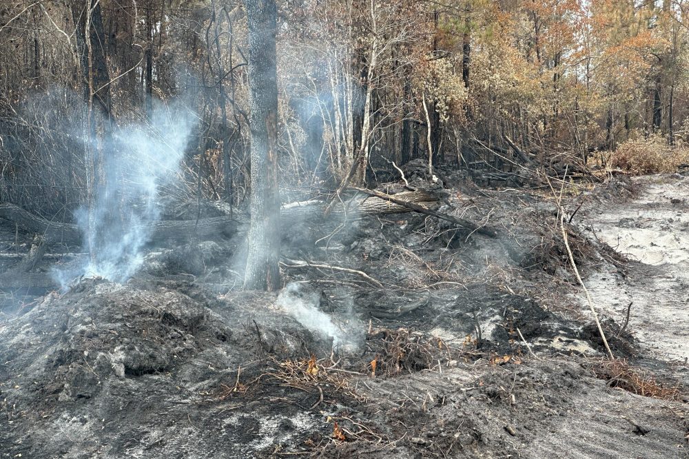
An elevated risk for fire spread is in place across Delaware and portions of central and southern New Jersey today as a combination of dry air, warm temperatures, and gusty winds creates conditions favorable for rapid fire growth.
According to the latest forecast, relative humidity values are expected to fall to around 25 to 30 percent this afternoon. At the same time, temperatures will climb into the 80s, while southwest winds increase to 15 to 20 mph with gusts reaching up to 30 mph. This combination of low humidity and strong winds significantly enhances the potential for any fires that develop to spread quickly and become difficult to contain.
The setup is driven by a dry air mass and efficient boundary layer mixing, allowing stronger winds aloft to transfer down to the surface. The resulting environment promotes rapid drying of fine fuels such as grasses and leaf litter, which are especially susceptible to ignition and fast-moving fire behavior.
Fire officials emphasize that even a small spark could lead to a rapidly spreading wildfire under these conditions. Outdoor burning is strongly discouraged across the region. Residents are urged to properly dispose of smoking materials and to use caution when operating equipment such as lawn mowers or other machinery that could generate sparks.
Conditions are expected to improve later this evening as winds begin to diminish and relative humidity values recover, reducing the overall fire danger heading into the overnight hours.
This elevated fire risk assessment accounts for current meteorological conditions as well as fuel dryness and land characteristics, and has been issued in coordination with state fire management officials.
Severe dry weather across Florida has reached such extreme levels that numerous lakes are completely disappearing, creating a critical situation for the state’s alligator population.
The prolonged lack of rainfall has caused water levels to drop dramatically, forcing these large reptiles to abandon their traditional territories as their aquatic homes evaporate.
Wildlife officials are monitoring the situation as the ongoing water shortage continues to impact native species throughout the region.
With the 2026 Atlantic Hurricane Season fast approaching, running from June through November with the most dangerous storms typically striking between August and October, local officials are urging Delaware residents to begin their emergency preparations now.
Rehoboth Beach Police Chief Keith Banks and 911 Communications Manager Nicholas Priddy recently traveled to Orlando, Florida, to participate in the 2026 National Hurricane Conference from March 30 through April 2. The yearly gathering connects emergency response professionals, weather experts, and law enforcement officials from throughout the nation to exchange proven strategies, receive specialized training, and enhance their ability to prepare for, respond to, recover from, and reduce the impact of major storms.
The specialized education and hands-on experience these officials received will help guarantee our local area is equipped to act swiftly and protect citizens when dangerous weather threatens the region.
Local authorities recommend residents begin taking these essential safety measures: • Create or refresh your disaster supply kit including water, non-perishable food, prescription drugs, flashlights, and fresh batteries • Establish a household emergency response plan with clear communication methods • Monitor reliable weather reporting services and local emergency notifications • Bring in loose outdoor furniture and check your property insurance policies • Familiarize yourself with designated evacuation paths and nearby emergency shelters
Taking action now to prepare could prove crucial when severe weather strikes. Remain vigilant and stay prepared.
A multi-day stretch of unsettled weather is expected to bring periods of rain across the Delmarva Peninsula, southern New Jersey, and the Maryland Western Shore from late Tuesday night through Thursday, followed by the chance for a few additional showers heading into the weekend.
High pressure will remain in control through much of Tuesday, keeping conditions mainly dry across the region. However, a cold front dropping southeast from the Great Lakes will begin to approach by late Tuesday. While most locations stay dry during the day, a few isolated showers cannot be ruled out Tuesday evening into the overnight hours, especially toward the northern portions of the coverage area including southern New Jersey and the Maryland Western Shore.
The more widespread rainfall arrives late Tuesday night into Wednesday morning as the cold front pushes into the region. Rain is expected to continue through much of Wednesday across Delmarva, southern New Jersey, and the Maryland Western Shore. By Thursday, the front is forecast to stall nearby, allowing a wave of low pressure to track along it and prolong the period of unsettled weather with additional rounds of rain.
Despite the extended duration of precipitation, this setup is not expected to bring significant severe weather or flooding concerns. Atmospheric instability remains limited, which should keep any thunderstorm activity isolated and non-severe. Rainfall totals will vary, but there is roughly a 15 to 30 percent chance of seeing at least one inch of rain across Delmarva, with slightly higher probabilities closer to southern New Jersey and the Maryland Western Shore. Given the ongoing dry conditions across the region, this rainfall is expected to be largely beneficial, helping to ease developing drought concerns.
Looking ahead to the weekend, a weaker system may bring scattered light showers on Saturday. At this point, impacts appear minimal, though it could interrupt outdoor plans briefly. Overall, the pattern favors a welcome stretch of much-needed rainfall before quieter conditions return.
Worcester County authorities have enacted an emergency fire restriction starting immediately as drought conditions and dropping water levels create dangerous fire hazards throughout the region.
Fire Marshal Owens announced the decision, stating: “Due to the County’s current dry conditions, low precipitation totals, and declining water table levels, the burn ban is effective immediately. This ban should reduce the number of out-of-control outside fires, which cause safety concerns for area residents, visitors, and especially responding fire personnel.”
The restriction prohibits most outdoor fires and ignition sources, though several activities remain permitted including:
Gas and charcoal grilling when used appropriately
Fires at commercial campgrounds within the county
Campfires at state and federal camping facilities
Authorized Ocean City bonfire events
Small recreational fires on private property (maximum 2-foot area, 3-foot height)
Public fireworks shows
Fire department training activities
County officials will maintain the restriction until weather conditions improve and safe burning can resume.
Environmental Programs Director Bob Mitchell explained the scope of the ban: “All existing outdoor burn permits have been rescinded. Conditions remain dry, rainfall has been below normal, and County monitoring indicates that water table levels remain low. These conditions increase the potential for rapid fire spread and support the need for this temporary ban.”
Officials are asking residents and visitors to exercise extreme care with any outdoor fire sources and stay informed about updates to the restriction.
Questions about the fire ban can be directed to the Worcester County Fire Marshal’s Office at 410-632-5666.
An increased risk for fire spread is expected to develop across the Delmarva region on Sunday as a dry and breezy weather pattern takes hold behind a departing offshore storm system.
As the coastal low pulls farther out to sea, high pressure will begin building in from the southeastern United States. This setup will tighten the pressure gradient locally, leading to a strengthening northwest wind across the region. At the same time, the atmosphere is expected to mix deeply during the day, allowing very dry air from aloft to be transported down to the surface.
Forecast soundings indicate an unusually deep mixed layer for this time of year, potentially extending up to around 700 mb. This efficient vertical mixing will help drive down dew points more than typical model guidance suggests, especially given the tendency for models to overestimate moisture in springtime patterns like this. As a result, relative humidity values are expected to fall to around or below 30 percent during the afternoon hours.
Even though temperatures will run slightly below average, generally about 5 to 10 degrees cooler than normal, the combination of dry air and increasing winds will create an environment supportive of fire growth. Wind gusts are expected to reach 20 mph or higher at times, which, when combined with low humidity, can allow any fires that ignite to spread quickly.
The overall fire risk will ultimately depend on the condition of local fuels, but given the recent dry stretch across parts of the region, the potential for rapid fire spread cannot be ruled out. Residents are urged to avoid outdoor burning and to exercise caution with any activities that could produce sparks.
Conditions are expected to improve later Sunday evening as winds begin to diminish and humidity levels recover.
A developing offshore storm system expected to impact the Mid-Atlantic this Saturday is showing signs of shifting farther east, a trend that could significantly reduce rainfall chances for inland areas of the Delmarva Peninsula.
Latest model guidance from the 00Z cycle indicates a subtle but important eastward adjustment in the track of the coastal low. If this trend holds, the bulk of the precipitation shield would remain offshore, with only coastal counties seeing measurable rainfall. Areas farther inland, including much of central and western Delmarva, may end up largely dry.
Despite this shift, forecast confidence remains somewhat limited given that this is a relatively recent trend in the guidance. Current forecasts still maintain at least a chance of showers extending as far west as the I-95 corridor, reflecting a blend of solutions that have not fully locked in on the more offshore track.
In addition to reduced rain chances inland, this eastward shift has implications for wind impacts as well. With the strongest pressure gradient now expected to remain offshore, wind speeds across Delmarva on Saturday may be lighter than previously anticipated. Earlier projections suggested a breezier day, but current trends point toward more modest wind conditions, especially away from the immediate coastline.
Extended drought conditions have pushed Corpus Christi, Texas to the edge of a critical water crisis, threatening drinking water access for nearly 500,000 residents as local freshwater supplies continue to disappear.
The coastal Texas community is now confronting the possibility of a water emergency declaration as prolonged dry conditions have severely depleted the region’s freshwater reserves, creating an urgent situation for the city’s substantial population.
Drought conditions continue to grip much of the Mid-Atlantic region as we move deeper into spring, with little relief in sight despite occasional rainfall events.
According to the latest U.S. Drought Monitor, much of the region remains under some level of drought or abnormal dryness, driven by persistent precipitation deficits over the past several months. Many areas across the Mid-Atlantic have seen rainfall totals running well below normal, with deficits ranging several inches over the past 30 to 60 days.
Maryland and Delmarva Remain a Focus
The most concerning conditions continue across Maryland and the Delmarva Peninsula. Recent data shows a large portion of Maryland is experiencing moderate to severe drought, with millions of residents impacted.
On the Eastern Shore and across Delmarva, drought conditions have intensified enough to trigger official drought warnings in some areas, reflecting worsening soil moisture, groundwater concerns, and ongoing precipitation shortfalls.
In Delaware specifically, the situation has been driven by a prolonged stretch of dry weather. March marked the eighth consecutive month of below-normal precipitation, and April has continued that trend, with rainfall totals running well below average statewide.
Wider Mid-Atlantic Overview
Across the broader Mid-Atlantic region, drought conditions have fluctuated week to week, but the overall trend remains concerning. While there have been minor improvements in some areas, moderate drought (D1) still persists and has even expanded in pockets due to continued dryness and limited meaningful rainfall.
This ongoing dryness follows what has been described as one of the more significant drought stretches in recent decades for parts of the region, with impacts extending across agriculture, water resources, and ecosystems.
Impacts Being Felt Now
The effects of the drought are already being felt across the region:
Agriculture: Crop stress and delayed planting concerns are increasing, with some counties already receiving federal drought disaster designations.
Water Resources: Rivers and streams, including portions of the Potomac River basin, are running at unusually low levels for this time of year, raising concerns heading into summer.
Soil Moisture: Continued deficits are leading to dry soils, increasing fire risk and reducing the effectiveness of light rainfall events
Looking Ahead
While periodic systems may bring some rainfall in the coming weeks, widespread drought relief will likely require multiple soaking rain events over an extended period. With temperatures expected to trend warmer at times, evaporation rates could further limit the effectiveness of incoming precipitation.
For now, the Mid-Atlantic remains locked in a pattern that favors continued drought concerns, especially across Maryland and the Delmarva Peninsula, where conditions are among the most significant in the region.
A pair of low pressure systems will impact the Delmarva region from Friday night through the weekend, bringing periods of light rain, gusty onshore flow, and a return to below-average temperatures.
The first system, a weak area of low pressure, is expected to pass through the region Friday night. This will deliver a quick shot of light precipitation, with most areas seeing minimal rainfall totals. Impacts from this initial system appear limited, but it sets the stage for a more complex setup heading into Saturday.
Attention then turns to a stronger system developing to the south. A deep upper-level trough digging across the Midwest and Gulf Coast states will help spawn a more organized area of low pressure over the southeastern United States. This system is forecast to lift north toward the Mid-Atlantic during the day Saturday before tracking offshore by Saturday night into Sunday.
For Delmarva, this track is critical. Current trends suggest the heaviest rainfall will remain offshore, particularly east of the coastline. However, wraparound moisture on the backside of the system will likely spread clouds and occasional rain back into the region, especially across Delaware and far southeastern New Jersey where rain chances are highest.
While this will not be a washout for most, periods of light rain and persistent cloud cover are expected through at least part of the weekend. The combination of onshore flow and thick cloud cover will also keep temperatures suppressed, with highs generally stuck in the 50s to low 60s, well below late-April normals.
Overall, the weekend will feature more clouds than sun, with occasional showers and a cool, damp feel. While beneficial rainfall is possible in spots, the bulk of the system’s moisture is expected to remain just offshore, limiting more widespread or heavier totals across the region.
Flying glass fragments surrounded Eric Gockel as he endured what meteorologists are calling one of Missouri’s most devastating hailstorms on record.
The massive ice chunks that pummeled the Springfield region on Tuesday reached an enormous 4.75 inches in diameter. The destructive storm claimed the life of a zoo emu, left several motorists injured, cut electricity to thousands of residents, and caused extensive damage to hundreds of cars and aircraft.
“I consider myself fortunate to have escaped without injury,” said Gockel on Wednesday, describing how his windshield was destroyed while he sheltered in his vehicle on a highway shoulder during the storm’s passage.
The destructive spring weather pattern affecting the South and Midwest brought what emergency officials are calling Springfield’s most severe hailstorm ever recorded, though it didn’t break the state’s overall record. National Weather Service meteorologist Mark Burchfield in Springfield explained that Missouri’s record remains the 6-inch hail documented in 2004 near Maryville.
“This type of storm is extremely uncommon,” Burchfield explained regarding the Springfield event. “We witnessed a supercell thunderstorm with significant wind shear and tremendous energy that kept the hailstones suspended in the atmosphere for an extended period.”
Zoo staff at Springfield’s Dickerson Park Zoo attempted to bring animals indoors, including a 21-year-old female emu named Adam. However, spokesperson Joey Powell explained in a statement to The Associated Press that emus instinctively flatten themselves to the ground when seeking protection.
Adam succumbed to severe head injuries from the hail impact. Meanwhile, Oscar, a 17-year-old rhea (another flightless bird species), sustained hail injuries but was responding well to pain treatment Wednesday morning while the zoo remained temporarily closed.
The Springfield-Branson National Airport, located approximately 5 miles northwest of downtown, experienced some of the most severe destruction.
Airport public information officer Ren Luebbering reported that dozens of flights faced delays or cancellations, while hundreds of parked vehicles suffered shattered windshields and sunroofs.
Because rental vehicles were also damaged, some travelers required bus transportation roughly 100 miles to Bentonville, Arkansas’s airport. Luebbering described how airport personnel worked for three hours to cover the most severely damaged cars with donated tarps.
“Our team distributed approximately 300 to 400 tarps across the parking areas,” Luebbering stated. The airport posted online advisories warning visitors to “Expect damage to your vehicle.”
Nicolette Zangara from the Springfield-Greene County Office of Emergency Management said she anticipated trouble from the beginning.
“The radar imagery clearly showed the hail was increasing in size,” Zangara explained. “When we began receiving photographs from surrounding counties showing their hail damage, we immediately recognized this would be a devastating storm.”
She confirmed that several individuals contacted 911 reporting injuries from hail shattering their windshields, though specific injury counts weren’t available. Vehicle damage appears to represent the most widespread destruction, with Zangara describing her own car as so heavily dented it resembles “the surface of a golf ball.”
“Late April seems particularly unlucky for our region,” she observed, referencing severe spring storms that struck the area exactly one year earlier.
Since the storm passed, Gockel has been busy filing multiple insurance claims. The hail completely destroyed his home’s gutters, and contractors are scheduled to assess his roof damage.
As a pizza business owner, Gockel reported damage to his food truck, work vehicles, and his teenage daughter’s first car, which he had purchased for her just one month ago.
Despite being accustomed to severe weather alerts, Gockel typically responds by watching storms from his front porch rather than seeking shelter.
“Usually nothing dramatic actually happens,” he reflected. “This marks the first time I’ve experienced a storm that truly matched the severity of the advance warnings.”
Delaware Department of Transportation officials have implemented a temporary speed limit reduction on Interstate 495, lowering the maximum speed to 55 miles per hour due to current weather conditions.
The speed restriction has been put in place as a safety precaution to help motorists navigate the highway more safely during the ongoing weather event. DelDOT monitors road conditions continuously and adjusts speed limits when necessary to protect drivers.
Motorists traveling on I-495 are advised to reduce their speed, maintain safe following distances, and exercise extra caution while the weather-related speed limit remains in effect.
The temporary speed reduction will remain in place until weather conditions improve and normal driving conditions return to the area.
Weather officials have issued a coastal flood advisory that went into effect Monday evening and will remain active until early Tuesday morning.
The National Weather Service office in Mount Holly, New Jersey issued the advisory at 5:41 PM on April 29th, with the warning set to expire at 1:00 AM on April 30th.
Residents in coastal areas should be prepared for potential flooding conditions during the advisory period. The weather service typically issues these advisories when tidal flooding is expected in low-lying coastal areas.
MINERAL WELLS, Texas — Authorities verified Wednesday that a devastating tornado struck this small Texas community, hospitalizing five individuals while destroying manufacturing facilities and tearing roofs from residential properties.
City leaders said they prepared for the worst Tuesday when they witnessed structures crumbling as severe weather hammered Mineral Wells, a community of approximately 15,000 residents located west of Dallas.
“We are most grateful for no loss of life in this event yesterday,” Mayor Regan Johnson stated during Wednesday’s press briefing. “When you see the destruction that’s here, you can tell that’s really amazing.”
National Weather Service meteorologist Allison Prater from Fort Worth confirmed the tornado struck Mineral Wells with wind speeds reaching at least 120 mph. Weather officials dispatched a survey team Wednesday to assess the devastation in the area situated 80 miles west of Dallas.
Severe weather conditions have been battering regions throughout the South and Midwest. Two fatalities occurred in North Texas over the weekend when thunderstorms generated destructive tornadoes, while a Michigan resident died Monday after being struck by a storm-toppled tree.
Tuesday brought a hailstorm that damaged roofing, skylights and parked cars at a Springfield, Missouri zoo, also claiming the life of one of its large birds. A female emu named Adam succumbed to head injuries during the hailstorm at Dickerson Park Zoo, according to spokesperson Joey Powell’s Wednesday statement.
Additional severe weather remained possible Wednesday throughout the South and portions of the Mid-Atlantic region. Weather forecasters indicated a moderate risk of damaging winds and large hail across sections of Texas, Louisiana, Mississippi and Alabama.
In Mineral Wells, city officials addressed media Wednesday amid a neighborhood littered with broken lumber, downed trees and scattered debris.
Fire Chief Ryan Dunn reported that five storm victims required hospital treatment, while emergency responders treated others for minor injuries at the scene.
“As we arrived on scene, we noticed there was a lot of debris, a lot of roofs off,” Dunn explained. “And then we started seeing buildings collapse.”
Dunn noted that the tornado primarily impacted commercial and industrial zones, though residential properties also sustained damage. At least two manufacturing companies experienced significant destruction.
Ventamatic, a company producing large fans and ventilation systems in Mineral Wells, was among those affected. The business announced on its website that workers evacuated before the storm arrived and no employees were hurt. Wednesday operations ceased “due to severe damage and ongoing safety hazards,” the company reported.
More than 9,000 residences and businesses remained without power across Texas Wednesday afternoon, based on PowerOutage.us tracking data. Approximately 230 of those outages affected the Mineral Wells vicinity.
Mineral Wells authorities announced a local disaster declaration and established an overnight curfew continuing through Wednesday, Police Chief Tim Denison confirmed.
A developing coastal storm system could bring a period of rain to the Delmarva region on Saturday, though uncertainty remains regarding how widespread the impacts will be.
The setup involves a large, closed upper-level low lingering across southeastern Canada, with a stronger disturbance rotating around its base from the Ohio Valley into the Mid-Atlantic. This feature is expected to help generate an area of low pressure near or just south of the region. However, forecast models continue to differ on exactly where this surface low will track and how strong it becomes.
Some guidance like the ECMWF suggests a stronger system tracking farther north, which would spread a steady shield of rain across much of Delaware, Maryland’s Eastern Shore, and adjacent coastal areas. Other solutions, including the GFS model, depict a weaker and more southern track, which would keep the bulk of the rainfall offshore and result in more limited precipitation locally.
Despite the uncertainty, one consistent signal is that this system will be relatively fast-moving. Any rainfall that does develop would likely move through quickly rather than linger for an extended period.
In addition to the rain chances, temperatures across Delmarva are expected to run well below average for late April. The influence of the upper-level low will keep conditions noticeably chilly, with Saturday shaping up to be the coolest day of the weekend.
We will continue to refine the track and strength of this system over the coming days. A slight shift north or south will ultimately determine whether Delmarva sees a widespread soaking rain or only spotty, light precipitation.
SAVANNAH, Ga. — Fire officials in southern Georgia say they’re preparing for an extended firefighting campaign against two massive wildfires that have leveled dozens of residences, despite weekend rainfall that significantly aided containment operations.
“A little bit of rain is going to help us, but it’s not going to get us out of this situation,” Georgia Gov. Brian Kemp told a news conference after touring the fire areas Tuesday. “We’re going to be in this for a while.”
The blaze in rural Brantley County has scorched approximately 35 square miles and wiped out more than 80 residences, with containment levels jumping to 32% as of Tuesday, according to the fire command team. This marks a dramatic improvement from Monday’s 6% containment figure.
Sunday’s precipitation provided crews with the opportunity to expand containment barriers around the fire’s edges and eliminate smoldering hotspots, according to Johnny Sabo, director of the Georgia Forestry Commission.
“As that number increases, our confidence at holding it in that footprint increases,” Sabo told reporters. He added: “We have a long way to go. I just want to stress that.”
A second, more extensive wildfire spanning the Georgia-Florida border has consumed over 50 square miles in the lightly populated Clinch and Echols counties. Sabo reported that firefighting teams have successfully prevented this blaze from expanding beyond its current boundaries for four consecutive days, with containment at 23% on Tuesday.
The second fire destroyed one residence along with several dozen outbuildings and smaller structures, said Don Thomas, a Georgia Forestry Commission spokesperson.
An abnormally high number of wildfires are active this spring throughout the Southeast region. Researchers attribute the elevated fire risk to a deadly combination of severe drought conditions, strong winds, climate change effects, and accumulated dead plant material.
Georgia has reported no fire-related injuries or fatalities. However, a volunteer firefighter in Nassau County, Florida, died last week after experiencing an unspecified medical emergency while fighting a brush fire.
Improvements in controlling the Brantley County fire led local authorities to cancel evacuation orders Monday for approximately 1,500 residents who had abandoned their homes. Around 2,500 people remain displaced, said Susan Heisey, a spokesperson for the fire command team.
Returning residents have been cautioned by local authorities to stay ready for potential re-evacuation if conditions deteriorate.
Both Georgia fires started during the state’s most severe drought in two decades, which has left extensive pine forests and wetland areas extremely dry and prone to ignition.
Fire investigators determined the Brantley County blaze began April 20 when a metallic balloon contacted a power line, generating an electrical discharge that ignited ground vegetation. The Clinch and Echols counties fire started April 18 from a spark that fell while a man was welding a gate, state officials reported.
Weather predictions indicate high probability of additional rainfall over the fire zones this weekend. Thunderstorms are also possible, which could generate lightning strikes capable of starting new fires.
Authorities have not provided estimates for how long the Georgia fires might continue burning, stating only that substantial rainfall will be necessary to fully extinguish them.
Sabo referenced a massive lightning-sparked fire in the nearby Okefenokee Swamp in 2011 that burned for nearly twelve months.
A key piece of weather monitoring technology has reached a significant milestone after serving the eastern United States for twelve months.
NOAA’s GOES-19 satellite officially completed one full year of operations as GOES-East on April 28, providing essential weather data and imagery for the entire eastern seaboard, including Delaware and the Mid-Atlantic region.
The advanced geostationary satellite has delivered vital information during numerous high-impact weather events throughout its first year of service. From tracking severe thunderstorms to monitoring hurricane development, GOES-19 has enhanced forecasting capabilities for meteorologists across the region.
Since taking over the GOES-East position, the satellite has continuously observed weather patterns from its position 22,300 miles above Earth’s equator. This strategic location allows it to maintain constant surveillance of weather systems affecting the eastern United States.
The satellite represents the latest in weather monitoring technology, offering improved resolution and faster data transmission compared to its predecessors. These enhancements have translated into more accurate forecasts and earlier warnings for potentially dangerous weather conditions.
GOES-19’s successful first year demonstrates the ongoing advancement of satellite technology in protecting communities through better weather prediction and monitoring capabilities.
The National Weather Service’s Tsunami Warning Center conducted a routine emergency alert test on Sunday afternoon, issuing a practice tsunami warning that remained active for exactly one hour.
The test alert was activated at 12:31 PM EDT on April 28th and concluded at 1:31 PM EDT the same day. These periodic drills are conducted by the National Tsunami Warning Center to ensure emergency communication systems function properly during actual coastal emergencies.
Such testing exercises help verify that warning systems can effectively reach coastal communities and emergency management agencies when real tsunami threats arise.
A widespread round of much-needed rainfall is expected to move into the Delmarva region late Wednesday, continuing overnight into early Thursday as a strong cold front pushes through the Mid-Atlantic.
The system is being driven by a robust upper-level trough and developing area of low pressure tracking across the eastern United States. As this setup evolves, a surface low is forecast to develop along the cold front and track near or across the southern half of the region early Thursday morning, enhancing rainfall coverage across Delaware and the Eastern Shore of Maryland.
Rain is expected to begin as early as Wednesday afternoon from west to east, with the steadiest and heaviest rainfall occurring Wednesday night into the pre-dawn hours Thursday.
Atmospheric moisture will be notably elevated ahead of the front, with precipitable water values climbing to around 1.00 to 1.50 inches. In addition, a strengthening low-level jet of 40 to 45 knots at approximately 850 mb will promote strong warm air advection and lift, allowing for periods of moderate to occasionally heavy rain.
While widespread severe weather is not expected, a few embedded thunderstorms cannot be ruled out, particularly across Delmarva late Wednesday afternoon into the evening. Instability remains limited due to expected cloud cover, but if any breaks develop allowing for greater surface heating, a low-end risk for a stronger thunderstorm could emerge given the favorable wind shear in place.
Overall rainfall totals are expected to range between one-half inch and one inch across the region, with locally higher amounts possible where heavier downpours occur.
The rain will be beneficial, especially as much of the region continues to experience longer-term dry conditions and emerging drought concerns. The steady rainfall should help improve soil moisture and reduce ongoing fire weather concerns that have developed in recent weeks.
Conditions will improve quickly early Thursday morning as the cold front and associated low pressure system exit the region, bringing an end to the rain and a return to drier weather.
Delaware Department of Transportation officials have completely shut down a section of Airport Road due to flood conditions making travel unsafe.
The roadway closure affects traffic in both directions between Hope Center and MacArthur Drive, where standing water has made the road impassable for vehicles.
DelDOT is monitoring the situation and has not provided an estimated time for reopening the affected stretch of roadway.
Drivers are encouraged to seek alternative routes and avoid the area until flood waters recede and normal traffic patterns can resume.
BRUNSWICK, Ga. — Weekend rainfall provided much-needed assistance to firefighters working to control two major wildfires burning across southern Georgia, both of which have destroyed more than 100 homes combined.
While the precipitation aided firefighting operations, it was not sufficient to extinguish the flames completely, and fire crews responded to 10 additional blazes across the drought-affected state on Sunday, according to Monday’s announcement from the Georgia Forestry Commission.
The largest fire, known as the Pineland Road Fire, has consumed over 50 square miles (130 square kilometers) and destroyed at least 35 residences in a lightly populated, heavily forested region located approximately 35 miles (56 kilometers) north of Florida, where wildfires are also burning. The area contains abundant highly flammable dead trees and vegetation left behind after Hurricane Helene cut a devastating path northward in September 2024.
The second-largest blaze, called the Highway 82 Fire, has been active since April 20 in an area roughly 60 miles (97 kilometers) to the northeast. According to Monday’s data release, this fire has eliminated at least 87 homes and burned through more than 35 square miles (90 square kilometers), with only 6% containment achieved.
“The fire basically doubled last night in size,” Brantley County Manager Joey Cason wrote in a Facebook post on Sunday. “It is a dynamic fire event that will be impacted by the wind.”
Officials believe the Highway 82 fire began when a foil balloon made contact with energized power lines, creating an electrical arc that ignited flammable materials on the ground. Investigators suspect the Pineland Road fire originated from sparks produced during a welding operation.
An exceptionally high number of wildfires are active this spring throughout the Southeast region. Fire crews have been combating more than 150 additional wildfires in Georgia and Florida combined.
Researchers indicate the fire risk has been intensified by a combination of severe drought conditions, strong winds, climate change effects, and dead trees and vegetation.
Georgia has reported no fire-related fatalities or injuries. However, in northern Florida, Nassau County Sheriff’s Office volunteer firefighter James “Kevin” Crews passed away Thursday evening after experiencing an unspecified medical emergency while fighting a brush fire.
KANSAS CITY, Mo. — Powerful thunderstorms swept through Midwest communities Monday, bringing dangerous hail, fierce winds and torrential rainfall that turned streets into rivers and left drivers trapped in their vehicles, according to emergency officials.
Weather forecasters warn that over 64 million residents across the Midwest face continued threats from severe weather Monday afternoon and evening, with the St. Louis area facing elevated risks for sustained tornado activity and damaging hailstones, the National Weather Service reported.
“The greatest area of concern is across central Missouri into southern Illinois and into southeast Missouri,” said Evan Bentley, a meteorologist with the National Weather Service Storm Prediction Center in Norman, Oklahoma, in a post on X.
“We could have multiple supercells capable of all hazards, including tornadoes, large hail and wind gusts,” Bentley explained.
Emergency responders in Kansas City, Missouri, conducted 11 vehicle water rescues beginning just before 6 a.m. Monday, according to Battalion Chief Riley Nolan in an email statement.
Most incidents occurred “in our typical ‘high-water’ areas following heavy rains,” Nolan noted. He reported that rescue boats were not needed and no one was injured during the operations.
Weather monitoring equipment at Kansas City International Airport recorded 3.2 inches of rainfall during a six-hour span that concluded around 7 a.m., meteorologists reported.
Monday’s dangerous weather continued a pattern of destructive storms from the weekend.
In northern Texas, tornado-spawning thunderstorms claimed at least two lives and forced at least 20 families from their homes after severe damage to residential properties, officials announced Sunday.
Weather service investigation teams verified that an EF-2 tornado with maximum winds reaching 135 mph struck the Runaway Bay region Saturday. A separate EF-1 tornado with peak winds of 105 mph was documented in the Springtown vicinity, meteorologists confirmed.
“Access has been difficult due to blocked roadways and downed utilities, but crews have continued pushing forward to reach those in need,” stated Wise County Judge J.D. Clark, who serves as the county’s chief executive.
A prolonged stretch of cooler-than-average temperatures is expected to impact much of the eastern United States through at least the first half of May, according to the latest outlooks from the National Oceanic and Atmospheric Administration’s Climate Prediction Center.
The agency’s 6- to 10-day outlook, valid May 2 through May 6, shows a broad area of below-normal temperatures expanding from the Mississippi Valley into the Mid-Atlantic and Southeast. That trend continues and strengthens in the 8- to 14-day outlook for May 4 through May 10, with much of the eastern half of the country favored to remain cooler than average.
Forecasters say the pattern is being driven by persistent upper-level troughing and a tendency for northwest flow across the eastern U.S., allowing cooler air masses to repeatedly move into the region. While these outlooks reflect probabilities rather than exact temperatures, the consistency between forecast periods increases confidence in a sustained cooler pattern.
Longer-range guidance continues that signal. The Week 3-4 outlook, covering May 9 through May 22, maintains below-normal temperature probabilities across parts of the Midwest, Great Lakes, Ohio Valley and Mid-Atlantic, suggesting the cooler regime may persist well into mid-May.
For the Delmarva Peninsula, this pattern could result in temperatures running several degrees below seasonal averages on multiple days. High temperatures may struggle to reach typical early May levels, especially during periods of cloud cover and rainfall associated with passing disturbances.
Coastal areas may see an even more pronounced cooling effect, as onshore flow and relatively cold ocean temperatures limit daytime warming. Instead of sustained warmth, conditions are expected to remain more typical of early spring, with occasional fluctuations depending on individual weather systems.
While brief warm-ups are still possible, forecasters say the overall trend points toward a delayed arrival of consistent early-season warmth across the region.
A portion of Masseys Church Road remains impassable after fallen trees and downed electrical wires created hazardous conditions for drivers.
Delaware Department of Transportation officials report the roadway is blocked between Black Diamond Road and Blackbird Forest Road while crews work to clear the debris and restore safe travel conditions.
Motorists are advised to seek alternate routes while cleanup efforts continue in the area.
A rapidly expanding wildfire burning through southeastern Georgia has now consumed more than 31 square miles, prompting officials to consider potential evacuations as the blaze continues to spread.
The fire, one of two major wildfires currently burning in the region, shows no signs of slowing down as it tears through Brantley County. Smoke from the massive blaze has been captured in aerial photographs released by Governor Brian Kemp’s office.
Emergency management officials are closely monitoring the situation as the fire’s growth raises concerns about nearby communities and infrastructure in the area.
RUNAWAY BAY, Texas — A deadly twister swept through northern Texas communities Saturday evening, claiming two lives and forcing at least 20 families to evacuate their damaged homes, local officials reported Sunday.
Rescue teams spent Saturday night and into Sunday clearing debris and navigating blocked roads in Runaway Bay to reach victims and provide emergency medical assistance, according to Wise County Judge J.D. Clark, the county’s top executive, during a Sunday press briefing.
“Access has been difficult due to blocked roadways and downed utilities, but crews have continued pushing forward to reach those in need,” Clark said. “Roads in the affected area will remain closed by law enforcement to ensure safety and allow emergency crews to manage the scene without obstruction.”
The deadly weather system also struck Springtown, where a second fatality occurred south of the city boundaries, Parker County Assistant Fire Chief David Pruitt confirmed in an email statement. The area suffered “significant damage,” according to Pruitt.
“One of the most significant ongoing challenges is the widespread power outage affecting many residents,” he wrote. “Officials are coordinating with utility providers and emergency partners as restoration efforts continue.”
Weather experts from the National Weather Service verified that an EF-2 category tornado with maximum winds reaching 135 mph struck the Runaway Bay region. Assessment teams were still evaluating damage in Springtown as of Sunday afternoon.
The destructive supercell storm system moved slowly through the region around 10 p.m. Saturday, according to meteorologist Patricia Sanchez from the Fort Worth weather service office.
The storm originated near Wichita Falls close to the Oklahoma state line, then traveled southeast while passing just west of Fort Worth. Runaway Bay sits approximately 45 miles northwest of Fort Worth along Lake Bridgeport, while Springtown is located roughly 30 miles northwest of the city.
Weather service radar detected a “potentially large and extremely dangerous” tornado approaching Azle at 10:14 p.m. Saturday, about 10 miles southeast of Springtown.
Delaware transportation officials have shut down a major roadway due to dangerous flooding conditions that have made travel impossible.
Airport Road is currently impassable in both directions between Interstate 95 at Exit 5A and MacArthur Road, according to the Delaware Department of Transportation.
The complete closure affects all vehicle traffic along this busy corridor, forcing drivers to seek alternate routes during their commutes.
DelDOT has not yet announced when the roadway might reopen, as crews continue to monitor the flooding situation.
Motorists are advised to plan extra travel time and use alternative routes until the water recedes and the road can safely accommodate traffic again.
NAHUNTA, Ga. — Residents in southeastern Georgia face urgent evacuation orders as two devastating wildfires continue burning through communities, with officials warning that incoming strong winds could rapidly accelerate the blazes.
Brantley County Manager Joey Cason described the circumstances as a “dynamic situation” during a Saturday morning social media video, urging citizens to “please evacuate” when authorities issue orders.
“This fire is going to move rapidly, once these winds get here later today,” he said.
The Highway 82 Fire, which ignited Monday, has leveled at least 87 residences. Georgia Governor Brian Kemp announced Friday that this represents the highest home destruction toll from any single wildfire in state records.
The blaze originated when a foil balloon contacted energized power lines, generating an electrical arc that sparked flammable materials below. Officials conducted overnight infrared heat-detection flights Friday to improve fire mapping efforts. Saturday’s update revealed the fire encompasses over 14.8 square miles with approximately 10% containment.
A separate blaze located roughly 70 miles southwest in Clinch and Echols counties near Florida’s border has consumed more than 46.9 square miles and demolished at least 35 residences. This fire, triggered by welding sparks, also remained about 10% contained by Saturday afternoon.
Fire crews are simultaneously combating over 150 additional wildfires throughout Georgia and Florida, creating smoky conditions that have reached distant areas and prompted air quality alerts in several cities.
The Southeast is experiencing an unusually high volume of spring wildfires. Researchers attribute the elevated fire risk to multiple factors including severe drought conditions, powerful winds, climate change effects, and debris from trees felled during 2024’s Hurricane Helene.
In northern Florida, Nassau County Sheriff’s Office volunteer firefighter James “Kevin” Crews lost his life Thursday evening after experiencing a medical emergency while fighting a brush fire. Georgia has reported no fire-related fatalities or injuries.
Georgia Governor Brian Kemp issued an emergency declaration Friday covering 91 counties as firefighters battle two devastating wildfires that have destroyed more than 120 homes and structures, setting a new record for property damage in the state’s history.
The two major blazes – known as the Highway 82 and Pineland Road fires – stand out among numerous wildfires currently burning across drought-affected areas of Georgia, Florida, South Carolina, and Alabama. One fire began when a party balloon made contact with power lines, while the other started from sparks created by welding equipment.
While Georgia has reported no deaths from the fires, a volunteer firefighter in northern Florida lost his life Thursday night after experiencing a medical emergency while battling a brush fire, according to media reports.
Officials say the widespread fires resulted from unusual weather patterns affecting the Southeast region.
The current fire season has been fueled by exceptionally dry conditions following last fall’s Hurricane Helene, which initially promoted heavy plant growth. The lack of spring rainfall has since turned that vegetation into tinder-dry fuel, creating fire risks more commonly seen in western states during summer months.
Georgia Forestry Commission Director Johnny Sabo explained the severity of conditions in an online video statement: “We are in extreme drought conditions, and wildfire activity has already surpassed our five-year average. Right now conditions are so dry that even one small spark can quickly turn into a dangerous wildfire.”
By Friday evening, the two primary fires had consumed more than 39,500 acres, destroying at least 122 homes and other buildings, according to state forestry officials. Governor Kemp confirmed during a news conference that this represents the largest property loss from wildfires in Georgia’s recorded history.
Close to 1,000 additional homes remain at risk, the governor noted.
The fires are spread throughout Georgia, with the two largest burning in the southeastern part of the state near the Florida border, approximately 250 miles southeast of Atlanta.
Television coverage has captured walls of pine trees consumed by flames, with Kemp describing “fire that is burning to the top of trees and burning from one treetop to another.”
Despite efforts by ground crews and water-dropping aircraft to stop the fires’ spread, firefighters are focusing on protecting homes still threatened by the blazes, Kemp said.
Emergency teams have succeeded in establishing containment barriers around 10% of each major fire’s perimeter, forestry officials reported.
Kemp’s emergency declaration for 91 of Georgia’s 159 counties is designed to speed up and coordinate the state’s disaster response efforts. Additionally, Sabo announced an unprecedented 30-day prohibition on outdoor burning of trash, farm waste, and campfires in those same counties – the first such ban in state history.
The causes of the two largest fires demonstrate how minor ignition sources can trigger massive blazes under current conditions.
Fire investigators found that the Highway 82 fire started Monday when an aluminum-coated balloon contacted a power transmission line, creating an electrical spark that ignited nearby vegetation.
The Pineland Road fire, which has been burning since April 18, began when a spark from welding work dropped onto the forest floor, officials determined.
Weather forecasters expect dangerous fire conditions to continue through the weekend, with strong winds predicted and minimal chances for rainfall.
Delaware Department of Transportation officials have implemented a temporary speed limit reduction on Interstate 495, lowering the maximum speed to 55 miles per hour due to dangerous weather conditions affecting the roadway.
The speed restriction has been put in place as a safety precaution to help protect motorists traveling on I-495 during the current weather event. Transportation authorities regularly adjust speed limits on state highways when conditions become hazardous for normal driving speeds.
Drivers are advised to exercise additional caution while traveling on the affected stretch of highway and to observe the reduced speed limit until conditions improve and normal speed limits are restored.
ENID, Okla. — A devastating tornado carved a path of destruction through Enid, Oklahoma, leaving behind a landscape of demolished buildings and widespread damage. The violent storm tore rooftops from residential properties, completely leveled business structures, and left debris strewn throughout the affected areas.
As the twister moved across the region, it toppled electrical lines, caused significant damage to numerous residences, and stripped vegetation from trees in its path. The severe weather event has left the Oklahoma community assessing the extensive impact left in the tornado’s wake.
A coastal low pressure system will bring a stretch of cool, damp, and breezy conditions to the Delmarva Peninsula this weekend, with the most impactful weather arriving Saturday night into early Sunday.
Saturday starts off mostly dry, but clouds will thicken through the day ahead of an approaching system. A few showers may begin to develop after 2 PM, though rainfall during the daytime hours looks light and spotty. High temperatures will struggle to reach the upper 50s, with an easterly wind increasing to 10 to 15 mph and gusts pushing up to 30 mph, especially near the coast.
Saturday Night is when conditions deteriorate more noticeably. Steadier rain moves in after 8 PM and continues overnight, with a high likelihood of widespread rainfall. Periods of moderate rain are possible, with totals generally between a quarter and half an inch. Overnight lows will fall into the mid 40s, while a persistent northeast wind around 15 mph keeps conditions raw and chilly.
Sunday remains unsettled, although trends suggest the steadiest rain shifts out of the region. Scattered showers will linger through the day under mostly cloudy skies. It will stay cool, with highs only in the low to mid 50s. Gusty northeast winds continue, with occasional gusts near 30 mph maintaining a brisk feel.
Sunday Night, conditions gradually improve as the system pulls away. A few leftover showers are possible early in the evening, but skies will begin to clear overnight. Lows drop into the lower 40s with lighter winds developing late.
NAHUNTA, Ga. — Emergency officials in rural Georgia are warning residents to be ready for immediate evacuations as a destructive wildfire continues to threaten communities after already leveling close to 90 homes.
Since starting Monday, the blaze in Brantley County has consumed more than 8 square miles, driven by strong winds through drought-stricken pine forests. The destruction includes scorched vehicle remains and damaged road signs scattered among burned tree stumps.
According to the Georgia Forestry Commission, firefighters had achieved 15% containment of the Brantley County fire by Friday. However, county leaders emphasized that weather conditions could quickly deteriorate.
“If you receive a mandatory evacuation notice, we need you to evacuate just as quickly as possible,” Joey Cason, county manager for Brantley County, said in a Facebook video Friday. “That containment can move from 15% to 0% in a matter of minutes with the wind.”
This fire represents just one of more than 150 active wildfires burning throughout Georgia and Florida, creating smoky conditions that have prompted air quality alerts in multiple cities.
Experts point to climate change, unprecedented drought conditions, and debris from Hurricane Helene in 2024 as contributing factors that have increased wildfire risk across the Eastern United States.
Approximately 200 Brantley County residents have been forced from their homes, leaving many concerned about abandoned pets and whether their properties will survive. Authorities report no casualties or injuries so far.
Emergency crews are using bulldozers to create firebreaks while firefighters from numerous local departments focus on structure protection by removing dry vegetation and continuously watering homes and surrounding areas.
“We’ve definitely had the local fire guys out there literally hosing stuff down,” said Seth Hawkins, a Georgia Forestry Commission spokesperson dispatched to the Brantley County fire.
Meanwhile, Georgia’s largest active fire near the Florida border has burned approximately 50 square miles in a remote area — roughly twice Manhattan’s size.
Florida firefighters were combating more than 120 wildfires Friday, primarily in the northern regions. Georgia fire crews responded to 31 additional small fires Thursday, according to state forestry officials.
Authorities say substantial rainfall is essential to extinguish the major blazes. Weather forecasts show a 20% to 40% chance of showers and possible thunderstorms this weekend in affected Georgia areas.
While precipitation might slow the fires’ progress, Hawkins explained it won’t eliminate them completely. Additionally, lightning from storms could ignite new fires.
“We’re going to need several inches of rain, and then maybe another blast of several inches, to extinguish this thing,” Hawkins said.
Destructive blazes continue ravaging communities across South Georgia, where flames have consumed close to 90 residential properties. The ongoing fires show no signs of slowing as they tear through the drought-stricken region.
Months of deteriorating dry conditions have created a perfect storm for fire activity, allowing flames to rapidly advance across the parched landscape. The extended period without adequate rainfall has left vegetation extremely vulnerable to ignition and has hampered firefighting efforts throughout the area.
ENID, Okla. (AP) — Emergency responders mobilized Thursday evening after a confirmed tornado swept through an Oklahoma community, stripping rooftops from structures and toppling electrical infrastructure near Vance Air Force Base, local authorities reported.
The National Weather Service verified the twister’s path through sections of Enid, home to approximately 50,000 residents located close to Oklahoma’s northern boundary. Online footage captured the spinning funnel cloud making ground contact alongside completely destroyed residences.
The Garfield County Sheriff’s Office reported no deaths and only minor injuries in the hours following the tornado’s passage. Law enforcement personnel conducted house-to-house wellness checks throughout affected neighborhoods.
Vance Air Force Base sustained tornado damage, though officials have not yet determined the full scope of destruction. Base leadership announced via social media that they “are currently conducting accountability procedures to ensure all personnel are safe and accounted for.”
“Please join me in praying for the Enid community, which has been severely impacted by tonight’s tornado,” Oklahoma Gov. Kevin Stitt posted on social media.
Enid Police Department spokesperson Cass Rains confirmed initial reports indicated residents trapped inside damaged homes and widespread property destruction. The affected Garfield County area encompasses Vance Air Force Base, situated roughly 80 miles north of Oklahoma City.
Multiple tornadoes tore through northern Oklahoma on Thursday, leaving at least 10 people with injuries, according to reports from KOCO News, an ABC affiliate.
The severe weather system brought substantial destruction to the region, with emergency responders launching search and rescue missions in the aftermath. Vance Air Force Base in Enid was among the areas that sustained damage from the tornado activity.
Rescue teams continue working in the affected areas as officials assess the full extent of the damage from Thursday’s severe weather outbreak.
Drought conditions remain a growing concern across the Mid-Atlantic this week, with the most significant impacts centered on the Maryland Western Shore, where severe drought (D2) continues to expand.
According to the latest update from the U.S. Drought Monitor, a large portion of the Maryland Western Shore is now classified under D2, or severe drought. This level of drought indicates widespread impacts, including stressed crops, reduced soil moisture, and increasingly strained water resources. The expansion of D2 conditions highlights the persistence of long-term rainfall deficits that have been building since last year.
Across Delmarva, conditions are somewhat less intense but still notable. Much of Delaware and the Eastern Shore of Maryland remain in abnormally dry (D0) to moderate drought (D1). While there have been minor week-to-week fluctuations, the overall trend continues to reflect lingering dryness, particularly in deeper soil layers. These deficits are becoming more important as the region enters the heart of the growing season.
The primary driver behind these conditions continues to be a prolonged stretch of below-normal precipitation dating back to the fall. Even with occasional rain events, the region has struggled to make meaningful progress in reducing long-term deficits. In many areas, groundwater levels and streamflows remain below normal, a clear signal that drought conditions extend beyond just surface dryness.
Agriculture is beginning to feel the impacts more directly, especially across the Maryland Western Shore where D2 drought is in place. Soil moisture shortages are making it increasingly difficult for crops to establish early in the season, and without consistent rainfall, stress on vegetation is expected to increase. On Delmarva, impacts are more gradual but still concerning, particularly for farmers relying on consistent spring moisture.
Looking ahead, there is some potential for relief. A developing pattern may bring periodic rainfall to the region over the coming weeks, including a system expected this weekend that could deliver a beneficial soaking rain. However, one or two rainfall events will not be enough to eliminate the drought. It will take a sustained period of above-normal precipitation to fully reverse the long-term deficits in place.
Until then, drought conditions will remain a key issue across both Delmarva and the Maryland Western Shore, with continued impacts expected for agriculture, water resources, and even elevated fire risk during dry and breezy periods.
NAHUNTA, Ga. — Devastating blazes across southern regions have compelled hundreds of Georgia families to abandon their homes within moments, creating anguish as they wonder about the fate of their properties and livestock.
This week’s infernos, occurring amid severe drought conditions affecting Georgia and Florida, have sent smoke plumes across vast distances, prompting additional air quality alerts throughout the Southeast on Thursday.
Fueled by powerful winds and minimal moisture in the air, the two largest blazes in southern Georgia have expanded quickly over recent days, claiming more than 50 residences in countryside communities. The escalating danger prompted additional evacuations and school shutdowns Wednesday.
“I don’t know if I have a house standing or not,” said Denise Stephens, who was forced to evacuate because of the fast-moving Brantley County fire near Georgia’s coast. “I know what it’s taken from other people, but I don’t know what I have left standing.”
The Brantley County blaze, responsible for most property destruction, held steady through the night, according to Thursday’s sheriff’s office report.
“While this stability is encouraging, wind conditions remain unpredictable and could cause conditions to change rapidly,” according to the update, which said the blaze is about 15% contained.
Officials have not yet determined what sparked these wildfires, though southern Georgia and northern Florida are experiencing exceptionally arid conditions.
The National Weather Service cautioned motorists in southeastern Georgia early Thursday that sight distance might drop to half a mile on certain roadways as wildfire smoke drifted through the region.
Sight distance proved particularly challenging in Clinch and Echols counties — close to the Pineland Road fire, the state’s largest, weather officials reported.
Across the border in Florida, firefighting crews were combating more than 130 wildfires, primarily concentrated in the state’s northern regions. These blazes have remained smaller compared to those burning further north.
A developing weather pattern will bring widespread rainfall and a noticeable cooldown across the Delmarva region this weekend, marking a shift away from the recent stretch of milder spring conditions.
A back door cold front is expected to slide south through the area on Friday as high pressure builds in from eastern Canada. This type of front, which moves in from the northeast rather than the typical west-to-east progression, can be particularly tricky to forecast and often leads to cooler-than-expected temperatures, especially closer to the coast. While most of Friday should remain dry, a few spotty showers cannot be ruled out during the afternoon as weak energy moves through the region. High temperatures are currently forecast to range from the 60s inland to near 70 degrees, with slightly warmer readings possible across parts of the Maryland Eastern Shore. However, if the front pushes through faster than expected, temperatures could end up several degrees cooler.
The primary weather impact arrives this weekend as a wave of low pressure develops near the Great Lakes and tracks into the Mid-Atlantic. This system is expected to bring a period of widespread rain, with the steadiest and most consistent rainfall likely falling on Saturday. Conditions will turn dreary and damp, with overcast skies and temperatures struggling to climb out of the upper 40s to upper 50s throughout the day.
Rainfall totals across Delmarva are expected to vary, with generally lighter amounts compared to areas farther north. Current projections suggest totals ranging from around a quarter inch to a half inch across southern portions of the region, with locally higher amounts possible.
By Sunday, conditions should begin to improve, although some uncertainty remains. While the overall trend points toward drier weather returning, a few lingering showers cannot be ruled out depending on how quickly the system exits the coast. Temperatures will begin to rebound slightly, reaching into the mid 50s to mid 60s.
Looking ahead to early next week, a return to milder and drier conditions is expected on Monday before another system approaches, bringing the next chance for rain by Monday night into midweek.
Extreme dry weather conditions have sparked devastating blazes throughout southern Georgia and northern Florida, leaving multiple residences in ruins and creating dangerous air quality conditions for area residents.
The ongoing drought has created ideal conditions for fires to spread rapidly across the region, prompting concerns from emergency officials about the potential for additional property damage and health risks from smoke exposure.
Local authorities continue monitoring the situation as firefighting crews work to contain the blazes and protect remaining structures in the path of the flames.
A devastating ice storm that struck Nashville last winter left the city’s urban canopy severely damaged, prompting municipal officials to launch restoration efforts aimed at rebuilding the tree population.
The severe winter weather event resulted in significant tree loss throughout the Tennessee capital, leaving gaps in the city’s green infrastructure that officials are now working to address through targeted replanting initiatives.
City leaders have begun implementing strategies to restore Nashville’s urban forest, focusing on replacing the trees that were destroyed or damaged beyond recovery during the ice storm that battered the region.
NAHUNTA, Ga. — Devastating blazes continued to spread throughout the Southeast on Wednesday, leaving nearly 50 homes destroyed in Georgia while prompting widespread evacuations and school shutdowns across multiple communities.
The most severe fires were concentrated along Georgia’s coastline and in areas surrounding Jacksonville, Florida, where officials say the state is experiencing one of its most catastrophic fire seasons in recent decades. While the origin of these wildfires remains under investigation, extended drought conditions combined with low moisture levels and powerful winds have created ideal conditions for rapid fire spread.
Georgia’s two largest fires have consumed more than 31 square miles combined, with at least four additional smaller blazes reported statewide. The hardest-hit regions are experiencing exceptional or extreme drought conditions — the most severe classifications according to federal drought monitoring systems.
In Brantley County, located in southeast Georgia, a rapidly advancing wildfire continued threatening additional properties Wednesday after destroying 47 homes the previous day, County Manager Joey Cason reported.
The blaze expanded roughly six-fold in just twelve hours on Tuesday, Cason explained during Wednesday’s press briefing. Nearly two dozen firefighting agencies have joined efforts to combat the flames.
Sheriff Len Davis of Brantley County urged residents to prepare for potential evacuation, emphasizing that wind patterns could change suddenly and without warning.
Federal Emergency Management Agency officials report that approximately 800 people have been evacuated from the county, with five emergency shelters now operational as the fire poses risks to an additional 300 homes.
A separate major fire originating in Clinch County has also triggered evacuations across several communities, according to the Georgia Forestry Association. Association President and CEO Tim Lowrimore described the situation, stating: “This is a serious and evolving situation.”
Florida firefighters were simultaneously confronting 131 active wildfires Wednesday, which have scorched 34 square miles primarily across the state’s northern regions.
Fire suppression equipment has been strategically positioned throughout Florida to ensure rapid response capabilities, Agriculture Commissioner Wilton Simpson announced.
Simpson warned: “Florida has got one of the worst fire seasons in maybe the last 30 or 40 years or it’s turning out to be that way. We’ve been in drought for 18 months now all across the state.”
Train service disruptions affected Amtrak operations Monday in northeastern Florida due to wildfire activity. Normal service resumed Wednesday, confirmed Amtrak representative Beth Toll.
Weather officials warned that dangerous combinations of minimal humidity and gusty winds would maintain elevated fire risks Wednesday.
Smoke plumes reached major metropolitan areas including Atlanta, Savannah, Georgia, and Jacksonville, Florida. Air quality measurements in southern Georgia deteriorated to unhealthy levels Wednesday, potentially affecting all area residents.
The Atlanta-Fulton County Emergency Management Agency predicted smoky conditions would persist throughout the Atlanta region Wednesday, despite the primary fires burning more than 200 miles southeast of the metropolitan area.
Meteorologists forecast continued high fire danger each afternoon through Friday due to persistently dry environmental conditions.
Weather forecasters have issued marine conditions information for regional waterways, providing essential details for those planning water-based activities.
The National Weather Service marine outlook covers current and expected conditions that affect boating, fishing, and other maritime operations in the area.
Mariners and recreational boaters are encouraged to check current marine forecasts before heading out on the water to ensure safe conditions for their planned activities.
Skywatchers across the Delmarva region have a great opportunity tonight as the annual Lyrids meteor shower reaches its peak. This reliable springtime meteor shower, active each year in mid to late April, is expected to produce a steady display of shooting stars under the right viewing conditions.
The Lyrids originate from debris left behind by Comet C/1861 G1 (Thatcher), a long-period comet that orbits the Sun roughly every 415 years. As Earth passes through this stream of dust and debris, tiny particles burn up in the atmosphere, creating the bright streaks we see as meteors. Under ideal dark-sky conditions, viewers can typically expect around 10 to 20 meteors per hour, though occasional surges have been known to produce higher rates.
For Delmarva observers, the best viewing window begins after midnight and continues through the pre-dawn hours Tuesday morning. The meteors will appear to radiate from the constellation Lyra, which rises in the northeastern sky during the late evening. However, you do not need to look directly at Lyra. In fact, some of the longest and brightest meteors will appear farther away from the radiant.
Viewing conditions will play a key role. To maximize visibility, head away from city lights and allow your eyes about 20 to 30 minutes to fully adjust to the darkness. No special equipment is needed. Just look up and scan the sky. While the Lyrids are not the most intense meteor shower of the year, they are known for producing occasional bright fireballs, which can make the show worthwhile.
With relatively mild overnight temperatures and a quieter weather pattern in place, conditions across much of Delmarva should be favorable for at least some viewing. If clouds cooperate, tonight offers a solid chance to catch one of the oldest recorded meteor showers, with observations dating back more than 2,700 years.
If you miss the peak tonight, the Lyrids will remain active for a few more nights, though activity will gradually decrease.
Massive ice slabs have crashed through homes in northeastern Michigan’s Cheboygan County, where spring storms and melting snow have created catastrophic flooding conditions that forced residents to evacuate.
Social media posts from Wednesday revealed the devastating aftermath, with enormous ice chunks sitting inside living rooms after smashing through windows and doors. Properties throughout the area were submerged under several feet of murky floodwater.
The combination of seasonal precipitation and thawing winter snow has caused waterways to surge beyond capacity, sending torrents through Cheboygan County communities before eventually reaching Lake Huron.
According to a Facebook post from the Cheboygan County sheriff’s office last week, the flooding has been unprecedented. “Black Lake, Black River, Cheboygan River, Burt Lake, Mullett Lake, the Sturgeon River — and nearly every waterway in the county — have overflowed beyond their banks, swallowing docks, roads, yards, and in far too many cases, homes,” officials stated. “What should be familiar shorelines are now unrecognizable expanses of water.”
Weekend evacuations were ordered for residents living on Black Lake’s western shore, the sheriff’s office confirmed.
Christopher Narsesian, who documented the destruction with photos and video, described the ice formations as extraordinary. “These are ice sheets. They’re massive,” Narsesian explained. “They’re mini glaciers, if you will. They just run down everything in their path. Nothing can stop that kind of weight.”
Emergency crews from state and county agencies are working around the clock to prevent ice and debris from blocking the Cheboygan Lock and Dam Complex, which must remain clear to allow water passage into Lake Huron.
Patrick Bak, a National Weather Service meteorologist based in Gaylord, Michigan, explained that under typical conditions, lake ice simply breaks apart and melts in place. However, wind likely pushed the Black Lake ice toward shore, he noted.
“The fact that the water was so high, the ice … had more room to travel,” Bak explained.
Similar ice movement has been observed on nearby Mullett Lake, with both bodies of water feeding into the Cheboygan River system that flows through the Cheboygan Dam.
Patrick Ertel, representing the Michigan Department of Natural Resources Incident Management Team, acknowledged the challenges. “We’ve managed a little bit of ice issues on Mullett Lake,” Ertel said.
Emergency response efforts last week included installing additional pumps and reactivating an abandoned hydroelectric facility to boost water flow through the dam. Heavy machinery was also deployed to remove water retention gates.
On April 9, a massive ice chunk severed the safety cable at the Cheboygan Lock and Dam Complex, forcing natural resources officials to shut down access points both upstream and downstream from the facility.
“We can’t have large chunks of ice flowing down blocking up the gates,” Ertel explained. “Two marine vessels are kind of breaking up the chunks … on the Cheboygan River. The more water we can safely pass at the Cheboygan Dam, the faster we can bring relief to Mullet Lake. It’s going as fast as it can. It is purely driven by gravity.”
The smaller Alverno Dam sits between Black Lake and the Cheboygan River system.
“Ice from Black Lake is not going to make it down to the Cheboygan River. It will be held up,” Ertel noted.
Governor Gretchen Whitmer has issued emergency declarations for Cheboygan and more than 30 additional Michigan counties affected by this month’s flooding and severe weather events.
Narsesian, a Cheboygan area resident who spent his childhood near Black Lake, said massive ice slabs spanning several miles continue drifting across the water. He described the ice as “smashing into homes and taking them out, just leveling them,” with some chunks reaching rooftop height.
“We’ve never seen it that high,” Narsesian said. “Typically, the ice would just come over the break walls in front of houses, like a couple of feet. People’s homes don’t typically flood. The ice just melts.”
While water levels are beginning to drop, Narsesian said conditions remain dangerous with significant ice still present.
“As long as the wind doesn’t pick up and move that around again, we should be OK,” he said. “If that ice does come back, it’s going to do more damage.”
The long-term recovery concerns Narsesian most, particularly in a tight-knit community where “it’s all friends and family” and “everybody knows everyone.”
“Most people don’t have any help — coverage,” he added. “Flood insurance was never necessary. No one’s ever seen this here. It’s a lot.”
Fire safety authorities in Worcester County, Maryland are issuing warnings to residents about the heightened dangers of outdoor burning as unseasonably dry weather creates prime conditions for wildfire outbreaks.
The advisory comes as moisture levels in vegetation and soil have dropped significantly, making it easier for small fires to quickly spread out of control. Officials are particularly concerned about activities like burning brush piles, campfires, and other outdoor flame sources that could spark larger blazes.
Emergency management personnel are monitoring weather patterns closely and urging property owners to postpone any non-essential burning until conditions improve. The combination of low humidity and dry vegetation has created what fire experts consider a volatile situation across the county.
Residents are being asked to check local burn restrictions and obtain proper permits before conducting any controlled burns. Fire departments are also reminding the public to have water sources readily available and to never leave fires unattended, even for brief periods.
The heightened fire risk is expected to continue until the region receives substantial rainfall to restore normal moisture levels in the environment.
A brief return to above-average temperatures is expected across Delmarva late this week, but the warmup will be short-lived as a cooler pattern and the potential for widespread rainfall arrive heading into the weekend.
In the wake of Wednesday’s departing system, the atmosphere will transition into a more favorable setup for warming. Building heights aloft and renewed warm air advection will allow temperatures to climb well above seasonal norms Thursday and Friday. Highs on Thursday are forecast to reach into the 70s across much of the region, offering a springlike feel after the recent chill.
By Friday, forecast confidence begins to decrease slightly as a backdoor cold front attempts to slide into the region from the northeast. These types of fronts, influenced by cooler marine air, can be tricky to time and strength. If the boundary is weaker, temperatures may only dip slightly. However, if it pushes through more aggressively, a sharper drop in temperatures could occur by late Friday or into Saturday.
That cooler air mass looks to become more firmly established heading into the weekend. As a result, Saturday temperatures are currently projected to fall roughly 10 to 15 degrees below Friday’s highs, with even cooler conditions possible depending on how strong the backdoor front becomes.
Attention then shifts to a developing low pressure system that may impact the region from Friday night into Saturday. This system has the potential to bring a period of widespread showers, and possibly a steadier rainfall event across Delmarva.
While there is still some uncertainty in both the timing and intensity of this system, the overall pattern among model guidance suggests a beneficial rainfall could occur. Current projections indicate that up to a half inch of rain is possible, which would be welcome given recent dry conditions across parts of the Mid-Atlantic.
Forecast confidence decreases into the weekend due to variability in model solutions, particularly regarding how the low pressure system interacts with the cooler air mass in place. Even so, the trend points toward a cooler, unsettled stretch to close out the week.
After a chilly and, in some spots, freezing start to the day across Delmarva, a noticeable warm-up is underway as the region transitions into a more active midweek weather pattern.
Freeze warnings remained in effect through the morning hours following overnight temperatures that dropped low enough to threaten early-season vegetation. However, conditions are improving quickly as a departing area of high pressure shifts offshore. This shift is allowing for a developing southerly to southwesterly return flow, ushering in warmer air across the region through the day.
High temperatures today are expected to rebound into the 50s for most locations, marking a significant improvement compared to the early morning cold. This warming trend is being driven by warm air advection, a process where milder air is transported into the region on strengthening southwest winds.
Attention then turns to the next weather system approaching from the Great Lakes. A weak area of low pressure will move toward the Mid-Atlantic tonight, bringing an increase in cloud cover followed by scattered rain showers developing overnight and continuing into Wednesday.
Overnight lows will be milder, ranging from the mid 40s inland to the upper40s closer to the coast. By Wednesday, temperatures continue to trend warmer with highs reaching the upper 50s to upper 60s, depending on location and timing of the rain.
The system is expected to gradually clear the area later Wednesday, allowing for improving conditions heading into the latter part of the week.
Weekend tornado activity across the Midwest has prompted a major relief response from Samaritan’s Purse, which has deployed volunteer cleanup crews and spiritual counselors to affected areas. The Christian humanitarian organization is providing both physical assistance and emotional support to communities dealing with storm damage.
Authorities across Illinois, Wisconsin, and Minnesota report that the severe weather system left behind extensive property destruction while making many local roadways impossible to travel. The tornado outbreak added to what meteorologists consider the busiest time of year for such storms in the region.
Weather experts note that the current timeframe represents the height of tornado activity for Midwest states, with additional severe weather systems anticipated in the coming weeks. The spring and early summer months typically bring the most dangerous conditions for tornado development across the affected states.
Weather forecasters have issued a freeze warning effective early Sunday morning, alerting residents to prepare for potentially damaging cold temperatures.
The National Weather Service office in Mount Holly, New Jersey, released the cold weather advisory at 2:38 AM on April 21st, with the warning period extending until 9:00 AM the same day.
During freeze warnings, temperatures are expected to drop to levels that could harm sensitive vegetation and outdoor plants. Residents are typically advised to take protective measures for their gardens and outdoor plumbing.
The weather service issues these alerts when subfreezing temperatures are anticipated, particularly during times of year when such cold snaps are unusual and could catch people unprepared.
Weather officials have issued a cold weather advisory warning residents to prepare for freezing conditions during the early morning hours of Sunday, April 21st.
The National Weather Service office in Mount Holly, New Jersey announced the freeze warning at 2:38 AM on Sunday, with the alert remaining in effect until 9:00 AM the same day.
During this timeframe, temperatures are forecast to drop to or below the freezing mark, creating conditions that could harm tender plants, crops, and other temperature-sensitive vegetation.
Residents are advised to take protective measures for any outdoor plants or gardens that may be vulnerable to frost damage during these early morning hours.
Weather officials have issued a freeze warning for the region, alerting residents to prepare for potentially damaging cold temperatures this weekend.
The National Weather Service office in Mount Holly, New Jersey announced the freeze warning on Saturday at 2:30 PM, with the advisory remaining in effect until 9:00 AM on Sunday morning.
The warning indicates that freezing temperatures are expected during the overnight hours, which could cause significant damage to tender plants, crops, and other temperature-sensitive vegetation that may have emerged during recent warmer weather.
Residents are advised to take protective measures for any outdoor plants or gardens that could be vulnerable to frost damage during this period.
Weather officials have issued a freeze warning for the region that will remain active from Saturday afternoon through Sunday morning.
The National Weather Service office in Mount Holly, New Jersey issued the advisory on April 20th at 2:30 PM EDT, with the warning set to expire at 9:00 AM EDT on April 21st.
Residents should take precautions to protect sensitive plants and outdoor plumbing during the overnight hours when temperatures are expected to drop to freezing levels.
Weather officials from the National Weather Service Mount Holly office have issued a freeze warning that went into effect Saturday at 10:17 AM and will remain active until 9:00 AM on Sunday.
The warning alerts residents to prepare for subfreezing temperatures that could damage or kill sensitive outdoor vegetation and plants. Those with gardens or delicate landscaping are advised to take protective measures before temperatures drop.
The timing of this late-season cold snap is particularly concerning as many plants and crops have already begun their spring growth cycle, making them more vulnerable to frost damage.
Residents should consider bringing potted plants indoors, covering sensitive garden areas, or using other protective methods to shield vegetation from the expected freeze conditions.
Weather officials have issued a freeze warning for Delaware and surrounding areas, alerting residents to prepare for potentially damaging cold temperatures this weekend.
The National Weather Service office in Mount Holly, New Jersey announced the freeze warning Saturday at 10:17 AM, with the alert remaining in effect until 9:00 AM on Sunday, April 21st.
The warning indicates that subfreezing temperatures are expected across the region, which could cause significant harm to tender vegetation and crops that are not properly protected.
Residents are advised to take precautions to safeguard sensitive plants, outdoor plumbing, and other items that could be damaged by freezing conditions. This includes bringing potted plants indoors, covering garden beds, and ensuring proper protection for any exposed water lines.
The timing of this freeze warning is particularly concerning as many plants and crops are in vulnerable stages of growth during the spring season.
A strong cold front has pushed through the Delmarva region early this morning, ushering in a much colder and drier air mass that will dominate the weather pattern through the next 24 to 36 hours. In the wake of this frontal passage, temperatures have dropped well below seasonal averages, with afternoon highs today only reaching the mid 40s to mid 50s across much of the region.
Despite the return of sunshine at times, the overall air mass remains cold aloft. This could allow for a few isolated showers to develop, particularly southeast of the I-95 corridor. Any precipitation that does occur will primarily fall as light rain, but given the colder temperatures in the upper levels of the atmosphere, some graupel may mix in briefly.
Attention quickly turns to tonight, where conditions become increasingly favorable for a widespread freeze. High pressure building in from the Great Lakes will settle overhead, promoting clear skies and light winds. This setup is ideal for efficient radiational cooling, allowing temperatures to fall rapidly after sunset. Overnight lows are expected to drop into the mid 20s to low 30s inland, with slightly milder readings in the mid to upper 30s closer to the immediate coast.
A Freeze Warning is now in effect for nearly the entire Delmarva region, excluding only coastal locations. This freeze poses a significant concern due to the early start of the growing season, driven by recent record warmth. Many plants, fruit trees, and other sensitive vegetation have already begun to bloom, leaving them particularly vulnerable to damage from sub-freezing temperatures.
While the air mass will be quite dry, which may limit widespread frost formation, the cold temperatures alone are sufficient to cause harm to unprotected vegetation. Residents are strongly encouraged to take precautions, including covering sensitive plants or bringing potted vegetation indoors if possible.
Conditions will gradually moderate heading into the following days, but this brief return to winter-like temperatures serves as a stark reminder of the volatility of early spring weather across the Mid-Atlantic.
Weather officials have issued a freeze warning for the region that began early Saturday morning and will remain in effect until 9:00 AM on Sunday.
The National Weather Service office in Mount Holly, New Jersey issued the alert at 2:25 AM on Saturday, April 20th, warning residents to prepare for freezing conditions that could last through Sunday morning, April 21st.
The warning advises residents to take precautions to protect sensitive plants and outdoor plumbing from potential frost damage during the cold snap.
The National Weather Service office in Mount Holly, New Jersey has issued a freeze warning for Delaware that went into effect at 2:25 AM on Saturday, April 20th and will remain active until 9:00 AM on Sunday, April 21st.
The warning alerts residents to prepare for freezing temperatures that could damage sensitive vegetation and outdoor water systems. Homeowners should take precautions to protect tender plants by covering them or bringing them indoors if possible.
Additionally, residents are encouraged to check outdoor plumbing fixtures and ensure proper protection against freezing temperatures that could cause pipes to burst or other cold weather damage.
The freeze warning covers the entire Delaware region as unseasonably cold temperatures are expected to drop below the freezing mark during the overnight hours.
Authorities in Wellington, New Zealand ordered residents in vulnerable low-lying neighborhoods to leave their homes Monday as torrential rains continue to batter the capital city following overnight flash flooding.
Wellington Mayor Andrew Little spoke with state-owned Radio New Zealand, reporting that the city was hit with 77 mm (3 inches) of precipitation in under 60 minutes, marking the most intense rainfall ever recorded in the area.
The intense downpour triggered sudden flooding, forced multiple road shutdowns, and sparked landslides throughout Wellington’s downtown core and southern residential areas. News outlets reported that residents were forced to flee their flooded properties during nighttime hours, with at least one home struck by a landslide. Multiple city streets required evacuation while Fire and Emergency services handled 150 emergency calls through the overnight period.
Police officials confirmed they are actively searching for a missing man whose residence was inundated with floodwater in the Karori neighborhood.
Although skies temporarily cleared earlier Monday morning, allowing some standing water to recede, another wave of intense precipitation has begun affecting the metropolitan area. MetService forecasters are cautioning that rainfall intensity may increase significantly later Monday.
The Wellington Region Emergency Management Office issued guidance directing residents in areas susceptible to flooding to relocate to elevated terrain for a minimum of 24 hours. Emergency officials have established a support facility for the region’s approximately 521,000 residents requiring evacuation assistance.
The nation has endured multiple days of severe precipitation recently. Wellington’s surrounding region suffered flood damage from extreme weather conditions Friday night, while northern sections of the North Island dealt with impacts from Cyclone Vaianu one week prior.
Weather officials have issued a coastal flood advisory that will remain active during overnight hours this weekend.
The National Weather Service office in Mount Holly, New Jersey issued the advisory at 10:56 PM on April 19th, with the warning set to expire at 3:00 AM on April 20th.
Residents in affected coastal areas should monitor conditions and take appropriate precautions during the advisory period.
Weather officials have issued a coastal flood advisory for Delaware’s coastal regions, warning residents of potential flooding conditions overnight.
The National Weather Service office in Mount Holly, New Jersey announced the advisory Friday evening at 8:59 PM, with the warning set to remain active until 3:00 AM Saturday morning.
Coastal communities along Delaware’s shoreline should prepare for possible minor to moderate flooding during high tide cycles throughout the advisory period.
Residents in flood-prone areas are advised to monitor conditions closely and avoid driving through any flooded roadways during the overnight hours.
Communities across the Midwest are beginning the long process of recovery following a devastating tornado outbreak that struck multiple states on Friday.
The National Weather Service documented at least 66 tornado reports from the severe weather event that brought destruction to towns and rural areas throughout the region. Aerial footage from affected areas shows the extensive damage left behind by the powerful storms.
In Lena, Illinois, residents are surveying the aftermath as emergency crews work to clear debris and restore essential services. The small community was among the hardest hit areas during Friday’s severe weather outbreak.
Local authorities and emergency management teams are coordinating cleanup efforts while assessing the full extent of the damage. The tornado outbreak represents one of the most significant severe weather events to impact the Midwest so far this year.
Recovery operations are expected to continue for several days as communities work to rebuild and restore normalcy following the destructive storms.
Weather officials have issued a coastal flood advisory that remains active through the early morning hours of Saturday.
The National Weather Service office in Mount Holly, New Jersey issued the advisory on Friday at 4:37 PM, with the warning period extending until 3:00 AM on Saturday, April 20th.
Residents in coastal areas and low-lying regions should remain alert for potential flooding conditions during the advisory period.
Weather officials have issued a freeze watch for the region that will remain in effect from Friday afternoon through Sunday morning, warning residents to prepare for potentially damaging cold temperatures.
The National Weather Service office in Mount Holly, New Jersey announced the freeze watch on Friday at 1:46 PM, with the alert scheduled to continue until 9:00 AM on Sunday, April 21st.
The advisory warns that temperatures could drop low enough to cause frost formation, which may damage or kill sensitive outdoor plants and vegetation that have already begun spring growth.
Residents are encouraged to take protective measures for tender plants, including covering them or bringing potted plants indoors during the coldest overnight hours.
Delaware residents should brace for a late-season cold snap as meteorologists have announced a freeze watch beginning Friday afternoon and continuing until Sunday morning.
The National Weather Service office in Mount Holly, New Jersey issued the advisory at 1:46 PM on Friday, April 19th, with the watch remaining in effect until 9:00 AM on Sunday, April 21st.
This weather alert warns of potentially damaging temperatures that could affect sensitive vegetation and outdoor plants across the region. Residents are advised to take precautions to protect tender plants and outdoor plumbing during this period of unseasonably cold conditions.