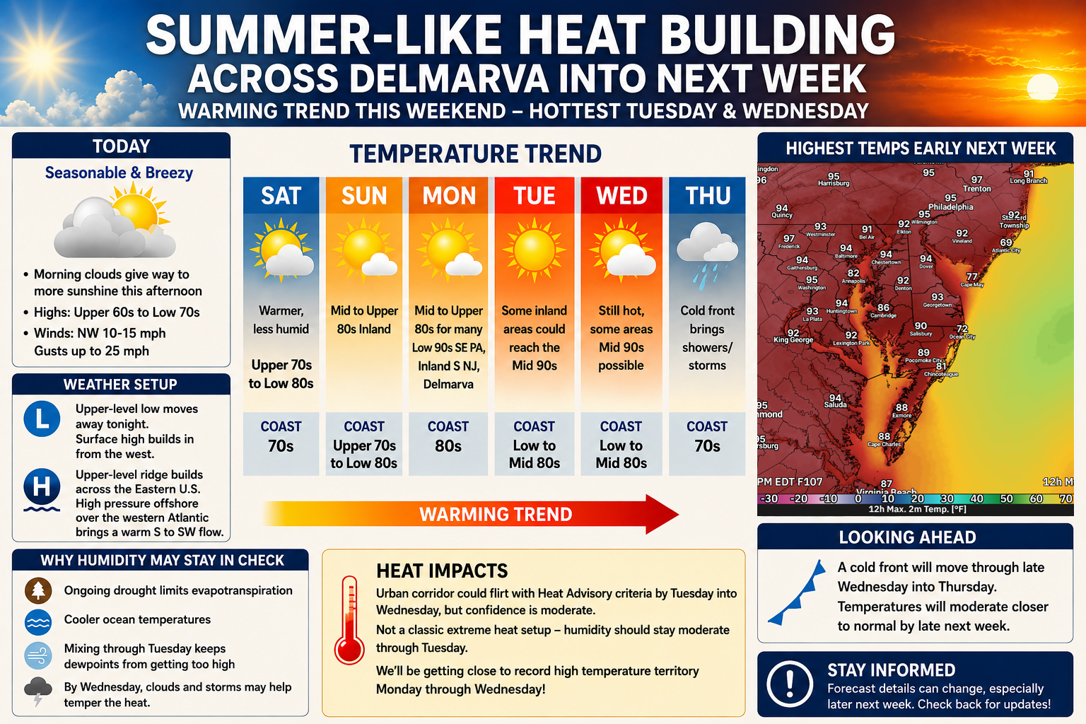

After a stretch of seasonable and breezy conditions to close out the workweek, a significant warm up is on the way for the Delmarva region as an expanding ridge of high pressure ushers in the first widespread taste of summer-like heat heading into next week.
Clouds will linger through much of today as an upper-level low pressure system slowly pulls away from the Mid-Atlantic. However, increasing sunshine is expected later this afternoon as surface high pressure begins to build into the region. Temperatures today will remain relatively comfortable for mid-May standards, with highs generally ranging from the upper 60s to lower 70s accompanied by northwest winds of 10 to 15 mph and gusts up to 25 mph.
The overall weather pattern will undergo a major transition this weekend as a strong upper-level ridge strengthens across the eastern United States. At the same time, high pressure anchored offshore over the western Atlantic will establish a persistent south to southwesterly flow across the Mid-Atlantic and Delmarva Peninsula. This setup will allow progressively warmer air to surge northward through at least the middle of next week.
Temperatures Saturday will begin climbing back above normal with highs reaching the upper 70s to lower 80s inland, though coastal communities will remain several degrees cooler thanks to the influence of chilly ocean waters.
By Sunday, much of inland Delmarva could rise into the mid to upper 80s while beach areas remain closer to the upper 70s or lower 80s. The warming trend intensifies further Monday as many communities across Delmarva push into the upper 80s to lower 90s.

Forecast guidance suggests Tuesday and potentially Wednesday may bring the hottest temperatures of the stretch. Some inland areas across Delmarva, southern New Jersey, and eastern Pennsylvania could climb into the middle 90s if sunshine remains dominant. Confidence in exact temperatures later next week remains somewhat lower, especially as clouds and possible thunderstorms approach with an eventual cold front.
Despite the increasing heat, forecasters note this setup currently does not appear especially favorable for oppressive humidity levels. Dry ground conditions associated with ongoing drought concerns across parts of the Mid-Atlantic may limit evapotranspiration, while cooler ocean temperatures should also help prevent excessive moisture from building into the atmosphere early in the week. As a result, while temperatures may approach heat advisory territory in some urban areas by Tuesday or Wednesday, the overall heat index values may remain somewhat lower than typical midsummer heat waves.
Even so, several locations could flirt with daily record high temperatures between Monday and Wednesday as this early-season heat intensifies across the region.
Relief is expected by late next week as a cold front moves through the Mid-Atlantic sometime Wednesday into Thursday, bringing temperatures back closer to seasonal averages along with the potential for scattered showers and thunderstorms.