Energy giant Chevron has halted operations at its Petronius facility in the Gulf of Mexico and evacuated all on-site workers to shore as a precaution ahead of Tropical Depression Two, the company announced Monday.
Chevron also confirmed it is removing non-essential workers from two other offshore locations — its Tubular Bells and Blind Faith platforms. The company noted that its remaining Gulf operations are continuing at normal production levels.
The tropical depression may intensify into Tropical Storm Bertha by later Monday. The National Hurricane Center has issued a tropical storm watch covering a stretch of coastline from the Ochlockonee River in Florida westward to the Jefferson/Plaquemines Parish border in Louisiana. Forecasters say the system is expected to gradually gain strength over the coming two days.
Rainfall from the storm is forecast at 2 to 4 inches along the Gulf Coast from western Florida to the Middle Texas Coast through Friday, with some isolated areas potentially seeing up to 8 inches of rain.
Consulting firm Earth Science Associates projects that roughly 2 million barrels of oil could be lost across the Gulf during the storm — a dramatic jump compared to the approximately 10,000 barrels affected by Tropical Storm Arthur last month. The firm noted that more high-output oil platforms lie in the path of this depression than in previous storms.
The Gulf of America federal offshore region produced close to 2 million barrels of crude oil daily as of March, representing about 14% of the nation’s total crude output. Shell, BP, Chevron, and Occidental Petroleum are among the leading deepwater operators in the region. The Gulf Coast’s refining corridor, stretching from Corpus Christi, Texas to Pascagoula, Mississippi, accounts for roughly half of the country’s total refining capacity of 18.4 million barrels per day.
U.S. utility CenterPoint Energy announced Monday it has activated its Emergency Operations Center in response to the approaching storm. CenterPoint Resilience VP Nathan Brownell said in a statement: “With the storm forecast to reach Greater Houston by Friday, if any weather-related outages occur, our crews will be ready to respond and restore power safely and as quickly as possible.”
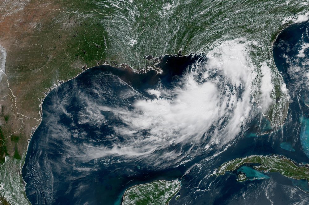
NEW ORLEANS (AP) — A tropical depression moving unpredictably across the northern Gulf of Mexico is forecast to intensify later Monday, bringing heavy rainfall capable of causing flooding and strong winds that could knock down trees and knock out power across multiple states this week.
As of the latest update, the storm system was positioned approximately 110 miles south of Panama City, Florida, carrying sustained winds of 35 mph. The U.S. National Hurricane Center, based in Miami, said the depression is on track to gradually gain strength and reach tropical storm classification by the end of the day Monday.
The system has been drifting in a northwesterly direction at roughly 3 mph and is expected to approach and travel along the northern Gulf Coast over the coming days. In response, officials have issued a storm surge watch stretching from the mouth of the Mississippi River eastward to the Alabama-Florida border along the Gulf.
A tropical storm watch has also been put in place from the Ochlockonee River in Florida westward into southeastern Louisiana, reaching to the Jefferson and Plaquemines parish line.
The National Weather Service office in New Orleans cautioned that dangerous storm conditions could develop from the Florida Panhandle westward into Louisiana as early as Tuesday. Forecasters warned of wind gusts reaching 40 mph and flagged a potentially “life threatening” storm surge situation for the coastlines of Alabama, Mississippi, and southeastern Louisiana.
The hurricane center warned that storm surges of up to four feet could impact parts of the Louisiana and Mississippi shorelines. Forecasters also noted the possibility of an isolated tornado or two in the Florida Big Bend area during the week.
Flash flooding is expected to remain a concern through Friday along the coast, from western Florida to middle Texas. Rainfall totals of 3 to 5 inches are anticipated along the Louisiana coastline, with even higher amounts possible in some locations, particularly south of Lake Pontchartrain, according to the weather service.
Elsewhere, in the eastern Pacific Ocean, Tropical Storm Fausto continued to gain strength Monday and was approaching hurricane strength far from the Mexican coastline. Fausto was packing sustained winds of 65 mph and was located about 775 miles southwest of the southern tip of Mexico’s Baja California Peninsula. The storm was tracking west-northwest at 13 mph and posed no threat to any land areas, the hurricane center said.
A Flood Watch has been issued by the National Weather Service office in Mount Holly, New Jersey, effective from Sunday, July 20 at 2:44 PM Eastern Time through Tuesday, July 22 at 2:00 AM Eastern Time.
A Flood Watch means that conditions are favorable for flooding to develop in the affected area. Residents are urged to stay informed, avoid low-lying areas prone to flooding, and be ready to act quickly if flooding begins.
Officials recommend that people have an emergency plan in place, keep important documents in a safe location, and never attempt to drive through flooded roadways. Remember: turn around, don’t drown.
TV Delmarva will continue to monitor this weather alert and provide updates as conditions develop. Check back for the latest information from the National Weather Service.
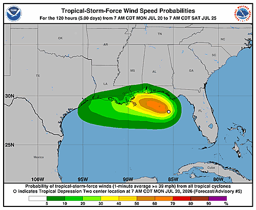
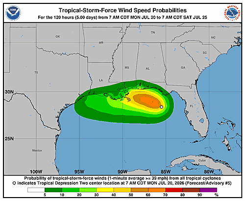
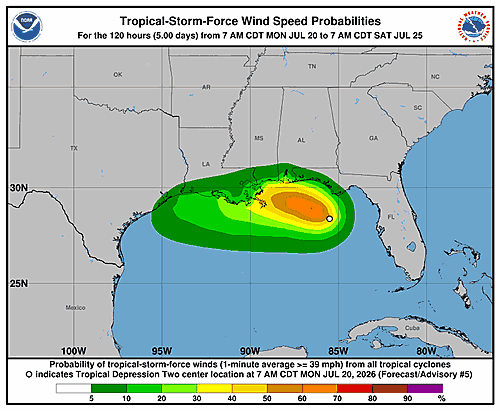
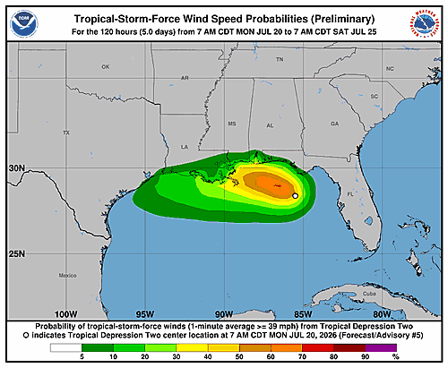
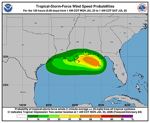
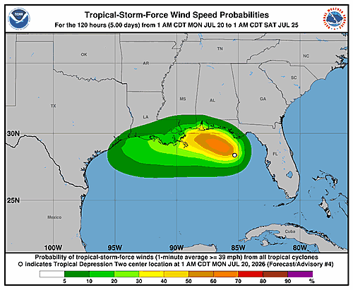
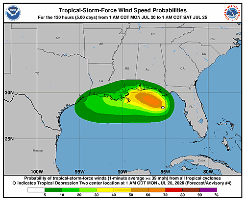
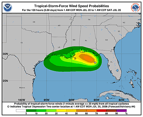
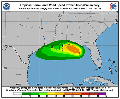
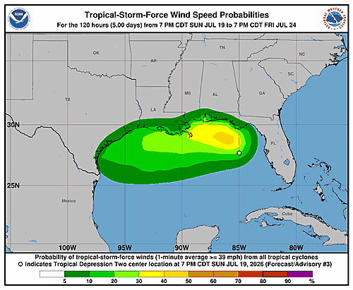
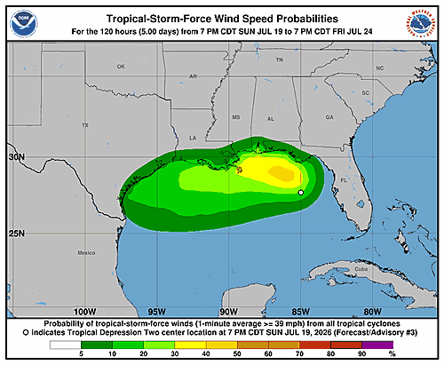
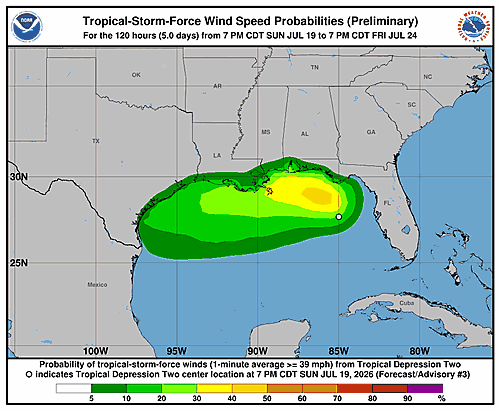
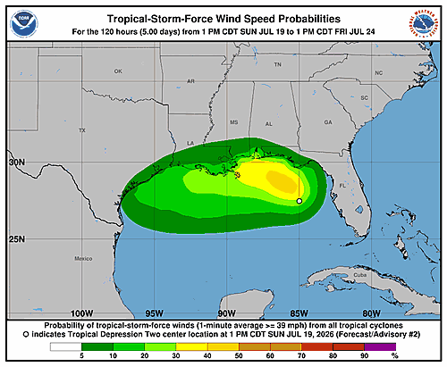
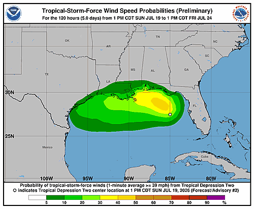
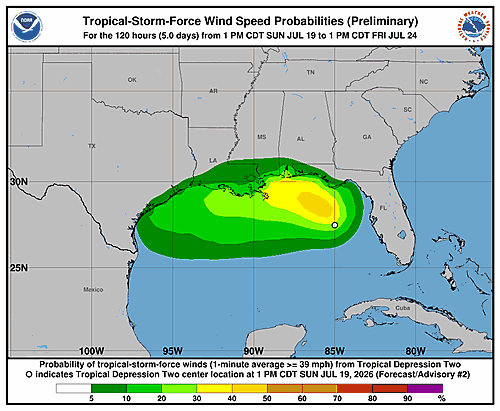
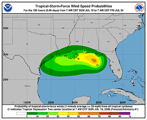
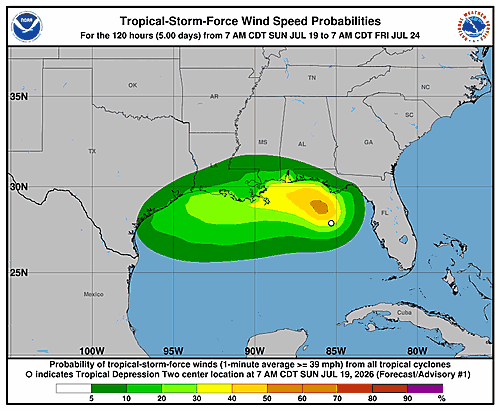
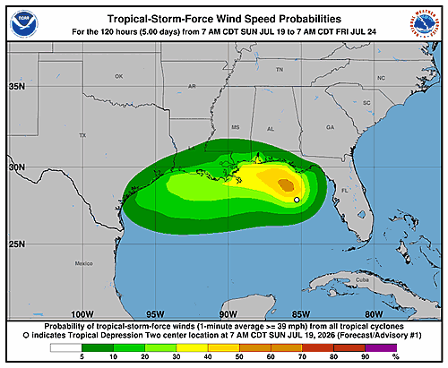
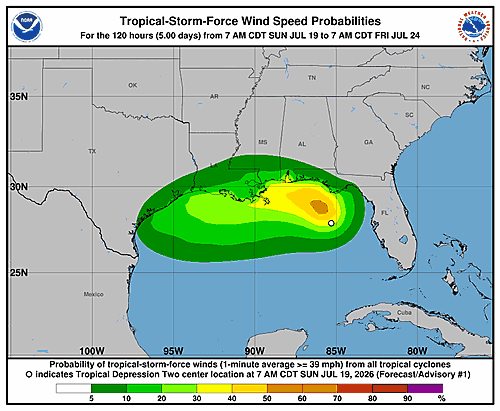
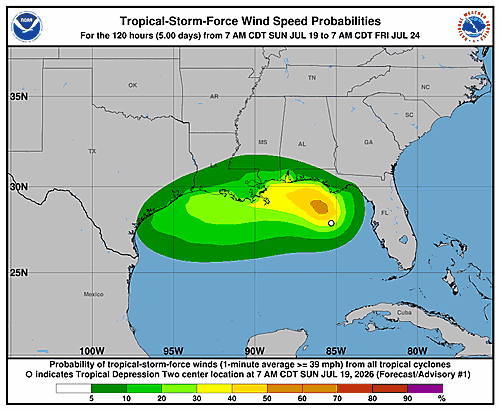
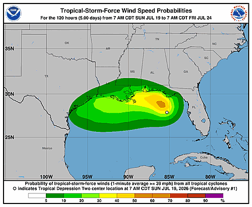
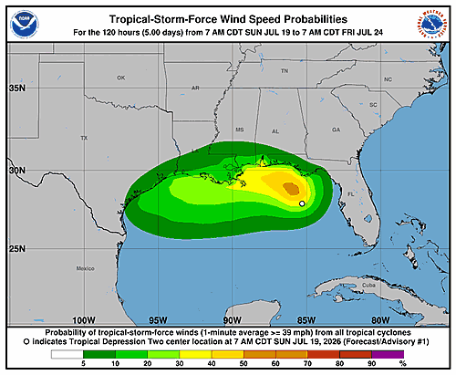
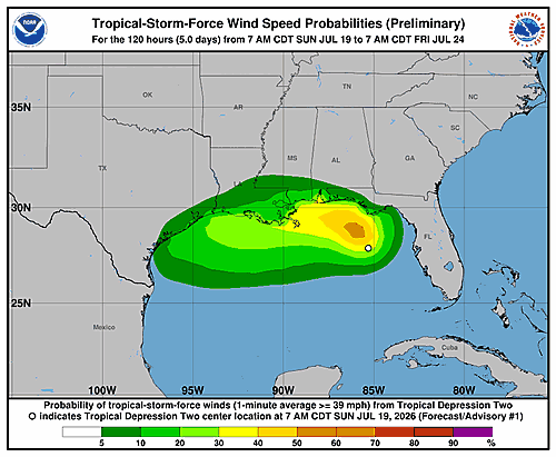
The National Hurricane Center is keeping a close eye on Tropical Depression Two, releasing updated wind speed probability graphics for the Atlantic storm system.
According to the NHC, the latest 34-knot wind speed probability forecast covers a 120-hour outlook period. The graphics were last updated on Monday, July 20, 2026, at 15:22 GMT.
Residents in potentially affected areas are encouraged to monitor the latest updates from the National Hurricane Center as forecasters continue to track the storm’s development and movement.
The National Hurricane Center has issued an updated Potential Storm Surge Flooding Map for Tropical Depression Two, with the most recent update recorded on Monday, July 20, 2026, at 4:01 PM GMT.
Storm surge flooding maps are used to help residents and emergency officials understand which areas could be at risk of inundation from a tropical system. Residents in potentially affected coastal areas are encouraged to stay informed and follow guidance from local emergency management authorities.
For the most current information on Tropical Depression Two and associated storm surge risks, residents should monitor updates from the National Hurricane Center.
The National Hurricane Center has released an updated Storm Surge Watch/Warning Map for Tropical Depression Two, with the most recent update recorded at 14:51 GMT on Monday, July 20, 2026.
The map outlines areas currently under storm surge watches and warnings associated with the tropical system. Coastal residents and those in low-lying areas are encouraged to stay informed and follow guidance from local emergency management officials.
Storm surge can pose a serious and life-threatening risk, pushing large volumes of water inland and causing significant flooding in coastal communities. Monitoring updates from the National Hurricane Center is strongly advised as the storm system continues to develop.
A tropical depression is on the move in the Atlantic, and forecasters say it could reach tropical storm strength before the day is done.
As of 1:00 PM CDT on Monday, July 20, the center of Tropical Depression Two was positioned near latitude 28.6 North, longitude 85.6 West. The system was drifting in an erratic northwestward direction at just 3 miles per hour.
The depression had maximum sustained winds of approximately 35 mph and a minimum central pressure of 1005 millibars at the time of the report.
Forecasters are expecting the system to organize further and develop into a tropical storm either this afternoon or tonight. Residents along coastal areas should continue monitoring updates from the National Hurricane Center as the storm’s path and intensity evolve.
The National Hurricane Center has issued updated wind speed probability information for Tropical Depression Two, the second named tropical system of the Atlantic season.
According to the latest graphics released by forecasters, the probability map tracks the chances of 34-knot wind speeds affecting various areas over a 120-hour forecast window.
The wind speed probability data was last updated on Monday, July 20, 2026, at 15:22 GMT. Residents in potentially affected coastal areas are encouraged to monitor the latest updates from the National Hurricane Center as the storm system continues to be tracked.
The National Hurricane Center has issued an updated potential storm surge flooding map for Tropical Depression Two, with the latest revision posted on Monday, July 20, 2026, at 4:01 PM GMT.
Storm surge flooding maps are used to help coastal residents and emergency managers understand which areas may be at risk of inundation if a tropical system makes landfall or moves close to shore.
Residents in areas that could be affected by Tropical Depression Two are encouraged to monitor updates from the National Hurricane Center and follow guidance from local emergency management officials.
The National Hurricane Center has released an updated storm surge watch and warning map for Tropical Depression Two, with the most recent update posted on Monday, July 20, 2026.
Storm surge watches and warnings are issued to alert coastal communities of the potential for dangerous and life-threatening flooding caused by rising ocean waters pushed ashore by a tropical system.
Residents in areas under a storm surge watch or warning are urged to follow guidance from local emergency management officials and stay informed through official National Hurricane Center updates.
The National Hurricane Center has issued an updated potential storm surge flooding map for Tropical Depression Two, with the most recent update recorded on Monday, July 20, 2026, at 4:01 PM GMT.
Storm surge flooding maps are used to help residents and emergency managers understand which areas could be at risk of inundation if a tropical system makes landfall or passes nearby. Officials encourage those in potentially affected coastal areas to stay informed and follow guidance from local emergency management authorities.
Residents are urged to check the latest updates from the National Hurricane Center as the storm system continues to be monitored.
Tropical Depression Two is showing signs of increased organization as it churns through the Gulf of Mexico, prompting officials to issue new tropical watches for portions of the Gulf Coast.
According to the National Hurricane Center, as of 10:00 AM CDT on Monday, July 20, the center of the storm was positioned near latitude 28.5 North, longitude 85.6 West. The depression was moving to the northwest at a slow pace of just 3 miles per hour.
The storm’s minimum central pressure was recorded at 1007 millibars, with maximum sustained winds of approximately 35 miles per hour.
Forecasters are urging residents along the Gulf Coast to stay informed as the system continues to develop. New watches have been issued for portions of the region as the depression shows potential for further strengthening.
The National Hurricane Center in Miami issued its fifth forecast advisory for Tropical Depression Two on Monday afternoon, placing the storm’s center near 28.5 degrees north latitude and 85.6 degrees west longitude as of 3:00 p.m. UTC on July 20, 2026.
The depression was moving toward the northwest at just 3 knots — roughly 3.5 miles per hour — a very slow pace. The storm’s position is considered accurate within 30 nautical miles. Its minimum central pressure was recorded at 1007 millibars, with maximum sustained winds of 30 knots and gusts reaching up to 40 knots.
Looking ahead, forecasters expect the system to gradually strengthen over the next several days. By Tuesday morning, maximum winds are projected to reach 35 knots, climbing to 40 knots by Tuesday evening and 45 knots by Wednesday morning. The storm is expected to maintain that intensity through Wednesday afternoon before beginning to weaken slightly as it approaches and moves inland.
According to the forecast track, the depression is expected to move inland sometime around Wednesday night into Thursday morning, near the 29.5 degrees north, 90.8 degrees west area. After landfall, winds are forecast to ease to 35 knots by Thursday morning.
The extended outlook shows the system continuing inland, with winds dropping to 30 knots by Friday and further weakening to 25 knots by Saturday as it pushes deeper over land.
Forecasters noted that track errors on extended outlooks average around 125 nautical miles on day four and 175 nautical miles on day five, with intensity errors averaging about 15 knots per day. The next advisory was scheduled for 9:00 p.m. UTC Monday. The forecast was issued by forecaster Beven.
The National Hurricane Center has released updated wind speed probability graphics for Tropical Depression Two, offering the latest look at where the storm could bring dangerous wind conditions.
The graphics, which track the probability of 34-knot wind speeds over a 120-hour period, were last updated on Monday, July 20, 2026, at 15:22 GMT.
Residents and mariners in potentially affected areas are encouraged to monitor the latest forecasts from the National Hurricane Center as the storm continues to develop.
The National Hurricane Center has issued an updated Storm Surge Watch/Warning Map for Tropical Depression Two, with the most recent update recorded on Monday, July 20, 2026, at 14:51 GMT.
The map outlines areas currently under storm surge watches and warnings as the tropical depression continues to be monitored. Coastal residents in affected zones are encouraged to stay informed and follow guidance from local emergency management officials.
Storm surge can pose a serious threat to life and property in low-lying coastal areas. Residents should continue checking for updates from the National Hurricane Center as conditions develop.
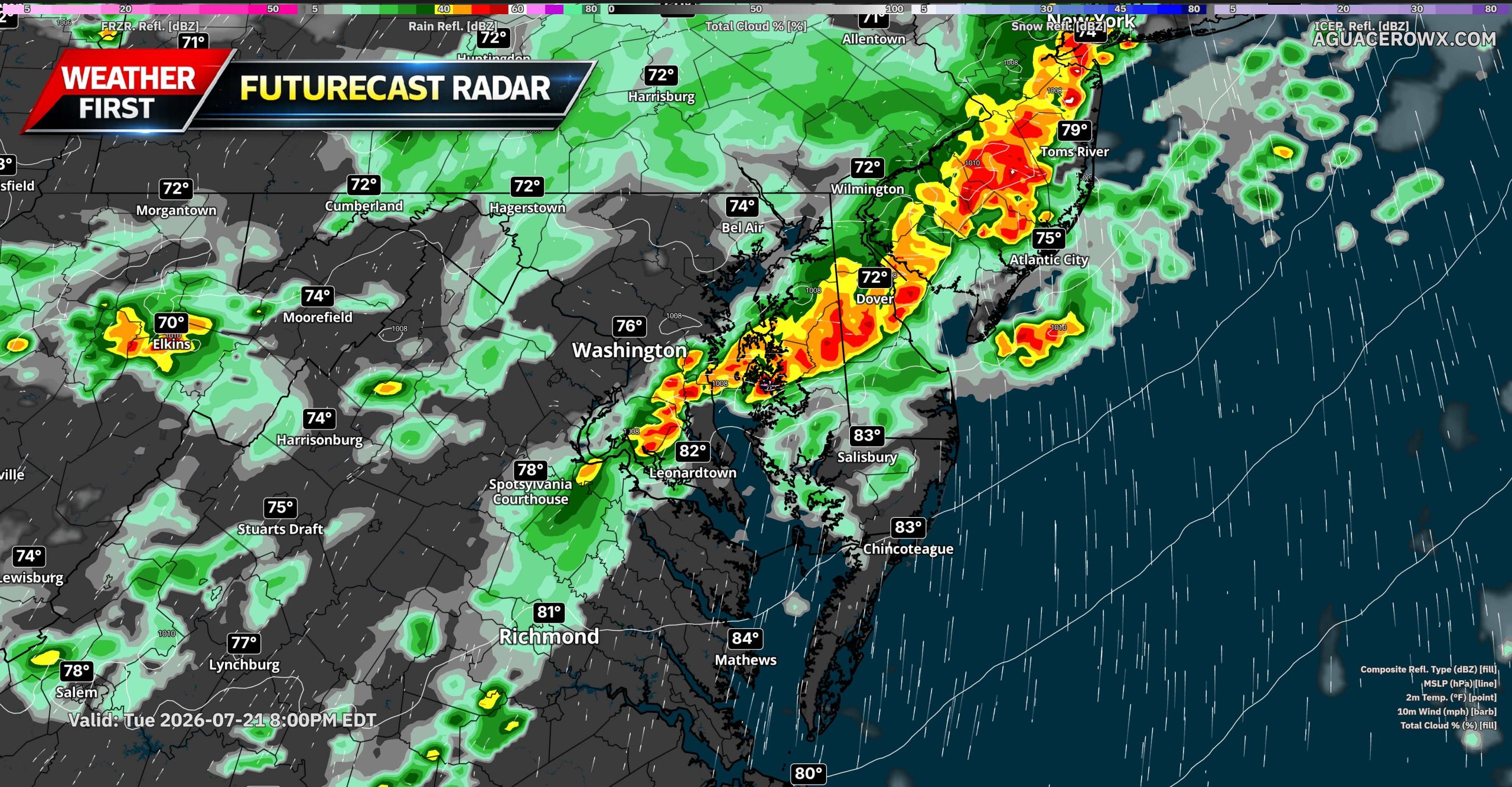
The combination of a strong cold front and an unusually moisture-rich atmosphere will create a threat for torrential rainfall and localized flash flooding across portions of the Mid-Atlantic on Tuesday and Wednesday.
The flood threat will initially cover a broad area Tuesday, July 21, before shifting south toward Virginia and North Carolina on Wednesday, July 22. While not every community will experience flooding, thunderstorms will be capable of producing extremely heavy rainfall over a short period.
Widespread Thunderstorms Expected Tuesday
A strong cold front moving south and east from the Midwest will encounter tropical moisture being transported northward from Tropical Depression Two over the Gulf. The tropical system itself will remain far from the Mid-Atlantic, but its moisture will become incorporated into the larger weather pattern affecting the eastern United States.
Atmospheric moisture values, known as precipitable water or PWATs, are expected to exceed 2 inches across much of the region. Some locations could briefly experience values above 2.25 inches. Those levels indicate an unusually deep supply of moisture available for thunderstorms to convert into heavy rainfall.
Numerous thunderstorm segments are expected to develop along and ahead of the front Tuesday. Heavy rainfall could affect areas from the central and northern Appalachian Mountains eastward toward the Interstate 95 corridor, including locations from Richmond through Washington, Baltimore, Philadelphia, New York City and Boston.
Most storms should move relatively quickly, which may prevent widespread flooding in many communities. The faster storm movement also means damaging winds could become the more immediate concern with some of the thunderstorms.
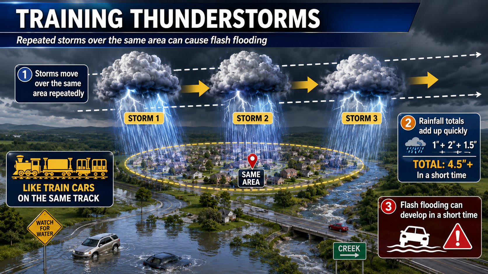
However, the flash-flood threat will increase wherever storms repeatedly track over the same locations.
Training Storms Could Produce Localized Flooding
Thunderstorms sometimes develop or move repeatedly along the same boundary, creating a pattern known as training. Similar to train cars traveling along the same track, multiple storms can pass over one community while nearby locations receive considerably less rain.
Backbuilding is another concern. This occurs when new thunderstorms continuously develop along the rear edge of an existing line, allowing heavy rainfall to persist over one area even while individual storm cells are moving.
Training or backbuilding storms could produce several inches of rain in a short period Tuesday. The greatest concerns will include urban areas, poor-drainage locations, low-lying roads and communities near smaller streams and creeks.
A Level 2 out of 4 Slight Risk for excessive rainfall remains in place across much of the Mid-Atlantic for Tuesday. This category indicates that scattered or widely separated episodes of flash flooding will be possible.
For Delmarva, the flood risk will depend heavily on the exact placement and movement of thunderstorm clusters. Storms that remain progressive may primarily produce strong winds and brief heavy rain. However, any slowdown or repeated movement over the same communities could quickly result in flooded roads and drainage problems.
Flood Threat Shifts South Wednesday
The cold front responsible for Tuesday’s storms is expected to slow and stall across central Virginia on Wednesday.
Abundant Gulf moisture will continue flowing northeastward ahead of the boundary. PWAT values could once again rise above 2.25 inches across portions of the Carolinas and southeastern Virginia.
Unlike Tuesday, when many storms should remain relatively fast-moving, the stalled front could act as a track for repeated rounds of thunderstorms Wednesday. The interaction between the boundary and the deepest tropical moisture may promote numerous training and backbuilding storms.
The greatest Wednesday concern currently extends from central North Carolina northeastward through northeastern North Carolina and the Tidewater region of Virginia. A higher-end Slight Risk remains in place across this area.
Forecast trends will be monitored closely because an upgrade to a Level 3 out of 4 Moderate Risk remains possible. Such an upgrade would indicate a more concentrated potential for numerous or significant flash-flooding incidents.
Areas farther north across the Mid-Atlantic may experience a lower flood threat Wednesday as the front and deepest moisture settle southward. However, the exact location of the stalled boundary remains important and could shift as newer forecast information becomes available.
Tropical System Supplying Additional Moisture
As of Monday morning, Tropical Depression Two was moving slowly northwestward over the northeastern Gulf with maximum sustained winds near 35 mph. The system was forecast to strengthen into a tropical storm while moving near or along portions of the northern Gulf Coast.
The tropical system is not expected to move into the Mid-Atlantic. Instead, moisture circulating around it will be drawn northward and interact with the approaching cold front.
That moisture connection will help thunderstorms produce very efficient rainfall rates, particularly where storms train or repeatedly develop along the boundary.
Remain Alert for Rapidly Changing Conditions
Flash flooding can develop quickly during tropical downpours, especially at night or in locations where drainage systems become overwhelmed.
Residents should have several ways to receive weather warnings and avoid driving through flooded roads. Water depth can be difficult to judge, and roads may be damaged or completely washed away beneath the water.
Never attempt to walk or drive through a flooded roadway. Turn around and find another route.
Tuesday will bring the broader heavy-rain and severe-thunderstorm threat across the Mid-Atlantic. By Wednesday, the most concentrated flash-flood concern is expected to shift south into Virginia and North Carolina, where a stalled front could support repeated rounds of torrential thunderstorms.
A local weather statement was issued at 10:02 AM CDT for the New Orleans and Baton Rouge, Louisiana area, according to information from the National Hurricane Center.
The alert was released through official National Oceanic and Atmospheric Administration channels covering the Gulf Coast region. Residents in the affected Louisiana communities are encouraged to stay informed and follow guidance from local emergency management officials.
Further details on the nature and scope of the statement were not included in the available information. Those in the New Orleans and Baton Rouge areas should check with local authorities and weather services for the latest updates.
Tropical Depression Two is gradually becoming better organized over the Gulf of Mexico, according to a forecast discussion issued Monday morning by the National Hurricane Center in Miami.
Satellite images and surface observations show the storm’s low-level circulation is becoming more defined, with increased bands of thunderstorm activity forming near the center. However, data collected by an Air Force Reserve Hurricane Hunter aircraft and surface observations confirm the storm has not yet gained strength. The aircraft recorded maximum flight-level winds of 34 knots at 925 millibars, and the central pressure is around 1007 mb. Based on that data, the storm’s current intensity is set at 30 knots.
The center of the depression appears to have shifted slightly southward over the past several hours, though its overall movement remains toward the northwest at about 3 knots. Forecasters say the storm is caught between two mid-level high-pressure ridges — one to its northwest centered over the Rockies and another to its southeast near the Bahamas. As a large-scale weather trough moves into the northeastern United States, the ridge over the Rockies is expected to take over as the primary steering feature, gradually turning the storm toward the west-northwest and then westward at a slow pace.
The updated forecast track places the center near southeastern Louisiana in roughly 60 hours, then reaching southeastern Texas by the 120-hour mark. The track has been shifted slightly south compared to previous forecasts, partly due to the storm’s current position and the influence of northeasterly wind shear that may push the center a bit farther south.
The depression is currently dealing with moderate northeasterly wind shear, conditions forecasters expect to persist for another 24 to 30 hours. During that window, bursts of thunderstorm activity near and south of the center are likely to help the system strengthen into a tropical storm. After about 30 hours, the shear is forecast to increase significantly — strong enough to disrupt the storm’s vertical structure, halting intensification and causing some weakening. The peak intensity is forecast at 45 knots, expected between 36 and 48 hours from now, which is on the higher end of guidance models. Forecasters believe the system will survive through the 120-hour forecast period, though it could dissipate between 72 and 120 hours, particularly if it tracks north of the current forecast and encounters more land interaction.
Forecasters also note that the wind shear is likely to give the storm a lopsided structure, with the heaviest rainfall and strongest winds expected to occur south of the center.
Key Messages from the National Hurricane Center:
1. The depression is expected to gradually strengthen and could bring tropical storm conditions to portions of the Gulf Coast from the Florida Panhandle westward to southeastern Louisiana beginning late Monday night into Tuesday.
2. A Storm Surge Watch has been issued for the Alabama, Mississippi, and southeastern Louisiana coasts, where a life-threatening storm surge is possible.
3. Interests elsewhere in Louisiana and Texas should monitor the progress of this system, as additional watches could be required for portions of those areas later Monday or Tuesday.
4. Flash flooding will be possible through Friday along the Gulf Coast and nearby inland areas from western Florida to the middle Texas Coast, including southern portions of Alabama, Mississippi, and Louisiana.
The forecast was prepared by Forecaster Beven at the National Hurricane Center.
The National Hurricane Center in Miami released its fifth wind speed probability bulletin for Tropical Depression Two at 11:00 a.m. Eastern Daylight Time on Monday, July 20, 2026.
At the time of the report, the center of the tropical depression was located near latitude 28.5 degrees North and longitude 85.6 degrees West, with maximum sustained winds of approximately 30 knots — equal to 35 miles per hour or 55 kilometers per hour.
The bulletin provided a five-day outlook showing the probability of sustained winds reaching tropical storm force (39 mph), 50-knot force (58 mph), and hurricane force (74 mph) at specific locations along the Gulf Coast.
Among the areas with the highest cumulative probabilities of experiencing at least tropical storm-force winds over the five-day period were locations near longitude 87.0 degrees West at latitude 29.0 degrees North, where the cumulative probability reached 66 percent. Panama City, Florida, showed a cumulative probability of 14 percent, while Apalachicola, Florida, carried an 8 percent cumulative chance.
Further west, New Orleans, Louisiana, carried an 8 percent cumulative probability, and Buras, Louisiana, showed a 14 percent cumulative chance. Locations in Texas, including Galveston, showed a 7 percent cumulative probability by the end of the five-day forecast window.
The probability table covered locations stretching from Apalachicola, Florida, westward through Alabama, Mississippi, Louisiana, and into Texas, including cities such as Mobile, Gulfport, Pensacola, Baton Rouge, Lake Charles, Cameron, Port Arthur, and Galveston.
The bulletin was issued by Forecaster Beven at the National Hurricane Center.
The National Hurricane Center has issued updated wind speed probability graphics for Tropical Depression Two, the second tropical system of the Atlantic hurricane season.
The graphics display the probability of 34-knot wind speeds associated with the storm over a 120-hour forecast period. The information was last updated on Monday, July 20, 2026, at approximately 2:49 p.m. GMT.
Residents in potentially affected coastal areas are encouraged to monitor updates from the National Hurricane Center as the storm system continues to be tracked.
The National Hurricane Center has released an updated storm surge watch and warning map for Tropical Depression Two, with the most recent update posted Monday, July 20, 2026, at 14:51 UTC.
Storm surge watches and warnings indicate the potential for dangerous and life-threatening coastal flooding in areas that could be impacted by the tropical system. Residents in affected zones are urged to pay close attention to local emergency management guidance and stay informed as the storm develops.
Officials recommend that those in watch and warning areas take any necessary precautions and be prepared to act quickly if conditions worsen. Updates to the storm surge map will continue to be issued as the situation evolves.
The National Hurricane Center has issued updated graphical information for Tropical Depression Two, tracking the system’s potential wind impacts across a 120-hour forecast window.
The graphics depict the probability of 34-knot wind speeds affecting different areas as the tropical depression continues to develop. These probability maps are a key tool used by forecasters and emergency managers to assess where tropical storm-force winds may occur.
The wind speed probability graphics were last updated Monday, July 20, 2026, at 9:22 a.m. GMT. Residents in potentially affected areas are encouraged to monitor the latest updates from the National Hurricane Center as the system evolves.
A potentially active stretch of severe weather is taking shape across the Mid-Atlantic, with the greatest concern expected Tuesday afternoon and evening before the threat shifts farther south and east on Wednesday.
The latest SPC outlook places parts of the Ohio Valley and Mid-Atlantic under a Level 3 out of 5 Enhanced Risk for severe thunderstorms Tuesday. This includes portions of West Virginia, northern Virginia, Maryland and Pennsylvania. Severe storms will also be possible across surrounding areas, including other parts of the Mid-Atlantic and Northeast.
Tuesday Brings the More Widespread Threat
Tuesday appears to have the greatest potential for numerous severe thunderstorms across the region. An upper-level trough and several smaller disturbances will move through the eastern United States while an area of low pressure tracks from southern Ontario into Quebec. A cold front will approach from the west, while a separate trough develops ahead of the front across the Mid-Atlantic.
A very warm and humid air mass will be in place ahead of these features, with dew points generally in the middle 60s to lower 70s. This moisture, combined with daytime heating, should allow moderate to strong atmospheric instability to develop. Strong winds throughout the lower and middle levels of the atmosphere will also provide enough wind shear for organized thunderstorms.
Storms could initially develop as supercells before growing into one or more organized lines or bowing segments. The primary hazard will be damaging wind gusts, with the potential for corridors of more widespread wind damage if a well-organized line develops. Large hail and a few tornadoes will also be possible, especially with any storms that remain isolated or semi-discrete.
The exact storm evolution remains uncertain. Warmer temperatures several thousand feet above the ground could limit the potential for extremely large hail, while the risk of particularly intense wind gusts will depend on whether storms can consolidate into a mature bowing line. Even with those uncertainties, the overall environment supports a broad severe weather threat Tuesday afternoon into Tuesday night.
For Delmarva and areas closer to the coast, the severity of the threat may depend on how quickly storms organize farther west and how much instability remains available as they move eastward. Residents should closely monitor later forecasts for more specific information concerning timing and storm coverage.
Threat Shifts South and East Wednesday
The severe weather risk will not completely end Tuesday night. The upper-level trough will remain over the eastern United States on Wednesday as the cold front continues moving toward the Atlantic coast.
A Level 2 out of 5 Slight Risk is currently in place for portions of southeastern Virginia and North Carolina. Isolated strong to severe storms will remain possible elsewhere from the Mid-Atlantic into New England, although the greatest Wednesday threat is expected across Virginia and North Carolina.
Moisture and instability will remain ahead of the front, while winds of approximately 30 to 40 knots through the lower and middle atmosphere should support organized storm cells and clusters. Damaging wind gusts will be the main hazard Wednesday. The threat will likely become more concentrated along and ahead of the advancing front during the afternoon and evening.
Remain Weather Aware
Tuesday currently appears to be the more significant and widespread severe weather day for the Mid-Atlantic, with damaging winds, large hail and a few tornadoes all possible. Wednesday’s threat is expected to be more isolated and focused farther south, particularly across southeastern Virginia and North Carolina.
Residents should have multiple ways to receive warnings, secure loose outdoor objects and avoid relying solely on outdoor warning sirens. Any severe thunderstorm could produce winds capable of bringing down trees and power lines.
A tropical depression churning in the Gulf of Mexico is expected to gain enough strength to be classified as a tropical storm before the day is out, forecasters say.
As of 7:00 AM Central Daylight Time on Monday, July 20, the center of Tropical Depression Two was positioned near latitude 28.6 North, longitude 85.6 West. The storm was drifting to the northwest at just 3 miles per hour.
The system’s minimum central pressure stood at 1006 millibars, with maximum sustained winds clocking in at approximately 35 mph — just below the 39 mph threshold needed to earn tropical storm status.
Air Force Hurricane Hunter aircraft are currently flying into the depression to gather real-time data on its structure and intensity.
Residents along Gulf Coast communities should monitor the latest updates from the National Hurricane Center as the storm continues to develop.
The National Hurricane Center has released updated wind speed probability graphics for Tropical Depression Two, tracking the storm system in the Atlantic basin.
The graphic shows the probability of 34-knot wind speeds over a 120-hour forecast period. The wind speed probability image was last updated on Monday, July 20, 2026, at 9:22 AM GMT.
Forecasters and residents in potentially affected coastal regions are encouraged to monitor the National Hurricane Center for the latest updates as the storm system continues to be evaluated.
The National Hurricane Center is keeping a close watch on Tropical Depression Two, releasing updated wind speed probability graphics for the storm system.
According to the latest data from the National Hurricane Center, the 34-knot wind speed probability forecast for Tropical Depression Two was last updated on Monday, July 20, 2026, at 9:22 a.m. GMT.
Residents along the Atlantic coast are encouraged to continue monitoring official National Hurricane Center forecasts as the storm system develops.
The National Hurricane Center has issued updated wind speed probability graphics for Tropical Depression Two, with the most recent data reflecting conditions as of Monday, July 20, 2026 at 9:22 AM GMT.
The graphics depict the probability of 34-knot wind speeds associated with the storm system over a 120-hour forecast period. These visuals are used to help forecasters and the public understand the potential reach of tropical storm-force winds.
Residents and boaters in areas that could be affected by this developing system are encouraged to stay informed through official National Hurricane Center updates as the storm continues to be monitored.
A tropical depression churning in the Gulf of Mexico is expected to gain enough strength to become a tropical storm before the day is out, according to the latest advisory from forecasters.
As of 4:00 AM CDT Monday, July 20, the center of Tropical Depression Two was positioned near coordinates 28.5 degrees north latitude and 85.4 degrees west longitude. The storm was tracking toward the northwest at just 3 miles per hour.
The system’s minimum central pressure was recorded at 1006 millibars, with maximum sustained winds clocking in at approximately 35 miles per hour — just below the 39 mph threshold needed for tropical storm classification.
In anticipation of the storm’s strengthening, a Tropical Storm Watch has been extended westward to the Mississippi and Alabama border, signaling that tropical storm conditions could become possible in that region.
Residents along the Gulf Coast should continue to monitor the latest updates from the National Hurricane Center as this system develops throughout the day.
The National Hurricane Center in Miami is monitoring Tropical Depression Two as it slowly churns through the Gulf of Mexico, with forecasters expecting the system to gradually intensify before moving inland along the Gulf Coast.
As of 9:00 a.m. UTC on Monday, July 20, 2026, the storm’s center was pinpointed near latitude 28.5 degrees North and longitude 85.4 degrees West. The position is considered accurate within 30 nautical miles. The depression was moving toward the northwest at just 3 knots, or roughly 3.5 miles per hour.
At the time of the advisory, the storm’s maximum sustained winds stood at 30 knots — about 35 miles per hour — with gusts reaching up to 35 knots. The minimum central pressure was recorded at 1,007 millibars.
According to the forecast from the National Hurricane Center, the system is expected to strengthen as it continues its slow northwest drift. By Monday evening, forecasters project winds could reach 35 knots with gusts up to 45 knots. By Tuesday morning, the storm may intensify further to 40 knots sustained, with gusts near 50 knots.
The system is forecast to maintain winds around 45 knots — near tropical storm strength — through Wednesday, July 22, as it approaches the Gulf Coast. By early Thursday morning, July 23, the center is expected to move inland with sustained winds still around 40 knots.
Looking further out, the extended outlook places the storm along or near the coast on July 24 with winds of 35 knots, then pushing further inland by July 25 with winds dropping to 30 knots. Forecasters caution that track errors on day four average around 125 nautical miles, and around 175 nautical miles on day five, so the exact landfall location remains uncertain.
Ships within 300 nautical miles of the storm’s center have been asked to submit reports every three hours to help meteorologists track the system. The next full advisory was scheduled for 3:00 p.m. UTC Monday. This advisory was issued by Forecaster Papin.
A tropical depression churning in the Gulf of Mexico is showing limited organization on satellite imagery Monday morning, with only scattered pockets of deep thunderstorm activity surrounding its circulation center. However, an Air Force Reserve reconnaissance aircraft flying through the system found that pressure continues to slowly drop, with a peak flight-level wind reading of 38 knots at 925 millibars — data that prompted forecasters to nudge the storm’s maximum winds up slightly to 30 knots in the latest advisory.
Tracking data shows the depression drifting slowly toward the northwest at about 3 knots. The system is currently caught between two mid-level high-pressure ridges — one positioned over the Rocky Mountains to its northwest and another near the Bahamas to its southeast. Forecasters expect the Rocky Mountain ridge to take over as the primary steering influence as a large weather trough moves into the northeastern United States later this week. That shift is expected to push the storm on a more west-northwest and then westward path, bringing it near or along the Gulf Coast and approaching the mouth of the Mississippi River within 72 hours. This week’s forecast track has shifted slightly northward compared to previous guidance, and the National Hurricane Center adjusted its projected path accordingly, blending two forecast models — the TVCN consensus tool and the Google DeepMind guidance system.
Forecasters say the storm’s wide, disorganized structure and dry air at mid-levels are keeping thunderstorm activity in check, resulting in only gradual strengthening. The depression is expected to reach tropical storm status later today and continue to slowly gain strength while wind shear stays low to moderate. After about 36 hours, increasing northeasterly wind shear is expected to put a stop to further intensification. With the northward track shift, land interaction becomes a more significant factor beyond 60 hours, and the latest National Hurricane Center forecast now shows the system gradually weakening after that point. Notably, the latest Google DeepMind ensemble forecast only extends the storm’s track to 72 hours, suggesting most of its computer model runs expect the system to fall apart beyond that timeframe. The intensity forecast has been lowered slightly after 72 hours compared to the previous cycle, though additional adjustments may be necessary if more guidance points to the storm moving further inland.
Key Messages from the National Hurricane Center:
Tropical storm conditions could affect parts of the Florida Panhandle and the Alabama coast beginning tonight into Tuesday. A Tropical Storm Watch is currently in effect for those areas.
Residents in Mississippi, Louisiana, and Texas should keep a close eye on this storm’s progress, as additional watches may be issued for parts of those states within the next day or two.
Flash flooding will be a threat through Friday along the Gulf Coast and nearby inland areas, stretching from western Florida all the way to the Middle Texas Coast — including southern portions of Alabama, Mississippi, and Louisiana.
This forecast was issued by Forecaster Papin at the National Hurricane Center.
The National Hurricane Center in Miami issued its fourth wind speed probability advisory for Tropical Depression Two at 9:00 a.m. Coordinated Universal Time on Monday, July 20, 2026.
At the time of the advisory, the center of the storm was positioned near latitude 28.5 degrees North and longitude 85.4 degrees West, with maximum sustained winds of approximately 30 knots — equal to about 35 miles per hour or 55 kilometers per hour.
The advisory outlines the likelihood of sustained wind speeds reaching three thresholds — 39 mph, 58 mph, and 74 mph — at specific locations along the Gulf Coast over the coming five days.
Among the areas with the highest cumulative probabilities of experiencing tropical storm-force winds of at least 39 mph are locations near the central Gulf, with some grid points showing cumulative probabilities exceeding 60 percent. The Florida Panhandle communities of Apalachicola and Panama City carry cumulative probabilities in the range of 13 to 18 percent over the five-day period.
Further west, locations in Louisiana — including New Orleans, Baton Rouge, Houma, Morgan City, and Cameron — show increasing probabilities as the forecast period extends into Wednesday and Thursday. Cameron, Louisiana carries one of the higher cumulative probabilities among named locations at 16 percent by the end of the five-day window.
Texas coastal communities including Galveston, Port Arthur, High Island, and Matagorda also appear in the probability tables, with Galveston showing a cumulative probability of 10 percent for tropical storm-force winds by the end of the forecast period.
Probabilities for stronger winds of 58 mph or greater remain limited, with only a handful of open-water grid points showing any meaningful chance of those thresholds being reached.
This advisory was prepared by forecaster Papin at the National Hurricane Center.
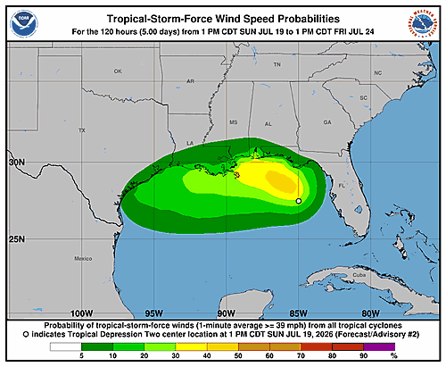
The National Hurricane Center has released wind speed probability graphics for Tropical Depression Two, an Atlantic storm system currently being tracked by forecasters.
The graphics, which display the probability of 34-knot wind speeds over a 120-hour period, were last updated on Monday, July 20, 2026, at approximately 8:52 a.m. GMT.
Residents along the East Coast, including the Delmarva Peninsula, are encouraged to monitor updates from the National Hurricane Center as the storm system develops.
The National Hurricane Center has issued updated wind speed probability information for Tropical Depression Two, the second named Atlantic tropical system of the 2026 hurricane season.
The latest graphic, updated on Monday, July 20, 2026, at approximately 3:22 a.m. GMT, illustrates the probability of 34-knot wind speeds associated with the storm over a 120-hour forecast period.
Forecasters are continuing to track the system, and residents in potentially impacted areas are encouraged to stay informed through the latest official advisories as conditions may change.
Tropical Depression Two remained on the move early Monday morning, slowly drifting in a north-northwestward direction across the Gulf of Mexico.
According to the latest advisory issued at 1:00 AM CDT on Monday, July 20, the center of the depression was positioned near latitude 28.4 north and longitude 85.3 west. The system was moving at a sluggish pace of just 3 miles per hour.
Forecasters measured the storm’s minimum central pressure at 1007 millibars, with maximum sustained winds clocking in at approximately 30 miles per hour — keeping the system at tropical depression strength.
Residents in coastal areas near the Gulf should continue to monitor updates from weather officials as the storm’s track and intensity could change in the coming hours.
The National Hurricane Center has released updated wind speed probability graphics for Tropical Depression Two, tracking the system’s potential impact on areas within its projected path.
The graphics, which display the probability of 34-knot wind speeds over a 120-hour period, were last updated on Monday, July 20, 2026, at 3:22 a.m. GMT.
Residents are encouraged to continue monitoring official National Hurricane Center forecasts as the system develops and forecasters gain a clearer picture of its track and intensity.
The National Hurricane Center has issued updated wind speed probability graphics for Tropical Depression Two, with the most recent data reflecting conditions as of Monday, July 20, 2026, at 3:22 a.m. GMT.
The graphic released by forecasters displays the probability of 34-knot wind speeds associated with the storm over a 120-hour forecast period. These visuals are used to help residents and emergency managers understand where tropical-force winds may be felt as the system develops.
Anyone in or near potentially affected coastal regions is encouraged to keep a close eye on updates from the National Hurricane Center as the storm continues to be monitored.
A tropical depression churning in the Gulf of Mexico is gradually making its way toward the Florida Panhandle, and forecasters say tropical storm conditions could arrive in that region by late Monday.
According to the National Hurricane Center, as of 10:00 PM CDT on Sunday, July 19, the center of Tropical Depression Two was positioned near latitude 28.0 North, longitude 85.1 West. The storm was moving north-northwestward at just 3 miles per hour — a very slow pace.
The system’s minimum central pressure was recorded at 1008 millibars, with maximum sustained winds of approximately 30 miles per hour. While not yet a tropical storm, forecasters are watching the system closely as it edges toward the Gulf Coast.
Residents in the Florida Panhandle area are advised to keep a close eye on updates from the National Hurricane Center as the storm continues its slow northward crawl.
The National Hurricane Center in Miami is closely monitoring Tropical Depression Two, issuing its third forecast discussion late Sunday night as the storm slowly churns in the Gulf of Mexico.
As of 10:00 PM CDT Sunday, July 19, 2026, the depression is generating a small cluster of deep thunderstorm activity near and just north of its center, with additional rain bands developing mainly in its eastern half. Satellite data and nearby surface weather observations have shown wind speeds no greater than about 20 knots, so forecasters are holding the storm’s initial intensity at 25 knots, or about 30 miles per hour — a figure also supported by a recent scatterometer pass.
The storm is drifting slowly toward the north-northwest, caught between a high-pressure ridge over the western Atlantic and another over the south-central United States. Most weather models indicate this sluggish movement will continue into early this week, with a gradual shift toward the west-northwest. Outer rain bands from the system could begin bringing tropical storm conditions to parts of the Florida Panhandle as early as late Monday, where a Tropical Storm Watch is already in effect.
By late Tuesday, forecasters expect the storm to turn more westward and pick up forward speed as the ridge over the United States expands eastward. This would push the system along or just off the northwestern Gulf Coast through the middle and latter part of the week.
In terms of strength, only gradual intensification is anticipated. The storm’s broad structure, pockets of dry air at mid-levels, and northeasterly wind shear are limiting its ability to organize — even though it is moving over very warm water. The system is still projected to reach tropical storm status on Monday while positioned offshore of the Florida Panhandle. However, an increase in wind shear expected by Tuesday, combined with some land interaction, could stall any further strengthening.
Forecaster Blake acknowledged significant uncertainty in the intensity outlook, noting that weather models are producing a wide range of outcomes — from near dissipation according to some European and HAFS model guidance, to near hurricane strength in the latest HWRF and HMON model runs. The NHC forecast falls between those extremes, though the forecaster stated plainly: “I don’t have much confidence in this prediction given the above factors.”
Key messages from the National Hurricane Center include:
1. Tropical storm conditions could reach parts of the Florida Panhandle beginning late Monday, where a Tropical Storm Watch is in effect.
2. Residents in Alabama, Mississippi, Louisiana, and Texas should follow the storm’s progress, as watches may be issued for some of those areas within the next day or two.
3. Flash flooding will be possible through Thursday along the eastern and central Gulf Coast, from western Florida through southern portions of Alabama, Mississippi, and Louisiana.
The National Hurricane Center in Miami issued its third wind speed probability advisory for Tropical Depression Two at 3:00 a.m. Coordinated Universal Time on Monday, July 20, 2026.
At the time of the advisory, the center of Tropical Depression Two was positioned near latitude 28.0 North and longitude 85.1 West. The storm’s maximum sustained winds were recorded at approximately 25 knots — equivalent to 30 miles per hour or 45 kilometers per hour.
The advisory outlines the probability of sustained wind speeds reaching specific thresholds at various locations over the next five days. Those thresholds are 34 knots (39 mph), 50 knots (58 mph), and 64 knots (74 mph).
Among the locations with the highest cumulative five-day probabilities for tropical-storm-force winds of at least 34 knots are several Gulf Coast communities. A grid point near 29.0 North, 87.0 West carries a cumulative 47 percent chance of reaching 34-knot winds. Cameron, Louisiana shows a 20 percent cumulative chance, while Galveston, Texas carries a 19 percent cumulative probability. Buras, Louisiana stands at 14 percent, and Matagorda, Texas is listed at 15 percent.
For higher-end winds of 50 knots or more, probabilities remain low but are not zero. The grid point near 29.0 North, 87.0 West carries a 9 percent cumulative chance of reaching 50-knot winds. Galveston, Texas has a 4 percent cumulative probability at that threshold.
Hurricane-force winds of 64 knots or greater carry very small but noted probabilities at a few locations, including the grid point near 29.0 North, 87.0 West and Cameron, Louisiana, each at a 2 percent and 1 percent cumulative chance respectively.
Apalachicola, Florida carries a 17 percent cumulative five-day chance of tropical-storm-force winds. Panama City, Florida is listed at 20 percent, while Pensacola, Florida shows a 6 percent cumulative probability.
Further west along the Gulf Coast, New Orleans, Louisiana has a 7 percent cumulative chance, Houma, Louisiana sits at 11 percent, and Baton Rouge, Louisiana is listed at 4 percent. Lake Charles, Louisiana carries a 5 percent cumulative probability, and Port Arthur, Texas is at 6 percent.
The advisory was prepared by forecaster Blake. Probabilities listed as “X” indicate a chance of less than 1 percent.
The National Hurricane Center has issued updated wind speed probability graphics for Tropical Depression Two, providing forecasters and the public with the latest information on the storm’s potential reach.
The graphics depict the probability of 34-knot wind speeds affecting different regions over a 120-hour forecast window. This type of information helps coastal communities and emergency managers assess potential storm impacts in advance.
According to the National Hurricane Center, the wind speed probability data was last updated on Monday, July 20, 2026, at approximately 2:50 a.m. GMT. Residents in potentially affected areas are encouraged to monitor the latest updates from the National Hurricane Center as the storm system continues to develop.
The National Hurricane Center in Miami issued its third forecast advisory for Tropical Depression Two at 3:00 a.m. UTC on Monday, July 20, 2026, tracking the slow-moving storm over the Gulf of Mexico.
As of the advisory, the center of the depression was located near latitude 28.0 North, longitude 85.1 West. Forecasters say the position is accurate within about 30 nautical miles. The storm is drifting toward the north-northwest — roughly 335 degrees — at just 3 knots, making it an extremely slow-moving system.
Current maximum sustained winds stand at 25 knots, with gusts reaching up to 35 knots. The storm’s minimum central pressure is estimated at 1008 millibars.
Looking ahead, forecasters expect the depression to gradually strengthen. By Tuesday morning, July 21, winds could reach 35 knots with gusts up to 45 knots — potentially pushing the system to tropical storm status. By Wednesday, July 22, maximum winds are projected to climb to 45 knots with gusts near 55 knots.
The extended outlook through July 25 shows the storm tracking westward and eventually moving inland, with winds expected to drop back to around 30 knots as it pushes onshore.
Forecasters caution that track errors on day four average around 125 nautical miles and roughly 175 nautical miles on day five, with intensity estimates carrying an average error of about 15 knots per day. Mariners within 300 miles of the storm’s center are being asked to submit reports every three hours.
The next advisory was scheduled for 9:00 a.m. UTC Monday. The forecast was issued by Forecaster Blake.
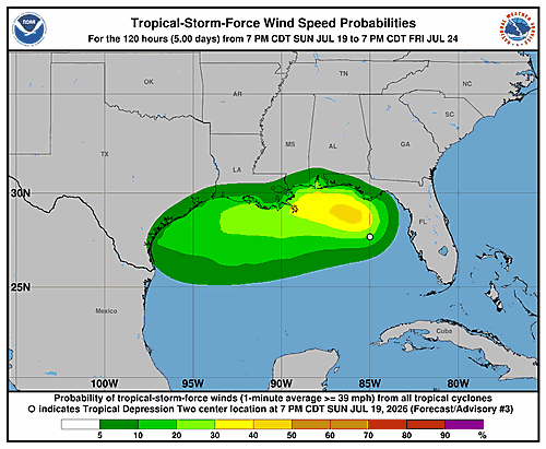
The National Hurricane Center has issued updated wind speed probability graphics for Tropical Depression Two, designated as the second Atlantic tropical system of the 2026 season.
The imagery, which tracks the likelihood of 34-knot or higher wind speeds, was last updated on Sunday, July 19, 2026, at approximately 9:22 p.m. GMT.
The graphics cover a 120-hour forecast window and are intended to help residents and emergency managers assess potential storm impacts. Forecasters urge those in potentially affected areas to continue monitoring official National Hurricane Center advisories for the latest information as the system develops.
The National Hurricane Center has released updated wind speed probability graphics for Tropical Depression Two, tracking the storm system’s potential impact over the next five days.
The graphics illustrate the probability of 34-knot wind speeds affecting different areas within a 120-hour forecast window. These probability maps help forecasters and the public understand where tropical storm-force winds are most likely to occur as the system develops.
The wind speed probability information was last updated on Sunday, July 19, 2026, at approximately 9:22 p.m. GMT, according to the National Hurricane Center.
Residents in areas that could be affected by the storm system are encouraged to monitor the latest updates from the National Hurricane Center as forecasts may change as the depression evolves.
Drivers heading eastbound on Delaware Route 2 should be aware of a right lane closure currently in effect between Possum Park Road and Finger Road.
The closure is expected to remain in place until 6 a.m. Motorists traveling through the area are encouraged to use caution and allow extra travel time.
Forecasters are keeping a close eye on Tropical Depression Two as it churns through the Gulf of Mexico, with the possibility of tropical storm conditions developing along the Florida Panhandle by late Monday.
According to the National Hurricane Center, as of 7:00 PM CDT on Sunday, July 19, the center of the storm was positioned near coordinates 27.7 degrees north latitude and 85.0 degrees west longitude. The system’s movement speed was not specified in the latest advisory.
The depression currently has a minimum central pressure of 1008 millibars, with maximum sustained winds clocking in at approximately 30 miles per hour. Forecasters warn that tropical storm conditions remain possible in the Florida Panhandle region by late Monday as the system continues to develop.
Residents along the Gulf Coast, particularly in the Florida Panhandle, are urged to stay informed and monitor the latest updates from the National Hurricane Center as the storm evolves.
The National Hurricane Center has released updated wind speed probability graphics for Tropical Depression Two, tracking the system’s potential impact across affected regions.
The graphics display the probability of 34-knot wind speeds occurring within a 120-hour forecast window. These probability maps help forecasters and residents assess the likelihood of tropical storm-force winds reaching specific areas.
The wind speed probability graphic was last updated Sunday, July 19, 2026, at 21:22 GMT. Residents in potentially affected areas are encouraged to monitor the latest updates from the National Hurricane Center as the system develops.
The National Hurricane Center has issued updated wind speed probability graphics for Tropical Depression Two, with the latest forecast imagery reflecting conditions as of Sunday, July 19, 2026.
The graphic displays the probability of 34-knot wind speeds associated with the storm over a 120-hour forecast period. These visuals are used to help forecasters and the public understand the likelihood of tropical-storm-force winds reaching various areas as the system develops.
Residents and boaters in potentially affected regions are encouraged to continue monitoring the National Hurricane Center for the most current information as the storm system evolves.
The National Hurricane Center issued its second forecast discussion for Tropical Depression Two on Sunday afternoon, noting that the storm has shown little change over the past several hours but continues to pose a growing threat to the Gulf Coast.
As of 4:00 PM CDT Sunday, July 19, 2026, the depression’s circulation remains well organized, with deep thunderstorm activity gradually building near the storm’s center and in outer bands. Satellite data from an ASCAT pass around 15Z and measurements from Air Force Reserve reconnaissance aircraft both confirmed peak winds of approximately 25 knots, so the initial intensity has been kept at 25 knots for this advisory. The storm is described as large and somewhat spread out, with associated shower activity blanketing much of the eastern Gulf of Mexico.
The depression has barely moved throughout the day and has actually drifted slightly to the southeast over the past few hours. Forecasters say this near-standstill motion is caused by very weak steering currents — the system is essentially trapped between a ridge of high pressure over the western Atlantic, another ridge over the south-central and southwestern United States, and a trough over the northeastern U.S.
Most computer forecast models show the storm drifting northwestward over the next couple of days. Its outer bands could begin bringing tropical storm conditions to parts of the Florida Panhandle as early as late Monday. By Tuesday, a turn toward the west or west-northwest is expected as a ridge over the U.S. builds eastward and takes over as the main steering feature. That movement would carry the system along or just off the northern Gulf Coast through the middle and latter part of the week. The NHC has shifted its track forecast slightly to the south, in line with its top-performing forecast models.
Strengthening is expected to be gradual, particularly in the short term, due to the storm’s sprawling size, nearby dry air, and northeasterly wind shear. Despite those obstacles, the system is forecast to reach tropical storm strength on Monday while positioned offshore of the Florida Panhandle. If wind shear relaxes mid-week and the storm remains over open water, additional strengthening is possible. Model forecasts vary widely — ranging from the system staying a tropical depression all the way to potentially becoming a hurricane. The NHC’s official intensity forecast falls between those extremes but leans toward the stronger end of the guidance. Forecasters caution, however, that confidence in the intensity forecast is low given uncertainty about how much the storm will interact with land.
The National Hurricane Center highlighted three key messages for the public:
First, the depression is expected to gradually strengthen and could bring tropical storm conditions to parts of the Florida Panhandle beginning late Monday, where a Tropical Storm Watch is already in effect.
Second, residents and interests in Alabama, Mississippi, Louisiana, and Texas should closely monitor this storm’s progress, as tropical storm watches may be issued for portions of those areas within the next day or two.
Third, flash flooding will be possible through Thursday along the eastern and central Gulf Coast, stretching from western Florida through southern portions of Alabama, Mississippi, and Louisiana.
This forecast was prepared by Forecaster Cangialosi at the National Hurricane Center.
The National Hurricane Center has released updated wind speed probability graphics for Tropical Depression Two, an Atlantic storm system currently being monitored by forecasters.
The graphic shows the probability of 34-knot or greater wind speeds occurring within a 120-hour forecast period. This type of information helps officials and residents assess the likelihood of tropical-force winds reaching various areas as the storm develops.
The wind speed probability data was last updated on Sunday, July 19, 2026, at approximately 8:49 p.m. GMT. Forecasters will continue to issue updates as the storm system evolves.
Residents in coastal and low-lying areas are encouraged to monitor the latest advisories from the National Hurricane Center as conditions may change.
A tropical depression is slowly meandering in the Gulf of Mexico off the western coast of Florida, and forecasters say it could strengthen enough to bring tropical storm conditions to the Florida Panhandle by late Monday.
According to the National Hurricane Center, as of 4:00 PM CDT on Sunday, July 19, the center of the storm — known as Tropical Depression Two — was positioned near latitude 27.5 North, longitude 85.0 West. The storm’s movement was minimal at the time of the report.
The system had a minimum central pressure of 1010 millibars, with maximum sustained winds of approximately 30 mph. That places it just below tropical storm strength, which begins at 39 mph.
Residents and travelers along the Florida Panhandle are urged to monitor the latest updates from the National Hurricane Center as the storm’s track and intensity continue to be assessed.
The National Hurricane Center in Miami issued Forecast Advisory Number 2 for Tropical Depression Two at 9:00 p.m. UTC on Sunday, July 19, 2026, tracking a developing tropical system in the Gulf of Mexico.
As of the advisory, the center of the depression was located near latitude 27.5 degrees North and longitude 85.0 degrees West. Forecasters say the position is accurate within about 30 nautical miles. The storm was essentially stationary at the time of the report, with no forward movement detected.
Maximum sustained winds were measured at 25 knots, with gusts reaching up to 35 knots. The storm’s minimum central pressure was estimated at 1010 millibars.
Looking ahead, the National Hurricane Center’s forecast calls for gradual strengthening over the next several days. By Monday evening, winds are expected to increase to around 35 knots. The storm is projected to continue drifting northward and westward, with winds potentially climbing to 45 knots by early Wednesday morning and reaching 50 knots — near tropical storm force — by Wednesday evening near longitude 88.8 degrees West.
The extended outlook through Thursday and Friday shows the system maintaining around 50-knot winds before weakening slightly as it moves inland, with the storm projected to reach the Louisiana coast area by Friday.
Forecasters caution that track errors on extended outlooks average around 125 nautical miles on Day 4 and 175 nautical miles on Day 5, with intensity errors averaging about 15 knots per day in the extended range.
Ships within 300 nautical miles of the storm’s center have been asked to submit reports every three hours. The next full advisory was scheduled for 3:00 a.m. UTC Monday, with an intermediate public advisory expected at midnight UTC. The forecast was issued by forecaster Cangialosi.
A tropical depression churning in the Gulf of Mexico has shown little change in the past several hours, but forecasters say it could intensify into a tropical storm as early as Monday.
As of 4:00 PM CDT Sunday, July 19, 2026, the National Hurricane Center reported that the storm’s circulation remains well organized, with deep convection gradually building near its center and in outer bands. Reconnaissance aircraft from the Air Force Reserve and satellite wind data both confirmed peak winds of around 25 knots, keeping the storm’s initial intensity at that level for this advisory. The depression is described as large and somewhat spread out, with shower activity covering much of the eastern Gulf of Mexico.
The system has barely moved throughout the day and has actually drifted slightly southeastward over the past several hours. Forecasters attribute the near-standstill to very weak steering currents — the depression is caught between a ridge over the western Atlantic, another ridge over the south-central and southwestern United States, and a trough over the northeastern U.S.
Most forecast models show the cyclone drifting northwestward over the next couple of days. Outer bands could bring tropical storm conditions to parts of the Florida Panhandle beginning late Monday, where a Tropical Storm Watch is already in effect. By Tuesday, a turn to the west or west-northwest is expected as a ridge over the U.S. builds eastward and takes over as the primary steering feature. That track would carry the system along or just offshore of the northern Gulf Coast through the middle and latter part of the week.
The National Hurricane Center has nudged its track forecast slightly southward, in line with the top-performing forecast models.
Strengthening is expected to be slow, particularly in the short term, due to the storm’s sprawling structure, dry air nearby, and northeasterly vertical wind shear. However, the shear could briefly ease mid-week, potentially allowing for additional strengthening if the system remains over open water. Forecast models range widely — from the system staying a tropical depression to possibly reaching hurricane strength. The official intensity forecast falls between those extremes but leans toward the higher end, though forecasters caution that confidence is low given uncertainty about how much the storm will interact with land.
Key Messages from the National Hurricane Center:
1. The depression is expected to gradually strengthen and could bring tropical storm conditions to parts of the Florida Panhandle beginning late Monday, where a Tropical Storm Watch is in effect.
2. Residents in Alabama, Mississippi, Louisiana, and Texas should monitor this system closely, as watches could be issued for portions of those areas within the next day or two.
3. Flash flooding will be possible through Thursday along the eastern and central Gulf Coast, from western Florida through southern Alabama, Mississippi, and Louisiana.
This forecast was issued by Forecaster Cangialosi at the National Hurricane Center.
The National Hurricane Center in Miami released its second wind speed probability advisory for Tropical Depression Two on Sunday, July 19, 2026, at 9 p.m. Coordinated Universal Time.
According to the advisory, the center of the tropical depression was positioned near latitude 27.5 degrees North and longitude 85.0 degrees West at that time. The storm’s maximum sustained winds were clocking in at approximately 25 knots — that’s around 30 miles per hour or 45 kilometers per hour.
The Hurricane Center provided detailed probability tables showing the likelihood of sustained winds reaching tropical-storm force (34 knots / 39 mph), 50-knot (58 mph), and hurricane-force (64 knots / 74 mph) thresholds at dozens of specific locations along the Gulf Coast over the next five days.
Among the locations with notable cumulative probabilities for tropical-storm-force winds over the five-day period: Apalachicola showed a 19 percent cumulative chance, Panama City, Florida reached 22 percent, and a Gulf forecast area point near 29 degrees North and 87 degrees West showed a 47 percent cumulative probability — the highest in the table. Locations further west, including Buras, Louisiana at 18 percent, New Orleans at 12 percent, and Cameron, Louisiana at 21 percent, also carried measurable chances.
Further west along the Texas Gulf Coast, Galveston showed a 16 percent cumulative chance of tropical-storm-force winds, while Matagorda, Texas registered 13 percent. Corpus Christi and Rockport, Texas each carried a 3 percent cumulative probability.
Some locations also showed small but notable chances of 50-knot winds, including Cameron, Louisiana at 4 percent and Galveston, Texas at 3 percent. A handful of Gulf forecast area grid points showed probabilities for hurricane-force 64-knot winds, though those remained at or below 2 percent cumulatively.
The advisory was prepared by forecaster Cangialosi at the National Hurricane Center.
The National Hurricane Center is tracking Tropical Depression Two in the Atlantic Ocean, releasing updated wind speed probability graphics for the system.
According to the latest data from the National Hurricane Center, the 34-knot wind speed probability forecast was last updated on Sunday, July 19, 2026, at 15:21 GMT.
Residents in coastal areas are encouraged to continue monitoring official National Hurricane Center updates as the storm system develops.
The National Hurricane Center has issued updated wind speed probability information for Tropical Depression Two, the second named tropical system of the Atlantic season.
Graphics released by the agency show the probability of 34-knot wind speeds affecting different regions over a five-day, or 120-hour, forecast window.
The wind speed probability data was last updated on Sunday, July 19, 2026, at 15:21 GMT. Residents in potentially affected coastal areas are encouraged to monitor the latest updates from the National Hurricane Center as the storm develops.
A tropical depression is slowly drifting off the west coast of Florida, prompting forecasters to keep a close eye on the system’s movements.
According to the National Hurricane Center, as of 1:00 PM Central Daylight Time on Sunday, July 19, the center of Tropical Depression Two was positioned near latitude 27.8 north, longitude 85.0 west. The storm was barely moving, tracking north-northwestward at only 1 mile per hour.
The depression had a minimum central pressure of 1011 millibars, with maximum sustained winds of approximately 30 miles per hour. At that wind speed, the system remains classified as a tropical depression, below the 39 mph threshold required for tropical storm status.
Forecasters will continue to monitor the slow-moving system for any signs of strengthening or a change in direction.
The National Hurricane Center has issued updated wind speed probability graphics for Tropical Depression Two, with the latest information reflecting conditions as of Sunday, July 19, 2026 at 15:21 GMT.
The graphic released by forecasters shows the 34-knot wind speed probabilities over a 120-hour period, giving forecasters and the public a look at where tropical storm-force winds may be felt as the system develops.
Residents are encouraged to continue monitoring official National Hurricane Center updates as the storm system evolves.
The National Hurricane Center has released updated wind speed probability graphics for Tropical Depression Two, an Atlantic tropical system currently being monitored by forecasters.
The latest graphic, showing the probability of 34-knot wind speeds over a 120-hour period, was last updated on Sunday, July 19, 2026 at 15:21 GMT.
Residents along the East Coast, including those on the Delmarva Peninsula, are encouraged to keep a close eye on National Hurricane Center updates as the storm system continues to be tracked.
The National Hurricane Center has issued updated wind speed probability graphics for Tropical Depression Two, tracking the storm system’s potential impact across a wide area.
The forecast graphic, which covers a 120-hour outlook period, illustrates the probability of 34-knot wind speeds reaching different locations as the tropical depression continues to develop.
The wind speed probability information was last updated on Sunday, July 19, 2026, at 15:21 GMT, according to data from the National Hurricane Center.
Residents and mariners are encouraged to monitor the latest updates from the National Hurricane Center as the storm system evolves.
The National Hurricane Center has released updated wind speed probability graphics for Tropical Depression Two, an Atlantic storm system currently being monitored by forecasters.
The latest wind speed probability chart, which shows the likelihood of 34-knot winds affecting various areas, was last updated on Sunday, July 19, 2026, at 15:21 UTC.
Residents in potentially affected coastal areas are encouraged to monitor updates from the National Hurricane Center as the storm system continues to be tracked.
The National Hurricane Center is keeping a close watch on Tropical Depression Two, releasing updated wind speed probability graphics for the storm system.
According to the latest data from the National Hurricane Center, the 34-knot wind speed probability map for the storm was last updated on Sunday, July 19, 2026, at 15:21 UTC.
Residents and mariners in areas that could be impacted by the tropical system are encouraged to monitor updates from the National Hurricane Center as forecasters continue to track the depression’s development and movement.
A local weather statement was issued at 11:00 AM EDT for the Tallahassee, Florida area, according to information released by the National Hurricane Center.
The statement was distributed through official weather channels serving the Tallahassee region. No additional details from the statement’s content were available for further reporting.
Residents in and around Tallahassee are encouraged to stay informed by following updates from their local emergency management officials and weather services.
A local weather statement was issued at 10:11 AM CDT for the Mobile, Alabama and Pensacola, Florida region, according to information from the National Hurricane Center.
The statement, originating from the National Hurricane Center’s text advisory system, was directed at residents in the Mobile, Alabama and Pensacola, Florida areas.
Those living in or near the affected region are encouraged to stay informed and follow guidance from local emergency management officials as conditions develop.
A tropical depression has formed in the Gulf of Mexico off the west coast of Florida, according to the National Hurricane Center. In response, forecasters have issued a Tropical Storm Watch for the Florida Panhandle.
As of 10:00 AM CDT on Sunday, July 19, the center of the storm — designated Tropical Depression Two — was positioned near latitude 28.0 North, longitude 85.3 West. The system was drifting to the north-northwest at a slow pace of just 2 miles per hour.
The depression had a minimum central pressure of 1011 millibars, with maximum sustained winds of approximately 30 mph. Residents and visitors along the Florida Panhandle should monitor the latest updates from the National Hurricane Center as the storm continues to develop.
The National Hurricane Center in Miami issued its first official advisory Sunday afternoon on Tropical Depression Two, a newly organized tropical system now churning in the Gulf of Mexico.
As of 3:00 p.m. UTC on Sunday, July 19, 2026, the center of the depression was located near latitude 28.0 degrees north, longitude 85.3 degrees west. Forecasters say the position is accurate within about 30 nautical miles.
The storm is moving very slowly — nearly drifting — toward the north-northwest at just 2 knots. Its minimum central pressure is estimated at 1011 millibars, with maximum sustained winds of 25 knots and gusts reaching up to 35 knots.
Looking ahead, forecasters expect the system to gradually strengthen. By Monday morning, winds are projected to reach 30 knots with gusts to 40 knots. By Monday evening, the storm could approach tropical storm strength with winds near 35 knots. The system is forecast to continue slowly intensifying through Wednesday, potentially reaching 50 knots — just below hurricane strength — by the evening of July 22.
The extended outlook shows the storm tracking westward toward the Gulf Coast, with the center possibly moving inland near the Louisiana coast area by July 24, 2026, while still carrying winds of around 45 knots.
The National Hurricane Center notes that track forecasts carry an average error of about 125 nautical miles on day four and 175 nautical miles on day five, meaning the storm’s exact path remains uncertain. Intensity forecasts also carry an average error of about 15 knots per day.
Ships within 300 nautical miles of the storm’s center have been asked to submit reports every three hours to help forecasters track the system. The next full advisory was scheduled for 9:00 p.m. UTC Sunday, with an intermediate public advisory due at 6:00 p.m. UTC. The advisory was issued by forecaster Cangialosi.
A tropical depression has officially formed in the northeastern Gulf of America, and forecasters at the National Hurricane Center in Miami are watching it closely as it slowly drifts toward the Florida Panhandle.
The system, designated Tropical Depression Two, was classified Sunday morning after developing a well-defined low-level circulation over the past several days. While convective activity — the storm-related thunderstorm clusters — remains uneven due to dry air pushing in from the northeast, there is enough persistent storm activity near the center and in surrounding bands to qualify it as a tropical depression. The circulation is described as large and still relatively weak.
Based on surface weather observations and earlier satellite wind data, the storm’s initial intensity has been set at 25 knots, or about 30 miles per hour, with a minimum central pressure of 1011 millibars. Air Force Hurricane Hunter aircraft are scheduled to fly into the system later Sunday to get a better picture of its structure.
Pinpointing the storm’s exact movement has been tricky since it only recently became well organized, but forecasters believe it is currently drifting north-northwestward at about 3 knots. The system is caught between competing weather features — a ridge over the western Atlantic, another ridge over the south-central and southwestern United States, and a trough over the northeastern U.S. — all of which are creating weak steering currents.
That pattern is expected to carry the depression slowly northwestward through Monday night, bringing it close enough to the Florida Panhandle to produce tropical storm conditions there. A Tropical Storm Watch has already been issued for that area. After that, forecasters expect the storm to turn westward or west-northwest as a ridge over the southern United States expands eastward, potentially pushing the system near or across the Gulf Coast during the middle and latter part of the week.
Strengthening is expected to be slow at first, given the storm’s sprawling structure, nearby dry air, and some northeasterly wind shear working against it. However, forecasters expect it to reach tropical storm status as it approaches the Florida Panhandle over the next day or two. There may be a better window for additional strengthening once the system turns westward, though how much it intensifies will depend heavily on how much time it spends over land versus open water.
The National Hurricane Center’s track forecast leans toward the upper end of available computer model guidance, though forecasters acknowledge there is low confidence in the forecast given uncertainty about how much land interaction the storm will experience.
Key Messages from the National Hurricane Center:
1. The depression is forecast to gradually strengthen and could bring tropical storm conditions to parts of the Florida Panhandle, where a Tropical Storm Watch is in effect.
2. Residents in Alabama, Mississippi, Louisiana, and Texas should monitor the storm’s progress, as watches may be needed for portions of those areas within the next day or two.
3. Flash flooding will be possible through Thursday along the eastern and central Gulf Coast, stretching from western Florida through southern Alabama, Mississippi, and Louisiana.
The forecast was issued by Forecaster Cangialosi at the National Hurricane Center.
The National Hurricane Center in Miami issued its first wind speed probability bulletin for Tropical Depression Two on Sunday, July 19, 2026, at 3:00 p.m. Coordinated Universal Time.
At the time of the report, the center of the tropical depression was positioned near latitude 28.0 degrees North and longitude 85.3 degrees West, with maximum sustained winds of approximately 25 knots — about 30 miles per hour or 45 kilometers per hour.
The bulletin outlines the probability of locations along the Gulf Coast experiencing sustained wind speeds reaching at least 39 mph (tropical storm force), 58 mph, or 74 mph over the following five days.
According to the probability table, Apalachicola, Florida faces a 26 percent cumulative chance of experiencing tropical storm-force winds of at least 39 mph by the end of the five-day forecast period. Panama City, Florida carries a 31 percent cumulative probability for the same wind threshold.
Pensacola, Florida shows a 12 percent cumulative probability of reaching tropical storm-force winds, while Mobile, Alabama stands at 11 percent. Areas along the Louisiana coast, including New Orleans and Houma, each carry a 13 percent cumulative chance of tropical storm-force conditions.
Further west, Galveston, Texas has a 15 percent cumulative probability of sustained winds reaching at least 39 mph, with a 3 percent chance of winds hitting 58 mph or higher.
The report was prepared by forecaster Cangialosi at the National Hurricane Center. Residents across the Gulf Coast are encouraged to monitor future updates as the storm system continues to develop.
The National Hurricane Center has issued updated wind speed probability graphics for Tropical Depression Two, tracking the system’s potential impact over the next five days.
The graphic displays the probability of 34-knot wind speeds associated with the tropical depression, covering a 120-hour forecast period. These probabilities help forecasters and the public understand where the storm’s winds are most likely to be felt.
The wind speed probability information was last updated on Sunday, July 19, 2026, at 14:55 GMT, according to the National Hurricane Center.
Residents along the East Coast, including those on the Delmarva Peninsula, are encouraged to monitor updates from the National Hurricane Center as the system continues to develop.
A low-pressure system churning over the Gulf of Mexico near Florida is growing more organized and has an 80% chance of developing into a cyclone within the next 48 hours, the U.S. National Hurricane Center announced in a Sunday advisory.
The Miami-based forecasting agency says the system is expected to continue developing gradually, with a tropical depression likely to form either later Sunday or by Monday. The storm is projected to drift slowly toward the north or northwest as it strengthens.
China’s national weather authority issued a heavy rain alert Sunday for portions of southern China, coming just one day after officials warned of mountain flood dangers in areas including Chongqing and Yunnan, with potential emergency evacuations ordered in the most at-risk locations.
The massive rain belt cuts diagonally across southern China, extending from the southwestern province of Yunnan all the way to the Yangtze River Delta along the country’s eastern coastline.
Train travel has also been affected — rail officials suspended certain passenger trains operating on the Shanghai–Kunming railway Sunday because of the heavy rainfall, according to state broadcaster CCTV.
In Yunnan, a number of popular tourist destinations, including the Tiger Leaping Gorge, were shut down temporarily after heavy rain pounded the area over the weekend.
The southwestern Guangxi region, which is still dealing with the aftermath of Typhoon Maysak earlier this month, is now facing another round of heavy rain expected to last through Tuesday.
Water levels in some rivers in Guangxi’s Baise area climbed between one and three metres — roughly three to nine feet — over the course of just 24 hours, CCTV reported Sunday.
Meanwhile, rescue crews are working urgently in Chongqing, where a rain-induced landslide struck a county in the southwest on Friday. Eight people have been confirmed dead, and searchers are still trying to locate 34 individuals who remain missing.
Lawson Road is closed between Hollyville Road and Zoar Road following a report of downed wires in the area.
Motorists traveling through that stretch of road are advised to find an alternate route until crews can address the situation and the roadway is cleared for travel.
No further details regarding the cause of the downed wires or an estimated time for the road to reopen have been made available at this time. Drivers should use caution in the surrounding area.
Motorists should avoid the intersection of Mount Zion Road and Seaford Road, which is currently closed due to downed wires in the area.
The closure is in effect while crews work to address the hazardous conditions caused by the fallen wires. Drivers are urged to plan ahead and use alternate routes to avoid delays.
No information regarding the cause of the downed wires or an estimated time for the road to reopen has been released at this time. TV Delmarva will provide updates as more information becomes available.
Tobacco Road is closed at Fox Hole Road following a downed wire incident, according to transportation officials.
Motorists traveling in the affected area are advised to find alternate routes and avoid the intersection until crews are able to clear the hazard and reopen the road.
No information regarding the cause of the downed wires or an estimated time for the road to reopen has been released at this time. Drivers should use caution in the surrounding area and watch for traffic control personnel or detour signage.
The National Weather Service out of Mount Holly, New Jersey issued a Severe Thunderstorm Warning on July 18, beginning at 7:11PM EDT and set to remain in effect until 7:45PM EDT.
Residents in areas covered by the warning are urged to seek shelter immediately, stay away from windows, and avoid any unnecessary travel until the warning has expired.
No additional details regarding storm location, movement, or specific hazards were included in the alert text. Check back for updates as more information becomes available.
The National Weather Service office in Mount Holly, New Jersey issued a Severe Thunderstorm Warning on the evening of July 18, effective from 7:09 PM EDT through 7:30 PM EDT.
Residents in the warned area were advised to seek shelter immediately, move away from windows, and remain indoors until the warning expired. Severe thunderstorms can bring dangerous lightning, damaging winds, and large hail.
If you are under a severe thunderstorm warning, officials recommend staying off roads, unplugging electronics, and avoiding contact with water during the storm. Monitor your local weather for updates as conditions can change rapidly.
The National Weather Service out of Mount Holly, New Jersey issued a Severe Thunderstorm Warning on the evening of July 18, beginning at 6:55 PM EDT and set to remain in effect until 7:30 PM EDT.
Residents under the warning are urged to seek shelter immediately, stay away from windows, and avoid outdoor activities until the warning has been lifted. Severe thunderstorms can bring dangerous lightning, strong winds, and heavy rainfall in a short period of time.
Check the National Weather Service website or your local weather alerts for the most up-to-date information on which areas are included in this warning and any changes to the forecast.
The National Weather Service office in Mount Holly, New Jersey has issued a Severe Thunderstorm Warning that went into effect at 6:54 PM EDT on July 18 and is set to expire at 7:45 PM EDT the same evening.
Residents in the areas covered by this warning are urged to take shelter immediately and remain indoors until the warning has been lifted. Severe thunderstorms can bring dangerous conditions including damaging winds, large hail, and heavy rainfall.
Stay tuned to TV Delmarva for the latest updates as this storm system moves through the area.
The National Weather Service office located in Mount Holly, New Jersey issued a Severe Thunderstorm Warning on July 18, taking effect at 6:42 PM EDT and set to expire at 7:00 PM EDT.
Residents in the areas covered by the warning were advised to seek shelter immediately and remain indoors until the warning expired. Severe thunderstorms can bring dangerous lightning, damaging winds, and heavy rainfall.
The alert was issued through official NWS channels. Anyone in the warned area was encouraged to monitor local weather updates and avoid unnecessary travel until conditions improved.
The National Weather Service out of Mount Holly, New Jersey issued a Severe Thunderstorm Warning on July 18, beginning at 6:40 PM EDT and running through 7:30 PM EDT.
Anyone in the affected area is urged to seek shelter indoors immediately, stay away from windows, and avoid any unnecessary travel until the warning has expired.
Severe thunderstorms can bring dangerous lightning, large hail, and strong damaging winds. Residents should stay tuned to local forecasts for updates as conditions develop.
The National Weather Service out of Mount Holly, New Jersey issued a Tornado Warning on the evening of July 18, effective beginning at 6:38 PM Eastern Time.
The warning was scheduled to expire at 7:00 PM Eastern Time, giving residents a narrow window to seek safe shelter immediately.
When a Tornado Warning is issued, it means a tornado has been detected on radar or spotted by a trained weather observer. Residents in the warned area should move to the lowest level of a sturdy building, away from windows, and protect their heads and necks until the warning has passed.
The National Weather Service out of Mount Holly, New Jersey issued a Tornado Warning on the evening of July 18, effective from 6:27 PM Eastern Time until 7:00 PM Eastern Time.
Residents in the warned area were advised to take shelter immediately and stay away from windows. A Tornado Warning means that a tornado has either been spotted or indicated by weather radar, making it a serious and immediate threat to life and property.
Authorities encouraged anyone in the path of the storm to move to the lowest level of a sturdy building, away from exterior walls, and to avoid seeking shelter under highway overpasses or in vehicles.
Stay with TV Delmarva for any additional updates as this weather situation develops.
The National Weather Service office in Mount Holly, New Jersey has issued a Severe Thunderstorm Warning that went into effect at 6:16 PM EDT on July 18 and is set to expire at 7:00 PM EDT the same evening.
Residents in the warned area are urged to take immediate precautions. Severe thunderstorms can bring dangerous lightning, damaging winds, and heavy rain in a very short period of time.
Stay away from windows, avoid using electrical appliances, and do not venture outside until the warning has been lifted. If you are driving, pull over to a safe location away from trees and power lines.
TV Delmarva will continue to monitor this storm and bring you the latest information as it becomes available.
The National Weather Service office in Mount Holly, New Jersey issued a Severe Thunderstorm Warning on the evening of July 18, effective from 5:59 PM EDT through 6:15 PM EDT.
Residents in the areas covered by the warning were advised to seek shelter immediately and stay away from windows. Severe thunderstorms can bring dangerous lightning, damaging winds, and heavy rainfall in a short period of time.
The warning was issued as part of the NWS’s ongoing effort to alert the public to rapidly developing dangerous weather conditions. Residents are encouraged to monitor local forecasts and heed all warnings issued by the National Weather Service.
The National Weather Service out of Mount Holly, New Jersey issued a Severe Thunderstorm Warning on the evening of July 18, beginning at 5:58 PM EDT and set to expire at 6:15 PM EDT.
Residents in the areas covered by the warning were advised to seek shelter immediately and remain indoors until the warning expired. Severe thunderstorms can bring dangerous lightning, damaging winds, and heavy rainfall in a short period of time.
As always, officials recommend that people stay away from windows, avoid using electrical appliances, and refrain from going outdoors during an active severe thunderstorm warning. If you are driving, pull over safely and wait for conditions to improve.
Stay with TV Delmarva for the latest weather updates as conditions develop in your area.
The National Weather Service office located in Mount Holly, New Jersey issued a Severe Thunderstorm Warning on July 18, beginning at 5:43 PM EDT and remaining in effect until 6:15 PM EDT.
Those in the warned area are urged to seek shelter immediately and remain indoors away from windows until the warning has expired. Severe thunderstorms can bring dangerous lightning, damaging winds, and heavy rainfall in a short period of time.
No additional specifics regarding storm location or expected impacts were included in the alert. Residents should monitor local forecasts and official weather channels for any updates or extensions to this warning.
The National Weather Service out of Mount Holly, New Jersey issued a Severe Thunderstorm Warning on July 18, taking effect at 5:39 PM EDT and remaining in place until 6:15 PM EDT.
Residents in the warned area should seek shelter indoors, stay away from windows, and avoid travel until the warning has expired. Severe thunderstorms can bring dangerous lightning, strong winds, and heavy rainfall in a short period of time.
No additional details about storm location or specific impacts were included in the official alert. Viewers are encouraged to monitor local forecasts and follow guidance from the National Weather Service as conditions develop.
The National Weather Service office located in Mount Holly, New Jersey issued a Severe Thunderstorm Warning on July 18, taking effect at 5:26 PM EDT and remaining in place until 6:15 PM EDT.
Residents in the areas covered by this warning are urged to seek shelter indoors immediately, stay away from windows, and avoid any unnecessary travel until the warning has expired.
Severe thunderstorms can bring dangerous lightning, damaging winds, and large hail. Authorities recommend staying informed through local weather alerts and waiting for an official all-clear before resuming outdoor activities.
The National Weather Service office in Mount Holly, New Jersey issued a Severe Thunderstorm Warning on July 18, effective from 5:14 PM EDT through 6:15 PM EDT.
Residents in the warned area are urged to take cover immediately. Severe thunderstorms can bring dangerous lightning, damaging winds, and large hail that pose serious risks to people caught outdoors.
Authorities recommend moving indoors, staying away from windows, and avoiding travel until the warning has expired. Do not wait until conditions worsen before taking action.
Check the National Weather Service for the latest updates and watch for any additional warnings or advisories that may be issued as storms develop.
The National Weather Service office in Mount Holly, New Jersey has issued a Tornado Watch for the region, beginning at 1:55 PM EDT and running through 9:00 PM EDT this evening, July 18.
A Tornado Watch means that weather conditions are favorable for the development of tornadoes. Residents are urged to stay weather-aware and keep a close eye on updated forecasts throughout the remainder of the afternoon and evening.
If a Tornado Warning is issued for your area, you should immediately move to the lowest floor of a sturdy building, away from windows, and take cover. Do not wait to see or hear a tornado before taking action.
TV Delmarva will continue to monitor this weather situation and provide updates as conditions develop. Stay tuned for the latest information from your local forecast team.
Southbound travelers on Coastal Highway, also known as Delaware Route 1, should expect slow going between Dartmouth Drive and Rehoboth Avenue Extension.
According to Delaware Department of Transportation, heavy congestion in that stretch is adding 15 to 20 minutes to travel times for drivers heading in that direction.
Motorists are encouraged to allow extra time or consider alternate routes to avoid the backup.
The National Weather Service office in Mount Holly, New Jersey has issued a Heat Advisory that took effect at 12:43 PM EDT on Friday, July 18, and is set to expire at 8:00 PM EDT that same evening.
Residents are encouraged to take steps to stay safe during the advisory period. Health officials generally recommend staying hydrated, limiting time outdoors during peak heat hours, and checking on elderly neighbors and young children during periods of elevated heat.
The advisory was issued to alert the public to potentially dangerous heat conditions expected through the early evening hours.
Canadian military forces were gearing up Saturday to airlift residents out of a remote northwestern Ontario community as massive forest fires continued to push dangerous smoke across a wide stretch of the United States — including right here in Delaware.
Federal Emergencies Minister Eleanor Olszewski announced late Friday that armed forces aircraft would be used to evacuate the roughly 600 people living in Fort Hope, located in a sparsely populated region of northwestern Ontario where some of the most severe fires are raging. The area has limited road access and depends largely on air transportation. Thousands of others from fire-affected zones have already been moved to communities farther south in Ontario.
Canada’s federal natural resources ministry reported Saturday that 69 new fires broke out overnight, pushing the total number of active fires to 955 across the country. The total land burned so far has reached nearly 11,000 square miles — or about 28,500 square kilometers — which remains well below the five-year average. However, wind patterns have driven the smoke across the U.S. border, leading officials to issue air quality alerts and health advisories across multiple states.
As of 8 a.m. Eastern Time Saturday, the U.S. Environmental Protection Agency’s AirNow monitoring site listed air quality as “unhealthy” across a broad region that included southern Ontario, eastern Ohio and West Virginia, most of Pennsylvania and New Jersey, much of Virginia, and all of Maryland, Delaware, and Washington, D.C.
Conditions were even worse in parts of western Pennsylvania, including the Pittsburgh area, where air quality was rated “very unhealthy.” AirNow projected that those areas would see gradual improvement as the day went on.
The smoke is also expected to have minimal effect on Sunday’s soccer World Cup final at New York New Jersey Stadium, according to forecaster AccuWeather, which made that assessment on Friday.
President Donald Trump weighed in on Friday, blaming what he described as poor Canadian forest management practices for the smoke situation. He stated he would factor in the “incalculable cost” of addressing the pollution when determining tariffs on Canadian goods.
Following the president’s remarks, Minister Olszewski pushed back, noting that Canada has put C$12 billion — roughly $8.56 billion U.S. — into forest sustainability and fire prevention efforts since 2020 as the nation faces increasingly dry and warm weather conditions.
Climate experts have long pointed to rising temperatures as a driver of drier forest conditions and greater wildfire risk. Large-scale forest fires have now become a near-annual event across Canada, which is home to some of the largest forested landscapes on the planet.
Fresh rainfall soaking Texas this week is bringing back heartbreaking memories for those who survived the catastrophic Hill Country floods that struck one year ago.
Lorena Guillen finds herself reflecting on that harrowing experience as the rain returns. She and her husband risked their lives attempting to rescue a family who had been caught in the floodwaters near their RV park during last year’s massive flooding event in the Hill Country region.
For survivors like Guillen, the sound and sight of heavy rain is a painful reminder of the destruction and loss that unfolded during the deadly 2025 floods — a disaster that left deep emotional scars that have yet to fully heal.
Less than a year after catastrophic flooding claimed more than 100 lives across Texas’ Hill Country, a fresh round of powerful storms unleashed devastating flash floods this week in many of the same communities — putting newly installed warning systems to the test for the first time.
At least two people lost their lives in the latest disaster, and hundreds of others had to be rescued from rising waters. But unlike the deadly floods of July 2025, many residents said they received timely warnings that gave them a chance to reach safety.
New flood sirens wailed in the middle of the night. Cell phones buzzed with emergency alerts that never came during last year’s disaster. For some, that made all the difference.
Still, the flooding exposed ongoing challenges. Some residents were caught completely off guard, underscoring how difficult it remains to build a reliable early warning network across a vast, rural stretch of Texas long known as Flash Flood Alley.
An Associated Press investigation following last summer’s floods — which killed 136 people, including 28 children at a sleepaway camp for girls — found that state and local agencies had missed multiple opportunities over the past decade to put flood warning systems in place along the Guadalupe River.
That reporting helped spark action. In Kerr County, local officials had acknowledged being hesitant to “cry wolf” during last year’s disaster and failed to send wireless emergency alerts. This time around, Kerr County issued four alerts and the city of Kerrville issued one early Thursday as flood conditions developed, according to an AP review of available data. Residents near Quinlan Creek were told to evacuate to higher ground and warned of “extremely dangerous” flash flooding. The National Weather Service also pushed out flood watches, warnings, and emergency messages through broadcast stations, weather radios, and mobile phones. Those who had signed up for Kerr County’s CodeRED notification system received text message warnings as well.
Kerrville resident Suzanne Sutphin Gschwind said the contrast with last year was striking. “Last year, we got no alarms. We had no idea what was going on,” she said. “This year, very different” — with texts and calls arriving from local authorities, a weather channel, and even her doorbell camera. On one night, alerts came in “about every two hours.” She added, “I think we would all like to err on the side of too much.”
Between early Tuesday morning and approximately 9 a.m. Thursday, the National Weather Service sent 38 alerts to residents in certain southwest Texas communities, including 14 tornado warnings and 24 flood warnings describing conditions as occurring or imminent and potentially “life threatening.”
However, those National Weather Service alerts often lack the highly specific local information that county and city emergency agencies can provide — and those local alerts can be more critical for people deciding whether to evacuate.
An AP review of wireless emergency alert data found no alerts listed as sent by agencies in Uvalde County, which was heavily impacted by flooding, though local agencies there may have used other methods to notify residents.
Jaclyn Gonzales was jolted awake at 2 a.m. Wednesday by a friend calling to warn about a possible tornado near her Uvalde-area home. When she got out of bed, the floor was already wet. “It was the shock of the water to my feet that made me really wake up,” she said.
Kat Sprawls, who lives in Batesville, only found out floodwaters were approaching after a friend called her at 3:30 a.m. Friday. It took five or six calls before she woke up — her phone had been set to do-not-disturb mode. “There’s no warning system at all. It’s just like the flood in Kerrville last year — we had no warnings,” Sprawls said. “Over half of Batesville is under water now.”
Jessica Belmarez, secretary of the Zavala County Sheriff’s Department, said the department was posting evacuation information on Facebook and that officers were going door-to-door in flooded areas, including Batesville.
State Sen. Paul Bettencourt, who authored legislation in 2025 to help fund flood sirens, said newly installed sirens in Ingram and in Kerr and Kendall counties were activated this week. He noted that 28 additional counties are eligible for flood warning funding and that most are working on implementation plans for review by the Texas Water Development Board. “Between the outdoor sirens, and the cellphone alerts, the response was very positive in getting people out of the way and to higher ground,” Bettencourt said. “It’s an enormous improvement over a year ago.”
Tara Bushnoe, manager of the Upper Guadalupe River Authority, said three of the six newly installed sirens in Kerr County were activated to alert people to seek higher ground. The remaining three were located in areas that experienced only minor flooding.
In the small town of Comfort, the volunteer fire department recently added two more sirens to the single one that had been in place for years. Assistant Fire Chief Danny Morales said some residents were reluctant to leave even after the sirens sounded. “Some people just don’t want to leave — that’s our problem here,” he said. “But we did set them off twice, probably an hour from one to another, just because we had people just lingering, and not wanting to move.”
Ian Cunningham launched a company called River Sentry following the 2025 floods, building siren towers for privately owned locations such as RV parks, camps, and hotels. The sirens are triggered automatically by rising water levels. The company has now installed 104 sirens along the Guadalupe River, Cunningham said, including several near the site of an RV park where more than three dozen people perished in 2025. “We installed them about three months ago and did not expect them to be used so soon,” he said.
A company called Hononu, which developed water-level sensor technology and a real-time data network, was awarded a state contract making it easier for agencies to purchase its flood warning technology. The fire-tracking app Watch Duty, used by millions of people, also expanded earlier this year to help monitor flood conditions.
Texas Gov. Greg Abbott credited the lessons learned from 2025 with improving this year’s emergency response. “Everybody in Texas has been far more prepared to deal with what has happened this year,” Abbott said at a news conference in Uvalde. “Lives have been saved.”
The National Weather Service office in Mount Holly, New Jersey has put a Flood Watch into effect starting early Friday morning, July 18, and lasting through 2:00 AM EDT on Saturday, July 19.
The watch was issued at 2:13 AM EDT on July 18, signaling that conditions are favorable for flooding to develop across the affected area during that timeframe.
A Flood Watch means that flooding is possible. Residents are encouraged to monitor local forecasts closely, avoid low-lying areas prone to water accumulation, and be ready to act quickly if a Flood Warning is issued. Do not attempt to drive through flooded roadways.
TV Delmarva will continue to monitor this weather alert and provide updates as conditions develop. For the latest information, stay tuned to your local forecast.
At least four people lost their lives and four more remain missing after a fast-moving flash flood devastated a mountain village in Vietnam’s northern Lai Chau province, according to state media reports released Saturday.
The flood struck Muong Than village in the early morning hours of Friday, following several days of relentless heavy rain across multiple areas of northern Vietnam. Seven people were also reported injured in the disaster, according to the Vietnam News Agency.
Images published by the Vietnam News Agency showed thick red mud and floodwaters covering the village, with boulders and wooden logs heaped along a heavily damaged roadway.
Vietnam regularly faces deadly storms and flooding during its rainy season, which is most intense between July and September. Government figures show that natural disasters — the majority of them floods — claimed 489 lives across the country last year.
Since Wednesday, a combination of landslides and flash floods triggered by the ongoing heavy rainfall has caused widespread damage throughout the region. Roads, power infrastructure, and hundreds of homes have been affected, and approximately 238 hectares of crops have been submerged, according to the country’s disaster management agency.
Forecasters are warning that parts of northern Vietnam could receive rainfall totals reaching up to 250 millimeters on Saturday alone, raising the threat of additional flash floods and landslides in the coming hours.
The National Weather Service office in Mount Holly, New Jersey has issued a Flood Watch for the region, effective from the evening of Thursday, July 17 through 2:00 AM EDT on Saturday, July 19.
A Flood Watch means that conditions are favorable for flooding to develop in the watch area. Residents are urged to stay informed and be ready to take action if flooding begins or a Flood Warning is issued.
Authorities recommend that people avoid low-lying areas and be cautious near streams, drainage ditches, and other bodies of water that could rise quickly during heavy rainfall. Do not attempt to drive through flooded roadways.
TV Delmarva will continue to monitor this weather situation and provide updates as conditions develop. For the latest information, keep an eye on official National Weather Service alerts and your local forecast.
The National Weather Service office in Mount Holly, New Jersey has issued a Flood Watch for the area, effective from the evening of Thursday, July 17 at 9:25 PM Eastern Time through the early morning hours of Saturday, July 19 at 2:00 AM Eastern Time.
A Flood Watch means that conditions are favorable for flooding to develop in the warned area. Residents should remain alert, especially in low-lying areas or near bodies of water, and be prepared to take action if flooding begins or a warning is issued.
Authorities encourage people to avoid driving through flooded roadways and to monitor local weather updates closely as conditions evolve over the coming days.