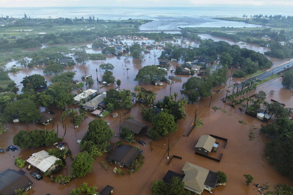
Recovery teams on Tuesday started assessing destruction caused by an unexpected heavy rainfall that unleashed rushing floodwaters through a residential area close to Honolulu’s city center — marking the most recent episode in a string of severe weather and flooding events that have battered Hawaii during the past two weeks.
The assessment comes as communities work to recover from what has been described as a photo gallery documenting the flooding damage, compiled by Associated Press photographers.
HONOLULU (AP) — Assessment teams started examining flood damage Tuesday following an unexpected deluge that turned streets into rushing rivers in a Honolulu-area neighborhood — marking another chapter in two weeks of devastating storms that have battered Hawaii.
Communities along Oahu’s North Shore, renowned for world-class surfing waves, were still recovering from Hawaii’s most destructive flooding in 20 years when Monday’s storm dumped inches of rainfall on the island’s southern region. Muddy brown waters cascaded down Manoa Valley streets just miles from downtown Honolulu, carrying away vehicles and inundating large sections of the community.
“I was shocked to see how much flash flooding there was in my area,” said resident Andrew Phomsouvanh, who captured footage of roadways transformed into rushing waterways. “The water just keeps coming.”
Natalie Aczon had stepped into a pharmacy Monday to collect her mother’s prescription. Within 15 minutes of leaving the store, water was thundering down the road beside the shopping plaza.
“People came running out from Longs and one of the guys actually said, ‘That’s my white car.’ And it had elevated,” she said.
Monday’s intense rainfall caught even National Weather Service forecasters by surprise. While they anticipated that remaining instability from a strong winter weather system known as a “Kona low” might produce additional precipitation, their computer models struggle to predict moisture levels in such systems, explained forecaster Cole Evans.
“When you think it’s over it’s not quite over,” he said Tuesday.
The storm system produced rainfall rates of 2 to 4 inches per hour in a very concentrated area: A measurement station in the valley’s upper reaches recorded 6 inches of rain, while the nearby airport received barely one-hundredth of an inch.
Evans reported the Kona low was shifting eastward and shouldn’t create additional intense rainfall like Monday’s event. Weather officials issued a flash flood warning for eastern Maui.
No fatalities or major injuries were immediately reported, though officials confirmed hundreds of North Shore homes sustained damage from the previous week’s flooding, which occurred when heavy rains saturated ground already soaked from an earlier winter storm.
Rescue teams saved more than 230 individuals. The floodwaters displaced homes from their foundations, swept vehicles from parking areas, and coated walls, floors, and countertops with thick red volcanic sediment.
Emergency evacuation orders affected 5,500 residents north of Honolulu, with some people escaping on surfboards through waist-deep and chest-high waters.
Agricultural operations statewide reported damage exceeding $9.4 million as of Monday, based on assessments by Agriculture Stewardship Hawaii, the Hawaii Farm Bureau, and partner organizations.
Prior to Monday’s storm, Gov. Josh Green estimated total storm costs could exceed $1 billion, encompassing damage to aviation facilities, educational institutions, transportation infrastructure, residential properties, and a Maui medical facility in Kula. He characterized it as the state’s most severe flooding event since 2004, when Manoa floods submerged homes and a University of Hawaii library.
Green’s administration announced Tuesday that a federal major disaster declaration request had been submitted to the Trump administration.
Molly Pierce, representing the Oahu Emergency Management Agency, noted that alongside volunteers and government workers conducting cleanup operations, a private contractor had begun collecting, organizing, and hauling away massive debris accumulations.
She described the weather pattern as “extremely unusual” while expressing cautious hope Tuesday that the rainfall was finally subsiding.
“Most of us have not seen something that just keeps going like this,” Pierce said. “We feel like we keep getting punched down. But we’ll keep getting back up.”
Climate scientists indicate that intense and frequent heavy rainfall events in Hawaii have become more common due to human-driven climate change.
The National Weather Service’s Tsunami Warning Center performed a scheduled test of their emergency notification system on March 24th, activating a practice alert that remained in effect for exactly one hour.
The test warning began at 12:31 PM Eastern Daylight Time and concluded at 1:31 PM EDT on the same day. These routine exercises help ensure the tsunami alert infrastructure functions properly when real emergencies occur.
Such testing procedures are conducted periodically to verify that warning systems can effectively reach the public and emergency management officials during actual tsunami threats.
The National Hurricane Center is introducing a major update to its widely recognized hurricane forecast “cone” ahead of the 2026 Atlantic hurricane season, aiming to improve how storm risks are communicated to the public.
The updated cone graphic will build on recent experimental versions by better highlighting hazards not just along the coast, but also farther inland. This comes after years of research showing many people mistakenly believe areas outside the cone are safe from impacts, when in reality, dangerous conditions can extend hundreds of miles from a storm’s center.
What’s Changing
The new 2026 cone graphic is expected to more clearly integrate watches and warnings into the display, including inland tropical storm and hurricane alerts. This enhancement is designed to give a more complete picture of where impacts like damaging winds could occur, not just where the storm center is forecast to track.
In recent years, the cone has already evolved from a simple track forecast into a more comprehensive communication tool. The updated version continues that trend, emphasizing that the cone represents the probable path of the storm’s center, not the full extent of impacts.
Why It Matters
The change comes as hurricanes are becoming more complex and, at times, more rapidly intensifying. NOAA says improving how forecast information is displayed is critical to ensuring the public properly understands risk and takes appropriate action.
Past storms have shown that impacts such as storm surge, inland flooding, and tornadoes can occur well outside the cone, leading to dangerous misconceptions if people focus only on the center track.
A Continued Push for Better Forecast Communication
The cone update is part of a broader effort by NOAA to modernize hurricane forecasting. This includes new tools like improved modeling, expanded use of artificial intelligence, and efforts to extend forecast lead times.
Officials stress that while forecast accuracy continues to improve, communication remains just as important as the science itself.
Looking Ahead to 2026
The Atlantic hurricane season officially runs from June 1 through November 30, with regular outlooks beginning in mid-May.
With the updated cone graphic rolling out this season, forecasters hope the changes will lead to better public understanding and ultimately, better decision-making when storms threaten.
Federal weather forecasters are preparing to launch significantly upgraded hurricane tracking maps for the 2026 storm season, designed to help communities better prepare for dangerous weather conditions.
NOAA’s National Hurricane Center announced Monday it will debut enhanced forecast cone graphics and introduce storm surge warning systems for Hawaii as part of comprehensive improvements to their tropical weather products.
“These improvements empower communities to prepare earlier and more effectively for dangerous hazards from tropical storms and hurricanes,” said Michael Brennan, director of NOAA’s National Hurricane Center.
Enhanced Hurricane Tracking Maps
The redesigned tropical cyclone graphics will help residents stay alert to wind dangers from hurricanes and tropical storms, particularly those living away from coastal areas. Starting in 2026, the forecast tracking cone will display tropical storm and hurricane watches and warnings for inland regions.
This enhancement comes after a successful trial period last year that showed the improved forecast cone helped inland communities better recognize and prepare for tropical cyclone wind threats.
Key features of the updated cone graphics include:
• Coverage of all land-based tropical storm and hurricane watches and warnings across the continental United States, Hawaii, Puerto Rico, and U.S. Virgin Islands
• Simplified single shading for the complete 5-day forecast cone
• New legend symbols showing areas under both hurricane watch and tropical storm warning conditions
• Full availability on hurricanes.gov for all tropical cyclone advisories
Weather officials are also testing an experimental version of their tracking cone that will use elliptical shapes instead of circles at each forecast point. This new approach will capture a broader range of possibilities for both storm speed and direction, expanding coverage from the current 67% to 90% of potential forecast scenarios.
The experimental cone graphics will be accessible on hurricanes.gov during the testing phase, though technical issues may occasionally affect timing or availability.
Hawaii Gets Storm Surge Warnings
The Hawaiian Islands will receive new storm surge watches, warnings, and peak surge graphics for the first time. These products expand the Hurricane Center’s storm surge services beyond their current coverage of the U.S. East Coast, Gulf Coast, Puerto Rico, and U.S. Virgin Islands.
The new Hawaiian storm surge products will:
• Provide probability-based forecasts of water and storm surge levels up to 72 hours before hurricane impacts
• Factor in storm track, wind intensity, and wind radius data
• Cover all main Hawaiian Islands
These product enhancements represent the Hurricane Center’s ongoing commitment to improving public safety communications and helping people better understand tropical storm hazards.
Media contact: Maria Torres, NOAA National Hurricane Center, [email protected]
The National Oceanic and Atmospheric Administration (NOAA) is taking a major step toward modernizing how weather data is processed, stored, and delivered, with a new focus on expanding the use of cloud computing across its National Weather Service.
This initiative is aimed at improving the speed, flexibility, and accessibility of critical weather data and forecast tools used by meteorologists, emergency managers, and the public.
Moving Toward a Cloud-Based Future
NOAA officials say transitioning more operations to cloud infrastructure will allow the agency to better handle the growing development of environmental data, particularly as next-generation satellites, radar systems, and numerical weather prediction models continue to produce increasingly large datasets.
By leveraging cloud technology, NOAA can reduce reliance on traditional on-premise systems while enabling faster data processing and more efficient dissemination of forecasts and warnings.
Benefits for Forecasting and Public Safety
The shift is expected to enhance forecast accuracy and timeliness by allowing meteorologists to access and analyze data more quickly. Cloud-based systems also provide greater scalability, meaning NOAA can expand computing resources during high-impact weather events when demand is highest.
For the public, this could translate into improved access to real-time weather information, more reliable services, and faster updates during critical situations such as severe storms, hurricanes, and winter weather events.
Supporting Innovation and Collaboration
Another key advantage of cloud integration is the ability to foster collaboration between NOAA and private-sector partners, researchers, and developers. By making data more accessible through cloud platforms, the agency can support innovation in weather modeling, artificial intelligence, and decision-support tools.
This aligns with NOAA’s broader strategy to modernize the nation’s weather enterprise and strengthen partnerships across government, academia, and industry.
What’s Next
While NOAA is still in the early stages of expanding its cloud capabilities, the agency is actively evaluating how best to integrate these technologies into its operations without disrupting critical services.
The long-term goal is to build a more resilient, flexible, and advanced forecasting system that can meet the increasing demands of a changing climate and more extreme weather patterns.
High pressure will dominate the weather pattern across the Delmarva Peninsula through the middle of the week, bringing a stretch of dry, calm, and seasonable conditions.
Expect plenty of sunshine today with a seasonably chilly feel, as high pressure settles directly over the region. Temperatures will gradually moderate into Wednesday as this system shifts offshore, allowing for increasing clouds and a slight warm-up.
By Thursday, a noticeable warming trend takes hold across Delmarva as southerly flow strengthens ahead of an approaching low pressure system. Afternoon temperatures are expected to climb above normal, marking the mildest day of the week.
That system will bring the next chance of precipitation to the region. Rain is expected to develop Thursday night and continue into Friday morning as a cold front sweeps through the Mid-Atlantic. While this is not a significant rainfall event, most areas across Delmarva can expect around a quarter to a half inch of rain.
Behind the front, conditions turn sharply cooler heading into the weekend. Cold air advection will drop temperatures back below normal, with highs struggling to reach the 40s on Saturday. Despite the cooler air, dry conditions return as strong Canadian high pressure builds into the region.
A gradual moderation in temperatures is expected by Sunday, bringing conditions closer to seasonal norms while keeping dry weather in place.
Delaware Department of Transportation has shut down a section of Lambson Lane after power lines fell across the roadway.
The closure affects both directions of travel on Lambson Lane between Pigeon Point Road and Harbor View Drive. Officials say electrical wires are currently obstructing the road, making it unsafe for vehicles to pass.
DelDOT has not provided an estimated time for when the roadway will reopen. Motorists are advised to find alternate routes while crews work to clear the downed lines.
HONOLULU — Hawaii is grappling with catastrophic flooding that has caused the most severe water damage the state has experienced in twenty years, with torrential waters demolishing homes from their foundations, carrying vehicles away from properties, and coating surfaces with dense, rust-colored volcanic sediment.
Assessment teams worked through Monday to evaluate the devastation, with officials confirming that hundreds of residences have sustained damage, alongside educational facilities and medical centers.
While no fatalities have been confirmed, rescue operations saved more than 230 individuals from the dangerous conditions.
Governor Josh Green estimated storm-related expenses could exceed $1 billion, encompassing destruction to aviation facilities, educational institutions, transportation infrastructure, residential properties, and a medical facility in Kula, Maui. Green characterized it as Hawaii’s most devastating flood event since 2004, when Manoa experienced severe inundation affecting residences and a University of Hawaii library.
On Oahu’s North Shore, renowned for its massive surfing waves, water levels surged rapidly after Friday midnight as intense precipitation fell on ground already waterlogged from storm activity one week prior. Violent currents displaced buildings and vehicles. Emergency officials issued evacuation directives for 5,500 residents north of Honolulu, though these orders were subsequently rescinded, while rescue teams saved more than 230 people from rising floodwaters.
Several residents escaped on surfboards as water levels reached waist or chest depth.
Authorities attributed much of the destruction to the enormous volume of precipitation that occurred within a compressed timeframe.
According to the National Weather Service, sections of Oahu experienced 8 to 12 inches of rainfall, adding to substantial amounts from a previous storm days earlier. Kaala, the island’s tallest mountain, received almost 16 inches during the latter part of last week, in addition to 26.6 inches between March 10 and 16.
Weather patterns called “Kona lows,” characterized by southern or southwestern winds carrying moisture-heavy air masses, have generated the recent flooding events. Climate scientists indicate that heavy rainfall intensity and frequency in Hawaii have grown due to human-induced climate change.
The most severe weather conditions appeared to conclude by Sunday afternoon.
Damage evaluation continues, but Oahu’s Department of Emergency Management had documented over 400 reports of damaged or destroyed residences by Monday, according to spokesperson Molly Pierce.
In certain areas, residents must navigate through sediment reaching knee-depth or higher to access their properties, Pierce explained.
The mud’s texture and distinctive reddish color, resulting from iron oxidation in volcanic earth, creates exceptional cleanup challenges.
“When it’s dry, the dust stains, and when it’s wet, the mud clings,” Pierce stated Monday. She likened it to dense, saturated snow.
Volunteer groups have arrived from throughout Oahu and neighboring islands to assist with debris and sediment removal, Pierce noted.
During Friday’s flooding, authorities cautioned that the 120-year-old Wahiawa dam, located north of Honolulu, faced “imminent failure risk.” While the dam has maintained long-standing vulnerabilities, concerns diminished as water levels dropped.
The earthen facility was constructed in 1906 to enhance sugar cultivation for Waialua Agricultural Co., which later became part of Dole Food Co. Reconstruction occurred following a 1921 collapse.
State officials have classified Wahiawa dam as having “high hazard potential,” stating that failure “will result in probable loss of human life.”
Since 2009, the state has issued four deficiency notices to Dole regarding the dam, and imposed a $20,000 penalty five years ago for delayed safety improvements, according to official records.
Subsequently, Dole offered to transfer the dam, reservoir, and irrigation system to state ownership in return for an agreement to repair the spillway to meet safety requirements.
“The dam continues to operate as designed with no indications of damage,” Dole stated.
Green recommended Sunday that those seeking to assist affected families contribute to the Hawaii Community Foundation, which has activated its Stronger Hawaii Fund to distribute resources across impacted islands.
The Hawaiian Council nonprofit organization also established the Kako’o Oahu initiative to provide housing and financial aid along with additional support for individuals and families. The council provided matching funds for the initial $100,000 in contributions and continues fundraising efforts.
“So many families have been displaced, homes have been damaged, and communities are facing immediate needs,” stated Hawaiian Council CEO Kuhio Lewis. “The path to recovery begins now — it cannot wait.”
A massive heat dome that destroyed March temperature records across 14 states and nationwide is now shifting eastward, potentially creating one of the most widespread heat waves in U.S. history, according to meteorologists and weather historians.
The extreme temperatures aren’t expected to subside anytime soon, possibly lasting until the middle of next week as April begins, according to meteorologist Gregg Gallina from the National Weather Service’s Weather Prediction Center.
“Basically the entire U.S. is going to be hot,” Gallina stated Monday. “The area of record temperatures is extremely large. That’s the thing that’s really bizarre.”
This weather phenomenon — where high atmospheric pressure acts like a lid, trapping scorching air over vast regions — will result in Flagstaff, Arizona experiencing 11 or 12 consecutive days with temperatures exceeding the city’s previous March records, according to meteorologist Jeff Masters from Yale Climate Connections.
As the dome moves eastward, Gallina predicts temperatures will reach the 90s Fahrenheit by Wednesday across southern and central plains states. Between one-quarter and one-third of the lower 48 states will be challenging March temperature records, Gallina explained.
The geographic scope of this heat event likely surpasses two other significant heat waves — the 2012 event in the Upper Midwest and Northeast, and the 2021 Pacific Northwest heat wave — according to weather historian Chris Burt, who authored “Extreme Weather.” While it may not match the size of the 1936 Dust Bowl heat waves, Burt noted that event consisted of multiple heat waves over two summer months, unlike the current single massive occurrence.
However, both the Dust Bowl and 2021 events produced more dangerous conditions with higher temperatures that caused greater harm because they occurred during June and July, Gallina noted.
One positive aspect of the current heat wave is the lower humidity levels compared to what would occur if these temperatures hit during summer months, Gallina added.
Last Friday, four locations in Arizona and California recorded 112 degrees Fahrenheit, according to the Weather Service. This temperature not only broke the previous continental U.S. March record by 4 degrees, but came within just 1 degree of the hottest April temperature ever recorded in the lower 48 states.
Weather historian and climatologist Maximiliano Herrera, who monitors global temperature records, documented 14 states that have set new March temperature records since this heat dome began: California, Arizona, Nevada, Kansas, New Mexico, Nebraska, Utah, South Dakota, Missouri, Iowa, Colorado, Wyoming, Minnesota and Idaho.
“In Mexico, even May records were trashed with March records broken by as much as 14 (degrees Fahrenheit), far more than July 1936, March 1907 or June 2021,” Herrera wrote in an email.
The National Center for Environmental Information recorded at least 479 weather stations setting new March records between Wednesday and Saturday within its monitoring network. Herrera, analyzing broader data sets, believes the actual number is significantly higher. Additionally, 1,472 daily temperature records were broken during the same period, the center reported.
The cause involves the jet stream — which typically moves weather systems from west to east — becoming stuck as far west as the storms currently flooding Hawaii with torrential rains, Masters and Gallina explained.
Last Friday, international climate scientists from World Weather Attribution concluded that such record heat was “virtually impossible” without climate change caused by burning fossil fuels, making it 800 times more probable. These human activities contributed at least 4.7 degrees to the extreme temperatures, according to report co-author Clair Barnes, a scientist at Imperial College of London.
The heat dome should finally move on by late next week, Masters predicted: “We just have to give it time.”
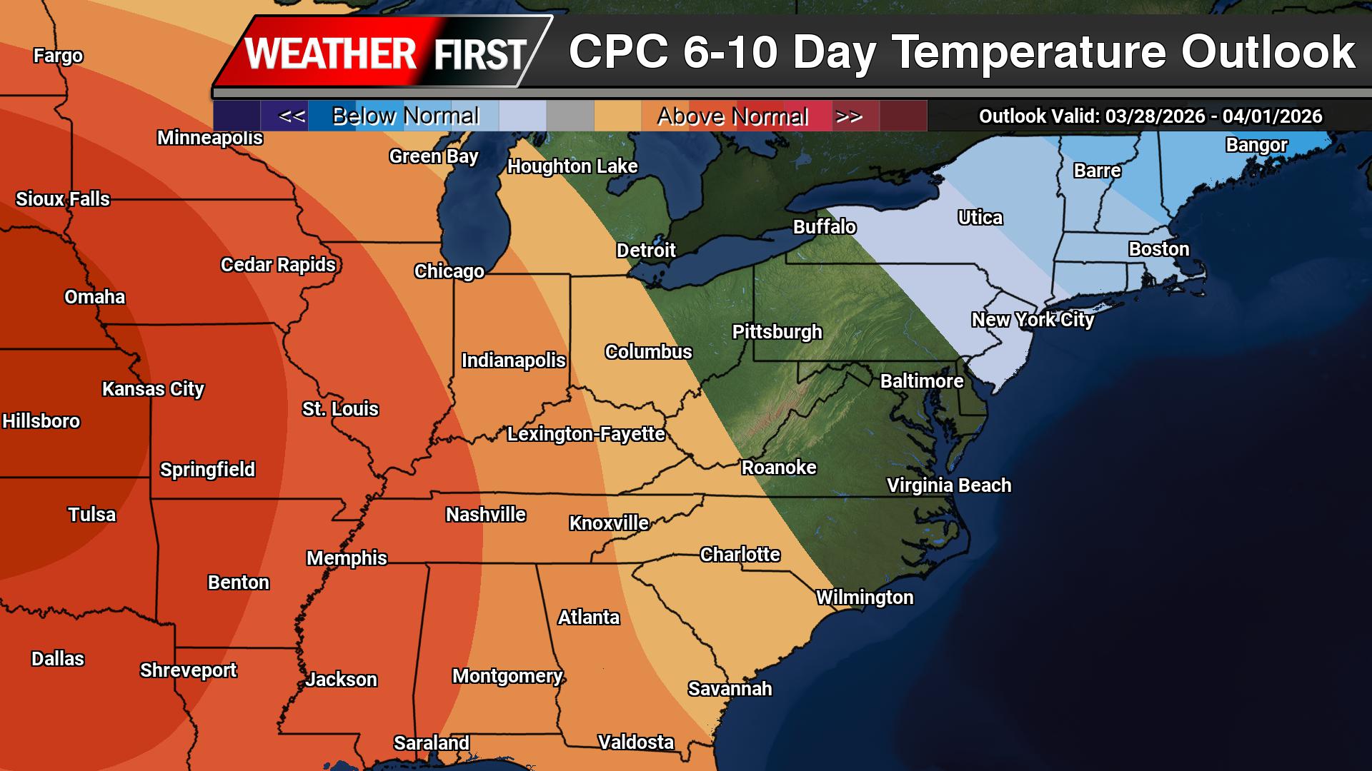
A changing weather pattern is expected across the Mid-Atlantic over the next couple of weeks, starting with a cooler stretch before transitioning to a milder setup heading into early April.
According to the Climate Prediction Center, an upper-level trough developing over the eastern United States will bring below-normal temperatures to the region during the 6 to 10 day period. This pattern supports a push of cooler air into the Mid-Atlantic, with temperatures running several degrees below average as we close out March.
This cooler period will be driven by persistent troughing along the East Coast and a reinforcing northwest flow aloft, allowing cooler air masses to settle into the region.
However, that pattern does not last.
As we move into the 8 to 14 day timeframe, the overall upper-level pattern begins to shift. The eastern trough weakens and lifts out, allowing heights to rise across the eastern United States. This transition opens the door for temperatures to rebound across the Mid-Atlantic, with a growing signal for above-normal temperatures developing.
In other words, after a cool end to March, a warming trend is expected to take hold as we head into early April.
Precipitation, meanwhile, remains somewhat limited through the period. The primary storm track is expected to stay displaced to the north, which favors below-normal precipitation overall across the Mid-Atlantic. While a few systems may pass through, widespread or prolonged rainfall does not appear likely at this time.
The overall takeaway: a cooler-than-normal stretch in the short term will give way to a milder and potentially warmer pattern heading into early April, with generally limited precipitation along the way.
A strong cold front is sweeping across the Delmarva Peninsula this morning, bringing a period of showers followed by a sharp drop in temperatures and increasing winds that will make for a raw and blustery day.
Early this morning, a disorganized but impactful system stretched from eastern Virginia to just off the coast near Cape May, helping to drive a band of steady showers across the region. This rainfall is expected to persist through the early morning hours before gradually tapering off by mid to late morning. However, the unsettled pattern doesn’t end there, as a secondary round of light showers or drizzle may develop around midday into the early afternoon.
Behind the departing system, a strong surge of cold air is quickly moving into the region. Temperatures will likely peak early in the day before steadily falling, dropping into the 40s and low 50s by late morning and afternoon. This cold air advection, combined with thick cloud cover, will create a noticeably colder feel compared to recent days.
In addition to the cooler air, winds will become a major factor. As the pressure gradient tightens between departing low pressure and building high pressure to the west, north to northwest winds will increase to 15 to 20 mph, with gusts reaching 25 to 35 mph throughout the afternoon. These gusty winds will enhance the chilly conditions, making it feel even colder across the peninsula.
Showers should come to an end by mid-afternoon, but skies are expected to remain mostly cloudy for much of the day, reinforcing the cool and damp feel.
Conditions improve tonight as winds gradually diminish and skies begin to clear. Sunshine returns for Tuesday, though temperatures will remain on the cooler side, signaling a quieter but still brisk stretch of weather across Delmarva.
Delaware Department of Transportation officials have implemented a temporary speed reduction on Interstate 495 due to current rainfall affecting the roadway.
The speed limit has been adjusted down to 55 miles per hour as a safety measure while wet conditions persist on the highway. This precautionary step is designed to help motorists maintain better control of their vehicles and reduce the risk of weather-related accidents.
Drivers traveling on I-495 are advised to observe the posted reduced speed limit and exercise additional caution while road surfaces remain slick from precipitation.
HONOLULU — Thousands of Hawaii residents remained without electricity Sunday evening following the most devastating flooding the islands have experienced in more than two decades, as torrential rainfall pounded the region.
The catastrophic downpours struck ground already soaked from a winter storm the previous week. Floodwaters swept away vehicles and structures, with damage estimates reaching $1 billion. Emergency officials ordered 5,500 residents north of Honolulu to evacuate, though those orders were subsequently canceled, while rescue teams pulled more than 200 people from floodwaters. No fatalities have been confirmed at this time, according to Molly Pierce, spokesperson for Oahu’s Department of Emergency Management, who spoke Sunday evening.
Hawaiian Electric successfully restored electricity to approximately 1,200 customers in Waialua on O’ahu’s North Shore by Sunday evening, the utility company reported. Power had been deliberately shut off Friday as a precautionary measure due to flooding conditions.
Repair teams are continuing damage assessments and restoration work, with Hawaiian Electric anticipating power restoration for an additional 2,000 customers by Sunday night. In Maui County, roughly 100 residents were still without electricity Sunday evening, while all significant outages on Hawai’i Island have been resolved, the company stated.
The most severe weather conditions have passed, Hawaii meteorologist Matthew Foster told The Associated Press.
Weather patterns shifted from widespread rainfall to intermittent showers across Oahu, Maui County and Big Island by Sunday evening, Foster explained. Forecasters expect less than 5 inches of precipitation for Big Island, with 1 to 2 inches anticipated elsewhere.
Northeastern winds will increase on island areas with greater vegetation coverage that can better absorb rainfall, Foster noted. The moisture system will require several days to move beyond the islands, with typical March weather conditions returning by Wednesday.
Some flooding may still develop, but on a localized rather than widespread basis, Foster warned.
A boil water advisory remained active Sunday for North Shore communities from Mokuleia to Turtle Bay, with officials urging residents to report property damage to city authorities.
Gov. Josh Green estimated storm costs could exceed $1 billion, encompassing damage to aviation facilities, educational institutions, transportation infrastructure, residential properties and a Maui medical facility in Kula.
Emergency management officials expressed concern about potential failure of the 120-year-old Wahiawa dam, though that threat has largely subsided as water levels decreased, Pierce reported. The dam remains under continuous surveillance.
Weather systems called “Kona lows,” characterized by southern or southwestern winds carrying moisture-heavy air masses, have generated the recent flooding events over two weeks. Climate experts indicate that heavy rainfall intensity and frequency in Hawaii have intensified due to human-caused global warming.
Delaware Department of Transportation officials have temporarily shut down a section of Airport Road due to standing water that has made the route impassable for vehicles.
The closure affects the stretch of roadway between Exit 5A and Meadow Road, with floodwaters blocking traffic flow in both directions. Motorists are being advised to seek alternate routes while crews assess the situation.
DelDOT has not yet provided an estimated timeline for when the roadway might reopen to traffic. Drivers should expect delays and plan accordingly when traveling in the area.
Dangerous heat advisories remained active across portions of California and Arizona on Saturday as unseasonably hot conditions extended northward into Nebraska, occurring just one day after the official start of spring.
Meteorologists projected temperatures reaching or surpassing 100 degrees Fahrenheit throughout the Southwest, capping off an extraordinary week of heat records. Climate scientists predict the upcoming months of April, May and June will bring above-average temperatures to nearly all regions of the United States.
The scorching conditions prompted Win Marsh to cut short her hiking adventure in Arizona, where she and her husband Stephen had trekked 170 miles over a two-week period beginning at the Mexican border. The couple had originally planned to cover more than 800 miles along the Arizona Trail.
“We know our limits,” the 63-year-old Marsh explained on Saturday. “We can’t hike when our bodies can’t cool down. There’s no shade out there, and water sources are drying up. … We promised our kids we wouldn’t do sketchy stuff. We’re not out there for a search-and-rescue event.”
Weather forecasters called for temperatures to hit 100 degrees in Tucson, Arizona. The Yuma Desert region in southwestern Arizona was expected to reach 105 degrees, following Friday’s peak of 112 degrees — establishing a new record as the hottest March temperature ever recorded in the United States.
Two locations in Southern California matched that record temperature on Friday. Weather experts note that such triple-digit readings normally don’t occur until May rather than March.
Throughout the Midwest, Nebraska faced predicted temperatures climbing above 90 degrees, with a dramatic cooling trend expected to bring readings into the 50s and 60s by Sunday. Fire weather warnings were issued due to elevated wildfire danger. Several areas of Texas also experienced temperatures at or above 90 degrees on Saturday.
According to a Friday analysis by World Weather Attribution, an international scientific consortium that examines extreme weather causes, March’s unprecedented heat would have been nearly impossible to achieve without human-driven climate change.
Weather forecasters from the National Weather Service office in Mount Holly, New Jersey have issued a dense fog advisory affecting the region beginning at 5:29 AM on Thursday, March 21st and continuing until 8:00 AM the same morning.
The advisory warns of thick fog conditions that will significantly reduce visibility for morning commuters and anyone traveling during the early hours. The fog is expected to create hazardous driving conditions as visibility drops to dangerous levels.
Motorists are urged to exercise extreme caution when driving during the advisory period, using low beam headlights and allowing extra time to reach their destinations safely. The dense fog conditions are forecast to gradually improve and lift by mid-morning as temperatures rise.
HONOLULU — The Hawaiian islands are grappling with their most devastating flood disaster in more than two decades after torrential rainfall pounded ground already soaked from previous winter storms, state officials announced Friday as they cautioned residents to prepare for additional precipitation over the weekend.
Dirty floodwaters engulfed large areas of Oahu’s North Shore, the internationally famous big-wave surfing destination. The rushing waters swept away houses and vehicles, forcing authorities to issue evacuation notices for 5,500 residents living north of Honolulu. Emergency officials expressed concern that a dam constructed 120 years ago might collapse.
Governor Josh Green estimated the disaster’s financial impact could exceed $1 billion when accounting for destruction to aviation facilities, educational institutions, transportation infrastructure, residential properties, and a medical facility in Kula on Maui.
“This is going to have a very serious consequence for us as a state,” Green stated during a press briefing.
The majority of Hawaii remained under flood advisories, while the National Weather Service issued flash flood warnings specifically for Haleiwa and Waialua communities in northern Oahu.
Green reported that his chief of staff contacted federal officials and secured promises of assistance from Washington. No fatalities occurred and everyone was accounted for, though approximately 10 individuals required hospital treatment for hypothermia, he noted.
Search and rescue teams deployed aircraft and watercraft to locate stranded residents, but their operations faced interference from civilian drone operators attempting to photograph the flooding, explained Ian Scheuring, a Honolulu city representative.
Military National Guard units and Honolulu Fire Department helicopters evacuated 72 youth and adults who were participating in a spring vacation camp at Our Lady of Kea’au retreat center on Oahu’s western coastline, according to municipal and camp authorities. While the facility sits on elevated terrain, officials decided against leaving the group there, the mayor explained.
Green characterized the flooding as Hawaii’s most severe since 2004 when Manoa valley floods submerged residences and a University of Hawaii library facility.
Potentially hundreds of dwellings sustained damage Friday, though officials have not completed comprehensive damage evaluations, Honolulu Mayor Rick Blangiardi reported. Approximately 5,500 people received evacuation orders.
“There’s no question that the damage done thus far has been catastrophic,” he stated.
Authorities attributed much of the destruction to the enormous volume of precipitation that fell rapidly on already waterlogged terrain. Sections of Oahu recorded 8 to 12 inches of rainfall during overnight hours. Kaala mountain, the island’s tallest point, measured nearly 16 inches over 24 hours, the National Weather Service reported.
Additional precipitation loomed ahead: Blangiardi announced forecasters predicted 6 to 8 inches would fall across Oahu during the following two to three days.
Weather patterns called “Kona lows,” winter storm systems characterized by southerly or southwesterly winds carrying moisture-rich air masses, caused the recent deluges. Climate scientists indicate that heavy rainfall events in Hawaii have become more intense and frequent due to human-caused global warming.
Emergency managers maintained close surveillance of the Wahiawa dam, which has posed risks for decades, describing it as facing “imminent failure.”
Dam water levels dropped by late Friday, though conditions could deteriorate with additional rainfall. Between Thursday night and Friday, the dam rose from 79 feet to 84 feet, reaching within 6 feet of its maximum capacity, authorities reported.
While preparing to relocate to a friend’s residence on higher elevation, Waialua resident Kathleen Pahinui shared her concerns about the deteriorating dam during every rainstorm.
“Just pray for us,” she requested. “We understand there’s more rain coming.”
State engineers classified the Wahiawa dam as having “high hazard potential,” warning that structural failure “will result in probable loss of human life.”
The earthen structure was constructed in 1906 to support sugar cultivation for the Waialua Agricultural Company, which later became part of Dole Food Company. Engineers rebuilt the dam following its 1921 collapse.
State regulators have issued four deficiency notices to Dole regarding the dam since 2009 and imposed a $20,000 penalty five years ago for delayed safety improvements, according to official records.
Subsequently, Dole offered to transfer ownership of the dam, reservoir and irrigation system to the state in return for the state’s commitment to repair the spillway and maintain safety standards.
Lawmakers approved legislation in 2023 authorizing the dam’s acquisition, allocating $5 million for purchasing the spillway and $21 million for repairs and expansion to meet safety requirements. However, the ownership transfer remains incomplete, with a state board scheduled to vote on the acquisition next week.
“The dam continues to operate as designed with no indications of damage,” Dole stated in an email response.
Hawaii regulates 132 dams statewide, most constructed as irrigation infrastructure for the historical sugar cane industry, according to a 2019 infrastructure assessment by the American Society of Civil Engineers.
SYDNEY, March 21 – Australia’s Northern Territory is preparing for the arrival of Tropical Cyclone Narelle on Saturday, following the storm’s destructive passage through the country’s northeastern coastline a day earlier, which left communities dealing with damaging winds, torrential rainfall and widespread electrical outages.
The weather system, currently classified as a Category 2 cyclone as it travels westward across the Gulf of Carpentaria, is projected to strike the territory’s isolated eastern regions during the late Saturday hours, according to Australia’s meteorological service.
“Narelle is forecast to strengthen during Saturday as it tracks quickly westwards,” officials from the weather bureau stated, predicting devastating wind speeds reaching 185 kilometers per hour (115 miles per hour).
The previous day saw Narelle strike Queensland state as a powerful Category 4 storm – just one level below maximum intensity – making landfall approximately 550 kilometers (340 miles) north of Cairns, the primary access point for visitors to the renowned Great Barrier Reef. Meteorologists subsequently reduced the storm’s classification as it progressed over land.
This latest cyclone follows Tropical Cyclone Fina’s impact on the Northern Territory last November and brings back difficult recollections of the devastating Cyclone Tracy, which destroyed most of Darwin, the region’s capital city, on Christmas Day in 1974. That historic storm claimed 66 lives and remains among Australia’s most catastrophic natural disasters.
Motorists traveling on Interstate 495 will need to slow down as transportation authorities have implemented a temporary speed reduction due to current weather conditions.
The Delaware Department of Transportation has lowered the speed limit to 55 miles per hour on I-495 as rain creates potentially dangerous driving conditions for commuters and travelers.
The speed restriction is a safety precaution designed to reduce the risk of accidents on wet roadways, where vehicles require longer stopping distances and traction can be compromised.
Drivers are advised to exercise additional caution, maintain safe following distances, and adjust their speed according to road conditions while the temporary limit remains in effect.
Emergency officials have issued evacuation orders affecting more than 4,000 residents in Hawaiian communities located north of Honolulu as dangerous flooding conditions persist throughout the region.
The evacuation comes amid growing concerns about a dam that has stood for 120 years and could potentially collapse under current conditions. Heavy rainfall has created hazardous flooding that has overwhelmed roadways, submerged cars, and created treacherous conditions with murky, debris-filled water.
The severe weather has transformed streets into rivers of muddy water, making travel dangerous and forcing residents to abandon their homes and vehicles. Emergency responders are closely monitoring the aging dam structure as floodwaters continue to rise in the affected areas.
Communities in the northern regions of Oahu are bearing the brunt of the flooding emergency, with officials working around the clock to ensure resident safety as the weather crisis unfolds.
HONOLULU — Emergency officials ordered more than 4,000 Hawaii residents to immediately evacuate Friday morning as authorities warned that a century-old dam could collapse under pressure from severe flooding that has overwhelmed communities north of Honolulu.
The Wahiawa dam, constructed 120 years ago, is either failing or expected to fail imminently, prompting Honolulu authorities to issue urgent emergency alerts to residents living in downstream areas. Officials advised evacuees to share rides due to heavy traffic conditions.
Warning sirens echoed across Oahu’s renowned North Shore Friday morning as floodwaters rose, causing damage to residential properties. At 5:35 a.m., Honolulu emergency management issued an urgent “LEAVE NOW” directive for Waialua and Haleiwa communities, stating: “Extremely dangerous flooding and Wahiawa Dam is high.”
The dam has been under close surveillance since last week’s powerful storm brought torrential rainfall statewide, triggering devastating floods that destroyed roadways and homes. Weather forecasters predict another storm system, though less intense, will bring additional precipitation through the weekend.
Hawaii Governor Josh Green announced via social media that the Hawaii National Guard has been deployed to address the flooding emergency. “The storm of course is very severe right now, particularly on the northern part of Oahu,” Green stated, noting flood levels reaching chest height. “It’s going to be a very touch-and-go day.”
The National Weather Service placed most of Hawaii under flood watch conditions, with northern Oahu specifically under flash flood warnings. The agency reported “widespread life-threatening flash flooding” with Haleiwa and Waialua experiencing the most severe conditions.
Emergency crews evacuated approximately 185 people and 50 animals from a shelter at Waialua High and Intermediate School due to rising waters, according to Honolulu spokesperson Ian Scheuring. The evacuees were transported by bus to an alternative emergency facility.
Waialua resident Kathleen Pahinui, who was preparing to relocate to a friend’s residence on higher elevation, expressed her concerns about the aging infrastructure during a phone conversation with The Associated Press. “Just pray for us,” Pahinui requested. “We understand there’s more rain coming.”
The evacuation directive affects more than 4,000 individuals, though the actual number may be higher, confirmed Molly Pierce, spokesperson for the Honolulu Department of Emergency Management.
Authorities had previously issued dam warnings during last week’s heavy rainfall, but water levels dropped as precipitation decreased. “The water is actively running over the spillway right now,” Pierce explained.
According to a 2019 infrastructure assessment by the American Society of Civil Engineers, Hawaii maintains regulatory oversight of 132 dams throughout the islands, with most originally constructed to support sugar cane plantation irrigation systems.
The Ka Loko dam collapse on Kauai island in 2006 resulted in seven fatalities when the structure failed and released a deadly torrent of water downhill.
The Delmarva Peninsula is set to enjoy a stretch of mild and quiet weather this weekend before a strong cold front brings a return to colder, breezier conditions to start the new week.
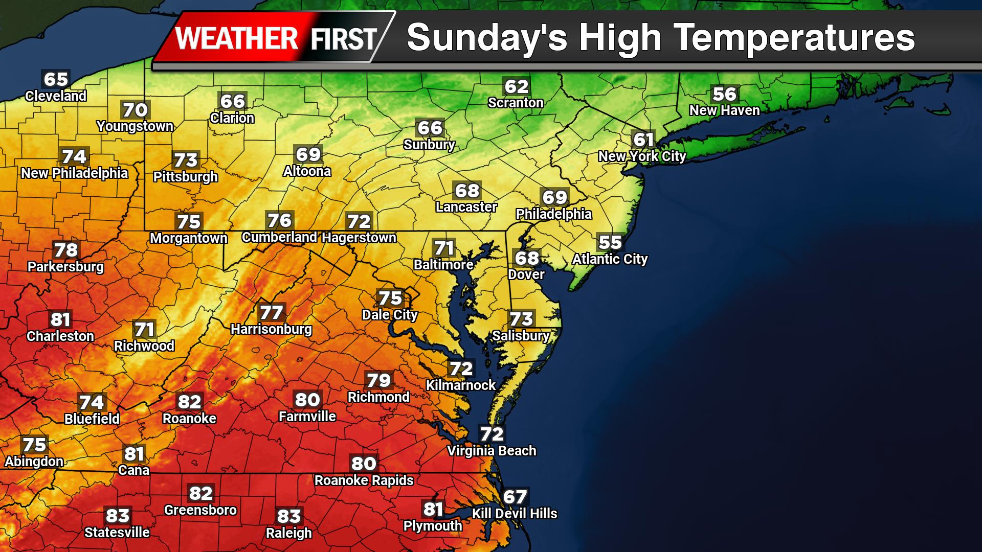
High pressure will keep conditions tranquil through Saturday and much of Sunday, with a steady warming trend underway. Afternoon highs on Saturday will reach the mid 50s to low 60s, followed by a milder night with lows only dropping into the low 40s. By Sunday, temperatures will climb even higher, with much of Delmarva seeing mid to upper 60s, and some locations potentially approaching or even reaching 70 degrees.
Clouds will begin to increase later Sunday as the next weather system approaches from the west. Showers are expected to develop Sunday afternoon and continue into Sunday night as a cold front moves toward the region. While widespread severe weather is not expected, there is enough atmospheric instability for a few isolated rumbles of thunder.
Rain chances across Delmarva will be somewhat lower compared to areas farther north, but periods of showers are still likely before tapering off by Monday afternoon as the cold front clears the coast.
Behind the front, a sharp change in conditions is expected. Colder air will quickly move in on Monday, with temperatures likely holding steady or even falling during the day. At the same time, gusty northwest winds will develop, with gusts potentially reaching 30 to 40 mph, creating a noticeably chillier feel.
The colder pattern will continue into Monday night, with temperatures dropping into the 20s and 30s, followed by highs only in the mid to upper 40s on Tuesday.
Looking ahead, temperatures will gradually moderate through the middle of next week, with additional chances for light rain returning by Wednesday into Thursday.
A mild but breezy day is unfolding across the Delmarva Peninsula as a fast-moving weather system tracks north of the region, bringing increasing winds, warmer temperatures, and a chance for evening showers.
Southerly winds are strengthening through the afternoon as the pressure gradient tightens ahead of an approaching cold front. Wind gusts are expected to reach 25 to 35 mph, especially during the mid to late afternoon hours. These gusty conditions are being driven by a strengthening low-level jet and improved daytime mixing, allowing stronger winds aloft to reach the surface.
Temperatures are responding accordingly, climbing into the lower to mid 60s inland, marking a noticeable warm-up compared to recent days. However, areas along the immediate coast will remain cooler due to persistent onshore flow off the still-chilly Atlantic waters.
Clouds will continue to increase through the day, with showers developing late this afternoon and becoming more widespread this evening as a weak cold front approaches. While the overall severe weather risk remains low across Delmarva, there is a slight chance of a thunderstorm, primarily west of the region. Most local impacts will be limited to periods of rain and brief heavier downpours.
Rainfall totals across Delmarva are expected to be relatively light, generally ranging from around 0.10 to 0.20 inches, though isolated higher amounts are possible in any heavier showers.
Conditions will improve overnight as the cold front pushes offshore, bringing an end to the rain and a gradual decrease in winds heading into early Saturday.
WASHINGTON — The scorching heat wave that demolished March temperature records throughout the Southwest United States represents far more than an isolated weather anomaly. Scientists say it’s the most recent example of increasingly severe weather patterns occurring as global temperatures continue rising.
Weather experts warn that unprecedented and lethal climate extremes are now appearing at unusual times and in unexpected locations, placing more communities at risk. While the Southwest regularly experiences dangerous heat, this wave arrived months earlier than typical, including a 110-degree reading in Arizona’s desert on Thursday that broke the nation’s highest March temperature on record.
Preliminary temperature measurements from Arizona and southern California reached 109 degrees Fahrenheit on Thursday, potentially marking the hottest March day ever documented in the United States.
“This is what climate change looks like in real time: extremes pushing beyond the bounds we once thought possible,” said University of Victoria climate scientist Andrew Weaver. “What used to be unprecedented events are now recurring features of a warming world.”
According to a Friday report from World Weather Attribution, an international team of researchers studying extreme weather causes, March’s heat wave would have been nearly impossible without human-driven climate change.
Over a dozen scientists, meteorologists and disaster specialists contacted by The Associated Press classified the March heat wave alongside ultra-extreme events including the 2021 Pacific Northwest heat wave, Pakistan’s 2022 flooding, and devastating hurricanes Helene, Harvey and Sandy.
Data from the National Oceanic and Atmospheric Administration’s Climate Extremes Index shows the portion of the United States experiencing extreme weather over the past five years has doubled compared to two decades ago, encompassing various severe conditions from heat waves to droughts and intense rainfall.
The nation now breaks 77% more hot weather records compared to the 1970s and 19% more than the 2010s, based on an Associated Press analysis of NOAA data. Billion-dollar weather disasters in recent years occur twice as frequently and cost twice as much as a decade ago, and nearly four times more than 30 years ago, according to NOAA and Climate Central records.
“It’s really hard to even keep up with how extreme our extremes are becoming,” said Climate Central Chief Meteorologist Bernadette Woods Placky. “It’s changing our risk, it’s change our relationship with weather, it’s putting more people in risky situations and at times we’re not used to. So yes, we are pushing extremes to new levels across all different types of weather.”
Government disaster management officials describe the escalating extremes as a major challenge.
Craig Fugate, who led the Federal Emergency Management Agency through 2017, observed increasing extreme events during his tenure.
“We were operating outside the historical playbook more and more. Flood maps, surge models, heat records — events kept showing up outside the envelope we built systems around. That’s just what we saw,” Fugate said via email.
He continued: “We built communities on about 100 years of past weather and assumed that was a good guide going forward. That assumption is starting to break. And the clearest signal isn’t the science debate. It’s insurers walking away.”
Climate researchers at World Weather Attribution conducted a rapid analysis examining climate change’s role in the Southwest heat wave. Comparing this week’s projected temperatures with March observations since 1900 and computer climate models, they determined that “events as warm as in March 2026 would have been virtually impossible without human-induced climate change.”
The warming caused by burning fossil fuels added between 4.7 and 7.2 degrees Fahrenheit to current temperatures, the analysis found.
“What we can very confidently say is that human-caused warming has increased the temperatures that we’re seeing as a result of this heat dome, and it’s going to be pushing those temperatures from what would have been very uncomfortable into potentially dangerous,” said report co-author Clair Barnes, an Imperial College of London attribution scientist.
Stanford University climate scientist Chris Field categorizes the Southwest heat wave as a “giant event,” with temperatures climbing up to 30 degrees above normal levels.
Field identified five similar events from the past six years: Siberia’s 2020 heat wave, the 2021 Pacific Northwest heat wave that made British Columbia hotter than Death Valley, extreme summer temperatures across North America, China and Europe in 2022, western Mediterranean heat in 2023, and a 2023 South Asian heat wave with dangerous humidity levels.
This list excludes East Antarctica’s 2022 heat wave, when temperatures soared 81 degrees above normal — the largest temperature anomaly ever recorded, according to weather historian Chris Burt, author of “Extreme Weather.”
Scientists told the Associated Press that climate-influenced severe weather extends beyond extreme heat to include destructive hurricanes, prolonged droughts and intense storms.
Catastrophic flooding struck West Africa in both 2022 and 2024. Iran continues experiencing a six-year drought. The deadly Typhoon Haiyan that devastated the Philippines in 2013 stunned global observers.
Superstorm Sandy flooded New York City and surrounding areas in 2012, generating tropical storm-force winds across nearly one-fifth of the continental United States. The storm created 12-foot waves spanning 1.4 million square miles with energy matching five atomic bombs, said Yale Climate Connections meteorologist Jeff Masters.
Recent extremes should also include wildfires intensified by heat and drought, such as 2025’s Palisades and Eaton fires, which became the nation’s costliest weather disaster last year, noted Climate Central meteorologist and economist Adam Smith.
“This is due to climate change, that we see more extreme events, and more intense ones and have so many records being broken,” said Friederike Otto, an Imperial College of London climate scientist who coordinates World Weather Attribution.
SYDNEY – Officials across Australia’s northeastern coastline issued urgent shelter warnings Friday as a powerful tropical cyclone approached the region, threatening to bring catastrophic winds, torrential rainfall, and widespread flooding.
Tropical Cyclone Narelle was positioned approximately 19 miles offshore in the Coral Sea and was forecast to strike land Friday morning as a Category 4 system, according to Australia’s meteorological agency. The storm ranks just one level below the most dangerous Category 5 classification.
Bureau of Meteorology forecaster Angus Hines warned ABC News that the cyclone could generate wind speeds reaching 155 miles per hour, powerful enough to tear trees from the ground and turn loose objects into dangerous projectiles.
“Winds of that speed are pretty hard to imagine if you haven’t experienced them before. They are just so, so strong,” Hines said during his ABC News interview.
“Obviously that puts a lot of branches and debris into the air flying around that can become really dangerous,” he added.
Weather officials predicted the cyclone would reach shore before 9 a.m. local time Friday and then lose intensity as it moves inland across the Cape York Peninsula during the following 18-hour period.
The storm is anticipated to regain strength, however, after moving over the warm waters of the Gulf of Carpentaria, where it will likely rebuild into a severe tropical cyclone before striking the Northern Territory on Saturday, according to Hines.
Emergency alerts have been issued along a 370-mile section of Far North Queensland, an area where roughly 300,000 people live. Weather authorities also cautioned that heavy precipitation could impact popular tourist destinations near the Great Barrier Reef.
Meteorologists issued warnings Thursday that an unprecedented winter heat wave gripping the Southwest will persist through the weekend, following Wednesday’s remarkable temperature milestone in a small California desert town.
The community of North Shore, California, registered 108 degrees (42.2 Celsius) on Wednesday, matching the nation’s highest March temperature first recorded in Rio Grande City, Texas, back in 1954. Meanwhile, the desert town of Thermal, located northeast of San Diego, could see temperatures soar to 110 degrees (43.3 C) on Friday.
Even nighttime brought little respite from the extreme conditions. Phoenix established a new overnight low temperature record for March 19th, with thermometers never dropping below 69 degrees (20.5 C), the National Weather Service reported. Thursday’s daytime temperatures in Phoenix are expected to peak around 105 degrees (40.5 C), with Friday potentially bringing even more intense heat. “For some perspective, the average first 105 degree day of the year normally occurs on May 22nd,” the weather service noted. The last occurrence of triple-digit March temperatures in Phoenix happened nearly four decades ago.
Multiple cities across the region shattered temperature records on Wednesday, experiencing their most intense March heat in 40 years, weather officials confirmed.
Las Vegas soared to 99 degrees (37.2 C), obliterating its previous March benchmark of 93 degrees (33.8 C) established in 2022.
In downtown Los Angeles, thermometers climbed to 94 degrees (34.4 C), surpassing the former daily record of 87 degrees (30.5 C) from 1997.
The resort city of Palm Springs, California, registered 104 degrees (40 C), equaling its warmest March temperature previously recorded in 1966.
The Southwest region will experience temperatures 20 to 30 degrees higher than typical March averages through the remainder of the week before conditions begin moderating Sunday. Weather forecasters predict numerous cities throughout the area may witness their earliest 100-degree (37.8-plus C) days in recorded history.
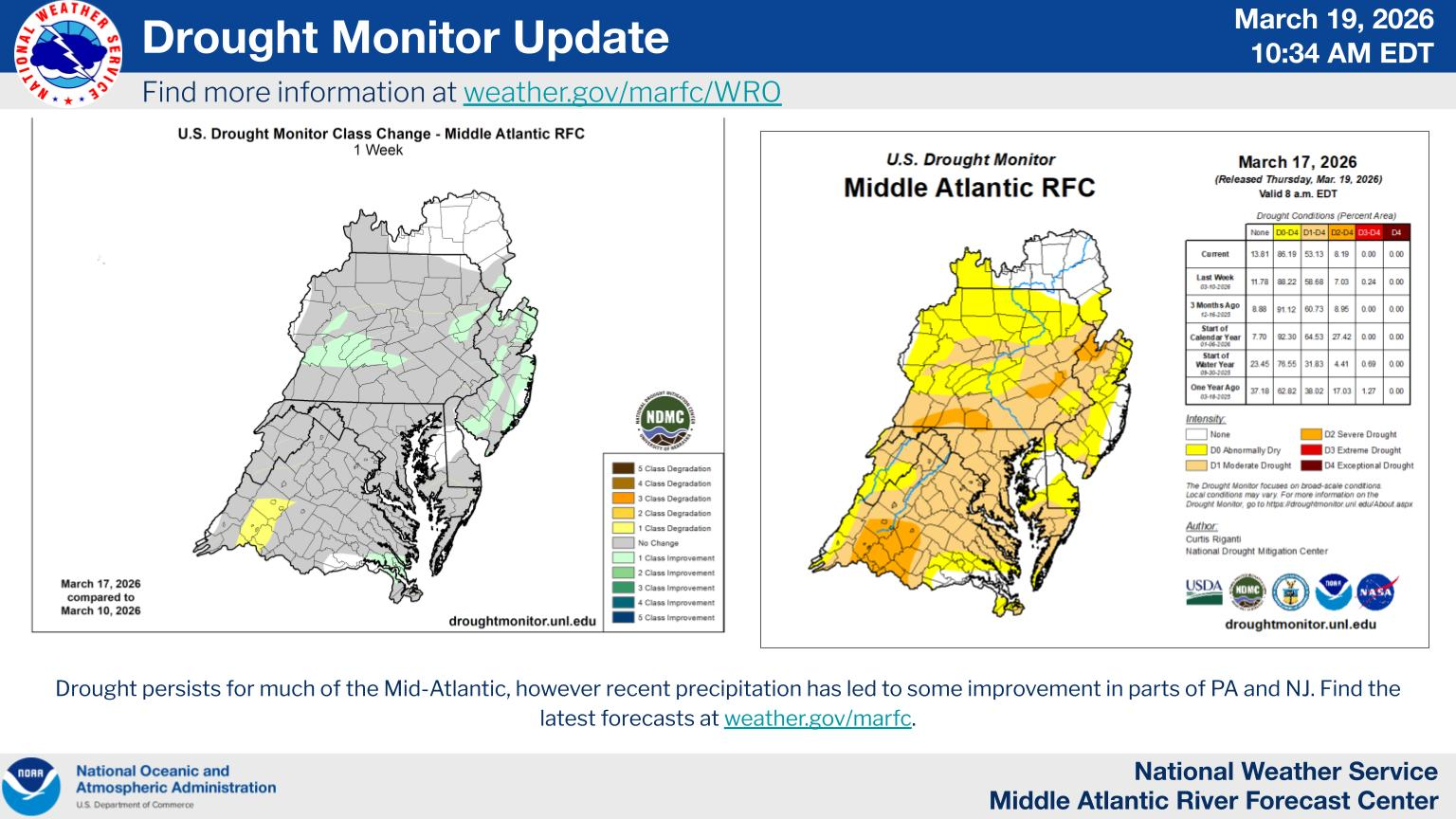
The latest U.S. Drought Monitor outlook shows a split pattern across the Mid-Atlantic, with some areas seeing improvement after recent rainfall, while others continue to dry out amid persistent warmth and long-term precipitation deficits.
Rain Brings Limited Relief to Northern Areas
Across the northern Mid-Atlantic, including Pennsylvania, New Jersey, and parts of Maryland, a widespread 0.5 to 2 inches of rainfall over the past week has helped improve drought conditions in some locations.
Locally higher amounts, topping 2 to 3 inches, were recorded in central and northeastern Pennsylvania and surrounding areas. This rainfall helped boost groundwater levels and ease longer-term precipitation deficits, allowing for modest improvement in drought classifications.
However, the relief has been somewhat tempered by unseasonably warm temperatures, which ran 9 to 12 degrees above normal across much of the region. These warmer conditions increase evaporation rates, limiting how effective the rainfall is in fully recharging soil moisture.
Drying Concerns Growing to the South
Farther south into Virginia and the broader Southeast, drought conditions are becoming more concerning.
In west-central Virginia, severe drought has expanded as soil moisture remains depleted and longer-term rainfall deficits continue to worsen. The same above-normal temperatures have only accelerated drying, increasing stress on soon to be planeted vegetation and water resources.
While isolated rainfall in parts of North Carolina brought minor improvement, it was not enough to significantly change the broader dry pattern.
Wider Regional Context
The Mid-Atlantic sits between two contrasting regimes:
To the north: Periodic storm systems are providing temporary relief
To the south:Persistent dryness and heat are driving worsening drought conditions
This transition zone places areas like Maryland and Delaware in a more uncertain position, where short-term rainfall may help, but longer-term deficits remain a concern heading into the spring growing season.
What This Means Going Forward
Despite recent rainfall in some areas, the overall trend suggests that consistent, widespread precipitation will be needed to fully reverse developing drought conditions.
If the current pattern of above-normal temperatures and inconsistent rainfall continues, parts of the Mid-Atlantic could see further drought expansion as we move deeper into spring.
For now, the region remains in a fragile balance, with improving conditions in some locations, but increasing drought pressure just to the south that could easily expand northward in the coming weeks.
After a stretch of cooler conditions, temperatures across the Delmarva Peninsula are set to moderate heading into the end of the week, with a brief taste of spring expected this weekend before cooler air returns early next week.
A warm front lifting through the region on Thursday will begin the transition, allowing temperatures to rebound into the upper 40s to low 50s. This marks a return to more seasonable conditions across Delaware and the Eastern Shore of Maryland.
The warming trend continues Friday as a stronger system passes north of the region. Southerly winds will increase, helping push highs into the upper 50s to near 60 degrees across much of Delmarva. A weakening cold front associated with this system will move through Friday night, bringing a period of light rain. Rainfall amounts are expected to remain on the lighter side, generally around a tenth to a quarter inch.
Heading into the weekend, conditions turn even milder. Saturday looks partly to mostly sunny with highs climbing into the low to mid 60s. By Sunday, even warmer air surges into the region ahead of the next approaching system, with temperatures reaching the mid to upper 60s inland. Coastal areas may stay slightly cooler due to onshore flow and the influence of colder ocean waters.
Another cold front is expected to cross Delmarva late Sunday into Sunday night, bringing a second round of scattered rain showers to end the weekend.
Behind this system, cooler Canadian air filters back into the region early next week. While temperatures will drop back closer to seasonal averages, conditions look dry and stable through at least midweek.
Overall, Delmarva will experience a classic early spring pattern: a brief warm-up with passing systems bringing light rain, followed by a return to cooler, quieter weather.
A small desert town in Southern California experienced scorching 108-degree temperatures on Wednesday, matching the hottest March reading ever documented across the United States.
North Shore, California now shares this extreme weather milestone with Rio Grande City, Texas, which first established the record back in 1954. The blistering heat is occurring during an unprecedented winter heat wave sweeping the Southwest region, with forecasters warning temperatures could climb even higher through the weekend.
Weather experts predict the nearby community of Thermal, California could see temperatures soar to 110 degrees by Friday, potentially setting a new national March record.
Phoenix, Arizona also made weather history Wednesday when thermometers climbed to 101 degrees – the earliest triple-digit reading ever recorded in the desert city. The National Weather Service reports this surpassed the previous early-season record of March 26, 1988, marking only the second time Phoenix has seen 100-degree weather during March.
National Weather Service meteorologist Bryan Lewis described the current conditions as extraordinary. “We’ve broken so many records yesterday and even today we’ve broken quite a few so far,” Lewis stated. He characterized this as among the most remarkable March heat waves ever documented.
Multiple Southwest cities experienced their warmest March day in nearly four decades on Wednesday, according to weather officials.
Las Vegas shattered its March temperature record by reaching 99 degrees, far exceeding the previous high of 93 degrees set in 2022.
Los Angeles recorded 94 degrees downtown, surpassing the former daily record of 87 degrees from 1997.
Palm Springs, California hit 104 degrees, equaling its hottest March temperature originally recorded in 1966.
The National Weather Service forecasts temperatures will remain 20 to 30 degrees higher than typical March averages throughout the Southwest for the remainder of the week before moderating slightly during the weekend. Many additional regional cities are expected to record their earliest 100-degree days in history.
Emergency crews and volunteers have now spent a full week fighting devastating wildfires across Nebraska’s western and central regions, with the largest blaze becoming a record-breaker for the state while claiming one life and destroying vast stretches of rangeland.
Coalition spokesman David Boyd explained Wednesday’s changing conditions: “What’s different today is the wind will be less — still, with gusts to 30 miles an hour — but we’re starting to dry out and heat up again. If we get fire, you know, across the containment line, it’s got the potential for rapid spread.”
Governor Jim Pillen offered a brief update while visiting the affected areas, posting on Facebook: “We are making progress, but the fight isn’t over.”
The destruction spans approximately 1,300 square miles across four distinct fires — an area exceeding Rhode Island’s total size. The most devastating blaze, known as the Morrill County fire, has ravaged roughly 1,005 square miles across five counties, extending over 80 miles from Bridgeport in the Nebraska Panhandle eastward to Lake Ogallala, establishing it as Nebraska’s most extensive wildfire on record.
Powerful wind gusts exceeding 60 mph began driving the fires across the region’s terrain last week, feeding on bone-dry prairie vegetation and red cedar groves. The blazes burned without containment for several days until Tuesday, when calmer winds combined with precipitation allowed firefighting teams to begin controlling the flames. Despite this progress, the Morrill County fire remained just 16% contained by Wednesday afternoon.
The Cottonwood fire ranks as the second-largest incident, consuming over 205 square miles after igniting approximately 10 miles southeast of North Platte. Boyd reported this fire reached 40% containment by Wednesday.
Two additional fires burning further north have proven more manageable, covering about 56 square miles and 27 square miles respectively, with both largely contained by Wednesday.
The fires have claimed at least one life — an 86-year-old woman from rural Arthur who died at her residence Thursday while attempting to flee the approaching flames, according to Pillen’s weekend news conference statement.
Numerous buildings have been destroyed, and authorities evacuated at least one residential community near Jeffrey Reservoir in the Cottonwood fire zone since last weekend.
Boyd described the challenging terrain around that evacuation area: “That area is forested with red cedar, and so that holds fire more. That’s a little more complex to fight fire in. We actually have hand crews in there that are cutting fire line in with chainsaws, you know, pretty close to the edge of what was burning.”
The agricultural impact presents long-term concerns for cattle operations throughout the region. Nebraska Agriculture Department Director Sherry Vinton highlighted during Saturday’s news conference that the Morrill County fire zone alone supports grazing for over 35,000 cattle. Agricultural specialists warn that several growing seasons may be required before the scorched land can support livestock grazing again.
Current firefighting strategies involve creating trenches around the fire perimeters and extinguishing remaining hot spots within established boundaries. Officials anticipate significant progress Thursday and Friday when lighter winds are forecast. However, Saturday’s weather outlook brings renewed wildfire risks with stronger winds returning alongside potentially record-breaking temperatures near 90 degrees.
These Nebraska wildfires represent part of a broader pattern of extreme weather affecting the nation this week, including intense heat across California and severe storms that swept the East Coast, resulting in approximately 4,000 flight cancellations nationwide on Monday.
...NWS Damage Survey for 03/16/26 New Windsor, MD Tornado...

.New Windsor, MD Tornado...

Rating:                 EF-0
Estimated Peak Wind:    80 mph
Path Length /statute/:  1.68 miles
Path Width /maximum/:   150 yards
Fatalities:             0
Injuries:               0

Start Date:             03/16/2026
Start Time:             12:02 PM EDT
Start Location:         2 SSE Linwood / Carroll County / MD
Start Lat/Lon:          39.53609 / -77.12975

End Date:               03/11/2026
End Time:               12:05 PM EDT
End Location:           2 ESE Linwood / Carroll County / MD
End Lat/Lon:            39.55740 / -77.11459

Survey Summary:

A line embedded supercell developed and tracked over north-central
Maryland during the late morning into early afternoon hours on
Monday, March 16, 2026. This storm was part of a much larger system
that brought multiple rounds of severe weather to much of the
eastern United States.

Rotation was evident within the storm around 2000 to 3000 feet above
ground on the KLWX WSR-88D radar, prompting a Tornado Warning as the
storm moved from Frederick into Carroll County. The FAA TDWR TBWI
showed this rotation quickly strengthen and lower to below 2000 feet
just to the southeast of the mid-level mesocyclone being sampled by
the KLWX WSR-88D. The tightened lower-level rotation persisted on
TBWI for 1 to 2 minutes after the mid-level rotation on KLWX had
notably weakened.

It was beneath the tightening low-level rotation at around 12:02 PM
EDT that the first evidence of tornadic damage was found. Several
trees in a weakened state just southeast of the intersection of
Hawks Hill Road and Beth Way snapped near the trunk, and fell toward
the east, west, and north. The parent storm motion was northeast.
The trees that fell were only around 100 feet apart at most, with an
undisturbed landscape around it indicating an initially very narrow
vortex perhaps no larger than about 25 to 50 yards in width.

The tornado then crossed through open fields, lifting the south end
of a long irrigation system and rolling it about 100 feet toward the
north just east of Winters Church Road.

After this, the circulation continued northeastward crossing several
more fields and groves of trees, as well as Little Pipe Creek. The
next visible and accessible damage was noted as the tornado
approached and crossed MD-75 Green Valley Road near the intersection
with MD-84 Union Bridge Road. Here, a couple dozen trees fell in
opposing directions (southeast, northeast, east, northwest, and
north). One large tree toppled onto power lines taking down a power
pole and briefly trapping a motorist between the downed wires, pole,
and downed trees. Several large pine trees at the intersection had
their tops sheared off, falling toward the north, northeast, and
east. Two trees on a hill just east of Mill Dale Lane fell toward
the north-northwest, likely just outside the circulation but in its
inflow as it passed across MD-84 Union Bridge Road. Meanwhile, an
outbuilding just to the southwest of MD-75 Green Valley Road
suffered a near total roof collapse, with the west-northwest facing
walls partially collapsed inward. Similar to the trees off Mill Dale
Lane, this outbuilding may have been just outside the tornadic
circulation, with the damage a result of inflow winds into the
vortex as it passed. It is at this point where the tornado reached
its largest and strongest, with an estimated path width of 150 yards
and peak winds of 80 mph. Despite the extent of the damage, only
about one-third of the trees in its path at this point sustained
visible damage, with no other visible damage to other outbuildings
or the farmhouse at the nearby farm.

A video taken from the Carroll County Emergency Operations Center
showed a swiftly rotating lowering, likely the tornado in progress
as it approached and crossed the intersection of MD-75 Green Valley
Road and MD-84 Union Bridge Road, just northwest of their facility.
Although trees in the foreground obstructed the view and could not
confirm ground contact, the video was directly coincident with radar
and the observed (convergent) damage.

A few trees had their tops snapped off just northeast of MD-84 Union
Bridge Road, but no visible damage was noted beyond this point. It
is possible, based on the rotation signature on TBWI, that the
tornado could have persisted for up to another mile over open
fields, but the path length in this survey can only confidently
conclude a path up to this point, approximately 1.68 miles in length.

The National Weather Service Baltimore/Washington Weather Forecast
Office thanks Carroll County Office of Emergency Management for
their assistance. Additionally, thanks to the trained spotters,
media, and public that sent in reports of damage.

EF Scale: The Enhanced Fujita Scale classifies tornadoes into the
following categories:

EF0.........65 to 85 mph
EF1.........86 to 110 mph
EF2.........111 to 135 mph
EF3.........136 to 165 mph
EF4.........166 to 200 mph
EF5.........>200 mph
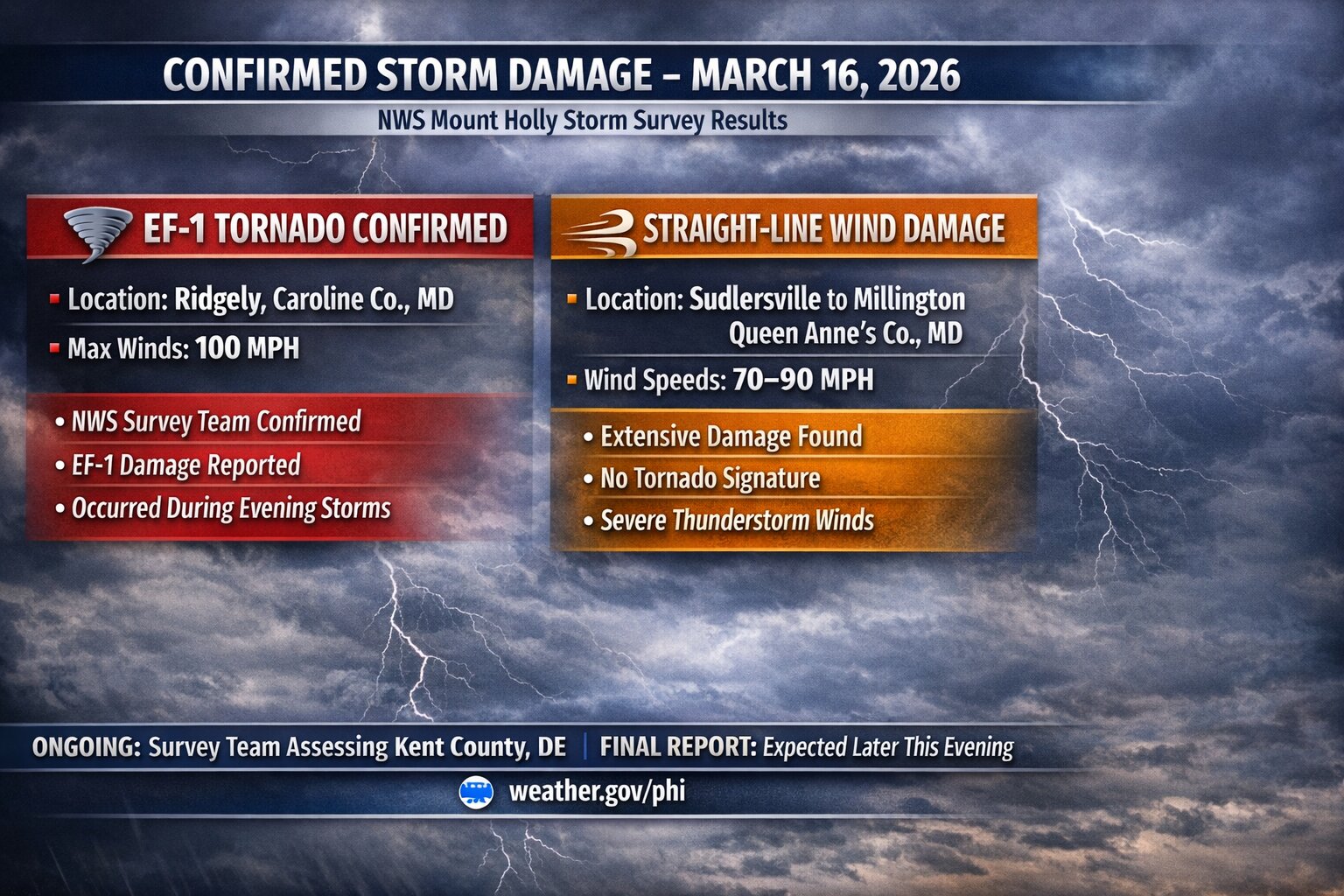
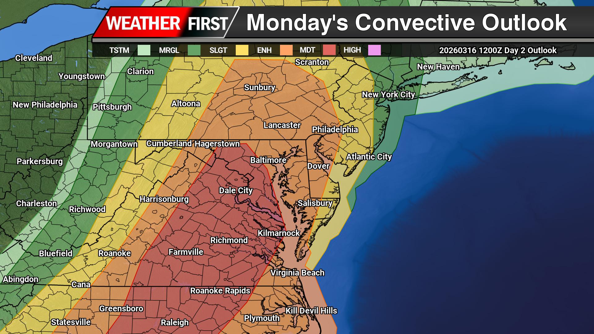
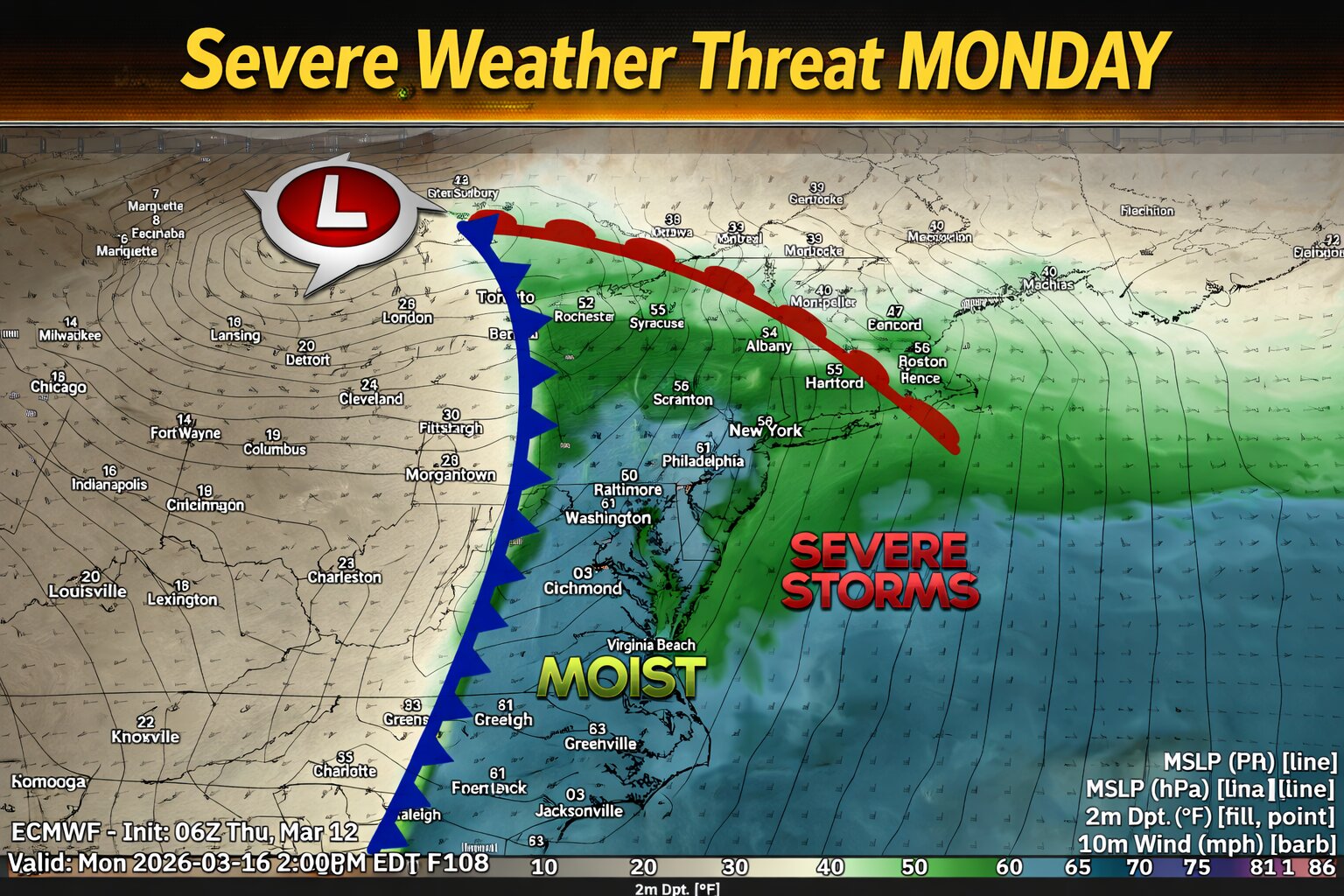
A powerful line of storms swept across the Delmarva region Monday evening, leaving behind a trail of damage now confirmed by the National Weather Service as a mix of tornadoes and destructive straight-line winds.
According to storm survey teams from the National Weather Service in Mount Holly, New Jersey, at least two EF-1 tornadoes touched down in the region, along with several corridors of intense wind damage reaching up to 100 mph.
One tornado was confirmed near Ridgely, Maryland, where winds between 90 and 100 mph carved a nearly one-mile path. Significant damage was reported, including a barn that was completely destroyed, debris thrown hundreds of yards, and numerous large trees uprooted or snapped.
A second EF-1 tornado was confirmed near Frederica, Delaware, with a shorter path of about 0.7 miles. Damage in this area was primarily to trees, along with a shed that was destroyed after being struck by a falling tree.
In addition to the tornadoes, multiple areas experienced intense straight-line wind damage, some of which rivaled tornado strength.
Photo from Magickal Mal
Near Camden, Delaware, winds were estimated between 90 and 100 mph, where several trees were snapped and fell onto mobile homes. One injury was reported in this area.
Further west in Queen Anne’s County, Maryland, a large swath of wind damage stretched nearly two miles from near Sudlersville toward Millington Road. Here, winds between 80 and 90 mph snapped power poles, tore metal roofing from farm buildings, and caused widespread tree damage.
Another concentrated pocket of wind damage was observed just south of Ridgely, Maryland, where winds up to 90 mph destroyed part of a farm outbuilding and scattered debris across nearby fields.
Outside of these hardest-hit areas, much of the region experienced widespread wind damage in the 60 to 70 mph range, consistent with the passage of a strong cold front.
Fortunately, no fatalities were reported, though the storms serve as a reminder of how quickly severe weather can intensify across the Mid-Atlantic.
The National Weather Service notes that this information remains preliminary and could be refined further as additional analysis is completed.
After a stretch of below-normal temperatures, conditions across the Delmarva Peninsula are set to gradually improve heading into the end of the week and the upcoming weekend. However, this warming trend will come with a few weak weather systems bringing occasional chances for light rain before cooler air returns early next week.
Through Thursday, quiet weather will dominate the region. Expect a mix of clouds and dry conditions, with temperatures remaining below average for mid-March.
A transition begins Thursday as a warm front lifts northward across Delmarva. This will allow temperatures to rebound closer to seasonal norms, rising roughly 7 to 10 degrees compared to midweek levels. Despite the warming trend, this system is not expected to produce any precipitation locally.
By Thursday night, a weak cold front passes to the north of the region. While this system may bring light rain and even some snow well north and west of the I-95 corridor, Delmarva will likely only see minimal impacts, with perhaps a spotty shower at most.
The warming trend continues into Friday as that boundary lifts back north. Temperatures will climb a few degrees higher, with another weak system approaching Friday night. This could bring a slight chance of light rain, but once again, the better chances for measurable precipitation appear to stay north and west of the peninsula.
Heading into the weekend, warmer air becomes more firmly established. By Saturday and especially Sunday, much of Delmarva is expected to see temperatures rise into the middle to upper 60s, providing a noticeable break from the recent chill.
The next more organized system arrives late Sunday into Sunday night, as a cold front pushes through the region. This will bring a better chance for scattered showers across Delmarva before moving offshore.
Behind this front, cooler and drier air returns to start the new week. Temperatures will fall back to more seasonable levels on Monday, with a reinforcing push of colder Canadian high pressure arriving by Tuesday. This will bring another period of below-normal temperatures to the region.
Overall, the pattern remains relatively quiet, with no significant storms expected, but periodic light rain chances and temperature swings will define the forecast over the next several days.
SAN FRANCISCO (AP) — An extraordinary winter heat wave is blasting through the western United States, delivering record-threatening temperatures across a vast region spanning from California into the desert Southwest. The typically fog-shrouded city of San Francisco, known for its characteristically cool climate even during summer months, is witnessing residents peeling off winter clothing and gathering at popular outdoor spots like Crissy Field as the area endures its warmest March weather in more than 20 years.
___
This represents a photo gallery assembled by AP photo editors.
...CONFIRMED EF-1 TORNADO IN KENT COUNTY DELAWARE...

The survey team from the National Weather Service office has
confirmed a tornado occurred Monday evening near Frederica,
Delaware (Kent County). The preliminary rating is an EF-1 with
estimated maximum wind speed of 100 mph.

Additional extensive wind damage near Camden Delaware remains
under review. Preliminary estimate of maximum wind speed in this
area is 100 mph. A determination if this was straight line wind or
tornado damage will be coming later.

Previously the survey team had confirmed a tornado occurred Monday
evening in Ridgely, Maryland (Caroline County). The preliminary
rating of this tornado is an EF-1 with maximum winds to 100 mph.

The survey team also examined significant wind damage that
occurred between Sudlersville and Millington in Maryland (Queen
Anne's County). The preliminary result is that extensive straight-
line winds occurred with speeds between 70-90 mph.

A final assessment including all of the details are expected to
be completed and transmitted via a Public Information Statement
on Wednesday.

The storm survey information will also be available on our
website at http://www.weather.gov/phi
SAN FRANCISCO (AP) — Residents of San Francisco shed their typical layers Tuesday as an extraordinary winter heat wave continues to break temperature records across the western United States, bringing the city its warmest March temperatures in more than two decades.
The Bay Area is approaching 90-degree highs while Phoenix expects to surpass 100 degrees this week — a milestone typically reached in early May that has never occurred before March 26. Las Vegas may also record its earliest triple-digit temperature ever in the coming days.
This stands in stark contrast to the Midwest and eastern regions, where residents continue clearing snow from powerful storms that caused thousands of flight delays this week.
At San Francisco’s Crissy Field near the Golden Gate Bridge, dog owners and sunbathers gathered to enjoy the unseasonably warm weather.
“It feels like summer already in March. That’s crazy, but I love it,” said dog walker Justyce Roliz. “The dogs, they love running in the water. They love to cool off. They’re loving it.”
Local resident Jessica Ling welcomed the warm temperatures but noted challenges: “but it’s difficult because we don’t have AC in our house. So we have our fans going, our windows open, but we try to be outside as much as we can.”
Temperature records fell throughout the Bay Area on Monday, with Tuesday’s forecasts predicting even higher readings. San Francisco International Airport registered 83 degrees Monday, while Redwood City in Silicon Valley hit 90 degrees, surpassing a 2004 record. San Jose’s 85-degree reading matched a mark established in 1914.
According to National Weather Service meteorologist Roger Gass, while such early heat is uncommon for San Francisco, it’s not unprecedented. The last occurrence was in 2005, when downtown temperatures reached a record 87 degrees on March 11 during a two-day heat wave that set the monthly record. March 2004 saw nearly a week of 80-degree temperatures.
Las Vegas meteorologist Brian Planz forecasts temperatures between 94 and 98 degrees over the next several days, with Saturday potentially reaching 100 degrees — which would mark the city’s earliest triple-digit reading. The current March record stands at 93 degrees, established in 2022.
“If people are visiting Vegas this weekend, they just need to prepare for the heat, make sure they’re hydrating,” Planz advised. “This is going to be unusual for this time of year.”
New Zealand visitor Mark Reeves was following that guidance, staying hydrated and seeking shade and air-conditioned casinos. Standing before the Bellagio fountains, he admitted the heat exceeded his expectations.
However, the weather hasn’t diminished his experience.
“For me, this is the trip of a lifetime,” he explained. “I’ve never been to the USA before and I may never get here again.”
Colorado faces particular challenges as this heat wave caps an unusually mild winter that left mountain snowpack well below normal. This snow typically supplies water to millions of residents. Denver-area water utilities have implemented or are considering lawn watering restrictions.
With temperatures expected to climb into the 80s this week, officials warn against early sprinkler use, as reduced water supplies must last through summer. Colorado utilities typically advise homeowners to wait until May before activating irrigation systems.
Aurora Water spokesperson Shonnie Cline, whose utility serves 400,000 suburban Denver residents, cautioned that late freezes could still damage prematurely activated sprinkler systems.
“The sooner you wake it up, it’s not necessarily better,” she said regarding lawn care.
..CONFIRMED EF-1 TORNADO IN CAROLINE COUNTY MARYLAND… …EXTENSIVE STRAIGHT-LINE WIND DAMAGE CONFIRMED IN QUEEN ANNE’S COUNTY MARYLAND…
A survey team from the National Weather Service office in Mount Holly, New Jersey has confirmed a tornado occurred last night in Ridgely, Maryland (Caroline County). The preliminary result is an an EF-1 with maximum winds to 100 mph. The survey team also examined significant wind damage that occurred last night between Sudlersville and Millington in Maryland (Queen Anne’s County). The preliminary result is that extensive straight-line winds occurred with speeds between 70-90 mph. The survey team is currently in Kent County, Delaware.
A final assessment including all of the details are expected to be completed and transmitted via a Public Information Statement sometime this evening. The storm survey information will also be available on our website at http://www.weather.gov/phi
The National Oceanic and Atmospheric Administration has forged a crucial partnership to maintain vital tsunami detection capabilities across the Pacific Ocean through a new funding arrangement with Alaska-based seismic monitoring operations.
Through this collaboration with the Alaska Mesonet and the University of Alaska-Fairbanks Alaska Earthquake Center, NOAA will financially support nine earthquake monitoring stations that deliver essential real-time tsunami warning data.
“Seismic stations are an important dataset for NOAA’s Tsunami Warning Centers to provide real-time warnings that save lives amid tsunamis and related hazards,” said Neil Jacobs, Ph.D., NOAA administrator. “NOAA’s National Weather Service is committed to providing the fastest hazard warnings possible to Americans.”
The partnership ensures continuous data transmission for communities across Alaska, particularly those in the Aleutian Islands where tsunami waves can reach shore in just minutes, as well as Pacific Northwest coastal areas and the broader Pacific region. NOAA’s financial support will cover essential operations including computer system upkeep, around-the-clock emergency response capabilities, data quality verification, ongoing station oversight, and facility maintenance.
Alaska’s congressional delegation praised the initiative’s life-saving potential. “The Alaska Earthquake Center is an unparalleled resource, helping to keep Alaskans safe from natural disasters—on land or at sea,” said Senator Lisa Murkowski. “In partnership with the National Tsunami Warning Center in Palmer, funding for seismic sensors in the Aleutians strengthens real-time warnings across the region. I appreciate NOAA’s work to find a solution to continue the important monitoring capacities that save lives.”
Senator Dan Sullivan emphasized Alaska’s unique vulnerability to seismic events. “The Alaska Earthquake Center is essential to keeping Alaska’s people, communities, and infrastructure safe,” said Senator Dan Sullivan. “Alaska sits in one of the most seismically active regions in the world, facing constant risk from earthquakes, tsunamis, and landslides. Our communities rely on the National Weather Service and its partners—including the Alaska Earthquake Center—for timely and accurate data, research, and monitoring that enable swift public communication and effective preparedness for all hazards.”
The partnership became official on March 1, 2026, operating under the National Weather Service’s National Mesonet Program. This initiative acquires observational information from various monitoring networks managed by private companies and state-university partnerships, enhancing NOAA’s existing observation infrastructure to strengthen weather and water forecasting models nationwide and globally.
A powerful line of storms swept across the Delmarva Peninsula late Monday night, producing widespread damaging wind gusts across both Delaware and Maryland. Reports from the National Weather Service show several locations experienced winds over 60 mph, with a few spots nearing hurricane-force strength.
The strongest wind gusts were reported in Kent County, Delaware, where both 1 NE Magnolia and SR1 at Trap Shooters Road measured peak gusts of 73 mph. Winds of that magnitude are capable of bringing down trees, damaging power lines, and causing structural damage.
Other strong reports across Delaware included 68 mph in Bethel, 66 mph at Delaware Airpark, 66 mph at Dover Air Force Base, and 61 mph at Delaware Coastal Airport. Along the coast, Lewes and Dewey Beach both reached 58 mph.
In Maryland, the highest measured gust was 67 mph near Galena in Kent County. Other notable reports included 62 mph near Rock Hall, 61 mph near Queen Anne, and several additional gusts in the 50 to 60 mph range across Caroline, Queen Anne’s, and Talbot counties.
Much of the damage from this event appears to be consistent with straight-line winds, but National Weather Service Meteorologists are also closely examining whether a few embedded tornadoes may have occurred within the line of storms, especially across Kent County, Delaware, and Caroline County, Maryland. These types of quick spin-up tornadoes can develop within a fast-moving squall line and may be difficult to distinguish from damaging thunderstorm winds based on initial reports alone.
Photos from Alyster Jay & Kyle Guesfeird
At this time, the main damage reports have involved trees down and structural damage, which can occur from either intense straight-line winds or brief tornadoes. Additional storm surveys and damage assessments may be needed to determine whether any tornadoes touched down.
Meteorologically, this event was driven by a strong cold front and a powerful line of thunderstorms that tapped into stronger winds just above the ground and brought them down to the surface. That created a widespread corridor of damaging winds across the region, with many areas experiencing severe thunderstorm-force gusts well above 58 mph.
Even outside the hardest-hit areas, many locations still reported gusts between 40 and 50 mph, adding to hazardous travel conditions and scattered damage concerns overnight.
Residents in Kent and Caroline Counties who experienced storm damage are encouraged to share reports, especially where there may be evidence of concentrated or convergent damage. That information can help determine whether the damage was caused solely by straight-line winds or if embedded tornadoes were involved.
Delaware transportation officials have shut down a portion of Route 9 after storm conditions brought down several power lines across the roadway.
The complete closure affects all traffic traveling between Dairy Farm Road and Beaver Dam Road while crews work to clear the fallen utility poles and restore safe passage.
DelDOT has not provided an estimated timeline for when the roadway will reopen to normal traffic flow. Motorists are advised to seek alternate routes until further notice.
The power line failures appear to be weather-related, though officials have not specified which recent weather event caused the infrastructure damage.
Motorists traveling on Westville Road will need to find alternative routes after a fallen tree forced officials to block traffic near the Mahan Corner Road intersection.
The Delaware Department of Transportation reports the roadway remains impassable while crews work to remove the tree blocking the travel lanes.
Drivers are encouraged to use alternate routes until the obstruction can be cleared and normal traffic flow restored to the area.
A stretch of Peterkins Road has been shut down to all traffic after trees and electrical wires came down across the roadway, according to Delaware Department of Transportation officials.
The road closure affects the section between Evergreen Drive and Haven Drive, forcing motorists to find alternate routes until cleanup crews can safely remove the debris.
DelDOT has not provided an estimated time for when the roadway will reopen to normal traffic flow. Drivers are advised to avoid the area and use alternative routes until further notice.
Weather officials from the National Weather Service’s Mount Holly, New Jersey office issued a severe thunderstorm warning on March 16th, alerting residents to dangerous weather conditions.
The warning took effect at 10:13 PM EDT on March 16th and remained in place until 11:15 PM EDT the same evening, covering just over one hour of severe weather activity.
The alert was distributed through the National Weather Service’s emergency notification system to keep the public informed of potentially hazardous storm conditions in the area.
Weather officials from the National Weather Service Mount Holly office in New Jersey issued a severe thunderstorm warning on March 16th, alerting residents to dangerous conditions in the area.
The warning went into effect at 10:07 PM EDT and remained active until 11:00 PM EDT on the same evening, giving residents nearly an hour to prepare for severe weather conditions.
The alert was part of the National Weather Service’s ongoing efforts to keep communities informed about potentially hazardous weather events that could impact public safety.
Weather officials from the National Weather Service Mount Holly office in New Jersey issued a tornado warning on March 16th at 10:45 PM EDT.
The severe weather alert remained active until 11:00 PM EDT on the same date.
The warning was part of the National Weather Service’s emergency notification system to alert residents of potentially dangerous tornado conditions in the area.
Weather officials from the National Weather Service’s Mount Holly, New Jersey office issued a severe thunderstorm warning on the evening of March 16th.
The weather alert went into effect at 11:10 PM EDT on March 16th and remained active until 11:45 PM EDT that same night, lasting approximately 35 minutes.
The warning was part of the National Weather Service’s ongoing efforts to alert residents about potentially dangerous weather conditions in the region.
Local residents received a severe thunderstorm warning from the National Weather Service’s Mount Holly, New Jersey office on the evening of March 16th.
The weather alert was issued at 10:44 PM EDT and remained active until 11:15 PM EDT on the same date.
The warning originated from the National Weather Service facility in Mount Holly, which monitors weather conditions for the region and issues alerts when dangerous conditions develop.
Weather officials have issued a severe thunderstorm watch for the region, warning residents to prepare for potentially dangerous storm conditions.
The National Weather Service office in Mount Holly, New Jersey issued the alert on March 16th at 11:03 PM Eastern Daylight Time. The watch will remain active until 12:00 AM EDT on March 17th.
Residents should monitor weather conditions closely and be prepared to take shelter if severe thunderstorms develop in their area during the watch period.
Weather officials from the National Weather Service’s Mount Holly, New Jersey office issued a severe thunderstorm warning on the evening of March 16th.
The weather alert went into effect at 10:56 PM EDT and remained active until 11:15 PM EDT on the same date.
The warning was distributed through the agency’s official alert system to notify residents of potentially dangerous weather conditions in the area.
Weather officials issued a tornado warning on the evening of March 16th, alerting residents to take immediate precautions.
The National Weather Service office in Mount Holly, New Jersey, issued the warning at 10:55 PM on March 16th. The alert remained active until 11:15 PM that same night.
Tornado warnings are issued when a tornado has been spotted or indicated by weather radar, requiring immediate protective action from residents in the affected area.
Weather officials from the National Weather Service’s Mount Holly, New Jersey office issued a severe thunderstorm warning on March 16th, alerting residents to dangerous weather conditions.
The warning took effect at 10:52 PM EDT on March 16th and remained active until 11:45 PM EDT the same evening, lasting nearly an hour.
The alert was designated with the official identifier urn:oid:2.49.0.1.840.0.55ddedb57186f4fb72b27a043eadd2e2feed881f.002.1.cap in the National Weather Service alert system.
The National Weather Service office in Mount Holly, New Jersey issued a tornado warning on March 16th that remained in effect for approximately 31 minutes during the evening hours.
The warning was activated at 10:44 PM Eastern Daylight Time and continued until 11:15 PM on the same date, according to official weather service records.
The alert was distributed through the National Weather Service’s emergency notification system as part of their severe weather monitoring and public safety protocols.
Weather officials from the National Weather Service’s Mount Holly, New Jersey office issued a severe thunderstorm warning on the evening of March 16th, alerting residents to dangerous storm conditions in the area.
The warning went into effect at 10:39 PM on March 16th and remained active until 11:30 PM the same evening, giving residents nearly an hour of advance notice about the approaching severe weather.
The alert was distributed through the National Weather Service’s official warning system, which uses a standardized identification protocol to track and manage weather advisories across the region.
Residents were advised to monitor local conditions and take appropriate safety precautions during the warning period as the severe thunderstorm moved through the area.
Weather officials from the National Weather Service’s Mount Holly, New Jersey office issued a severe thunderstorm warning on March 16th, beginning at 10:34 PM Eastern Daylight Time.
The warning remained active until 11:45 PM EDT on the same date, providing residents with over an hour of advance notice about potentially dangerous weather conditions.
The alert was distributed through the official National Weather Service alert system, which provides critical weather information to communities across the region.
Weather officials from the National Weather Service office in Mount Holly, New Jersey activated a tornado warning on March 16th during the evening hours.
The warning went into effect at 10:37 PM Eastern Daylight Time and remained active until 11:00 PM EDT on the same date.
The Mount Holly National Weather Service office, which provides weather forecasts and warnings for portions of New Jersey, issued the alert as part of their severe weather monitoring responsibilities.
Tornado warnings are issued when weather radar indicates rotation in thunderstorms or when trained spotters report tornado activity in the area.
Weather officials issued a severe thunderstorm warning for the region on March 16th, alerting residents to dangerous weather conditions moving through the area.
The National Weather Service office located in Mount Holly, New Jersey released the warning at 10:32 PM on March 16th, with the alert scheduled to remain active until 11:00 PM that same evening.
The 28-minute warning window provided residents with advance notice of the approaching severe weather system that posed potential threats to the region during the late evening hours.
Weather officials issued a tornado warning for a brief period on the evening of March 16th, alerting residents to potentially dangerous conditions.
The National Weather Service facility in Mount Holly, New Jersey activated the tornado warning at 10:30 PM Eastern Daylight Time on March 16th. The emergency weather alert remained active until 11:00 PM EDT the same night, spanning a 30-minute timeframe.
The warning was distributed through the official weather alert system, providing residents with advance notice of the severe weather threat in the affected area.
Weather officials from the National Weather Service’s Mount Holly, New Jersey office issued a severe thunderstorm warning on the evening of March 16th.
The warning went into effect at 10:24 PM EDT and remained active until 11:45 PM EDT on the same date.
The alert was distributed through the National Weather Service’s official alert system to notify residents of potentially dangerous weather conditions in the affected areas.
The National Weather Service office in Mount Holly, New Jersey has issued a severe thunderstorm watch beginning at 8:23 PM on March 16 and continuing until midnight on March 17.
The weather alert warns residents to remain vigilant for dangerous storm conditions that could develop during the overnight hours. Severe thunderstorms can produce damaging winds, large hail, and heavy rainfall that may lead to flooding.
Residents should monitor local weather conditions closely and be prepared to take shelter if severe weather develops in their area. The watch remains in effect until 12:00 AM EDT on March 17.
Delaware residents will have the opportunity to learn about flood preparedness next week as the state observes its annual flood awareness initiative.
Governor Matt Meyer has officially designated March 16 through 20 as Delaware Flood Awareness Week, working in partnership with the Delaware Department of Natural Resources and Environmental Control (DNREC) and the Delaware Emergency Management Agency (DEMA).
As part of the week-long educational campaign, state officials will host a special webinar on Wednesday, March 19, 2026, focused on helping Delawareans prepare for potential flooding situations.
The collaborative effort between DNREC and DEMA aims to increase public awareness about flood risks and provide residents with essential information on how to protect themselves and their property during flood events.
Weather officials have put a coastal flood advisory into effect for the Delmarva Peninsula, beginning Saturday, March 16th at 3:15 PM and continuing through 2:00 AM on Sunday, March 17th.
The National Weather Service office in Mount Holly, New Jersey issued the advisory to alert residents of potential minor coastal flooding conditions along shoreline areas.
Residents in coastal communities should remain aware of possible flooding in low-lying areas near the water during this time period.
Delaware transportation officials are warning drivers about significant flooding that has made Airport Road impassable in both directions.
According to the Delaware Department of Transportation, standing water has covered the roadway between Exit 5A and Meadow Road, creating hazardous driving conditions.
Motorists are advised to find alternate routes and avoid the flooded area until conditions improve and the water recedes.
DelDOT continues to monitor the situation and will provide updates as road conditions change.
Weather officials have issued a tornado watch for the region, urging residents to remain vigilant for dangerous weather conditions through early evening hours.
The National Weather Service office located in Mount Holly, New Jersey activated the tornado watch at 4:41 PM on March 16th, with the alert remaining in effect until 7:00 PM the same day.
A tornado watch indicates that atmospheric conditions are favorable for the development of severe thunderstorms capable of producing tornadoes. Residents should monitor weather conditions closely and be prepared to take shelter if warnings are upgraded or tornado activity is spotted in their area.
The weather service recommends having a safety plan in place and staying tuned to local weather updates throughout the duration of the watch period.
Weather officials have issued a wind advisory for the Delmarva region that will remain in effect from Saturday afternoon through the early morning hours of Sunday.
The National Weather Service office in Mount Holly, New Jersey announced the advisory at 11:39 AM on Saturday, March 16th, with the warning period extending until 2:00 AM on Sunday, March 17th.
Residents across Delaware and the Eastern Shore should prepare for strong wind conditions that may impact outdoor activities and travel plans throughout the advisory period.
Local authorities encourage people to secure loose outdoor items and exercise caution when driving, especially in high-profile vehicles that may be more susceptible to wind effects.
Weather officials have issued a tornado watch for Delaware and surrounding areas, alerting residents to potentially dangerous conditions developing this afternoon.
The National Weather Service office located in Mount Holly, New Jersey activated the tornado watch at 11:30 AM on March 16th, with the alert scheduled to remain active until 7:00 PM the same day.
A tornado watch indicates that atmospheric conditions are favorable for tornado development in the specified region. Residents should monitor weather conditions closely and be prepared to take shelter if a tornado warning is issued.
Local emergency management officials encourage Delaware residents to stay informed about changing weather conditions throughout the day and have a safety plan ready in case severe weather develops.
Rehoboth Beach officials are closely tracking dangerous weather conditions expected to hit the coastal community this afternoon through tonight. The approaching storm system threatens to bring destructive winds, hail, and potentially tornado activity to the area.
City leaders are urging everyone in the community to take immediate safety precautions:
Residents and businesses should bring in or tie down any loose items including patio umbrellas, outdoor seating, and garbage containers. Those away from home are encouraged to ask neighbors to move trash bins away from curbside areas.
Officials recommend charging electronic devices now and gathering flashlights in preparation for potential electrical outages.
All beach and water recreational activities have been banned due to expected dangerous surf conditions created by the high winds.
People should stay away from the shoreline entirely, as the rough waters may cause significant beach erosion.
Drivers are advised to exercise extreme caution on roadways and never attempt to cross flooded streets.
Should electrical service be disrupted in Rehoboth Beach, the Convention Center will serve as a public shelter on Tuesday from 8:30am to 4:30pm, offering device charging stations and warmth for residents. While the Emmert Auction will proceed as scheduled, conference rooms will be available for community members who need them.
City maintenance teams are actively preparing for the storm’s impact:
Beyond today’s regular trash collection on the south side of town, three additional trucks are working to clear branches and debris from streets before the winds arrive. Residents worried about loose branches can secure them until the scheduled yard waste pickup on Wednesday.
Tuesday’s planned trash collection for the north side remains on schedule, though officials will notify residents of any changes.
City officials promise to provide updates as weather conditions develop.
For detailed weather information, residents can check the Philadelphia/Mt Holly National Weather Service. Delmarva’s power outage tracking map is available online for monitoring electrical service disruptions.
Dense fog has settled across Delaware, creating hazardous visibility conditions for motorists throughout the state, according to transportation officials.
The fog has developed with different levels of thickness in various locations across Delaware, prompting concerns about driving safety during the reduced visibility conditions.
Drivers are advised to exercise extreme caution when traveling and to reduce speeds when encountering areas where the fog has significantly limited visibility on roadways.
The National Weather Service office in Mount Holly, New Jersey has issued a coastal flood advisory affecting Delaware’s coastal regions, beginning Saturday, March 16 at 4:20 AM and continuing until Sunday, March 17 at 2:00 AM.
Weather forecasters are warning residents and visitors in coastal Delaware to prepare for potential minor flooding in vulnerable low-lying areas during this timeframe.
The advisory covers shoreline communities where tidal conditions and weather patterns may combine to create flooding concerns over the weekend period.
Residents in affected coastal zones should monitor conditions closely and take appropriate precautions during the advisory period.
The National Weather Service office in Mount Holly, New Jersey has issued a wind advisory that went into effect at 2:27 AM on Saturday, March 16th and will remain active until 2:00 AM on Sunday, March 17th.
Local residents should prepare for strong wind conditions throughout the advisory period. The weather service is warning of potentially hazardous winds that could impact outdoor activities and travel plans.
Those with weekend outdoor plans should monitor conditions closely and take appropriate precautions. Loose objects should be secured, and drivers should exercise extra caution, especially in high-profile vehicles.
The advisory covers the region under the Mount Holly forecast office jurisdiction. Residents are encouraged to stay updated on current conditions as the weather situation develops.
The National Weather Service office in Mount Holly, New Jersey has issued a wind advisory for the region that took effect at 2:27 AM on Saturday, March 16th and will remain in place until 2:00 AM on Sunday, March 17th.
Meteorologists are warning residents to prepare for strong wind conditions that could impact outdoor activities and travel throughout the weekend. The advisory covers areas under the jurisdiction of the Mount Holly forecast office.
Residents are advised to secure any loose outdoor items and exercise caution when driving, especially in high-profile vehicles. The windy conditions are expected to persist for approximately 24 hours before subsiding early Sunday morning.
Delaware Department of Transportation officials have implemented temporary speed reductions along Interstate 495 as rainfall creates potentially hazardous driving conditions throughout the area.
The speed limit has been lowered to 55 miles per hour on the major highway as a safety precaution while wet weather persists. Transportation authorities routinely adjust speed limits during adverse weather events to help prevent accidents and protect motorists.
Drivers traveling on I-495 should expect the reduced speed limits to remain in effect until weather conditions improve and roadways are deemed safe for normal traffic speeds.
DelDOT encourages all motorists to exercise extra caution when driving in wet conditions, maintain safe following distances, and adjust their speed according to road conditions regardless of posted limits.
A dangerous weather system continued its march across the eastern United States Monday, bringing the threat of tornadoes and destructive winds to Mid-Atlantic communities while dumping heavy snow across the Upper Midwest.
Weather officials identified the Mid-Atlantic region and the nation’s capital as facing the highest risk for powerful winds and tornado activity. The weather front is forecast to clear the East Coast by Tuesday, ushering in much colder temperatures behind it.
This winter weather event occurs while Hawaii deals with ongoing impacts from a different storm system that brought devastating floods over the weekend.
The National Weather Service issued warnings about a line of dangerous storms carrying destructive winds moving across the eastern portion of the country. After developing Sunday, the weather system moved through the Mississippi, Tennessee and Ohio river valleys.
The storm danger was forecast to reach the Appalachian Mountains before advancing toward coastal areas, where meteorologists predicted “severe thunderstorms with widespread damaging winds and several tornadoes.”
A corridor extending from portions of South Carolina northward to Maryland faced the highest probability of experiencing the most destructive winds Monday afternoon, according to the weather service. Major cities including Raleigh, North Carolina, Richmond, Virginia, and Washington D.C. fell within this zone.
Authorities announced that schools in Raleigh and Chapel Hill, North Carolina, would remain closed Monday. Governor Josh Stein encouraged residents to activate emergency notifications on their mobile devices in advance of anticipated wind gusts reaching 74 mph.
In addition to risks to human safety and property damage, “whether it’s wind gusts from a squall line, blizzard or snow, or just wind because of the storm, you’re looking at several major airports being impacted,” explained AccuWeather senior meteorologist Tyler Roys.
A region stretching from central Wisconsin through Michigan’s Upper Peninsula was projected to receive more than 2 feet of snow, with some isolated areas on the peninsula potentially seeing even higher totals, Roys noted. Smaller snow amounts in cities like Chicago and Milwaukee were still expected to create significant problems for Monday commuters, he said.
Jim Allen, 45, a resident of the Upper Peninsula, explained that his family purchased essential supplies and he prepared to remove snow multiple times Sunday using both a shovel and snowblower.
“We’re basically prepared to just kind of hunker down for a few days if we need to,” Allen said.
Over 600 flights faced cancellation at Minneapolis-Saint Paul International Airport, based on data from FlightAware, which monitors air travel disruptions. Additional dozens of flights through Detroit were also cancelled. Chicago’s O’Hare and Midway international airports reported more than 850 cancellations combined.
More than 210,000 electricity customers across six Great Lakes states lost power Sunday, according to PowerOutage.us. Some outages began Friday when wind gusts in the area reached 85 mph. Extensive power failures were also documented in sections of Pennsylvania and Arkansas.
In Nebraska, approximately 30 National Guard personnel were sent to fight multiple wildfires burning across extensive rangeland and grassland areas, state authorities reported. Officials confirmed one fire-related death.
Rainfall persisted Sunday in Hawaii, where extensive farmland and residential areas have experienced flooding, roadways have been shut down and emergency shelters have opened. Certain areas of Maui recorded over 20 inches of rain, Maui County Mayor Richard Bissen reported through social media.
Maui County subsequently reduced an evacuation order Sunday and announced that crews were operating pumps to remove water from retention basins to maintain safe water levels.
Local resident and real estate professional Jesse Wald, who captured video footage of a coastal road collapsing Saturday, noted that other sections of the roadway were blocked by flooding, mud and debris.
“In the 20 years I’ve been here I’ve never seen this much rain,” he said.
A massive and unpredictable weather system unleashed chaos across the United States on Sunday, bringing heavy snowfall that made travel impossible in the Upper Midwest while destructive winds swept through the Plains states.
Hawaii remained under siege from dangerous flooding conditions.
Areas across the mid-South braced for powerful thunderstorms expected later in the day.
Weather experts predicted the storm system would move eastward by Monday, putting mid-Atlantic regions and the nation’s capital at highest risk for powerful winds and tornado activity.
Multiple waves of snow, wind and dangerous weather were positioned to strike the eastern United States, according to AccuWeather senior meteorologist Tyler Roys.
In addition to threats to human safety and property damage, “whether it’s wind gusts from a squall line, blizzard or snow, or just wind because of the storm, you’re looking at several major airports being impacted,” Roys explained.
Heavy Snow Blankets Minnesota, Wisconsin, Michigan
A region stretching from central Wisconsin to Michigan’s Upper Peninsula was forecast to receive more than 2 feet of snow, with even higher amounts possible in isolated areas of the peninsula, Roys noted. Smaller snow totals in cities like Chicago and Milwaukee were still expected to cause significant problems for Monday morning commuters, he said.
More than 20 inches of snow had already accumulated in parts of southeastern Minnesota and western Wisconsin by Sunday afternoon, based on National Weather Service data. Transportation authorities issued warnings about deteriorating conditions with poor visibility and snow-covered roads.
Wisconsin snowplow operator Aaron Haas described it as among the most severe storms he had witnessed in years. Working around Marshfield on Sunday, Haas was creating snow piles as tall as his truck.
“You can’t see anything when you’re on the highways outside of the city,” he stated.
Jim Allen, a 45-year-old Upper Peninsula resident, said his family gathered essential supplies and he prepared to clear snow multiple times Sunday using both a shovel and snowblower.
“We’re basically prepared to just kind of hunker down for a few days if we need to,” Allen explained.
FlightAware, which monitors flight disruptions, reported over 600 canceled flights at Minneapolis-Saint Paul International Airport on Sunday. Detroit also saw dozens of additional cancellations. Chicago’s O’Hare and Midway international airports, where rain and snow were forecast overnight into Monday, experienced more than 850 flight cancellations.
Landslides, Rescues, Home Collapse on Maui
Rainfall persisted Sunday in Hawaii, where vast areas of farmland and residential properties have been inundated, roadways have been shut down and emergency shelters established. PowerOutage.us, which monitors nationwide electrical disruptions, showed nearly 40,000 Hawaii customers without power by midday Sunday.
Flash flooding has created major challenges recently across Maui, Molokai and the Big Island, where precipitation was falling at rates of 1 to 2 inches per hour overnight, the Hawaii Emergency Management Agency reported.
Certain areas of Maui recorded over 20 inches of rainfall, Maui County Mayor Richard Bissen announced in a late Saturday social media update.
“We’re seeing flooding, landslides, sinkholes, debris and downed power lines across the county,” he stated. Using Hawaiian language to express appreciation, the mayor added, “mahalo for continuing to look out for one another.”
Video content accompanying Bissen’s message displayed washed-out or collapsed roadways, a vehicle trapped by floodwaters and raging waterways. National Guard personnel and fire department crews conducted numerous floodwater rescues, Bissen reported.
Tom and Carrie Bashaw said they were powerless to stop part of their Maui home in Iao Valley from collapsing under rising waters. On Friday, the water’s strength began overwhelming nearby trees.
“When we lost the mango and monkey pod, we started throwing stuff in bags and packing up,” Tom Bashaw told HawaiiNewsNow. They returned Saturday morning and “the whole backside of the house” was gone, he said.
Maui resident and real estate professional Jesse Wald, who captured video of a coastal road’s collapse Saturday, said other road sections were flooded with mud and sediment.
“In the 20 years I’ve been here I’ve never seen this much rain,” Wald said. “I’m from Wisconsin and we get thunderstorms, you know pretty often in the summer, so it felt like a Wisconsin thunderstorm but times 10.”
Maui County later Sunday reduced an evacuation notice and reported crews were removing water from retention basins to maintain safe levels.
Power Outages Continue, Some From Earlier High Winds
Over 210,000 utility customers across six Great Lakes states remained without power Sunday afternoon, PowerOutage.us data showed. Some outages began Friday when regional wind gusts reached 85 mph.
In Nebraska, approximately 30 National Guard personnel were deployed to fight multiple wildfires burning across extensive rangeland and grassland areas, state officials announced.
The three largest wildfires had affected more than 900 square miles by Saturday, officials reported. One fire-related death occurred Friday. Nebraska Governor Jim Pillen encouraged residents to follow local evacuation orders, noting that winds were “supposed to be extraordinary.”
The weather service issued high-wind warnings for most of Nebraska, with gusts up to 60 mph possible alongside falling snow. Roys said strong winds would impact an area from the U.S.-Mexico border to the Great Lakes, and from Denver east to the Appalachian Mountains.
Forecasters Issue Storm Line, Tornado Warnings
The weather service cautioned that a line of severe storms with destructive winds would cross much of the Eastern United States by late Monday. The system was set to begin Sunday afternoon and move through the Mississippi, Tennessee and Ohio valleys.
The storm threat was expected to reach the Appalachians early Monday, then advance toward the East Coast, where “severe thunderstorms with widespread damaging winds and several tornadoes” were forecast for Monday, the service stated.
An area from parts of South Carolina to Maryland appeared most likely to experience the strongest damaging winds Monday afternoon, the weather service indicated. This could affect Raleigh, North Carolina; Richmond, Virginia, and Washington D.C. An elevated but lower risk extended north to New York and south to Florida, with thunderstorms possible in New England.
Officials announced that schools in Raleigh and Chapel Hill, North Carolina would remain closed Monday and the state’s governor encouraged residents to activate emergency alerts on their phones ahead of expected wind gusts of 74 mph.
Nebraska officials are confronting an unprecedented wildfire crisis as multiple blazes have consumed over 600,000 acres statewide, marking the most destructive fire season in the state’s recorded history.
The devastating Morrill Fire, which stands as Nebraska’s largest wildfire on record, has claimed one life while destroying 460,000 acres as of Saturday, according to Governor Jim Pillen. This massive blaze, along with three additional major fires burning across central and western portions of the state, remains completely uncontained, state authorities reported.
Firefighting operations have faced significant challenges due to harsh weather conditions stemming from a powerful winter storm system affecting the Midwest. The federal National Interagency Fire Center announced Sunday it has taken control of managing the two most extensive fires – the Morrill Fire and the Cottonwood Fire.
The Cottonwood blaze has consumed over 100,000 acres according to Saturday’s joint statement from the governor’s office, Nebraska National Guard, and Nebraska Emergency Management Agency.
Governor Pillen issued an emergency declaration Friday, deploying National Guard troops and aviation resources to combat the fires. The blazes ignited Thursday amid dangerous conditions including strong winds, minimal humidity, and drought-like circumstances. By Friday, the fires had overwhelmed local firefighting capabilities, prompting the emergency response.
Collaborative firefighting efforts now include federal personnel working alongside local and state teams from Nebraska, plus additional crews from Colorado, South Dakota, and Wyoming. Fire departments from Nebraska’s largest metropolitan areas, Omaha and Lincoln, have also deployed crews following the governor’s request for assistance.
Weather forecasters predict wind speeds exceeding 50 miles per hour on Sunday, which will keep firefighting aircraft grounded. Despite snowfall from the winter storm system, officials warn the powerful winds may prevent the precipitation from providing meaningful relief to the fire zones.
As a precautionary measure, Governor Pillen has implemented a statewide prohibition on outdoor burning that will remain in effect through March 27.
A potentially dangerous severe weather outbreak is expected to unfold Monday across parts of the Southeast and Mid-Atlantic, including Virginia, Maryland, and the Delmarva Peninsula. Forecasters warn that conditions may support widespread severe thunderstorms capable of producing destructive winds and tornadoes, some of which could be strong.
The Storm Prediction Center has placed portions of the region in a Moderate Risk (Level 4 of 5) for severe thunderstorms. This level of risk is relatively uncommon and indicates a higher likelihood of significant severe weather, including the potential for strong tornadoes and widespread damaging wind events.
Powerful Storm System Moving Into the East
The severe threat will be driven by a powerful storm system developing over the central United States. An expansive upper-level trough stretching from the Midwest into the southern Plains will rapidly intensify as it moves northeast toward the Appalachian Mountains. At the surface, a deep area of low pressure over the Great Lakes will track into eastern Canada while dragging a sharp cold front across the eastern United States.
Ahead of this cold front, warm and humid air will surge northward along the East Coast. Dew points climbing into the mid to upper 60s will provide ample moisture for thunderstorm development, while strong winds throughout the atmosphere will create an environment favorable for organized severe storms.
Tornadoes and Damaging Winds Possible
Across the Southeast and Mid-Atlantic, thunderstorms are expected to develop along and ahead of the advancing cold front during the day Monday. Some storms may initially form as discrete supercells, which are capable of producing large hail and tornadoes, including the potential for strong tornadoes.
As the afternoon progresses, storms are expected to organize into a line of thunderstorms, often referred to as a quasi-linear convective system (QLCS). This type of storm structure can produce widespread damaging wind gusts, while still maintaining the potential for embedded tornadoes within the line.
Strong winds just above the surface will enhance the rotation potential within storms. Even with only modest instability, these strong wind fields could allow storms to intensify quickly and produce severe weather across a large portion of the region.
Mid-Atlantic Threat Developing During the Afternoon
Farther north into Virginia, Maryland, and nearby areas, the amount of instability remains somewhat uncertain due to possible cloud cover and earlier precipitation. However, even relatively weak instability combined with very strong wind shear may still be sufficient to support severe thunderstorms.
Storms are expected to organize into a broad line extending from parts of New York and Pennsylvania southward through Virginia and North Carolina during the midday and afternoon hours. Within this line, embedded rotating storms could produce tornadoes and pockets of intense wind damage.
Severe Threat May Diminish Near the Coast by Evening
As the line of storms pushes east toward the Atlantic coastline Monday evening, the severe threat may gradually weaken as storms interact with cooler marine air near the coast. However, damaging winds and isolated tornadoes could still occur before the storms move offshore around sunset.
Preparedness Encouraged
With the potential for widespread severe weather, residents across the region should remain alert to changing conditions Monday. Multiple rounds of storms may occur, and warnings could be issued with little lead time if tornadoes develop.
Make sure you have multiple ways to receive weather alerts and be prepared to take shelter quickly if severe thunderstorms or tornado warnings are issued.
Dangerous weather conditions created havoc across multiple regions of the United States on Sunday, as heavy snowfall blanketed areas of the Upper Midwest and destructive winds caused damage throughout the Plains states.
The unpredictable weather pattern brought a mix of hazardous conditions to different parts of the country, creating challenges for residents and emergency responders dealing with the varied threats.
A massive weather system unleashed chaos across the United States on Sunday, blanketing the Upper Midwest with heavy snowfall while powerful winds tore through the Plains states. The severe conditions even reached Hawaii, where significant flooding struck multiple areas.
Weather forecasters warned that dangerous thunderstorms developing Sunday evening in the mid-South will move eastward, creating a serious tornado and high wind threat for much of the Eastern United States by Monday. The mid-Atlantic region, particularly around Washington D.C., faces the greatest danger.
“This system is going to impact the eastern half of the United States,” explained Tyler Roys, a senior meteorologist with AccuWeather. He warned that beyond risks to people and property, “whether it’s wind gusts from a squall line, blizzard or snow, or just wind because of the storm, you’re looking at several major airports being impacted.”
By Sunday morning, snowfall exceeded 12 inches across parts of Minnesota and Wisconsin, with the National Weather Service predicting several additional inches for the Minneapolis region under active blizzard warnings.
Travel became treacherous throughout Minnesota, Michigan, and Wisconsin as transportation authorities issued alerts about dangerous road conditions, poor visibility, and snow-covered highways.
“Roads are becoming impassable in many of Wisconsin’s northern counties,” the Wisconsin Department of Transportation posted on social media. “Please stay off the roads to keep yourself and others safe.”
Air travel suffered major disruptions, with FlightAware reporting over 600 flight cancellations at Minneapolis-Saint Paul International Airport on Sunday. Detroit’s airport also saw dozens of flights scrapped.
Central Wisconsin and Michigan’s Upper Peninsula could receive more than 24 inches of snow, with some isolated areas seeing even higher totals, according to Roys. He noted that even lighter accumulations expected in Chicago and Milwaukee through Monday will likely cause significant commuter problems.
Power outages from the weekend storm remained limited as of Sunday, but approximately 150,000 customers across Ohio, Pennsylvania, and Michigan were still without electricity following Friday’s winds that reached 85 mph, according to PowerOutage.us.
In Nebraska, about 30 National Guard members were activated to battle multiple wildfires spreading across rangeland and grasslands, the state’s Emergency Management Agency announced.
The three largest fires have scorched more than 900 square miles, including the Morrill County fire that has consumed over 700 square miles, officials reported.
One fire-related death occurred Friday, prompting Nebraska Governor Jim Pillen to urge residents to heed evacuation orders. He warned that Sunday’s winds were “supposed to be extraordinary.”
The National Weather Service issued high wind warnings for most of Nebraska Sunday, with gusts potentially reaching 60 mph combined with falling snow. Roys indicated that strong winds would affect areas from the U.S.-Mexico border to the Great Lakes, stretching from Denver east to the Appalachian Mountains.
Forecasters predicted a line of severe storms with destructive winds would sweep across much of the Eastern United States by late Monday, beginning Sunday afternoon in the Mississippi, Tennessee, and Ohio river valleys.
The storm system was expected to reach the Appalachians late Sunday and early Monday before advancing toward the East Coast, where “severe thunderstorms with widespread damaging winds and several tornadoes” were forecast for Monday daytime hours.
The National Weather Service identified a zone from parts of South Carolina to Maryland as most likely to experience particularly destructive winds Monday afternoon, potentially affecting Raleigh, North Carolina; Richmond, Virginia; and Washington D.C. An elevated but lower risk extended north into portions of New York and south to northern Florida.
Meanwhile, rain continued falling across Hawaii, where flooding has inundated farmland and homes, forced road closures, and opened emergency shelters.
Flash flooding has plagued Maui, Molokai, and the Big Island in recent days, with rainfall rates of 1 to 2 inches per hour overnight, the Hawaii Emergency Management Agency reported.
Approximately 48,000 electrical customers in Hawaii remained without power as of early Sunday, PowerOutage.us data showed.
The National Weather Service office in Mount Holly, New Jersey has issued a wind advisory affecting the region, beginning Friday, March 15 at 12:47 PM and remaining in effect until Sunday, March 17 at 2:00 AM.
This extended wind advisory spans nearly 38 hours, indicating sustained periods of strong winds that could impact outdoor activities and potentially cause property damage.
Residents are advised to secure loose outdoor items and exercise caution when driving, particularly in high-profile vehicles. The advisory suggests winds will be strong enough to warrant official notification from meteorologists.
The weather service typically issues wind advisories when sustained winds or frequent gusts pose a threat to people and property, though conditions are not expected to reach warning levels.
A rapidly strengthening storm system is expected to bring the potential for strong to severe thunderstorms across portions of the Mid-Atlantic on Monday, including parts of Maryland, Delaware, and Virginia.
We are closely watching the evolving setup, which could lead to a volatile day of severe weather across the eastern United States, particularly from the Carolinas northward into the Mid-Atlantic.
The storm system will begin organizing this weekend as low pressure develops on the eastern side of the Rocky Mountains. As the system strengthens and lifts northeast toward the Great Lakes, the upper-level trough associated with it is expected to turn negatively tilted, a configuration that often signals a strengthening storm system.
By Monday morning, a warm front is forecast to lift north through the Mid-Atlantic, placing much of the region into the warm sector of the storm. This will allow warmer temperatures and increasing humidity to spread northward, with dew points rising into the 60s as southerly winds transport a deep plume of moisture into the region.
At the same time, the atmosphere will become increasingly dynamic. Forecast guidance shows strong height falls aloft and a powerful upper-level jet stream positioned over the Mid-Atlantic. These ingredients will help promote rising motion in the atmosphere and the development of thunderstorms.
While atmospheric instability may be somewhat limited due to cloud cover and early-day showers, the strength of the wind fields and large-scale dynamics could compensate for that limitation. Strong low-level wind shear ahead of the approaching cold front may allow thunderstorms to organize quickly Monday afternoon and evening.
The primary threat with these storms will be strong to damaging wind gusts, though a few tornadoes cannot be ruled out, especially if individual storms are able to form ahead of the main line of convection.
Scattered to widespread severe storms are possible across the Southeast and Mid-Atlantic on Monday. The corridor with the greatest potential for more significant severe weather currently appears to extend from South Carolina northward into Maryland, placing parts of the Mid-Atlantic near the northern edge of the higher-risk zone.
SPC Forecasters also note that this could become a very volatile severe weather day, and portions of the region from South Carolina to Maryland may even warrant an upgrade to a Level 4 Moderate Risk in later outlooks if confidence increases in the severe storm setup.
Storm modes could include a mix of discrete supercells ahead of the front as well as a fast-moving squall line. Embedded circulations within the line could enhance the tornado threat as storms move east toward the coastal plain.
In addition to the severe weather threat, the system will also bring the potential for periods of heavy rainfall. Precipitable water values are forecast to climb between 1.1 and 1.4 inches, which is above the 90th percentile for early March. While widespread flooding is not currently expected, locally heavy rain could lead to quick rises on small streams and rivers.
We will continue to refine the forecast in the coming days as the timing of the cold front and the amount of daytime heating become clearer. These factors will play a key role in determining how intense the storms become.
Residents across the Mid-Atlantic should stay weather aware on Monday and be prepared for the possibility of rapidly changing weather conditions during the afternoon and evening hours.
HARRISBURG, Pa. (AP) — A devastating windstorm swept through the Midwest on Saturday, plunging nearly half a million people into darkness and causing widespread damage to buildings and vehicles across multiple states. The powerful weather system also contributed to fatal wildfires in Nebraska’s grasslands.
By Saturday afternoon, approximately 450,000 customers remained without electricity across Ohio, Pennsylvania and Michigan, based on data from PowerOutage.us, a national outage monitoring service.
The National Weather Service recorded extraordinary wind speeds during the storm, including a 66 mph gust at Pittsburgh International Airport on Friday that ranked as the fourth-strongest non-thunderstorm wind event in the facility’s history. Even more dramatic was Cleveland Burke Lakefront Airport, where winds reached 85 mph Friday afternoon.
The fierce winds wreaked havoc on structures throughout the region. A gas station canopy collapsed in New Franklin, Ohio, while an auto parts store sign was destroyed in Baldwin, Pennsylvania. From Cleveland to Pittsburgh, fallen trees and large branches crashed into residential homes and vehicles. In Niles, Illinois, near Chicago, wind severely damaged a school building’s roof.
The same weather pattern intensified multiple wildfires across Nebraska’s ranch and grassland areas, resulting in one fatality in Arthur County, according to state officials. Authorities have not released the victim’s identity or provided additional circumstances surrounding the death.
State emergency officials are calling it the Morrill County fire, which has consumed at least 735 square miles spanning four counties since Thursday. The Nebraska Emergency Management Agency reports that a minimum of 12 buildings have been completely destroyed.
Chelle Ladely, a Sidney resident, described the frightening conditions even though her property sits roughly 40 miles from the closest fire zone. She expressed deep concern for relatives and neighbors in affected areas.
“Smoke is filling the air and at night, I can see the burn of the fires on the horizon,” Ladely said. “My father is a crop agronomist, and his company as well as other local farmers are all gathering their water trucks to help aid with the fires, and truckloads of bottled water and food is being supplied by our good patrons for our volunteer firemen trying to extinguish the blazes.”
Additional wildfires driven by winds reaching 65 mph consumed another 225 square miles by Saturday midday, bringing the total burned area to nearly 938 square miles. The Nebraska Emergency Management Agency stated that the extreme wind conditions have prevented firefighters from establishing containment lines around any of the blazes. Governor Jim Pillen conducted an aerial tour of Morrill County fire damage on Saturday.
Despite threatening weather conditions in Chicago, thousands of St. Patrick’s Day celebrants gathered to watch the traditional river dyeing ceremony and downtown parade. Snow threats and bitter winds pushed the wind chill temperature far below freezing during the festivities.
The destructive winds represent just one element of an unusual weather pattern affecting much of the country, which includes flooding rains in Hawaii, approaching triple-digit temperatures in Phoenix, and returning winter conditions to the Midwest and Northeast. Chicago temperatures are forecast to drop near single digits by Tuesday, while Minneapolis could see readings around zero degrees.
Multiple Minnesota municipalities have already issued snow emergency declarations beginning Sunday, anticipating what meteorologists believe could be the season’s heaviest snowfall. Wisconsin and Michigan’s Upper Peninsula are also expected to be significantly impacted.
AccuWeather meteorologists are characterizing the weather system as a “potent triple-threat March megastorm” that will continue from Sunday through Monday.
“It’s definitely a very active weather weekend, that’s for sure,” AccuWeather senior meteorologist John Feerick said. “It’s a highly amplified pattern, which means you get a lot of extremes. Also, not just the Lower 48, but Hawaii’s getting hit hard right now with some very heavy rain.”
Feerick warned that areas along the Wisconsin-Iowa border could experience ice formation, creating hazardous travel conditions throughout much of the Upper Midwest region.
Weather officials have issued a dense fog advisory for the region, warning residents of significantly reduced visibility conditions.
The National Weather Service office located in Mount Holly, New Jersey released the advisory on Saturday, March 9th at 7:33 PM Eastern Daylight Time. The warning will remain active until Sunday morning, March 10th at 10:00 AM EDT.
Motorists should exercise extreme caution when traveling during the advisory period, as thick fog can create hazardous driving conditions with visibility dropping to dangerously low levels.
Weather forecasters from the National Weather Service Mount Holly office have issued a dense fog advisory for the region, warning residents of hazardous visibility conditions.
The advisory took effect at 7:33 PM on Saturday, March 9th, and will remain in place until 10:00 AM on Sunday, March 10th.
Motorists are urged to exercise extreme caution during the advisory period, as thick fog can drastically reduce visibility on roadways. Drivers should reduce speed, use low-beam headlights, and maintain extra distance between vehicles.
The foggy conditions are expected to be most problematic during the overnight hours and Sunday morning commute, potentially causing delays for travelers throughout the region.
Fierce weather systems swept through the Midwest and Mid-Atlantic regions Friday, leaving nearly 400,000 customers without electricity across six states, data from PowerOutage.us revealed.
Ohio experienced the most extensive power disruptions, with approximately 123,300 residents and businesses losing service. This figure represents roughly 2.3% of Ohio’s total customer base of about 5.4 million.
Within Ohio, an American Electric Power subsidiary suffered the largest impact, with roughly 40,000 customers experiencing blackouts. AEP serves approximately 1.5 million electricity users throughout the state.
Wisconsin ranked second in outage numbers with 81,100 customers affected, while Michigan followed closely with 75,100 power losses. Indiana reported 73,700 outages, Illinois saw 30,700 customers without service, and Pennsylvania recorded 12,600 disruptions.
The combined total of power outages reached 396,500 customers as the storm system moved through the region Friday.
A potent storm system is expected to bring the potential for severe thunderstorms across the Mid Atlantic on Monday, including portions of the Delmarva Peninsula. Forecasters are becoming increasingly concerned about the risk for significant damaging winds as a powerful cold front sweeps east through the region.
The setup begins with a deep upper level trough moving out of the Mississippi Valley and toward the Great Lakes on Monday. As this system strengthens, surface low pressure will deepen while tracking north through the Great Lakes into Canada. Trailing behind the system, a strong cold front will move toward the East Coast and is expected to cross the Mid Atlantic Monday afternoon and evening.
Ahead of the front, strong southerly winds will transport warm and increasingly humid air into the region. A warm front lifting north will allow temperatures to climb into the 60s across much of the area, with some locations potentially reaching the lower 70s. At the same time, dew points will surge toward 60 degrees, creating a more unstable and moisture rich environment ahead of the approaching cold front.
Showers are expected to develop Sunday night into Monday as warm air advection increases across the region. These showers will likely become more widespread through the day Monday as the large scale storm system approaches. Even with cloud cover and showers potentially limiting instability, the atmosphere will feature very strong wind fields capable of supporting organized severe storms.
The Storm Prediction Center has highlighted the potential for an enhancement of significant damaging winds across portions of the Mid Atlantic on Monday. Forecast models show extremely strong winds just above the surface, with winds at around 5,000 feet reaching 50 to 70 knots. When thunderstorms develop along the cold front, these winds could be transported down to the surface, producing corridors of damaging wind gusts.
In addition to the wind threat, the overall wind shear profile will be very favorable for storm organization. Forecast soundings show strong turning of winds with height, which may allow storms to rotate. If storms develop ahead of the cold front in the warm sector during the afternoon, a few supercells could form. These storms would have the potential to produce isolated tornadoes, especially from the Carolinas into eastern Virginia before moving northward.
The most likely severe weather scenario, however, involves a fast moving squall line developing along or just ahead of the cold front during the afternoon and evening. This line of storms could produce widespread damaging wind gusts, with embedded tornadoes also possible due to the intense low level wind shear.
Heavy rainfall will also accompany the storms as deep moisture moves northward into the region, with atmospheric moisture values climbing above one inch of precipitable water.
Once the cold front passes Monday night, conditions will change quickly. Much colder air will surge into the region on gusty northwest winds, bringing temperatures back closer to seasonal levels for Tuesday and Wednesday.
Delaware drivers are being urged to exercise extreme caution this morning as thick fog has settled across the First State, creating hazardous driving conditions with reduced visibility.
The Delaware Department of Transportation reports that dense fog with varying levels of intensity has been spotted throughout all three counties, prompting officials to issue a travel advisory for motorists.
Visibility conditions are fluctuating across different areas of the state, making it difficult for drivers to see clearly on roadways. Transportation officials recommend reducing speed, increasing following distance, and using low-beam headlights when navigating through the foggy conditions.
Drivers should allow extra time for their commute and consider delaying non-essential travel until visibility improves. The fog is expected to impact morning travel times as commuters head to work and school.
Virtually the entire United States is experiencing or preparing for severe weather conditions as multiple extreme systems converge across the nation.
Hawaii has begun experiencing days of heavy rainfall. The Southwest is preparing for consecutive days of record-breaking temperatures exceeding 100 degrees (38 Celsius). Two storm systems are expected to deliver feet of snow across northern Great Lakes regions. Meanwhile, the polar vortex is set to bring bone-chilling Arctic temperatures to the Midwest and Eastern states.
This extreme weather forecast follows dramatic temperature swings that have already affected much of the East Coast. Washington, D.C. residents enjoyed record-breaking 86-degree Fahrenheit (about 30 Celsius) weather on Wednesday, walking around in shorts, only to see snowfall the following day.
“All of the country, even if you’re not necessarily seeing extremes, are going to see generally changing from cold to warm, or warm to cold to warm,” said meteorologist Marc Chenard of the weather service’s Weather Prediction Center in Maryland.
Former National Oceanic and Atmospheric Administration chief scientist Ryan Maue said he expects extreme weather in all 50 states.
A heat dome will establish itself early next week over the Southwest, creating triple-digit temperatures unprecedented for this time of year, according to both Maue and Chenard.
Weather predictions show Phoenix reaching 98 degrees (almost 37 Celsius) on Tuesday, followed by 103, 105 and two consecutive days of 107 degrees (almost 42 C). Phoenix’s 137-year weather history shows the city has never reached 100 degrees before March 26, typically hitting its first century mark in early May, according to the weather service, which cautioned residents: “Since we are not acclimated to this level of heat this early in the year, it will be more impactful than usual.”
Los Angeles has already begun experiencing this pattern with unusual March temperatures reaching 90 degrees, sending residents in shorts and tank tops searching for any available shade, including narrow strips cast by light poles.
Shane Dixon, 40, typically completes 5-mile runs near his Culver City home without difficulty, but Thursday’s heat forced him to cut his workout short, his face covered in sweat and his T-shirt tucked into his shorts.
“The back of my neck was melting,” he said. But he preferred it to the cold and snow that will hit elsewhere.
“I could go literally soak myself and walk out in the sun and I’ll make it home fine. If it was freezing cold I could not do this,” he said.
Simultaneously with Phoenix’s heat wave, the polar vortex — a system that typically contains frigid air near the North Pole — is predicted to push its chill deep into the Midwest and East, potentially reaching parts of the Southeast, Maue explained.
Minneapolis temperatures will drop to around zero, while Chicago will experience single digits on Tuesday. The following day will bring “temperatures in the teens and 20s in the northeast and 20s in the Mid-Atlantic,” Maue said. Atlanta could see temperatures drop into the 20s.
Two consecutive storm systems — the first arriving Friday, followed by another Sunday through Monday — will move across the nation’s northern regions and Great Lakes, potentially depositing 3 to 4 feet of snow in some areas, Maue explained.
The second, larger storm system will experience such rapid barometric pressure drops — indicating intensification and strengthening winds — that it will qualify as a bomb cyclone, an unusual phenomenon over land. While bomb cyclones typically draw energy from warm ocean waters, this system will derive power from the polar vortex.
Maue said Hawaii is getting an atmospheric river that will have such persistent heavy rain that flooding will be a major issue. Oahu is under a flash flood warning.
Alaska, normally frigid during this season, will experience temperatures approximately 30 degrees below normal, he noted.
“It is the time of year where we can see stuff like this,” Chenard said. “But this does seem even anomalous from what you would typically see. I mean, some of these areas will be setting records. Record-high temperatures for March and maybe multiple times.”
Over the past week, tornadoes have claimed at least eight lives in Oklahoma, Michigan and Indiana. While severe storm forecasts don’t appear as extensive or widespread for the coming week, dangerous thunderstorms could develop “anywhere from the Mississippi Valley toward the East Coast” on Sunday or Monday, Chenard said.
An erratic jet stream underlies these conditions, both Maue and Chenard explained.
The jet stream functions as an air river that transports weather from west to east along a roller-coaster-like trajectory. Typically, these dips resemble gentle kiddie roller coaster movements. Currently, however, the jet stream is creating nearly vertical, dramatic drops followed by steep climbs.
“Which means you get a lot of extremes next to each other,” Maue said. Pacific storm fronts encounter the high-pressure heat dome in the Southwest and get pushed northward to climb that mountainous jet stream peak, “grab access to that cold air reservoir up there” and bring it back down south down the other side of the hill, he said.
Multiple studies have linked unusual jet stream and polar vortex behavior to diminishing Arctic sea ice and human-caused climate change.
However, relief is expected.
“The first day of spring is 20th (of March), and then after that we get recovery,” Maue said.
Federal meteorologists are seeking every available piece of data when dangerous winter conditions threaten lives, prompting them to issue critical safety alerts. Among winter’s many dangers, wind-driven snow represents a frequently underestimated yet serious risk to public safety.
This weather phenomenon occurs when powerful winds pick up snow that has previously accumulated on the ground, lifting it back into the air. The result can be an immediate drop in visibility to virtually nothing, creating dangerous conditions for anyone traveling by car or plane.
Weather forecasters are now combining satellite observations with citizen reports to improve their ability to identify these hazardous conditions before they become life-threatening emergencies.
Winter weather conditions are impacting New Castle County as snowfall with different levels of intensity has been reported throughout the area.
Delaware Department of Transportation officials are urging drivers to exercise extra caution while traveling on county roads during the ongoing snow event.
The varying degrees of snowfall intensity across different parts of New Castle County may create unpredictable driving conditions for motorists.
Residents are encouraged to allow additional travel time and maintain safe following distances while the winter weather persists in the region.
SOUTHERN CALIFORNIA — Before spring officially arrives next week, residents across Southern California are experiencing summer-like conditions as meteorologists forecast extraordinarily high temperatures, with some areas expected to reach the mid-90s near Los Angeles.
Thursday and Friday will bring temperatures approximately 20 degrees above typical mid-March levels, according to the National Weather Service. Health officials are warning residents about increased risks of heat-related illnesses and recommending people stay well-hydrated while limiting outdoor activities during peak daylight hours.
This unusual winter heat surge results from a high-pressure system combined with an absence of the typical cooling ocean breezes from the Pacific, explained Bryan Lewis, a National Weather Service meteorologist stationed in Los Angeles.
“The nation’s air conditioner, as we like to call it, is essentially shut off right now,” Lewis said Thursday. “We’ll likely tie or break several temperature records all across LA County.”
Thursday is anticipated to be the most intense day of heat in the Los Angeles area, with thermometers potentially reaching 93 degrees in the downtown core and climbing to 95 degrees throughout the San Fernando Valley. Normal temperatures for this time of year hover around 70 degrees.
Construction crews working outdoors are being provided with ample drinking water and electrolyte supplements to prevent dehydration. Companies are mandating regular rest periods, according to Junior Pineda, who represents a local chapter of the International Union of Bricklayers & Allied Craftworkers.
“And there’s always shade structures, if guys start feeling a little light-headed and need to take a few minutes,” he said Wednesday.
Both Los Angeles city and county authorities have arranged to open cooling centers to assist residents who lack air conditioning in their homes.
Zack Marquez, a wheelchair user, was completing his errands Wednesday in LA’s Koreatown district before the temperature climbed too high.
“Gotta stay hydrated and stay in the shade,” he said.
Coastal areas may experience some relief Friday when ocean breezes return, though interior regions will continue experiencing sweltering conditions, weather forecasters predict.
Hollywood celebrities are arriving in Los Angeles for Sunday’s Academy Awards ceremony, with numerous events scheduled throughout the week to capitalize on the gathering of entertainment industry stars. However, the extreme heat should subside before the awards show takes place.
Other parts of California will also experience above-average temperatures beginning next week. The San Francisco Bay Area and Sacramento region could see temperatures exceeding 90 degrees by Monday.
Delaware Department of Transportation officials have implemented reduced speed limits on Interstate 495, bringing the maximum allowable speed down to 55 miles per hour due to adverse weather conditions affecting the area.
The temporary speed reduction has been put in place as a safety measure for motorists traveling along the highway during current weather patterns impacting the region.
Drivers are advised to exercise caution and follow the posted speed limits while traveling on I-495 until conditions improve and normal speed limits are restored.
A strong storm system moving from the Mississippi Valley toward the East Coast could bring the potential for severe thunderstorms across parts of the Mid Atlantic on Monday.
Ahead of an approaching cold front, warm and humid air will surge northward with dew points climbing into the 60s. At the same time, strong southwesterly winds throughout the atmosphere will overspread the region, creating favorable conditions for organized thunderstorms.
The primary threat appears to be a line of thunderstorms developing along the advancing cold front, which could produce damaging wind gusts as it moves east through the region. Even though atmospheric instability may remain somewhat limited, the strength of the storm system and strong forcing along the front could still support severe weather.
There is also a more uncertain risk for isolated supercell thunderstorms ahead of the main line, particularly across parts of eastern Virginia and North Carolina where low level wind shear may be enhanced.
The Storm Prediction Center have highlighted portions of the Mid Atlantic with a 15 percent severe weather risk Monday, mainly due to the potential for damaging winds with the line of storms. Cloud cover and early day showers may limit instability, which could affect the overall severity of the storms.
A dramatic change in the weather is unfolding across the Delmarva region today as a strong cold front moves offshore, bringing gusty winds, falling temperatures, and the potential for rain to mix with wet snow later in the day.
The region began the morning unusually warm, with temperatures starting in the 60s and even low 70s in some areas. However, strong cold air advection behind the departing cold front is causing temperatures to steadily fall through the day. Readings will drop through the 50s and 40s during the morning before settling into the mid to upper 30s by this afternoon.
Periods of showers are expected early today. As the atmosphere continues to cool, an area of additional moisture will develop behind the front as a disturbance rides along the temperature boundary offshore. This will cause rain to expand across much of the region through the late morning and afternoon hours.
As colder air deepens across the Mid-Atlantic, rain may begin mixing with wet snow, and in some places could briefly change over to all snow during the afternoon. This scenario is most likely near and southeast of the I-95 corridor, which includes much of Delaware and Maryland’s Eastern Shore.
If a band of stronger lift develops later this afternoon, precipitation could briefly intensify. This would allow the atmosphere to cool more quickly and may lead to a faster transition from rain to snow for a short period.
Despite the possibility of wet snow, little to no accumulation is expected. The recent stretch of record warmth has left ground temperatures elevated, and air temperatures during the day will remain above freezing. At most, minor slushy accumulation could briefly occur on grassy or elevated surfaces during heavier bursts of precipitation, while roads should remain mainly wet. But the chances of that are quite low.
In addition to the falling temperatures, winds will become quite gusty behind the front. Strong mixing in the atmosphere will allow winds to gust between 30 and 40 mph at times today, especially during the morning hours immediately behind the frontal passage. These winds will add to the chill as temperatures continue to fall through the afternoon.
By late day, wind chills are expected to drop into the upper 20s to low 30s, creating a sharp contrast from the mild conditions experienced just yesterday. In fact, temperatures this afternoon will be roughly 40 to 50 degrees colder than yesterday afternoon across parts of the region.
Precipitation should taper off from west to east by late afternoon into early evening as the system pulls away. Skies may begin to clear tonight, although a few lingering snow showers cannot be ruled out in parts of northeastern Pennsylvania.
Temperatures tonight will fall into the upper 20s across much of the region as winds gradually diminish, bringing a cold end to what began as a very mild start to the day.
Devastating tornadoes ripped through Illinois and Indiana communities Tuesday evening, claiming two lives and leaving a trail of destruction as additional severe weather systems continued to threaten the region Wednesday.
Newton County Sheriff Shannon Cothran urged residents to stay away from affected areas during a video briefing recorded in front of a demolished residence in Lake Village, a small northwestern Indiana town. “Please do not come here. Do not try to help right now,” Cothran warned.
Lake Township Fire Department spokesperson Laurie Postma confirmed the two fatalities during a Wednesday press conference attended by the sheriff, state police, and local officials. The victims’ identities have not been disclosed.
Postma reported that fewer than 10 individuals sustained injuries from Tuesday’s severe weather, which also brought down numerous trees and electrical lines throughout the area.
An apparent tornado demolished several residences in the community, according to Indiana State Police Cpl. Eric Rot, who confirmed injuries but could not specify exact numbers or medical conditions.
Local paramedic David Ferris, who resides in Lake Village near the impacted zone, described sheltering with his wife and dogs in their downstairs bathroom during the storm. “We rode it out in our downstairs bathtub,” Ferris explained to The Associated Press. While they escaped injury and only lost electricity, Ferris later assisted in rescue operations, treating victims with various cuts, scrapes, and head injuries.
“We had another house where a guy crawled out,” Ferris recounted. “He was having some trouble breathing because he was covered in house insulation.”
Ferris observed extensive damage including the complete destruction of the local Family Dollar store and a gas station located across the street, along with numerous large trees that were completely uprooted.
The National Weather Service warned that severe storms bringing heavy rainfall and hail across Midwest regions posed continued threats of powerful tornadoes, destructive winds, and exceptionally large hail from the southern Plains through the southern Great Lakes. Tornado watches remained active Wednesday morning for portions of Illinois, Indiana, Kentucky, and Ohio.
Multiple tornadoes developed throughout northeastern Illinois and northwestern Indiana, though Storm Prediction Center meteorologist Andrew Lyons noted that precise counts await completion of official damage assessments.
Illinois Governor JB Pritzker acknowledged the storm damage in a social media post, stating he had received briefings on the situation. “Keeping in our thoughts all Illinoisans impacted by the severe weather — we’ll be here to help them recover,” he wrote.
A tornado touched down near Kankakee fairgrounds, approximately 57 miles south of Chicago, before moving northeast into Aroma Park where it produced widespread damage, the Kankakee County Sheriff’s Office reported. No injuries were documented in that area.
“I want to remind area residents to check on their neighbors and loved ones but to avoid unnecessary travel, if at all possible,” Kankakee County Sheriff Mike Downey stated.
Social media footage captured the twister moving across agricultural fields near an airport while vehicles gathered along nearby roadways.
Weather officials placed over 2 million Americans under moderate severe weather risk across Illinois and Indiana. An additional nearly 22 million people faced slightly lower risk levels in an expanded zone encompassing Chicago, Fort Worth, Texas, and Oklahoma City, Oklahoma.
Weather officials from the National Weather Service’s Mount Holly, New Jersey office issued a brief but urgent severe thunderstorm warning on March 11, alerting residents to dangerous weather conditions expected to impact the region.
The warning went into effect at 8:55 PM EDT on Sunday evening and remained active until 9:15 PM EDT, covering a critical 20-minute period when severe weather conditions were anticipated to move through the area.
The alert was part of the National Weather Service’s ongoing efforts to provide timely warnings to communities when potentially hazardous weather systems develop rapidly in the region.
Weather officials have issued a severe thunderstorm watch for the region this evening, warning residents to stay alert for potentially dangerous weather conditions.
The National Weather Service office in Mount Holly, New Jersey, issued the watch at 8:47 PM today, with the advisory remaining in effect until 11:00 PM tonight.
Residents are advised to monitor local weather conditions and be prepared to take shelter if severe thunderstorms develop in their area. The watch indicates that atmospheric conditions are favorable for the formation of severe thunderstorms.
Those in the affected areas should stay tuned to local weather updates and have a plan in place should conditions deteriorate rapidly.
Delaware Department of Transportation officials have temporarily reduced the speed limit on Interstate 495 to 55 miles per hour due to current weather conditions affecting the roadway.
The speed restriction is now in effect as weather-related conditions have made driving conditions hazardous along the interstate corridor. DelDOT implemented the reduced speed limit as a safety precaution for motorists traveling through the area.
Drivers are urged to exercise additional caution while navigating I-495 and to adjust their driving speeds according to the temporary posted limits. The speed reduction will remain in place until weather conditions improve and normal driving conditions return to the interstate.
Motorists should allow extra travel time and maintain safe following distances while the temporary speed restriction is active.
The National Weather Service office in Mount Holly, New Jersey issued a severe thunderstorm warning on March 11th, alerting residents to dangerous weather conditions expected in the area.
The warning went into effect at 8:28 PM EDT on March 11th and remained active until 9:15 PM EDT the same evening, giving residents nearly an hour of heightened weather awareness.
Weather officials monitor atmospheric conditions closely and issue these alerts when storms are expected to produce damaging winds, large hail, or other hazardous conditions that could threaten public safety.