
Flying glass fragments surrounded Eric Gockel as he endured what meteorologists are calling one of Missouri’s most devastating hailstorms on record.
The massive ice chunks that pummeled the Springfield region on Tuesday reached an enormous 4.75 inches in diameter. The destructive storm claimed the life of a zoo emu, left several motorists injured, cut electricity to thousands of residents, and caused extensive damage to hundreds of cars and aircraft.
“I consider myself fortunate to have escaped without injury,” said Gockel on Wednesday, describing how his windshield was destroyed while he sheltered in his vehicle on a highway shoulder during the storm’s passage.
The destructive spring weather pattern affecting the South and Midwest brought what emergency officials are calling Springfield’s most severe hailstorm ever recorded, though it didn’t break the state’s overall record. National Weather Service meteorologist Mark Burchfield in Springfield explained that Missouri’s record remains the 6-inch hail documented in 2004 near Maryville.
“This type of storm is extremely uncommon,” Burchfield explained regarding the Springfield event. “We witnessed a supercell thunderstorm with significant wind shear and tremendous energy that kept the hailstones suspended in the atmosphere for an extended period.”
Zoo staff at Springfield’s Dickerson Park Zoo attempted to bring animals indoors, including a 21-year-old female emu named Adam. However, spokesperson Joey Powell explained in a statement to The Associated Press that emus instinctively flatten themselves to the ground when seeking protection.
Adam succumbed to severe head injuries from the hail impact. Meanwhile, Oscar, a 17-year-old rhea (another flightless bird species), sustained hail injuries but was responding well to pain treatment Wednesday morning while the zoo remained temporarily closed.
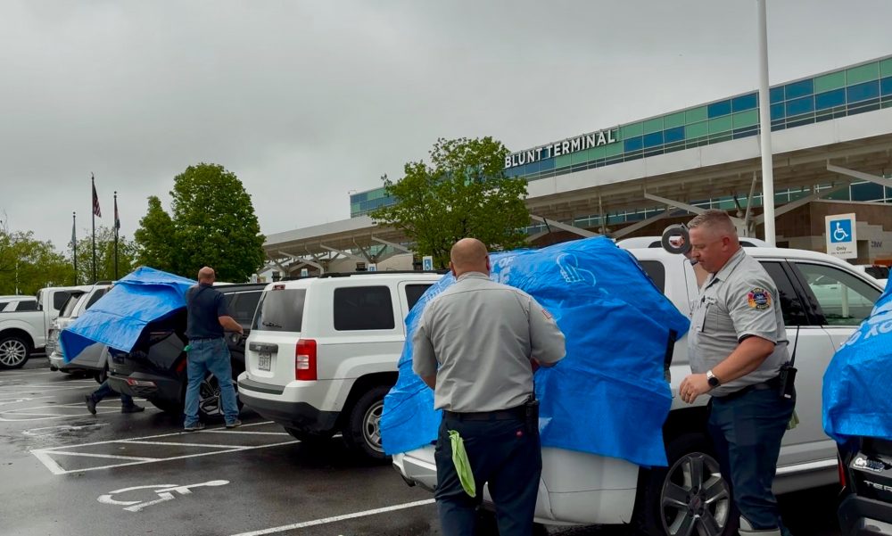
The Springfield-Branson National Airport, located approximately 5 miles northwest of downtown, experienced some of the most severe destruction.
Airport public information officer Ren Luebbering reported that dozens of flights faced delays or cancellations, while hundreds of parked vehicles suffered shattered windshields and sunroofs.
Because rental vehicles were also damaged, some travelers required bus transportation roughly 100 miles to Bentonville, Arkansas’s airport. Luebbering described how airport personnel worked for three hours to cover the most severely damaged cars with donated tarps.
“Our team distributed approximately 300 to 400 tarps across the parking areas,” Luebbering stated. The airport posted online advisories warning visitors to “Expect damage to your vehicle.”
Nicolette Zangara from the Springfield-Greene County Office of Emergency Management said she anticipated trouble from the beginning.
“The radar imagery clearly showed the hail was increasing in size,” Zangara explained. “When we began receiving photographs from surrounding counties showing their hail damage, we immediately recognized this would be a devastating storm.”
She confirmed that several individuals contacted 911 reporting injuries from hail shattering their windshields, though specific injury counts weren’t available. Vehicle damage appears to represent the most widespread destruction, with Zangara describing her own car as so heavily dented it resembles “the surface of a golf ball.”
“Late April seems particularly unlucky for our region,” she observed, referencing severe spring storms that struck the area exactly one year earlier.
Since the storm passed, Gockel has been busy filing multiple insurance claims. The hail completely destroyed his home’s gutters, and contractors are scheduled to assess his roof damage.
As a pizza business owner, Gockel reported damage to his food truck, work vehicles, and his teenage daughter’s first car, which he had purchased for her just one month ago.
Despite being accustomed to severe weather alerts, Gockel typically responds by watching storms from his front porch rather than seeking shelter.
“Usually nothing dramatic actually happens,” he reflected. “This marks the first time I’ve experienced a storm that truly matched the severity of the advance warnings.”