Weather officials from the National Weather Service Mount Holly office have issued a coastal flood advisory affecting Delaware’s coastal areas early Friday morning.
The advisory went into effect at 1:57 AM on April 19th and is scheduled to expire at 3:00 AM the same day, lasting just over one hour.
Residents and visitors along Delaware’s coast should remain aware of potential minor flooding conditions during the advisory period. The brief timeframe suggests conditions are expected to improve quickly as the morning progresses.
The National Weather Service Mount Holly office monitors weather conditions for Delaware and surrounding areas, issuing advisories when conditions warrant public awareness for safety purposes.
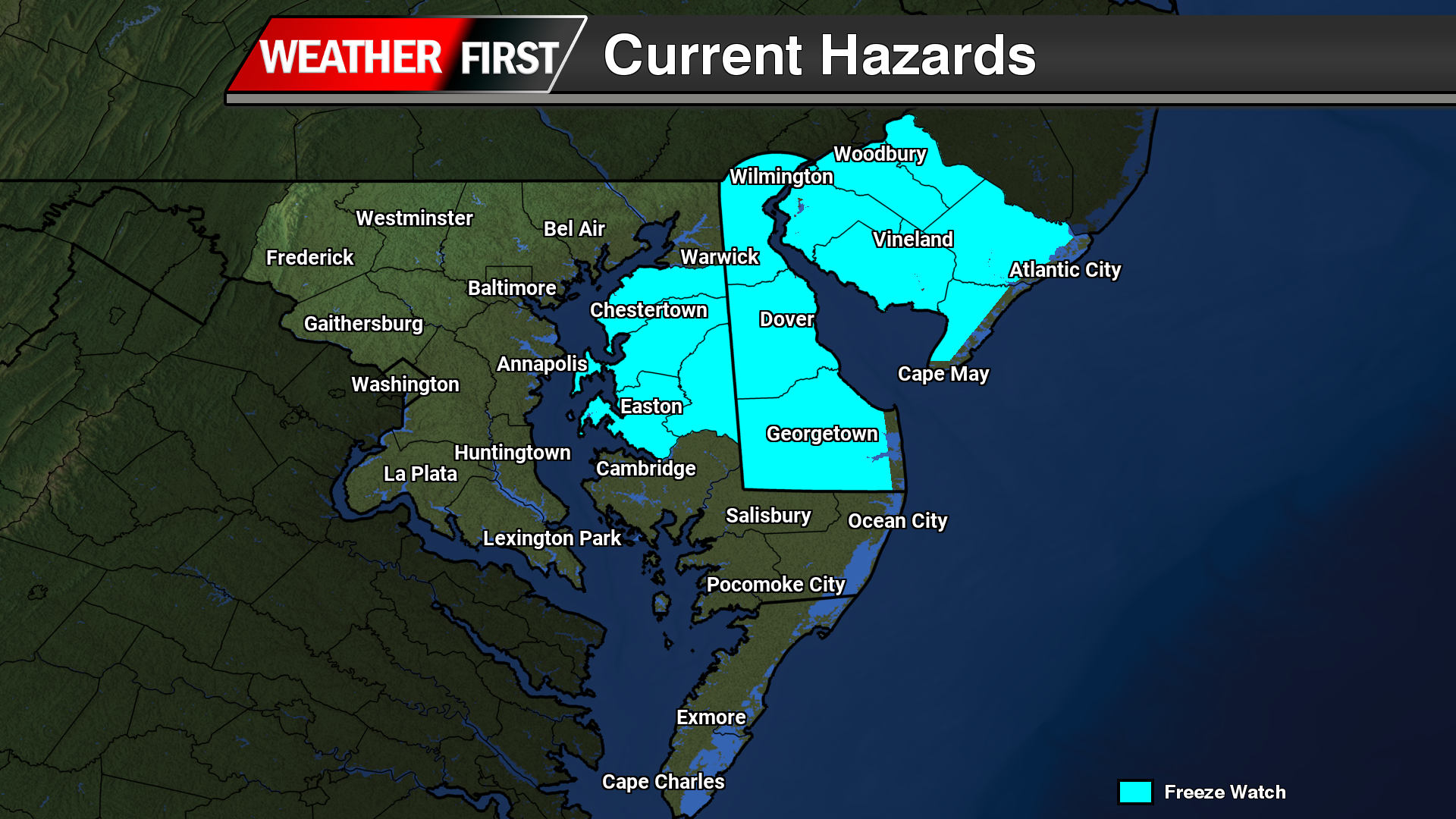
The National Weather Service office in Mount Holly, New Jersey has issued a freeze watch beginning Friday, April 19th at 1:11 AM and remaining in effect until Sunday, April 21st at 9:00 AM.
Weather forecasters are warning residents to prepare for potentially damaging cold temperatures that could affect outdoor plants, gardens, and agricultural crops during this extended period.
The freeze watch indicates that conditions are favorable for temperatures to drop to 32 degrees or below, which could cause significant harm to temperature-sensitive vegetation and plants that have already begun their spring growth.
Residents are advised to take precautionary measures to protect tender plants, outdoor plumbing, and other items that could be damaged by freezing conditions during this late-season cold snap.
Weather forecasters have issued a freeze watch for the area, warning residents to prepare for potentially damaging cold temperatures over the weekend.
The National Weather Service office in Mount Holly, New Jersey issued the freeze watch on April 19th at 1:11 AM EDT, with the alert remaining in effect until Sunday, April 21st at 9:00 AM EDT.
The timing of this cold weather advisory comes during a period when many plants and crops are vulnerable to frost damage as spring growing season gets underway.
Residents should take precautions to protect sensitive plants, outdoor plumbing, and pets during this period of below-freezing conditions.
Recovery operations have commenced in Wellington, New Zealand’s capital city, following devastating flash floods that struck the North Island over the weekend, according to local officials.
The Hutt City Council, which oversees part of the greater Wellington metropolitan area home to more than 520,000 residents, reported widespread damage throughout the region. “Severe weather has caused flood damage across the city,” the council stated in their official announcement.
Emergency response teams are currently deployed across Lower Hutt, where residents are grappling with significant flooding damage and scattered debris. The council confirmed that cleanup crews are prioritizing the most severely affected neighborhoods, particularly in Stokes Valley where conditions remain challenging.
“We know many people across Lower Hutt are dealing with flooding impacts and debris,” officials noted while describing ongoing recovery efforts in what they termed the “hardest hit areas.”
The flooding emergency extended beyond Wellington, with the Whanganui District, located approximately 95 miles to the north, declaring an official state of emergency. Radio New Zealand reported that 18 residents required evacuation due to dangerous flood conditions in that area.
Weather officials are cautioning residents to prepare for additional severe conditions, with forecasters predicting more intense thunderstorms and extremely heavy rainfall targeting portions of the North Island, including Wellington, throughout Sunday.
“These severe thunderstorms are moving towards the southeast,” meteorologists warned in their latest advisory.
The destructive weather pattern, which prompted Saturday’s evacuations, represents the second major weather event to impact the island within a week. Just seven days earlier, Cyclone Vaianu battered the same region, forcing numerous residents to seek safety on higher ground.
Dense fog is creating hazardous driving conditions across multiple areas of Sussex County, prompting Delaware Department of Transportation officials to issue a safety advisory for motorists.
The foggy conditions are significantly reducing visibility throughout various locations in the county, making travel more dangerous for drivers on local roadways.
DelDOT is urging all drivers to exercise extra caution while navigating through the fog-affected areas. Officials recommend reducing speed and ensuring headlights are turned on to improve visibility for both the driver and other vehicles on the road.
The fog advisory remains in effect as conditions continue to impact travel throughout Sussex County. Motorists are encouraged to allow extra time for their commutes and maintain safe following distances while the weather conditions persist.
Delaware’s coastal communities are under a flood advisory issued by the National Weather Service’s Mount Holly, New Jersey office on Thursday afternoon.
The coastal flooding alert went into effect at 4:00 PM on April 18th and will remain active until 2:00 AM on April 19th.
Residents and visitors along Delaware’s coastline should prepare for potential flooding in low-lying areas during this timeframe. The advisory serves as a precautionary measure for areas prone to tidal flooding.
Weather officials recommend avoiding flooded roadways and staying informed about changing conditions throughout the advisory period.
Weather officials have issued a coastal flood advisory for Delaware’s coastal regions, warning residents of potential flooding conditions along the shore.
The National Weather Service office in Mount Holly, New Jersey announced the advisory Thursday afternoon at 4:00 PM, with the alert remaining active until 2:00 AM Friday morning.
Coastal communities should prepare for possible minor to moderate flooding during high tide cycles while the advisory remains in effect.
Residents in affected areas are advised to monitor local conditions and avoid driving through flooded roadways during the advisory period.
Rural communities across the Upper Midwest began cleanup efforts Saturday following a devastating weather outbreak that brought confirmed tornadoes and destructive winds to the region.
The storms caused extensive property damage throughout multiple states — homes lost their roofs, electrical lines came down, and roadways became blocked by fallen debris. Remarkably, authorities confirmed zero fatalities from the severe weather event.
“We are extremely fortunate that this storm did not result in loss of life or serious injury,” Stephenson County Sheriff Steve Stovall said of the storm that hit Lena, Illinois, on Friday.
Authorities in Wisconsin and Minnesota shared similar relief about the lack of casualties.
Central Wisconsin communities of Kronenwetter and Ringle bore the brunt of tornado damage Friday afternoon, with homes sustaining major damage and some residents becoming temporarily stuck in their basements, according to Ringle Fire Chief Chris Kielman.
Marathon County Sheriff Chad Billeb expressed shock at the scope of destruction during a Friday evening press briefing, noting he had never witnessed such widespread damage in his three decades of police work.
“A lot of people are going to need a lot of help,” Billeb said of the Wisconsin storms.
Wisconsin State Representative Brent Jacobson warned Saturday morning via social media that the recovery effort would be lengthy.
“As the photos and videos continue to come in, it is clear that parts of Ringle and Kronenwetter suffered devastating damage,” Jacobson’s statement said.
Olmsted County, Minnesota experienced what sheriff’s deputies described as “multiple levels” of tornado damage. Marion Township alone saw at least 30 homes damaged, with several experiencing “significant” destruction.
Teams from Minnesota Homeland Security and Emergency Management, Rochester Fire and Olmsted County Sheriff’s Office conducted house-to-house wellness checks on residents, according to the sheriff’s office.
The National Weather Service confirmed the destruction appeared consistent with tornado damage and announced plans for damage assessment teams to survey the affected regions throughout the weekend.
In Illinois, 14-year-old Leo Zach had just arrived at his high school’s band room for a music competition when the structure began trembling and electricity failed. He described the room as crowded with students, some of whom experienced panic attacks from fear.
“I’m definitely on the luckier side of how that could’ve happened,” he said. “I was just trying to stay calm, help other people.”
Upon exiting the building, they discovered gymnasium windows had been blown out and sections of the school’s roof had been torn away.
Social media images and videos revealed completely destroyed garages, brick facades stripped from buildings, and demolished fencing.
Lena is a community of approximately 3,000 residents situated roughly 117 miles northwest of Chicago.
Rachel Nemon was traveling to collect her stepson from Lena’s middle school when she sought shelter at a car wash during the storm’s peak. She witnessed a massive tree being uprooted and electrical sparks flying just feet from her location.
“This is something that you see online, not in real life, especially in a small town in Illinois,” she said.
Governor JB Pritzker announced via social media platform X that he had received damage briefings and confirmed the Illinois Emergency Management Agency had deployed to the affected areas.
Weather experts are sounding the alarm as dry conditions across the continental United States have reached unprecedented severity for this time of year, creating concerns about wildfire dangers, agricultural losses, and rising grocery costs.
According to the U.S. Drought Monitor, over 61% of the Lower 48 states are currently experiencing moderate to severe drought conditions, with 97% of the Southeast and two-thirds of western states affected. These figures represent the most extensive drought coverage recorded for March since monitoring began in 2000.
The National Oceanic and Atmospheric Administration’s Palmer Drought Severity Index registered its most severe March reading since data collection started in 1895. Last month also ranked as the third-driest on record for any month, surpassed only by the notorious Dust Bowl periods of July and August 1934.
Unusually high temperatures have resulted in dramatically reduced snowpack levels across western regions during the early months of 2024, eliminating the area’s primary water storage system for summer months. Meanwhile, a separate drought pattern linked to jet stream changes has pushed storm systems northward, creating dry conditions stretching from Texas to the Atlantic Coast, according to Brian Fuchs, a climatologist with the National Drought Mitigation Center.
NOAA scientists estimate that eastern Texas would require 19 inches of rainfall within a single month to end current drought conditions, while most southeastern areas would need more than 12 inches to address their water deficits.
“Right now 61% of the country is in drought and that’s steadily been going up for the calendar year,” Fuchs said. “We just haven’t seen too many springs where this amount of the country has been in this kind of shape.”
UCLA hydroclimatologist Park Williams highlighted a concerning measurement called vapor pressure deficit, which tracks how aggressively hot, dry air extracts moisture from soil and vegetation. This “sponginess” factor currently sits 77% above normal levels and exceeds the previous January-March record by more than 25%.
Such intense ground moisture extraction “wouldn’t have appeared possible” previously, Williams noted.
The timing particularly worries meteorologists, since drought conditions typically worsen during summer rather than spring months.
“Fire tends to respond to heat and drought in an exponential manner,” Williams explained. “For each degree of warming, you get a bigger bang in terms of fire than you got from the previous degree of warming.”
In Arizona, desert cacti are flowering months ahead of schedule, and water concerns have already intensified, reported Kathy Jacobs, who directs the Center for Climate Adaptation Science and Solutions at the University of Arizona.
“Those of us who are dependent on the Colorado River, of course, are very concerned about the fact that we don’t have a negotiated path forward in the middle of what appears to be possibly the worst year of drought that we’ve all experienced,” Jacobs said. “We have lots of reservoirs that are not full.”
Yale Climate Connections meteorologist Jeff Masters expressed particular worry about agricultural impacts and subsequent food price increases. Poor American crop yields due to drought could create global food security issues, especially with predictions of a strong El Nino weather pattern that typically reduces harvests in other regions like India.
Williams from UCLA attributed the drought and elevated temperatures to a combination of natural weather variations and human-driven climate change, with natural factors playing a slightly larger role currently.
“All weather is now affected by climate change,” Jacobs emphasized. “There is no such thing as weather that’s divorced from climate trends. But this extreme event is extreme in the way that we’ve been expecting: extreme heat waves, intense drought.”
Dense fog is creating hazardous driving conditions across Delaware, prompting state transportation officials to issue a safety warning for motorists.
The Delaware Department of Transportation reports that foggy conditions with varying levels of thickness are impacting visibility throughout the First State. Officials are encouraging drivers to reduce speeds, increase following distances, and use low-beam headlights when navigating through the affected areas.
Motorists should allow extra travel time and consider postponing non-essential trips until conditions improve. The fog is expected to create particularly challenging conditions during morning and evening commute hours.
Weather officials have issued a coastal flood advisory for Delaware’s coastal areas, warning residents of potential minor flooding conditions along the shoreline.
The National Weather Service office in Mount Holly, New Jersey announced the advisory Thursday morning at 2:59 AM, with the alert scheduled to remain active until 3:00 AM on Friday.
The advisory covers coastal zones where minor flooding may occur during the warning period. Residents in low-lying areas near the coast should monitor conditions and take appropriate precautions.
Local authorities recommend staying informed about changing conditions and avoiding driving through any flooded roadways that may develop during the advisory period.
Delaware coastal communities are under a flood advisory issued by the National Weather Service office in Mount Holly, New Jersey.
The weather alert went into effect at 2:59 AM on Thursday, April 18th, and will remain active until 2:00 AM on Friday, April 19th.
Residents and visitors in coastal Delaware areas should prepare for potential flooding conditions during high tide periods and monitor local conditions closely.
The National Weather Service routinely issues these advisories when weather patterns and tidal conditions combine to create elevated flood risks along the shoreline.
Weather officials have issued a coastal flood advisory for the Delmarva Peninsula, warning residents of potential flooding conditions along shoreline areas.
The National Weather Service office in Mount Holly, New Jersey announced the advisory Thursday at 1:37 AM, with the alert scheduled to remain active until 2:00 AM on Friday, April 19th.
Coastal communities should prepare for possible minor flooding during high tide cycles as weather conditions create elevated water levels along the coast.
Residents in low-lying areas near the water are advised to monitor conditions and take appropriate precautions during the advisory period.
Weather officials have issued a coastal flood advisory for Delaware’s coastal regions, warning residents of potential flooding conditions along the shore.
The National Weather Service office in Mount Holly, New Jersey announced the advisory Thursday at 1:37 AM, with the warning set to remain active until 3:00 AM on Friday, April 19th.
The advisory alerts coastal communities to prepare for possible minor to moderate flooding during high tide cycles. Residents in low-lying areas near the coast should monitor conditions closely and take necessary precautions.
Local emergency management officials encourage people in affected areas to stay informed about changing conditions and avoid driving through flooded roadways if water accumulates.
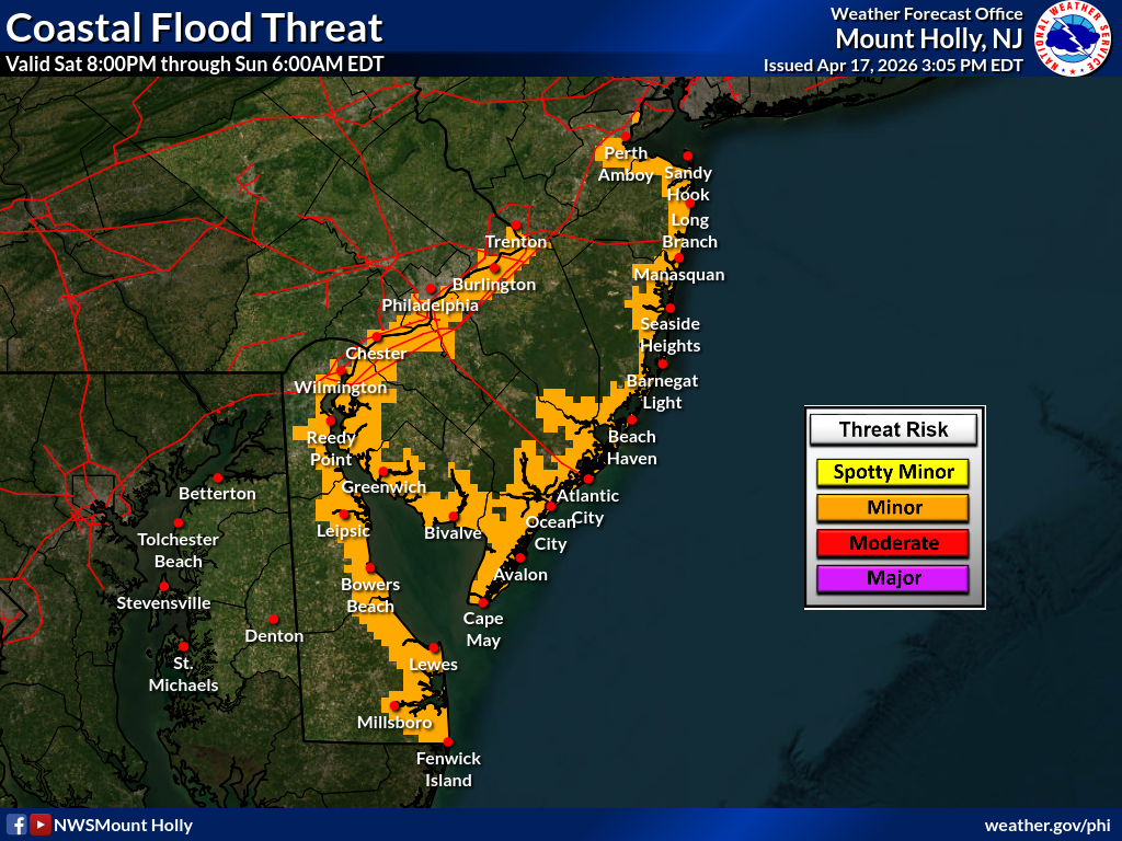
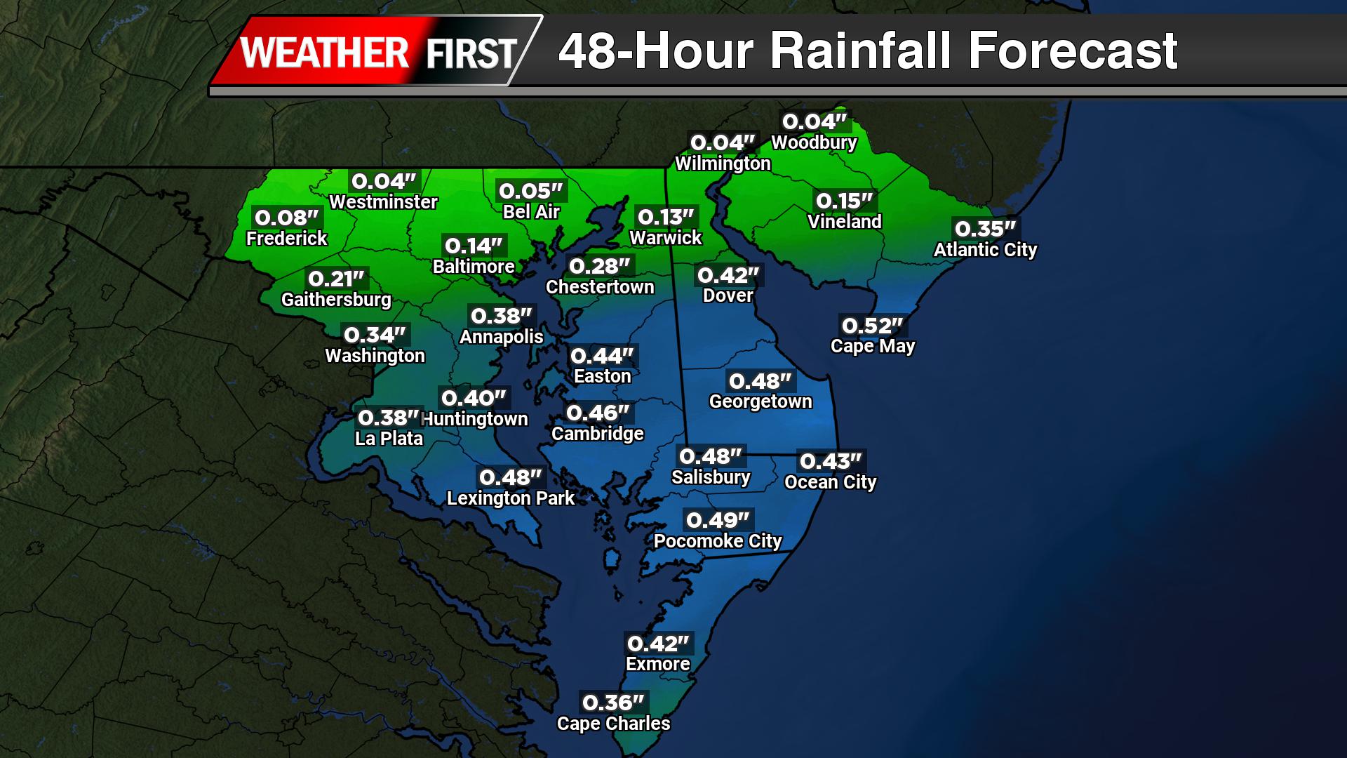
A period of minor coastal flooding is expected to impact parts of the Delmarva region this weekend, particularly along the Delaware coastline and Delaware Bay, as elevated water levels coincide with the upcoming high tide cycle.
A Coastal Flood Advisory has been issued for coastal Delaware, including areas along Delaware Bay, for Saturday evening into Saturday night. The primary concern centers around widespread minor tidal flooding, driven by a combination of astronomical and meteorological factors.
The timing of the new moon is playing a key role, producing higher-than-normal astronomical tides. At the same time, a developing onshore southeast flow will push additional water toward the coast. By Saturday evening, water levels are expected to rise to around one foot above normal, which is sufficient to bring many typically vulnerable locations into minor flood stage during high tide.
While some isolated minor flooding cannot be ruled out during the high tide cycle Friday night, impacts are expected to remain limited. The more notable and widespread concerns arrive with Saturday evening’s high tide, when the combination of elevated tides and persistent onshore winds peaks.
Residents in low-lying and flood-prone areas along the Delaware beaches and Delaware Bay should be prepared for minor roadway flooding, especially near the immediate coastline and tidal waterways. Poor drainage areas may also see water encroachment during the high tide window.
Conditions will begin to improve by Sunday, as a cold front moves through the region and winds shift offshore. This change in wind direction is expected to reduce water levels and limit any additional coastal flooding concerns by Sunday night.
It is worth noting that no tidal flooding is expected along the Chesapeake Bay side of the Eastern Shore, where water levels will remain below flood thresholds.
Those in vulnerable coastal areas are encouraged to monitor water levels and plan accordingly around the Saturday evening high tide cycle.
The National Weather Service office in Mount Holly, New Jersey has issued a coastal flooding alert that will remain active from Wednesday afternoon through the early morning hours of Friday.
The advisory went into effect at 3:00 PM on April 17th and is scheduled to continue until 2:00 AM on April 19th.
Residents in coastal communities should be prepared for potential flooding conditions during this timeframe and take appropriate precautions.
The National Weather Service office in Mount Holly, New Jersey has issued a coastal flood advisory that went into effect Wednesday afternoon at 3:00 PM and will remain active until 3:00 AM on Friday morning.
The advisory warns residents and visitors in coastal areas to prepare for potential flooding conditions during high tide cycles over the next day and a half.
Coastal flood advisories are typically issued when minor to moderate flooding is expected in low-lying areas near the shore, including roads, parking lots, and properties close to the waterline.
Residents in affected areas should avoid driving through flooded roadways and take necessary precautions to protect property that may be vulnerable to rising water levels.
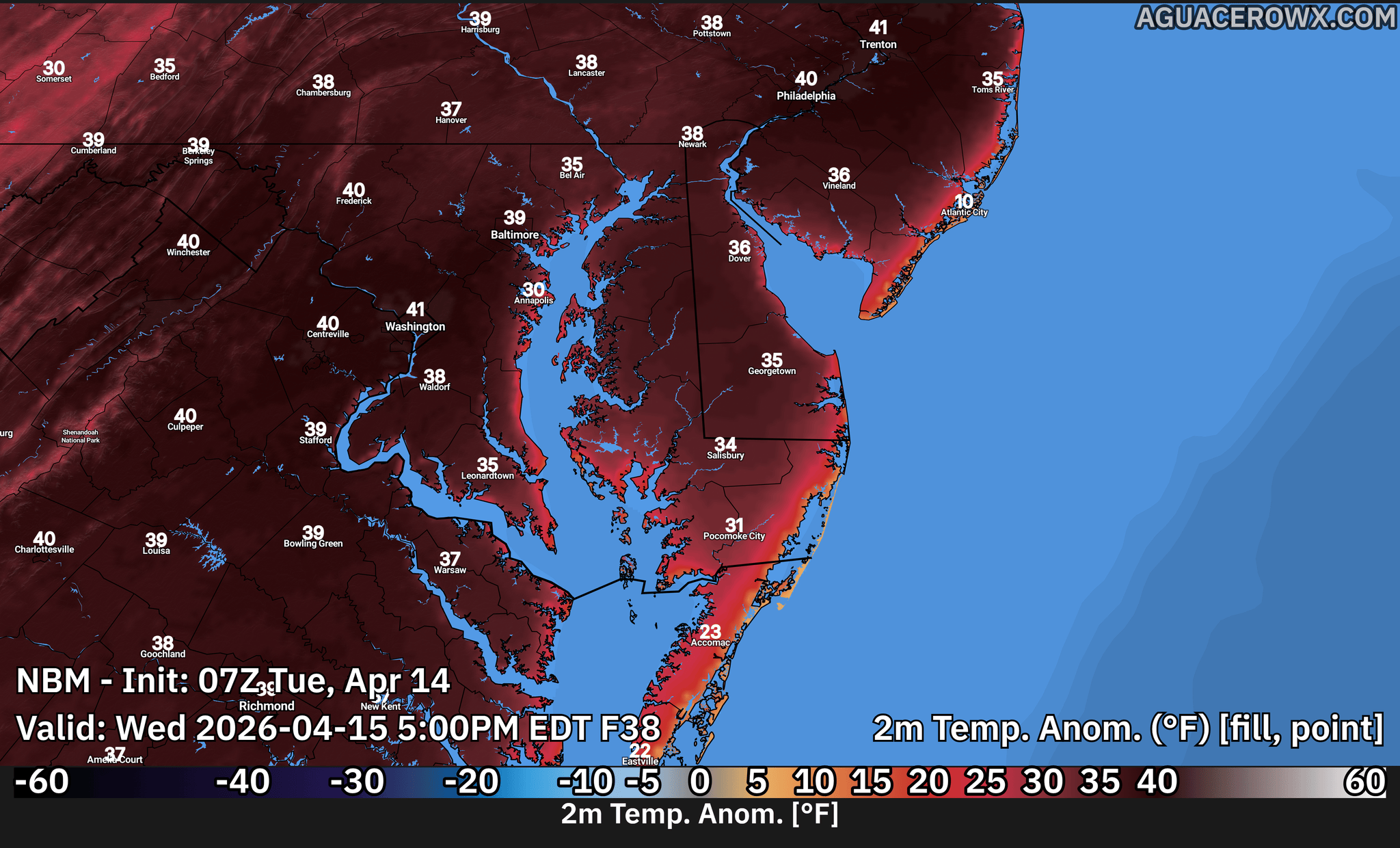
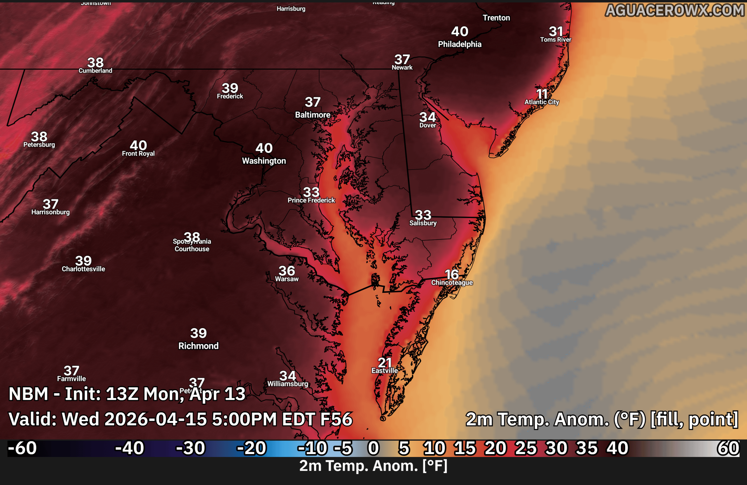
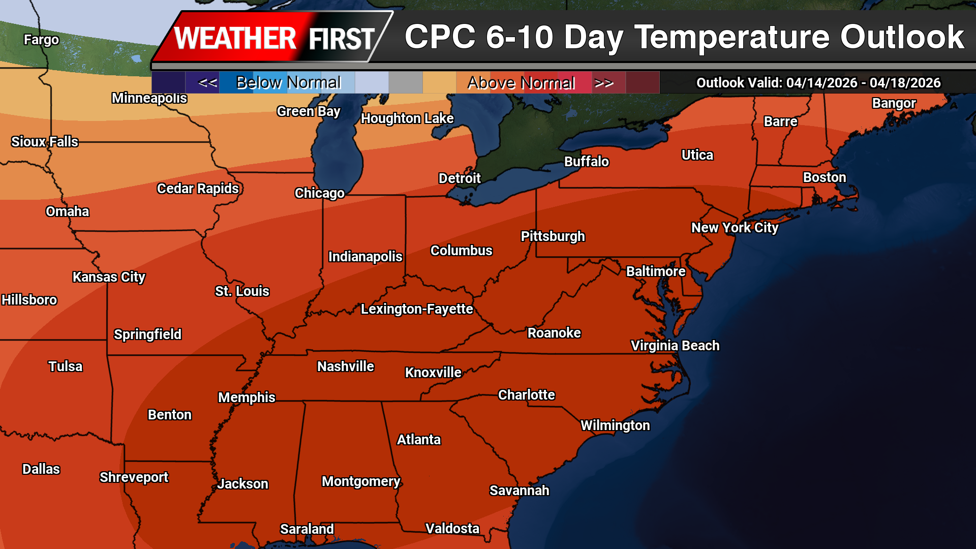
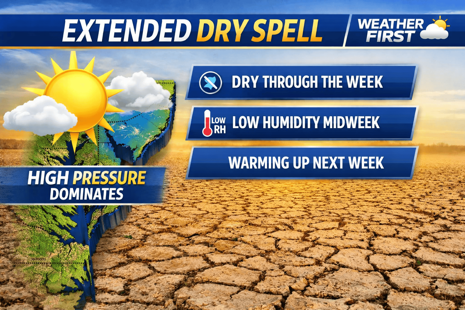
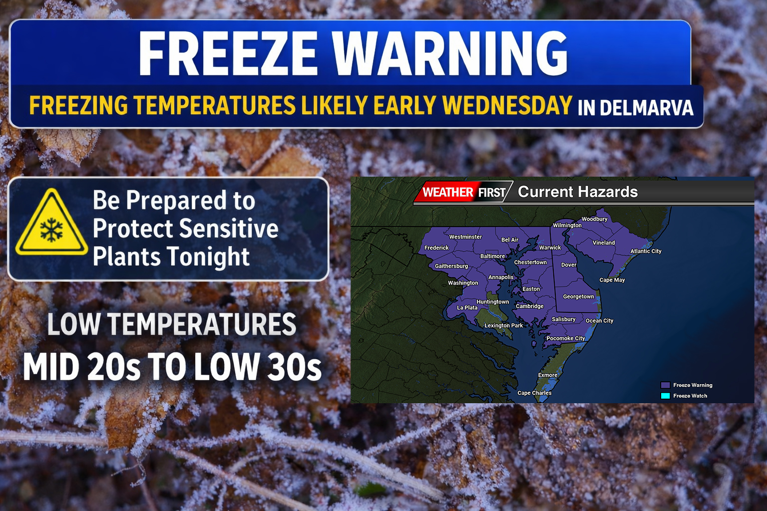
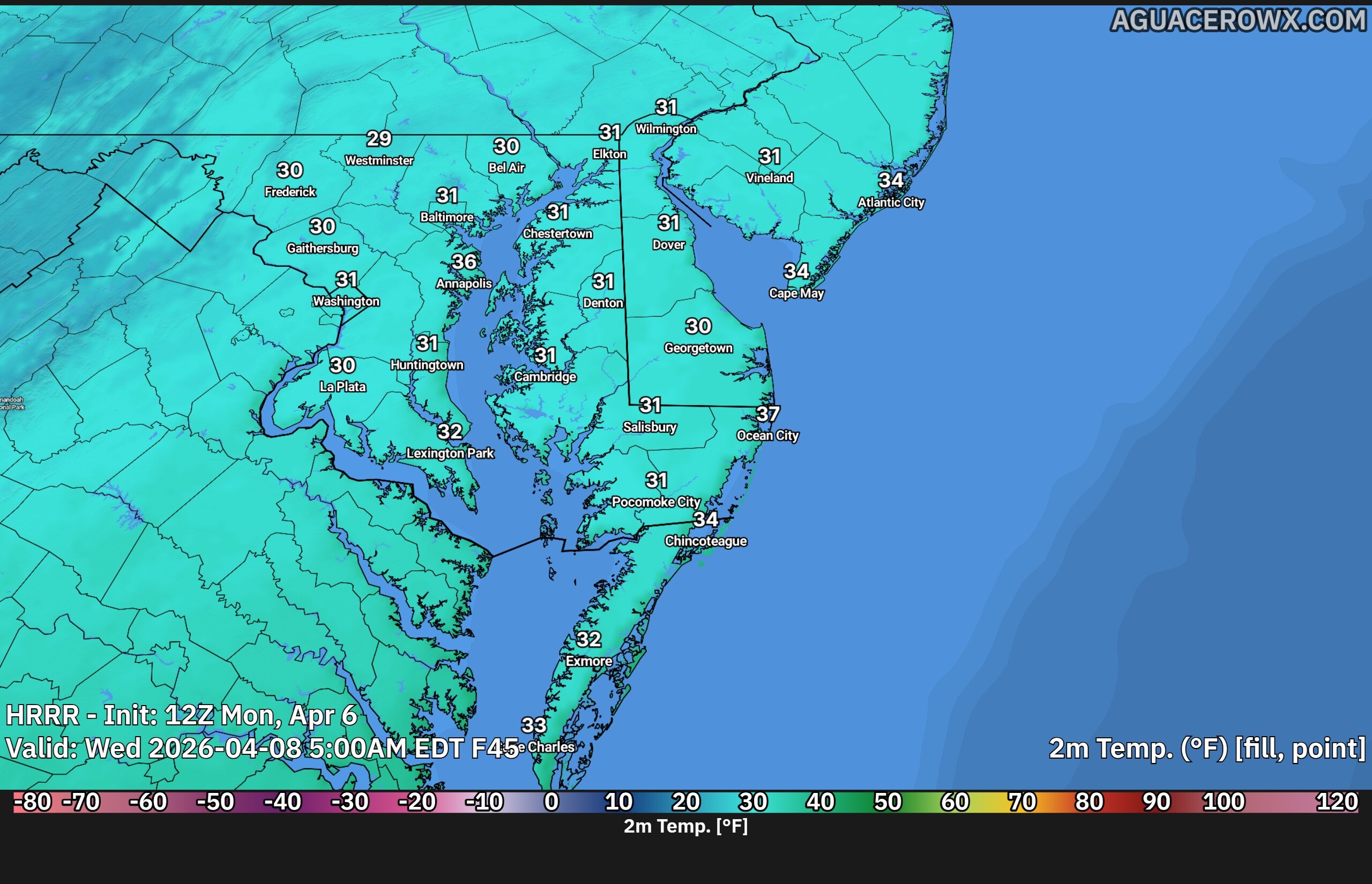
A sharp pattern change is set to impact the Delmarva region early this week, bringing a return to much cooler, below-normal temperatures along with the potential for widespread frost and freezing conditions.
Following the recent stretch of record warmth, a cold airmass will settle into the region Sunday night into Monday. While temperatures will drop into the 30s overnight, lingering northwest winds are expected to stay elevated enough to limit widespread frost formation initially. However, the bigger concern arrives Monday night into early Tuesday morning, when high pressure builds overhead, winds diminish, and optimal radiational cooling conditions develop.
By daybreak Tuesday, temperatures across Delmarva are expected to fall into the mid 30s, creating a strong likelihood for widespread frost and potentially damaging freeze conditions. This could pose a risk to sensitive vegetation and early-season crops, especially given that the growing season is now active across much of the region.
Monday itself will feel dramatically different compared to the recent warmth, with afternoon highs only reaching the mid 40s to mid 50s, roughly 10 to 15 degrees below average for mid-April. Gusty northwest winds up to 30 mph will add to the chill, making it feel even colder throughout the day.
Conditions begin to improve by Tuesday afternoon as temperatures rebound into the mid 50s to low 60s under gradually moderating conditions. By Tuesday night, lows are expected to remain in the 40s, effectively ending the frost and freeze threat.
Looking ahead, a warming trend will continue through the middle and latter part of the week, with temperatures returning to near or slightly above normal levels and limited chances for precipitation across the Delmarva region.
Delaware Department of Transportation officials have temporarily shut down Airport Road at the Nonesuch Creek crossing due to flooding conditions that have made the roadway impassable.
The closure affects the section of Airport Road that spans the creek, where rising water levels have created unsafe driving conditions for motorists.
DelDOT has not provided an estimated timeline for when the road will reopen, as conditions depend on water levels receding to safe levels.
Drivers in the area are advised to seek alternate routes and avoid the flooded section until further notice from transportation officials.
A dangerous weather system moving through America’s heartland claimed at least one life Thursday as severe conditions continue threatening communities with tornadoes, flooding, and deadly lightning strikes.
The fatality occurred Wednesday evening in Waukesha, located west of Milwaukee, where authorities say a man was apparently killed by lightning while walking through a parking lot during intense storms. According to local police, the “area was experiencing heavy rainfall accompanied by significant thunder and lightning” when someone spotted the victim on the ground.
“Preliminary information indicates the individual was struck by lightning while walking through the parking lot during the storm,” police said.
The widespread severe weather outbreak has been fueled by an atmospheric setup combining extremely humid conditions with a powerful jet stream, creating a dangerous corridor stretching from central Texas northward into the Midwest and eastward across the Great Lakes region. Between Monday and Wednesday alone, the National Weather Service documented more than 1,100 incidents of damaging weather including large hail, winds exceeding 60 mph, and tornado touchdowns, according to Bill Bunting, a meteorologist with the Storm Prediction Center.
These dangerous conditions have persisted across numerous states throughout the week and may extend into the weekend.
“There’s been a tremendous amount of lightning with these storms over the last few days,” said Mark Gehring, a meteorologist with the weather service in Milwaukee.
“We’ve had the temperature and humidity of summer and it’s lasting an entire week — in mid-April,” he added. “In addition to a very stormy pattern, nearly every day we’re having heavy rain. We’ve had tornadoes nearly every day, very large hail.”
Weather officials have confirmed five tornado touchdowns across southern and central portions of Wisconsin, though Gehring expects that number to grow as damage surveys continue. He warned that Friday evening could bring another round of severe weather to the region.
Beyond the tornado and lightning threats, the storm system has delivered torrential rainfall, prompting weather officials to issue numerous flood warnings and watches spanning multiple states.
Emergency crews in Cheboygan, Michigan worked frantically this week to pump water from a threatened dam, even removing floodgates to reduce pressure buildup. City officials warned residents and businesses Monday to prepare emergency bags with essential medications, documents, and supplies while staying alert for evacuation orders due to rising flood risks.
The small northern Michigan community of Bellaire, home to about 1,000 residents, announced Thursday that excessive rainfall has overwhelmed its sewage treatment facilities, forcing officials to discharge partially treated wastewater into nearby wetlands. Village leaders asked residents to minimize household water usage to help reduce the burden on the failing system.
Carl Johnson, 59, owns property along the rapidly swelling Muskegon River in western Michigan and has offered to help neighbors with his boats as waters continue rising.
“It’s out of the banks everywhere. It’s really bad,” he told The Associated Press. “It’s not supposed to crest until Saturday.”
In Portage, Wisconsin, the Wisconsin River has reached major flood stage and forecasters predict it could meet or exceed the record level of 20.7 feet sometime Friday morning, meteorologist Gehring reported.
“Right now, it’s at 19.9 feet, not that far off,” he said. “In Portage, there’s a large area of low-land flooding. Many roads are flooded. There’s a levee there. It’s important that the levee holds.”
Wisconsin Governor Tony Evers issued a state emergency declaration earlier this week as conditions worsened.
Motorists became stranded Wednesday night when floodwaters overtook a Milwaukee-area highway, prompting the Milwaukee County Sheriff’s Office to post urgent warnings advising residents to avoid driving in southeastern Wisconsin.
However, relief may be approaching for Wisconsin residents dealing with the relentless weather pattern.
“We have one more severe, heavy rain event coming this way before we get a good break,” Gehring said. “That’s going to be on Friday evening. That’s going to be the last gasp of severe rain.”
Friday’s weather system will still pose risks for additional tornadoes, heavy downpours, and flooding concerns.
“It just keeps coming, but that will be the last one,” Gehring said.
Federal weather experts and military personnel will bring their specialized hurricane-tracking aircraft to Gulf Coast communities next month to help residents prepare for the 2026 storm season, which begins June 1.
During National Hurricane Preparedness Week, NOAA and U.S. Air Force Reserve teams will showcase four aircraft used to monitor dangerous storms. Community members and media representatives can get an up-close look at the planes and speak with meteorologists, scientists, and flight crews who risk their lives flying into hurricanes to gather critical data.
This year’s tour features an exceptional display of aircraft: NOAA’s Lockheed WP-3D Orion, which is marking its 50th year of hurricane tracking service, along with the agency’s Gulfstream IV-SP and Beechcraft King Air 350 CER. The U.S. Air Force Reserve will display their WC-130J aircraft.
The tour will make three stops across the region:
– Monday, May 4: Sarasota Bradenton International Airport, 9 a.m. to 3 p.m. – Tuesday, May 5: Mobile International Airport, 9 a.m. to 3 p.m. – Wednesday, May 6: Lake Charles Chennault International Airport, 9 a.m. to 3 p.m.
Leading hurricane experts will participate in the events, including Michael Brennan, who directs NOAA’s National Hurricane Center, and Robbie Berg, a warning coordination meteorologist at the center. Storm surge specialist Cody Fritz and Weather Prediction Center meteorologist Owen Shieh will also attend, along with flight crews from both agencies.
Media representatives seeking interviews with NOAA specialists can contact Public Affairs Officer Maria Torres at [email protected] or 305-433-1933. For Air Force Reserve interviews, contact Lt. Col. Marnee Losurdo at [email protected] or 228-377-2056.
The events aim to educate coastal residents about hurricane dangers and preparation strategies before the active season begins.
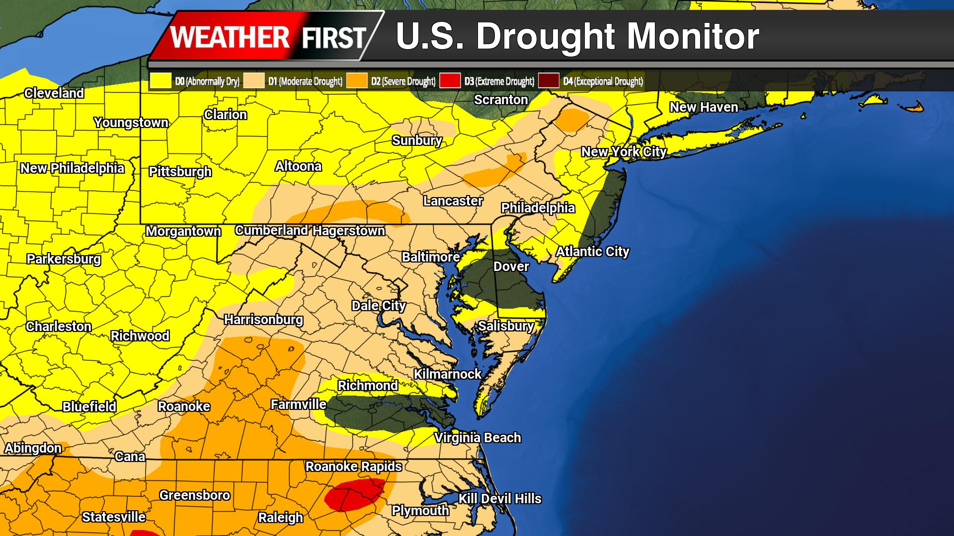
The latest update from the U.S. Drought Monitor shows a worsening drought situation across the Mid-Atlantic, with a significant portion of Maryland’s Western Shore now classified under severe drought (D2), while Delmarva continues to experience abnormally dry to moderate drought conditions. Areas along the Chesapeake Bay, including Anne Arundel, Calvert, and St. Mary’s Counties, are seeing increasing impacts from prolonged dryness, with soil moisture deficits becoming more pronounced and early signs of stress emerging in local waterways and vegetation.
This deterioration is being driven by a persistent pattern of above-normal temperatures and limited rainfall. High pressure anchored over the western Atlantic has allowed temperatures to surge well into the 80s and even low 90s at times, running 15 to 30 degrees above average. At the same time, rainfall has been inconsistent and largely insufficient to offset ongoing moisture loss. The combination of warm temperatures, lower afternoon humidity, and breezy conditions has accelerated the drying of both soils and fine fuels across the region.
The designation of D2 severe drought signals more significant impacts are beginning to take hold, particularly across the Western Shore. Agricultural interests are facing increasing concerns as soil moisture continues to decline during the early stages of the growing season, while some streams and smaller waterways may begin to show reduced flow levels if the pattern persists. Fire weather is also becoming a growing concern, as dry grasses and leaf litter become more susceptible to ignition, increasing the risk for rapidly spreading wildfires on warm, breezy days.
Across Delmarva, conditions are not yet as severe, but the trend is heading in that direction. Much of the region remains in D0 (abnormally dry) status, with pockets of D1 (moderate drought) beginning to develop. Without a shift toward more consistent rainfall, further degradation is possible in the coming weeks, especially given the continued stretch of warm weather in the forecast.
Looking ahead, there is little indication of widespread, soaking rainfall in the near term that would significantly improve conditions. While a few systems may bring scattered showers, they are unlikely to provide meaningful drought relief. Longer-range outlooks suggest precipitation chances may increase later in the spring, but continued above-normal temperatures could offset those gains. For now, drought conditions remain a growing concern across both Delmarva and Maryland’s Western Shore, with impacts expected to expand if the current pattern holds.
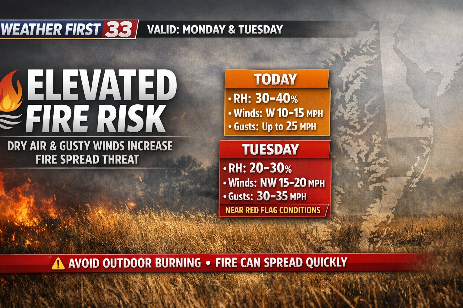
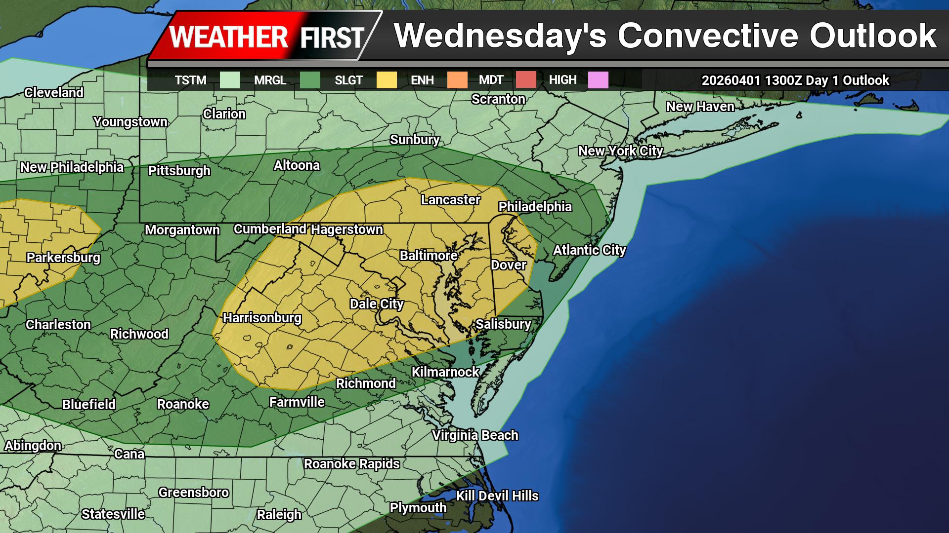
An elevated risk for fire spread is in place today across the Delmarva Peninsula as a combination of unseasonably warm temperatures, low humidity, and breezy conditions creates a favorable environment for rapidly spreading fires.
Forecasts indicate that afternoon relative humidity values will drop into the 25 to 35 percent range, which is notably dry for this time of year. At the same time, temperatures are expected to surge into the mid 80s to low 90s across much of Delaware, Maryland’s Eastern Shore, and parts of southern New Jersey. Southwesterly winds will also increase, sustained around 10 to 15 mph with gusts up to 20 mph.
This setup is particularly concerning given the continued drying of fine fuels such as grass, leaves, and small vegetation. These fuels can ignite easily and allow fires to spread quickly, especially when aided by gusty winds. Once a fire starts under these conditions, it can become difficult to control in a short amount of time.
The elevated risk is expected to peak during the afternoon hours, when temperatures are highest and humidity is at its lowest. Conditions will gradually improve this evening as winds diminish and moisture levels begin to recover.
Officials strongly discourage any outdoor burning today across the region. Residents are urged to properly dispose of potential ignition sources, including cigarette butts, and to use extreme caution when operating outdoor equipment such as lawn mowers or machinery that could generate sparks.
This fire weather risk assessment takes into account not only the atmospheric conditions, but also the current state of vegetation and ground fuels. The forecast has been coordinated with state fire officials to ensure accuracy and preparedness across the region.
Residents across Delmarva are encouraged to remain vigilant and take preventative measures to reduce the risk of fire ignition and spread through the remainder of the day.
ANN ARBOR, Mich. — Violent weather systems swept across Michigan early Wednesday, causing extensive damage including torn roofing at ice facilities, street flooding, and toppled trees in areas surrounding the University of Michigan’s central campus.
Teams from the National Weather Service conducted damage assessments throughout affected regions, including Ann Arbor, to verify whether tornadoes had made ground contact, though none were confirmed by Wednesday morning. The destruction stemmed from a severe thunderstorm front that traveled into Michigan from Iowa, Wisconsin and Illinois, according to meteorologist Sara Schultz.
Wind speeds reached 70 mph at the university’s football stadium during the early morning hours Wednesday, while Willow Run Airport and Detroit Metropolitan Airport recorded gusts of 69 mph and 62 mph respectively, Schultz reported. Additional powerful storm systems carrying potentially destructive winds were approaching the region from western states.
Widespread flooding affected roadways throughout southeastern Michigan communities Wednesday.
Multiple Ann Arbor public school facilities sustained structural harm and lost electrical service. District officials canceled classes Wednesday due to fiber network failures that disabled fire safety, telephone and security camera systems, along with building entry controls.
Ann Arbor Mayor Christopher Taylor reported that structural engineers were evaluating wall damage at the city’s Veterans Memorial Park Ice Arena. The university’s Yost Ice Arena also lost portions of its roofing.
The severe weather toppled a massive tree outside Seungjun Lee’s Ann Arbor residence, coming within feet of his second-story bedroom.
“If the tree fell down a couple more feet, I would not be standing here,” said Lee, a 20-year-old junior at U-M.
Lee and his housemates were roused by emergency sirens, followed by phone alerts between 1 a.m. and 2 a.m. instructing them to seek immediate shelter.
“As soon as I came out, everyone else was coming out of their rooms and everyone’s like, ‘What’s going on? This is crazy,’” said Lee, of Ridgewood, New Jersey. “And then we looked out the window: This tree just fell down.”
His roommate, Gautam Nigam, 21, said he couldn’t miss class despite the chaos: “I have a final presentation later today.”
Rainfall totals reached 2.5 inches across southeastern Michigan by Wednesday morning, with additional precipitation forecast for the Midwest, Great Lakes and Ohio Valley areas. Flood advisories were issued for extensive portions of Michigan’s eastern Lower Peninsula, southeastern Michigan, northern Indiana, northwestern Ohio, the Chicago metropolitan area and Wisconsin.
Wisconsin Governor Tony Evers issued an emergency declaration Wednesday following at least three confirmed tornadoes in the state this week, with additional severe weather anticipated.
Madison, Wisconsin’s capital, experienced hail ranging from golf ball to baseball size Tuesday afternoon.
In northern Michigan, electrical outages during the storm resulted in the death of 1,750 steelhead trout at a state hatchery facility where reproductive materials are harvested for fish production. Scott Heintzelman from the state’s fisheries division called it a “devastating event” involving “big, beautiful fish.”
The fish naturally migrate into a collection structure on the Little Manistee River before moving to holding ponds. Heintzelman said staff discovered Tuesday that power loss had halted oxygenated water circulation, causing the fish deaths.
Wisconsin’s Department of Natural Resources announced monitoring of levees surrounding Portage, a community of approximately 10,000 residents, as the Wisconsin River continues rising. By Wednesday morning, the river had reached nearly 19 feet at that location, approximately 2 feet above flood level, with potential increases to about 20 feet.
Following multiple days of rainfall and winter snowmelt, a “significant influx of water” is entering Black Lake in northern Michigan, according to the sheriff’s office.
The lake drains into the Black River and supplies the Cheboygan River, which flows through the city into Lake Huron. Officials have been controlling water flow through the city’s Cheboygan Dam by adjusting gates, installing pumps, raising a bridge and restricting public access to some waterfront areas.
Flooding and hazardous travel conditions prompted Cheboygan Area Schools to suspend classes and athletic activities for Thursday and Friday.
“Conditions are not improving significantly and, in some areas, continue to worsen,” the district stated.
Bill Bunting, a meteorologist with the weather service’s Storm Prediction Center, characterized a “very dynamic weather pattern” combining extremely humid air with powerful jet stream activity across the central United States and Great Lakes, creating ideal conditions for severe thunderstorms.
By early Wednesday afternoon, the weather service had documented over 400 reports of hail, winds exceeding 60 mph or tornadoes, he noted.
The weather system extended northward Wednesday evening from central Texas through Iowa and southern Wisconsin, then eastward across portions of Michigan, Illinois, northern Indiana and Ohio toward upper Pennsylvania and the Buffalo, New York region, Bunting explained.
In eastern areas, temperatures are expected to soar to extreme levels, potentially breaking record highs in New York, Philadelphia and Washington, D.C. through the weekend, forecasters predict.
A devastating super typhoon wreaked havoc across US Pacific territories, overturning vehicles and destroying rooftops while leaving thousands without electricity. Remarkably, officials report no fatalities despite the storm’s tremendous destructive power.
Emergency officials have begun evaluating the extensive destruction caused by Super Typhoon Sinlaku, which struck the Northern Mariana Islands on Tuesday evening local time and continued battering the region with powerful winds and heavy rainfall throughout Wednesday.
Electrical service remained down and numerous roadways became blocked throughout Saipan, the largest island in the Mariana chain and a US territory housing approximately 43,000 residents, local authorities confirmed.
Guam, home to multiple American military installations and another US territory, also experienced significant impact from the storm’s tropical-force winds.
According to the National Weather Service, this typhoon represents 2024’s most powerful tropical cyclone globally, bringing sustained winds reaching 150 mph when it struck the islands.
As the massive storm moved northward away from Saipan, Tinian and Rota late Wednesday evening, it maintained winds of 125 mph, meteorologists reported. Forecasters predict Sinlaku will curve toward the sparsely inhabited volcanic islands in the northern Marianas region.
“It was still very windy and rainy roughly 24 hours after the typhoon rattled the islands, but much better than the previous night,” stated Jaden Sanchez, who speaks for the Saipan mayor’s office.
“Preliminary reports include a lot of flooding, uprooted trees and downed power lines, but no deaths,” Sanchez explained.
Photographs from Saipan revealed residential areas covered in wreckage and twisted trees. The fierce winds demolished metal stadium seating at an athletic facility.
Local resident Dong Min Lee captured footage showing one automobile stacked atop two others in his apartment complex parking area. The storm winds also damaged portions of his balcony guardrail.
Emergency shelter operations by the American Red Cross and partner organizations housed more than 1,000 people throughout Guam and the Northern Marianas, according to agency representative Stephanie Fox.
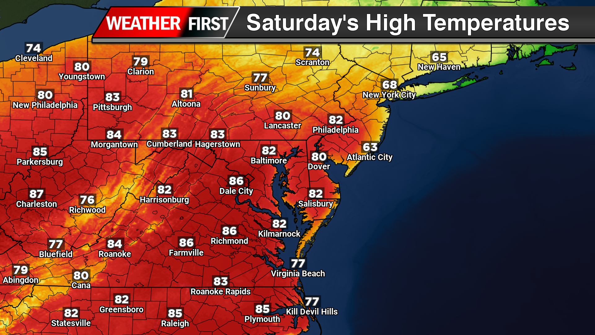
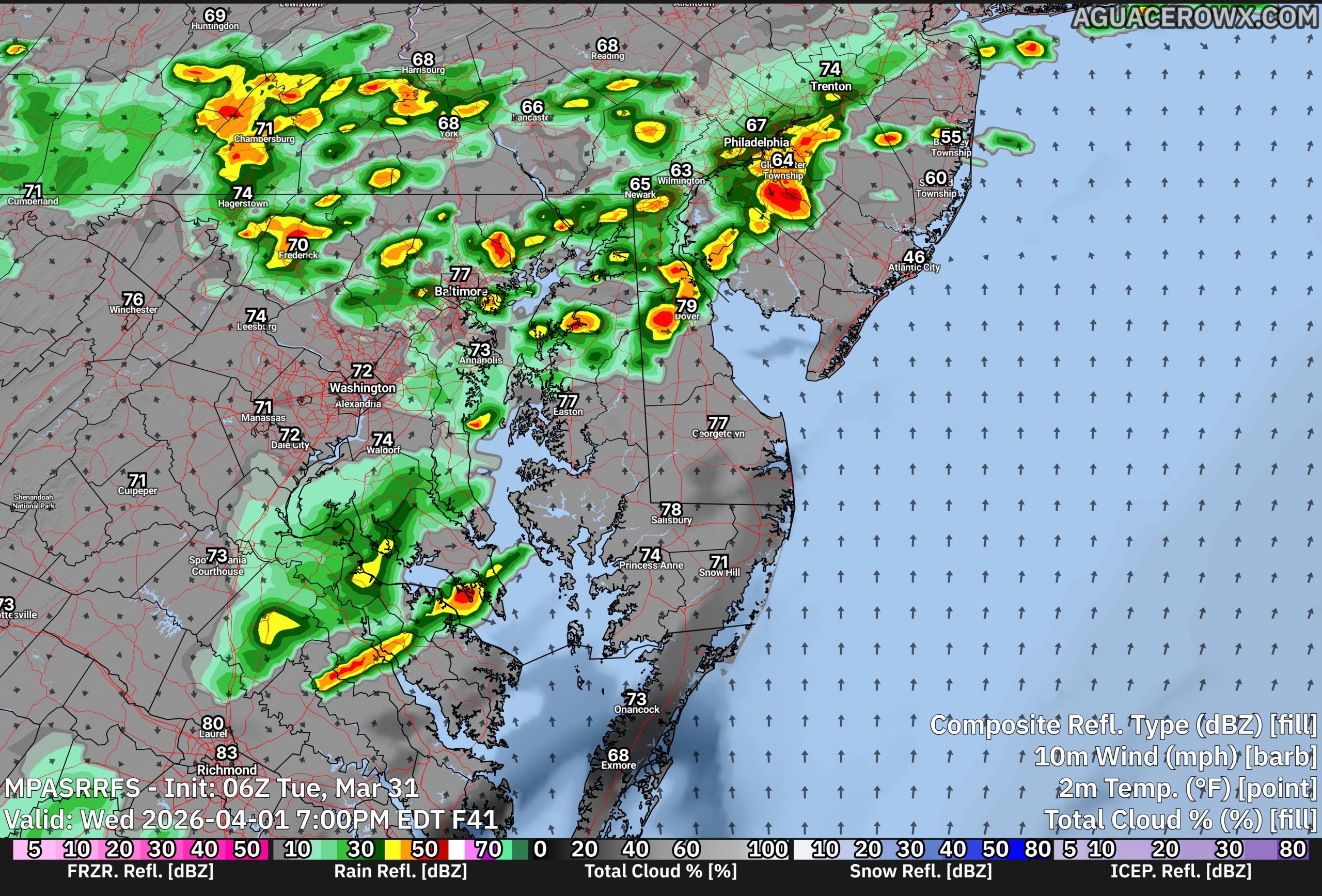
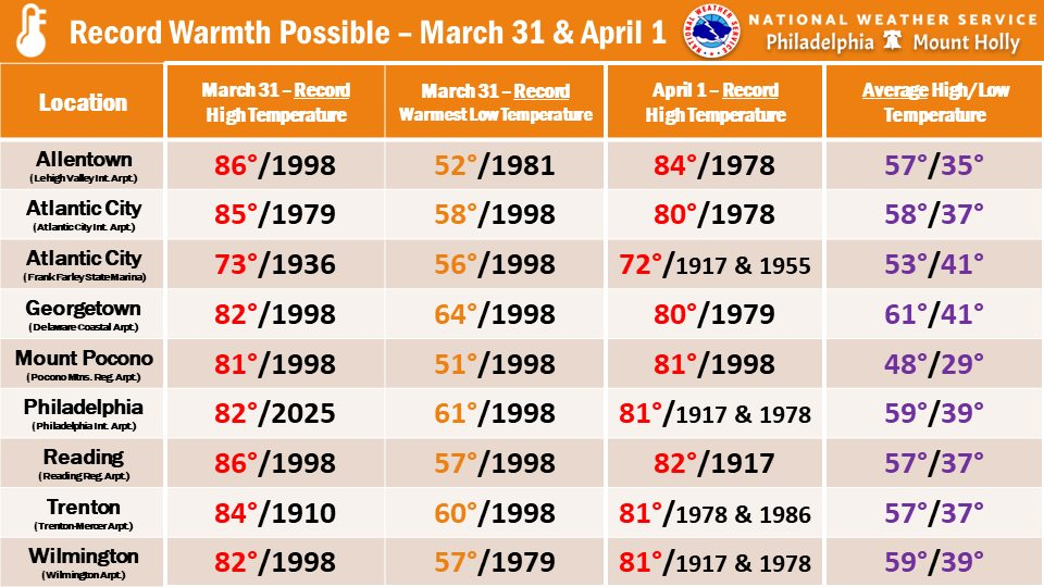
A surge of early-season heat is firmly in place across the Delmarva region, with record-breaking warmth expected to continue through the remainder of the week and into the upcoming weekend.
High pressure anchored over the Atlantic Ocean, combined with a warm front positioned well to the north, is allowing an unseasonably warm air mass to dominate the region. This setup is driving temperatures 20 to 40 degrees above average for mid-April, creating conditions more typical of early summer than spring.
For today and tomorrow, much of Delmarva is expected to see afternoon highs climb into the upper 80s to near 90 degrees. These will likely be the warmest days of the stretch, with several locations poised to challenge or break daily high temperature records, along with records for warm overnight lows. If temperatures reach 90 degrees, it would mark the first occurrence of the year for many areas and the first since early September.
Despite the widespread heat, coastal communities along the Atlantic will experience noticeably cooler conditions. This is due to colder sea surface temperatures and the development of a daytime sea breeze, which will keep areas near the beaches significantly lower than inland locations.
A weak surface front is expected to pass through early Friday morning, but it will do little to disrupt the overall warm pattern. Temperatures will remain well above normal through the weekend, generally ranging from the mid 70s to mid 80s. A more noticeable return to seasonable conditions is expected early next week.
In addition to the warmth, dry conditions will persist across much of Delmarva. While a few isolated showers are possible at times, particularly late this week and again on Friday, rainfall amounts are expected to remain minimal, generally only a few hundredths of an inch. A better opportunity for more meaningful rainfall, potentially exceeding a tenth of an inch, may arrive on Sunday.
This extended stretch of warm and mostly dry weather is raising concerns for ongoing drought and abnormally dry conditions across the region. Without significant rainfall, conditions are likely to worsen in the short term.
Despite the dry pattern, fire weather concerns remain relatively low for now. Winds are expected to stay light, and a persistent southwest flow should keep relative humidity values above critical thresholds, limiting the potential for rapid fire spread.
Devastating winds and torrential rainfall from Super Typhoon Sinlaku have unleashed destruction across isolated U.S. territories in the Pacific Ocean, tearing apart metal roofing and driving islanders into emergency shelters.
The massive storm system has been relentlessly hammering the remote islands with hurricane-force winds and heavy precipitation, causing significant structural damage as residents hunker down for safety.
A persistent weather system is preparing to unleash furnace-like conditions across the eastern United States, with an extraordinary April heat wave threatening to break temperature records Wednesday in major metropolitan areas like New York, Philadelphia, and Washington, D.C.
This early-season heat is remarkable not just for its intensity but for how long it’s expected to persist. Weather experts predict these near-record temperatures will continue through the weekend.
The dangerous conditions follow destructive storms that swept through Kansas, Minnesota, and Wisconsin Monday, with additional severe weather threatening the nation’s central region Tuesday.
Though temperatures reaching near 90 degrees in April aren’t unheard of, the extended duration of such intense spring heat is extremely rare, according to meteorologists.
“That’s borderline unprecedented as far as the duration of it this time of year,” said John Feerick, senior meteorologist at the forecasting firm AccuWeather.com.
Starting Wednesday, Feerick explained, “we’re going to have records challenged from basically Georgia all the way up through the New York City area and back towards the Ohio Valley.”
The National Weather Service forecasts Central Park in New York City will reach approximately 86 degrees Wednesday. The standing record for that date is 87 degrees, set in 1941.
Philadelphia is expected to experience even more extreme conditions, with Wednesday’s temperature projected to hit 92 degrees. Washington, D.C. could see highs of 94 degrees, while Atlanta may reach 88 degrees.
“It’s really some very impressive heat for the middle of April, for sure,” Feerick noted.
“The good thing about this is that the humidity is not summer-time levels,” he added. This means conditions won’t feel as oppressive as a typical July scorcher.
Still, this unseasonably warm weather can be particularly taxing on the human body since people haven’t had time to adjust to higher temperatures.
“It’s kind of one of those things where it’s a little more stressful to the body because you’re not used to it the first time around,” Feerick explained.
The weather service emphasizes that heat ranks as the leading weather-related cause of death in the United States. Babies, young children, elderly individuals, those with chronic health issues, and pregnant women face heightened risks from heat-related illness and fatalities.
According to the weather service, a powerful high-pressure system drawing moisture into the southern plains is driving this unusual eastern heat wave.
While Wednesday marks the peak day for potential record-breaking temperatures, the heat wave will persist through Friday across many regions, meteorologists predict.
“Widespread lower to even middle 90s are expected Friday across the lower elevations of the Carolinas, which could set additional daily records and perhaps come close to some monthly records,” the Weather Prediction Center stated in an official bulletin.
Relief should arrive by Sunday as a strong cold front approaches the eastern seaboard, bringing “pleasantly cooler” conditions by Monday as the front moves offshore, the weather service reported.
Delaware Department of Transportation officials have implemented a temporary speed reduction on Interstate 495, lowering the maximum speed to 55 miles per hour due to current weather conditions affecting the roadway.
The speed restriction has been put in place as a safety precaution to help protect motorists traveling along the highway during adverse weather. Transportation officials routinely adjust speed limits when conditions warrant additional safety measures.
Drivers using I-495 are advised to follow the posted temporary speed limit and exercise extra caution while traveling. The speed reduction will remain in effect until weather conditions improve and normal driving conditions return to the highway.
Communities across the Plains and Midwest are bracing for another round of dangerous weather after tornadoes and severe thunderstorms left a trail of damage on Monday, injuring several people and destroying homes.
Weather experts are cautioning that Tuesday afternoon and evening could bring another wave of severe storms featuring large hail, tornado activity, and destructive wind gusts to the same regions hit just one day earlier.
Kansas bore the brunt of Monday’s severe weather, with multiple counties reporting injuries and significant property damage. Franklin County authorities documented three people with minor injuries in rural areas approximately 50 miles southwest of Kansas City. The town of Ottawa experienced building damage but fortunately recorded no fatalities or injuries, according to local officials. Chelsea Picha, a meteorologist from the National Weather Service’s Topeka office, confirmed that a survey team would evaluate Ottawa-area damage on Tuesday to confirm whether tornado activity occurred.
Miami County also felt the storm’s impact, with two residents sustaining minor injuries while several homes were completely destroyed and multiple recreational vehicles and campers were flipped over, the sheriff’s office reported. Electrical service to Hillsdale was temporarily shut off as a safety precaution during cleanup operations.
Southern Minnesota experienced three confirmed tornado touchdowns, resulting in damage to agricultural properties, according to Jake Beitlich, a meteorologist from the Twin Cities weather office. The region also endured baseball-sized hail that damaged numerous vehicles.
Northwestern Wisconsin saw tornado activity near the village of Gilman, home to roughly 380 residents, though damage remained relatively minor, said Jeff Boyne, a meteorologist from the National Weather Service’s La Crosse office. Weather officials are still working to classify the tornado’s intensity rating. In southwestern Wisconsin, storms tore the roof from a manufactured home in Steuben, a community of about 120 people, though no injuries were reported statewide.
The severe weather’s aftermath forced numerous schools in the Madison area to cancel Tuesday classes due to widespread power outages. More than 25,000 Wisconsin customers remained without electricity Tuesday morning, according to poweroutage.us tracking data.
Weather officials are predicting substantial flooding along rivers and smaller waterways throughout the Upper Great Lakes region extending through week’s end. The most intense rainfall is anticipated overnight into Wednesday, with isolated flash flooding possible.
Meanwhile, Michigan faces its own weather-related emergency as Governor Gretchen Whitmer issued an emergency declaration Friday for the Cheboygan Lock and Dam Complex. Record March snowfall combined with recent rainfall has pushed water levels to dangerous heights. Additional pumps were deployed Monday to redirect water toward Lake Huron. As of 7 a.m. Tuesday, water levels measured just 7.68 inches below the structure’s top, state monitoring data showed.
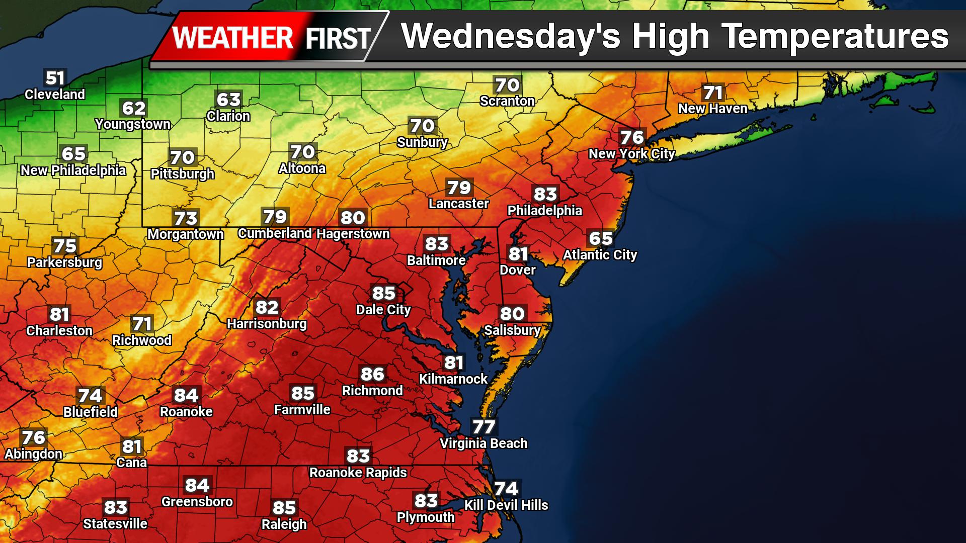
A significant early-season warm-up is underway across the Delmarva region, with temperatures to surge well above normal through the middle of the week and into the upcoming weekend. Forecast confidence continues to increase that some locations to challenge or even break daily temperature records.
High pressure anchored over the Atlantic Ocean, combined with a warm front positioned well north of the region, is allowing a strong southwest flow to transport unusually warm air into the Delmarva Peninsula. Both surface and upper-level conditions are aligning to support temperatures running 20 to 40 degrees above average for this time of year.
By Tuesday, inland areas across Delaware and Maryland’s Eastern Shore are expected to climb into the low to mid 80s. The peak of the heat arrives Wednesday and Thursday, when many inland communities, including areas around Salisbury, Cambridge, and Dover, could reach the upper 80s to near 90 degrees. If temperatures hit 90°, it would mark the first 90-degree day of the year and the first since early September.
Coastal communities, such as Ocean City and Rehoboth Beach, will once again see a noticeable difference. Cooler ocean temperatures will promote a daily sea breeze, keeping highs closer to the 70s, especially during the afternoon hours.
A weak front is expected to pass through late Thursday night into early Friday, but it will do little to disrupt the overall warm pattern. Temperatures will remain well above normal heading into the weekend, generally ranging from the mid 70s to mid 80s across the region.
Despite the heat, conditions will remain largely dry. Only a very limited chance exists for an isolated shower or thunderstorm, mainly well north of the Delmarva region. This lack of rainfall is a growing concern, as ongoing abnormally dry to drought conditions across portions of the peninsula may worsen through the week.
While warm and dry weather can sometimes elevate fire risk, that threat remains relatively low for now. Light winds and a modest increase in low-level moisture from the southwest flow should help limit more critical fire weather concerns.
Residents of remote U.S. Pacific territories are battening down as Super Typhoon Sinlaku unleashes devastating winds and torrential rains, causing structures to crumble and debris to become deadly projectiles.
“It’s hitting us hard,” said Mayor Ramon “RB” Jose Blas Camacho of Saipan during the nighttime assault. “It’s so difficult for us to respond with this heavy rain, heavy wind to rescue people. Objects are just flying left and right.”
Camacho reported that rescue operations have saved some residents, while trees are being hurled through the air and wooden and metal structures are collapsing. Even his office is under threat as the glass door flexes under the storm’s power.
“It’s already bending. That’s how powerful this is,” he explained.
The monster storm is crawling toward Saipan, the main island in the Northern Mariana chain, at just 3 mph. Weather officials warn conditions will deteriorate further through the night.
According to the Navy’s Joint Typhoon Warning Center in Guam, Sinlaku has intensified to 150 mph winds. Forecasters say the storm will make landfall “imminently” near Tinian, located roughly 6 miles from Saipan, or the uninhabited Aguijan island.
The typhoon’s sluggish pace has officials particularly worried.
“That’s the scary part,” Camacho noted, adding “it’s better to speed up so it can just exit.”
To the south, Guam – a U.S. territory housing multiple American military bases and approximately 170,000 people – is experiencing “torrential rainfall” and “ongoing flash flooding,” weather officials reported. “We ask that everyone remain indoors and away from windows.”
National Weather Service meteorologist Landon Aydlett in Guam characterized the typhoon as moving at “a very slow gradual crawl” Tuesday evening.
“The slow motion means destructive winds in excess of 150 miles an hour will be prolonged once they arrive” at Tinian and Saipan, Aydlett warned.
“This is an extremely dangerous and life-threatening situation,” he emphasized.
Dangerous flash flooding is forecast to persist across both islands through Wednesday. Approximately 50,000 people inhabit three islands in the region, with Saipan hosting the largest population and serving as the capital, famous for its relaxed resorts, diving opportunities, and golf courses.
Despite predictions that Sinlaku will weaken somewhat in coming days, it’s expected to pass through the islands as a Category 4 or 5 typhoon.
Saipan holds historical significance as the location of one of the Pacific Theater’s most devastating World War II battles, claiming over 50,000 Japanese and American military personnel and civilian lives.
On Guam, where Typhoon Mawar caused extended power outages in 2023, U.S. military commanders have instructed personnel to prepare for the storm and remain sheltered. Military installations occupy roughly one-third of this strategically important Pacific hub.
Prior to targeting Guam and the Northern Marianas, the storm caused substantial destruction across Chuuk’s outer islands and atolls in the Federated States of Micronesia, meteorologist Landon Aydlett confirmed.
Glen Hunter, a Saipan native experienced with typhoons, described the situation after awakening to powerful gusts and fallen trees.
“We sit in what they call ‘Typhoon Alley,’” he said early Tuesday.
Hunter explained that most islanders live in solid concrete homes, while those in weaker wooden structures with metal roofing typically stay with relatives or in government shelters during storms.
Tourism-reliant Saipan was still rebuilding from 2018’s Super Typhoon Yutu when the COVID-19 pandemic struck in 2020, Hunter remembered. The local economy remains struggling, he noted.
President Donald Trump authorized emergency disaster declarations for Guam and the Northern Mariana Islands on Saturday, enabling additional emergency assistance.
The Federal Emergency Management Agency announced it’s organizing multi-agency support, deploying almost 100 FEMA personnel along with staff from the Environmental Protection Agency, Department of Transportation, and U.S. Army Corps of Engineers.
Super typhoons represent the most powerful tropical cyclones that develop in the northwestern Pacific Ocean, Earth’s breeding ground for the most severe storms.
Tracked by Guam’s Joint Typhoon Warning Center, super typhoons match Category 4 or 5 Atlantic hurricanes in intensity, featuring winds of at least 150 mph. More than 300 super typhoons have been documented since the warning center began using this classification nearly 80 years ago.
MAMMOTH LAKES, Calif. — A powerful weekend storm brought more than 3.5 feet of fresh snow to California’s eastern Sierra Nevada mountains, temporarily shuttering a major highway and giving Mammoth Mountain an unexpected opportunity to keep its slopes open longer.
The late-season snowfall arrived just weeks following a March heat wave that melted significant portions of California’s snowpack, compelling numerous ski facilities to end their seasons early. Additional snow remained in the forecast for Monday.
By April 1st, the Sierra snowpack — which supplies one-third of California’s water resources — measured only 18% of normal levels based on readings taken in mountains near Lake Tahoe. This marked the second-lowest measurement recorded for that date in history.
Between Friday and Sunday, the UC Berkeley Central Sierra Snow Lab documented 42.5 inches of accumulation, noting it “has been great to create a late-season snowpack.”
“Unfortunately, record warm temps this winter means that we’re still well below average for the water year,” the laboratory posted on social media.
Blizzard conditions forced authorities to close Interstate 80 in Northern California on Sunday, while chain requirements remained in effect Monday morning for the vital corridor linking San Francisco and Lake Tahoe.
The weather system also delivered powerful winds, intense rainfall and hail throughout many regions. Near Sacramento, a tornado made contact with the ground Sunday, though the National Weather Service reported no resulting damage.
Mammoth Mountain operated 11 chairlifts on Monday as conditions improved. While skies were becoming clearer, the resort’s daily update indicated another few inches of snow could still fall.
“While fresh snow may look inviting, hazards like dirt, rocks, and bushes remain just below the surface. Ski and ride with caution and avoid venturing off trail,” the resort’s report cautioned.
Throughout much of the western United States, snow had been disappearing following an unusually warm winter that created poor skiing conditions before giving way to record-breaking spring temperatures. Colorado this month recorded its most severe snowpack deficit since comprehensive state tracking began in 1941.
Authorities cautioned that these measurements clearly indicate potential worsening of water shortages amid the current substantial drought, unless unexpected heavy precipitation occurs.
Regional municipalities are implementing water usage limitations, while ranchers face uncertainty about feeding and watering their livestock. The possibility of catastrophic wildfire activity continues to threaten the area.
Remote U.S. territories in the Pacific are bracing for impact as Super Typhoon Sinlaku, Earth’s most powerful storm this year, approaches with devastating force.
The National Weather Service announced Monday that Sinlaku is projected to strike the Northern Mariana Islands on Tuesday, delivering catastrophic winds, torrential rainfall, and severe flooding to the region.
Guam, home to critical U.S. military bases, faces the threat of damaging winds starting Monday and remains under a tropical storm warning. Weekend advisories from the U.S. Coast Guard alerted residents to prepare for flooding and dangerous wind conditions.
As of Monday, this record-breaking typhoon was generating continuous winds of 173 mph as it moved toward Rota, Tinian, and Saipan, data from the Joint Typhoon Warning Center shows.
Though forecasters predict some weakening in coming days, Sinlaku is still anticipated to pass through the island chain as either a Category 4 or 5 storm.
Military leadership in Guam has instructed service members to make storm preparations and remain in secure locations. The territory is still recovering from Typhoon Mawar, which left residents without electricity for extended periods in 2023.
On Saturday, President Donald Trump granted emergency disaster status to both Guam and the Northern Mariana Islands, unlocking federal resources for emergency response efforts.
Super typhoons represent the most formidable tropical weather systems that develop in the northwestern Pacific, Earth’s breeding ground for the planet’s most violent storms.
These massive weather events, tracked by the Joint Typhoon Warning Center based in Guam, match the intensity of Atlantic Category 4 or 5 hurricanes, featuring winds that exceed 150 mph. Since the warning center began using this classification in 1947, more than 300 super typhoons have been documented.
A significant warm-up is underway across the Delmarva region, with the potential for record-breaking temperatures through the middle and end of the week. After a seasonable start, a strong pattern shift will bring much warmer-than-normal conditions, with temperatures running 20 to 30 degrees above average across Delaware and Maryland’s Eastern Shore, as well as nearby coastal areas.
By Tuesday, inland areas such as Salisbury, Cambridge, and Dover are expected to climb into the low to mid 80s, with even hotter conditions arriving Wednesday and possibly Thursday. High temperatures could surge into the upper 80s to near 90 degrees, especially across interior sections of Delmarva. If 90 degrees is reached, it would mark the first 90-degree day of the year, and the first occurrence since early September.
However, as is typical this time of year, coastal communities including Ocean City, Rehoboth Beach, and Lewes will likely remain cooler. The colder Atlantic Ocean waters will help generate a daily sea breeze, keeping temperatures closer to the 60s and 70s along the immediate coastline while inland areas heat up significantly.
This unusually warm pattern is being driven by high pressure anchored over the Atlantic, combined with a warm front lifting well north of the Mid-Atlantic. This setup is allowing a deep layer of warm air to overspread the region, both at the surface and aloft.
Despite a weak cold front expected to pass through late Thursday night into Friday morning, the overall pattern will remain warm. Temperatures heading into the weekend are still forecast to stay well above normal, generally ranging from the upper 70s to mid 80s across much of Delmarva.
In addition to the heat, the region will remain mostly dry, raising concerns about ongoing abnormally dry to drought conditions. While a few weak disturbances may pass to the north between Tuesday and Thursday, only a stray shower or thunderstorm is possible, mainly well north of the region. No widespread or meaningful rainfall is expected, which could allow drought conditions to worsen.
The good news is that fire weather concerns remain limited for now. Although conditions will be warm and dry, light winds and a more humid southwest flow should help prevent rapid fire spread.
Overall, Delmarva is heading into an extended stretch of early summer-like warmth, with the potential for record highs, continued dry conditions, and noticeable differences between inland and coastal temperatures.
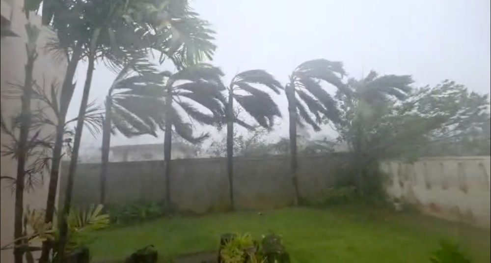
A powerful cyclone struck New Zealand’s North Island on Sunday, leaving thousands without electricity and prompting mass evacuations as weather officials cautioned that conditions would deteriorate further throughout the day.
Cyclone Vaianu delivered damaging winds surpassing 81 mph, torrential rainfall, and massive ocean swells before its anticipated afternoon landfall, MetService, the nation’s weather agency, reported.
Officials declared emergency status across multiple regions and issued the highest-level “red” wind alerts, typically reserved for the most severe weather emergencies.
Emergency Management Minister Mark Mitchell reported that the storm was moving along “more towards the fringes” of the North Island, allowing Auckland – New Zealand’s largest metropolitan area – to avoid the most devastating impacts. However, he cautioned that more powerful winds and swells were anticipated as the cyclone reached shore.
“It’s moved more to the fringes and more to the east, which means that we haven’t quite seen the intensity that we had prepared for or that we thought we were going to get hit with. So that is good news,” Mitchell stated.
“In terms of what we’re going to expect over the next 12 hours is we are going to see a bit more of intensification, as the cyclone starts to come down and get closer.”
Mitchell cautioned that the afternoon’s peak tide combined with powerful storm surges could create dangerous coastal flooding conditions.
“The concerning time is really from 2 p.m. this afternoon onwards when we’ve got high tides combined with those big swells,” he explained.
The storm has displaced hundreds of people from their homes and disrupted power service to approximately 5,000 residences, though electricity has been restored to about 2,000 properties, Mitchell noted.
Military personnel and specialized equipment from the New Zealand Defence Force have been mobilized to support evacuation efforts.
Weather monitoring stations recorded wind speeds exceeding 81 mph in certain locations and measured more than 3.9 inches of rainfall over 24 hours in Whangarei, MetService data showed.
The current storm has revived painful memories of 2023’s devastating Cyclone Gabrielle, which claimed 11 lives and forced thousands from their homes in what became one of New Zealand’s most catastrophic natural disasters in recent decades.
Authorities across New Zealand’s North Island issued mandatory evacuation orders Saturday for thousands of residents as Cyclone Vaianu approaches with potentially devastating force.
The powerful storm system is predicted to deliver torrential rainfall and sustained winds reaching 80 mph when it makes landfall Sunday, according to national weather officials. The cyclone is then projected to move past the isolated Chatham Islands by Monday.
Emergency declarations were activated across multiple regions Saturday, with mandatory evacuations issued for portions of Whakatane, a community of 37,150 located approximately 270 miles north of the capital city Wellington.
Local officials warned residents through social media to prepare for an extended displacement. “Residents should plan to be away for at least two days,” the Whakatane District Council announced on Facebook. The council cautioned that coastal communities face threats from landslides, dangerous storm surge, towering waves reaching 43 feet in height, and significant coastal flooding.
On Friday, Prime Minister Christopher Luxon emphasized the serious threat posed by the approaching weather system and called on citizens in the storm’s trajectory to take immediate protective measures.
“Make sure drains are free, check in on the neighbours, and be prepared for possible power cuts,” Luxon advised through social media.
The approaching cyclone has rekindled memories of the devastating Cyclone Gabrielle that struck in 2023, claiming 11 lives and forcing thousands from their homes in what became New Zealand’s most severe natural disaster of the century.
A big warm-up is on the way across Delmarva over the next several days.
We’ll start off on a quieter note this weekend, with mostly sunny skies Saturday and highs in the upper 60s. Sunday stays pleasant as well, with a mix of sun and clouds and temperatures in the mid 60s.
By early next week, a noticeable shift begins. Temperatures jump into the 80s Monday, and continue climbing through midweek. Highs reach the mid 80s Tuesday, with upper 80s possible by Wednesday, making it feel more like early summer across the region.
Conditions remain fairly quiet overall, with a mix of sun and clouds each day. Overnight lows also trend much warmer, rising from the 40s this weekend into the 60s by midweek.
If you’ve been waiting for consistent warm weather, it’s arriving in a big way across Delmarva. Just keep in mind, with the warmer temperatures and dry stretch, pollen levels will likely remain elevated as well.
Dense fog has descended upon Delaware, creating hazardous driving conditions across the First State and prompting safety warnings for all travelers.
The Delaware Department of Transportation reports that visibility has been significantly reduced due to fog formations of different intensities affecting roadways statewide. Officials are strongly encouraging all drivers to exercise heightened caution and adjust their driving habits accordingly.
Motorists should reduce their speed, increase following distances, and use low-beam headlights while navigating through the foggy conditions. Drivers are also advised to avoid using high-beam headlights, which can reflect off the fog and further reduce visibility.
The weather conditions are expected to impact travel times and may cause delays for commuters throughout the region.
A noticeable shift toward much warmer weather is expected across the Delmarva Peninsula as we head into early and mid next week, bringing the first widespread taste of summer-like conditions this season.
Following a seasonable and relatively comfortable weekend, high pressure will build back into the region in the wake of a departing cold front. This setup will quickly transition into a return flow pattern, allowing warmer air from the south to surge northward across Delaware, Maryland’s Eastern Shore, and coastal Virginia.
By Tuesday and especially into Wednesday, temperatures are forecast to climb well above average. Many inland locations across Delmarva, including areas like Salisbury, Easton, Dover, and Georgetown, could see afternoon highs push well into the 80s. Even coastal communities, which are often moderated by cooler ocean waters, should see a notable warm-up, though slightly lower than inland areas.
In addition to the daytime warmth, overnight temperatures will also trend much milder than recent nights. Lows are expected to remain in the 60s, marking a significant departure from the cooler conditions experienced recently. This combination of warm days and mild nights will create a sustained stretch of above-normal temperatures across the region.
For the most part, dry weather is expected to dominate through at least the middle of the week. However, a weak disturbance may bring a slight chance for a few showers Monday night, primarily across northern portions of the region such as Kent and northern Queen Anne’s counties. Most areas, especially across southern Delaware and the lower Eastern Shore, are expected to remain dry during this time.
Looking ahead, the next more organized chance for precipitation may arrive by Wednesday as a cold front begins to approach from the northwest. The timing and strength of this system will determine whether showers or thunderstorms develop, but for now, the primary story remains the unseasonably warm temperatures building across Delmarva.
MATTAPONI—After nearly three decades of handling insurance claims throughout Virginia’s Upper Tidewater area, Mike Pumo has witnessed firsthand just how destructive Mother Nature can be. The Virginia Farm Bureau Mutual Insurance Co. representative, who operates out of King & Queen County, has assisted countless clients dealing with hurricane-related wind and flood damage over the years.
“But spring storms can be very violent too,” Pumo said.
Pumo vividly remembers the destruction caused in May 2018 when two powerful derecho systems tore through the mid-Atlantic region. These intense storm systems created a devastating path of destruction stretching approximately 470 miles from Ohio down to Virginia.
“Those strong, straight-line winds lifted and completely flipped over one of my client’s machine sheds in New Kent County,” he recalled.
The destroyed building had served as storage for farming equipment used in the client’s row crop business. Despite being newly built with quality wooden pole construction, the structure couldn’t withstand the storm’s fury.
“Unfortunately, the wind blew straight into the open end, ripped it out of the ground, and flipped it completely over backwards,” Pumo said, describing his visit to evaluate the destruction that same day. “I remember thinking, holy cow, I can’t believe it did that! The force of nature is crazy. And it’s not like that shed was poorly built. The wind ripped the poles right off.”
Following the insurance claim process, the farmer rebuilt using steel posts and trusses for better durability.
Although such devastating weather events remain unpredictable, property owners can implement several protective measures as spring approaches.
“Spring storms can happen anywhere in the state,” said VFBMIC director of property claims David Jewell. “That’s when we see a lot of wind and hail. We see more flooding with storms later in the year.”
Property owners can visit ready.gov/alerts to sign up for severe weather alerts.
Jewell recommends completing preventive maintenance before spring storm season arrives, including trimming trees and clearing dead branches near homes, plus fixing any damaged or loose roofing materials. When severe weather threatens, he suggests securing outdoor items like furniture, grills and decorations that could become dangerous projectiles.
“And be prepared for power outages too,” he added. Keep an emergency kit with flashlights, extra batteries, a weather radio, first-aid items, medications, documents, cash, blankets, non-perishable food and multi-day supply of bottled water.
Pumo emphasizes the importance of maintaining proper insurance protection against storm damage. Discussing coverage options with an insurance professional beforehand can prevent costly surprises following a natural disaster.
Visit vafb.com/natural-disaster-safety/severe-storms for tips on storm preparation or enter your ZIP code at vafb.com/locations to find a VFBMIC agent nearby.
Media: Contact Pumo at 804-785-9431; or Jewell at 800-828-6862.
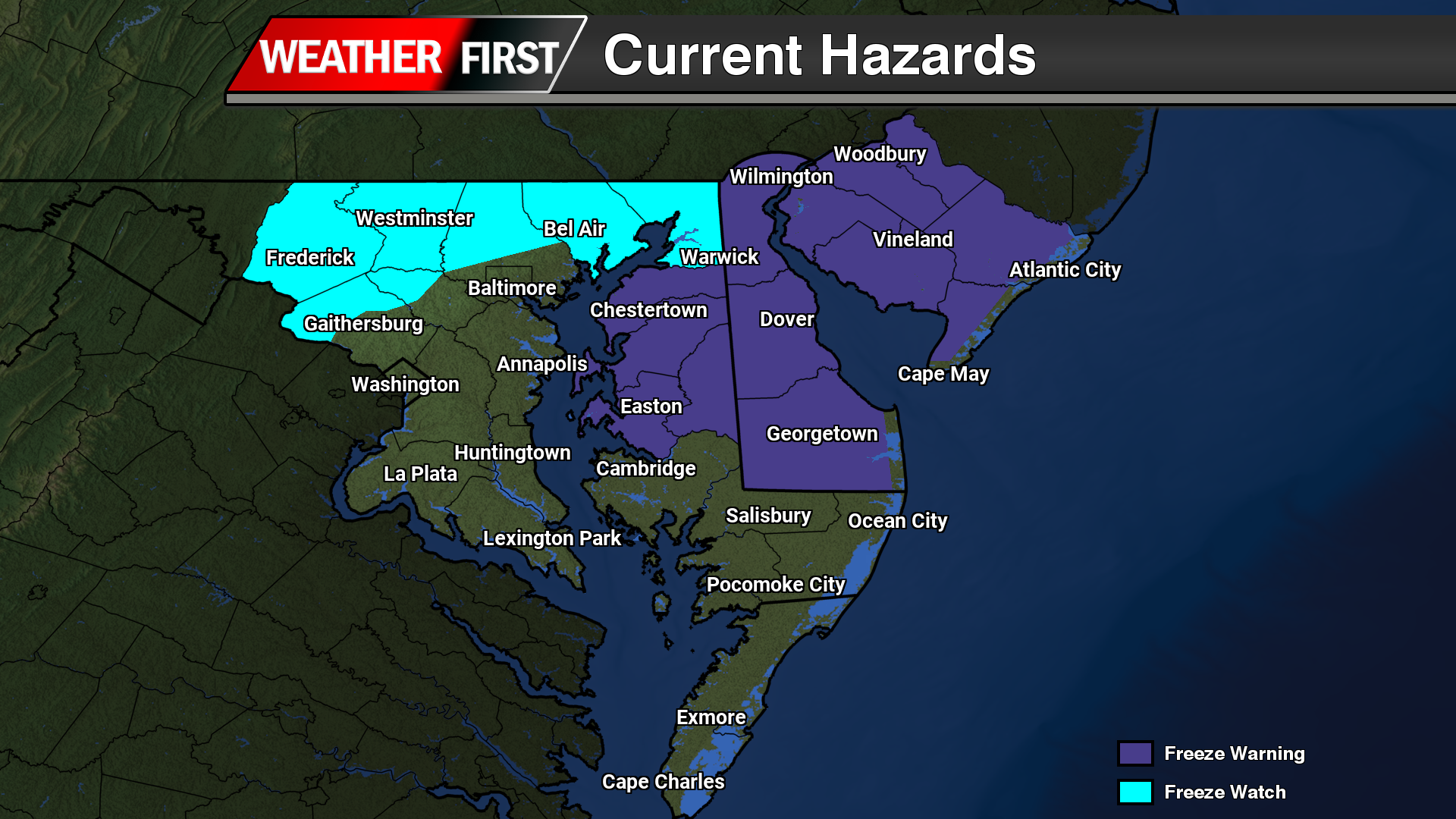
Weather officials have issued a freeze warning for Tuesday morning, alerting residents to prepare for potentially damaging cold temperatures.
The National Weather Service office in Mount Holly, New Jersey issued the warning at 2:34 AM on April 9th, with the advisory remaining in effect until 9:00 AM the same day.
The brief but intense cold snap comes as an unexpected weather pattern for this time in April, when temperatures typically begin warming for spring.
Residents should take precautions to protect sensitive plants, outdoor plumbing, and pets during the warning period. The freeze conditions could damage or kill unprotected vegetation and crops.
The National Weather Service office in Mount Holly, New Jersey has issued a freeze warning that took effect Monday evening at 9:52 PM and will remain in place until 9:00 AM Tuesday morning.
The warning alerts residents to prepare for freezing temperatures that could damage sensitive vegetation and cause problems with exposed outdoor plumbing.
Gardeners and homeowners are advised to bring in potted plants, cover tender garden plants, and ensure outdoor water pipes are protected from the cold.
The freeze warning comes as unseasonably cold air moves through the region overnight, creating conditions that could harm plants that have already begun their spring growth.
Federal weather officials have confirmed that March delivered such extraordinary heat across the continental United States that it now holds the distinction of being the most unusually warm month in 132 years of temperature tracking.
According to data released Wednesday by the National Oceanic and Atmospheric Administration, March didn’t just break the record for hottest March ever recorded – it surpassed every other month in history for how far above normal temperatures climbed across the Lower 48 states. The month averaged 50.85 degrees Fahrenheit, soaring 9.35 degrees beyond the typical March temperature from the 20th century. This easily topped the previous record of 8.9 degrees above normal, which was also set during March 2012.
Daytime temperatures were particularly extreme, with maximum temperatures running 11.4 degrees higher than the 20th century average for March. NOAA noted these daily highs were nearly a full degree warmer than what’s typically seen during April.
The recent pattern of unusual warmth is becoming more frequent, with six of the nation’s ten most abnormally hot months occurring within the past decade. Even February ranked as the tenth most above-normal month, running 6.57 degrees warmer than historical averages.
Climate Central meteorologist Shel Winkley emphasized the significance of these conditions. “What we experienced in March across the United States was unprecedented,” Winkley stated. “One reason that’s so concerning is just the sheer volume of records, all-time records that were set and broken during that time period. But also this is coming on the heels of what was the worst snow year. And the hottest winter of record. So we’re seeing this continuation of extraordinary heat that took place during the winter months, continuing into the spring months as well. That’s where it’s really concerning, it’s just the duration of this heat.”
The widespread nature of the heat wave becomes clear when examining the numbers: meteorologist Guy Walton, who tracks NOAA statistics, reported that more than 19,800 daily temperature records were broken nationwide during March.
Weather experts warn that global temperatures may continue climbing over the next year, with some forecasts suggesting a developing El Nino weather pattern could reach exceptional strength.
A prolonged stretch of dry weather is expected to continue across the Delmarva Peninsula through the remainder of the week and likely into much of the upcoming weekend, as high pressure remains firmly in control of the region.
This expansive area of high pressure is currently centered over the Mid-Atlantic, providing clear skies and stable conditions. As a result, no meaningful precipitation is expected through the end of the workweek.
Despite the quiet weather, a very dry air mass will settle in, particularly midweek. Minimum relative humidity values are expected to drop into the 20 to 30 percent range, especially on Wednesday. While this is similar to earlier fire weather concerns, lighter winds will help limit the overall risk for rapid fire spread compared to previous days.
As the high pressure system gradually shifts offshore later this week, winds will turn out of the southeast on Thursday and southwest by Friday. This will allow humidity levels to slowly increase, though conditions will remain dry overall with no significant rainfall expected.
A weak cold front is forecast to slide southeast across Delmarva Friday night into early Saturday. However, moisture with this system appears limited, and only a slight chance of precipitation is expected at this time.
Behind the front, another area of high pressure is expected to build in, reinforcing dry conditions through the weekend. Temperatures will remain mild to warm, setting the stage for a notable warm-up early next week.
High temperatures are forecast to climb well into the 70s by Monday, with many areas likely reaching the 80s by Tuesday, marking a return to above-normal temperatures across the region.
While the stretch of dry and warm weather may be welcome for outdoor plans, the continued lack of rainfall could begin to raise concerns for drying soils and vegetation across Delmarva if the pattern persists.
A widespread freeze is expected to impact the Delmarva region tonight into Thursday morning, prompting a Freeze Warning for much of the area.
The warning goes into effect at 10 PM this evening and continues through 9 AM Thursday, covering central, northern, and southern Delaware, along with portions of northeast Maryland and southern New Jersey.
Temperatures could fall as low as 28 degrees overnight as a cold, dry air mass settles across the region. Clear skies and light winds will create ideal conditions for rapid cooling, allowing temperatures to drop below freezing in many locations.
These conditions pose a significant threat to early-season vegetation. Frost and freezing temperatures can kill sensitive plants, damage crops, and impact blooming trees and flowers that have already begun growing due to recent warm weather.
Residents across Delmarva are urged to take precautions ahead of the cold. Bringing potted plants indoors, covering gardens, and protecting exposed pipes can help reduce damage from the freeze.
Temperatures are expected to rebound after sunrise Thursday, bringing an end to the immediate freeze threat, but the cold start could have lasting impacts on agriculture and landscaping across the region.
The National Weather Service office in Mount Holly, New Jersey has issued a freeze warning for the region that will remain in effect from Monday evening through Tuesday morning.
The weather alert was issued on April 8th at 8:55 AM Eastern Daylight Time and will continue until April 9th at 9:00 AM EDT.
Residents should take precautions to protect sensitive plants and outdoor plumbing during this period of freezing temperatures. The warning indicates that sub-freezing conditions are expected that could damage or kill crops, other sensitive vegetation, and potentially cause problems with unprotected outdoor water pipes.
Weather officials have issued a freeze warning for the region, cautioning residents about dangerously cold temperatures expected during the early morning hours of April 8th.
The National Weather Service office in Mount Holly, New Jersey, activated the warning at 3:00 AM EDT on April 8th, with the alert remaining in effect until 9:00 AM the same day.
The six-hour warning period covers the coldest part of the morning when freezing temperatures are most likely to occur and cause damage to temperature-sensitive plants and vegetation.
Residents are advised to take precautions to protect any outdoor plants, gardens, or crops that could be harmed by the freezing conditions during this timeframe.
Weather officials have issued a freeze warning for the region, alerting residents to dangerously cold temperatures expected during the early morning hours of April 8th.
The National Weather Service office in Mount Holly, New Jersey announced the warning at 3:00 AM EDT, with the advisory remaining in effect until 9:00 AM EDT the same day.
The warning indicates that freezing temperatures are anticipated during this six-hour window, posing potential risks to sensitive plants, crops, and outdoor vegetation that may have emerged with recent warmer spring weather.
Residents are advised to take precautionary measures to protect tender plants and ensure proper preparation for the cold snap during these morning hours.
Weather officials have issued a freeze watch effective Monday at 3:00 AM EDT continuing through Tuesday morning at 9:00 AM EDT, according to the National Weather Service Mount Holly office.
The alert warns residents across the region to prepare for potentially damaging cold temperatures that could affect sensitive vegetation and outdoor plumbing.
Residents are advised to take precautions to protect plants, pets, and pipes during the cold snap. The freeze watch indicates that conditions are favorable for temperatures to drop to levels that could cause frost formation.
The National Weather Service Mount Holly office will continue monitoring conditions and may update the alert as weather patterns develop.
Weather officials have issued a freeze watch that will remain in effect from Monday night through Tuesday morning, warning residents to prepare for potentially damaging cold temperatures.
The National Weather Service office in Mount Holly, New Jersey activated the freeze watch starting at 3:00 AM on April 8th, with the advisory continuing until 9:00 AM on April 9th.
Residents should take precautions to protect sensitive plants and outdoor plumbing during this period of freezing temperatures. The timing of the freeze watch covers the overnight hours when temperatures typically reach their lowest point.
Weather officials have issued a freeze warning that will remain in effect from Sunday afternoon at 2:18 PM through Monday morning at 9:00 AM, according to the National Weather Service office in Mount Holly, New Jersey.
The warning alerts residents and farmers to prepare for subfreezing temperatures that could damage sensitive plants, crops, and outdoor vegetation during the overnight hours.
Those with gardens or temperature-sensitive plants are advised to take protective measures before the cold temperatures arrive Sunday evening.
Weather officials have issued a freeze warning for the region, alerting residents to prepare for potentially damaging overnight temperatures.
The National Weather Service office in Mount Holly, New Jersey announced the freeze warning on Sunday, April 7th at 2:18 PM Eastern Daylight Time. The warning remains in effect until 9:00 AM Eastern Daylight Time on Monday, April 8th.
During this period, temperatures are expected to drop to freezing levels, which could harm sensitive vegetation and outdoor plants. Residents are advised to take precautions to protect tender plants and outdoor plumbing from potential freeze damage.
The weather service typically issues these warnings when sub-freezing temperatures are forecast during the growing season, when such conditions could cause significant damage to plants, crops, and other temperature-sensitive materials.
Weather authorities have announced a freeze watch affecting the region, beginning Sunday afternoon and continuing until Tuesday morning at 9:00 AM.
The National Weather Service office in Mount Holly, New Jersey issued the cold weather advisory on April 7th at 2:18 PM Eastern Daylight Time. The watch will remain in effect until April 9th at 9:00 AM EDT.
Residents should take precautions to protect sensitive plants, outdoor plumbing, and other items that could be damaged by freezing temperatures during this period.
Weather officials have issued a freeze watch for the area, warning residents to prepare for dangerously cold conditions beginning Sunday afternoon.
The National Weather Service office in Mount Holly, New Jersey announced the alert at 2:18 PM on April 7th, with the watch remaining in effect until 9:00 AM on April 9th.
During this period, temperatures are expected to drop to levels that could cause damage to sensitive plants and create hazardous conditions for exposed water pipes and outdoor equipment.
Residents are advised to take precautionary measures to protect their property and prepare for the unseasonably cold weather during what is typically a milder time of year.
Weather forecasters have issued a freeze warning beginning Sunday at 11:01 AM EDT and continuing until Monday morning at 9:00 AM EDT, according to the National Weather Service office in Mount Holly, New Jersey.
The warning alerts residents to prepare for potentially damaging cold temperatures that could harm sensitive vegetation and outdoor plants. Officials recommend taking precautions to protect tender plants and ensure proper winterization of outdoor plumbing and equipment.
The freeze warning covers the period when temperatures are expected to drop to levels that could cause frost formation and potential agricultural impacts. Residents should monitor local weather conditions and take appropriate measures to safeguard temperature-sensitive items.
Weather officials have issued a freeze warning for the region that will remain in effect from Sunday evening through Monday morning.
The National Weather Service office in Mount Holly, New Jersey issued the alert on Sunday at 11:01 AM, with the warning period extending until 9:00 AM on Monday.
Temperatures are expected to drop to levels that could cause damage to sensitive vegetation and crops during the overnight hours. Residents are advised to take precautions to protect any tender plants or agricultural products that could be affected by the freezing conditions.
The weather service typically issues freeze warnings when temperatures are forecast to drop to 32 degrees Fahrenheit or below for an extended period, particularly during growing season when such conditions could cause significant agricultural or horticultural damage.
Weather officials have issued a freeze watch for the region, warning residents to prepare for dangerously cold temperatures over the next few days.
The National Weather Service office in Mount Holly, New Jersey announced the alert on Sunday at 11:01 AM, with the watch remaining in effect until 9:00 AM on Tuesday, April 9th.
The freeze watch indicates conditions are favorable for temperatures to drop to levels that could damage sensitive vegetation and pose risks to exposed pipes and outdoor water systems.
Residents are advised to take precautions to protect tender plants by covering them or bringing potted plants indoors. Property owners should also consider draining outdoor water lines and covering exposed plumbing to prevent freeze damage.
The weather service will continue monitoring conditions and may upgrade the watch to a freeze warning if temperatures are expected to reach more severe levels.
The National Weather Service office in Mount Holly, New Jersey has announced a freeze watch that went into effect Sunday at 11:01 AM and will remain active until Tuesday morning at 9:00 AM.
The alert warns residents to prepare for freezing conditions that could pose risks to temperature-sensitive vegetation and exposed water pipes. This unseasonably cold weather pattern is expected to bring temperatures low enough to cause frost formation across the coverage area.
Homeowners are advised to take precautionary measures such as covering delicate plants, bringing potted flowers indoors, and ensuring outdoor faucets and irrigation systems are protected from potential freeze damage.
The weather service will continue monitoring conditions and may update the alert as the situation develops over the next 48 hours.
A sharp drop in temperatures will bring widespread freeze conditions to Delmarva early Wednesday morning, with additional frost concerns lingering into Thursday morning.
A strong Canadian high pressure system, centered around 1040 mb, will build into the Northeast behind a cold front that moved through Tuesday. This setup is allowing a reinforcing surge of cold, dry air to settle over the Delmarva Peninsula through midweek.
Temperatures by Wednesday morning are expected to fall into the mid 20s to low 30s across much of Delaware and Maryland’s Eastern Shore. As a result, Freeze Warnings are now in effect, especially as the growing season has recently begun across the region. These temperatures are cold enough to damage or kill sensitive vegetation if proper precautions are not taken.
Despite the cold start Wednesday, the air mass will initially remain very dry, limiting frost development early in the morning. However, conditions will change heading into Wednesday night.
As high pressure shifts offshore, winds will become lighter and turn easterly, allowing moisture to recover slightly. This will set the stage for efficient radiational cooling Wednesday night into early Thursday morning. Temperatures will once again drop into the mid 20s to low 30s inland, with slightly milder readings closer to the immediate coastline.
Unlike the previous night, these conditions will be more favorable for widespread frost formation, particularly across inland areas of Delmarva where winds go calm and skies remain clear. Even near the coast, patchy frost cannot be ruled out if winds diminish enough overnight.
Conditions will begin to moderate by Thursday afternoon and into Friday, with temperatures gradually trending closer to seasonal norms. However, another chilly start is expected Thursday morning, and some patchy frost may still develop in typically cooler inland locations early Friday, though a hard freeze is not anticipated beyond Thursday morning.
There is an elevated risk for fire spread today for the Eastern Shore of Maryland and Delaware. Minimum relative humidity values will drop to around 25 percent this afternoon. This will be accompanied by northwesterly winds 15 to 20 mph with gusts 25 to 35 mph. These conditions, along with the continued drying of fine fuels, could support the rapid spread of any fires that ignite, which could quickly become difficult to control. Conditions improve this evening as the wind diminishes and the relative humidity increases.
Outdoor burning is strongly discouraged. Be sure to properly extinguish or dispose of any potential ignition sources, including smoking materials such as cigarette butts.
This forecast considers meteorological, fuel, and land conditions and has been developed in coordination with state fire officials.
Weather officials have issued a freeze warning for the region that started at 2:19 AM on Sunday and will continue through 9:00 AM on Monday morning.
The National Weather Service office in Mount Holly, New Jersey announced the alert as temperatures are forecast to dip below freezing during the overnight hours.
The warning indicates that sub-freezing temperatures could cause significant damage to plants, crops, and other temperature-sensitive vegetation in the area.
Residents are advised to take precautions to protect tender plants and outdoor plumbing during this cold weather event.
Weather officials have issued a freeze warning that took effect at 2:19 AM on Sunday, April 7th and will remain in place until 9:00 AM on Monday, April 8th.
The National Weather Service office in Mount Holly, New Jersey issued the alert, warning residents that freezing temperatures are expected during the overnight hours.
The warning indicates that sub-freezing temperatures could pose risks to sensitive plants, crops, and outdoor vegetation that may have already begun spring growth.
Residents are advised to take protective measures for any tender plants or agricultural crops that could be damaged by the freezing conditions expected during this period.
Weather officials have issued a freeze watch for the region that will remain in effect from early Sunday morning through Tuesday morning at 9:00 AM.
The National Weather Service office in Mount Holly, New Jersey announced the cold weather advisory at 2:19 AM on Sunday, April 7th, warning residents to prepare for potentially damaging freezing conditions.
The watch will continue until 9:00 AM on Tuesday, April 9th, giving residents time to protect sensitive outdoor plants and take necessary precautions against the unseasonably cold temperatures.
Gardeners and homeowners are advised to cover or bring indoors any tender plants that could be damaged by frost during this period.
Weather officials have announced a freeze watch that began early Sunday morning and will remain in effect until 9:00 AM on Tuesday, according to the National Weather Service office in Mount Holly, New Jersey.
The alert, which was issued at 2:19 AM on Sunday, warns residents to prepare for freezing conditions that could damage tender vegetation and exposed water pipes.
During a freeze watch, temperatures are expected to drop to 32 degrees Fahrenheit or below, creating potentially harmful conditions for plants that have begun their spring growth cycle.
Residents are advised to take precautions to protect sensitive plants by covering them or bringing potted plants indoors. Property owners should also ensure that any exposed plumbing is properly insulated to prevent freezing and potential pipe damage.
The cold snap comes as many areas have experienced warmer spring-like weather in recent weeks, making the sudden temperature drop particularly concerning for early-blooming plants and newly planted gardens.
Delaware residents should prepare for a significant drop in temperatures as the National Weather Service Mount Holly office has issued a freeze watch beginning Saturday evening at 9:36 PM and extending until Monday morning at 9:00 AM.
The weather alert warns that freezing temperatures could develop across the region during this timeframe, potentially causing damage to sensitive outdoor plants and vegetation.
Residents are advised to take precautionary measures to protect tender plants, outdoor plumbing, and other temperature-sensitive items during the expected cold snap.
The freeze watch indicates conditions will be favorable for widespread frost and freezing temperatures, which could impact agricultural operations and home gardens throughout the First State.
Weather officials have issued a freeze watch for the Delaware area that began Saturday afternoon and will continue through Monday morning.
The National Weather Service office in Mount Holly, New Jersey announced the advisory at 12:15 PM on Saturday, April 6th. The watch will remain active until 9:00 AM on Monday, April 8th.
Residents should take precautions to protect sensitive plants and outdoor plumbing during this period of potentially freezing temperatures.
…FREEZE WATCH IN EFFECT FROM LATE TUESDAY NIGHT THROUGH WEDNESDAY MORNING…
* WHAT…Sub-freezing temperatures as low as 24 possible.
* WHERE…Portions of central, northern, and southern Delaware, northeast Maryland, central and southern New Jersey, and east central and southeast Pennsylvania.
* WHEN…From late Tuesday night through Wednesday morning.
* IMPACTS…Frost and freeze conditions could kill crops, other sensitive vegetation and possibly damage unprotected outdoor plumbing.
PRECAUTIONARY/PREPAREDNESS ACTIONS…
Take steps now to protect tender plants from the cold.
A brief but notable return to cold weather is expected across the Delmarva region midweek, with freezing temperatures likely Wednesday morning and additional frost concerns into Thursday.
A strong Canadian high pressure system will build into the Northeast following a cold front on Tuesday, allowing a surge of cold, dry air to settle over the region Tuesday night through Wednesday night. This setup will promote ideal radiational cooling conditions, with clear skies and light winds allowing temperatures to drop significantly by early Wednesday morning.
Most areas across Delmarva are expected to fall into the low to mid 30s closer to the coast, with upper 20s to low 30s further inland. There is a 50 to 60 percent chance that temperatures reach or drop below freezing, marking the coldest point of this stretch.
This timing is particularly important as the growing season is now active across much of Delmarva, with the exception of New Castle County, Delaware. That means sensitive vegetation and early agricultural interests could be vulnerable to damage from freezing temperatures. Despite the cold, the air mass will be quite dry, which should limit widespread frost formation Wednesday morning. However, a hard freeze alone can still have impacts regardless of frost presence.
We are monitoring the situation closely, and Freeze Warnings may be issued as confidence continues to increase in sub-freezing temperatures.
By Thursday morning, temperatures will remain chilly but trend slightly warmer as the center of high pressure shifts offshore. Lows are expected to hover closer to the freezing mark for many locations. With a modest increase in low-level moisture compared to Wednesday, patchy frost may develop, especially in more sheltered inland areas. This could lead to the need for Frost Advisories.
The cold snap will be short-lived. A warming trend begins Friday, with temperatures climbing well above freezing and continuing into the weekend, bringing more seasonable spring conditions back to the region.
Residents across Delmarva are encouraged to take precautions to protect sensitive plants ahead of Wednesday morning, as this will likely be the most impactful period for freezing temperatures.
An elevated risk for fire spread is expected across the Delmarva Peninsula today, with conditions becoming more concerning on Tuesday as a much drier air mass moves into the region.
This afternoon, relative humidity values are forecast to fall into the 30 to 40 percent range. At the same time, westerly winds will increase to around 10 to 15 mph, with gusts reaching 20 to 25 mph. While these conditions support an elevated fire risk, they are not expected to reach critical thresholds today.
However, the situation changes heading into Tuesday.
A secondary cold front will move through the region early Tuesday, ushering in a significantly drier air mass. Dew points are expected to drop into the teens, which will allow relative humidity levels to fall even further, into the 20 to 30 percent range by the afternoon.
In addition, northwest winds will strengthen to around 15 to 20 mph, with gusts as high as 30 to 35 mph. This combination of low humidity and gusty winds will create conditions that are close to meeting Red Flag Warning criteria, which signals a high potential for rapid fire spread.
While the meteorological setup strongly supports critical fire weather conditions on Tuesday, recent rainfall may help limit the overall threat. Many areas across Delmarva picked up between a quarter and a half inch of rain on Sunday, with locally higher amounts near one inch across southern Delaware and parts of New Jersey.
That recent moisture could keep fine fuels, such as grasses and small vegetation, from drying out as quickly. Still, ongoing drought conditions across much of the region mean that fire risk remains elevated overall.
Officials are continuing to coordinate with fire weather partners to determine whether additional alerts, such as a Special Weather Statement or a Red Flag Warning, will be issued for Tuesday.
Residents are urged to avoid outdoor burning and use caution with any potential ignition sources, as fires could spread quickly under these conditions.
Delaware transportation authorities have implemented a temporary speed reduction on Interstate 495, lowering the maximum allowable speed to 55 miles per hour as rainfall creates potentially dangerous driving conditions.
The speed restriction has been put in place as a safety precaution while wet weather affects road conditions along the interstate corridor. Officials are urging motorists to exercise additional caution and reduce their travel speeds to account for decreased visibility and slippery pavement.
Drivers using I-495 should expect the lower speed limit to remain in effect until weather conditions improve and normal driving conditions are restored. Transportation officials will continue monitoring the situation and will lift the restriction when it is safe to do so.
Delaware Department of Transportation officials have implemented a temporary speed reduction on Interstate 495, lowering the limit to 55 miles per hour as weather conditions create potentially dangerous driving situations.
The speed restriction has been put in place as a safety precaution for motorists using the heavily traveled highway. DelDOT regularly adjusts speed limits during periods of inclement weather to help prevent accidents and protect drivers.
Drivers are advised to exercise additional caution while traveling I-495 and to allow extra time for their commutes. The speed limit will remain at the reduced level until weather conditions improve and normal driving safety is restored.
Motorists can check current traffic conditions and speed restrictions by visiting DelDOT’s website or following their social media channels for real-time updates.
Delaware drivers are being urged to exercise extreme caution as dense fog has enveloped communities across the First State, creating hazardous driving conditions with severely reduced visibility.
The Delaware Department of Transportation reports that fog of varying thickness has been spotted throughout all three counties, prompting safety concerns for morning and evening commuters.
Transportation officials recommend that motorists reduce their speed, increase following distance, and use low-beam headlights when navigating through the foggy conditions. Drivers should avoid using high beams, which can reflect off the fog and further reduce visibility.
The weather phenomenon has created particularly dangerous situations on major roadways where visibility can drop to just a few hundred feet or less in the heaviest fog banks.
RIVERSIDE, Calif. — Strong winds are fueling a rapidly expanding wildfire in Southern California that has forced residents from their homes and filled the air with thick smoke.
The Springs Fire ignited around 11 a.m. on Friday and had consumed approximately 5.47 square miles by evening, though firefighters began making progress on containment. Officials are still investigating what sparked the blaze in an area east of Moreno Valley within Riverside County. Authorities have not released the exact number of homes affected by evacuation notices.
The flames are moving through a moderately populated unincorporated section of Riverside County, specifically in a recreation zone adjacent to Moreno Valley. The city houses about 200,000 residents and sits 10 miles southeast of Riverside and 64 miles east of Los Angeles.
“It’s windy out there,” explained Maggie Cline De La Rosa, who serves as a public information officer for the California Department of Forestry and Fire Protection in Riverside County.
Cal Fire Riverside County spokesperson Alex Izaguirre noted that the wind is “spreading the smoke,” which has generated worried phone calls from people in surrounding communities who can both see and smell the haze.
Weather officials have issued a wind advisory covering San Bernardino and Riverside County valleys that remains in effect through Saturday afternoon, warning of gusts reaching up to 50 mph.
“Tree limbs could be blown down and a few power outages may result,” the advisory stated.
Weather officials have issued a dense fog advisory for the region this morning, warning residents of significantly reduced visibility conditions.
The National Weather Service office in Mount Holly, New Jersey issued the advisory at 8:11 AM on April 3rd, with the warning set to remain active until 11:00 AM the same day.
Dense fog can create hazardous driving conditions by dramatically limiting visibility on roadways. Motorists are advised to use extra caution during morning commutes and allow additional travel time.
The weather service typically issues these advisories when fog reduces visibility to one-quarter mile or less over a widespread area.
A changing weather pattern is expected across the Delmarva Peninsula this weekend, featuring a brief surge of warmth followed by rounds of showers and thunderstorms as a cold front sweeps through the region.
A developing low pressure system tracking through the Great Lakes will push a warm front northward across Delmarva on Saturday. This will place the region firmly in the warm sector, allowing temperatures to climb well above normal. Afternoon highs are expected to reach the upper 70s to low 80s under a mix of clouds and sunshine, providing a springlike feel across Delaware and the Eastern Shore of Maryland and Virginia.
Conditions will begin to shift late Saturday into Sunday as the trailing cold front approaches. This front is expected to bring multiple rounds of showers, and potentially a few thunderstorms, through the day on Sunday. While current global model guidance does not indicate a strong signal for widespread severe weather, this remains something to monitor. It is common for finer-scale details, including any severe potential, to become clearer as higher-resolution models come into range over the next couple of days.
One notable aspect of this system is the increase in atmospheric moisture. Precipitable water values are forecast to climb into the 1.3 to 1.5 inch range by Sunday, which is near the climatological maximum for early spring. This suggests the potential for locally heavier downpours, although widespread flooding is not anticipated at this time. Current projections indicate around a half inch of rainfall across much of the region, though localized higher amounts are possible depending on how showers and storms evolve.
Temperatures on Sunday will trend cooler compared to Saturday, with highs generally in the mid 60s to low 70s as clouds and precipitation become more widespread.
Behind the cold front, a noticeable pattern change will take place heading into early next week. Cooler, more seasonable air will settle into the region, bringing afternoon highs back into the 50s for much of Delmarva. This marks a return to near or slightly below average temperatures after the brief warmup over the weekend.
A noticeable shift in the weather pattern is underway across the Delmarva region today as a stalled frontal boundary lingers just to the south. This setup is bringing cooler temperatures and a more overcast sky compared to the recent stretch of warmth.
High temperatures today are expected to remain subdued, generally ranging from the mid 40s to mid 50s across Delaware and the Maryland Eastern Shore. Persistent cloud cover will dominate much of the day, and while widespread rainfall is not expected, a few isolated showers or areas of drizzle may develop at times.
As we head into tonight, the stalled boundary will begin lifting northward as a warm front. This transition will mark the beginning of a gradual warming trend. Temperatures may dip slightly this evening before stabilizing or even slowly rising overnight, especially across southern Delmarva. Overnight lows are now expected to range mainly in the low to mid 40s.
With increasing low-level moisture and lighter winds overnight, patchy fog may develop in some locations, potentially reducing visibility into early Friday morning. A few spotty showers could also accompany the northward-moving warm front.
By Friday morning, the warm front is expected to lift fully through the region, allowing for a significant rebound in temperatures. Afternoon highs will climb into the 70s, bringing a return to milder, more spring-like conditions across Delmarva.
Overall, today’s cooler and gray conditions will be short-lived, with a quick turnaround to warmer weather heading into the end of the week.
Delaware Department of Transportation officials have implemented a temporary speed reduction on Interstate 495, bringing the limit down to 55 miles per hour as a response to current weather conditions affecting the roadway.
The speed restriction has been put in place as a safety measure to help motorists travel more safely during the challenging weather situation. DelDOT regularly adjusts speed limits on major highways when conditions warrant additional caution from drivers.
Drivers using I-495 are advised to observe the posted reduced speed limit and exercise extra care while traveling. The department monitors weather conditions continuously and will restore normal speed limits when conditions improve.
Weather officials from the National Weather Service Mount Holly office in New Jersey activated a severe thunderstorm warning late Monday evening, alerting residents to dangerous weather conditions.
The warning took effect at 11:27 PM on April 1st and remained active until 12:00 AM on April 2nd, covering a 33-minute period of heightened storm activity.
The alert was distributed through the National Weather Service’s official emergency notification system, which uses the identifier code urn:oid:2.49.0.1.840.0.4e721c32d1a3854143acdb3b355d27fdc8440f75.001.1.cap for tracking purposes.
Residents in the affected areas were advised to monitor weather conditions and take appropriate safety precautions during the warning period.
The National Weather Service office in Mount Holly, New Jersey issued a severe thunderstorm warning late Monday evening that remained in effect until the early morning hours.
Weather officials activated the warning at 11:46 PM on April 1st, with the alert scheduled to expire at midnight on April 2nd.
The brief but intense warning period covered just over 10 minutes as meteorologists monitored dangerous storm conditions moving through the area.
Residents were advised to take appropriate safety precautions during the warning period as severe thunderstorms can produce damaging winds, large hail, and dangerous lightning.
Weather officials issued a severe thunderstorm warning late Monday evening that remained active until the early morning hours of Tuesday.
The National Weather Service office in Mount Holly, New Jersey issued the alert at 11:24 PM on April 1st, with the warning set to expire at midnight on April 2nd.
The warning covered areas under the jurisdiction of the Mount Holly forecast office, alerting residents to potentially dangerous weather conditions including heavy rain, strong winds, and possible hail.
Residents were advised to monitor local weather conditions and take appropriate safety precautions during the severe weather event.
Weather officials issued a severe thunderstorm warning Monday evening, alerting residents to potentially dangerous conditions.
The National Weather Service office in Mount Holly, New Jersey, released the warning at 7:36 PM on April 1st, with the alert scheduled to remain active until 8:00 PM the same evening.
The 24-minute warning provided residents with advance notice of severe weather conditions moving through the area under the Mount Holly office’s forecast responsibility.
Residents were advised to monitor weather conditions and take appropriate safety precautions during the warning period.
The National Oceanic and Atmospheric Administration is encouraging Americans to participate in Safe Place Selfie Day on April 8, a campaign designed to promote severe weather preparedness and safety awareness.
The initiative asks participants to take photographs of themselves in locations where they would seek shelter during dangerous weather events, including tornadoes, severe thunderstorms, and other hazardous conditions.
NOAA officials hope the social media campaign will help educate the public about proper safety protocols during extreme weather situations. The agency emphasizes the importance of identifying and preparing safe spaces in advance of severe weather events.
Participants are encouraged to share their photos using the hashtag #SafePlaceSelfieDay to spread awareness about weather safety practices throughout their communities.
The campaign comes as part of NOAA’s broader efforts to improve public understanding of severe weather risks and emergency preparedness measures. Weather safety experts stress that having a predetermined safe location can be crucial during life-threatening weather emergencies.
A developing severe weather setup will bring the potential for damaging storms across portions of the Mid-Atlantic later today, as an organized cluster of thunderstorms pushes east from the Midwest.
This morning, a complex of storms moving out of Missouri is expected to gradually track eastward, entering a more favorable environment for strengthening as it approaches the Ohio Valley and eventually the Mid-Atlantic. Ahead of this system, warmer and more unstable air will continue to build across the region through the afternoon, helping to fuel additional storm development.
This setup is being driven by increasing instability south of a frontal boundary combined with moderate westerly flow aloft. While wind shear is not particularly strong, it is sufficient to support organized storm structures, especially in the form of bowing line segments. These types of storm features are efficient at producing strong to damaging wind gusts, which will be the primary severe weather hazard.
The highest concentration of storms, along with the greatest risk for severe weather, is expected to extend from the middle Ohio Valley eastward into the Mid-Atlantic by the late afternoon and evening hours. For areas across Delmarva and surrounding regions, storms may arrive during the late day or early evening timeframe.
While widespread severe weather is not expected, any stronger storms that develop could produce localized damaging winds, brief heavy downpours, and possibly small hail. The progressive nature of the system should limit the duration of impacts at any one location, but conditions could change quickly as storms move through.
Residents are encouraged to stay weather-aware throughout the day, especially during the afternoon and evening when storm intensity is expected to peak. Having multiple ways to receive warnings will be important as this system evolves.
WALDEN, Colo. — Walking through muddy terrain where snow should still blanket the ground, hydrologist Maureen Gutsch witnessed firsthand Colorado’s most severe snowpack shortage since official measurements started in 1941.
The situation becomes more alarming when considering that mountain snow levels reached their highest point a full month ahead of schedule and held only half the typical water content.
Following an unusually mild winter that devastated ski season conditions and record-breaking spring heat, snow has disappeared from all areas except the highest mountain peaks throughout the West. This development signals potential worsening of existing severe drought conditions unless unexpected heavy precipitation arrives.
Standing in the Rocky Mountain region that serves as the Colorado River’s source, Gutsch found it difficult to appreciate the pleasant 56-degree weather surrounding her.
“We love being out here. We love being in the snow, taking these measurements. This year, it’s kind of hard to enjoy it because it’s slightly depressing with the conditions that we’ve seen,” explained Gutsch, who works for the U.S. Department of Agriculture’s Natural Resources Conservation Service.
Agricultural department scientists shared these alarming findings about the historically low snowpack with The Associated Press following completion of their field evaluations on Tuesday.
Regional municipalities are enacting water usage limitations while cattle ranchers question how they’ll provide adequate feed and water for their livestock. Additionally, the prospect of catastrophic wildfire season approaches.
Colorado ranchers operating in picturesque mountain valleys near the Continental Divide face immediate drought impacts, positioned closest to the diminishing mountain snowmelt.
These agricultural operators don’t require expert confirmation of this winter and spring’s exceptionally dry conditions. They recall previous drought years — severe periods in 2002, 1981, and 1977 — while contemplating how this winter’s lack of precipitation will affect their businesses.
“I’ve never seen it so warm so early and no snow all winter long,” stated Philip Anderson, a former educator who has spent most of his life ranching in Colorado’s North Park valley.
The Rocky Mountains typically receive their heaviest snowfall during late winter and early spring months, including the current period. High-elevation areas commonly see snow accumulation extending into June.
Anderson’s ranch sits approximately 8,100 feet above sea level. During normal years, a foot or more of snow remains on his grazing land through springtime, promoting grass growth and refilling water sources.
However, without snow coverage, his cattle are consuming grass before it can mature properly, and several water sources have dried up completely. The irrigation channel that typically carries water from the nearby Illinois River to his property remains empty — already claimed by neighbors holding more established water rights.
“A lot of the people which are closer to the mountains have to let the water go by and let those folks with the senior water rights have it,” Anderson explained.
Anderson last needed to transport water by truck from a neighboring wildlife refuge in 2002, the same year he was forced to sell his entire herd.
North Park — located roughly 100 miles from the South Park valley that inspired the animated television series — feeds into the eastward-flowing Platte River system. Thirty-five miles west of Anderson’s ranch, beyond the Continental Divide, Jo Stanko operates her ranch along the Yampa River.
Stanko worries about reduced water levels because they enable her cattle to cross the Colorado River tributary, requiring time-consuming efforts to gather and return them home.
This season, Stanko has begun irrigating her dry meadowland earlier than any point during her five decades of ranching experience. She intends to harvest hay before June and is contemplating purchasing additional feed for her 70 head of cattle.
“Hay’s always a good investment, you know, because it might be really expensive,” she noted.
A traditional Western expression states that whiskey serves for drinking while water becomes a source of conflict. This saying gains particular relevance when water supplies diminish during multi-decade drought conditions partially attributed to human-influenced climate change.
Simultaneously, the river’s Upper Basin states — Colorado, New Mexico, Utah, and Wyoming — remain deadlocked in discussions with Lower Basin states Arizona, California, and Nevada regarding new water management protocols during shortage periods.
Similar to the water supply itself, available time is diminishing as current regulations expire in September.
A recent federal proposal would require water conservation “completely on Arizona’s back,” Democratic Governor Katie Hobbs informed a U.S. Chamber of Commerce gathering in March.
Upper Basin states argue their communities, farmers, and ranchers already consume significantly less water than existing agreements permit. This occurs because they respect established water rights — some dating to the 1880s — before newer rights during drought conditions, explained Becky Mitchell, Colorado’s Colorado River negotiator, during recent discussions with other Upper Basin representatives.
“When there is less, we use less. This is not voluntary and no one gets paid as a result,” Mitchell stated.
Following multiple missed federal deadlines to establish basic agreement frameworks, both sides are engaging additional legal counsel in preparation for potential court proceedings.
Following the driest and warmest winter on record, Salt Lake City announced a 10% reduction in daily water consumption.
While residential users face voluntary reductions, major non-residential water consumers must limit usage to no more than 200,000 gallons daily.
Across the Rocky Mountains, Denver Water implemented lawn watering restrictions and additional limitations, targeting a 20% usage reduction.
Water authorities recommended even greater conservation measures. Front Range area lawns are just beginning spring growth and don’t require twice-weekly watering until mid-May at earliest, officials emphasized.
Denver obtains much of its water supply from mountain snow accumulating both east and west of the Continental Divide. Underground tunnels redirect half the city’s water from snow-fed western streams.
“We’re 7 to 8 feet (2 to 2.4 meters) of snow short of where we need to be,” stated Nathan Elder, Denver Water’s supply manager. “It would take a tremendous amount of snow to recover at this point, so it’s time to turn our attention to preserving what we have.”
On the same day Denver approved water restrictions, the city established a new March temperature record of 87 degrees.
The previous 85-degree record had been set just one week prior.
Drought conditions extended west of the Rocky Mountains as well. California’s Sierra Nevada snowpack measured only 18% of normal levels for this time period, according to state information.
Hot, dry conditions create ideal wildfire environments. While other U.S. regions, including the South and Southwest, face elevated fire danger this spring, forecasters anticipate increasing Rocky Mountain threats as above-normal temperatures and below-average precipitation continue through summer.
This week brings temporary relief through cooler, wetter weather, with snow returning to North Park’s forecast by week’s end. However, Anderson emphasized needing much more — half an inch of rainfall every other day for several consecutive days — to escape drought conditions.
Meanwhile, he suggested North Park water rights holders collaborate to ensure adequate supplies for everyone.
“It’s pretty serious,” Anderson concluded. “If we just talk and communicate together and cooperate, we might be able to make it through this. But we’ll see.”
A stalled boundary draped across parts of the Mid-Atlantic will act as a focus for developing showers and thunderstorms Wednesday, especially during the afternoon and early evening hours.
As temperatures warm through the day, rising heat and moisture in the atmosphere will help fuel storm development. This process, known as daytime heating, will allow scattered storms to form along the boundary, though coverage is expected to remain somewhat limited, meaning not everyone will see rain.
While the overall setup is not highly favorable for widespread severe weather, a few storms could become stronger and more organized. These storms may be capable of producing large hail and gusty to damaging winds, particularly during the peak heating of the afternoon.
There is also the potential for some storms to group together into small clusters, which can increase the risk of stronger wind gusts as they move through. However, the threat remains isolated, and many areas will avoid severe conditions altogether.
Residents across the Mid-Atlantic should stay weather-aware Wednesday, especially if you have outdoor plans. Keep an eye on the sky and be prepared to move indoors quickly if a storm approaches.
Unseasonably warm air has surged into the Delmarva region, bringing temperatures close to record levels today and continuing into Wednesday. A strengthening southwest flow, fueled by high pressure positioned offshore, is allowing much warmer air to overspread the region, pushing afternoon highs to near or even above 80 degrees in many inland areas. Coastal locations remain slightly cooler, but still well above seasonal averages for late March.
This level of warmth puts several locations within striking distance of daily record highs. After a few early clouds and spotty showers this morning, partial sunshine will help temperatures climb quickly through the afternoon. While a few isolated showers or thunderstorms may attempt to move in from the west later today, most activity is expected to weaken before reaching much of Delmarva, keeping the overall severe weather threat low.
The mild pattern continues overnight, with temperatures holding in the 60s across much of the region, more typical of late spring than early April. This sets the stage for another very warm day on Wednesday, where some parts of southern Delmarva could end up even warmer than today. However, a cold front approaching from the northwest will begin to complicate the forecast, especially farther north where slightly cooler air may start to edge in.
By Wednesday afternoon and evening, that cold front will move into the region, bringing an increasing chance for showers and a few thunderstorms. While instability will be somewhat limited, a marginal risk for isolated strong storms exists, mainly across western areas. Any storms that do develop could produce gusty winds, but widespread severe weather is not expected.
This brief surge of near-record warmth will come to an end behind the front, with cooler and more seasonable conditions expected to return heading into the latter part of the week.
A summer-like surge of warmth across the Delmarva Peninsula will come to an end Wednesday night as a cold front pushes through the region, bringing a round of showers and a few thunderstorms during the afternoon and evening hours.
Ahead of the front, Wednesday is shaping up to be another unseasonably warm and humid day. Temperatures are expected to climb into the upper 70s to near 80 degrees across much of Delmarva, with some locations potentially challenging daily record highs. The combination of warmth and increasing humidity will create a more unstable atmosphere by late in the day.
That setup will allow for the development of scattered showers and thunderstorms, mainly during the mid to late afternoon and into the evening hours. While a few storms could become locally strong, the overall severe weather threat remains low at this time. Forecast soundings indicate some instability will be present, but wind shear appears limited, which should prevent widespread organized severe storms. Current guidance from the Storm Prediction Center does not highlight the region for severe weather in the Day 3 outlook, reinforcing the limited threat.
Rainfall amounts are expected to be relatively light, generally ranging from a tenth to a half inch, with the higher totals likely staying north and west of the I-95 corridor. No flooding concerns are anticipated given the modest rainfall rates and progressive nature of the system.
Showers may linger into the overnight hours Wednesday before the cold front clears the region, setting the stage for a cooler and less humid air mass heading into the end of the week.
A noticeable warming trend is underway across the Delmarva Peninsula as a warm front begins lifting north through the region, bringing a mix of increasing clouds, spotty showers, and a significant jump in temperatures through mid-week.
High pressure has shifted offshore to the southeast, allowing a milder and more humid air mass to move in. As the warm front pushes northward today into early Tuesday, skies will turn mostly cloudy with the chance for scattered light showers developing later today and lingering into Tuesday. While a brief rumble of thunder cannot be ruled out overnight, the overall setup remains weak, with minimal impacts expected. Rainfall totals will be light, generally a few tenths of an inch or less, and no severe weather is anticipated.
The more notable story will be the warming temperatures. Highs today will climb into the 60s for most inland locations, with a few spots nearing 70 degrees, though cooler conditions will persist along the immediate coast due to onshore flow. Overnight lows will remain mild, settling into the 50s.
By Tuesday, much warmer air takes hold, with highs surging into the mid to upper 70s across much of Delmarva. The warming trend peaks on Wednesday, when temperatures are expected to reach well into the 80s for many areas. Overnight lows will also turn unseasonably warm, staying in the 60s, creating a noticeably more humid feel.
These temperatures could approach or even challenge record highs for late March, marking a sharp shift from recent cooler conditions. While clouds and a few showers may pass through at times, the dominant theme through mid-week will be spring warmth building across the region.
HONOLULU (AP) — Hawaii officials have moved to take control of a century-old dam that sparked widespread evacuations last week when flood waters brought the deteriorating structure dangerously close to catastrophic failure.
State land board members approved the acquisition of property parcels from Dole Food Co. on Friday, paving the way for Hawaii to assume responsibility for the troubled dam and fund necessary improvements estimated at $20 million or more, including spillway expansion work.
Originally constructed in 1906 to support sugar operations for Waialua Agricultural Co., which later became part of Dole Food Co., the earthen dam was rebuilt after it collapsed in 1921.
State Department of Land and Natural Resources officials classified the Wahiawa Dam, located north of Honolulu, as “high hazard” due to the likelihood of deadly outcomes should the structure fail, according to documents supporting the acquisition.
Community members like Kathleen Pahinui live with constant anxiety about potential dam failure whenever significant rainfall occurs. Pahinui was among 5,500 residents forced to flee two North Shore communities famous for surfing last week, with evacuation orders remaining in effect until Saturday when flood waters subsided.
The transition to state ownership has received broad backing from the governor’s administration, legislative leaders, local residents, and agricultural interests, making Friday’s decision an expected but welcomed outcome, Pahinui noted prior to the vote.
As a neighborhood board chairperson, Pahinui provided written support for the proposal. Board members also received input from agricultural representatives emphasizing the dam’s critical role in crop irrigation and community members urging swift action.
While state control will provide significant peace of mind for area residents, Pahinui emphasized that the community will closely monitor progress to ensure promised repairs and upgrades are completed.
Recent storm conditions caused rapid water level increases, compounded by ground already saturated from previous heavy rainfall events.
Governor Josh Green estimated total storm damages could exceed $1 billion, affecting aviation facilities, educational institutions, transportation infrastructure, residential properties, and a Maui medical center. Green described it as Hawaii’s worst flooding disaster since 2004.
Recovery efforts from dense mud infiltration in homes and destructive flood waters that displaced buildings and vehicles may require years to complete, according to Pahinui.
State regulators have issued four deficiency notifications to Dole regarding the dam since 2009, including a $20,000 penalty five years ago for delays in addressing safety concerns, official records show.
Dole’s Chief Legal Officer Jared Gale addressed the land board Friday, explaining that penalties resulted from late paperwork submissions rather than maintenance issues. He stated that Dole has provided “very well” maintained the dam and spillway systems throughout their ownership period.
Under the proposed arrangement, Dole would transfer the dam, water reservoir, and irrigation infrastructure to state ownership in return for commitments to upgrade the spillway to current safety requirements and maintain those standards.
Before the vote, board member Wesley “Kaiwi” Yoon voiced concerns about the agreement, questioning the state’s financial capacity and referencing Dole’s problematic colonial-era legacy.
“If the state is going to endure this and partner with Dole, who again has a checkered past and issue with its Native community and what it’s done to aina over time, it’s very difficult to be so nonchalant about this issue,” Yoon stated, incorporating the Hawaiian term for “land.”
Yoon cast the sole dissenting vote against the land transfer.
Dole consultant Trisha Kehaulani Watson-Sproat, speaking as a Native Hawaiian who was raised in the dam’s vicinity, endorsed state acquisition as the “best way forward.” She warned that the alternative would involve Dole dismantling the dam entirely.
“I call it the decolonizing of this watershed system,” Watson-Sproat told board members.
...NWS Damage Survey for 03/11/26 Prospect Hills MD Tornado...

.Prospect Hills, MD Tornado...

Rating:                 EF-0
Estimated Peak Wind:    80 mph
Path Length /statute/:  0.3 miles
Path Width /maximum/:   75 yards
Fatalities:             0
Injuries:               0

Start Date:             Mar 11 2026
Start Time:             7:14 PM EDT
Start Location:         Prospect Hills / Carroll County / MD
Start Lat/Lon:          39.357 / -76.893

End Date:               Mar 11 2026
End Time:               7:15 PM EDT
End Location:           Prospect Hills / Carroll County / MD
End Lat/Lon:            39.360 / -76.890

Survey Summary:

A supercell thunderstorm moved through northern Montgomery,
northwestern Howard, and southeast Carroll Counties in Maryland
during the evening hours of Wednesday March 11, 2026. The bow echo
and associated downbursts/thunderstorm wind gusts caused sporadic
tree damage from 60 to 80 mph gusts, and created both a brief EF1
tornado near Cooksville in northwestern Howard County for which
there is a previous report, and this EF0 tornado in Prospect Hills
MD, in southeastern Carroll County in the Patapsco Valley State
Park.

As the storm crossed into southeastern Carroll County, it
produced a brief tornado in Patapsco Valley State Park, with an
EF0 touching down at 7:14 pm. In the park, just east of
Marriottsville Rd, there were numerous trees uprooted and snapped.
The most intense area of tree damage was right along the entrance
drive in the McKeldin Area. Peak winds in this area were
estimated to be 80 mph. Several trees were snapped down in
multiple directions in a path up to 75 yards wide. Shortly after,
the tornado lifted at 7:15 pm and no further tornadic damage was
noted. However, sporadic wind damage in the direction of storm
motion continued to occur with the winds from the severe
thunderstorm.

Special thanks to Montgomery and Carroll County Offices of
Emergency Management for their assistance and damage assessments.

&&

EF Scale: The Enhanced Fujita Scale classifies tornadoes into the
following categories:

EF0.........65 to 85 mph
EF1.........86 to 110 mph
EF2.........111 to 135 mph
EF3.........136 to 165 mph
EF4.........166 to 200 mph
EF5.........>200 mph
A shift in the weather pattern behind today’s cold front could bring an increased risk for fire spread across the Delmarva Peninsula heading into Saturday.
Canadian high pressure building into the region will usher in a much drier and cooler airmass. While skies will turn partly to mostly sunny, the combination of low humidity and gusty winds is raising some concern. Relative humidity values are expected to drop into the 25 to 30 percent range, while northwest winds increase to around 10 to 15 mph with gusts between 25 and 30 mph.
The Frostburg Index, developed by the National Weather Service office in Frostburg, Maryland, is a fire weather tool used in the Mid-Atlantic to estimate how easily fires can start and spread. It combines key factors like relative humidity, wind speed, and temperature to gauge fire risk, with higher values indicating a greater potential for rapid fire growth. The index is especially useful during dry, breezy periods in spring and fall when vegetation is more prone to ignition.
This setup can enhance the potential for fires to spread more quickly, especially in areas with dry vegetation. Early spring is a particularly vulnerable time across Delmarva, as dormant grasses and brush can ignite easily under these conditions.
One key factor that may help limit the overall threat is rainfall from today’s system. Recent moisture will help keep fuels from becoming critically dry, reducing the likelihood of widespread fire issues. However, localized concerns could still develop, particularly in areas that see lighter rainfall totals.
Residents are encouraged to use caution with any outdoor burning on Saturday, as conditions may allow fires to spread more rapidly than expected.
A cold front sweeping through the Delmarva Peninsula early this morning is bringing scattered showers, gusty winds, and a noticeable shift toward colder conditions as the day progresses.
Rain associated with the front will continue through much of the morning, particularly across Delaware and the Maryland Eastern Shore. While the system is not especially strong, most locations can expect rainfall totals ranging from around a quarter inch up to a half inch. The rain will gradually taper off from west to east, with many areas turning dry by early afternoon. However, a few lingering showers may persist into the mid to late afternoon, especially across southern Delmarva.
Behind the front, breezy conditions will develop through the morning hours, with wind gusts between 20 and 30 mph. Winds will begin to ease later in the afternoon as drier air moves in.
The most noticeable change will be temperatures. Mild conditions early this morning, with readings in the 60s and even low 70s, will not last. Temperatures will steadily fall throughout the day, dropping into the upper 40s and low 50s by the afternoon. That cooling trend will continue into tonight, with lows falling into the mid to upper 20s across inland areas and near the low 30s closer to the coast.
This marks a return to below-normal temperatures across Delmarva heading into the weekend, following the brief stretch of early spring warmth.
Delaware Department of Transportation officials have implemented a temporary speed reduction on Interstate 495, lowering the maximum allowable speed to 55 miles per hour throughout the corridor due to dangerous weather conditions.
The speed restriction went into effect as weather conditions deteriorated, prompting state transportation authorities to take precautionary measures for motorist safety. The temporary limit applies to the entire length of I-495.
Drivers traveling on the interstate should expect the reduced speed limit to remain in place until weather conditions improve and normal driving conditions return to the roadway.
SARAJEVO, Bosnia-Herzegovina — Severe weather conditions wreaked havoc across multiple Balkan nations Friday, as powerful winds, heavy precipitation, and snowfall forced educational institutions to shut down and left thousands of residents in the dark.
Weather officials issued emergency alerts for numerous communities throughout northern and northwestern Slovenia after wind gusts peaked at 141 kph (87 mph) in certain locations, according to public broadcaster RTV SLO.
Emergency response teams worked overnight to remove debris and fallen trees that had blocked multiple roadways throughout the affected region.
The power grid took a significant hit, with more than 15,000 residents losing electrical service in impacted zones. RTV SLO documented unusual “wintry” weather patterns, including snowfall in typically milder southern regions of the Alpine country.
Croatia’s capital city of Zagreb experienced destructive winds Thursday afternoon through Friday morning, resulting in downed trees, damaged public transportation infrastructure, and roof damage. Educational officials canceled Friday classes at elementary and high schools due to hazardous conditions.
Local news outlets and social media platforms displayed images of massive trees uprooted throughout Zagreb, with some obstructing traffic lanes and crushing parked vehicles. Wind velocities occasionally spiked to 120 kph (74 mph), according to meteorologist Petra Mikus Jurković.
“Such lasting, strong, stormy wind is not common for the Zagreb area,” she said.
Croatia’s automobile association HAK, which tracks driving conditions and provides roadside assistance, reported multiple vehicle collisions in northwestern regions due to snow and high winds.
Transportation officials in northwestern Bosnia restricted heavy truck traffic because of dangerous snowfall conditions. Local school districts suspended classes indefinitely until weather conditions and power restoration efforts show improvement.
Climate scientists suggest these intense weather events may be connected to broader climate change patterns.
Drought conditions continue to hold firm across much of the Mid-Atlantic, with the latest U.S. Drought Monitor outlook showing little overall improvement and ongoing long-term dryness across the region.
A prolonged stretch of below-normal precipitation dating back through the winter months has led to widespread moisture deficits, particularly across portions of Maryland, Delaware, Pennsylvania, and New Jersey. In many areas, 12 to 24 month rainfall deficits exceed several inches, highlighting the long-term nature of this drought.
Across the Mid-Atlantic, streamflows remain well below normal, in some cases falling into the lowest 10th percentile, signaling continued stress on water resources and ecosystems. The drought is being driven by a combination of persistent dry conditions, limited storm systems, and periods of above-normal temperatures, which have accelerated soil moisture loss.
The drought classification system used by the Drought Monitor ranges from Abnormally Dry (D0) to Exceptional Drought (D4), with parts of the broader region experiencing moderate to severe drought conditions (D1–D2), and locally higher in some areas nearby.
Recent rainfall events across parts of the eastern U.S. have brought minor improvements in some nearby regions, but for the Mid-Atlantic, the overall trend remains largely stagnant, with drought coverage and intensity holding steady week-to-week.
Looking ahead, meaningful drought relief will depend on more consistent and widespread precipitation over the coming weeks, especially as the region heads deeper into the spring growing season where water demand increases.
A brief surge of spring warmth is expected across the Delmarva Peninsula and Maryland’s Eastern Shore today, but a cold front will bring a return to cooler and unsettled conditions heading into Friday.
High pressure positioned offshore near the Canadian Maritimes is continuing to drift out to sea, allowing a strengthening southwest flow to develop across the region. This setup is driving warm air advection, pushing temperatures well above normal for late March. Afternoon highs are expected to climb into the low to mid 70s, running roughly 15 to 20 degrees above average. Skies will remain partly to mostly sunny through much of the day, though increasing cloud cover is expected late as the next system approaches.
That system, an area of low pressure tracking north of the region, will drag a cold front toward Delmarva later this evening. Showers are expected to develop during the evening hours and continue overnight, becoming more widespread across Delaware and the Maryland Eastern Shore. While instability remains limited, a brief rumble of thunder cannot be ruled out, though no severe weather is anticipated.
By Friday morning, the cold front will settle into the region and slow down, becoming nearly stationary across the Delmarva Peninsula for much of the day. This will keep periods of showers lingering, especially across southern New Jersey, Delaware, and the Eastern Shore of Maryland, before gradually tapering later in the day.
Behind the front, a noticeable shift in air mass will occur. Cold air advection will take over, leading to falling temperatures throughout Friday. Morning highs in the upper 50s to low 60s will steadily drop into the upper 40s to low 50s by the afternoon, giving the region a much cooler feel compared to the warmth experienced today.
Residents across Delmarva should take advantage of today’s unseasonably warm conditions, as a return to more typical late-March weather arrives quickly heading into the weekend.
Relief organizations throughout Hawaii are mobilizing donation efforts as residents work to recover from the most severe flooding the islands have experienced in more than two decades. The catastrophic weather has prompted charitable groups, community aid networks, and foundations to launch fundraising campaigns supporting affected families, agricultural operations, and animal welfare organizations statewide.
The devastation resulted from two separate Kona low pressure systems that struck approximately one week apart, dumping massive amounts of rain onto already saturated ground unable to handle additional water. The flooding destroyed agricultural crops, damaged hundreds of residential properties, impacted multiple educational facilities, and affected one medical facility.
Hawaii Governor Josh Green estimates the combined storm damage may surpass $1 billion, leading him to request major disaster designation from President Donald Trump to secure federal recovery resources.
“These storms have impacted every county in our state and stretched our emergency response capabilities,” Green said in a statement. “This request is about getting our communities the support they need to recover quickly and safely.”
Community members and assistance organizations are working together to help displaced families find temporary shelter, replace lost food supplies, access healthcare services, and remove debris from damaged properties.
“So many families have been displaced, homes have been damaged, and communities are facing immediate needs,” said Hawaiian Council CEO Kuhio Lewis. “The path to recovery begins now — it cannot wait.”
Several organizations are currently accepting financial contributions to support recovery efforts.
The Lahui Foundation is gathering funds for its community assistance programs that distribute essential supplies and direct financial help to North Shore Oahu families. The organization is also coordinating volunteer teams to assist residents with home and neighborhood cleanup efforts. Musician Jack Johnson, who was born on the North Shore, promoted the Lahui Foundation’s efforts through his Instagram account.
Aloha United Way on Oahu has launched its Community Relief Fund to deliver emergency aid to individuals and families while supporting frontline nonprofit organizations. Maui United Way is providing assistance to communities on Maui and neighboring Molokai island. Hawaii Island United Way is gathering contributions for Big Island households, requesting donors specify their contributions are intended for flood recovery efforts.
The Hawaiian Council, an organization focused on Native Hawaiian development, created the Kako’o Oahu program to assist residents with housing stability programs, financial support, and additional future services. The organization is providing matching funds up to $200,000 for donations received.
The Hawaii Community Foundation has activated its Stronger Hawaii Fund to distribute resources throughout the state for emergency response, recovery operations, and future preparedness efforts.
Maui Rapid Response is utilizing collected funds to provide community aid to underserved populations on Maui and Molokai, including homeless individuals and regions temporarily isolated by floodwaters.
GoFundMe has established a centralized location featuring verified fundraising campaigns for Hawaii flood victims.
Help Maui Rise is maintaining a database of donation opportunities for directly affected individuals, with community member verification, according to the organization.
The Hawaiian Humane Society on Oahu is conducting operations in flooded areas and supplying pet food and materials to displaced families. They are accepting monetary contributions and updating their Amazon wishlist based on current needs. Maui Humane Society is collecting donations to assist remote communities like Hana, which was temporarily isolated from aid due to damaged roads, and Molokai island.
Hawaii Farmers Union Foundation established the Hawaii Flood Response Fund to help agricultural producers throughout the state recover, rebuild, and restore Hawaii’s local food production system, according to the organization. Agriculture Stewardship Hawaii reports that estimated farm damages statewide have already exceeded $15 million.
Healthy Mothers Healthy Babies Coalition of Hawaii and Hawaii H.O.M.E Project have deployed mobile medical units on Oahu’s North Shore, collaborating with partners including Direct Relief, which is helping distribute water purification equipment, antibiotics, insect repellent, tetanus vaccinations, and other essential medical supplies.
High pressure currently positioned off the Northeast coast will continue to influence the Delmarva region through today, delivering dry conditions and a gradual warming trend. As this system shifts offshore tonight, a return flow will develop, allowing temperatures to climb closer to seasonal averages today and well above normal by Thursday.
Expect increasing cloud cover through the day, but temperatures will still respond nicely. Highs this afternoon will reach the mid to upper 50s across Delmarva, followed by a much warmer day on Thursday with highs surging into the upper 60s to near 70 degrees.
This brief stretch of mild weather will be interrupted by an approaching cold front tied to a low pressure system tracking through the Great Lakes into eastern Canada. Rain showers will begin to move into the region Thursday evening, initially across western areas, before spreading southeastward overnight into Friday morning. Rainfall totals are expected to range between a quarter to a half inch.
There is also a slight chance for a rumble of thunder as modest elevated instability develops along the front, though severe weather is not expected at this time.
Winds will become a factor as well. A breezy southwest wind develops Thursday ahead of the front, with gusts increasing to 25 to 35 mph. Behind the front, winds shift to the northwest on Friday, maintaining gusty conditions and ushering in a much cooler air mass.
Temperatures will actually fall through the day on Friday due to strong cold air advection, setting the stage for a chilly start to the weekend. Highs on Saturday will struggle to reach the 50s across Delmarva.
Looking ahead, conditions improve by Sunday as high pressure builds back into the region. Skies will remain dry, and temperatures will moderate closer to seasonal norms.