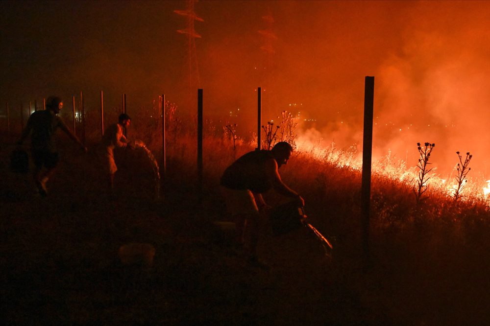
Dangerous smoke from large wildfires burning in Canada and Minnesota is expected to blanket wide portions of the Midwest and Northeast United States this week, putting millions of people at risk from hazardous air pollution.
Minnesota officials have issued an air quality alert running from Tuesday through Friday for several areas, including the Twin Cities metro area, Alexandria, and Two Harbors. The northeastern corner of the state is expected to see especially heavy smoke as the fires continue to grow. Air quality in Two Harbors, the Tribal Nation of Grand Portage, and other parts of northeastern Minnesota is forecast to reach hazardous levels — conditions considered unsafe for everyone, not just those with health vulnerabilities.
Dan Westervelt, an associate professor at Columbia University’s Climate School, described the situation as “a perfect storm for really dry conditions to provide a lot of fuel for these wildfires to burn.” He noted that severe drought combined with intense heat across Canada and the U.S. has created ideal conditions for fire spread. Scientific research indicates that rising temperatures driven by the burning of coal, oil, and gas are making wildfires both more frequent and more destructive.
Tyler Hasenstein, a meteorologist with the National Weather Service in Chanhassen, Minnesota, is advising people to stay inside as much as possible to avoid both the extreme heat and the incoming smoke. “Those two things coinciding with each other is not good from a health perspective,” he warned.
Officials in Michigan and Wisconsin also cautioned residents Tuesday that air quality problems could persist for several days. Fine particulate matter carried by wildfire smoke poses the greatest danger to sensitive populations, including children and individuals with heart or lung conditions.
In parts of Maine, residents reported an unusual yellowish and brownish tint to the sky. The National Weather Service office in Gray, Maine, posted on social media Tuesday that “there is plenty of smoke upstream, so expect periods of hazy skies over the next day before the cold front pushes through.”
According to Hasenstein, by Wednesday afternoon the heaviest smoke will push into the East Coast and Midwest, affecting areas including parts of the New England coastline, northern Pennsylvania, Detroit, and Milwaukee. Several counties in western and central New York were placed under an air quality advisory Wednesday lasting until midnight. Hasenstein added that the most intense smoke could push as far south as Washington, D.C. by midday Thursday.
Breathing in fine particle pollution from wildfire smoke can trigger shortness of breath, coughing, dizziness, and fatigue, while also worsening existing heart and lung diseases and other long-term health conditions. Health experts recommend cutting back or canceling outdoor activities, wearing an N95 mask when going outside is unavoidable, and keeping indoor air clean by shutting windows and running an air purifier or air conditioner. Over the long term, repeated exposure to fine particulate matter from wildfire smoke is recognized as one of the leading contributors to premature death.
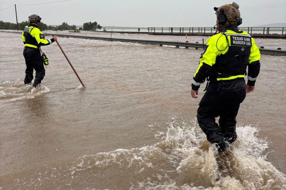
Powerful rainstorms slammed South Texas on Tuesday, flooding highways and leaving motorists stranded as weather forecasters cautioned that additional rounds of severe weather could trigger dangerous flooding in already waterlogged counties along the Mexican border.
Some rural parts of Texas received up to 12 inches of rain, sparking dozens of high-water rescues throughout the region. Officials were forced to close sections of a heavily traveled highway near Uvalde — located roughly 80 miles west of San Antonio — for several hours. A flood watch was also extended to Kerr County, the same area where devastating flooding along the Guadalupe River claimed more than 100 lives last year.
As of Tuesday, no fatalities or injuries had been reported.
The National Weather Service cautioned that overnight storms could drop an additional foot or more of rain in certain locations through Wednesday, raising the risk of catastrophic flash flooding west of San Antonio. Texas Gov. Greg Abbott declared a disaster in dozens of counties in response to the threat.
“Intense rain rates and compounding effects from multiple rounds of storms will result in a dangerous flash flooding threat through Thursday,” the National Weather Service stated.
Rescue teams were captured on video navigating flooded streets by boat, and footage showed at least one vehicle being carried away by rapidly moving floodwaters. According to Maggie Berger, a spokesperson for the Texas Parks and Wildlife Department, five people were pulled to safety by the Texas Game Warden Search and Rescue Team, while a local game warden rescued four additional individuals.
In Uvalde, local officials reported at least two dozen water rescues had taken place. A local event center was opened to provide shelter for residents displaced by the flooding.
The National Weather Service office in Mount Holly, New Jersey has put a Heat Advisory into effect, beginning Monday, July 14th at 4:54 PM Eastern Time and lasting through Tuesday, July 15th at 8:00 PM Eastern Time.
Residents are urged to take the necessary steps to stay safe during periods of elevated heat and humidity. Health officials generally recommend drinking plenty of water, staying in air-conditioned spaces when possible, and avoiding strenuous outdoor activity during the hottest parts of the day.
Those most at risk during heat events include the elderly, young children, and individuals with certain medical conditions. Neighbors are encouraged to check on one another, particularly those who may not have access to air conditioning.
Stay with TV Delmarva for any updates to this advisory as conditions develop.
An Extreme Heat Warning has been issued by the National Weather Service out of Mount Holly, New Jersey, beginning Monday, July 14 at 4:54 PM Eastern Time and continuing through Tuesday, July 15 at 8:00 PM Eastern Time.
Extreme Heat Warnings are issued when dangerously high temperatures and heat index values are expected to pose a significant risk to public health. Residents should take steps to stay cool, stay hydrated, and check on vulnerable neighbors, elderly family members, and young children during the warning period.
If you do not have access to air conditioning, local cooling centers may be available in your area. Avoid strenuous outdoor activity during the hottest parts of the day, and never leave people or pets unattended in parked vehicles.
Stay with TV Delmarva for the latest updates on this Extreme Heat Warning and any changes to the forecast.
The National Weather Service office located in Mount Holly, New Jersey has issued an Air Quality Alert, according to an official advisory released on July 14 at 3:45 PM Eastern Time.
Residents in the affected area are encouraged to be mindful of outdoor activities during the alert period, particularly those who may be sensitive to air quality conditions, such as children, the elderly, and individuals with respiratory conditions like asthma.
When air quality alerts are in effect, health officials generally recommend limiting prolonged outdoor exertion and staying indoors when possible. Those who must be outside should take appropriate precautions.
Residents should monitor updates from the National Weather Service and local health authorities for the latest information on air quality conditions and when the alert is expected to expire.
The National Weather Service office located in Mount Holly, New Jersey has issued an Air Quality Alert, according to an official government weather notification.
The alert was issued on July 14 and signals that air quality conditions in the affected region may pose health concerns for some residents, particularly those with respiratory conditions or other sensitivities.
Residents are encouraged to limit prolonged outdoor activity, especially strenuous exercise, until the alert has been lifted. Those with asthma, heart disease, or other respiratory conditions should take extra precautions and consider staying indoors.
For the latest information on the duration and specific areas covered by this alert, residents should monitor updates from the National Weather Service.
The National Weather Service office located in Mount Holly, New Jersey has issued an Air Quality Alert for the local region.
Details regarding the specific pollutants, affected counties, and the duration of the alert were not included in the available information. Residents are encouraged to check with local authorities or the NWS for the full scope of the advisory.
During air quality alerts, health officials typically recommend that sensitive groups — including the elderly, children, and those with respiratory or heart conditions — reduce prolonged outdoor exertion. Even healthy individuals may want to consider limiting strenuous outdoor activities until the alert is lifted.
Stay with TV Delmarva for updates as more information becomes available.
A Heat Advisory has been issued by the National Weather Service office in Mount Holly, New Jersey, beginning Monday, July 14 and lasting through Tuesday, July 15 at 8:00 PM Eastern Daylight Time.
During a Heat Advisory, conditions are expected to be hot and potentially dangerous, particularly for vulnerable populations including the elderly, young children, and those with certain medical conditions. Residents are urged to drink plenty of water, avoid strenuous outdoor activity during the hottest parts of the day, and seek air-conditioned spaces when possible.
If you do not have access to air conditioning at home, consider visiting a public cooling center such as a library or community center. Never leave children or pets unattended in parked vehicles, even briefly, as temperatures inside a vehicle can rise to life-threatening levels within minutes.
Check on elderly neighbors, friends, and family members during this advisory period to make sure they are staying cool and safe.
An Extreme Heat Warning has been issued by the National Weather Service out of Mount Holly, New Jersey, signaling a dangerous stretch of hot weather for the area.
The warning went into effect on Monday, July 14 at 3:06 PM Eastern Time and is set to expire on Tuesday, July 15 at 8:00 PM Eastern Time.
Extreme Heat Warnings are issued when conditions are expected to be life-threatening. Residents should take steps to stay cool, stay hydrated, and check on vulnerable neighbors, the elderly, and young children during the duration of this warning.
If you do not have air conditioning at home, local cooling centers may be available in your area. Avoid strenuous outdoor activity during the hottest parts of the day, and never leave people or pets in parked vehicles.
Sussex County officials are once again opening their doors to residents seeking relief from the heat, as another dangerous stretch of hot weather is set to move into the area.
On Tuesday, July 14, county officials announced that a number of facilities will serve as designated cooling stations through Friday, July 17. The National Weather Service has issued a heat advisory for Sussex County that remains in effect until 8 p.m. Wednesday, July 15. During that time, temperatures are expected to climb toward 100 degrees, with humidity making it feel as hot as nearly 110 degrees. While this heat event is not expected to be as severe as what hit the region over the July Fourth weekend, it is still considered dangerous. Some relief may arrive by the weekend, when scattered showers and thunderstorms could bring temperatures back down into the low 90s.
Air-conditioned county facilities are open to the public during regular business hours. Those locations include:
County Admin Building 2 The Circle, Georgetown, DE 8:30 a.m.–4:30 p.m., Monday through Friday
South Coastal Library 43 Kent Ave., Bethany Beach, DE Monday, Tuesday: 10 a.m.–6 p.m.; Wednesday, Thursday: 10 a.m.–7 p.m.; Friday: 10 a.m.–5 p.m.; Saturday: 10 a.m.–3 p.m.
In addition to these county sites, 11 independent community libraries throughout the area are also available as cooling stations during their normal hours of operation.
The State of Delaware has also opened cooling stations at select state buildings. For more information on those locations, residents can call 2-1-1 or visit the State’s website.
Sussex County paramedics will make periodic visits to county cooling station locations, as their schedules allow, to answer any heat-related questions or concerns. Free individual bottles of water will also be provided to visitors. Anyone stopping by a cooling station is encouraged to bring any medications or specialty items they may need.
A map of all designated cooling stations in Sussex County is available at https://tinyurl.com/bde2v3mv. For the latest updates on cooling station availability, residents can call (302) 855-1969.
Officials are urging everyone to stay indoors as much as possible, particularly during the peak heat hours of approximately 1 p.m. to 6 p.m. Those who do need to go outside should take frequent breaks and drink plenty of water.
Hot Weather Safety Tips:
Wear lightweight, light-colored clothing, as lighter fabrics reflect sunlight rather than absorbing heat the way dark materials do. Stay in well-ventilated spaces and avoid heavy physical activity during the hottest part of the day. Drink plenty of water and avoid alcoholic beverages.
It is important to recognize the warning signs of heat-related illness. Heat cramps can cause muscle pain and spasms following physical exertion. Moving to a cooler area, gently stretching the muscle, and sipping water can help. Heat exhaustion and heat stroke are far more serious conditions. Heat exhaustion may present as a pale or flushed appearance, headache, or nausea. Heat stroke symptoms include a rapidly rising body temperature, loss of consciousness, a rapid or weak pulse, and quick, shallow breathing. Seek immediate medical attention if heat stroke is suspected.
Residents are also reminded to check in on elderly neighbors, friends, and family members, as well as young children, who may be especially vulnerable to extreme heat. Don’t forget pets — make sure they have extra water, access to shade, or a cool indoor space.
Conserving Electricity During the Heat Wave:
With temperatures and humidity expected to spike over the coming days, power demand will rise significantly. Sussex County Emergency Management is asking all residents and businesses to help prevent outages by reducing electricity use where possible.
Homeowners can help by setting air conditioners to 80 degrees or using fans as an alternative, and by minimizing how often refrigerators and freezers are opened. Turning off non-essential lights and appliances, and waiting until after 8 p.m. to run high-energy devices like washing machines and dryers, can also make a difference. Preparing lighter meals that don’t require heavy cooking — or using an outdoor grill or microwave instead of an electric range — is another helpful step. Keeping window shades, blinds, or curtains closed during the hottest part of the day will help block heat from entering the home. Moving lamps, televisions, and other heat-generating items away from air conditioner thermostats can prevent the system from running longer than necessary. Clearing furniture and other objects from in front of central air conditioning vents will allow cool air to flow more freely through rooms.
Businesses can also do their part by raising thermostat settings and switching off any lighting or equipment that is not in use.
Sussex County is also encouraging residents to take advantage of the county’s free Smart911 service by creating a Safety Profile for their household. These profiles can include details about a property, any special medical needs, and family contacts — information that could be critical for first responders during an emergency. Profiles can be created at www.smart911.com.
Sussex County Emergency Management will continue tracking conditions and will provide updates as needed. For the latest information, follow the county’s emergency management pages on Facebook at www.facebook.com/SussexCountyPublicSafety and on X at www.x.com/SussexCtyDE_EM.
Delaware health officials are stepping in to help residents cope with a stretch of dangerous heat hitting the First State this week. The Delaware Department of Health and Social Services (DHSS) has announced it will open cooling centers beginning Wednesday, July 15 and running through Friday, July 17, as temperatures are expected to exceed 90 degrees for multiple consecutive days.
The cooling centers will be open each day from 8:30 a.m. to 4:30 p.m., giving residents a place to find relief during the hottest parts of the day. The announcement was made from New Castle ahead of the anticipated heat event.
Officials are encouraging anyone who needs a break from the heat — particularly those without air conditioning at home — to take advantage of the available locations during this period of extreme temperatures.
A test tsunami warning was issued by the National Weather Service National Tsunami Warning Center on July 14, active from 12:33 PM EDT through 1:33 PM EDT.
This was a test alert only, and no actual tsunami danger existed during this period. The warning was issued and expired within a one-hour window.
Dangerous heat and humidity will build across the Mid-Atlantic on Wednesday, July 15, and remain a concern into Thursday, July 16. Residents are being urged to prepare now and limit their exposure during the hottest portion of the day.
While high temperatures will be a major part of this heat wave, the combination of heat, humidity, direct sunlight and physical activity will create the greatest danger. Heat-related illnesses can develop quickly when the body is unable to cool itself properly.
Anyone can become sick from excessive heat, but older adults, infants, young children, pregnant women, outdoor workers and people with chronic health conditions face a greater risk. Hot weather can also worsen existing heart, lung and other medical conditions.
Prepare Before the Heat Arrives
Residents should complete outdoor chores, errands and other preparations before the worst heat develops Wednesday afternoon.
Check that air-conditioning systems and fans are working properly. Close curtains or blinds that receive direct sunlight and identify an air-conditioned location where you can go if your home becomes too hot.
People without reliable air conditioning should plan to visit a cooling center, library, shopping center, community building or the home of a friend or relative. During extreme heat, fans should not be relied upon as the only source of cooling inside a very hot building.
Residents should also check on older relatives, neighbors and anyone who lives alone. A phone call may not be enough. When possible, confirm that the person’s home is cool and that they have access to water, medication and transportation to an air-conditioned location.
Drink Water Before You Feel Thirsty
Begin hydrating before spending time outside and continue drinking water regularly throughout the day. Do not wait until you feel thirsty.
People performing physical work should take frequent water and rest breaks. Outdoor workers may need to reduce their workload, rotate assignments or move strenuous tasks into the early morning. The National Institute for Occupational Safety and Health recommends frequent water intake and periodic rest breaks for people working in hot environments.
Alcohol should be limited because it can contribute to dehydration. Heavy meals and excessive caffeine may also make some people feel worse during very hot conditions.
Anyone whose doctor has restricted their fluid intake should speak with a medical professional about how to remain safe during the heat wave.
Avoid the Hottest Part of the Day
The greatest heat stress will generally occur during the afternoon and early evening. Yard work, exercise, construction projects and other strenuous activities should be moved to the early morning whenever possible.
People who must remain outside should take frequent breaks in shade or air conditioning. Wear lightweight, loose-fitting and light-colored clothing, along with a hat and sunscreen.
Direct sunlight can make conditions feel significantly hotter than temperatures measured in the shade. Pavement, rooftops, athletic fields and other exposed surfaces can become especially dangerous during the afternoon.
Never ignore dizziness, weakness or nausea in order to finish a job, practice or outdoor event. Stop the activity immediately and move to a cooler location.
Never Leave Anyone in a Parked Vehicle
Never leave a child, older adult, person with a disability or pet inside a parked vehicle, even for a few minutes.
Cracking the windows or parking in the shade does not make a vehicle safe. Before locking your vehicle, check the front and back seats every time.
Parked vehicles should also remain locked when unattended so children cannot climb inside and become trapped.
Protect Pets
Keep pets indoors during the hottest portion of Wednesday and Thursday whenever possible. Outdoor animals must have continuous access to fresh water and full shade.
Limit walks to the early morning or later evening. Asphalt and concrete can become hot enough to burn an animal’s paws.
Never leave a pet inside a parked vehicle, even with the air conditioning running or the windows partially open.
Use Extra Caution With Medication
Certain medications may affect the body’s ability to regulate temperature, sweat or remain hydrated. People taking prescription medications should review their personal heat risk with a doctor or pharmacist.
Do not stop or change medication without medical guidance. The Centers for Disease Control and Prevention recommends developing a personal heat-action plan with a healthcare provider when medications or chronic health conditions may increase heat sensitivity.
Medication should also be stored according to its instructions and should not be left inside a hot vehicle.
Recognize Heat Exhaustion
Heat exhaustion is a warning that the body is struggling to handle the heat. Symptoms can include:
Heavy sweating
Dizziness or faintness
Headache
Nausea
Weakness or fatigue
Muscle cramps
Cool or clammy skin
A rapid pulse
Move the person into air conditioning or shade immediately. Loosen or remove unnecessary clothing, apply cool wet cloths and offer small sips of cool water.
Do not allow the person to return to strenuous activity. Seek medical help if symptoms worsen, vomiting occurs or the person does not begin improving.
Heat Stroke Is a Medical Emergency
Heat stroke can cause permanent injury or death and requires immediate emergency treatment.
Warning signs can include:
Confusion or unusual behavior
Slurred speech
Loss of consciousness
Hot or flushed skin
Seizures
A very high body temperature
A rapid, strong pulse
Call 911 immediately if heat stroke is suspected. Move the person into a cooler area, remove excess clothing and begin rapid cooling with cold water, wet cloths or ice while waiting for emergency responders.
Do not give fluids to an unconscious or confused person. Delayed treatment can be fatal.
Take the Heat Seriously
Heat-related illness is preventable, but only when precautions are taken before symptoms begin.
Remain hydrated, reduce outdoor activity, seek air conditioning and check on vulnerable family members and neighbors throughout Wednesday and Thursday. Anyone experiencing signs of heat illness should stop what they are doing and move into a cooler environment immediately.
This is not the type of heat to push through. Taking a break, changing outdoor plans or seeking an air-conditioned location could prevent a medical emergency.
A stretch of above-normal temperatures begins today across the Mid-Atlantic and will continue through the end of the week, with Wednesday expected to be the hottest and most dangerous day. Extreme Heat Warnings and Heat Advisories are in effect across the region as temperatures and humidity climb.
An expanding area of high pressure over the central United States is building eastward toward the East Coast. At the same time, low pressure moving through eastern Canada will strengthen the flow of hot air into the region through Wednesday.
High temperatures today will range from the upper 80s to the mid-90s. Humidity will remain somewhat manageable, keeping most locations below dangerous heat thresholds. Heat index values could still reach the middle and upper 90s, especially from the Philadelphia area northward.
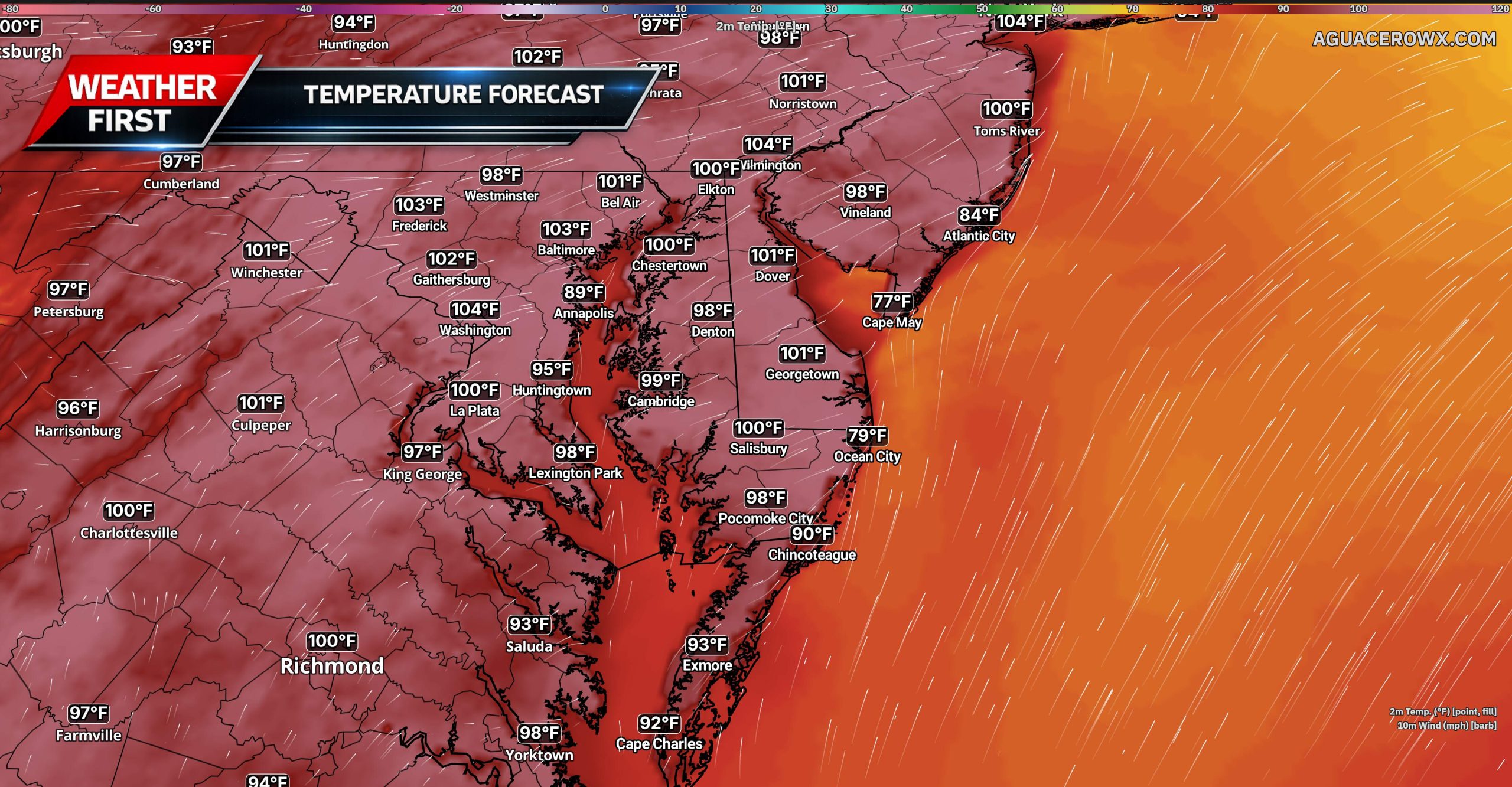
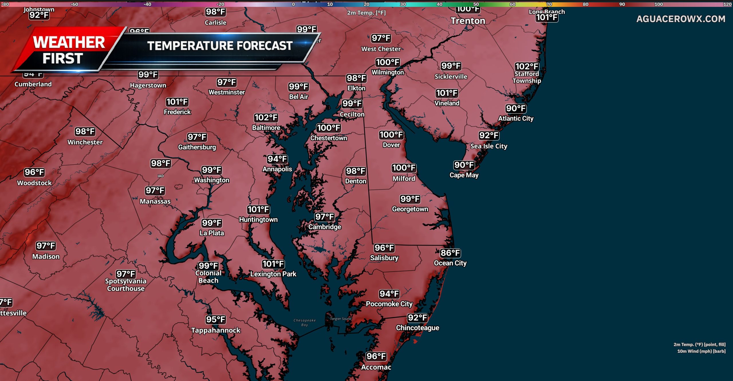
Conditions will become significantly hotter and more humid on Wednesday. High temperatures are expected to reach the middle and upper 90s, with some locations approaching or briefly reaching 100 degrees. The hottest conditions are expected along and southeast of Interstate 95, including much of Delaware, southern New Jersey and Maryland’s Eastern Shore.
Heat index values Wednesday afternoon are forecast to range from 100 to 109 degrees across much of the region. A westerly wind of 10 to 15 mph will likely prevent the sea breeze from moving very far inland, allowing temperatures at the Delaware and New Jersey beaches to climb into the middle and upper 90s. Heat index values near the coast could still reach 100 to 105 degrees.
Residents should limit strenuous outdoor activity, drink plenty of water and take frequent breaks in air-conditioned locations. Children and pets should never be left inside parked vehicles, even for a short period of time.
A mostly dry cold front is expected to move through the region late Wednesday. A few isolated thunderstorms could develop along the front, mainly across the Lehigh Valley, Poconos and northern New Jersey. Most of Delmarva is expected to remain dry.
The front will provide only limited relief. Thursday will remain hot, with highs in the upper 80s and 90s and heat index values potentially reaching the upper 90s to around 100 degrees along and southeast of Interstate 95. Additional Heat Advisories may be needed across southern portions of the region.
Friday should bring lower humidity as drier air moves southward, although temperatures may remain in the lower and middle 90s. Above-normal temperatures could continue into the weekend, even as the worst of the humidity temporarily eases.
The National Weather Service office in Mount Holly, New Jersey has issued a Heat Advisory covering the area, effective starting at 2:38 AM EDT on Monday, July 14, and lasting through 8:00 PM EDT on Tuesday, July 15.
Residents are urged to take the heat seriously during this advisory period. Heat advisories are issued when conditions are expected to cause significant discomfort and may pose health risks, particularly for vulnerable populations such as the elderly, young children, and those with certain medical conditions.
Authorities typically recommend staying hydrated, limiting time outdoors during the hottest parts of the day, and checking on neighbors and family members who may be at greater risk. If you do not have access to air conditioning, consider visiting a public cooling center during the advisory period.
The National Weather Service office in Mount Holly, New Jersey has issued an Extreme Heat Warning for the area, beginning at 2:38 AM EDT on Monday, July 14, and running through 8:00 PM EDT on Tuesday, July 15.
An Extreme Heat Warning is the highest-level alert issued by the National Weather Service for dangerous heat conditions. It indicates that very high temperatures or a combination of heat and humidity could be life-threatening for those without access to cooling.
Residents are strongly encouraged to stay indoors in air-conditioned spaces during the hottest parts of the day, drink plenty of water, and check on elderly neighbors, young children, and those with health conditions who may be especially vulnerable to extreme heat.
If you do not have air conditioning at home, consider visiting a public cooling center, library, or shopping center to escape the heat. Never leave children or pets unattended in parked vehicles.
For the latest updates and safety information, monitor your local forecast from the National Weather Service.
The National Weather Service office in Mount Holly, New Jersey has issued a Heat Advisory that went into effect at 2:38 AM Eastern Time on July 14th and is set to remain in place until 8:00 PM Eastern Time on July 15th.
During a Heat Advisory, dangerously warm conditions are expected that can pose serious health risks, particularly for the elderly, young children, and those with certain medical conditions. Residents are encouraged to drink plenty of water, stay in air-conditioned spaces when possible, and avoid strenuous outdoor activity during the hottest parts of the day.
Officials also recommend checking in on neighbors, friends, and family members who may be especially vulnerable to heat-related illness. Never leave children or pets unattended in parked vehicles, as temperatures inside can rise rapidly to life-threatening levels.
If you or someone you know experiences symptoms of heat exhaustion or heat stroke — such as heavy sweating, dizziness, nausea, or confusion — seek medical attention immediately.
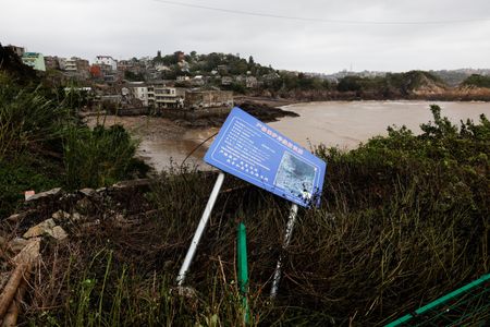
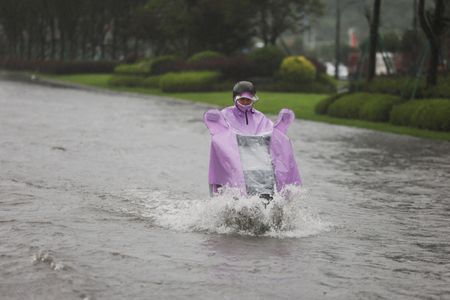
More than 260,000 people have been forced from their homes in northeastern China’s Liaoning province as Typhoon Bavi — the most powerful storm to strike mainland China this year — unleashed intense flooding across the region.
Authorities warned that heavy rain is expected to continue through Tuesday, with some areas facing extreme downpours. The storm is pulling large amounts of tropical moisture northward, creating a sustained flow of humid air into northern China.
In Shenyang, the provincial capital of Liaoning, the flooding reached dramatic levels. Videos circulating on Chinese social media showed a lighthouse that had snapped its high-voltage power line and was drifting through floodwaters along major roads, eventually passing under a bridge.
Officials have ordered all schools and training institutions to suspend classes. Transportation services have been largely shut down across several northeastern cities, including Shenyang and Jilin.
Bavi originated in the Pacific Ocean 13 days ago and spans an area roughly the size of France. Remarkably, the storm’s structure remained mostly intact on Monday, even after making landfall along China’s eastern coast on Saturday night — making it the longest-lasting tropical cyclone in the Asia-Pacific region so far this year.
Chinese meteorologists attribute the storm’s endurance to its unusually well-preserved warm core, which has allowed Bavi to hold onto much of its moisture as it moves northward toward the Korean peninsula. Currently classified as a tropical storm, Bavi is expected to unleash its heaviest rainfall once it slows down and begins releasing the moisture it has been carrying.
Drivers traveling southbound on Route 1 between Cave Neck Road and Minos Conaway Road are facing a right lane closure that is scheduled to last until 7 AM.
Motorists in the area should anticipate potential slowdowns and allow extra travel time. Drivers are encouraged to consider alternate routes if possible until the lane reopens.
Another brutal week of dangerous heat is bearing down on the United States, and this time the nights aren’t offering much of a break either.
The National Weather Service is forecasting that more than 90 temperature records across the country could be tied or shattered by Wednesday — and the majority of those records are expected to fall overnight, not during the day.
Health professionals warn that high nighttime temperatures are actually more hazardous than scorching daytime highs, because the body never gets the chance to recover.
A long-lasting heat dome has been smothering much of the country, making this one of the hottest starts to summer in recent memory. The extreme temperatures in recent weeks have already been linked to heat-related deaths in New Jersey and have contributed to wildfire activity in the West.
In cities like Fort Lauderdale, Florida; Miami; Tampa, Florida; Galveston, Texas; and Charleston, South Carolina, nighttime temperatures are not expected to dip below 80 degrees Fahrenheit (27 C), according to the National Weather Service.
Even areas of the Midwest and Northeast more commonly associated with harsh winters will see nighttime temperatures stay above 70 degrees Fahrenheit (21 C) over the next several days — including Fargo, North Dakota; International Falls, Minnesota; and Portland, Maine.
The reason overnight heat is so dangerous comes down to basic biology: when temperatures stay high through the night, the body’s core temperature never gets a chance to cool down and reset from the strain of the day.
“That’s where the health outcomes are amplified, particularly for the elderly and vulnerable communities,” explained University of Georgia meteorology professor Marshall Shepherd.
Even a small rise in core body temperature can trigger heatstroke or put dangerous levels of stress on the heart.
Kristie Ebi, a public health and climate scientist at the University of Washington, noted that when nighttime temperatures fail to bring relief, the health consequences often don’t show up until the following day. “Mortality starts the second or third day” because the body is simply unable to cool itself down, she said Monday.
Early warning signs of heat illness include heavy sweating, muscle cramps, and headaches. “It’s hard to know you’re getting in trouble with the heat. This is why we need to be more proactive,” Ebi said.
Cooling down is essential — whether that means stepping into an air-conditioned space or simply wrapping a cold, wet towel around your neck.
Health experts are also urging people to check in on friends and family, particularly those who are elderly, pregnant, or dealing with health conditions that make it harder to cope with extreme heat.
Even for those without air conditioning at home, options are available. Heading to a library or a shopping mall can provide relief. Sitting in front of a fan while misting your skin with water, soaking your feet in cold water, wetting your clothing, and staying well-hydrated are all practical steps that can make a real difference.
A Heat Advisory has been issued by the National Weather Service out of Mount Holly, New Jersey, beginning Sunday, July 13 at 2:45 PM Eastern Time and lasting through Tuesday, July 15 at 8:00 PM Eastern Time.
During a Heat Advisory, conditions are expected to be hot enough to pose a risk to health, particularly for vulnerable individuals such as the elderly, young children, and those with certain medical conditions.
Residents are encouraged to drink plenty of water, stay in air-conditioned spaces when possible, and check on neighbors and loved ones who may be at greater risk. Avoid strenuous outdoor activity during the peak afternoon hours when temperatures are at their highest.
The advisory remains in effect until Tuesday evening. Stay with TV Delmarva for the latest updates on this heat event.
The National Weather Service office in Mount Holly, New Jersey has issued an Extreme Heat Watch, warning residents of potentially dangerous heat conditions expected to develop in the coming days.
The watch took effect Sunday, July 13 at 2:45 PM Eastern Time and is set to remain in place through Tuesday, July 15 at 8:00 PM Eastern Time.
An Extreme Heat Watch means that conditions are favorable for a dangerous heat event to occur. Residents are urged to take precautions, stay hydrated, limit time outdoors during peak afternoon hours, and check on elderly neighbors and family members who may be more vulnerable to extreme heat.
Additional details and updates are expected as the event approaches. Stay tuned to TV Delmarva for the latest forecast information and any changes to this watch.
Another stretch of dangerous summer heat is expected to build across the Mid-Atlantic this week, with temperatures climbing above normal beginning Tuesday and potentially remaining elevated through the weekend.
A strengthening ridge of high pressure will extend into the region from the west while surface high pressure moves offshore. This setup will produce a warm south to southwesterly flow, allowing hotter temperatures and increasing humidity to spread across the region.
Tuesday will mark the beginning of the heat wave, with afternoon temperatures rising into the lower and middle 90s across many locations. Conditions will become even hotter Wednesday, July 15, which is expected to be the hottest day of the stretch.
High temperatures Wednesday are forecast to reach the middle and upper 90s, with a few locations potentially approaching 100 degrees. Although humidity levels may not be as extreme as those observed during the early July heat wave, the combination of heat and moisture could still push heat index values between 105 and 108 degrees in the hottest locations.
An Extreme Heat Watch has been issued for the Philadelphia metropolitan area from Wednesday morning through Wednesday evening. The watch includes portions of southeastern Pennsylvania, southern New Jersey and northern Delaware. Additional Heat Advisories or Extreme Heat Warnings may be issued for surrounding areas as the event draws closer.
The most dangerous conditions are expected along the Interstate 95 urban corridor, where the urban heat island effect can keep temperatures especially high during the afternoon and slow overnight cooling. However, dangerous heat will also be possible across surrounding communities, including portions of the Delmarva Peninsula.
Several daily record highs could be approached Wednesday. The current record for July 15 at Georgetown, Delaware, is 96 degrees, while Wilmington’s record is 99 degrees. Philadelphia’s record of 103 degrees is less likely to be reached, but temperatures could once again approach the century mark in and around the city.
A weak and mostly dry cold front is expected to pass through the region late Wednesday. This should lower temperatures slightly, but significant relief is not anticipated. Afternoon highs may remain in the upper 80s and lower 90s Thursday through the end of the week, with above-normal temperatures potentially continuing into the weekend.
Anyone spending time outside should take the developing heat seriously. Drink plenty of water, limit strenuous outdoor activities during the hottest part of the day and take frequent breaks in air-conditioned locations. Children, older adults, outdoor workers and anyone without reliable access to cooling will face the greatest risk for heat-related illness.
Never leave children or pets inside a parked vehicle, even for a brief period. Residents should continue monitoring forecast updates because additional heat alerts will likely be issued before temperatures peak Wednesday.
The National Weather Service office in Mount Holly, New Jersey has issued an Extreme Heat Watch beginning early Sunday morning, July 13, and lasting through Tuesday evening, July 15 at 8:00 PM Eastern Time.
A Heat Watch means that conditions are favorable for an extreme heat event to develop in the area. Residents are encouraged to stay cool, stay hydrated, and check on vulnerable neighbors, the elderly, and young children during this period.
Officials urge people to limit time outdoors during the hottest parts of the day, never leave children or pets in parked vehicles, and seek air-conditioned spaces if possible. Local cooling centers may be available for those without access to air conditioning.
Stay with TV Delmarva for the latest updates on this developing weather situation as the National Weather Service continues to monitor conditions through the week.
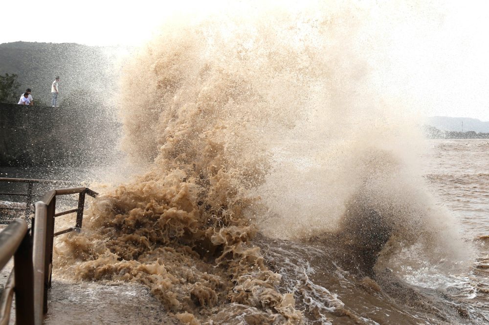
Powerful flooding has overwhelmed communities in northern China, with roads completely submerged and vehicles swept away by raging floodwaters in Hebei and Liaoning provinces, according to videos circulating on social media.
In Kuancheng, a county in Hebei province home to roughly 240,000 residents, water rose to heights exceeding two meters on local roads, according to an account from a local resident that was broadcast by official local media. The county sits along the banks of the Luan River.
Social media footage captured multiple cars colliding with one another as they were tossed around on a flooded street in Kuancheng before being carried off entirely by the powerful current.
The disaster followed in the wake of Typhoon Bavi, described as the strongest storm to hit mainland China so far this year. The typhoon brought intense rainfall to the eastern coastline and fierce winds to densely packed urban areas, pushing the country’s emergency response systems to their limits.
Officials issued warnings that the storm would unleash torrential downpours across the provinces of Jilin, Liaoning, Hebei, Shandong, Jiangsu, and Anhui — compounding flood dangers in regions already saturated from earlier storms.
State broadcaster CCTV reported that approximately 1,800 villagers in Kuancheng found themselves stranded, with authorities declaring that moving and sheltering affected residents was the highest priority. In Liaoning, officials elevated the flood alert to red — the most severe level — citing extremely high risks of flash flooding.
Hebei authorities posted a warning on WeChat stating: “During a red alert for heavy rain, all work stoppages, business closures, and gatherings must be fully implemented.”
Remarkable footage shared on RedNote, a Chinese social media platform also known as Xiaohongshu, showed a person swimming backstroke down a street in Shenyang, Liaoning, where rows of parked cars were nearly fully submerged with only their rooftops visible. Another video from the same platform showed someone navigating the flooded streets while standing on a paddleboard.
China Railway announced Monday that train service in Shenyang has been largely suspended, with more than 30 railway segments impacted by the flooding.
Schools have shut down across multiple regions, including the northeastern province of Jilin.
CCTV, citing the country’s Central Meteorological Observatory, reported that parts of northeastern China could see thunderstorms or hailstorms reaching Force 8 or stronger.
“In some areas of central and northern Jiangsu, thunderstorm winds of level 10 or above will occur, with maximum winds reaching force 11 or above, and tornadoes may occur locally,” the observatory warned. Force 11 winds can reach speeds as high as 117 kilometers per hour, or about 73 miles per hour.
China’s Ministry of Water Resources reported that 46 rivers across the country are currently experiencing water levels above official flood warning thresholds, according to CCTV.
Motorists in the area should be aware that Glenda Road is closed at its intersection with Case Ridge Road due to a tree that has fallen across the roadway.
The closure is expected to remain in place until July 13, 2026, while crews work to address the situation.
Drivers are advised to seek alternate routes and allow extra travel time until the road is reopened.
Minnesota Governor Tim Walz activated state National Guard troops this past Sunday to help fight a series of wildfires burning along the northern edge of the state near the Canadian border.
According to the Minnesota state website, the fires have burned through more than 800 acres over the course of five days and have not yet been brought under control. These blazes are part of a broader wave of wildfires spreading across the United States, fueled by hot and dry weather conditions tied to an El Niño weather pattern affecting the entire continent.
Governor Walz, a Democrat, announced the emergency measure in a statement: “I’ve declared a peacetime emergency and mobilized the National Guard to assist with wildfire response in northern Minnesota. Minnesotans extend our deepest gratitude to all of the first responders working around the clock to keep their neighbors safe.”
Sixteen individual fires are currently burning within the Superior National Forest in northern Minnesota — a popular destination that typically sees around 150,000 visitors during the summer months. The Minnesota Natural Resources Department reported that park rangers spent the weekend escorting visitors safely out of the area.
The National Weather Service noted that elevated temperatures over the weekend added to the already dangerous fire conditions.
Residents across Philadelphia neighborhoods and surrounding counties spent Sunday cleaning up after a string of intense, fast-moving thunderstorms swept through the region the day before, leaving behind a wide swath of destruction.
The storms, classified as microbursts, struck Saturday afternoon and brought down trees and power lines, flooded several streets, and caused structural damage to buildings. In one West Philadelphia neighborhood, a building collapse sent bricks tumbling into the street, crushing parked vehicles and blocking trolley tracks.
The National Weather Service reported that at least four of the microbursts produced straight-line wind gusts ranging from 60 to 70 mph — between 97 and 113 kilometers per hour — across Montgomery and Philadelphia counties. The worst of the storms hit between approximately 2:30 and 3:15 p.m. Saturday. Although some had speculated that a tornado was responsible for the damage — which included part of a roof being ripped from a Philadelphia Housing Authority apartment building — National Weather Service officials confirmed the destruction was caused by straight-line winds, not a tornado.
The Philadelphia-area storms were part of a broader pattern of extreme weather across the United States this weekend, which also included heat waves, flooding, and wildfires in other parts of the country.
Philadelphia Mayor Cherelle Parker said in an early Sunday news release that she personally visited damaged areas across multiple city neighborhoods throughout Saturday afternoon and evening. The city formally issued a Declaration of Disaster Emergency in response to the storms.
“Every level of government is working together today, tonight, and for as long as it takes to respond to this storm, restore services, and help our residents recover. That is our commitment,” Mayor Parker stated.
Philadelphia Housing Authority officials confirmed that 11 residential units were impacted by roof and water damage at the affected apartment building. All residents were safely evacuated and moved to temporary shelter before eventually being transferred to a nearby hotel.
The Philadelphia Office of Emergency Management also assisted with the evacuation of at least one private residence due to storm-related damage, according to city officials.
The National Weather Service out of Mount Holly, New Jersey has put a Coastal Flood Advisory into effect for the evening of July 12, running until 11:00 PM EDT.
The advisory was issued at 4:06 PM EDT, giving coastal residents several hours of notice to prepare for potential minor flooding conditions along low-lying shoreline areas.
During a Coastal Flood Advisory, water levels may rise enough to cause minor flooding in vulnerable spots, particularly near bays, inlets, and low-elevation coastal roads. Residents are encouraged to use caution if traveling near the water and to avoid parking vehicles in areas prone to flooding.
Forecasters with the NWS Mount Holly office are monitoring conditions. Residents should check for updates as the evening progresses and follow any additional guidance from local emergency management officials.
The National Weather Service office in Mount Holly, New Jersey has issued a Coastal Flood Advisory for the local area, effective from 4:06 PM Eastern Time on Saturday, July 12, through midnight on Sunday, July 13.
A Coastal Flood Advisory means that minor flooding is possible in low-lying areas near the coast during times of high tide. Residents are advised to use caution near shorelines and avoid parking vehicles in areas prone to flooding.
Additional details on specific zones and impacts were not provided in the advisory text. TV Delmarva will continue to monitor this situation and provide updates as more information becomes available from the National Weather Service.
Travelers making their way northbound along Coastal Highway should expect some extra time behind the wheel. Congestion along that stretch is currently causing delays of roughly 10 to 15 minutes between Dewey Beach and Lewes.
Drivers in the area are encouraged to factor the slowdown into their travel plans or look for an alternate route to avoid the backup.
A section of Peachtree Run is currently closed to traffic following a downed tree in the area.
The closure affects the stretch of roadway between Sunny Meadow Drive and Fox Hollow Drive. Motorists traveling through the area are advised to find an alternate route until the obstruction is removed and the road is reopened.
No estimated time for the road to reopen has been announced at this time. Drivers should use caution and plan accordingly.
The National Weather Service out of Mount Holly, New Jersey has put a Coastal Flood Advisory into effect for the region, beginning at 4:25 AM EDT on Saturday, July 12, and lasting through 11:00 PM EDT that same evening.
Residents living near the coast or in low-lying areas should take precautions, as minor coastal flooding is possible during this period. Authorities recommend avoiding flood-prone areas and staying alert to changing water conditions throughout the day.
Coastal flood advisories are typically issued when water levels are expected to rise enough to cause minor flooding in vulnerable spots, such as roads near the shoreline, low-lying properties, and tidal areas. While this level of advisory does not indicate a severe or life-threatening situation, it does warrant attention from those in affected zones.
Residents are encouraged to monitor updates from the National Weather Service and local emergency management officials as conditions develop throughout the day on Saturday.
The National Weather Service out of Mount Holly, New Jersey has put a Coastal Flood Advisory into effect, starting at 4:25 in the morning on July 12 and lasting through midnight on July 13.
The advisory signals that minor coastal flooding is possible during this timeframe. Residents living near the shoreline or in low-lying coastal areas are encouraged to take precautions and stay informed as conditions develop.
Coastal flood advisories are typically issued when tidal or storm-driven water has the potential to cause minor flooding in vulnerable areas, such as roads, parking lots, and properties close to the water’s edge.
Locals and beachgoers are urged to monitor the latest updates from the National Weather Service and be cautious around coastal zones until the advisory expires at midnight.
BEIJING (AP) — Typhoon Bavi came ashore in China’s eastern Zhejiang province before losing some of its punch, but the storm was still battering eastern China with dangerous winds and heavy rainfall throughout Sunday.
China’s national weather center reported that by early Sunday morning, the storm had weakened with maximum sustained winds of roughly 101 kilometers per hour — about 63 miles per hour — near its center. Forecasters expect the storm to continue tracking in a northwestward direction across eastern China.
Before reaching the Chinese mainland, Bavi passed to the north of Taiwan on Saturday without making a direct hit. Even so, the storm left its mark — Taiwan’s fire department reported that at least 134 people across the island had been injured as of 7 a.m. Sunday. Many of those hurt were motorcycle or bicycle riders caught in strong gusts, while others were injured on slick road surfaces.
China’s National Meteorological Center warned that numerous eastern Chinese cities should expect strong winds and heavy rain to continue throughout Sunday.
The scale of evacuations was massive. Authorities in Zhejiang province moved approximately 2.2 million residents out of harm’s way, while Shanghai relocated more than 290,000 people from vulnerable areas, according to state media. Fujian province also evacuated more than 180,000 residents.
Air travel took a major hit as well. The official Xinhua News Agency reported that Shanghai’s Pudong International Airport and Hongqiao International Airport were expected to cancel roughly 653 arriving and departing flights because of the typhoon.
In the coastal city of Yueqing, located in Zhejiang province, state broadcaster CCTV reported that more than 1,300 trees were knocked down, with at least 700 of them completely uprooted by the storm’s fury.
Emergency crews armed with excavators and chainsaws spent Sunday clearing streets packed with fallen trees along China’s eastern coast, working in the wake of Typhoon Bavi — the most powerful storm to hit the country this year.
Bavi had weakened to a tropical storm by Sunday morning as it moved inland, but weather forecasters cautioned that the massive storm system — roughly the size of France — could bring prolonged, heavy rainfall across large portions of eastern and northern China. The storm had also triggered at least one landslide and left several areas underwater.
Ahead of the storm’s arrival, close to 2 million people were evacuated, most of them from Zhejiang province, a major hub for technology and economic activity in the world’s second-largest economy.
Bavi first came ashore near the coastal city of Yuhuan in Zhejiang at approximately 11:20 p.m. Saturday local time before striking again in Yueqing, part of the major city of Wenzhou, around midnight.
State broadcaster CCTV reported that more than 1,300 trees toppled across Yueqing, with over 700 of them pulled out by the roots entirely. Floodwaters in some spots reached a depth of roughly half the height of a vehicle tire.
Video footage broadcast by CCTV captured the aftermath of a landslide in the mountainous northern section of the city, where massive boulders rolled down onto a mountain road and nearby trees were swallowed by swollen river waters.
Before reaching mainland China, Bavi tracked north of Taiwan on Saturday, hammering much of the island with fierce winds and heavy rain. One area in the northern county of Miaoli recorded nearly 80 centimeters — about 31 inches — of rainfall.
Taiwan’s fire department announced Sunday that 134 people had been hurt, with most injuries stemming from people falling off motorcycles, slipping, or being struck by flying objects. No fatalities were reported. The island’s transport ministry said 137 international flights and 62 domestic flights were cancelled on Sunday due to the storm.
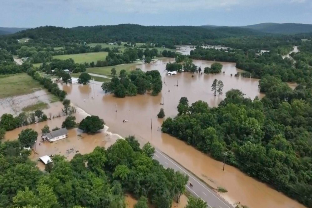
A record-breaking rainfall event has sent floodwaters surging through communities in several Missouri counties, triggering emergency rescues and forcing the evacuation of a summer camp with approximately 200 young campers.
The historic flooding prompted water rescue operations across the affected areas, as rising waters left neighborhoods and communities submerged. Among those who needed help were the hundreds of campers at a summer camp caught in the path of the floodwaters.
Emergency crews worked to carry out rescues as the extreme rainfall overwhelmed the region. The flooding also affected parts of Kentucky, adding to the scope of the disaster across the two states.
The National Weather Service out of Mount Holly, New Jersey has put a Coastal Flood Advisory in place for the region, running from 4:27 PM through 11:00 PM on July 11.
A Coastal Flood Advisory means that minor flooding is possible in low-lying areas near the coast during this period. Residents who live or work near tidal waterways and shoreline areas are encouraged to take precautions and avoid areas prone to flooding.
The advisory is expected to expire late this evening. Forecasters urge the public to stay aware of changing conditions and check for any updates from the National Weather Service as the evening progresses.
A dangerous heat wave is taking shape across the United States, threatening to bring extreme temperatures to a vast portion of the country. Triple-digit highs are expected in the Southwest and Great Plains this weekend, with the heat then pushing eastward beneath a high-pressure dome that weather experts say could lock in oppressive conditions for a week or longer.
Weather forecasters are urging people to drink plenty of water and seek out air-conditioned spaces. Temperatures in many areas are expected to run 15 to 25 degrees Fahrenheit — or 8 to 14 degrees Celsius — above seasonal norms. What makes this event especially dangerous is that the heat won’t let up after sunset, leaving the human body no time to recover overnight.
“The heat doesn’t necessarily stop when it’s dark out,” said Josh Adam, a meteorologist with the National Weather Service in Bismarck, North Dakota. Temperatures there are forecast to exceed 100 F (37 C) through Tuesday — a dramatic departure for a state where summer highs typically hover in the 80s, Adam noted.
The National Weather Service projects that more than 90 local temperature records across the country will be tied or broken by Wednesday. Roughly two-thirds of those records are expected to be overnight heat records. Cities including Fort Lauderdale, Florida; Miami; Tampa, Florida; Galveston, Texas; and Charleston, South Carolina are forecast to see nighttime lows stay above 80 F (27 C).
Chad Merrill, a senior meteorologist with AccuWeather, described the current heat dome as one of the strongest to hit the Dakotas in 25 years. A heat dome forms when high pressure traps hot air in place while blocking the cooling effects of wind and rain.
Record-breaking triple-digit temperatures this weekend are expected across Nevada, Utah, Colorado, Wyoming, Idaho, Montana, North Dakota, and South Dakota.
Andrew Gorelow, a meteorologist with the National Weather Service in Las Vegas, said Nevada — a state no stranger to intense heat — is running even hotter than usual. Las Vegas is forecast to reach 111 F (48 C) on Saturday, Gorelow said.
Experts are stressing that staying hydrated and finding cool environments is essential during this event. They are also cautioning that the extreme heat could elevate wildfire danger in already-dry regions, particularly in the Rockies, where Merrill said dry thunderstorms may develop.
Scientists note that climate change, driven by the burning of coal, oil, and natural gas, is making heat waves more intense, longer-lasting, and more geographically widespread.
This year’s temperatures are also expected to be influenced by El Nino — a natural warming of the equatorial Pacific Ocean that disrupts weather patterns and pushes temperatures higher around the world. The current El Nino formed last month and is considered too new to have significantly contributed to this particular heat wave. However, experts say it has an 81% chance of reaching “very strong” status — the highest category — by fall, according to the U.S. National Oceanic and Atmospheric Administration, which made that announcement Thursday.
Heavy rainfall hammered parts of Missouri on Friday, triggering widespread emergency rescues and evacuations — including a dramatic helicopter airlift of more than 200 children and staff from a summer camp. One person remains unaccounted for as the state continues to deal with the aftermath.
Washed-out roads left Camp Taum Sauk completely cut off in the small southeastern Missouri community of Lesterville, according to Sgt. Eddie Young of the state highway patrol. Army National Guard helicopters — specifically Black Hawks — were deployed to fly the campers and staff to a nearby elementary school, where they were reunited with their families.
The camp expressed its gratitude to emergency crews in a late Friday Instagram post, writing: “We are beyond thankful for your help keeping our camp community safe.”
At a separate location, campers at the Bearcat Getaway campground near the Black River — roughly 85 miles south of St. Louis — had climbed onto a building to escape the rising floodwaters when the structure gave way beneath them. “Between the weight and the constant waters underneath it, it just gave away on them,” Young said.
Three additional people were rescued Friday evening after becoming stranded in trees along the Black River in Reynolds County, Young added.
No major injuries or deaths have been reported, but a woman identified as Faith Gregory has been missing since the house she was in was carried off its foundation by floodwaters in Crawford County, approximately 71 miles southwest of St. Louis. Young confirmed Saturday that Gregory remains the only person still unaccounted for in the county. Family and friends have taken to social media to resume their search and ask others to watch for Gregory and her dogs, who are also believed to have been swept away.
The National Weather Service had issued flash flood warnings for the region as wave after wave of thunderstorms rolled through. Matt Beitscher, a lead meteorologist with the NWS office in St. Louis, noted the area’s vulnerability. “It’s very, very popular place for recreation,” he said. “So there are campgrounds there. There are float trip locations there. A lot of vulnerable populations that would be susceptible to flash flooding.”
Gov. Mike Kehoe declared a state of emergency and activated one of the state’s search and rescue teams. He reported late Friday that hundreds of people had been pulled to safety from floodwaters, trees, rooftops, and stranded vehicles.
Kehoe also warned that the Black River continues to rise and is expected to crest at more than 28 feet near Annapolis in southeastern Missouri — a level that would set a new record for the waterway. Several major roads remain impassable due to flood damage.
“As recovery efforts continue and additional rain is expected, I urge everyone in flood-prone and low-lying areas to stay weather-aware, have multiple ways of receiving alerts, and be ready to take protective action,” Kehoe said in a statement.
In Reynolds County, two rescue boats capsized during the emergency response, though all personnel involved were safely recovered by other responders, according to the sheriff’s office.
The threat is not limited to Missouri. The National Weather Service warned that slow-moving storms are shifting southward and could bring damaging winds, heavy rain, and scattered flash flooding across a broad region stretching from the Ozark Mountains through much of the Ohio and Tennessee river valleys — with some areas facing impacts into Sunday.
Missouri’s Emergency Management Agency cautioned that even as the storms exit the state, additional thunderstorms could still trigger more flash flooding, particularly in areas that have already received between 6 and 12 inches of rain.
Chinese authorities have ordered the evacuation of more than 1.8 million people as Typhoon Bavi churns toward Wenzhou, a major eastern city, after hammering Japan’s southern Sakishima island chain with fierce winds and torrential rain and skirting past northern Taiwan.
Although Bavi has been gradually slowing and losing strength as it travels over cooler ocean waters on a northwesterly track, meteorologists warn the storm remains a serious threat. Its rain bands stretch an area roughly the size of France, carrying an enormous amount of moisture capable of causing widespread flooding.
As of 0808 GMT, the National Meteorological Center reported that Bavi was carrying maximum sustained winds of 144 kilometers per hour — equivalent to a Category 1 hurricane on the Saffir-Simpson scale — and was positioned approximately 200 kilometers southeast of Wenling in the eastern province of Zhejiang. The storm is projected to come ashore near Wenzhou, a city of around 10 million people, in the early hours of Sunday.
State media reported that more than 1.7 million residents had been moved out of harm’s way across Zhejiang province, where Wenzhou is situated, while an additional 100,000 people were evacuated from the neighboring province of Fujian.
Wenzhou resident Huang Xinghuan, 50, was spotted purchasing groceries at a local wet market before it closed ahead of the storm’s arrival. “I’m a little worried, but I think it’ll be OK. We’ve been through typhoons before. We’ll get through it,” he said.
Huang noted that his family had set aside roughly two to three days’ worth of water. He added, “I think supplies are well guaranteed now. There’s no need to panic or stockpile a lot of food or other supplies.”
While neither Japan nor Taiwan has reported any deaths directly from the typhoon, the storm’s influence worsened a southwest monsoon in the Philippines, where 17 people were killed by the resulting heavy rainfall. Taiwan’s fire department reported 87 injuries on the island, most of them involving people falling from motorcycles or bicycles, or being struck by objects.
In Taiwan, the government relocated more than 14,000 residents — primarily from mountainous regions — as the island braced for Bavi’s approach. Though the typhoon did not make direct landfall in Taiwan, officials took extensive precautions given forecasts calling for nearly one meter, or about three feet, of rain in certain areas.
The majority of those evacuated were from northern and eastern parts of the island. Around 920 international flights were cancelled, effectively shutting down the main international airport at Taoyuan, located outside the capital city of Taipei. All 282 domestic flights were also grounded. Nearly every city and county across Taiwan declared a typhoon holiday for Saturday, closing offices and schools, though some restaurants and convenience stores in Taipei remained open. The main north-south high-speed rail line kept running but with reduced service.
In downtown Taipei, some residents ventured outside despite the blustery conditions. “It’s OK, it’s not that serious,” said Yeh Mao-hsiung, 68, who was taking his dog for a morning walk. “It’s just a little bit more wind.”
However, in Taipei’s Beitou neighborhood, nestled in the foothills of the mountains surrounding the city, gusts reaching around 100 kilometers per hour toppled trees and caused rivers to swell.
Back in Wenzhou, a woman in her 60s named Chen Qiuqin was walking through steady rainfall on her way to check on her elderly parents. She said she wanted to help them prepare but wasn’t overly alarmed, citing the government’s response efforts. “I was worried about the flowerpots on my mother’s balcony, so I’m going to help move them inside. My parents are both elderly and they’re home alone, so I wasn’t at ease,” she explained.
The National Weather Service office in Mount Holly, New Jersey has put a Coastal Flood Advisory into effect starting in the early morning hours of Friday, July 11, with the alert set to remain active until 11:00 PM that same evening.
Coastal Flood Advisories are issued when minor flooding is expected in low-lying areas near the shoreline, which can affect roads, properties, and other areas close to the water. Residents in affected coastal communities are encouraged to take precautions and stay aware of changing water conditions throughout the day.
Authorities recommend that people avoid walking or driving through flooded areas and keep an eye on updated forecasts as conditions develop. Check with the National Weather Service for the latest information on which specific areas fall under this advisory.
Typhoon Bavi is already making its presence felt across Japan’s southern islands as Taiwan and eastern China take emergency measures ahead of the storm’s arrival.
The typhoon is packing maximum sustained winds of 144 kilometers per hour (89 miles per hour) near its center. Taiwan’s Central Weather Administration says the storm is projected to pass to the north of Taiwan on Saturday before heading toward Zhejiang province in eastern China. China’s National Meteorological Center expects the typhoon to come ashore in the early morning hours of Sunday.
In Japan’s Okinawa prefecture, local officials have warned residents about dangerous wave heights, powerful winds, and storm surges. More than 200 flights across the region have been scrapped, according to public broadcaster NHK. Islands including Ishigaki have already been hit by strong winds and rain.
By 8 a.m. Saturday, Taiwan’s Central Emergency Operation Center had recorded at least 36 injuries linked to Typhoon Bavi. A significant number of those injuries occurred when people riding motorcycles lost control on rain-slicked roads.
As of Saturday morning, roughly 14,210 residents had been evacuated across Taiwan, with those in the eastern county of Hualien and the central city of Taichung among those displaced. Schools and workplaces in most areas of Taiwan were shut down for the day.
Along China’s southeastern coast, cities are taking precautions ahead of the storm’s expected arrival. In Ningde, a city in Fujian province, more than 3,700 residents were moved away from high-risk coastal areas by Friday evening, according to the state-run Xinhua News Agency. Fujian province authorities have also placed more than 17,000 emergency rescue personnel on standby.
China’s National Meteorological Center has issued an orange typhoon alert — the second-highest level in the country’s four-tier warning system. Schools and ferry services have been suspended in affected areas, with hundreds of flights canceled and some high-speed rail lines halted. On Saturday, the center also issued the year’s first red alert for severe rainstorms, as reported by state broadcaster CCTV.
A fast-moving brush fire erupted Friday afternoon in a thinly populated stretch of Los Angeles County, triggering evacuation orders for residents in the area.
According to the LA County Fire Department, the fire ignited around 1 p.m. in a remote high desert region located about 45 miles (72 kilometers) northeast of Los Angeles. Dangerously dry conditions and extreme heat fueled the blaze, with temperatures in the area climbing to nearly 100 degrees Fahrenheit (38 degrees Celsius).
By Friday evening, the fire had burned through approximately 2,700 acres (1,092 hectares), according to Angeles National Forest officials posting on the social media platform X. The number of structures threatened by the fire has not yet been confirmed.
To assist those forced from their homes, the American Red Cross established an emergency shelter at a YMCA located in Los Angeles County.
The community closest to the fire’s eastern edge is Piñon Hills, a census-designated area in San Bernardino County with a population of around 7,200 people. By Friday evening, portions of that community were placed under an evacuation warning.
The wildfire is unfolding as a widespread heat wave descends on much of the United States this weekend. Meteorologists say an unusually powerful and persistent heat dome is responsible, pushing temperatures 15 to 25 degrees Fahrenheit (8 to 14 degrees Celsius) above normal in some regions — conditions that are significantly elevating wildfire danger across drought-affected parts of the country.
Violent flash flooding fueled by a wave of powerful thunderstorms tore through the Ozark Mountains in rural southeastern Missouri on Friday, leaving hundreds of people stranded in rising waters along the Black River, according to authorities.
National Guard crews flying Black Hawk helicopters spent Friday afternoon airlifting approximately 200 stranded individuals to safety from Camp Taum Sauk in Lesterville, Missouri — a community located roughly 100 miles south of St. Louis — according to State Highway Patrol Sergeant Eddie Young.
Young said about half of those evacuated from the summer youth camp were children, with the remainder being counselors and other staff members.
Elsewhere along the river in Reynolds County, rescue teams using boats pulled three additional stranded people from the floodwaters later in the day. As of Friday evening, no deaths had been reported in connection with the flooding.
Earlier that day, the Reynolds County Sheriff’s Office reported that emergency responders had already rescued more than 90 people from floodwaters that had swallowed homes, campsites, and vehicles.
Joann Franklin was among those rescued. She told St. Louis television station KMOV-TV, a CBS affiliate, that she, her husband, their dog, and their cat were pulled from the roof of their home. “This is the highest that the water’s ever been, and I’ve lived here since 1979, so (almost) 50 years,” she said.
The situation grew dangerous for rescuers as well — two boats carrying emergency workers capsized in the churning floodwaters. All crew members were safely recovered downstream by fellow responders, the sheriff’s office said.
An additional 20 to 30 people who had been listed as missing in Reynolds County were later found safe or rescued, Young said. That group included people who had reportedly been swept off the roof of a building when it collapsed into floodwaters at the Bearcat Getaway Campground. One person remained unaccounted for in neighboring Crawford County as of Friday.
Washed-out roads across the region made it difficult for emergency crews to check on riverfront campgrounds, but search teams planned to return to those locations once the water levels dropped, Young said.
The Black River and surrounding waterways were overwhelmed after a series of thunderstorms dropped between 6 and 12 inches of rain on the area overnight and into early Friday morning, according to the sheriff’s office. More rain was expected to fall Friday night across the already saturated region.
Several counties in the mountainous Lead Belt area of southeastern Missouri, in the eastern Ozarks, bore the brunt of the flooding, officials said. However, dangerous storm conditions and the threat of additional flooding extended across a much broader area.
The National Weather Service issued flood watches covering parts of eight states affecting more than 21 million people — stretching from Missouri eastward through southern Illinois, Indiana, Kentucky, and Tennessee, and northward into West Virginia, Ohio, and western Pennsylvania.
Missouri Governor Mike Kehoe declared a state of emergency in the flood-affected areas to help streamline coordination between state and local agencies and speed up the delivery of disaster relief.
A massive heat dome is about to settle over much of the United States, and meteorologists say this one is different — bigger, stronger, and longer-lasting than what most Americans are used to seeing in the summer months. The National Weather Service is describing the coming conditions as “significant and dangerous.”
The heat wave is expected to kick off this weekend and stick around for at least a week, with some parts of the country not seeing relief until the final days of July. Temperatures across many regions could run 15 to 25 degrees Fahrenheit — or 8 to 14 degrees Celsius — above seasonal norms, and that includes overnight lows, which experts say is particularly alarming.
“This upcoming heat wave does look pretty remarkable,” said Daniel Swain, a climate scientist with University of California Agriculture and Natural Resources. “This is going to be a long duration, widespread and high-intensity heat event that’s going to affect millions of people for over a week.”
The heat dome works by trapping hot air beneath a high-pressure system, much like a pot lid holds in steam, while simultaneously blocking the cooling effects of wind and rain. It is expected to initially set up over the Northern Plains, but its sheer size means it could cover as much as two-thirds of the continental U.S. Though the East Coast may initially be spared, the dome is expected to shift over the next 10 days or more and could eventually stretch from coast to coast.
This weekend, forecasters are calling for record-breaking triple-digit temperatures in Nevada, Utah, Colorado, Wyoming, Idaho, Montana, North Dakota, and South Dakota.
The National Weather Service is projecting that more than 90 local temperature records across the country could be tied or broken by Wednesday alone. Roughly two-thirds of those records are expected to be overnight heat records — a particularly troubling trend because the body needs cooler nighttime temperatures to recover from daytime heat exposure.
“Nights can be just as dangerous as days. If you don’t get heat relief at night, that’s going to spill out into your daytime experience and become extremely dangerous,” warned meteorologist Bob Henson of Yale Climate Connections. “Heat is not to be played with. It’s just as dangerous as a tornado or hurricane that can kill you just as easily, just in a quiet and different way.”
Swain emphasized that what truly sets this heat wave apart is its geographic reach and how long it is expected to linger. In recent weeks, serious heat events have already hammered Europe, the U.S. East Coast, and the Southeast. He noted that any part of the country that managed to avoid those earlier July heat waves is now squarely in the crosshairs of this one.
In the Southeast, the situation could be especially unusual. Climate Central meteorologist Shel Winkley explained that rain sneaking in along the southern edge of the heat dome could create a strange weather combination — record-shattering nighttime heat paired with below-normal daytime temperatures, all driven by high humidity and added moisture.
The National Weather Service is already predicting record nighttime warmth from Texas to Florida to North Carolina on Saturday. In cities including Fort Lauderdale, Miami, Tampa, Galveston, and Charleston, South Carolina, overnight temperatures are not expected to dip below 80 degrees Fahrenheit — or 27 degrees Celsius.
While summer heat domes are not rare, Winkley said this one stands out for its intensity and its unusually northern position. It is expected to set records for the sheer amount of high pressure it contains.
Swain added that drought conditions are helping fuel the event’s staying power. Dry soil and air hold less moisture, which would otherwise help slow the warming process. Instead, the dry conditions heat the air faster, which in turn worsens drought — a vicious cycle that also increases the risk of wildfires in areas already dealing with dry conditions.
While a recently formed El Niño weather pattern is too new to significantly influence this particular heat wave, all three meteorologists agreed that human-caused climate change — driven by the burning of coal, oil, and natural gas — is clearly playing a role.
“We know that heat waves are becoming more intense, they’re lasting longer, they’re covering larger areas than they used to because of human-caused climate change,” Swain said. “And so when we see an event like this, we know there is at least a partial contribution by the long-term warming trend.”
Climate Central analyzed the forecast using 20 different computer models, comparing expected temperatures to what would occur in a world without greenhouse gas-driven warming. Their Climate Shift Index found that a 20,000-square-mile stretch of the country — from Southern California to northern Minnesota, home to 24 million people — will this weekend experience heat that is at least five times more likely to occur because of climate change. Similar findings were recorded for the East Coast heat wave around the July 4th weekend and the recent Southeast heat event.
“Using attribution science we know that those temperatures would be virtually impossible without the influence of climate change,” Winkley said.
BEIJING (AP) — China is preparing for yet another powerful storm as Typhoon Bavi approaches the country’s eastern coast, following a brutal week of weather disasters that have left 50 people dead across two separate regions of the country.
Typhoon Bavi is packing maximum sustained winds of 162 kilometers — roughly 101 miles — per hour. Before reaching mainland China, the storm was expected to pass north of Taiwan, dumping heavy rainfall on the island of 23 million residents from Friday evening through Saturday.
Authorities in Taipei, Taiwan’s capital city, shut down schools on Friday, and fishing vessels in northern Taiwan’s ports were secured tightly together as a precaution. Taiwan’s Central News Agency reported that numerous flights to Japan, Hong Kong, and other destinations were called off through Saturday, though some remained on schedule.
The typhoon’s current path to the northwest is projected to carry it over several remote Japanese islands before swinging past Taiwan’s northern edge on Saturday. Forecasters expect it to come ashore Saturday night in an area south of Shanghai, near where Fujian and Zhejiang provinces meet.
In preparation for the storm’s arrival, more than 17,000 residents have been evacuated in Zhejiang province, and 170,000 emergency workers have been placed on standby, according to China’s official Xinhua News Agency. Fujian province has halted certain ferry services due to dangerous wind and sea conditions and ordered fishing boats back to harbor.
Bavi had previously reached supertyphoon intensity earlier in the week, bringing destructive winds to Saipan and other U.S. territories in the Pacific Ocean, before losing some of its strength.
Meanwhile, in southern China, officials confirmed Thursday that Tropical Storm Maysak was responsible for 39 deaths. The storm drenched the Guangxi region with record-breaking rainfall over several days, causing widespread flooding.
The torrential rains overwhelmed reservoirs and triggered the partial collapse of a dam in Hengzhou, sending a surge of fast-moving, muddy water across a large area. Many residents were trapped on the second floors and higher of their homes for days, often without electricity, until rescue teams were able to reach them.
Elsewhere in China, 11 people lost their lives in Hubei province in central China when powerful thunderstorms and tornadoes struck on Monday night.
In a separate and unrelated incident, a landslide in Gansu province in western China killed 21 forestry workers on Tuesday — a tragedy with no connection to the recent storms.
A massive and powerful storm is bearing down on a remote island chain off Japan’s southwestern coast, with officials warning residents that Typhoon Bavi could be the most destructive storm to hit the area in years.
As of early Friday, Typhoon Bavi was closing in on Japan’s Sakishima Islands — a distant chain of islands situated near Taiwan — packing maximum sustained winds of 162 kilometers per hour, or roughly 100 miles per hour. Residents moved quickly to secure homes and businesses ahead of the storm’s arrival.
Air travel in the region took a major hit, with airlines scrapping dozens of flights — including those scheduled for Saturday.
On the island of Ishigaki, one of the more tourist-friendly destinations in the Sakishima chain, locals rushed to stock up on food and supplies. Shelves of instant noodles at a nearby supermarket were wiped clean. Public beaches, coastal parks, and the local ferry terminal appeared to have shut their doors ahead of the storm.
Hiroshi Nomura, a bicycle rental shop owner, was spotted stretching windproof nets across his storefront as the storm approached. “I heard that this one will be pretty big,” he said. “I’m a little concerned about whether our typhoon preparations are enough.”
Similar windproof nets and taped-up windows were visible at businesses throughout Ishigaki as the community braced for impact.
Across the water in Taiwan, financial markets shut down for the day and large portions of the northern and eastern parts of the island were also given the day off. The Taipei city government opened stations where residents could pick up sandbags to protect their properties.
Forecasters say Bavi is not expected to make direct landfall in Taiwan, but the storm is set to unleash heavy rainfall across the island beginning late Friday before eventually moving toward China’s coastline, where it is expected to weaken.
Taiwan’s airlines have called off all Saturday flights from the country’s primary international airport at Taoyuan, located outside of Taipei.
The National Weather Service office in Mount Holly, New Jersey has issued a Severe Thunderstorm Watch that went into effect at 8:30 PM EDT on July 9 and is set to expire at 10:00 PM EDT the same evening.
Residents in the watch area are urged to stay weather-aware and be prepared to take shelter quickly if conditions deteriorate. A watch means that severe thunderstorms are possible in and around the watch area — keep an eye on the sky and listen for any updated warnings.
TV Delmarva will continue to monitor this situation and provide updates as they become available. If a Severe Thunderstorm Warning is issued for your specific location, move indoors immediately and stay away from windows.
The National Weather Service out of Mount Holly, New Jersey issued a Severe Thunderstorm Warning on the evening of July 9, putting residents on alert from 7:52 PM EDT through 8:45 PM EDT.
Those in the affected area are urged to move indoors immediately and stay away from windows during the warning period. Severe thunderstorms can bring dangerous lightning, damaging winds, and large hail.
Residents should avoid using electrical appliances, stay off porches, and keep away from trees and other tall objects until the warning has expired. If driving, pull over to a safe location away from trees and power lines.
TV Delmarva will continue to monitor this storm and provide updates as conditions develop. Stay tuned for the latest information from your local weather team.
Motorists in the area should be aware that Brackenville Road is closed between Old Lancaster Pike and Millcreek Road due to high water.
Authorities have not yet announced when the road is expected to reopen. Drivers are encouraged to plan ahead and use alternate routes until the closure is lifted.
TV Delmarva will continue to monitor this situation and provide updates as they become available.
The National Weather Service office in Mount Holly, New Jersey issued a Flash Flood Warning on July 9, effective from 7:42 PM EDT until 8:30 PM EDT that same evening.
Residents in the affected area are urged to stay alert and avoid travel through flooded roads or low-lying areas that may be prone to rapid water accumulation. Flash floods can develop quickly and pose serious dangers to motorists and pedestrians alike.
If you encounter a flooded roadway, remember: turn around, don’t drown. Even shallow moving water can sweep a vehicle off the road.
Millcreek Road is closed at Graves Road due to high water, according to a traffic incident report.
Motorists are urged to avoid the area and use alternate routes until conditions improve and the roadway is reopened. No timeline for reopening has been announced at this time.
The National Weather Service office in Mount Holly, New Jersey has issued a Flash Flood Warning that went into effect at 5:29 PM EDT on Wednesday, July 9, and remains active until 8:30 PM EDT that same evening.
Residents in areas covered by this warning are urged to take the alert seriously and stay clear of flood-prone locations. Flash flooding can develop rapidly and pose serious dangers to life and property.
Authorities remind the public never to attempt driving through flooded roads. Even shallow moving water can sweep vehicles off roadways. The phrase “Turn Around, Don’t Drown” remains the standard safety guidance during flash flood events.
Stay tuned to TV Delmarva and local weather updates for the latest information as conditions develop throughout the evening.
The National Weather Service office in Mount Holly, New Jersey has put a Flood Watch into effect starting the evening of July 9 at 5:20 PM Eastern Time, with the watch continuing through midnight on July 10.
A Flood Watch means that conditions are favorable for flooding to develop in the watch area. Residents should remain alert, avoid low-lying areas near streams and drainage ditches, and be ready to act quickly if flooding begins.
Authorities urge people to never attempt to drive through flooded roadways. Even shallow water moving across a road can be dangerous. The phrase “Turn Around, Don’t Drown” is a reminder that most flood-related deaths occur in vehicles.
Residents should keep an eye on the latest forecasts from the National Weather Service and be prepared to move to higher ground if conditions worsen before the watch expires at midnight.
The National Weather Service office out of Mount Holly, New Jersey has put a Severe Thunderstorm Warning into effect, running from 5:30 PM until 6:15 PM Eastern Time on July 9.
Those in the warned area are urged to move indoors immediately, stay away from windows, and avoid any unnecessary travel until the warning has expired. Severe thunderstorms can bring dangerous lightning, damaging winds, and large hail.
Residents should monitor local weather updates and be prepared to take shelter quickly if conditions deteriorate. The warning was issued by the NWS Mount Holly office, which provides weather coverage for parts of the surrounding region.
The National Weather Service office in Mount Holly, New Jersey issued a Flash Flood Warning on the evening of July 9, effective starting at 5:16 PM Eastern Time.
The warning is set to expire at 7:45 PM EDT on July 9. Forecasters are cautioning people in the affected areas to stay alert and avoid any roads or areas that may be flooded.
Flash floods can develop quickly and even shallow moving water can be dangerous for pedestrians and vehicles. Residents are reminded never to attempt to drive through flooded roadways.
The National Weather Service office in Mount Holly, New Jersey has issued a Flash Flood Warning that went into effect at 4:30 PM EDT on July 9 and is set to expire at 8:30 PM EDT the same evening.
Residents in areas covered by this warning are urged to take the alert seriously and avoid travel through flooded roadways. Even shallow water moving across a road can be dangerous, and conditions can change rapidly during a flash flood event.
Authorities remind the public never to attempt to drive through flooded roads. If you encounter a flooded area, turn around and find an alternate route. Flash floods can develop quickly, leaving little time to react.
Stay tuned to TV Delmarva and monitor official weather sources for the latest updates as conditions develop throughout the evening.
The National Weather Service office in Mount Holly, New Jersey has issued a Flash Flood Warning that went into effect at 2:07 PM EDT on Wednesday, July 9, and remains active until 5:45 PM EDT that same day.
Residents in the warned area are urged to take the alert seriously and avoid travel through flooded roadways. Even shallow moving water can be dangerous for pedestrians and vehicles alike.
Authorities recommend staying off roads where water is covering the surface, as it is impossible to judge the depth or current strength of floodwaters. If you encounter a flooded road, turn around and find an alternate route.
Continue to monitor local weather updates and official alerts for the latest information as conditions develop throughout the afternoon.
The National Weather Service office in Mount Holly, New Jersey has issued a Severe Thunderstorm Watch effective from 2:30 PM EDT through 10:00 PM EDT on Wednesday, July 9.
A Severe Thunderstorm Watch means conditions are favorable for the development of severe thunderstorms in and around the watch area. Residents should remain alert and be ready to act quickly if a Severe Thunderstorm Warning is issued for their specific location.
Severe thunderstorms can bring damaging winds, large hail, and heavy rainfall. People are encouraged to stay indoors, avoid open areas, and keep away from windows during any storm activity. Make sure to charge devices and have emergency supplies on hand in case of power outages.
Monitor your local forecast and weather alerts throughout the evening for the latest updates as conditions develop.
The National Weather Service office in Mount Holly, New Jersey issued a Flood Watch on July 9 at 2:03 PM Eastern Time, with the alert set to remain in effect until midnight on July 10.
A Flood Watch means that conditions are favorable for flooding to develop in the warned area. Residents should stay informed and be ready to take action if flooding begins or a Flood Warning is issued.
Authorities urge people to avoid low-lying areas, never attempt to drive through flooded roadways, and keep an eye on the latest updates from the National Weather Service. Remember the phrase: turn around, don’t drown.
Check back with TV Delmarva for the latest weather updates as this situation develops.
The latest U.S. Drought Monitor shows that drought continues to have a firm grip on much of the Mid-Atlantic, including Delmarva, even after recent rounds of rain and thunderstorms brought some short-term improvement to parts of the region.
The new update is valid as of July 7, 2026, with U.S. Drought Monitor data released each Thursday morning and conditions assessed through Tuesday morning. That means any heavy rain that falls after the cutoff will not be fully reflected until the next weekly update.
Across the broader Mid-Atlantic and Northeast, the Drought Monitor noted that heavy rain fell in parts of eastern Pennsylvania, New Jersey, southern New York, the New York City area and southern New England. Some locations picked up more than 2 inches of rain, with localized totals between 4 and 6 inches. That rainfall led to some drought improvements, especially where the heaviest rain occurred. However, long-term precipitation deficits and groundwater shortages continue to limit how much improvement can be shown on the map.
For Delmarva, the drought picture remains serious. Delaware remains entirely in drought, with 100% of the state classified in D1 or worse. The latest breakdown shows 14.9% of Delaware in Moderate Drought, 38.2% in Severe Drought and 46.9% in Extreme Drought. No part of the state is currently listed in Exceptional Drought.
Maryland is also still dealing with widespread drought conditions. The latest state data shows 91% of Maryland in drought, including 17.8% in Moderate Drought, 51.9% in Severe Drought and 21.3% in Extreme Drought. About 5.9 million Maryland residents are in areas classified as being in drought.
The Eastern Shore remains one of the areas feeling the impacts. Drought.gov county data shows 100% of people in Kent County, Delaware, Sussex County, Delaware, Talbot County, Maryland, and Worcester County, Maryland are currently affected by drought. Sussex County is also running well below normal for the year to date, ranking as the 7th driest January through May period over the past 132 years.
This comes as Delaware remains under a statewide drought watch. State officials issued that watch in early June because of sharply declining precipitation levels, especially in Kent and Sussex counties. Delawareans have been asked to voluntarily reduce outdoor water use and conserve water while the state continues to monitor rainfall, streamflow, groundwater, soil moisture and reservoir conditions.
Recent thunderstorms have helped in some areas, especially with topsoil moisture and short-term dryness, but they are not enough to erase a drought that has been building for months. The Delaware Climate Office previously noted that May 2026 marked the 10th straight month with below-normal statewide precipitation, and the August 2025 through May 2026 period was the driest August-to-May stretch on record for Delaware dating back to 1895-1896.
The challenge going forward is that summer rainfall is often uneven. One town may pick up several inches from thunderstorms while another location only a few miles away gets very little. At the same time, high humidity, warm temperatures and peak summer evapotranspiration continue to pull moisture out of the ground. That makes drought recovery slower, especially across farm fields, lawns, shallow-rooted vegetation and smaller streams.
There is some rain in the forecast for parts of the region, and additional thunderstorms could bring localized relief. However, heavy downpours can also run off quickly, especially in urban areas or where rain falls too fast. What Delmarva needs most is a more sustained pattern of beneficial rainfall over several weeks, not just isolated bursts of heavy rain.
For now, drought conditions remain a key story across the Mid-Atlantic and Delmarva. While recent rainfall has helped in spots, the latest update shows that long-term dryness, groundwater concerns and agricultural impacts remain ongoing issues heading deeper into July.
The National Weather Service office in Mount Holly, New Jersey has issued a Flash Flood Warning that went into effect at 1:37 PM EDT on Wednesday, July 9, and is set to expire at 5:45 PM EDT the same day.
Residents in the warned area are urged to take precautions immediately. Flash flooding can develop quickly and pose serious dangers to life and property.
Authorities remind the public to never attempt to drive through flooded roadways. Even shallow water moving across a road can sweep a vehicle away. The phrase “Turn Around, Don’t Drown” remains the standard safety guidance during flash flood events.
Stay tuned to TV Delmarva for the latest updates on this developing weather situation, and monitor alerts from the National Weather Service for any changes to this warning.
The National Weather Service office in Mount Holly, New Jersey has put a Flood Watch into effect starting July 9 at 11:22 AM Eastern Time, with the watch expected to remain in place through midnight on July 10.
A Flood Watch means that conditions are favorable for flooding to develop in the watch area. Residents should remain alert, avoid low-lying areas, and be ready to act quickly if flooding begins or a Flood Warning is issued.
Authorities urge people to never attempt to walk or drive through flooded roadways. Even shallow water moving quickly can be extremely dangerous. The phrase “turn around, don’t drown” is a key reminder during any flood event.
Stay tuned to TV Delmarva and monitor the National Weather Service for the latest updates as conditions develop.
Showers and thunderstorms are expected to increase across the region this afternoon and evening, bringing the potential for heavy rainfall, localized flash flooding, and damaging wind gusts.
The setup comes as high pressure moves offshore this morning, allowing a warm and humid southerly flow to strengthen across the Mid-Atlantic. Dew points will climb into the low and mid 70s, making it feel muggy through the day. Afternoon temperatures should reach the mid 80s, but heat index values will climb into the upper 80s and lower 90s.
The main concern comes later today as low pressure approaches from the west and a mid-level disturbance moves into the region. This will provide enough lift to interact with a very moist and unstable air mass over the Delaware Valley, Delmarva, and southern New Jersey.
The atmosphere will be primed for storms, with instability values over 1,500 J/kg and precipitable water values between 2 and 2.5 inches. That means any storms that develop will be capable of producing very heavy rain in a short period of time. Rainfall rates of 1 to 2 inches per hour will be possible in the heaviest storms.
Because of the flash flooding concern, a Flood Watch has been issued for southeast Pennsylvania, northern Delaware, and portions of South Jersey from noon until midnight. While drought conditions remain across parts of the region, some areas have picked up recent rainfall, and repeated rounds of storms could overwhelm soils and drainage systems, especially in more urban locations.
The Weather Prediction Center has placed southeast Pennsylvania, southern New Jersey, Delaware, and the eastern shores of Maryland under a Slight Risk for excessive rainfall. A Marginal Risk extends farther north into the southern Poconos and northern New Jersey.
Severe weather is also a concern. The Storm Prediction Center has placed the Delaware Valley south of Philadelphia, Delmarva, and southern New Jersey under a Slight Risk for severe thunderstorms. A Marginal Risk extends from around Philadelphia north toward Allentown.
Damaging wind gusts will be the main severe weather threat. Wind shear values around 25 to 30 knots should support clusters of thunderstorms, with storms likely becoming outflow-dominant. This type of setup can produce strong wind gusts as storms organize and push eastward.
A few showers and storms may develop as early as noon to 2 p.m. across the western part of the region, but the main window for impacts is expected from 3 p.m. to 9 p.m. across the Delaware Valley, including Philadelphia, the eastern shores of Maryland, Delaware, and southern New Jersey. The highest potential for both damaging winds and localized flash flooding is expected generally south of Philadelphia.
Storms should gradually come to an end by midnight. A warm and muggy night will follow, with lows in the upper 60s to lower 70s. Patchy fog may also develop overnight, especially in areas that receive heavier rainfall.
WASHINGTON — Federal weather officials are warning that this year’s El Niño is rapidly gaining strength and could reach historically powerful levels, with major implications for weather patterns across the country and around the world.
The U.S. National Oceanic and Atmospheric Administration released its monthly update Thursday, revealing that the current El Niño — a natural warming of equatorial Pacific Ocean waters that reshapes weather patterns globally — has an 81% chance of reaching “very strong” status, the highest category used, by this fall. If it does, it would rank among the most powerful El Niños recorded since tracking began in 1950.
El Niño works like a heat valve for the planet, releasing stored warmth from deep in the tropical Pacific into the atmosphere. Its most significant effects — including droughts, heavy rainfall, and heat waves — are expected to be felt most strongly during the fall and winter months.
The current El Niño formed just last month but has already advanced past the weak stage into moderate territory, with no signs of slowing down. Ocean temperatures in key Pacific regions that scientists use to measure El Niño strength are at or near record highs for this time of year. Experts say part of the reason is that this El Niño is developing on top of already elevated ocean temperatures driven by human-caused climate change.
“It’s pretty extreme,” said Emily Becker, a University of Miami scientist who works alongside the NOAA El Niño forecast team. “Not unprecedented, but very unusual.”
Becker said the current event could rival the powerful El Niño of 1997-1998, and some other meteorologists believe it could even surpass it. The World Bank has documented that the 1997 El Niño contributed to 23,000 deaths in weather-related disasters, pushed up poverty rates in several countries, and cost governments as much as $45 billion.
“This is not a run-of-the-mill El Nino,” said Daniel Swain, a climate scientist with the University of California Agriculture and Natural Resources. He noted that unlike previous super El Niños, this one is unfolding against a backdrop of significant global warming from the burning of fossil fuels. “We might not expect to see the exact same impacts from this event as we have seen in historical ones,” he said.
Becker clarified that a very strong El Niño — measured by Pacific Ocean temperatures — doesn’t automatically mean more extreme weather, but it does make such conditions more probable. For most of the southern United States, that means a higher likelihood of a wetter winter. Northern parts of the country and Canada, meanwhile, face increased odds of warmer-than-normal winter conditions.
One area where El Niño typically brings relief is the Atlantic hurricane season, which it tends to suppress. Colorado State University, which was a pioneer in seasonal hurricane forecasting, dramatically scaled back its storm predictions on Wednesday, citing “increased confidence in a strong or very strong El Niño.” The university’s forecasters now expect overall Atlantic hurricane activity to come in “well below normal.”
On a global scale, El Niño is expected to bring drier conditions to Indonesia and a warmer, wetter eastern Pacific region.
Swain described the broader climate role of El Niño in a blog post, writing: “El Niño also acts as a ‘thermostat’ for global climate by liberating years’ worth of accumulated heat stored in the subsurface tropical Pacific Ocean and dumping it into the atmosphere, where it eventually dissipates–but not before warming the entire planet in the meantime.”
Many climate scientists are now predicting that 2027 could shatter the global temperature record set in 2024 during the last strong El Niño event, as pent-up heat is eventually released.
“A strong El Niño would raise the odds of dramatic new climate records over the next 6 to 12 months,” said Zack Labe, a climate scientist at Climate Central. He added that the event could offer a preview of an even hotter world in the years ahead.
The National Weather Service office out of Mount Holly, New Jersey has put a Flood Watch into effect starting in the early morning hours of July 9th at 2:09 AM Eastern Time, with the watch set to expire at midnight on July 10th.
A Flood Watch means that conditions are favorable for flooding to develop in the watch area. Residents should monitor the latest forecasts and be ready to take action if a Flood Warning is issued.
Officials urge people to avoid driving through flooded roadways and to stay away from streams, drainage ditches, and other low-lying areas that can rise quickly during heavy rainfall. Remember — it only takes a small amount of moving water to sweep a vehicle off the road.
For the latest updates, residents should monitor official National Weather Service forecasts and local emergency management communications.
BEIJING — A powerful typhoon is spinning in the Pacific Ocean southeast of Taiwan, with forecasters warning it could rank as the most destructive storm to hit the region in years. Typhoon Bavi had winds approaching 200 kilometers per hour (124 mph) as of Thursday, though those winds eased slightly overnight.
China’s National Meteorological Centre says the storm, which spans roughly 1,000 kilometers (621 miles) at its widest — about the width of France — is expected to pass near northern Taiwan before making landfall along China’s eastern Fujian province Saturday evening.
Taiwan’s Central Weather Administration forecaster Jason Chang told Reuters that Bavi is on track to be the largest typhoon by size to hit Taiwan since 1987, calling storms of this scale “fairly rare in recent years.”
If the storm holds its current strength, commercial weather service AccuWeather says it would be the most intense typhoon — the term used for hurricanes in the Asia-Pacific region — since Super Typhoon Kong-rey in 2024.
AccuWeather international forecasting expert Jason Nicholls cautioned that while some weakening is expected beginning Thursday, the storm will remain a serious threat. “Some loss of wind intensity is anticipated starting Thursday, but Bavi will remain a dangerous storm as it impacts Taiwan and eastern China later Friday into Monday,” Nicholls said.
Taiwan’s President Lai Ching-te took to Facebook to urge residents to gather essential supplies, including food and flashlights. He also shared a video demonstrating how to assemble an emergency bag capable of sustaining a person for three days.
Japan’s weather agency issued warnings for Okinawa, the nation’s southernmost prefecture, alerting residents to stay on high alert Friday and Saturday for dangerous winds, flooding, landslides, and storm surges.
Scientists note that China, Japan, and Taiwan face growing exposure to extreme weather events tied to climate change. This year carries added concern because the anticipated arrival of El Niño could push temperatures higher and contribute to more frequent and stronger typhoons.
Xiangbo Feng, a tropical cyclone research scientist at Imperial College London, explained why Bavi is particularly worrying. “We should pay much attention to Bavi as it has spent a long time intensifying over the open Pacific, extracting energy from warm ocean and accumulating large amounts of moisture,” Feng said. He added, “When it would make landfall or get close to coastal regions, the damage could be catastrophic. A small change in Bavi’s track could have a significant influence.”
Rounds of showers and thunderstorms are expected to return to the region Thursday and continue into at least Friday as a cold front approaches and eventually crosses through the area.
The first isolated showers may begin developing Wednesday night into early Thursday morning, but coverage is expected to increase Thursday afternoon and Thursday night as a piece of upper-level energy moves through the Mid-Atlantic. Winds out of the southwest will help bring deeper moisture into the region, setting the stage for storms capable of producing heavy rainfall.
Atmospheric moisture levels will be quite high, with precipitable water values climbing to near 2 inches. Combined with a warm cloud layer process, any showers or thunderstorms that develop could become efficient rainfall producers. This means heavy rain may fall in a short amount of time, raising the concern for localized flash flooding, especially in poor drainage areas, urban locations, and spots that have already seen recent rainfall.
The Weather Prediction Center has placed much of the area under a Marginal Risk for excessive rainfall on Thursday.
There is also a low-end severe weather threat Thursday. Temperatures climbing into the 80s, rising humidity, and some supportive lapse rates will allow instability to increase during the day. However, the amount of wind shear available to help storms organize remains somewhat uncertain. The main threat with any stronger storms Thursday would be damaging wind gusts.
The Storm Prediction Center has expanded the Marginal Risk for severe thunderstorms northward to include most of the region, with the exception of the Poconos and portions of central and northern New Jersey. But I expect a upgrade to a Slight Risk with the recent data this morning.
Another round of showers and thunderstorms is expected Friday as the cold front moves southward into the area. Once again, moisture levels are forecast to remain high, with precipitable water values near 2 inches. This will support another heavy rain and flash flooding risk with storms that develop ahead of the front.
The severe weather threat may also continue Friday. Instability could reach at least around 1,000 J/kg, while wind shear looks a bit stronger compared to Thursday. That would support at least some potential for stronger to severe storms, with damaging wind gusts once again the primary concern.
Friday will also bring a brief surge of heat and humidity ahead of the front. High temperatures near 90 degrees, combined with higher dew points, will push heat index values into the mid 90s to low 100s for many locations.
BEIJING (AP) — The Guangxi region of southern China is struggling to recover from devastating floods and destruction brought on by record rainfall tied to the remnants of Tropical Storm Maysak.
By Tuesday evening, officials confirmed that six people had lost their lives and 11 others remained unaccounted for in the region. The dangerous conditions forced approximately 130,000 residents to leave their homes, according to the regional propaganda office.
Some residents were still waiting to be rescued as of Wednesday. Lu Xiaofei, who works in Shenzhen — a technology hub located near Hong Kong — told the Associated Press that her brother’s family was trapped inside their home in Lu village in Qintang district. Stuck in the house were her brother, his wife, their 9-month-old baby, along with the family’s parents and grandfather.
“The water in the house is over one person’s height. They have to all move to the second floor. The power has been out since yesterday morning, and now they don’t have running water, either,” Lu said in a phone interview with the AP.
Lu added that her brother reported the water level rising overnight, with drinkable water nearly exhausted and no contact from local authorities. She noted that many other villagers in the surrounding area were facing the same desperate circumstances.
Elsewhere, residents turned to social media to call for help, sharing videos of their flooded surroundings and describing their lack of basic supplies.
Local outlet Litchi News reported that snakes from breeding facilities had been swept away by floodwaters and were roaming free in Hengzhou city, with some attempting to enter homes. The outlet cited a villager who said more than a dozen people had been bitten.
China’s national meteorological center reported that heavy rain had been pounding the central-eastern and southern portions of Guangxi since last Saturday. Cumulative rainfall totals ranged from 100 mm to 400 mm — roughly 4 to 16 inches — in many areas, while some of the hardest-hit locations recorded more than 900 mm, or about 35 inches. The agency warned that heavy rain would continue to impact the region through Wednesday.
Rail service in parts of the region was also suspended as a safety precaution.
As Guangxi deals with the ongoing flood crisis, Super Typhoon Bavi is forecast to make landfall in parts of southeastern China this weekend.
The severe weather was not limited to China. In southeastern Bangladesh, landslides set off by heavy monsoon rains killed several Rohingya refugees, among them five children. Across the border in neighboring India, relentless monsoon rains claimed the lives of more than a dozen people over the past several days.
Cool and cloudy conditions will remain locked in across much of Delmarva today as a stubborn marine layer continues to sit over the region. While shower and thunderstorm chances remain in the forecast, most areas are expected to stay mainly dry through the day.
A stationary front remains positioned just south of the region, and that boundary will continue to act as a focus for showers and storms. However, persistent low clouds and an onshore flow have helped reinforce a cooler, more stable marine air mass across the area. That setup will likely limit widespread thunderstorm development for much of Delmarva.
Some drizzle or light rain will be possible at times, especially where the low clouds are deepest. The best chance for more persistent showers will be across southern Delaware, along with Talbot and Caroline counties in Maryland, where the stationary front will remain close enough to support better shower development through the day.
The front is expected to finally begin making more meaningful progress southward tonight into Wednesday, allowing conditions to slowly improve. Temperatures Wednesday and Thursday should climb back into the 80s, but the region will not see a quick return to the extreme heat that impacted the area late last week.
The next more organized chance for showers and thunderstorms will arrive Thursday through Saturday as a cold front approaches and eventually crosses the region. Dewpoints may climb back into the 70s by Thursday, allowing humidity to increase, but the overall setup looks less favorable for widespread severe weather or flooding compared to the active stretch Delmarva just experienced.
Unlike the previous several days, this upcoming pattern appears more progressive. That means weather systems should keep moving rather than stalling over the region. A small disturbance may move through Thursday, followed by a stronger upper-level trough and cold front Friday into Saturday.
While a few stronger storms or pockets of heavy rain cannot be ruled out late this week, the overall risk for severe weather and flash flooding appears lower than what the region dealt with over the past four days.
Chinese state media reported Tuesday that at least 11 people lost their lives and hundreds more were hurt after tornadoes tore through a central province in China.
The eastern Hubei province bore the brunt of powerful thunderstorms Monday night, with the severe weather impacting an estimated 14,600 people, according to the official state news agency Xinhua. More than 330 individuals were injured and one person remained unaccounted for. The destruction was extensive — over 20 homes completely collapsed and more than 4,800 additional structures sustained damage.
An EF2 tornado, considered rare for the region, cut through Huanggang city, causing significant damage to buildings. Among the hardest-hit locations were a logistics company and a warehouse construction site, where powerful winds hurled multiple trucks as far as 30 meters — roughly 98 feet — from their original positions, Xinhua reported.
Video shared by Shanghai Daily on the social media platform X appeared to capture the terrifying moment when strong winds forced open glass doors on the ground floor of a building, shattering one of them as people inside screamed.
According to China Weather News, which is operated by the China Meteorological Administration, tornadoes in China are typically documented in southern and coastal provinces such as Guangdong and Jiangsu — making Monday night’s event in Hubei highly unusual.
Meteorological expert Wang Xiaoling explained to the Hubei Daily newspaper that several contributing factors led to the tornadoes, including the remnants of Tropical Storm Maysak, which played a role in the unusual weather that swept through the area.
The destruction did not stop there. In southern China, officials confirmed that four people died in Hengzhou city, with eight others still missing, after Maysak brought record-setting rainfall that caused widespread flooding across the Guangxi region, Xinhua reported.
Authorities evacuated more than 53,000 residents from Hengzhou, while an additional 8,000 people were moved out of Binyang county as floodwaters surged. On Tuesday, Guangxi issued a red alert — the highest level of flood warning available — as river levels climbed up to 7.5 meters, or approximately 24 feet, above established warning thresholds, according to Xinhua.
NASHVILLE, Tenn. (AP) — Viewers of the TV show “9-1-1: Nashville” might get the impression that the city is constantly ravaged by tornadoes turning concerts into disaster zones and sending tourists flying through the air. While that’s television drama, dangerous storms do strike Nashville on a regular basis — and when they do, many residents reach for their phones and turn to Nashville Severe Weather.
This volunteer-run operation has carved out a dedicated following on social media by doing something that seems almost out of place in today’s online world: staying calm. Volunteers Will Minkoff, Andrew Leeper, and Tom Johnstone livestream storm coverage that attracts tens of thousands of viewers who follow along in real time, asking questions and sharing what they’re seeing on the ground. It’s the kind of community-driven service that harkens back to the internet’s earliest ideals, long before the era of the influencer.
This is all unfolding at a moment when fewer people are sitting down to watch traditional local news broadcasts. Yet a professor of strategic communication at Belmont University in Nashville says an informal poll of his own students revealed many of them are regularly tuning in to Nashville Severe Weather.
“The millennials and Gen Z — and teaching college students, I know this all too well — their source of information is that handheld device,” he says. “It’s not turning on a TV. And it’s not even looking at a traditional media outlet’s online presence. It’s finding sources that provide them quick information when they need it.”
The growth of Nashville Severe Weather touches on several intersecting trends: a tornado alley that is moving eastward, a shifting climate, the dominance of social media, and the power of immediate, neighborhood-level information to protect lives.
The operation has grown over more than ten years, starting out as a Twitter feed and blog before expanding into regular YouTube livestreams whenever severe weather threatens Nashville or nearby counties. Because Leeper, Minkoff, and Johnstone all live in the area, they face the same dangers as the people watching them.
“There’s something about Nash Severe Weather that’s different from the hobbyist enthusiast,” the Belmont University professor says. “I think that’s why people are following them. That’s why they are trusting them. That’s why they’re tuning in and turning to them. … It is authentic and real.”
Leeper, who serves as a church pastor, speaks with a reassuring voice and keeps a sign on a shelf behind him that reads “prepared not scared.” During one storm, he had to step away from the livestream to wake his family and move them to safety — and he did it without a hint of panic, living out his own motto before returning to the stream once the danger had passed.
Katherine Moffat, who works as the executive director of the Tennessee Academy of Physician Assistants, says local TV weather coverage can sometimes feel “a little over-the-top” when storms approach. Nashville Severe Weather, she says, takes a different approach.
“They’re a little more calm and telling it to you straight,” she says. “They don’t get people overly excited.”
The demand for this kind of coverage is growing. Johnstone, a meteorologist who spent 33 years with the National Weather Service before joining the group last year, says the region traditionally known as Tornado Alley has been drifting away from the Midwest plains and toward states further east.
“The mid-South, especially down through Alabama, Mississippi, and into Tennessee and western Kentucky, has been where tornadoes have been most frequent … and people have been dying in the highest numbers,” he says.
Michelle Stewart gets all of her weather updates through push notifications from Nashville Severe Weather on her phone. She found the service especially valuable during an ice storm that knocked out power and internet access across much of the city for several days.
“They are very informative about, not just what to expect, but how to be prepared, and just giving everybody the lay of the land without it being too science-y. You know, it kind of feels like you’re talking to your neighbor,” says Stewart, a project manager at a healthcare research company. “They are so calming to me during those live events.”
Brett Withers, a former Nashville city councilman who witnessed two deaths in his district during a 2020 tornado that claimed 24 lives across Tennessee, calls Nashville Severe Weather a “godsend.”
“We have so many people moving to Nashville, and they might move from places where tornadoes are rare, if they ever happen,” he says.
The group’s popularity flies in the face of conventional social media wisdom. Their livestreams are not polished productions. There’s no manufactured drama, no storm chasing, no reporters standing outside in dangerous winds. The visual centerpiece is weather radar, with Minkoff, Leeper, and Johnstone — sometimes joined by other volunteers — each appearing from their own homes in small boxes along the edges of the screen. When they use graphics at all, they look like something a young child might have sketched out.
One beloved example is the “Dry Air Monster” — a stick figure with an oversized head and chomping jaws reminiscent of Godzilla. Nashville Severe Weather co-founder David Drobny created the character to illustrate how dry air could “eat” snow that was heading toward the city. In a Southern city where snow on the ground is a rare treat that often feels like a brief holiday, the monster’s catchphrase — “No Snow for You” — has become something of a local institution.
Their neighborhood-level focus allows them to do something even local TV stations struggle with: zeroing in on specific streets, schools, and churches to tell people exactly where a threat is headed.
“One of the things that Nash Severe can do that even the TV stations have trouble doing is really bring it down to intersection level, school level, church level to let people know where the danger and the threat is,” Johnstone says.
Their coverage runs both ways. Audience members contribute photos and video from the field and share observations in the chat. Nashville Severe Weather passes that information along to the National Weather Service and local TV meteorologists, while also fielding questions from viewers during streams.
Leeper recalls one particular day when schools dismissed early due to a tornado threat. When a child commented in the chat that they were home alone, he immediately shifted gears.
“We just stopped what we were saying on the stream, and I said, ‘Hey. It dawns on me that we’ve got a bunch of kiddos at home that are maybe by themselves. Hey. Here’s what you do,’” Leeper recalls. “I love those moments where we can just sort of put everything else aside to talk to the people who are listening, in whatever situation they’re in.”
Those moments keep the work grounded in something deeper than storm tracking. In 2023, a tornado took the lives of a mother and her young child living in a trailer in the area. Leeper didn’t know the family, but he attended the visitation.
“It just creates a whole other emotion when you walk into a funeral visitation for hurting families when it’s a weather event that you covered,” he says. “It’s not all action and adventure. It really affects people’s lives forever.”
The National Weather Service office out of Mount Holly, New Jersey issued a Flood Watch on Sunday, July 6, taking effect at 7:41 PM Eastern Time and running through 8:00 PM Eastern Time the same evening.
A Flood Watch means that conditions are favorable for flooding to develop in the watch area. Residents are urged to stay aware of changing weather conditions and be prepared to take action if flooding begins or a Flood Warning is issued.
Officials recommend that people avoid low-lying areas, stay away from streams and drainage channels, and never attempt to drive through flooded roadways. Even shallow moving water can be dangerous to vehicles and pedestrians.
Residents should monitor local forecasts and be ready to move to higher ground quickly if necessary. Updates from the National Weather Service should be followed closely as conditions develop.
The Fourth of July looked a little different this year in many American cities, as dangerous heat forced organizers to cancel parades and push back outdoor events across the country.
At the same time, hospital emergency rooms were overwhelmed with patients suffering from heat-related illnesses, highlighting just how serious the conditions had become.
Climate experts say Americans should get used to it. Sweltering heat on Independence Day is no longer an anomaly — it is becoming the expected reality for the holiday and the summer season more broadly.
The scenes played out along the National Mall in Washington, D.C., where crowds gathered despite the oppressive temperatures, with many people struggling to cope with the extreme conditions.
The National Weather Service office in Mount Holly, New Jersey issued a Severe Thunderstorm Warning on July 6, taking effect at 4:06PM EDT and set to expire at 4:30PM EDT.
Residents in the warned area are urged to seek shelter immediately and stay away from windows. Severe thunderstorms can bring dangerous lightning, damaging winds, and heavy rainfall in a short period of time.
Officials recommend staying indoors until the warning has expired and monitoring local weather updates for any changes to the storm’s path or intensity.
The National Weather Service out of Mount Holly, New Jersey has issued a Flash Flood Warning that went into effect at 4:17 PM EDT on Sunday, July 6, and is set to expire at 8:15 PM EDT the same evening.
Residents in areas covered by the warning are urged to stay off roadways that may be prone to flooding and to avoid any low-lying or flood-prone areas until the warning has been lifted.
Flash floods can develop rapidly and without much notice. Even shallow moving water can be dangerous, and officials always caution that drivers should never attempt to cross flooded roads.
TV Delmarva will continue to monitor this weather situation and provide updates as conditions change. Residents are encouraged to have a way to receive weather alerts and to follow guidance from local emergency management officials.
The National Weather Service office out of Mount Holly, New Jersey has issued a Flash Flood Warning that went into effect at 4:37 PM EDT on July 6 and remains active until 8:15 PM EDT that same evening.
Residents are urged to take this warning seriously and stay alert for rapidly rising water. Flash floods can develop quickly and pose a serious danger to life and property.
Authorities remind the public never to attempt to drive through flooded roads. Even shallow water moving across a roadway can sweep a vehicle off course. The phrase “turn around, don’t drown” remains the standard safety guidance during any flash flood event.
Stay tuned to TV Delmarva and monitor official National Weather Service updates for the latest information as this warning remains in effect through the early evening hours.
The National Weather Service out of Mount Holly, New Jersey issued a Severe Thunderstorm Warning on July 6, taking effect at 3:55 PM EDT and remaining in place until 4:30 PM EDT.
Residents in the warned area are urged to seek shelter indoors, stay away from windows, and avoid any unnecessary travel until the warning has expired.
Severe thunderstorm warnings are issued when weather conditions pose an immediate threat, typically involving winds of 58 miles per hour or greater, hail at least one inch in diameter, or the possibility of a tornado. Residents should monitor local alerts and be prepared for rapidly changing conditions.
The National Weather Service office in Mount Holly, New Jersey issued a Severe Thunderstorm Warning on the afternoon of July 6, effective from 3:41 PM Eastern Time through 4:30 PM Eastern Time.
Residents in the warning area were advised to take precautions as dangerous thunderstorm conditions were expected. Severe thunderstorms can bring damaging winds, large hail, and heavy rainfall in a short period of time.
Officials recommend that people move indoors, stay away from windows, and avoid travel during severe thunderstorm warnings. The warning was set to expire at 4:30 PM Eastern Time on July 6.
The National Weather Service office in Mount Holly, New Jersey has issued a Flood Watch for portions of the local area, effective Sunday, July 6.
The watch went into effect at 2:11 PM EDT and is set to expire at 8:00 PM EDT the same day.
A Flood Watch means that conditions are favorable for flooding to develop. Residents are urged to stay alert, avoid low-lying areas, and never attempt to drive through flooded roadways. Even shallow water on roads can be dangerous.
TV Delmarva will continue to monitor this weather alert and provide updates as conditions develop.
The punishing heat wave that locked down New York City and much of the Northeast last week has finally given way — but the relief came with a new set of dangers, as heavy rain and flooding swept through the region.
Flash flood warnings were put in place Monday for portions of New York, Philadelphia, and New Jersey as multiple rounds of storms pushed through the area.
New York City Mayor Zohran Mamdani had spent Sunday warning residents about the dangers of heatstroke and pointing people toward pools and cooling centers. By Monday morning, his message had shifted dramatically — urging anyone living in a basement apartment to get out immediately if they noticed water beginning to rise inside their home.
Across northern New Jersey, floodwaters left cars stranded on highways. In Ocean Township, heavy rainfall caused part of the roof at a BJ’s Wholesale Club to give way. Two people were briefly trapped inside but were able to free themselves. The Monmouth County Sheriff’s Office confirmed no injuries were reported.
“Nothing too serious. They have us running from call to call,” said Capt. Leroy Marshall of the Lakewood Police Department, located nearby.
The storms effectively dismantled the heat dome that had been sitting over the Northeast for days. At its peak, LaGuardia Airport in New York recorded a historic high of 104 degrees Fahrenheit (40 degrees Celsius) on Thursday. Overnight temperatures in many locations barely dipped below 80 degrees F (26.7 C), offering little relief even after dark.
New Jersey health officials are now looking into approximately 25 deaths that may have been caused by the extreme heat. The victims — ranging in age from their 30s to their 80s — were found dead either on the street or inside homes without air conditioning, according to New Jersey Department of Health Commissioner Raynard Washington.
Washington noted that autopsies and further investigations will be required before the heat can officially be listed as the cause of death. No other states have announced potential heat-related fatalities at this time.
As the heat wave broke over the weekend, a line of severe storms tracked from Michigan toward the East Coast. According to poweroutage.com, around 450,000 customers were still without electricity in the aftermath of the storm damage.
Extreme weather conditions left more than 485,000 homes and businesses across the United States without electricity as of late Sunday, according to figures from PowerOutage.us.
Michigan took the biggest hit of any state, with approximately 100,378 customers losing power — about 2% of the state’s 5.1 million total customers. One utility unit under DTE Energy in Michigan accounted for roughly 82,472 of those outages on its own.
DTE Energy posted an update on its website saying, “Our Storm Response Team is working as quickly and safely as possible to restore service and is on track to restore 95% of impacted customers by the end of day today, Monday, July 6.”
Pennsylvania ranked second among all states for outages, with around 95,732 customers left in the dark. A unit of PPL Electric Utilities was responsible for roughly 65,401 of those customers — approximately 3.3% of its Pennsylvania customer base.
PPL Electric Utilities noted on its website that “Crews restored power to more than 196,000 customers since Friday.”
New York-based energy provider Con Edison reported Sunday that it had brought power back to more than 166,800 of the roughly 173,700 customers affected by the severe weather. The company said the Westchester County communities of Yonkers, Mount Vernon, Rye, and New Rochelle — located north of New York City — experienced the highest concentration of storm-related outages. Con Edison expects 95% of its affected Westchester customers to be back online by Monday at 7 p.m. EDT, following storms that struck on July 4.
Maryland also appeared among the eight states with the highest outage counts, with nearly 29,854 customers without power. Here is a breakdown of the eight states with the most outages:
MADRID (AP) — A massive wildfire raging in southern France forced Tour de France officials to keep spectators away from the final stretch of the cycling event’s third stage on Monday.
After spending two days racing through Spain, the competition crossed into France for a stage ending in the Pyrenees town of Les Angles — located roughly 60 kilometers (37 miles) from a fire that has already consumed nearly 1,821 hectares (4,500 acres) of land.
Race officials cited the enormous wildfire burning in the Pyrénées-Orientales region as requiring a massive deployment of firefighting crews, security personnel, and various government agencies.
“The top priority remains the protection of people, property, and natural areas, as well as bringing the fire under control,” authorities stated.
Because of the emergency, organizers announced that for the final 40 kilometers (25 miles) of the stage inside France, the traditional publicity caravan — a 10-kilometer (6-mile) convoy of sponsor vehicles that typically rolls ahead of the race — would be suspended. Only cyclists and vehicles directly necessary to the race were permitted on the course, and fans were urged to stay off roadsides and away from the finish area.
The third stage got underway from the Spanish town of Granollers, where the Spanish Meteorological Agency recorded temperatures of around 35 degrees Celsius (95 Fahrenheit), according to race organizers.
Close to 700 firefighters were working to battle the blaze, which prompted authorities on Sunday night to order evacuations from more than two dozen villages in the area.
Europe continues to be the fastest-warming continent on Earth, with temperatures rising at twice the global average rate since the 1980s, according to the European Union’s Copernicus Climate Change Service. Globally, 2025 ranked as the third-hottest year ever recorded, bringing intense heatwaves across the continent.
In Greece, government spokesman Pavlos Marinakis announced Monday that 96 wildfires had ignited across the country within the previous 48 hours. He noted that the overwhelming majority were contained before they could grow larger.
Climate scientists continue to warn that rising global temperatures are making heat and dry conditions more frequent and more severe — particularly in southeastern Europe — increasing the region’s exposure to health risks and wildfire dangers.
The most serious Greek fire broke out Sunday afternoon near the town of Mandra, west of the capital Athens. Authorities rushed 29 aircraft and more than 200 firefighters to the scene to get the fire under control before nightfall, when aerial firefighting operations must cease. By Monday, the fire had largely died down, though it had not been completely put out.
Several areas of Greece remained under high or very high wildfire risk Monday because of strong winds. On the southern island of Crete, a wildfire near the town of Ierapetra triggered evacuation orders for a nearby village. Fanned by strong winds, that blaze was moving primarily through agricultural land, fire officials said.
Across the Iberian Peninsula, Spain and Portugal were also enduring another surge of dangerous heat, with hundreds of firefighters working to hold back wildfires in both countries.
Spain’s weather agency AEMET cautioned that a heatwave which began Sunday would continue at least through Thursday, pushing daytime and nighttime temperatures well above normal. Much of Spain, including the capital Madrid, was expected to see afternoon highs ranging from 37 C to 42 C (99 F to 108 F) on Monday and Tuesday.
Overnight temperatures were also forecast to stay oppressively warm, with readings expected to remain above 20 C (68 F) — a threshold scientists describe as “tropical nights.” Such conditions prevent people from adequately cooling down and recovering from the heat of the day.
In Portugal, temperatures soared at inland locations Monday, while even the coastal capital Lisbon sweltered under readings reaching 33 C (91 F). Forecasters said temperatures should ease later in the week.
Rapidly spreading wildfires in Colorado have torn through communities, leaving hundreds of structures in ruins and forcing residents of entire towns to flee their homes.
The fast-moving fires have caused widespread destruction across the state, with the full extent of the damage still being assessed as firefighting efforts continue.
The National Weather Service office in Mount Holly, New Jersey has issued a Flood Watch effective Sunday, July 6, starting at 2:59 AM EDT and lasting through 8:00 PM EDT that same day.
A Flood Watch means conditions are favorable for flooding to develop in the watch area. Residents should monitor forecasts closely and be ready to take action if a Flood Warning is issued.
People in low-lying areas or near streams and waterways are encouraged to stay alert and avoid unnecessary travel through flooded roadways. Remember, it only takes a small amount of moving water to sweep a vehicle off the road.
The National Weather Service office in Mount Holly, New Jersey has issued a Flash Flood Warning that took effect at 12:26 AM EDT on Sunday, July 6, and is set to expire at 3:00 AM EDT the same morning.
Residents in the affected area are urged to take this warning seriously and avoid any travel through areas prone to flooding. Officials consistently remind the public that just a few inches of moving water can sweep a person off their feet, and even deeper water can carry away a vehicle.
If you encounter a flooded road, turn around and find an alternate route. Do not attempt to cross flooded areas on foot or by vehicle. Move to higher ground immediately if you are in a low-lying area.
Stay tuned to TV Delmarva and your local National Weather Service updates for the latest information as this warning remains in effect through the early morning hours.
The National Weather Service office in Mount Holly, New Jersey issued a Severe Thunderstorm Warning late Saturday night, with the alert taking effect at 11:30 PM EDT on July 5 and remaining in place until 12:15 AM EDT on July 6.
Residents in the warned area are urged to move indoors immediately and stay away from windows. Severe thunderstorms can bring dangerous lightning, damaging winds, and large hail in a short period of time.
The warning is set to expire at 12:15 AM EDT. People should continue to monitor local forecasts and official weather alerts for any updates or extensions to the warning.
The National Weather Service office in Mount Holly, New Jersey has issued a Flash Flood Warning effective from 11:00 PM on Saturday, July 5th, lasting through 3:00 AM on Sunday, July 6th.
Residents are urged to take this warning seriously and avoid traveling through areas prone to flooding. Rapidly rising water can be extremely dangerous, and even shallow floodwaters on roadways can sweep vehicles away.
If you encounter a flooded road, turn around and find an alternate route. Do not attempt to drive through standing or moving water, as it is impossible to judge the depth or current strength from inside a vehicle.
Stay tuned to TV Delmarva and monitor updates from the National Weather Service for the latest information as conditions develop overnight.
Super Typhoon Bavi was churning across the Mariana Islands in the western Pacific Ocean on Monday, hammering Guam, Tinian, and Saipan while unleashing catastrophic winds on Rota, according to the U.S. National Weather Service.
Officials warned residents across the island chain to seek shelter immediately as the powerful Category 5 storm made its way through the region. The affected islands include the U.S. commonwealth of the Northern Mariana Islands and the U.S. territory of Guam, located roughly 3,800 miles west of Hawaii and about 1,550 miles east of the Philippines.
The weather service reported that Bavi’s eyewall was projected to come ashore at Rota shortly after sunrise local time, bringing what forecasters described as “catastrophically destructive” winds reaching up to 180 miles per hour. Wind gusts as high as 215 mph were considered possible.
Rota, the southernmost island in the Northern Mariana Islands chain, is home to approximately 2,000 residents.
The neighboring islands of Guam, Tinian, and Saipan were forecast to endure conditions ranging from severe tropical storm to full typhoon strength on Monday, with winds expected to gradually decrease afterward.
Heavy rainfall accompanied the storm, with the weather service projecting 12 to 20 inches of rain near the storm’s center, significantly raising the danger of flash flooding that could persist through Tuesday night.
The U.S. island territories serve as a critical military hub in the western Pacific, home to several key installations including Andersen Air Force Base, Naval Base Guam, and Marine Corps Base Camp Blaz.
Evacuation centers were opened throughout Guam in preparation for the storm. In a Facebook video posted Sunday, Guam Governor Lou Leon Guerrero called on residents to stay off the roads and remain indoors, saying the administration was “ready and prepared in our planning and our protection of our people.”
WELLINGTON — A powerful rainstorm brought flooding, road closures, and forced evacuations to the southern New Zealand city of Dunedin and the neighboring Waitaki District on Monday, with authorities calling on residents to stay home and limit travel wherever possible.
Dunedin City Council reported that multiple roads in Mosgiel, located west of the city center, were shut down overnight due to surface flooding. The road crossing Three Mile Hill was also closed, and minor landslides were reported on the Otago Peninsula. In Surrey Street in South Dunedin, flood protection barriers were put in place, and officials noted that pumps and pipes had successfully managed the rainfall accumulation up to that point.
An emergency evacuation center was set up overnight in Mosgiel to shelter displaced residents. The council confirmed that “a number of residents” had sought refuge there, including one family of five.
The situation was more severe in the Waitaki District, where officials declared a state of emergency following widespread flood damage. Local reports indicate that more than 20 residents chose to self-evacuate from their homes.
New Zealand’s national weather service, MetService, reported that both Dunedin and Oamaru received approximately 100 millimeters — about 4 inches — of rain within a 24-hour period. The storm system was expected to shift northward, bringing heavy rain toward the Canterbury and Marlborough regions.
The National Weather Service office in Mount Holly, New Jersey issued a Severe Thunderstorm Warning on the night of July 5, effective from 10:52 PM EDT through 11:15 PM EDT.
Residents in the warned area were advised to seek shelter indoors, stay away from windows, and avoid unnecessary travel during the warning period.
Severe thunderstorms can bring dangerous lightning, damaging winds, and large hail. Authorities recommend staying informed through local weather alerts and having a plan in place during severe weather events.
The National Weather Service out of Mount Holly, New Jersey issued a Severe Thunderstorm Warning on the night of July 5, effective from 10:37 PM EDT through 11:15 PM EDT.
Those in the warning area were advised to seek shelter indoors, stay away from windows, and avoid any unnecessary travel until the warning expired.
Residents should continue to monitor local forecasts and weather alerts as conditions can change rapidly during severe weather events.
The National Weather Service office in Mount Holly, New Jersey issued a Severe Thunderstorm Warning on the night of July 5, effective from 10:05 PM EDT through 10:45 PM EDT.
Residents in the areas covered by the warning were advised to seek shelter indoors, stay away from windows, and avoid unnecessary travel until the warning expired.
Severe thunderstorms can bring dangerous lightning, damaging winds, and heavy rainfall. Authorities recommend that people remain weather-aware and monitor updates from the National Weather Service during active warnings.
Residents of the Northern Mariana Islands, a group of remote U.S. territories located in the Pacific Ocean, are facing dangerous conditions as Super Typhoon Bavi moves through the region.
The powerful storm is bringing with it fierce winds and the possibility of significant flooding to Guam and the surrounding Pacific islands.
Satellite imagery from the National Oceanic and Atmospheric Administration captured the typhoon positioned east of Guam, giving a striking view of the storm’s scale and intensity.
The National Weather Service office in Mount Holly, New Jersey has issued a Heat Advisory effective July 5, running until 8:00 PM EDT that same evening.
Residents in the affected area should be aware of the potentially dangerous heat conditions during this time. Health officials generally recommend staying hydrated, limiting outdoor activity during peak heat hours, and checking on elderly neighbors and vulnerable individuals during heat advisory periods.
The advisory was issued at 7:38 PM EDT on July 5. Those in the affected region should monitor local forecasts for any updates or extensions to the advisory as conditions develop.
The National Weather Service out of Mount Holly, New Jersey put a Severe Thunderstorm Warning into effect on the evening of July 5, running from 7:14PM EDT through 7:45PM EDT.
The alert was issued as part of an official weather notification, though specific details about storm intensity, wind speeds, hail size, or the exact counties and communities covered under the warning were not included in the available information.
Residents are always encouraged to take severe thunderstorm warnings seriously by moving indoors, staying away from windows, and avoiding travel when dangerous storms are nearby. The National Weather Service recommends monitoring local forecasts and official alert channels for the latest updates.