The National Weather Service office in Mount Holly, New Jersey has issued a Severe Thunderstorm Watch for the region, running from 11:05 PM EDT on Saturday, June 14 through 1:00 AM EDT on Sunday, June 15.
A Severe Thunderstorm Watch means conditions are favorable for severe thunderstorms to develop across the affected area. Residents should remain alert and be ready to take shelter quickly if a warning is issued.
Forecasters urge the public to stay informed by monitoring local weather updates throughout the overnight hours. If severe thunderstorms do develop, they can bring dangerous lightning, large hail, and damaging winds.
Keep a weather radio or a trusted weather app handy, and have a plan in place in case conditions deteriorate quickly in your area.
The National Weather Service office in Mount Holly, New Jersey issued a Flash Flood Warning late Saturday night, cautioning residents to be on alert for dangerous flooding conditions.
The warning was issued at 10:54 PM Eastern Time on June 14 and is set to expire at 2:45 AM Eastern Time on June 15.
Residents are urged to stay off roadways that may be flooded and to avoid driving through standing water. Remember: turn around, don’t drown. Even a small amount of moving water can sweep a vehicle off the road.
Stay with TV Delmarva for the latest updates on this developing weather situation.
The National Weather Service office in Mount Holly, New Jersey has issued a Flash Flood Warning for the area, beginning at 10:53 PM EDT on Saturday, June 14, and remaining in effect until 2:15 AM EDT on Sunday, June 15.
Residents are urged to take this warning seriously, as flash floods can develop quickly and become life-threatening. Avoid low-lying areas, do not attempt to drive through flooded roads, and move to higher ground if necessary.
Authorities remind the public that even a small amount of moving water can sweep a vehicle off the road. If you encounter a flooded roadway, turn around and find an alternate route.
Stay tuned to TV Delmarva and local emergency management channels for the latest updates as this situation develops overnight.
The National Weather Service office in Mount Holly, New Jersey issued a Flash Flood Warning late Saturday evening, June 14, at 10:38 PM Eastern Time.
The warning is set to remain active until 2:45 AM Eastern Time on Sunday, June 15. Residents in the areas covered by this alert are urged to take precautions and stay away from flood-prone locations such as low-lying roads, streams, and drainage areas.
Flash floods can develop rapidly and without much warning. Officials advise that people should never attempt to drive through flooded roadways, as even shallow moving water can be dangerous. The phrase “turn around, don’t drown” is a key safety reminder during any flash flood event.
Residents should monitor local conditions closely and check for updates from the National Weather Service as this warning remains in effect through the overnight hours.
The National Weather Service office out of Mount Holly, New Jersey issued a Severe Thunderstorm Warning on the evening of June 14, taking effect at 10:20 PM Eastern Time.
The warning was set to expire at 10:45 PM EDT, giving residents a narrow window to seek shelter and take protective measures against potentially dangerous storm conditions.
Residents in the affected areas were advised to stay indoors, away from windows, and to avoid any unnecessary travel until the warning expired.
The National Weather Service office in Mount Holly, New Jersey has issued a Flash Flood Warning beginning at 10:15 PM EDT on Saturday, June 14th, with the alert set to expire at 2:15 AM EDT on Sunday, June 15th.
Residents in the areas covered by this warning are urged to take precautions immediately. Flash floods can develop rapidly, and even shallow moving water can be extremely dangerous to both people and vehicles.
Authorities advise that if you encounter a flooded roadway, you should turn around and find an alternate route. Never attempt to drive through standing or moving floodwater, as it is impossible to judge the depth or current strength from inside a vehicle.
Stay tuned to TV Delmarva and local emergency management channels for updates as this warning remains in effect through the early morning hours.
Travelers heading out on Interstate 495 should be prepared to ease off the gas pedal — the speed limit along the highway has been reduced to 55 miles per hour in response to current weather conditions.
The change is in effect as conditions on the roadway have prompted officials to lower the limit from its normal posted speed. Drivers are encouraged to allow extra travel time and remain alert while behind the wheel.
Authorities are asking all motorists to exercise caution and adjust their driving to match the conditions on the road until further notice.
The National Weather Service office in Mount Holly, New Jersey has issued a Severe Thunderstorm Warning effective until 10:45 PM EDT on Saturday, June 14.
The warning was put into effect at 9:54 PM EDT, giving residents a short window to seek shelter and take precautions ahead of potentially dangerous storm conditions.
Residents are urged to stay indoors, away from windows, and to avoid unnecessary travel until the warning has expired. Severe thunderstorms can bring damaging winds, large hail, and heavy rainfall that can lead to localized flooding.
Stay with TV Delmarva for updates as this storm system moves through the region.
The National Weather Service office out of Mount Holly, New Jersey issued a Severe Thunderstorm Warning on the evening of June 14, beginning at 9:27PM EDT and remaining in effect until 10:00PM EDT.
Residents in the warned area are urged to seek shelter immediately and remain indoors until the warning has expired. Severe thunderstorms can bring dangerous lightning, strong winds, and heavy rainfall in a short period of time.
Stay tuned to TV Delmarva for the latest weather updates as conditions develop throughout the evening.
The National Weather Service office out of Mount Holly, New Jersey put a Severe Thunderstorm Warning into effect on the evening of June 14, starting at 9:04PM EDT and running through 10:00PM EDT.
Residents in the warned area are urged to seek shelter immediately and remain indoors until the warning has expired. Severe thunderstorms can bring dangerous lightning, damaging winds, and heavy rainfall in a short period of time.
Stay tuned to TV Delmarva for the latest updates on this developing weather situation, and keep an eye on official National Weather Service alerts for any changes to the warning.
The National Weather Service office in Mount Holly, New Jersey has issued a Severe Thunderstorm Watch for the region, effective from 7:06 PM EDT on June 14 through 1:00 AM EDT on June 15.
A Severe Thunderstorm Watch means conditions are favorable for the development of severe thunderstorms in and around the watch area. Residents are urged to stay alert and be ready to take shelter quickly if a warning is issued.
Severe thunderstorms can bring damaging winds, large hail, and heavy rainfall. People should avoid being outdoors during storm activity and stay away from windows if storms approach their area.
TV Delmarva will continue to monitor this weather situation and provide updates as conditions develop. Keep an eye on your local forecast and have a plan in place in the event severe weather moves through your area tonight.
The National Weather Service office in Mount Holly, New Jersey has put a Coastal Flood Advisory into effect starting at 4:43 PM EDT on Saturday, June 14th, with the advisory set to expire at 1:00 AM EDT on Sunday, June 15th.
A Coastal Flood Advisory means that minor flooding is possible in low-lying areas near the coast during times of high tide. Residents living near shorelines and tidal waterways should be alert to changing water levels and take steps to protect vehicles and property that could be affected by rising water.
Authorities recommend that people avoid walking or driving through flooded roadways and stay informed by monitoring the latest updates from the National Weather Service.
The National Weather Service office in Mount Holly, New Jersey has put a Coastal Flood Advisory into effect starting June 14 at 10:27 AM EDT, with the advisory set to expire at 1:00 AM EDT on June 15.
Coastal flood advisories are typically issued when minor flooding is expected in low-lying areas near the shoreline, which can affect roads, properties, and outdoor activities near the water.
Residents in coastal communities covered by this advisory are encouraged to monitor updates from the National Weather Service and take any necessary precautions to protect property and ensure personal safety during the advisory period.
Motorists traveling northbound on Route 1 between Rehoboth Beach and Lewes are currently facing a delay of approximately 5 to 10 minutes, according to traffic reports.
Drivers in the area are encouraged to allow extra time for their trip or consider alternate routes if possible.
The National Weather Service office in Mount Holly, New Jersey has put a Coastal Flood Advisory into effect starting early June 14 at 12:11 AM EDT, with the alert set to expire at 1:00 AM EDT on June 15.
The advisory signals that minor coastal flooding is possible during this timeframe. Residents living near the coast should take precautions and stay alert to changing water conditions, particularly during high tide cycles.
Coastal flood advisories are typically issued when water levels are expected to rise enough to cause minor flooding in low-lying areas near shorelines, including roads, parking lots, and properties close to the water’s edge.
Residents are encouraged to monitor updates from the National Weather Service and avoid driving through flooded roadways. Additional details and any changes to the advisory can be found through official NWS channels.
Drivers traveling westbound on Atlantic Avenue between Ocean View and Millville should expect slower-than-normal travel times due to congestion on the roadway.
According to traffic reports, the backup is adding roughly 10 minutes to the commute along that stretch. Motorists are encouraged to allow extra time or consider an alternate route if possible.
Weather officials have issued a coastal flood advisory that went into effect Thursday afternoon and will remain active until midnight.
The National Weather Service office located in Mount Holly, New Jersey issued the advisory at 4:20 PM on June 13th, with the warning set to expire at 12:00 AM on June 14th.
Residents in affected coastal areas should monitor conditions and take appropriate precautions during the advisory period.
Weather officials have issued a coastal flood advisory that took effect early Thursday morning and will remain active until midnight Thursday night.
The National Weather Service office in Mount Holly, New Jersey issued the advisory at 2:49 AM on June 13th, with the warning period extending until 12:00 AM on June 14th.
Residents in affected coastal areas should monitor conditions and take appropriate precautions during the advisory period.
Weather forecasters issued a severe thunderstorm warning Wednesday evening that remained in effect for approximately 30 minutes.
The National Weather Service office in Mount Holly, New Jersey, released the warning at 10:33 PM EDT on June 12th, with the alert scheduled to expire at 11:00 PM EDT the same evening.
The warning alert was designated with the identification number urn:oid:2.49.0.1.840.0.7ab91d46bc602662cb5c211434940d1e83bdbdcf.001.1.cap in the weather service’s alert system.
Weather officials issued a severe thunderstorm warning Tuesday evening, alerting residents to dangerous storm conditions expected in the region.
The National Weather Service office in Mount Holly, New Jersey, released the warning at 10:20 PM EDT on June 12th, with the alert remaining in effect until 11:00 PM EDT the same evening.
The 40-minute warning window advised residents to take appropriate precautions during the severe weather event.
The National Weather Service office in Mount Holly, New Jersey has issued a heat advisory for Wednesday, warning residents of dangerous temperature conditions.
The advisory went into effect at 2:43 PM on June 12th and will remain active until 8:00 PM the same day.
Weather officials are urging residents to take precautions during the hottest part of the day as temperatures reach potentially hazardous levels.
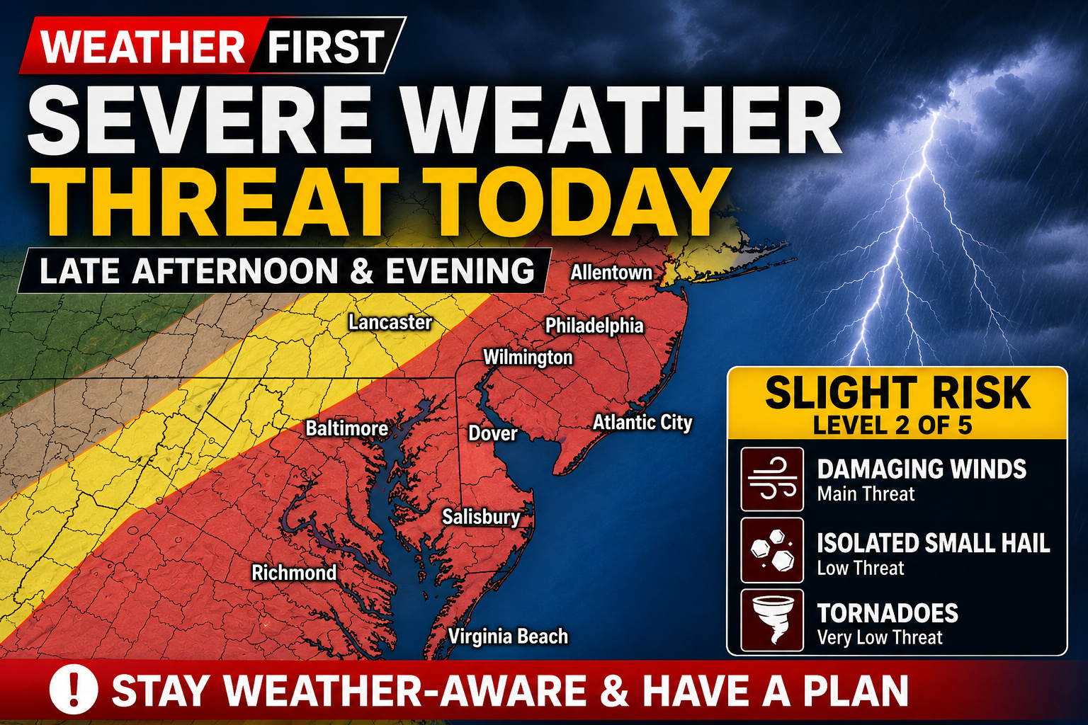
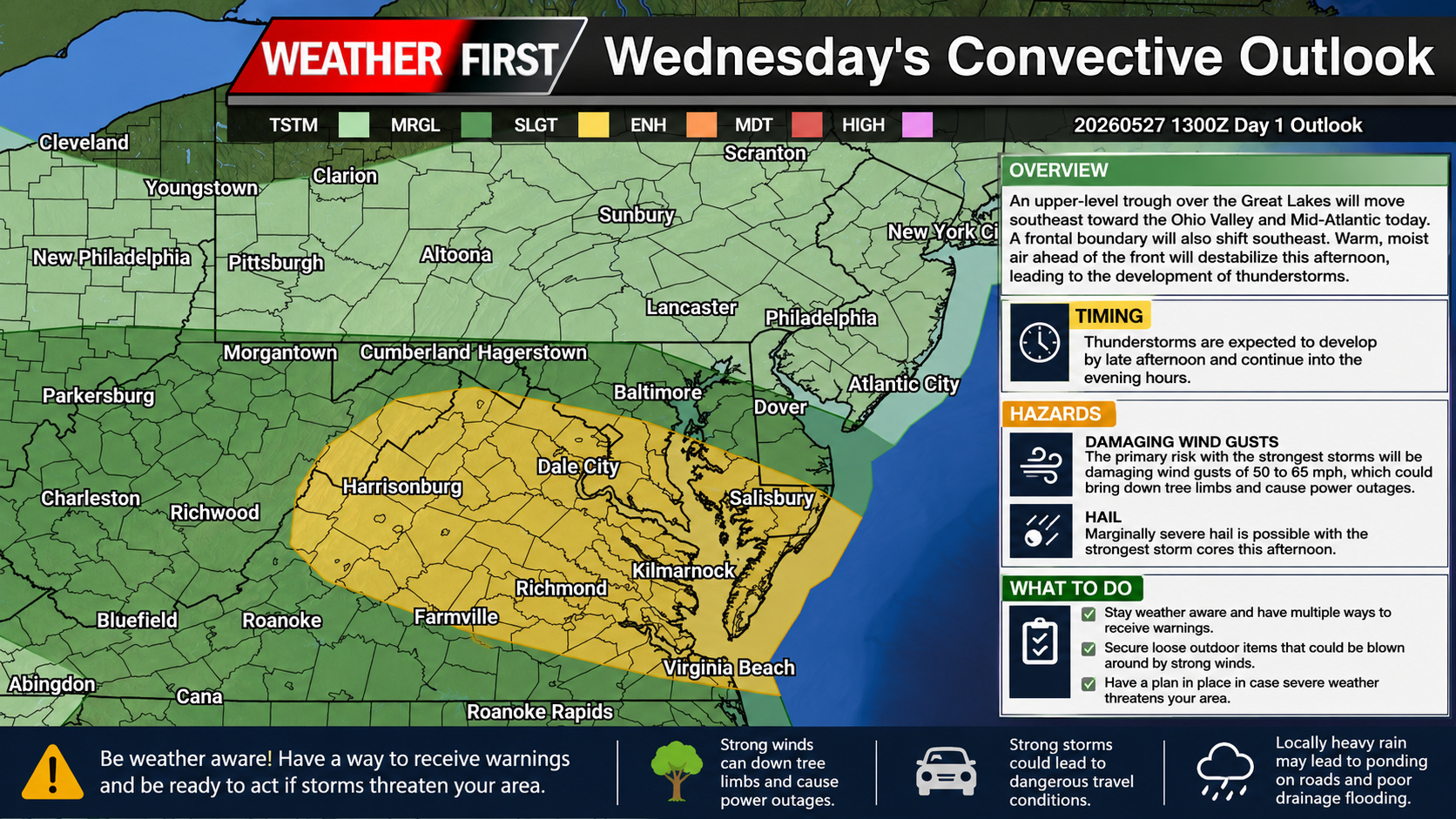
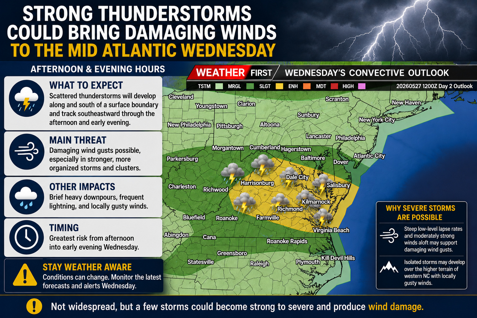
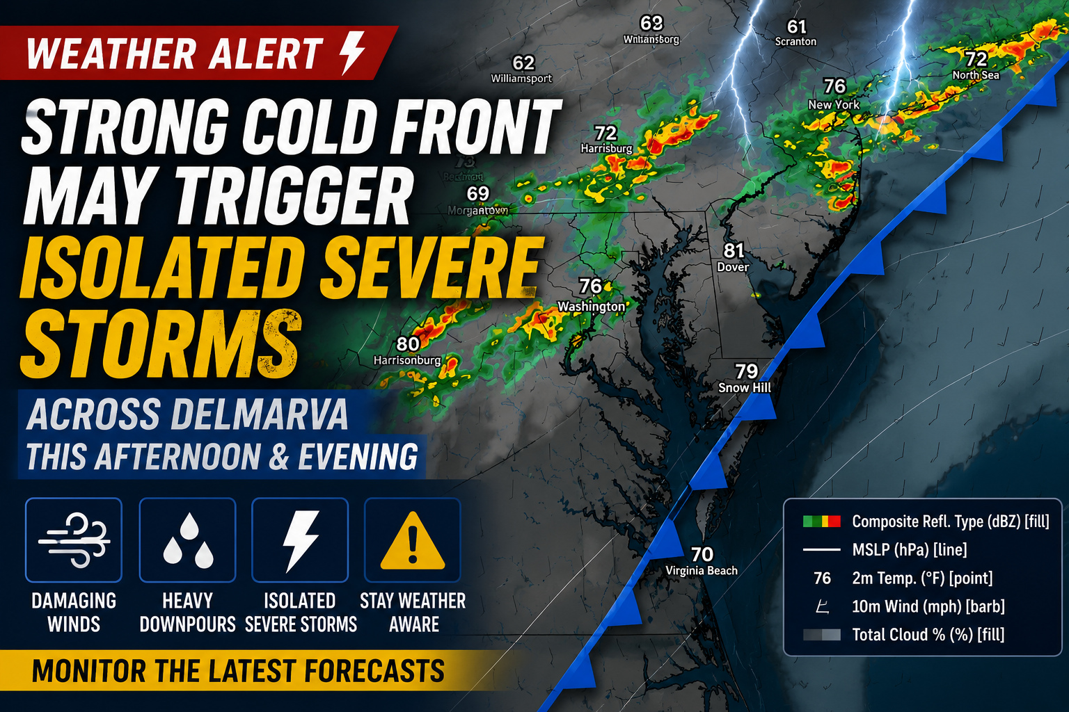
Residents across the Delmarva Peninsula should remain weather-aware today as another round of potentially severe thunderstorms is expected to develop late this afternoon and continue into the evening hours.
The Storm Prediction Center has placed the entire Delmarva region under a Slight Risk (Level 2 of 5) for severe thunderstorms, signaling the potential for scattered storms capable of producing damaging weather.
A cold front approaching from the west, combined with increasing influence from an upper-level disturbance, will provide the ingredients needed for thunderstorm development. While not everyone will see storms, those that do form could quickly become strong to severe.
Note that one of the biggest uncertainties today is storm coverage. A localized area of sinking air aloft may temporarily suppress thunderstorm development across portions of southeastern Pennsylvania, the Philadelphia metro area, and southern New Jersey. However, areas farther north and south of that corridor, including much of Delmarva, could see stronger storm development where instability is able to build.
The primary concern will once again be damaging straight-line winds, fueled by very hot temperatures, abundant low-level moisture, and an atmosphere favorable for powerful downbursts. Some wind gusts could exceed 60 mph, capable of bringing down trees, power lines, and causing localized damage.
An isolated instance of small hail cannot be ruled out, but the overall threat for large hail remains low. Likewise, atmospheric conditions are not particularly favorable for tornado development, making that risk minimal.
Temperatures climbing into the 90s will help fuel strong instability through the afternoon before thunderstorms begin to develop. Some storms may organize into clusters and race eastward across the peninsula through the early evening before gradually weakening after sunset.
Residents are encouraged to closely monitor the latest forecasts throughout the day and have multiple ways to receive weather warnings. If a Severe Thunderstorm Warning is issued for your location, move indoors immediately and stay away from windows until the storm passes.
Emergency personnel and community members conducted damage surveys Friday following a devastating line of severe weather that tore through areas south of Chicago, knocking out electricity for approximately 380,000 utility customers across Illinois and Indiana while causing significant disruptions to regional air travel.
Authorities reported no immediate fatalities or life-threatening injuries resulting from Thursday’s violent weather system.
Local authorities in Merrillville, Indiana, located roughly 33 miles southeast of Chicago, documented widespread destruction throughout their community. Residential structures and commercial buildings sustained severe damage, fallen trees and electrical lines created roadway blockages, and a portion of a local high school’s roofing system was completely destroyed.
Regional emergency response teams assisted local first responders in conducting search operations and evaluating affected neighborhoods, according to municipal officials posting updates on social media platforms. Work crews continued clearing debris from roadways throughout the overnight hours.
The National Weather Service confirmed that at least two additional tornadoes struck communities in the vicinity of Streator, Illinois, and Hebron, Indiana. Social media posts containing photographs and video footage revealed destruction patterns in these locations matching the devastation observed in Merrillville. Weather service meteorologists indicated they will conduct comprehensive damage surveys over the coming days to establish the total number of tornadoes that made ground contact across the affected region.
Emergency response teams in Streator, a manufacturing and agricultural community situated approximately 100 miles southwest of Chicago, also began damage assessment operations. City officials established a reunification facility for displaced community members at the municipal building while the Red Cross activated an emergency shelter.
Streator Mayor Tara Bedei confirmed no fatalities had been documented in her community. “We are incredibly grateful for the safety of our residents and the quick action of emergency personnel,” she said in a statement.
Emergency personnel in Hebron, positioned about 50 miles southeast of Chicago, also maintained operations throughout the night, according to official Facebook communications.
Jennifer Hall was inside her garage in Elkhart, Indiana, when the severe winds and precipitation intensified Thursday evening. Without warning, she reported hearing a tremendous impact and subsequently discovered that a large tree branch had penetrated her rental property’s roof. She deployed containers to collect rainwater entering through the opening.
“I’m just nervous because it’s just been one thing after another,” said Hall, explaining she just had surgery and her husband is out of town.
Electrical service remained disrupted for roughly 235,000 residences and commercial establishments throughout Illinois, including 144,000 customers in Cook County, which encompasses Chicago, based on poweroutage.us data. An additional 144,000 customers experienced power failures across Indiana.
The severe weather system caused flight delays and cancellations at multiple airports Thursday, including facilities in Chicago, Philadelphia and New York. Portions of the Northeast and mid-Atlantic regions also experienced challenging conditions due to elevated temperatures and humidity levels. Friday morning operations at Chicago’s O’Hare International and Midway International airports included 15 canceled flights and approximately 24 delayed departures, representing a small fraction of total scheduled service, according to FlightAware flight monitoring services.
These tornado events followed severe weather systems that moved through Midwest states Wednesday, causing power disruptions, structural damage and flight cancellations.
In Des Moines, Iowa, a 54-year-old man died at a homeless encampment in a park Wednesday after being hit by a tree that “broke apart and fell during strong storms,” police said in a statement. There were no immediate reports of other deaths or injuries from those storms.
Weather authorities have put a heat advisory into effect for the region, warning residents of dangerous temperature conditions expected throughout the day.
The advisory went into effect at 3:59 AM this morning and will remain active until 8:00 PM tonight, according to the National Weather Service Mount Holly office.
Officials are urging residents to take precautions during the hottest parts of the day and stay hydrated.
The National Weather Service office in Mount Holly, New Jersey has issued a heat advisory that went into effect Tuesday afternoon at 3:02 PM and will remain active until Wednesday evening at 8:00 PM.
Weather officials are urging residents to take necessary precautions during this period of elevated temperatures that could pose health risks to vulnerable populations.
The advisory serves as a warning for potentially dangerous heat conditions that require extra attention to staying cool and hydrated.
The threat for severe thunderstorms is expected to increase across the Mid-Atlantic on Friday as a cold front approaches from the west, bringing a more favorable environment for organized storm development.
After a more isolated storm threat on Thursday, Friday’s setup appears capable of producing more widespread thunderstorms during the afternoon and evening hours. A hot and humid air mass will remain firmly in place ahead of the advancing front, creating moderate to strong instability across the region. As daytime heating peaks, thunderstorms are expected to develop across portions of Pennsylvania and New York before expanding south and east into the Mid-Atlantic.
Forecast guidance suggests that storms may initially form as individual cells before merging into clusters or short line segments through the late afternoon and evening. As these storms organize, the primary hazard will become damaging straight-line winds, with some storms capable of producing localized wind damage and downed trees. An isolated instance of marginally severe hail cannot be ruled out with the strongest storms.
The Storm Prediction Center currently highlights the entire region in a Slight Risk (Level 2 of 5) for severe thunderstorms, reflecting the increasing confidence that at least scattered severe storms will develop. While the strongest upper-level winds are expected to remain west of the region, there should still be enough wind shear to support organized multicells and bowing segments capable of producing pockets of damaging winds.
Another factor that could enhance Friday’s severe weather potential is the possibility of a convectively induced disturbance moving into the region from the Great Lakes or Upper Ohio Valley. While the exact evolution remains uncertain, it could provide an additional source of lift and lead to greater storm coverage than currently anticipated.
For residents across Delmarva and the surrounding Mid-Atlantic, the greatest concern will be from late afternoon into the evening hours. While not everyone will experience severe weather, those that do could encounter damaging wind gusts, frequent lightning, torrential rainfall, and isolated hail.
Stay weather aware throughout Friday and have multiple ways to receive warnings, especially if you have outdoor plans. Forecast details will continue to be refined as newer data become available, but Friday currently appears to present the more significant severe weather threat compared to Thursday.
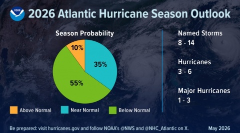
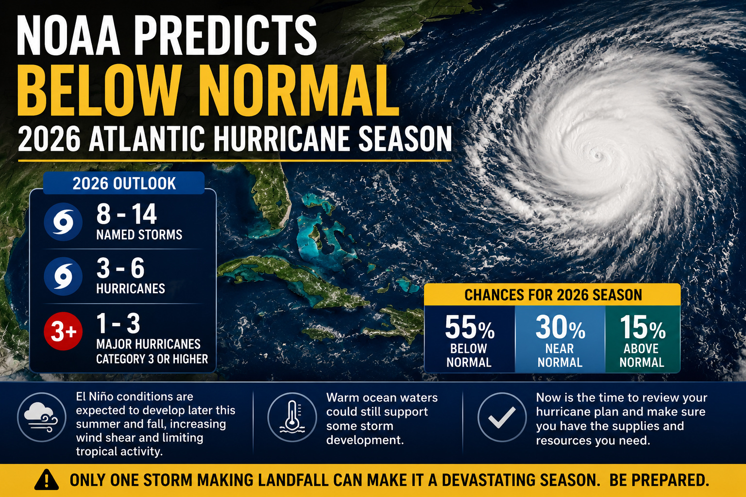
Federal weather officials confirmed Thursday that El Nino weather patterns have formed and are anticipated to grow stronger through the winter of 2026-27, according to the U.S. Climate Prediction Center.
The government weather agency noted that these El Nino conditions have emerged during the past month.
El Nino represents a natural climate event that happens when trade winds weaken, allowing warmer ocean temperatures to accumulate across the central and eastern equatorial Pacific. This weather pattern generally results in elevated global temperatures and shifts in weather systems, creating drought conditions in certain areas while producing excessive rainfall in others.
“El Nino is likely to have a negative impact on crop yields in Southeast Asia and India, where El Nino is typically associated with below-normal rainfall,” said Kyle Tapley, enterprise sales executive at Vaisala Xweather’s WeatherDesk.
India’s monsoon season provides approximately 70% of the nation’s annual precipitation and remains crucial for its farming industry, which represents roughly 18% of the country’s nearly $4 trillion economy. Reduced rainfall amounts could result in diminished harvests for crops including rice, cotton and soybeans, while also affecting winter crop production.
In Indonesia, rice producers are working to plant earlier than usual as they prepare for potential extended dry conditions this year. Malaysia’s economic minister has cautioned that El Nino may reduce crop production by 8% to 10% on average during this period.
“El Nino typically leads to a less-active U.S. hurricane season and we expect a below-normal Atlantic hurricane season this year. However, it is important to remember that a strong hurricane is still possible even in a less-active hurricane season,” Tapley said.
The current U.S. hurricane season started June 1 and continues until November 30.
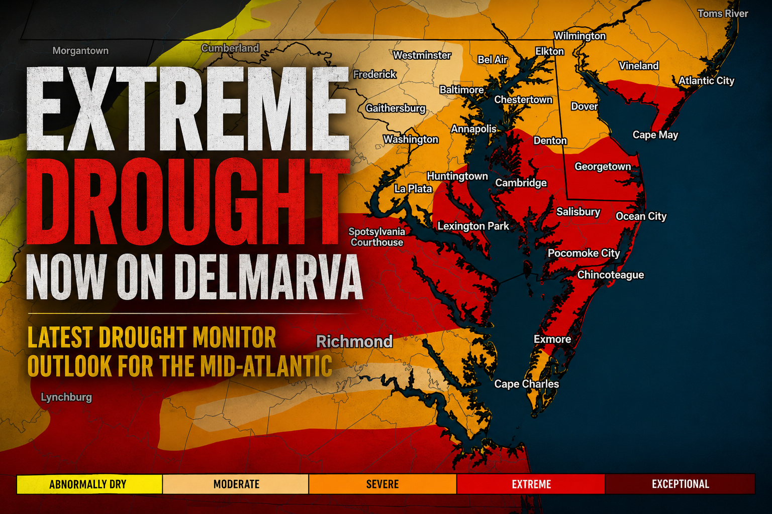
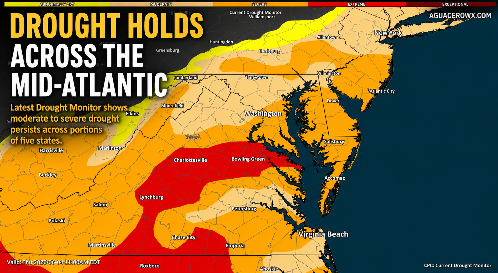
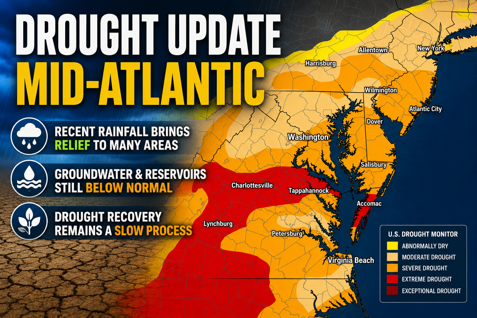
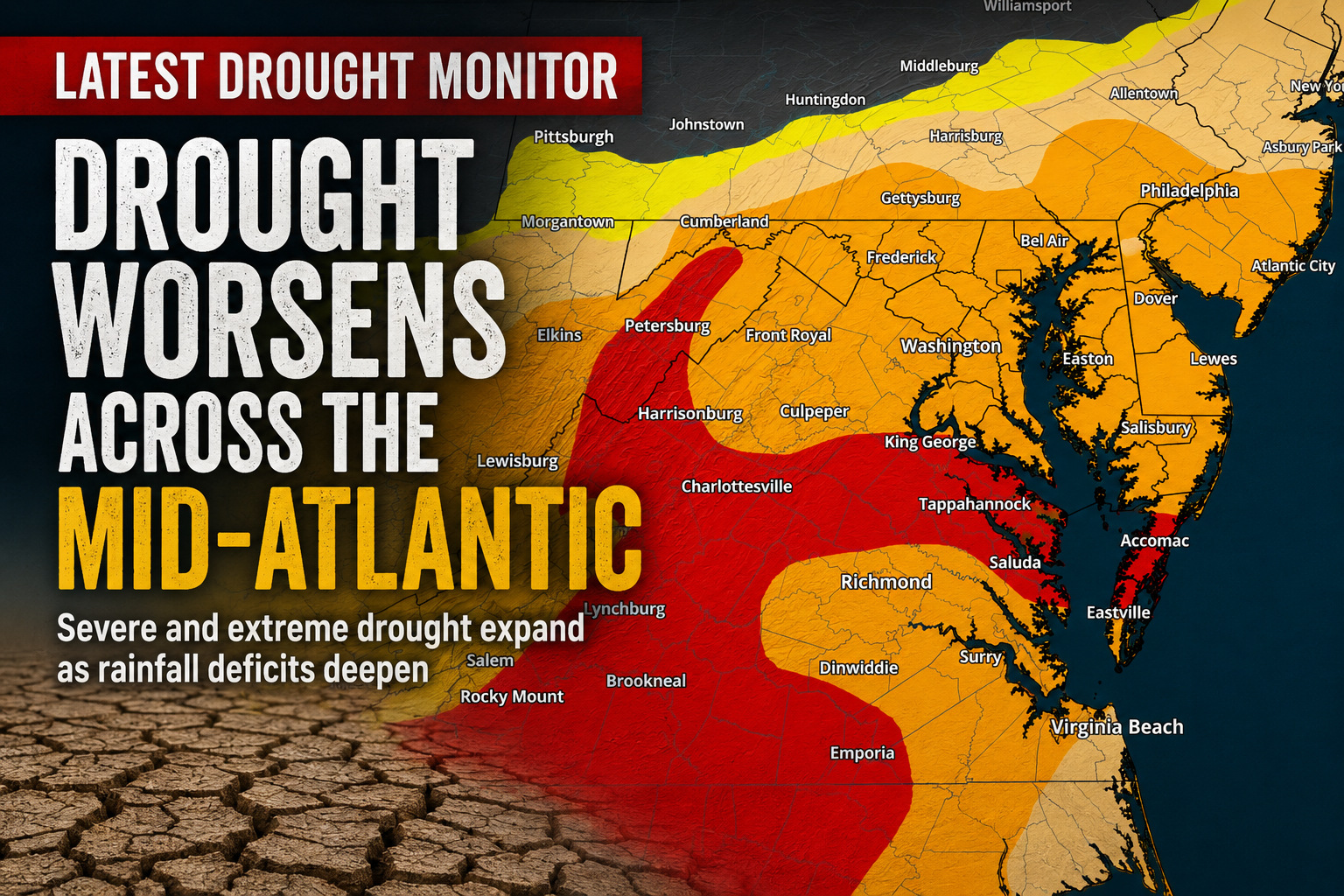
The latest U.S. Drought Monitor paints an increasingly concerning picture across the Mid-Atlantic, with portions of the Delmarva Peninsula now classified under Extreme Drought (D3) conditions as prolonged rainfall deficits continue to take a toll on the region.
The expansion of Extreme Drought marks another significant step in a worsening pattern that has developed over recent months. Much of the Mid-Atlantic continues to experience varying levels of drought intensity, with widespread Moderate to Severe Drought surrounding the hardest-hit areas and abnormally dry conditions extending well beyond them. The U.S. Drought Monitor is updated every Thursday using a combination of precipitation data, soil moisture observations, streamflow measurements, groundwater information, and reports from local experts. Recent updates show the continued deterioration of conditions across parts of Delmarva and the surrounding region.
For residents across Delaware and Maryland’s Eastern Shore, the impacts are becoming increasingly visible. Dry soils, stressed vegetation, declining streamflows, and growing concerns for agriculture are all consequences of the prolonged lack of meaningful rainfall. The ongoing dryness also raises the risk of brush and woodland fires, especially during periods of low humidity and gusty winds.
Water managers and agricultural interests will be closely monitoring conditions through the summer, particularly if the region experiences additional stretches of hot weather with limited precipitation. While scattered thunderstorms can provide localized relief, they often fail to deliver the widespread soaking rainfall needed to significantly improve long-term drought conditions.
The drought also comes after an exceptionally dry spring across parts of the Mid-Atlantic. Climate data indicate that Delaware experienced one of its driest meteorological springs on record, helping to intensify moisture deficits that have persisted into early summer.
Looking ahead, meaningful and widespread rainfall will be needed over an extended period to reverse the growing deficits. Until then, residents should remain mindful of local burn restrictions, practice water conservation when possible, and stay informed as drought conditions continue to evolve across the region.
Federal weather officials confirmed today that El Niño has officially developed in the tropical Pacific Ocean, with forecasters issuing an El Niño Advisory as the climate phenomenon is anticipated to grow stronger through the fall season.
The National Weather Service announced that El Niño, which represents the warm phase of the El Niño Southern Oscillation climate pattern, is projected to reach moderate or strong intensity this autumn. Weather experts predict a 63% probability that sea surface temperatures will rise more than 2.0°C above normal in the Pacific monitoring zone. Should temperatures cross this threshold, NOAA would classify the event as a “very strong” El Niño.
El Niño occurs when equatorial Pacific Ocean temperatures climb 0.5°C above typical levels for multiple consecutive months. Weather scientists also track atmospheric conditions over this Pacific region, monitoring for changes in the Walker Circulation – a large-scale east-to-west airflow pattern created by temperature and pressure variations between the warm western Pacific and cooler eastern waters. El Niño is declared when this circulation pattern weakens and warmer waters move eastward toward South America.
The climate pattern typically reaches peak strength during winter months, with its most significant global effects occurring during northern hemisphere winter seasons. During typical El Niño winters, the jet stream over the northern Pacific tends to move southward, directing storm systems across the southern portion of the United States. This southward shift also creates drier conditions over the Northern Rockies and Ohio and Tennessee river valleys. Temperature-wise, El Niño frequently produces warmer than normal winter conditions across northern U.S. regions.
“Every El Niño is not the same; each one is unique with its own imprint on our weather,” stated Ken Graham, director of NOAA’s National Weather Service. “Advanced monitoring and an improved understanding of El Niño patterns allow the NWS to better predict and better prepare the public and our core partners for what is to come.”
Common El Niño impacts include stronger upper-level winds that typically reduce storm and hurricane formation in the Atlantic Basin, while weaker winds encourage tropical development in the eastern and central Pacific regions. The phenomenon also brings stormier conditions to the Southern U.S., increasing chances for both rain and snow during El Niño winters.
High tide flooding risks may increase in parts of the United States, particularly along the West Coast. The climate pattern also affects marine life migration patterns, with warm water species moving northward while cold water species relocate farther north or into deeper waters. These behavioral shifts impact fish growth, survival, and reproduction rates. Previous El Niño episodes have also contributed to increased harmful algal bloom formation along the U.S. West Coast.
In February, NOAA officially began using the Relative Oceanic Niño Index for monitoring sea surface temperatures and predicting El Niño and La Niña events. Unlike the traditional Oceanic Niño Index, which uses a fixed 30-year temperature baseline, the new index updates monthly, providing more reliable identification of climate events.
NOAA’s climate monitoring team has tracked both the traditional and new indices since 2021. After observing several years of climate phases and corresponding atmospheric responses, scientists determined that the new index better correlates with expected Walker Circulation changes, offering more valuable information to weather experts, emergency managers, and the public.
Severe thunderstorms ripped across the Midwest on Wednesday, leaving hundreds of thousands in the dark and creating travel chaos at Chicago’s major airports with over 1,000 flight disruptions.
Weather officials issued tornado warnings throughout Illinois, Kansas, northern Missouri and southern Iowa on Wednesday, with severe thunderstorm watches covering portions of the Great Lakes region.
The storm system reached the Chicago metropolitan area Wednesday afternoon, toppling trees and causing structural damage to buildings throughout the region.
Both Chicago O’Hare International Airport and Chicago Midway International Airport issued temporary flight holds Wednesday evening as thunderstorms moved through the area. John F. Kennedy International Airport in New York implemented similar ground stops due to severe weather conditions.
Flight tracking service FlightAware reported that by Wednesday night, more than 1,000 departing and arriving Chicago flights had been either delayed or cancelled.
Powerful winds tore portions of roofing from an apartment complex in the Chicago region, displacing residents, NBC 5 Chicago reported. Additional damage included collapsed barns in Wisconsin, destroyed structures in rural northern Missouri, and numerous fallen trees and power lines throughout the Midwest, as documented in online photos and videos.
Illinois experienced the most significant power disruptions with over 264,000 customers losing electricity, primarily concentrated in Cook County, while Michigan saw nearly 140,000 outages, according to poweroutage.com. Additional blackouts affected Kansas, Wisconsin, Iowa, Indiana and Ohio.
Commonwealth Edison Company, the electric utility serving northern Illinois, reported that the storms had brought down electrical poles and transmission lines.
“We know this is challenging and will restore service as safely and quickly as conditions allow,” the company said in a post on X.
NOAA has officially ushered in a new chapter in space weather forecasting with the start of operational service for its SOLAR-1 observatory, a next-generation mission designed to provide earlier and more accurate warnings of potentially disruptive solar storms. The milestone represents a significant advancement in the nation’s ability to monitor activity on the Sun and protect critical infrastructure both on Earth and in space.
Formerly known as Space Weather Follow On-Lagrange 1 (SWFO-L1), the spacecraft was renamed SOLAR-1 after reaching its permanent position near the Sun-Earth L1 Lagrange point, roughly one million miles from Earth. From this unique vantage point, the observatory continuously monitors the solar wind and tracks coronal mass ejections (CMEs) before they arrive at our planet.
The mission’s primary goal is to improve NOAA’s ability to issue timely space weather watches, warnings, and forecasts. Powerful solar storms can interfere with satellite operations, GPS navigation, radio communications, aviation, electric power grids, and even astronaut safety during missions beyond Earth’s protective atmosphere. Earlier detection means operators have more time to prepare and reduce potential impacts.
SOLAR-1 carries a suite of advanced instruments, including a compact coronagraph that images the Sun’s outer atmosphere and sensors that continuously measure the solar wind flowing toward Earth. The real-time data are transmitted directly to NOAA’s Space Weather Prediction Center, where they are incorporated into operational forecasts used by governments, utilities, airlines, emergency managers, satellite operators, and researchers around the world.
For skywatchers, improved space weather forecasting could also mean better predictions of auroral activity. During periods of heightened solar activity, strong geomagnetic storms can push the Northern Lights much farther south than usual, occasionally making them visible across portions of the Mid-Atlantic and Delmarva under favorable conditions. More accurate monitoring from SOLAR-1 should help forecasters better pinpoint the timing and intensity of these events.
As Solar Cycle 25 continues to produce frequent flares and coronal mass ejections, NOAA’s newest observatory is expected to play a critical role in safeguarding modern technology while advancing our understanding of the dynamic relationship between the Sun and Earth. With continuous observations from one of the most strategically important locations in space, SOLAR-1 marks a major leap forward in operational space weather monitoring.
The National Weather Service office in Mount Holly, New Jersey has issued a heat advisory that went into effect Monday at 2:36 PM EDT and will remain in place until Wednesday at 8:00 PM EDT.
The weather service issued the advisory on June 10th, warning of dangerous heat conditions that will persist through the middle of the week.
Residents are advised to take appropriate precautions during this period of elevated temperatures and heat-related risks.
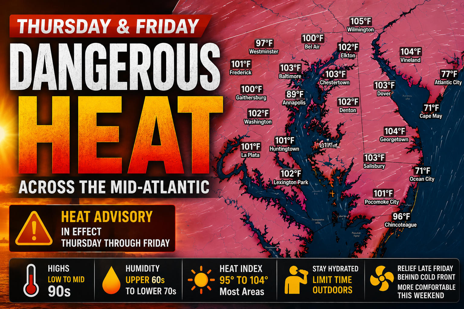
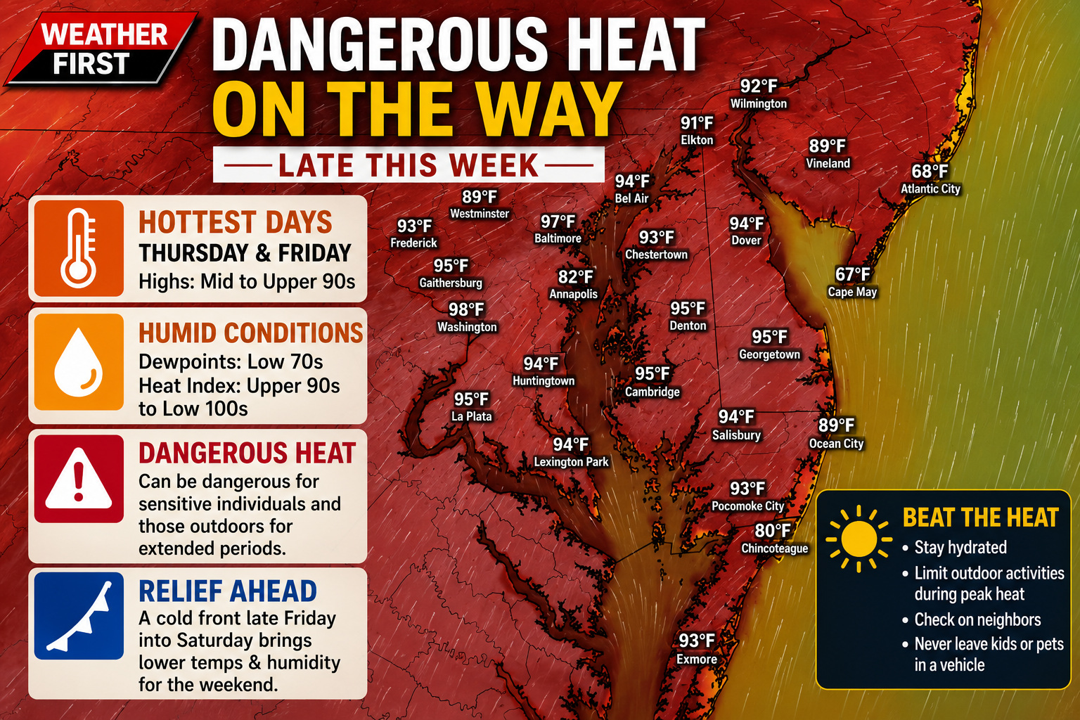
The Mid-Atlantic is set for another round of dangerous summer heat as temperatures surge into the 90s on both Thursday and Friday, with heat index values climbing above 100 degrees in many communities. The combination of hot temperatures and high humidity has prompted Heat Advisories across much of the region, including portions of Delmarva.
A strengthening area of high pressure centered over the Southeast will continue to pump warm, humid air into the region through the end of the workweek. While an upper-level disturbance over Canada may slightly limit just how hot temperatures become, it will do little to reduce the risk of dangerous heat.
High temperatures on Thursday are expected to reach the low to mid 90s across much of the Mid-Atlantic, with many locations climbing even higher on Friday. When combined with dew points in the upper 60s to lower 70s, it will feel more like 95 to 104 degrees during the hottest part of the afternoon.
The highest heat index values are expected across southeastern Pennsylvania, central and southern New Jersey, and much of Delmarva, where prolonged outdoor exposure could quickly lead to heat-related illnesses.
Residents are encouraged to stay hydrated, limit strenuous outdoor activities during the afternoon hours, wear lightweight clothing, and check on vulnerable family members and neighbors. Never leave children or pets unattended in vehicles, where temperatures can become life-threatening in just minutes.
The heat won’t be the only concern. Scattered thunderstorms are expected to develop Thursday and Friday afternoon, with some storms capable of becoming severe and producing damaging winds. While these storms may offer temporary relief from the heat, they could also create hazardous conditions across the region.
Relief is expected to arrive behind a cold front late Friday. While temperatures will remain warm through the weekend with highs generally in the upper 80s to lower 90s, humidity levels are forecast to drop noticeably, making conditions significantly more comfortable and reducing the threat for additional heat advisories.
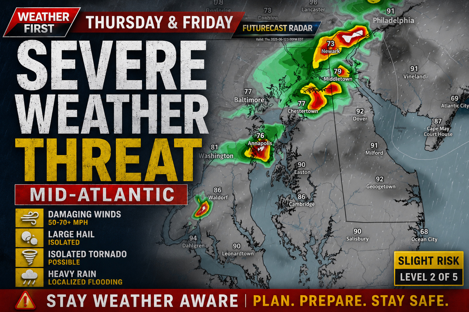
After a stretch of dangerous heat and humidity, attention is now turning to an increasing threat for severe thunderstorms across the Mid-Atlantic on both Thursday and Friday. We are monitoring multiple disturbances that could trigger strong to severe storms capable of producing damaging winds, large hail, and even an isolated tornado.
The overall weather pattern will remain favorable for thunderstorm development through the end of the workweek as hot, moisture-rich air remains firmly in place across the region. With temperatures climbing into the upper 80s and 90s and dewpoints well into the 60s and lower 70s, the atmosphere will become increasingly unstable each afternoon.
Thursday: Damaging Winds the Primary Concern
Thursday’s storms are expected to be driven largely by daytime heating, but an approaching disturbance moving out of the Midwest should provide enough additional lift to enhance thunderstorm development during the afternoon and evening hours.
The Storm Prediction Center has placed the entire Mid-Atlantic in a Slight Risk (Level 2 of 5) for severe weather. While wind shear is expected to remain relatively modest, the combination of hot temperatures and abundant moisture should create an environment favorable for strong thunderstorms.
The primary hazard will be damaging straight-line winds, although some storms could also produce large hail and a brief tornado if they become more organized.
Friday: Cold Front May Bring a More Widespread Severe Threat
The severe weather threat continues into Friday as an upper-level trough and an approaching cold front move closer to the region. These larger-scale weather features are expected to provide stronger forcing for thunderstorm development compared to Thursday.
Another Slight Risk has been issued across the region, with scattered to numerous thunderstorms expected to develop during the afternoon and evening hours.
As storms organize into clusters or bowing segments, the potential exists for a more concentrated area of damaging wind gusts pushing eastward toward the Mid-Atlantic coastline. Some storms may also produce marginally severe hail, while isolated rotating storms cannot be completely ruled out.
Main Hazards
Damaging wind gusts of 50 to 70+ mph
Large hail
Frequent cloud-to-ground lightning
Torrential rainfall and localized flooding
An isolated brief tornado cannot be ruled out
Stay Weather Aware
While there is still uncertainty regarding the exact timing and placement of the strongest storms on both days, confidence is increasing that at least scattered severe thunderstorms will develop somewhere across the Mid-Atlantic Thursday and Friday.
Residents across Delmarva and the surrounding region should keep a close eye on the latest forecasts and be prepared to receive watches and warnings, especially during the afternoon and evening hours when storm intensity is expected to peak.
The good news is that once the cold front moves through, the weekend forecast has trended drier with a gradual decrease in humidity and a return to more comfortable conditions.
Residents across Delmarva should prepare for the hottest weather of the year so far as a stretch of dangerous heat and humidity is expected to develop during the latter half of the week.
We are closely monitoring a strengthening ridge of high pressure that will build across the Mid-Atlantic beginning Wednesday and continuing into Friday. While recent forecast guidance suggests the ridge may not be quite as strong as earlier projections due to an upper-level disturbance tracking across Canada, temperatures are still expected to soar well above normal levels.
The combination of intense sunshine, warm air aloft, and moisture streaming northward from the Southeast will push afternoon temperatures into the low to mid-90s across much of Delmarva on Thursday and Friday. When combined with dew points in the lower 70s, it will feel significantly hotter.
Heat index values, which measure how hot it feels when humidity is factored in, are forecast to climb into the upper 90s and could exceed 100 degrees in some locations. The highest heat indices are expected across inland sections of Delaware, Maryland’s Eastern Shore, and portions of southern New Jersey.
While temperatures in the 90s are not uncommon during summer, the added humidity can place significant stress on the human body, especially for those working outdoors, participating in strenuous activities, or lacking access to air conditioning. Young children, older adults, and individuals with chronic health conditions are particularly vulnerable to heat-related illnesses.
Forecasts indicate that Heat Advisories may eventually be issued as confidence continues to increase in the magnitude of the heat. Residents are encouraged to stay hydrated, limit outdoor activities during the hottest part of the day, and check on neighbors who may be vulnerable to the extreme conditions.
The heat wave is not expected to last indefinitely. A cold front is forecast to approach and move through the region late Friday into Saturday. This front should bring a modest drop in temperatures and humidity levels for the weekend. While conditions will remain seasonably warm, the oppressive heat and tropical humidity currently expected late this week should ease heading into early next week.
Until then, Delmarva residents should prepare for several days of dangerous summer heat and take appropriate precautions to stay safe.
Powerful winds and dangerous seas hammered Wellington, New Zealand on Tuesday, shutting down air and water transportation while officials ordered hundreds of people living near the southern coastline to leave their homes.
Strong gusts at Wellington’s airport temporarily flipped a small aircraft onto its wing and wheel after the plane had completed its landing, according to an airport spokesperson who provided details via email.
“Nobody was injured and it was quickly righted,” the spokesperson stated.
The New Zealand Herald reported that passengers had already gotten off the aircraft when the wind caused it to tip over.
Wellington’s airport saw approximately eight flight cancellations. Air New Zealand notified travelers that predicted strong winds might affect departures from Wellington and provided alternative booking arrangements, according to Radio New Zealand’s coverage.
Officials declared an emergency situation for certain areas of Wellington after meteorologists issued warnings about waves reaching heights of 9 metres (29.5 ft) along the southern shoreline.
“We are now entering the forecast period for most significant swell impacts. If you are in the evacuation zone and have not left your property, please shelter in place,” Wellington City Council announced through a Facebook message.
Passenger boat operations connecting New Zealand’s North and South Islands were suspended Tuesday.
Weather officials predicted waves would increase quickly during Tuesday morning and early afternoon hours along eastern coastlines of both major islands and at the Chatham Islands.
Jonathan Delich, an Island Bay resident who runs Cook Strait Fishing Charters, informed the New Zealand Herald that he had canceled all Tuesday and Wednesday bookings.
“We wouldn’t take you fishing even if you wanted to … no one in their right mind would go out on the water today,” Delich commented.
MIAMI (AP) — Weather officials announced Monday that Tropical Storm Cristina has developed in Pacific waters near Nicaragua.
According to the National Hurricane Center in Miami, the storm is packing maximum sustained winds of 45 mph (75 kph). The system’s center was positioned 100 miles (160 kilometers) west-southwest of Managua, Nicaragua, and approximately 170 miles (275 kilometers) southeast of San Salvador, El Salvador.
Weather officials have issued a tropical storm warning spanning from Puerto Sandino to the Guatemala/El Salvador border.
The storm system is expected to produce rainfall amounts between 4 and 8 inches across coastal areas of Nicaragua, Honduras, El Salvador and Guatemala through Thursday, with some locations potentially receiving up to 12 inches (30 centimeters) of precipitation.
This marks the second tropical storm currently active in the Eastern Pacific Ocean. Tropical Storm Boris was also churning off Mexico’s coast Monday and was projected to reach landfall there on Tuesday.
A significant surge of summer heat is expected to develop across the Delmarva Peninsula during the second half of the week, with forecasters increasingly concerned about potentially dangerous heat and humidity levels by Thursday and Friday.
After a relatively warm start to the week, a warm front is forecast to move north through the region on Wednesday. This will open the door for a much hotter and more humid air mass to overspread the Mid-Atlantic, setting the stage for the hottest weather of the season so far.
Current forecast guidance indicates Thursday will likely be the peak of the heat wave. Strong southerly winds behind the warm front will transport very warm air into the region, allowing temperatures to climb well into the 90s across much of Delmarva. When combined with increasing humidity, heat index values could reach or exceed 100 degrees during the afternoon hours.
While there remains some uncertainty regarding Friday’s temperatures, confidence is high that the region will remain uncomfortably hot. Some forecast models suggest an upper-level ridge could strengthen over the East Coast, resulting in temperatures even warmer than Thursday. Other solutions indicate a weak disturbance could bring additional clouds and slightly lower temperatures. Regardless of the exact scenario, widespread highs in the 90s are expected.
The humidity will play a major role in determining the overall impacts of this heat event. Persistent southerly flow will continue to transport moisture northward from the Gulf and Atlantic, keeping dew points elevated. This combination of heat and humidity will increase the risk of heat-related illnesses, especially for those spending extended periods outdoors.
Residents are encouraged to stay hydrated, limit strenuous outdoor activities during the hottest part of the day, and check on vulnerable individuals, including the elderly, young children, and pets.
Relief from the heat appears possible over the upcoming weekend as a pair of cold fronts approach the region. The timing of these fronts remains uncertain, but they should eventually bring cooler temperatures and a reduction in the threat for extreme heat.
For now, Delmarva residents should prepare for several days of summer-like conditions, with Thursday currently appearing to be the most dangerous day of the upcoming heat wave.
Weather officials have issued a severe thunderstorm watch for the region, alerting residents to potentially dangerous weather conditions developing this evening.
The National Weather Service office in Mount Holly, New Jersey, activated the watch at 7:44 PM on June 6th, with the alert remaining in effect until 10:00 PM the same day.
A severe thunderstorm watch indicates that atmospheric conditions are favorable for the development of severe weather, including the possibility of damaging winds, large hail, and heavy rainfall.
Residents are advised to stay informed about changing weather conditions and be prepared to take shelter if warnings are upgraded or severe weather develops in their area.
Weather officials issued an alert for dangerous thunderstorm conditions Thursday evening, warning residents to take precautions during the storm system.
The National Weather Service office in Mount Holly, New Jersey, released the severe thunderstorm warning at 6:55 PM EDT on June 6th. The warning remained in effect until 7:15 PM EDT the same day.
The brief but intense weather alert covered a 20-minute window when conditions were expected to be most severe for the affected area.
Weather officials have put a severe thunderstorm watch into effect for this evening, running from 6:15 PM through 10:00 PM tonight.
The National Weather Service office in Mount Holly, New Jersey issued the weather alert earlier this evening as conditions favor the development of dangerous storms across the area.
Residents should monitor weather conditions closely and be prepared to take shelter if severe weather develops in their vicinity during the watch period.
Weather officials issued a severe thunderstorm warning on Thursday evening, alerting residents to potentially dangerous conditions.
The National Weather Service office in Mount Holly, New Jersey, issued the warning on June 6th at 6:17 PM EDT. The alert remained in effect until 7:15 PM EDT the same day.
The warning was part of the weather service’s ongoing monitoring of severe weather conditions in the region.
Weather officials have issued a severe thunderstorm watch that remains in effect until 10:00 PM this evening.
The National Weather Service office in Mount Holly, New Jersey issued the watch at 4:45 PM today, alerting residents to monitor conditions and prepare for potentially severe weather.
The watch indicates that atmospheric conditions are favorable for the development of severe thunderstorms in the area during the specified time period.
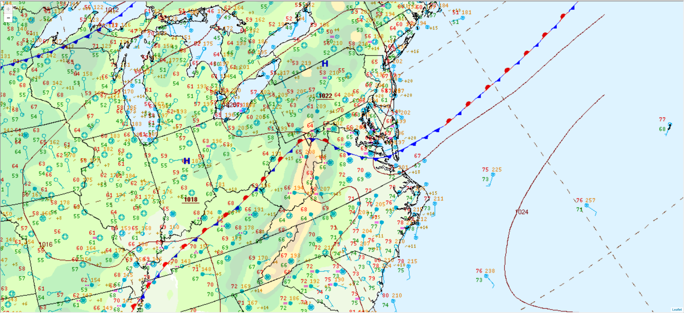
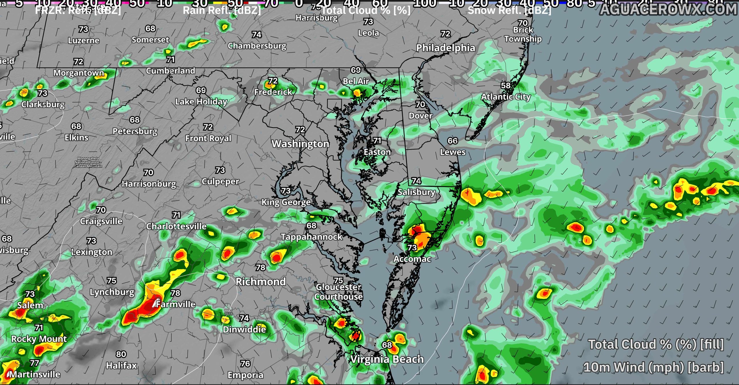
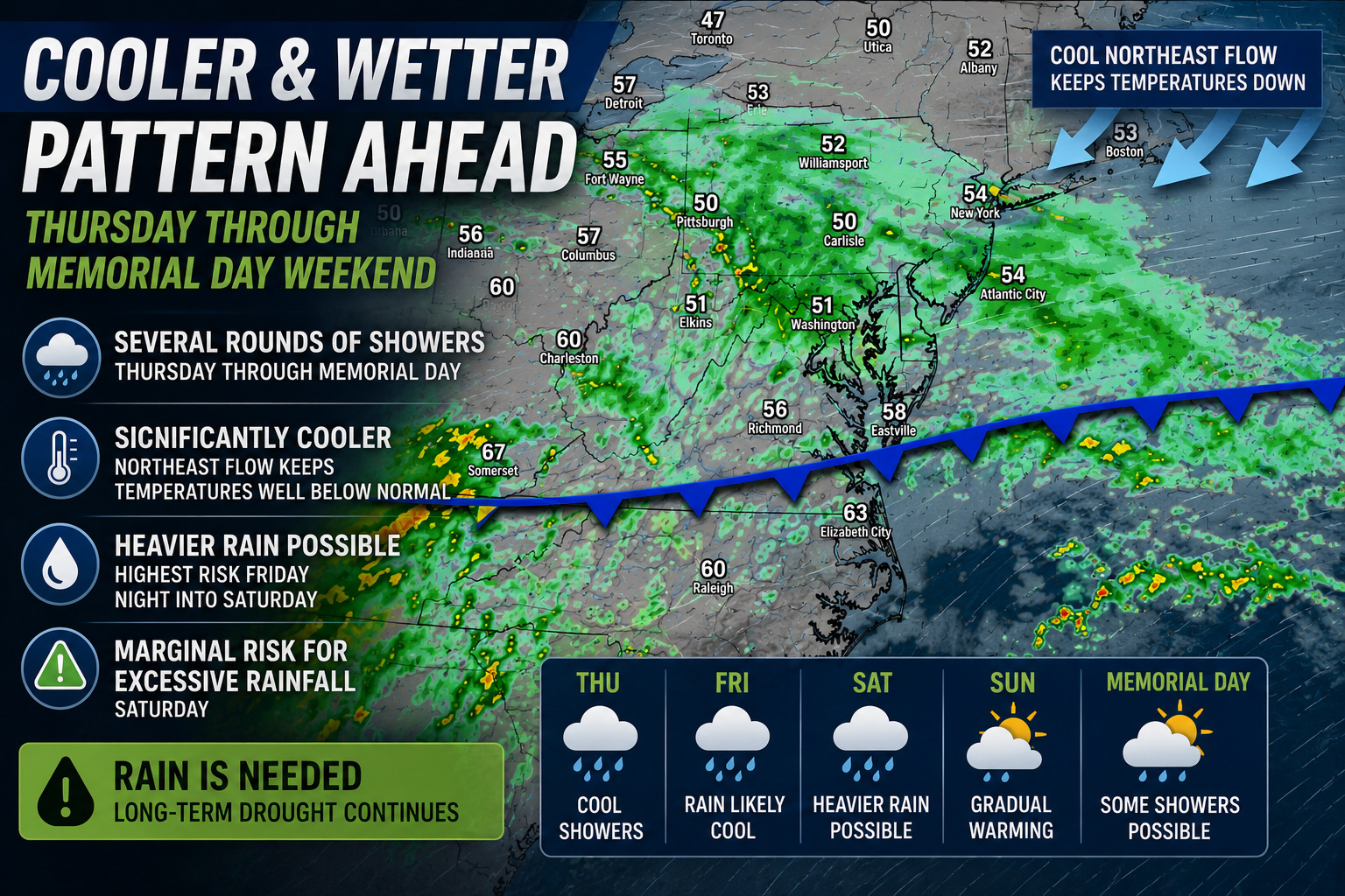
A stretch of summer-like weather across the Delmarva Peninsula will come to an end this weekend as a cold front sweeps through the region Saturday night, bringing the potential for scattered showers and thunderstorms, including a few strong storms.
Saturday is expected to remain largely dry with warm temperatures and increasing humidity. However, attention turns to the west Saturday evening as thunderstorms develop ahead of an approaching cold front. Those storms are expected to move eastward into portions of the Mid-Atlantic during the overnight hours.
The latest outlook from the National Weather Service’s Storm Prediction Center places areas north and west of the Interstate 95 corridor under a Marginal Risk for severe weather, with a Slight Risk extending into portions of northern New Jersey and the southern Poconos. While the greatest severe threat is expected to remain northwest of Delmarva, a few stronger storms could survive long enough to reach parts of eastern Pennsylvania, New Jersey, and northern sections of the region.
Damaging wind gusts and hail are the primary threats with any stronger thunderstorms. The overnight timing is expected to limit the overall severe weather risk as storms will likely weaken after sunset and continue to diminish as they move eastward.
Rainfall amounts also appear somewhat disappointing for a region desperately in need of moisture. Forecast rainfall totals generally range from one-tenth to one-quarter inch north and west of I-95, with locally higher amounts possible under heavier thunderstorms. Some communities may receive little or no rainfall at all.
The lack of widespread rainfall continues to be a concern as portions of Delaware, Maryland, New Jersey, and Pennsylvania remain under drought watches or drought warnings. Unfortunately, this frontal passage may represent the only meaningful opportunity for measurable precipitation over the next week.
Any lingering showers along the Delaware and New Jersey beaches Sunday morning should gradually move offshore as a secondary cold front pushes through the region. Drier and less humid conditions are expected to return later Sunday, providing a pleasant finish to the weekend.
Residents are encouraged to monitor forecasts through Saturday, especially if they have outdoor plans during the evening and overnight hours. While widespread severe weather is not expected across Delmarva, a few thunderstorms could still produce gusty winds, brief heavy rain, and frequent lightning.
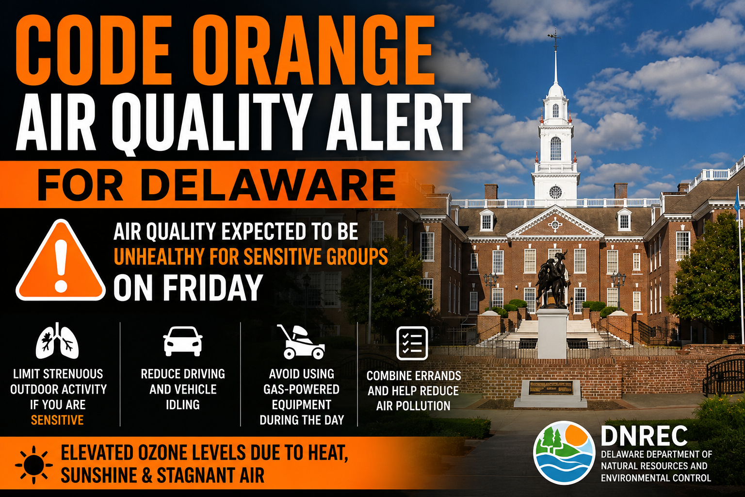
Delaware residents are being urged to take precautions Friday as the Delaware Department of Natural Resources and Environmental Control (DNREC) has issued a Code Orange Air Quality Action Day for the entire state due to elevated ozone levels. The alert means air quality is expected to reach levels considered “Unhealthy for Sensitive Groups”, including children, older adults, and individuals with asthma, lung disease, or other respiratory conditions.
According to DNREC forecasters, a combination of weather conditions is expected to promote ozone formation across the First State. A morning temperature inversion will trap pollutants near the ground, while mostly sunny skies and afternoon temperatures climbing into the lower 90s will help increase ozone production. Light west-southwest winds will also allow pollutants to accumulate and drift into Delaware from neighboring states. As a result, ozone levels are forecast to reach an Air Quality Index (AQI) value of 101, placing Delaware in the Code Orange category.
Ground-level ozone forms when emissions from vehicles, power plants, and industrial sources react with sunlight and heat. Unlike the protective ozone layer high in the atmosphere, ground-level ozone can irritate the lungs, trigger asthma attacks, reduce lung function, and make it more difficult to breathe, especially during periods of prolonged outdoor activity.
DNREC recommends that sensitive groups limit strenuous outdoor activities during the afternoon and early evening hours when ozone concentrations are typically highest. Residents can also help reduce air pollution by limiting daytime driving, avoiding prolonged vehicle idling, postponing the use of gasoline-powered lawn equipment until evening, and combining errands into a single trip.
The air quality outlook is expected to improve somewhat this weekend. While warm temperatures and sunshine will continue to support ozone production on Saturday, increasing winds should help disperse pollutants. By Sunday, a weak cold front is expected to bring northwesterly winds that will gradually usher cleaner air into the region.
For the latest air quality forecasts and real-time conditions, residents can visit DNREC’s Air Quality Forecast page or monitor conditions through the EPA’s AirNow website.
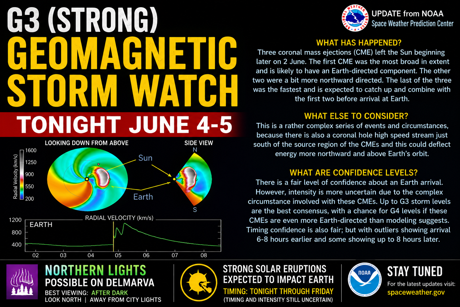
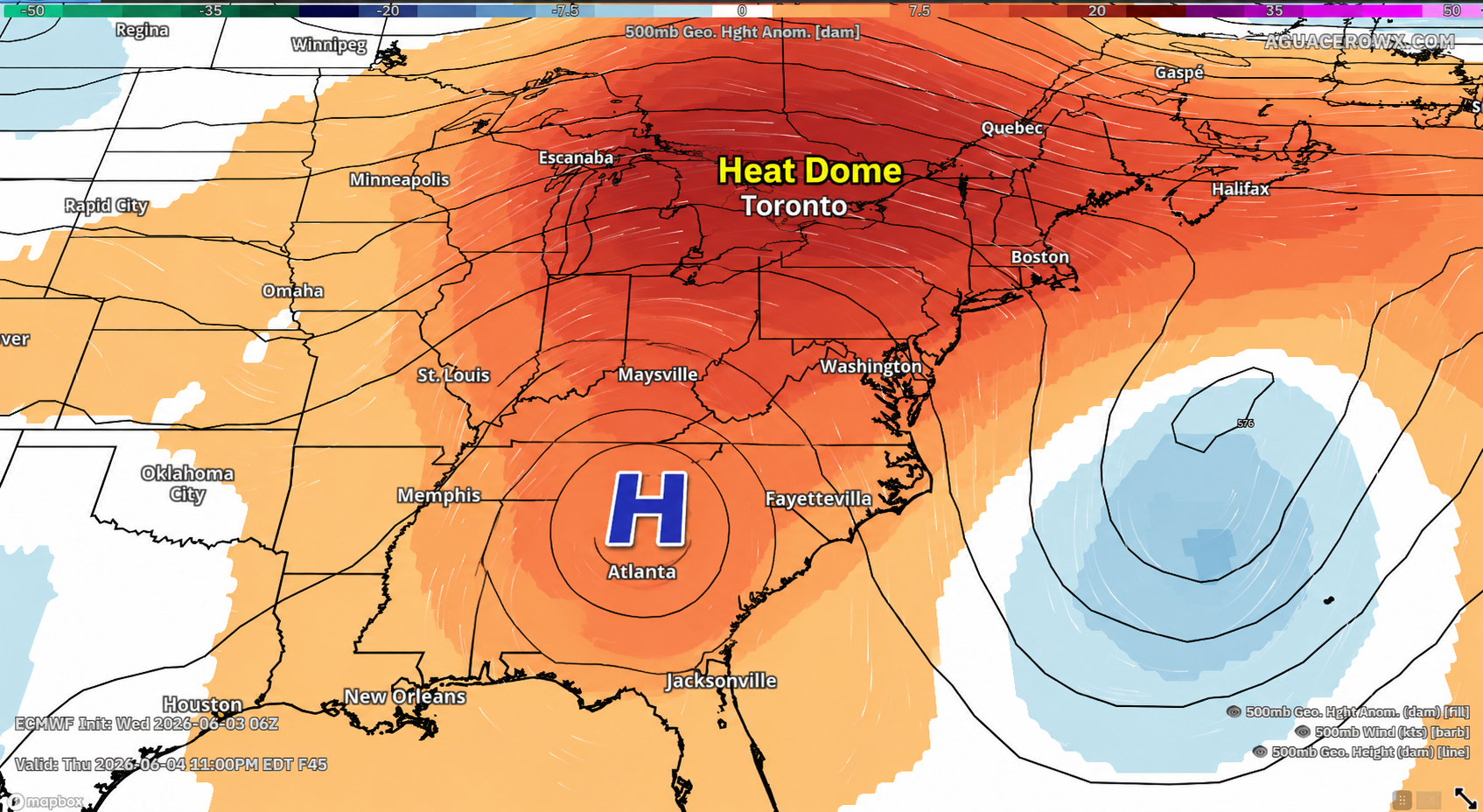
The National Oceanic and Atmospheric Administration’s Space Weather Prediction Center (SWPC) has issued a G3 (Strong) Geomagnetic Storm Watch for June 4-5 as multiple coronal mass ejections (CMEs) from the Sun are expected to impact Earth’s magnetic field. The event follows three significant solar eruptions that occurred on June 2 and June 3, including an X-class solar flare and two strong M-class flares.
According to NOAA, the three CMEs are expected to combine as they travel through space before reaching Earth. Forecasters have a fairly high level of confidence that the storm will arrive, though the exact intensity remains somewhat uncertain due to the complex interaction between the solar eruptions and a nearby high-speed solar wind stream. Current projections support geomagnetic storm conditions reaching at least the G3 category, with a small possibility of briefly reaching G4 levels if the CMEs are more Earth-directed than currently expected.
What This Means for Delmarva
For residents across Delaware, Maryland’s Eastern Shore, and southern New Jersey, the biggest impact will likely be an increased chance of viewing the Aurora Borealis, also known as the Northern Lights.
A G3 geomagnetic storm is strong enough to push auroral activity much farther south than normal. While the brightest displays are expected across the northern United States and southern Canada, stronger periods within the storm could allow faint auroras to become visible from Delmarva, particularly across northern Delaware and areas away from city lights.
The best opportunity for viewing would be:
Between sunset and sunrise tonight
Away from city lights
Looking toward the northern horizon
From rural locations with clear skies
Even if the aurora is difficult to see with the naked eye, smartphone cameras using Night Mode often reveal colors and structures not immediately visible to the eye.
Timing Remains Uncertain
SWPC notes that the CME arrival could occur several hours earlier or later than forecast. Current estimates suggest impacts may begin during the afternoon and evening hours Thursday and continue through Friday. The strongest geomagnetic activity often occurs several hours after the initial CME arrival.
Weather Conditions Favor Viewing
Fortunately, skies across much of Delmarva are expected to remain mostly clear tonight thanks to high pressure over the region. That means if the geomagnetic storm reaches the stronger end of forecasts, local skywatchers may have an excellent opportunity to witness one of the more significant aurora displays of the year.
While there are no guarantees that the Northern Lights will be visible from Delmarva, this is one of the better opportunities we’ve seen in recent months. Space weather enthusiasts should monitor updates from NOAA throughout the evening as the incoming solar storm approaches Earth and forecasters gain a better understanding of its strength.
The latest U.S. Drought Monitor shows drought conditions continue across much of the Mid-Atlantic, including portions of Delaware, Maryland, Virginia, Pennsylvania, and New Jersey. While recent rounds of rain have provided some localized relief, long-term moisture deficits remain a concern heading into the heart of the summer season.
Across the region, areas of Abnormally Dry (D0), Moderate Drought (D1), and Severe Drought (D2) remain in place as precipitation deficits that developed during the winter and spring continue to impact soil moisture, streamflows, and groundwater levels. The ongoing dryness has been especially noticeable across portions of the Delmarva Peninsula and southeastern Pennsylvania, where drought conditions have expanded in recent weeks.
The drought outlook from NOAA indicates that drought conditions are expected to persist across much of the Mid-Atlantic through June, although periodic storm systems may help prevent further rapid deterioration in some locations. Forecast guidance suggests no widespread drought-ending rainfall event is currently on the horizon, meaning any improvements will likely occur gradually.
For the Delmarva region, recent rainfall has helped green up vegetation and improve topsoil moisture in some areas. However, deeper soil moisture deficits remain, and many streams and ponds continue to run below normal levels. Agricultural interests are closely monitoring conditions as crops enter critical growth stages during the early summer months.
The drought also continues to elevate wildfire concerns. Dry vegetation combined with occasional periods of low humidity and gusty winds can quickly increase fire danger, particularly in areas that have received below-normal rainfall over the past several months.
The U.S. Drought Monitor is updated every Thursday and integrates precipitation data, soil moisture observations, streamflow measurements, groundwater conditions, and reports from local experts to assess drought severity across the country.
Looking Ahead
While scattered showers and thunderstorms are expected periodically through June, forecasters say the region will likely need several widespread soaking rainfall events over an extended period to fully erase the drought that has developed across portions of the Mid-Atlantic. Until then, residents should remain mindful of local burn restrictions, water conservation efforts, and changing drought conditions throughout the summer.
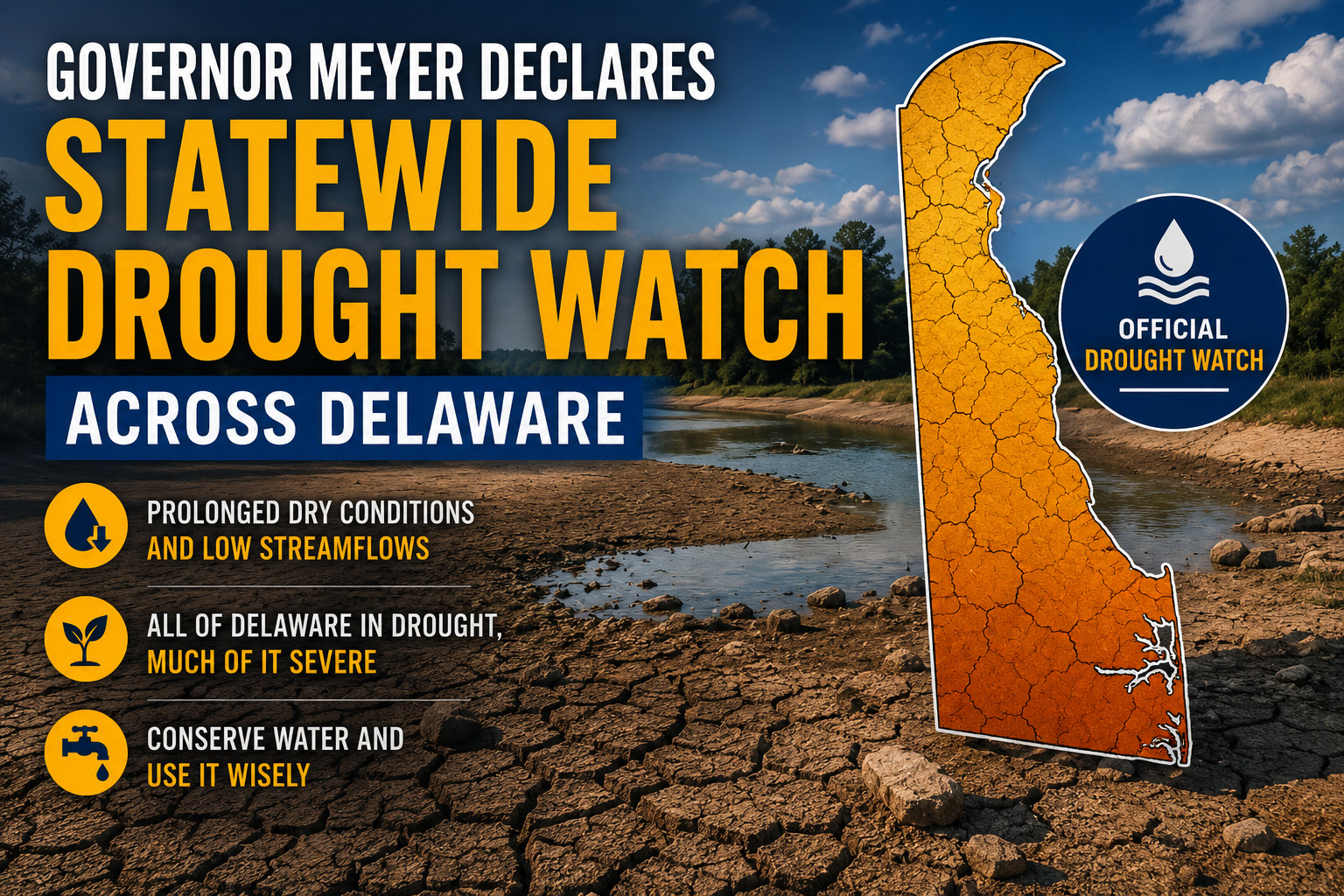
Delaware is now under a statewide drought watch following an announcement from Governor Matt Meyer, who acted on recommendations from the Delaware Water Supply Coordinating Council (WSCC).
The governor’s declaration comes as water supply officials monitor conditions across the state and provide guidance on water management measures.
DOVER, Del. — Governor Matt Meyer has issued a statewide drought watch for Delaware as dry conditions continue to worsen across the state following months of below-normal rainfall.
The declaration comes after recommendations from the Delaware Water Supply Coordinating Council, which monitors drought indicators including precipitation, streamflow, groundwater levels, reservoir storage, and soil moisture. Officials say a prolonged lack of rainfall, combined with increasing water demand from vegetation during the growing season, has led to deteriorating conditions across much of Delaware.
According to the Delaware Climate Office, the state has experienced an extended stretch of below-normal precipitation, with streamflows running well below average and groundwater levels continuing to decline. Many waterways are reporting some of their lowest levels on record for this time of year.
The drought watch is intended to raise awareness and encourage voluntary conservation measures before conditions worsen further. Residents and businesses are being asked to reduce nonessential water use whenever possible, particularly outdoor watering activities.
Current drought conditions remain widespread across Delaware. The latest data indicates that all of the state is experiencing drought conditions, with much of Delaware classified in severe drought.
State officials emphasize that a drought watch is the first stage of Delaware’s drought response plan. More serious drought warnings or emergency declarations could be considered if dry conditions persist and water supplies continue to decline.
The declaration also comes as elevated fire danger concerns continue across the state. Dry vegetation, low humidity, and periodic gusty winds have increased the risk of brush and wildfire activity during recent weeks.
Forecasters are not expecting significant widespread rainfall through the remainder of the week, which may allow drought conditions to continue or worsen heading further into June. Climate outlooks currently suggest limited opportunities for substantial drought improvement in the near term.
Officials encourage residents to monitor water usage, stay informed on changing drought conditions, and practice fire safety as Delaware enters the summer season under increasingly dry conditions.
A rare space weather event later this week could provide at least a chance for Northern Lights visibility across portions of the Mid-Atlantic, including Delmarva, as a series of powerful solar eruptions head toward Earth.
The possibility stems from multiple coronal mass ejections (CMEs) that erupted from the Sun on June 1 and June 2. CMEs are massive clouds of charged particles and magnetic fields blasted into space during periods of heightened solar activity. When these solar storms are directed toward Earth, they can interact with our planet’s magnetic field and trigger geomagnetic storms.
NOAA’s Space Weather Prediction Center has issued a G3 (Strong) Geomagnetic Storm Watch for June 4-5 as these CMEs are expected to arrive and potentially combine their effects. The collision between the solar particles and Earth’s magnetic field causes energy to be deposited into the upper atmosphere near the polar regions. This energy excites oxygen and nitrogen molecules, producing the colorful displays known as the aurora borealis, or Northern Lights.
During stronger geomagnetic storms, the auroral oval expands southward away from the Arctic, allowing residents in the northern United States and occasionally the Mid-Atlantic to witness the phenomenon.
For Delaware, Maryland’s Eastern Shore, and southern New Jersey, the odds remain lower than areas closer to the Canadian border, but they are not zero. If the incoming CMEs produce stronger geomagnetic activity than currently forecast, or if the storm briefly reaches G4 levels, a faint auroral glow could become visible low on the northern horizon.
Unlike the vibrant curtains often seen in Alaska or Canada, Delmarva observers would most likely see a subtle red, pink, or purple glow near the horizon. In some cases, smartphone cameras can reveal auroral colors and structure that are difficult to see with the naked eye.
Sky conditions will also play a major role. Fortunately, high pressure is expected to dominate the weather pattern across the Mid-Atlantic through the end of the week, bringing mostly clear skies and providing favorable viewing conditions should the aurora become visible.
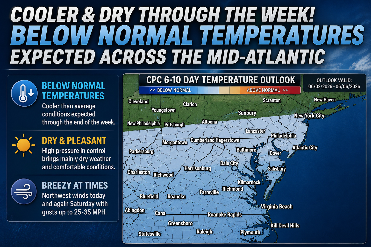
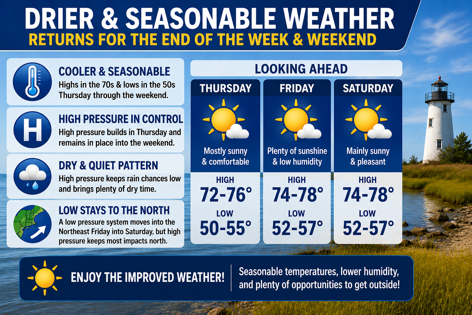
High pressure will remain firmly in control across the Mid-Atlantic through the end of the week, bringing several days of dry weather, abundant sunshine, and a gradual warming trend to the Delmarva Peninsula.
After a stretch of comfortable early June weather, temperatures are expected to steadily rise over the coming days as a large area of high pressure builds eastward from the Great Lakes and settles across the Appalachian region. While a developing area of low pressure off the Mid-Atlantic coastline will move northeastward offshore tonight, forecasters expect it to remain far enough away to have little impact on the region.
For Thursday, mostly sunny skies will dominate across Delaware, Maryland’s Eastern Shore, and southern New Jersey. Afternoon temperatures will climb into the lower and middle 80s across inland areas, including Georgetown, Salisbury, and Dover. Communities along the Atlantic coast and Delaware Bay will remain noticeably cooler, generally in the lower 70s, thanks to the influence of chilly ocean waters and developing sea breezes.
As winds shift onshore during the afternoon, some coastal locations may see temperatures drop several degrees compared to inland communities.
Tonight will feature mostly clear skies and mild conditions, with overnight lows falling into the 50s across much of the region.
Looking ahead, the dry pattern shows little sign of changing through Friday and much of Saturday. High pressure is expected to keep storm systems at bay while maintaining plenty of sunshine and low humidity levels. The only exception may be across portions of the Pocono Mountains Saturday afternoon and evening, where a slight chance of an isolated shower or thunderstorm exists.
The biggest weather story heading into the weekend will be the increasing heat. Temperatures are forecast to climb close to 90 degrees on Friday before reaching the upper 80s to lower 90s across much of inland Delmarva on Saturday. Coastal communities will once again remain cooler, with highs generally staying in the 80s due to persistent onshore flow.
The extended stretch of dry weather will provide excellent conditions for outdoor activities, beach trips, and early summer events, though residents should be prepared for increasingly warm afternoons as the weekend approaches.
TOKYO (AP) — Dangerous flooding conditions struck Japan’s capital region Wednesday as Tropical Storm Jangmi brought torrential rainfall to east-central areas of the country.
The severe weather brought street traffic to a standstill throughout the city, forced the cancellation of hundreds of airline flights, and caused significant delays and suspensions across the rail network. Power outages affected more than 5,000 households, Tokyo Electric Power Company Holdings reported.
Authorities issued evacuation advisories for residents living near the Zenpukuji River in central Tokyo. Broadcast images revealed the river’s muddy waters had risen dangerously close to overflowing its banks.
According to the Japan Meteorological Agency, Tropical Storm Jangmi was positioned east of Shima city during mid-morning hours, tracking northeast with maximum sustained winds reaching 90 kph (55 mph).
Weather officials declared the most severe flood warning level across multiple regions in central and eastern Japan, strongly advising residents in river valleys and other at-risk locations to evacuate to elevated areas immediately.
The weather system delivered 50 centimeters (20 inches) of rainfall over a 24-hour period in the Owase region of central Japan. Forecasters predicted an additional 20 centimeters (8 inches) could fall by Thursday morning across various areas, including Tokyo, according to JMA officials.
The storm initially struck Wakayama prefecture as a typhoon with winds of 126 kph (78 mph) before moving inland and losing considerable strength. Weather experts expected it to continue as a tropical storm for most of the day.
Before reaching the mainland, the typhoon passed through Okinawa’s southern island region, where it caused minor injuries to 15 individuals.
Weather authorities have extended a hazardous swimming advisory that will remain active through Sunday evening at 8:00 PM.
The National Weather Service Mount Holly office in New Jersey first issued the rip current warning on Saturday at 4:49 PM EDT, alerting beachgoers to dangerous ocean conditions.
The advisory warns swimmers and surfers about the presence of strong currents that can pull people away from shore and into deeper waters.
We are keeping a close eye on a developing area of low pressure expected to form off the East Coast during the middle of the week. While the system bears watching, current indications suggest it will remain far enough offshore to spare the Delmarva Peninsula from any significant impacts.
An upper-level trough currently moving through the Northeast is expected to become more amplified over the next several days. As this occurs, we expect the base of the trough to close off into an upper-level low pressure system somewhere near the North Carolina coast or farther northeast over the Atlantic Ocean.
As the upper-level low develops, a corresponding surface low pressure system is expected to form offshore. However, forecast guidance continues to indicate that the storm will remain well east of the Mid-Atlantic coastline.
A large area of high pressure centered over the Great Lakes and Northeast is expected to act as a blocking mechanism, preventing the storm from moving closer to land. Because of this, confidence is increasing that dry weather will continue across Delaware, Maryland’s Eastern Shore, and much of the surrounding region through the end of the workweek.
While rainfall is not expected, the offshore storm could still have a minor influence on local weather. If the low pressure system tracks slightly closer to the coast than currently forecast, northeasterly winds could develop, leading to somewhat cooler temperatures, particularly near the Atlantic beaches and Delaware Bay shoreline.
Despite that possibility, the overall forecast remains favorable with seasonable conditions expected through midweek.
Temperatures are forecast to gradually warm during the second half of the week as high pressure shifts southeastward. Afternoon highs should climb into the 80s by Thursday before potentially reaching the lower 90s across parts of Delmarva on Friday and Saturday.
The warming trend will be driven by a much warmer air mass moving into the Northeast, bringing summerlike conditions back to the region after several days of more comfortable temperatures.
Looking ahead to the weekend, there are some early indications that precipitation chances may begin to increase. However, forecast confidence remains low regarding the timing and coverage of any showers or thunderstorms.
For now, residents can expect several more days of dry weather, plenty of sunshine, and a gradual return to hotter temperatures heading into the first weekend of June.
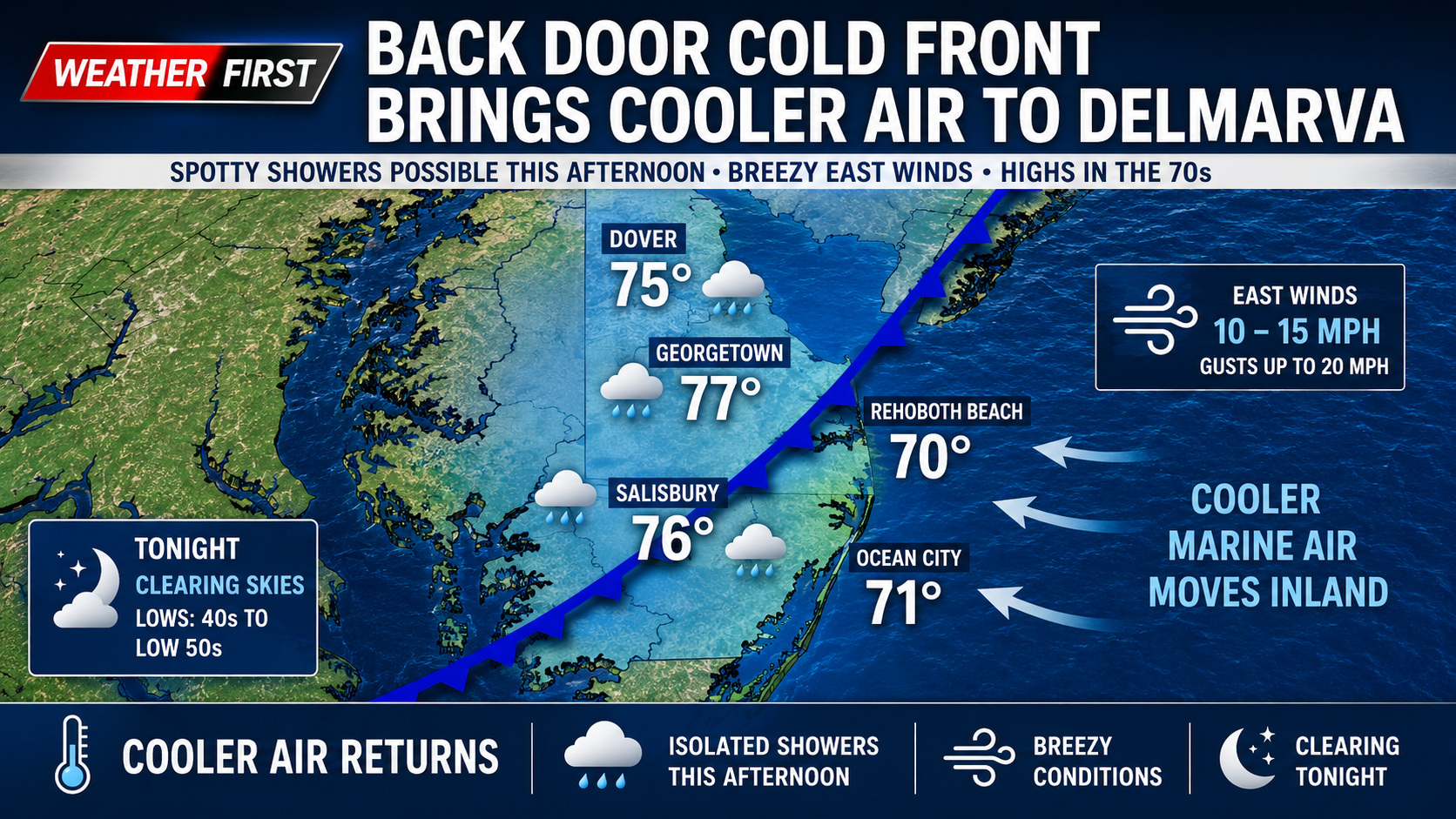
A pair of weak cold fronts will move through the Delmarva Peninsula today, bringing a shift in winds, slightly cooler temperatures, and the possibility of a few isolated showers.
The first cold front moved through the region during the early morning hours as a weak area of low pressure tracked across the Mid-Atlantic. While no rainfall accompanied the front, residents may notice changing wind directions throughout the day. Winds that began from the south overnight will gradually shift to the southwest, northwest, and eventually north as the front exits the area.
Attention then turns to a second feature known as a back door cold front, which will slide southward through Delmarva this afternoon. Unlike a traditional cold front that approaches from the west, a back door front moves in from the northeast, allowing cooler marine air from the Atlantic Ocean to spread inland.
The combination of increasing onshore flow and a weak disturbance in the middle levels of the atmosphere could be enough to trigger a few isolated light showers across portions of Delaware, Maryland’s Eastern Shore, and southern New Jersey. However, rainfall amounts are expected to remain minimal, with many locations receiving only a trace of precipitation. Any areas that do see measurable rain will likely receive no more than a few hundredths of an inch.
East winds will increase to around 10 to 15 mph during the afternoon, with occasional gusts reaching 20 mph. Temperatures will remain seasonable for early June, with afternoon highs reaching the middle to upper 70s across much of Delmarva. Communities along the Delaware and Maryland beaches will remain cooler due to the onshore flow.
Conditions improve tonight as skies gradually clear behind the departing front. The cooler air mass will allow temperatures to fall into the 40s and lower 50s by daybreak Tuesday, providing a crisp and comfortable night across the region.
While today’s weather will not be a washout, residents may encounter a brief passing shower this afternoon before drier and pleasant conditions return tonight.
After months of growing drought concerns across portions of the Mid-Atlantic and Northeast, this week’s U.S. Drought Monitor update shows meaningful improvement in several areas following widespread soaking rainfall and cooler temperatures.
A highly active weather pattern during the past week delivered multiple rounds of heavy rain from the southern Plains through the Mid-Atlantic states. Across parts of Maryland, West Virginia, and southern Pennsylvania, many communities received between 2 to 4 inches of rainfall, with isolated areas picking up even higher totals.
The beneficial rainfall came as a strong cold front pushed through the eastern United States, ending an early season heat wave and replacing it with a much cooler and unsettled weather pattern. The combination of steady stratiform rain and convective downpours helped improve soil moisture conditions and increase streamflows across much of the region.
As a result, the latest drought monitor introduced widespread drought reductions across portions of the Mid-Atlantic. Areas of Maryland, West Virginia, and southern Pennsylvania saw notable improvements, especially in locations where rainfall totals exceeded 3 inches during the week.
Despite the recent improvement, experts caution that long term drought impacts have not fully disappeared. Groundwater supplies and reservoir levels remain below normal in some locations after months of persistent dryness. While short term drought indicators such as soil moisture and recent precipitation trends have improved significantly, longer term indicators continue to show lingering deficits.
Because of this, drought classifications across parts of Pennsylvania and Maryland were adjusted from both short and long term drought to primarily long term drought concerns. This reflects improving near surface conditions while acknowledging that deeper hydrological impacts remain in place.
Further north across New England, modest improvements were observed in portions of Maine and Vermont due to improving groundwater conditions. However, drier weather in southeastern New England led to some worsening conditions across parts of Rhode Island and eastern Massachusetts.
Across the broader eastern United States, the same storm system also brought widespread drought relief to portions of the Southeast. Heavy rainfall totals ranging from 2 to 6 inches fell across parts of Mississippi, Alabama, Georgia, and the Florida Panhandle, leading to additional drought reductions in those regions as well.
Looking ahead, forecasters expect a quieter weather pattern to settle over the Mid-Atlantic heading into early June. While additional scattered rainfall opportunities may develop next week, no major widespread flooding or drought busting rainfall events are currently anticipated.
Even with recent improvements, drought recovery is often a slow process. Hydrologists and agricultural experts will continue monitoring groundwater recharge, reservoir recovery, and longer term precipitation trends throughout the summer season.
After several rounds of unsettled weather across the Mid-Atlantic in recent weeks, a much calmer and more comfortable stretch of weather is now expected across Delmarva heading into the start of meteorological summer.
A cold front moving through the region early Thursday morning is bringing a few lingering showers to portions of southern Delaware and South Jersey. Those showers are expected to quickly move offshore around daybreak as drier air pushes into the region from the northwest.
Behind the front, high pressure will build into the Mid-Atlantic and dominate the weather pattern through much of the upcoming week. The result will be several days of tranquil conditions featuring comfortable humidity levels, cooler overnight temperatures, and seasonable daytime highs mainly in the middle to upper 70s.
While the overall pattern remains quiet, breezy northwest winds are expected at times. Wind gusts Thursday afternoon could reach 20 to 30 mph, especially closer to the coastline and open areas. Another dry cold front is forecast to move through Friday night, which may bring another round of gusty winds for Saturday with gusts potentially reaching 25 to 35 mph. Despite the breezy conditions, no widespread rainfall or severe weather is expected with the frontal passage.
We are also monitoring the development of a large scale “Omega Block” weather pattern across the central United States. This pattern tends to slow down weather systems and promote more stable conditions. Delmarva will remain on the eastern side of this blocking pattern, helping keep temperatures slightly below normal through the weekend while also limiting any major storm development.
Looking ahead into next week, forecast confidence becomes lower as a disturbance may attempt to cut off near the East Coast. This could eventually introduce a more unsettled pattern with increased cloud cover or scattered showers at times. However, current indications suggest the risk for any hazardous or impactful weather remains very low.
Weather officials have issued a severe thunderstorm warning that went into effect at 11:58 AM EDT on May 27th and will remain active until 1:00 PM EDT the same day.
The alert was issued by the National Weather Service office in Mount Holly, New Jersey, as meteorologists monitor dangerous weather conditions in the region.
Residents should stay alert for potential severe weather conditions and take appropriate safety precautions during the warning period.
Weather officials from the National Weather Service Mount Holly office in New Jersey issued a severe thunderstorm warning on Monday, May 27th.
The warning went into effect at 11:20 AM Eastern Daylight Time and was scheduled to expire at 12:00 PM EDT the same day.
The alert was distributed through the National Weather Service’s official warning system to notify residents of potentially dangerous weather conditions in the affected area.
A more active weather pattern is expected to unfold across the Mid Atlantic today as a disturbance moving out of the Great Lakes pushes toward the Ohio Valley and East Coast. Forecasters are monitoring the potential for scattered strong to severe thunderstorms this afternoon and evening, especially across portions of Maryland, Delaware, Virginia, and southern Pennsylvania.
An upper level trough currently swinging southeast through the Great Lakes will help provide the energy needed for thunderstorm development later today. Early morning satellite and water vapor imagery already showed a lead disturbance tracking across southern Ohio into the central Appalachians, helping to spark areas of showers and thunderstorms ahead of the main system.
At the surface, a frontal boundary draped across the region has been reshaped by ongoing morning rainfall and thunderstorms. As this boundary gradually slides southeast through the day, warm and humid air ahead of it will continue building instability across the Mid Atlantic. Dewpoints climbing into the upper 60s and lower 70s will create a very moisture rich atmosphere capable of supporting stronger storms by this afternoon.
Clusters of thunderstorms to develop and move east southeastward later today. The primary threat with the strongest storms will be damaging wind gusts ranging from 50 to 65 mph, capable of bringing down tree limbs and causing isolated power outages. Some of the more intense storm cores may also produce small to marginally severe hail.
While widespread severe weather is not expected, scattered strong storms could become locally intense during the peak heating hours this afternoon into early evening. Residents across the region should stay alert for rapidly changing weather conditions and be prepared for possible severe thunderstorm warnings later today.
In addition to the wind threat, locally heavy rainfall may also accompany stronger storms given the humid environment already in place across the region.
Transportation authorities have implemented a temporary speed reduction on Interstate 495, lowering the maximum allowed speed to 55 miles per hour due to current weather conditions.
The speed restriction has been put in place as a safety precaution to help drivers navigate the interstate more safely during adverse weather.
Motorists traveling on I-495 are advised to observe the reduced speed limit and exercise additional caution while driving in the current weather conditions.
A threat for strong to locally severe thunderstorms is expected to develop across portions of the Mid Atlantic on Wednesday as a potent upper level disturbance tracks across the northeastern United States.
According to the latest forecast discussion from the Storm Prediction Center, a strong shortwave trough moving southeast across Ontario and into the Northeast will help trigger scattered thunderstorms from the Ohio Valley eastward into Maryland, Delaware, and Virginia during the afternoon and evening hours Wednesday.
A warm, humid, and moderately unstable air mass is expected to be in place across much of the region ahead of an approaching surface boundary stretching from the Ohio Valley into the Delmarva Peninsula. As daytime heating develops, scattered thunderstorms are expected to form and organize along and south of the boundary.
The main severe weather threat will be damaging wind gusts, especially within more organized clusters of thunderstorms capable of producing strong downdrafts. Steep low level lapse rates combined with moderately strong winds just above the surface may allow some storms to transfer stronger winds down to ground level.
Across the Delmarva region, the greatest severe weather potential currently appears to be during the afternoon into the early evening hours Wednesday. While widespread severe weather is not expected at this time, isolated storms could become strong enough to produce locally damaging wind gusts and brief heavy downpours.
The threat level and storm coverage will depend heavily on how much instability can develop during the day, which will be influenced by cloud cover and any lingering showers from earlier in the day.
Residents across the Mid Atlantic and Delmarva Peninsula are encouraged to stay weather aware Wednesday afternoon and evening as conditions may become favorable for a few severe thunderstorms capable of producing isolated wind damage.
After several days of unsettled weather and scattered showers across the Delmarva Peninsula, a much quieter weather pattern is expected to settle into the region heading into the end of the week and the upcoming weekend.
A cold front moving through Wednesday night will usher in slightly cooler and less humid air for Thursday, with comfortable conditions expected to persist through the weekend. High temperatures across Delmarva are forecast to remain mainly in the 70s during this period, while overnight lows fall back into the 50s, offering a refreshing change compared to the recent stretch of warmer and wetter weather.
High pressure is forecast to gradually build into the Mid Atlantic on Thursday and remain the dominant weather feature through the weekend. This area of high pressure should provide mainly dry conditions, lower humidity levels, and intervals of sunshine across Delaware, Maryland’s Eastern Shore, and coastal Virginia.
While another low pressure system is expected to track into the Northeast Friday into Saturday, the strengthening high pressure system over the Delmarva region is expected to keep most of the storm activity well to the north. Forecast guidance continues to support a mainly dry forecast locally with minimal impacts expected from the passing system.
Overall, the weather pattern heading into the weekend looks much more favorable for outdoor activities across Delmarva, with seasonable temperatures, lower humidity, and reduced rain chances expected through at least Sunday.
An unsettled stretch of weather will continue across the Delmarva region through midweek, although conditions are expected to improve somewhat compared to the soggy Memorial Day weekend.
A stationary front remains draped across the region Tuesday morning and will slowly drift southward through the day. While a few showers remain possible, especially across southern portions of Delmarva, much of the region is expected to stay dry for much of today. Especially across the northern tier. Some breaks of sunshine may also develop during the afternoon, helping temperatures climb into the upper 70s to near 80 degrees.
The front is forecast to stall directly across Delmarva tonight into Wednesday as an area of low pressure rides along it. This setup will bring additional rounds of scattered showers to the region Tuesday night through Wednesday. The greatest coverage of rain is expected across southern Delmarva, where rainfall totals could reach around one half inch or locally higher by the time the system exits.
Northern portions of Delmarva may see lighter rainfall amounts, generally ranging from a few hundredths to around a quarter inch. Despite the continued wet pattern, no significant flooding or severe weather impacts are currently anticipated.
Temperatures on Wednesday will remain seasonable, with highs once again hovering around 80 degrees under mostly cloudy skies and periods of showers.
A cold front arriving Wednesday night will finally sweep the lingering moisture offshore, allowing a transition toward drier, quieter, and more comfortable weather for the latter half of the week across the Delmarva Peninsula.
Visibility issues are affecting drivers across Sussex County as dense fog conditions have been observed in several locations throughout the area.
The weather phenomenon is creating hazardous driving conditions for motorists traveling through the affected regions. Drivers are advised to reduce speed, use low-beam headlights, and maintain increased following distances when encountering these foggy conditions.
Weather conditions can change rapidly, and additional areas may experience similar visibility challenges as atmospheric conditions continue to develop.
Emergency crews fought a grass blaze in Edinburgh while temperature records fell across Western Europe as an unseasonably intense heat wave swept through the region, prompting government health warnings.
The British capital experienced an unusual “tropical night” where temperatures stayed above 20 Celsius (68 Fahrenheit), with weather officials predicting southern England could see temperatures reach 35 C (95 F) on Tuesday.
Tragedy struck when a 13-year-old boy lost his life after encountering trouble in a reservoir in Halifax, northern England, on Monday, according to police reports.
Across the channel in France, May temperature records have been shattered as readings climbed well above 30 C (86 F) throughout much of the nation.
Government spokeswoman Maud Bregeon reported at least seven deaths potentially connected to the extreme heat, including five drowning incidents and two fatalities during athletic events.
The United Kingdom set a new May temperature record on Monday when thermometers hit 34.8 C at Kew Gardens in London, crushing the previous mark of 32.8 C (91.4 F) established in 1922 and 1944.
Following a holiday weekend that drew crowds to coastlines, swimming areas and shaded green spaces, London travelers endured sweltering conditions Tuesday in subway cars without air conditioning. Rail service to and from the capital’s major Waterloo hub faced delays due to reports of smoke on railway lines.
Emergency responders worked overnight to extinguish flames that created massive smoke clouds rising from Arthur’s Seat, the prominent rocky formation overlooking Edinburgh.
Health officials issued an amber warning for most of the country lasting through Wednesday morning, cautioning about potential health dangers, especially for older residents, during peak heat hours. Since moderate climates are typical for the region, many residences, educational facilities and workplaces lack cooling systems.
The unseasonable heat wave arrived before the summer period when trained lifeguards typically monitor swimmers at busy coastal areas, creating additional safety concerns.
Along France’s Atlantic coastline, where beautiful beaches also feature dangerous currents, authorities documented numerous water emergencies including two drowning fatalities on Sunday at well-known vacation spots in the southwestern Gironde area.
The region’s top administrator, Sophie Brocas, called on beach visitors “to exercise the utmost caution.”
Unpredictable and severe weather patterns are occurring more often as global temperatures continue rising. Climate specialists warn that unprecedented and dangerous weather events that sometimes occur during unusual seasons and in unexpected locations are placing more people at risk.
Extreme temperatures are gripping Europe during an unusual May heat wave that’s breaking long-standing records, including new highs set in the United Kingdom on Monday, while government officials issue safety alerts following fatalities at recreational sporting events in France.
Marina Ferrari, the French sports minister, expressed sympathy for the family of a participant who died Sunday during a running event in Paris. According to Le Parisien newspaper, the 53-year-old man went into cardiac arrest while running in the capital’s 20th arrondissement, and emergency responders could not save him.
While officials have not confirmed whether the runner’s death was connected to the heat, Ferrari indicated there may be a correlation.
“The events that occurred today (Sunday) during running races are a reminder that practicing sports in extreme heat requires absolute vigilance,” Ferrari said in an X post. “My thoughts are with the family and loved ones of the runner who died in Paris, as well as with the people who were treated by emergency services.”
Meanwhile, in Lyon, a southeastern French city, local news outlet Actu Lyon reported Monday that a woman died from heat stroke during a separate athletic competition, also occurring on Sunday.
Meteo France, the country’s weather monitoring agency, confirmed that temperatures are setting new May records, climbing above 30 C (86 F) across much of France with forecasts showing the heat continuing through the week.
Britain established a new May temperature record on Monday following the declaration of a heat wave across multiple regions of the country.
People and visitors flocked to coastal areas and parks while seeking shade during the holiday as temperatures reached 33.5 C (92.3 F) at London’s Heathrow Airport, surpassing the previous May record of 32.8 C (91.4 F) established in 1922 and equaled in 1944.
The U.K. Health Security Agency has announced its first amber health warning of the year, cautioning about increased mortality risks, especially among elderly populations, during peak heat periods.
Climate scientists note that extreme weather events are becoming more common as global warming intensifies. Researchers warn that unprecedented and dangerous weather patterns that can occur during unexpected seasons and in atypical locations are exposing more populations to risk.
After a stretch of unsettled weather featuring showers, thunderstorms, and periods of heavy rain, a gradual return to drier and more seasonable conditions is expected across Delmarva and the Mid-Atlantic through the second half of the week.
A cold front moving south of the region Tuesday will help push the more humid and stormy pattern away from the area, although the boundary is expected to linger nearby. Because of its close proximity, scattered showers may still develop at times Tuesday, especially across southern New Jersey and portions of the Delmarva Peninsula.
Temperatures Tuesday will remain fairly mild with afternoon highs generally reaching the mid 70s to low 80s inland, while communities closer to the Atlantic coast experience cooler conditions due to onshore flow and marine influences.
Another cold front is forecast to slide southward through the region on Wednesday. However, this secondary front appears moisture-starved and is not expected to produce widespread rainfall. A stray shower cannot be ruled out, particularly across Delmarva where lingering moisture near the stalled frontal boundary to the south could spark a few additional afternoon showers.
Despite the slight shower chances, temperatures Wednesday will trend a bit warmer with highs climbing into the upper 70s to middle 80s away from the coast. Shore communities will once again stay cooler due to persistent easterly winds off the Atlantic Ocean.
The overall weather pattern becomes much more favorable heading into Thursday and Friday as high pressure builds into the region from the north and west. This will allow for increasing sunshine, lower humidity levels, and more comfortable late May conditions across the Mid-Atlantic.
High temperatures both Thursday and Friday are expected to settle into the 70s region-wide, providing a refreshing change following the recent active and humid weather pattern.
By the end-of-week stretch should offer some of the most pleasant weather the region has experienced in recent days, with lower rain chances and more stable atmospheric conditions expected heading into next weekend.
A messy and unsettled weather pattern will continue across the Mid-Atlantic and Delmarva region today as multiple fronts and areas of low pressure move through the area, bringing periods of showers, thunderstorms, patchy fog, and the potential for locally heavy rainfall.
Early this morning, a warm front began lifting northward across the region ahead of a strengthening area of low pressure tracking through the eastern Great Lakes and Ohio Valley. This setup has already produced areas of patchy fog, drizzle, low clouds, and light rain across portions of eastern Pennsylvania, New Jersey, Delaware, and Maryland.
As the warm front continues northward through the morning hours, a band of showers moving east out of western Pennsylvania and New York will begin interacting with the increasingly humid and unstable air mass across the region. This interaction could lead to the development of thunderstorms capable of producing torrential downpours and localized flooding concerns.
The first round of heavier showers and thunderstorms is expected to develop from the southern Poconos and Lehigh Valley eastward toward the Interstate 95 corridor during the late morning into early afternoon. Additional storms are then expected to redevelop later this afternoon and evening as a cold front sweeps through the region.
The greatest concern for Delmarva appears to arrive later today into tonight, when thunderstorms are forecast to intensify across southern New Jersey and the Delmarva Peninsula. Some of the stronger storms may produce gusty winds, frequent lightning, and pockets of heavy rainfall that could lead to poor drainage flooding in low-lying and urban areas.
Despite the clouds and rainfall, temperatures will still climb into the low to mid 70s this afternoon as warmer air spreads northward ahead of the cold front.
Patchy fog and low clouds may redevelop tonight behind the front as lingering moisture remains trapped near the surface.
Residents across the region are encouraged to remain weather aware through the day, especially during periods of heavy rain and thunderstorms that could quickly reduce visibility on area roadways.
The National Weather Service office in Mount Holly, New Jersey has issued a rip current advisory that went into effect Friday at 5:39 PM and will remain active until Saturday at 8:00 PM.
Beach visitors are urged to use extreme caution when entering ocean waters during this time period due to the elevated risk of dangerous rip currents.
Rip currents are powerful, narrow channels of fast-moving water that can quickly pull swimmers away from shore and into deeper waters, making them extremely hazardous for beachgoers of all swimming abilities.
Weather officials have issued a high surf advisory for coastal Delaware areas, warning residents and beachgoers of dangerous conditions along the shoreline.
The National Weather Service Mount Holly office issued the advisory at 3:16 AM on May 24th, with conditions expected to persist until 8:00 AM the same morning.
Residents are advised to exercise caution near coastal areas during the advisory period as elevated surf conditions may create hazardous situations for swimmers and those walking along the beach.
Weather officials have issued a high surf advisory for the Delaware coast, warning residents and beachgoers of potentially dangerous conditions.
The National Weather Service office in Mount Holly, New Jersey, issued the advisory on Thursday, May 23rd at 4:03 PM EDT. The warning remains in effect until Friday, May 24th at 8:00 AM EDT.
The advisory alerts the public to hazardous surf conditions that could pose risks to swimmers, surfers, and anyone near the water along Delaware’s shoreline.
Beachgoers are urged to exercise extreme caution during this period and stay aware of changing ocean conditions.
The National Weather Service office in Mount Holly, New Jersey has issued an advisory warning of dangerous rip current conditions affecting coastal areas.
The safety alert went into effect early this morning at 2:24 AM and will remain active until 8:00 PM today, May 23rd.
Beachgoers are urged to exercise extreme caution when entering ocean waters during this period, as rip currents pose serious risks to swimmers of all skill levels.
Rip currents are powerful, narrow channels of fast-moving water that can quickly pull swimmers away from shore and into deeper waters.
Weather authorities have put a high surf advisory into effect for coastal areas, warning residents and beachgoers of potentially dangerous wave conditions.
The advisory went into effect at 2:24 AM on May 23rd and will continue until 8:00 AM on May 24th, according to the National Weather Service Mount Holly office in New Jersey.
The warning indicates that wave heights and surf conditions could pose risks to those near the shoreline during this timeframe.
Weather officials have issued a high surf advisory for coastal areas, effective from Wednesday afternoon through Friday morning.
The National Weather Service office in Mount Holly, New Jersey issued the advisory on May 22 at 3:54 PM EDT, with conditions expected to persist until May 24 at 8:00 AM EDT.
Residents and visitors in affected coastal areas should exercise caution near the water during this period.
Federal weather experts are predicting a calmer Atlantic hurricane season this year, crediting a strengthening El Nino weather pattern that typically suppresses storm development in the region.
The National Oceanic and Atmospheric Administration released its seasonal prediction Thursday, indicating a 55% probability of below-normal hurricane activity. Weather officials anticipate eight to 14 named storms this season, with three to six reaching hurricane strength and one to three becoming major hurricanes.
Typical hurricane seasons produce 14 named storms, with seven reaching hurricane status and three becoming major hurricanes with winds exceeding 110 mph.
Eighteen additional forecasting organizations from private companies and universities have issued similar predictions, with most calling for reduced activity during the summer and fall months. These independent forecasts project an average of 12 named storms, with only five becoming hurricanes and two reaching major hurricane classification. These predictions also suggest the Accumulated Cyclone Energy index will register at 80% of typical levels.
Colorado State University, which began hurricane seasonal predictions in 1984, expects the lowest storm activity since 2015, when the strongest El Nino in 75 years occurred. The university’s hurricane specialist Phil Klotzbach indicated their forecast may be revised downward in June.
This prediction comes after nine of the past 10 Atlantic hurricane seasons exceeded normal activity levels or reached hyperactive status, Klotzbach noted. Last season began slowly but intensified later, generating a near-record three Category 5 hurricanes, including Melissa, which caused extensive damage to Jamaica and Cuba, according to Columbia University climate scientist and tropical weather specialist Suzana Camargo.
Global economic losses from tropical storms have climbed dramatically, rising from an average of $11.4 billion annually in the 1980s to $109.7 billion per year over the last decade, with three-quarters of the damage occurring in the Atlantic, Gulf of Mexico and Caribbean regions, according to insurance company Munich Re.
Weather experts note that hurricanes, typhoons and cyclones represent the same meteorological phenomenon, with different names used across various global regions.
“We should expect a less active year than certainly what we’ve seen recently, and perhaps significantly so below average,” said University at Albany atmospheric scientist Kristen Corbosiero. “But again, it only takes one to cause real devastation and destruction in the mainland U.S. or even in Hawaii.”
The primary factor driving these predictions is “the elephant in the room” – the developing El Nino, Camargo explained.
El Nino represents a natural, cyclical warming of central Pacific waters that disrupts global weather patterns, particularly during winter months. Researchers have documented for decades the relationship between El Nino conditions and reduced Atlantic hurricane activity, while simultaneously increasing storm frequency and intensity in the central and eastern Pacific. Many forecasters this year are predicting a strong, superstrong or potentially record-breaking El Nino. During La Nina conditions – El Nino’s cooler counterpart – the Atlantic typically experiences increased storm activity.
NOAA Administrator Neil Jacobs stated Thursday that there’s a 98% probability of El Nino conditions this summer, with an 80% chance of moderate to strong intensity.
Historical data shows that Atlantic hurricane seasons during strong or very strong El Nino events produce two-thirds the number of named storms and half the hurricanes compared to the 1991-2020 average, based on Associated Press analysis of storm and El Nino records.
El Nino conditions inhibit Atlantic storm development through multiple mechanisms, particularly through crosswinds occurring one to seven miles above the surface “which can basically blow apart the thunderstorms that make up” a hurricane, Corbosiero explained.
“A stronger than normal wind shear tends to tilt storms as they try to develop,” said University at Albany atmospheric scientist Brian Tang. “It pushes dry air into storms. And prevents storms from developing in the first place. And if they do develop, it also prevents them from intensifying.”
While El Nino reduces both frequency and intensity of weaker storms, once systems reach hurricane status with 74 mph winds, “they can be kind of like a self-feeding entity” and become less susceptible to El Nino’s wind shear effects, explained Matthew Rosencrans, lead hurricane season forecaster with NOAA’s National Weather Service.
Peak season forecasts indicate strong westerly wind shear in the main development region where the largest and longest-lasting hurricanes typically form off Africa before moving west across the Atlantic, Klotzbach noted. El Nino conditions typically reduce these types of storms.
During the 15 strongest El Nino years since 1950, 37 named storms, 11 hurricanes and three major hurricanes made landfall on the continental United States. In contrast, during the 15 coldest La Nina years, 61 named storms, 31 hurricanes and 10 major hurricanes struck America’s Gulf and Atlantic coastlines, according to Klotzbach. He noted that El Nino primarily reduces Atlantic coast impacts while having less influence on Gulf coast landfalls.
Beyond El Nino, dry African conditions and Atlantic water temperatures only slightly above normal also contribute to forecasts of reduced seasonal activity, Rosencrans said.
El Nino and La Nina patterns create opposite effects on Pacific storms compared to Atlantic systems, leading experts to anticipate increased Pacific activity. Jacobs predicted a 70% chance of above-normal eastern Pacific hurricane activity.
NOAA forecasts 15 to 22 named Pacific storms with nine to 14 becoming hurricanes and five to nine reaching major hurricane status. Normal Pacific activity includes 15 named storms, eight hurricanes and four major hurricanes. Rosencrans explained that central Pacific storm development typically shifts closer to Hawaii during El Nino periods.
Eastern Pacific storms near Baja Mexico typically “go west, affect the fishies and little else,” Corbosiero said. However, they occasionally turn east or north, causing significant damage like Hurricane Otis in 2023, which devastated Mexico, or 1992’s Hurricane Lester, which brought heavy rainfall to the U.S. Southwest.
Hawaii’s small island chain in the vast Pacific remains vulnerable to storm threats. In 1992, an El Nino year with minimal Atlantic activity (though Miami suffered devastation from Hurricane Andrew), Hawaii was struck by Hurricane Iniki.
Moving westward toward Asia and India, “your odds of any storm forming becoming a super typhoon go up significantly in El Nino,” Klotzbach said.
The eastern Pacific hurricane season began May 15, while the Atlantic season starts June 1, with both concluding November 30.
El Nino conditions can extend hurricane seasons, explained John Bravender, a weather service meteorologist in Honolulu. “With the warmer waters across the area, not only can hurricanes maintain their strength at higher latitudes, but also longer through the year,” he said.
Hawaii is preparing for potential hurricane impacts while parts of the state continue recovering from recent consecutive storms that caused catastrophic flooding, Gov. Josh Green said.
Delaware transportation officials have implemented a temporary speed reduction on Interstate 495, lowering the limit to 55 miles per hour due to hazardous wet weather conditions affecting the roadway.
The Delaware Department of Transportation announced the precautionary measure as rain continues to create slippery and potentially dangerous driving conditions along the interstate corridor.
Motorists traveling on I-495 are advised to reduce their speed and exercise additional caution while the wet weather persists. The temporary speed limit adjustment is designed to help prevent accidents and ensure driver safety during the challenging road conditions.
The speed restriction will remain in place until weather conditions improve and normal driving conditions return to the interstate.
With the Atlantic hurricane season set to begin June 1, Sussex County emergency management officials are reminding residents to start their storm preparations now, regardless of what forecasters predict for the coming months.
The Sussex County Department of Public Safety/Division of Emergency Management is emphasizing the importance of readiness as communities prepare for summer activities including 250th anniversary independence celebrations and beach gatherings.
Timothy Cooper, Sussex County emergency manager, stressed that residents shouldn’t get caught up in seasonal predictions. “There’s a tendency each year to focus heavily on forecasts, and while it’s great this captures public attention, we want the public to focus on readiness in general, regardless of the predictions,” Cooper explained. “Don’t focus so much on the number of predicted storms, or the forecasted intensity. The effects could be just as damaging and deadly if a tropical storm became stationary. All it takes is one storm, so the message is to be prepared at all times for any scenario. Make a plan, create a kit, stay informed, and get engaged.”
Sussex County, like other coastal areas from the Caribbean to Canada, faces risks from tropical weather including flooding and strong winds. The county experienced no direct impacts from tropical systems during the 2025 season, as storms tracked away from the area.
Last year’s Atlantic hurricane season was slightly below average, producing 13 named storms with five becoming hurricanes. Four of those reached major hurricane status and caused billions in damage.
For 2026, the National Oceanic and Atmospheric Administration forecasts another below-normal season with eight to 14 named systems expected. Three to six could strengthen into hurricanes, with one to three potentially reaching Category 3 intensity or higher, according to NOAA’s May 21 forecast. A strong El Niño pattern is expected to influence this season.
El Niño conditions typically reduce Atlantic hurricane development, leading to average or below-average seasons. During this phase, warmer waters in the equatorial eastern Pacific create atmospheric conditions that produce wind shear and inhibit storm formation. The opposite occurs during La Niña years when cooler Pacific waters can lead to increased Atlantic hurricane activity.
Based on NOAA’s 30-year average, a typical Atlantic hurricane season produces 14 named storms, seven hurricanes, and three major hurricanes.
Emergency officials emphasize that preparation remains crucial regardless of seasonal forecasts, as a single storm can cause devastating impacts.
Residents can enhance their safety by creating a household Safety Profile through the free Smart911™ service, which provides first responders with potentially life-saving information. Users can include property details, medical conditions, and family contact information.
Officials recommend several key preparation steps for hurricane season:
Residents in flood-prone or vulnerable areas should prepare evacuation plans now. Emergency managers will announce evacuation areas and timing through media outlets. Those evacuating should take storm kits, valuable papers, secure their homes by locking doors and windows, shut off utilities, and notify family members outside the evacuation zone of their destination.
Property owners should secure outdoor items and boats, clear gutters and rainspouts, and trim trees that could pose hazards during high winds.
Every family should assemble a disaster kit containing: a three-day water supply (one gallon per person daily), non-perishable food and manual can opener, clothing and shoes for each person, prescription medications, blankets or sleeping bags and pillows, personal hygiene items, flashlights and extra batteries for each person, special needs items like baby formula and supplies for elderly or disabled family members, portable radio with extra batteries, cash for when ATMs don’t work during power outages, and fuel since gas pumps also fail during outages.
When storms approach, travel during daylight and don’t wait until the last minute for supplies or gasoline. Monitor storm updates on radio and television when watches are issued, as evacuations may need to begin 24 to 36 hours before a storm arrives.
Those ordered to evacuate should follow local emergency managers’ instructions on shelter locations and timing. Authorities will announce shelter sites in advance, potentially opening multiple locations for larger populations.
Residents not ordered to evacuate who shelter at home should prepare disaster kits, keep important documents in waterproof containers in the highest, safest location, secure homes by locking doors and windows, turn off utilities, monitor portable radio for updates, stay indoors in interior rooms away from doors and windows.
Phone use should be limited to essential calls kept brief, with emergencies reported to 911. When calling for help, identify yourself and location clearly and calmly. Keep mobile phones charged, though cell service may be interrupted during and after storms.
Hurricanes and tropical storms can cause severe damage including polluted water, communication failures, power outages, sewer backups, foundation damage, beach erosion, and extensive property and road damage.
After storms pass, residents shouldn’t return until authorities give clearance. Upon re-entry, watch for hazards like downed trees and power lines, debris and standing water on roads. Have identification and legal documents ready to prove residency. Continue using emergency water supplies or boil water until officials confirm drinking water safety, and take fire prevention precautions.
Additional hurricane preparation information, including Know Your Zone evacuation maps, preparedness materials, and volunteer opportunities with Community Emergency Response Teams or amateur radio operators, is available at Sussex County’s hurricane website at www.sussexcountyde.gov/hurricane-information, PrepareDE’s site at www.preparede.org, and NOAA Weather Ready Nation at www.weather.gov/wrn/.
NOAA is forecasting a below normal 2026 Atlantic hurricane season, citing the expected development of El Niño conditions during the peak of the season as a major factor that could suppress tropical activity across the Atlantic Basin. Despite the quieter outlook, forecasters continue to stress that it only takes one storm impacting land to make a season devastating.
According to NOAA’s Climate Prediction Center, the 2026 Atlantic hurricane season is expected to produce between 8 and 14 named storms, with 3 to 6 hurricanes and 1 to 3 major hurricanes reaching Category 3 strength or higher. NOAA says there is a 55% chance of a below normal season, a 30% chance of a near normal season, and only a 15% chance of an above normal season.
The primary reason behind the reduced forecast is the anticipated transition into a moderate to potentially strong El Niño pattern later this summer and fall. El Niño typically increases upper level wind shear across the tropical Atlantic, which disrupts thunderstorm organization and makes it more difficult for tropical systems to strengthen into hurricanes.
While El Niño may help limit overall storm development, forecasters caution that sea surface temperatures across portions of the Atlantic remain warmer than average, which could still support tropical activity. Additionally, NOAA emphasized that seasonal outlooks do not predict where storms will track or whether any hurricanes will make landfall in the United States. Even below average hurricane seasons have historically produced catastrophic impacts along the Gulf Coast and East Coast.
The Atlantic hurricane season officially begins June 1 and runs through November 30, with climatological peak activity typically occurring from late August through September. On average, the Atlantic Basin sees around 14 named storms, 7 hurricanes, and 3 major hurricanes each season based on the 1991-2020 climate averages.
NOAA’s outlook closely aligns with several other preseason forecasts released by Colorado State University and other meteorological organizations earlier this spring, many of which also predicted near to below average activity due to the growing likelihood of El Niño development.
As many across the Mid-Atlantic prepare for the Memorial Day holiday weekend, the weather pattern is turning much cooler, wetter, and increasingly unsettled as several rounds of showers and periods of rain are expected from late this week through at least Memorial Day itself.
A cold front moving through the region will settle and eventually stall just south of the area heading into the weekend. This stalled boundary will act as a focus for multiple waves of low pressure and disturbances to ride along it, bringing repeated chances for showers and rain across the Mid-Atlantic from Thursday through the holiday weekend.
The wettest period currently appears to be later Friday into Saturday as a more organized area of low pressure develops well to the west of the region. At the same time, high pressure building across the Northeast will wedge cooler marine air southwestward into the Mid-Atlantic, creating a classic cool air damming setup east of the Appalachians. This pattern will help keep skies cloudy, temperatures below normal, and rainfall persistent at times.
We are also monitoring the potential for locally heavy rainfall, especially Saturday, as atmospheric moisture levels rise significantly. Forecast precipitable water values, or PWATs, are expected to climb between 1.50 and 1.90 inches, which is near climatological maximum levels for late May. While widespread flooding is not currently expected, there is at least a marginal risk for excessive rainfall where heavier showers repeatedly move over the same areas.
Rainfall totals from Thursday through Saturday night are forecast to average between one half inch and one inch across much of the region, though localized higher amounts are possible depending on where the heaviest bands of rain develop.
In addition to the wetter weather, temperatures will take a dramatic turn compared to the recent stretch of summerlike warmth. Persistent northeast winds, clouds, and rain will keep daytime highs noticeably cooler Thursday through Saturday, with many areas struggling well below seasonal averages. Some gradual warming is expected Sunday into Memorial Day as the stalled boundary begins to weaken, however the overall weather pattern is expected to remain active with additional showers still possible.
Despite the poor timing for outdoor holiday plans and the unofficial start to summer, the rainfall will provide beneficial moisture to portions of the Mid-Atlantic currently dealing with expanding drought conditions. Several areas across the region, including portions of Delmarva and the central Mid-Atlantic, continue to experience moderate to severe drought according to the latest U.S. Drought Monitor.
The latest U.S. Drought Monitor shows drought conditions continuing to worsen across portions of the Mid-Atlantic, with expanding areas of moderate to severe drought impacting Delaware, Maryland, Pennsylvania, New Jersey, Virginia, and West Virginia. Much of the region received very little rainfall over the past week, with many locations seeing less than a quarter inch of precipitation, allowing rainfall deficits to deepen further heading into late spring.
According to the newest report, severe drought (D2) expanded across portions of Delaware, southern Pennsylvania, New Jersey, and parts of West Virginia, while moderate drought (D1) conditions continued to spread elsewhere throughout the region. The report also noted the introduction of extreme drought (D3) conditions in parts of southern and eastern West Virginia, Accomack & Northampton counties in Virginia as long-term dryness continues to intensify.
Across the Delmarva Peninsula, precipitation deficits dating back to the fall and winter months continue to create growing concerns for agriculture, groundwater recharge, and streamflow levels. The University of Delaware Climate Office reports that streamflows remain well below normal statewide, with some locations recording their lowest levels on record for this time of year. Groundwater recovery has also struggled due to multiple seasons of below-average precipitation.
The worsening drought has also increased concerns surrounding wildfire danger and agricultural stress as warmer temperatures and increasing evapotranspiration rapidly dry out soils and vegetation. The Mid-Atlantic Regional Integrated Sciences and Assessments program notes that the U.S. Drought Monitor plays a major role in triggering agricultural disaster assistance and water resource management decisions throughout the region.
Looking ahead, the Climate Prediction Center’s Seasonal Drought Outlook favors continued drought persistence across much of the Mid-Atlantic through the summer months. While periodic rainfall events are expected, forecasters warn that sustained widespread soaking rains will likely be needed to significantly improve groundwater and long-term hydrological conditions.
The expanding drought footprint has also prompted NOAA and regional partners to launch a new Mid-Atlantic Drought Early Warning System initiative aimed at improving drought monitoring, preparedness, and long-term resilience across the region.
Dangerous temperatures have transformed daily routines across northern India, forcing streets and marketplaces to shut down during afternoon hours while agricultural workers have shifted to overnight schedules to escape the brutal heat.
Weather forecasters with the India Meteorological Department predicted Thursday’s peak temperatures would climb to approximately 45 degrees Celsius (113 Fahrenheit) in the nation’s capital, New Delhi, prompting officials to establish temporary “cooling zones” for public relief.
The meteorological agency cautioned that these dangerous conditions would continue affecting multiple northern territories over the next several days, with temperatures remaining significantly higher than typical seasonal norms. Officials advised residents to remain inside during peak heat periods and take protective measures against heat-related health problems.
The country officially declares dangerous heat conditions when temperatures exceed 40 C (104 F) in lowland areas and reach 30 C (86 F) or higher in mountainous territories.
These sweltering conditions have severely altered everyday activities throughout multiple northern states.
Within portions of Uttar Pradesh state, the nation’s most densely populated region, commercial areas and transportation routes have ceased operations during midday as residents shelter indoors, while business owners have moved their activities to dawn hours. Agricultural workers have begun laboring during nighttime because daytime heat became intolerable.
Educational institutions also faced significant disruption, with regional administrators declaring premature summer breaks and canceling classes after maximum temperatures soared to 48.2 C (118.8 F) on Tuesday in Banda city.
Medical officials recommended avoiding outdoor activities during intense afternoon periods, maintaining proper hydration, and obtaining professional care for symptoms including lightheadedness or elevated body temperature.
Throughout New Delhi, both locals and visitors found refuge within cooling facilities established across the metropolitan area. These covered locations offer air cooling systems, ventilation devices, drinking water, and rehydration treatments to assist people managing the severe heat.
Within one facility on Wednesday, individuals rested near cooling units while staff provided cups of water containing rehydration minerals.
“We had come here for outing. But it is too hot here. The cooling system here is good for us,” said Basharat Ahmad Malla, a 25-year-old tourist.
Environmental researchers indicate that the nation’s increasing temperatures represent part of a wider worldwide trend connected to climate change.
The country has experienced more regular and severe heat episodes in recent years, with all its record-breaking warm years happening within the past ten years.
“India has warmed considerably as a result of anthropogenic (human-made) climate change in the last decade compared to previous years. Northwestern India has warmed much faster than many other parts of the country,” said Anjal Prakash, author of several United Nations climate reports and professor of public policy at Pune-based Flame University.
Prakash explained that while the nation typically experiences summer heat, “climate change is loading the dice towards extreme and pervasive episodes like those we see now.”
Research conducted by public health specialists determined that as many as 1,116 individuals have perished annually between 2008 and 2019 from heat exposure. Medical experts believe the actual number of heat-related fatalities likely reaches into the thousands, but since heat exposure frequently goes unlisted on death records, numerous deaths remain uncounted in government statistics.
The National Weather Service office in Mount Holly, New Jersey issued a severe thunderstorm warning on Monday evening that remained active for nearly an hour.
The weather alert went into effect at 5:29 PM EDT on May 20th and was scheduled to expire at 6:15 PM EDT the same day.
No additional details about the specific areas affected or the severity of the storms were provided in the original weather service alert.
Weather officials issued a severe thunderstorm warning Monday evening, alerting residents to potentially dangerous conditions.
The National Weather Service office in Mount Holly, New Jersey, released the warning at 5:18 PM EDT on May 20th, with the alert remaining active until 6:00 PM that same day.
The brief but potentially impactful weather event prompted meteorologists to notify the public about the approaching severe conditions during the early evening hours.
Weather officials issued a severe thunderstorm warning Monday evening, alerting residents to potentially dangerous conditions.
The National Weather Service office in Mount Holly, New Jersey, activated the warning at 5:35 PM on May 20th. The alert is set to expire at 6:15 PM the same day.
The warning indicates that meteorologists have detected severe thunderstorm activity that could pose risks to public safety during the specified time period.
Weather authorities issued a severe thunderstorm warning on Monday evening, alerting residents to potentially dangerous storm conditions.
The National Weather Service Mount Holly New Jersey office released the warning at 4:50 PM on May 20th, with the alert remaining in effect until 5:30 PM the same day.
The 40-minute warning period covered the early evening hours when severe weather conditions were expected to impact the area.
Weather officials have issued a severe thunderstorm watch for this evening, warning residents to stay alert for potentially dangerous conditions.
The National Weather Service office in Mount Holly, New Jersey issued the watch at 2:10 PM today, with the alert remaining in effect until 9:00 PM this evening.
A severe thunderstorm watch means conditions are favorable for the development of severe weather, including damaging winds, large hail, and heavy rainfall. Residents should monitor weather conditions closely and be prepared to take shelter if warnings are issued.
The weather service will continue monitoring conditions throughout the evening and will issue any necessary warnings as storms develop.
Weather officials have issued a heat advisory for Monday, warning residents to take precautions during the hottest part of the day.
The National Weather Service office in Mount Holly, New Jersey issued the advisory at 1:53 PM on May 20th, with the warning remaining in effect until 8:00 PM the same day.
Residents are advised to stay hydrated, limit outdoor activities during peak heat hours, and check on elderly neighbors and relatives during the advisory period.
Students and teachers across the eastern United States endured a second consecutive day of unseasonable heat on Wednesday, forcing some school districts to make difficult decisions about classroom conditions.
Philadelphia’s school system moved to virtual instruction for pupils at 57 facilities, acknowledging that despite improvements, many buildings still lack sufficient cooling systems to handle the extreme temperatures.
Weather forecasters predicted another day of record-setting heat across the region stretching from the mid-Atlantic through New England, though relief is expected when a cold front arrives with rain later this week. Temperature records fell on Tuesday, with Portland, Maine reaching 92 degrees Fahrenheit (33 degrees Celsius) and Boston hitting 96 degrees (35.5 degrees Celsius).
At a Boston high school in the Dorchester area, administrators brought in fans, distributed water bottles and relaxed dress codes to allow students to wear shorts and T-shirts rather than standard uniforms.
“The heat outside feels like it’s manageable because of the wind but inside it feels just tight and burdening because we also have to go through quizzes, exams, there is no excuse,” student Ariolainy Baez told CBS News.
Weather officials issued heat advisories for parts of New York, New Jersey, Pennsylvania, Connecticut, Massachusetts and Rhode Island lasting through Wednesday evening.
New York City authorities opened cooling centers across the five boroughs to provide residents with air-conditioned relief from the dangerous temperatures.
“Just as New Yorkers look out for one another through the coldest days of winter, we must do the same through the hottest days of the year,” Mayor Zohran Mamdani said.
After several days of summer-like heat and isolated strong thunderstorms, a much cooler and wetter weather pattern is expected to settle across Delmarva heading into the holiday weekend.
We are tracking a stalled cold front expected to remain just south of the region Thursday through much of Memorial Day weekend. This boundary will act as a focus for multiple rounds of showers as waves of low pressure and upper level disturbances move along it.
The unsettled pattern will begin as early as Thursday with scattered showers developing across the area, but the potential for steadier and more widespread rainfall appears to increase Friday into Saturday. Forecast guidance continues to show a developing area of low pressure tracking west of the region while strong high pressure to the northeast wedges cooler air southward into the Mid Atlantic. This setup may create a classic cool air damming pattern, leading to chilly northeast winds, cloudy skies, and periods of rain.
Rainfall could become heavy at times, especially on Saturday. Atmospheric moisture levels are forecast to rise significantly, with precipitable water values climbing between 1.50 and 1.90 inches, which is near the climatological maximum for late May. Because of this, there is at least a marginal concern for excessive rainfall and localized flooding if heavier bands of rain develop along the stalled frontal boundary.
Temperatures will also take a dramatic turn compared to the recent heat. Highs Thursday through Saturday may struggle well below normal in many areas due to persistent northeast flow, thick cloud cover, and repeated rounds of rain. Some gradual warming is expected by Sunday and Memorial Day as the stalled boundary weakens and shifts, although additional showers remain possible through the holiday itself.
While the timing is not ideal for outdoor plans and holiday travel, the upcoming rainfall will provide some beneficial moisture for the region as long term drought conditions continue across parts of the Mid Atlantic and Delmarva Peninsula.
Residents planning outdoor activities for the holiday weekend should stay updated on the latest forecasts as confidence continues to increase in a prolonged stretch of cooler and unsettled weather.
Weather officials have issued a heat advisory that went into effect Monday morning at 10:35 AM and will remain active until 8:00 PM Monday evening.
The advisory comes from the National Weather Service office in Mount Holly, New Jersey, alerting residents to prepare for potentially dangerous heat conditions throughout the day.
Residents are advised to take appropriate precautions during the hottest hours and stay hydrated while limiting outdoor activities when possible.
A strong cold front is expected to sweep across the Mid Atlantic and Delmarva region this afternoon and tonight, bringing the threat for showers, thunderstorms, and the potential for isolated severe weather before cooler air gradually settles in later tonight into Thursday.
We are closely monitoring the potential for stronger thunderstorms to develop from the Philadelphia metro southward through southern New Jersey, Delaware, and portions of Maryland’s Eastern Shore during the late afternoon and evening hours. A hot and unstable air mass remains in place ahead of the approaching front, helping fuel thunderstorm development as daytime heating peaks.
While atmospheric wind shear remains somewhat limited across the region, there will still be enough instability and steep low level lapse rates to support isolated stronger storms capable of producing damaging wind gusts. The primary severe weather threat appears to be localized downburst winds, especially with any stronger storm cores that can briefly organize into small clusters or short linear segments.
At this time, confidence in widespread severe weather remains relatively low due to weaker upper level support and marginal storm organization parameters. However, even isolated severe storms can quickly produce strong wind gusts capable of downing small tree limbs, causing isolated power outages, and creating hazardous travel conditions.
Heavy rainfall will also accompany some of the thunderstorms. Most locations are expected to receive between one tenth and one half inch of rain, though localized higher amounts are possible where heavier downpours develop. Atmospheric moisture levels remain elevated, with precipitable water values ranging between 1.5 and 2 inches, allowing storms to efficiently produce torrential rainfall in a short period of time.
Thunderstorm activity should gradually diminish later this evening as the cold front pushes through the region. However, some lingering showers may continue overnight into early Thursday, especially closer to Delmarva where the front is expected to slow down and stall nearby.
We encourage residents across Delmarva to monitor the latest forecasts and remain weather aware through tonight as storms develop and move through the region.
Weather officials have issued a heat advisory for Monday, warning residents to prepare for dangerous temperatures throughout the day.
The National Weather Service office in Mount Holly, New Jersey issued the advisory at 3:27 AM on May 20th, with the warning remaining active until 8:00 PM the same day.
Residents should take precautions during the extended period of elevated temperatures and monitor local weather updates for any changes to the advisory.