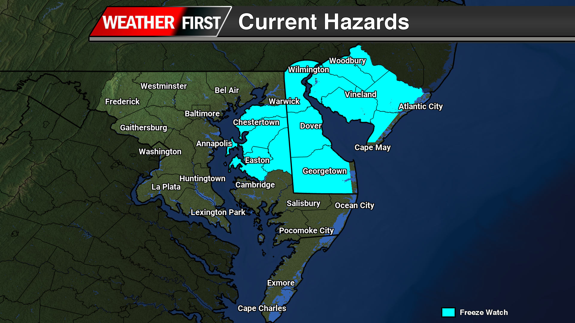
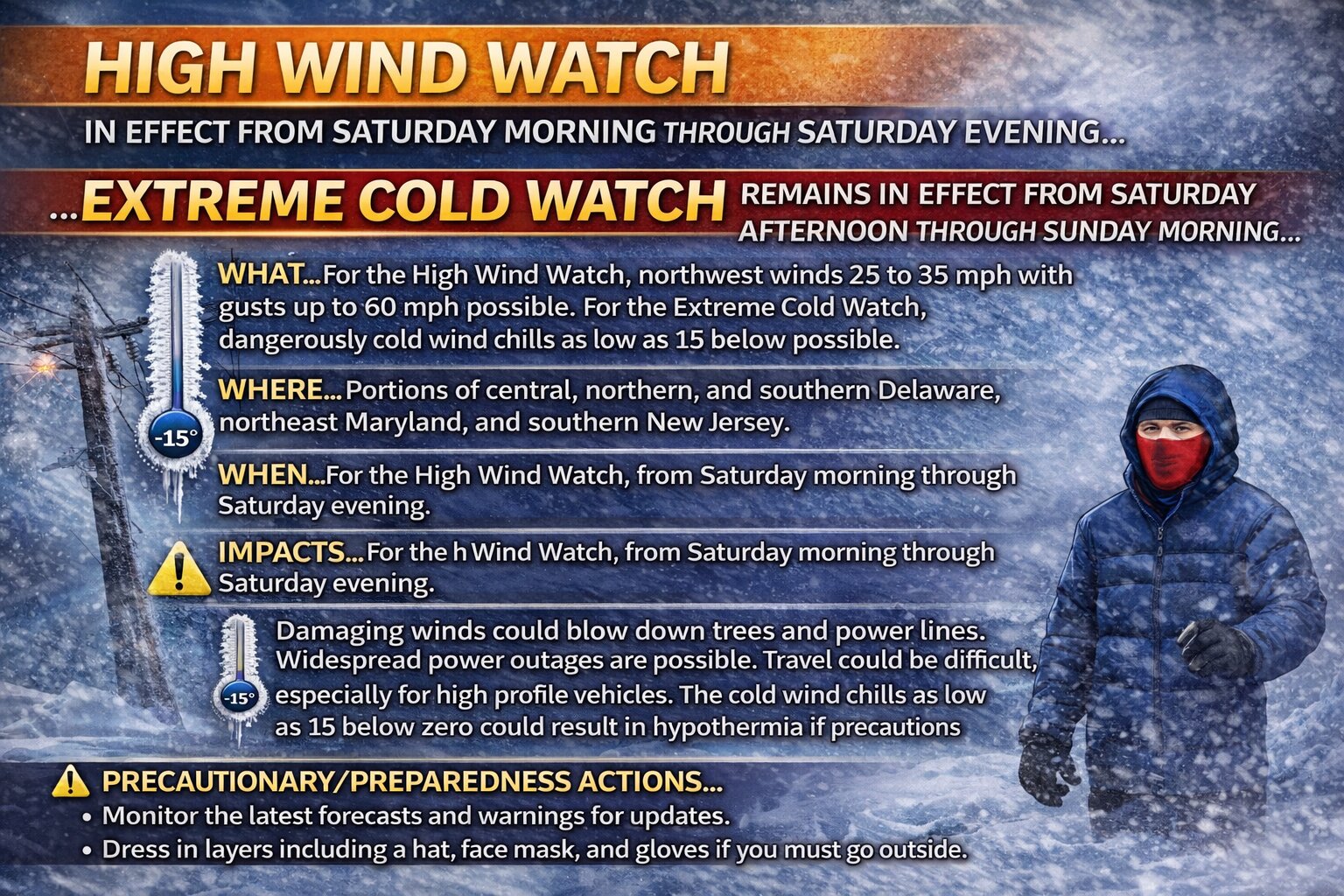
…FREEZE WATCH IN EFFECT FROM LATE TUESDAY NIGHT THROUGH WEDNESDAY MORNING…
* WHAT…Sub-freezing temperatures as low as 24 possible.
* WHERE…Portions of central, northern, and southern Delaware, northeast Maryland, central and southern New Jersey, and east central and southeast Pennsylvania.
* WHEN…From late Tuesday night through Wednesday morning.
* IMPACTS…Frost and freeze conditions could kill crops, other sensitive vegetation and possibly damage unprotected outdoor plumbing.
PRECAUTIONARY/PREPAREDNESS ACTIONS…
Take steps now to protect tender plants from the cold.
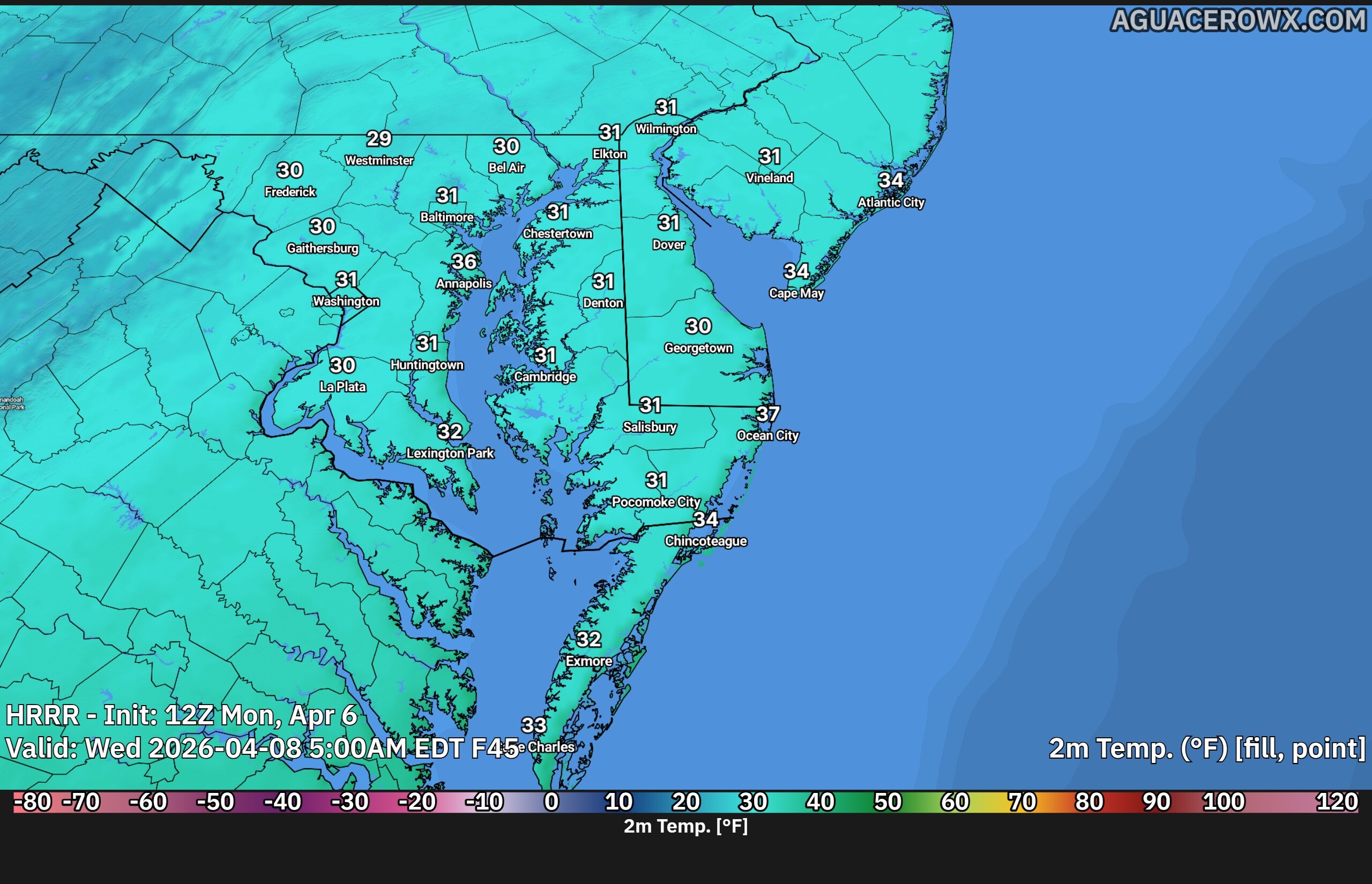
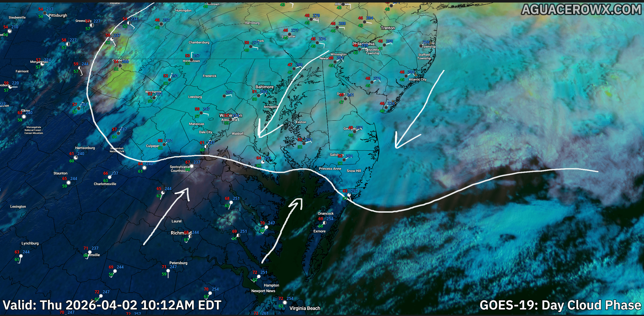
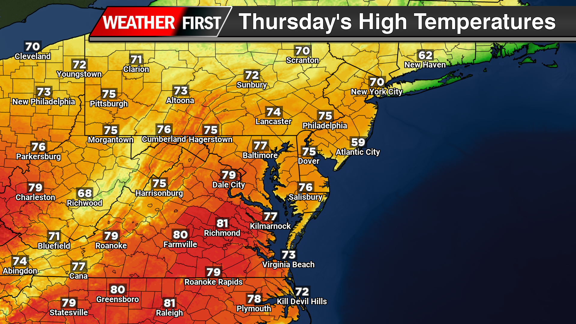
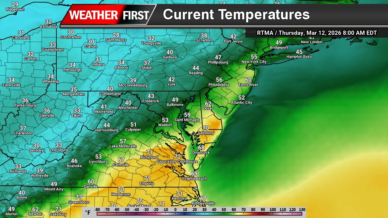
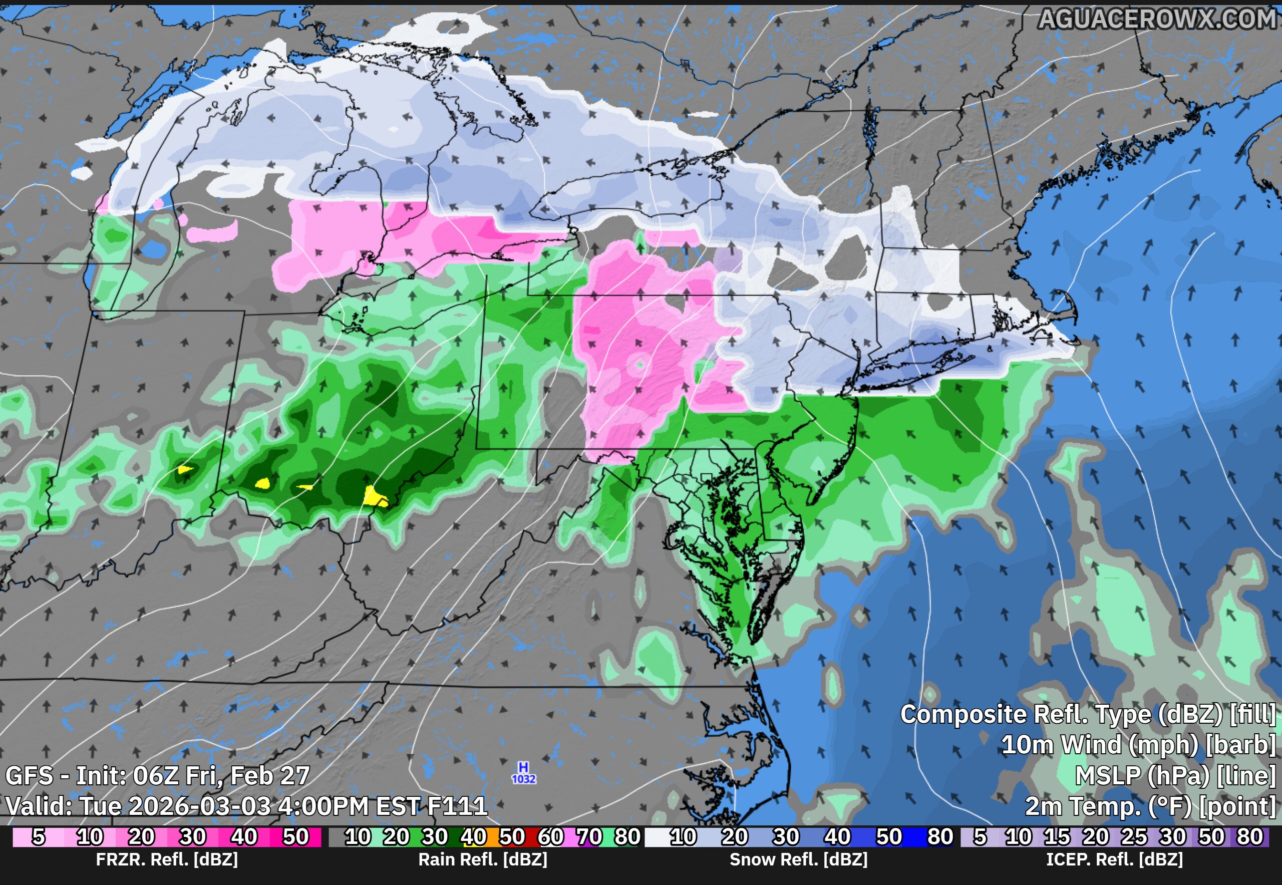
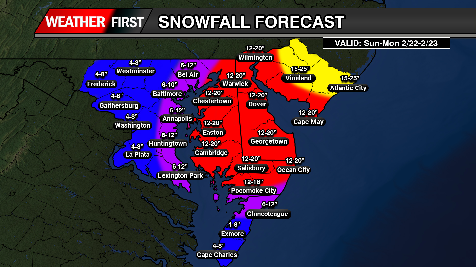
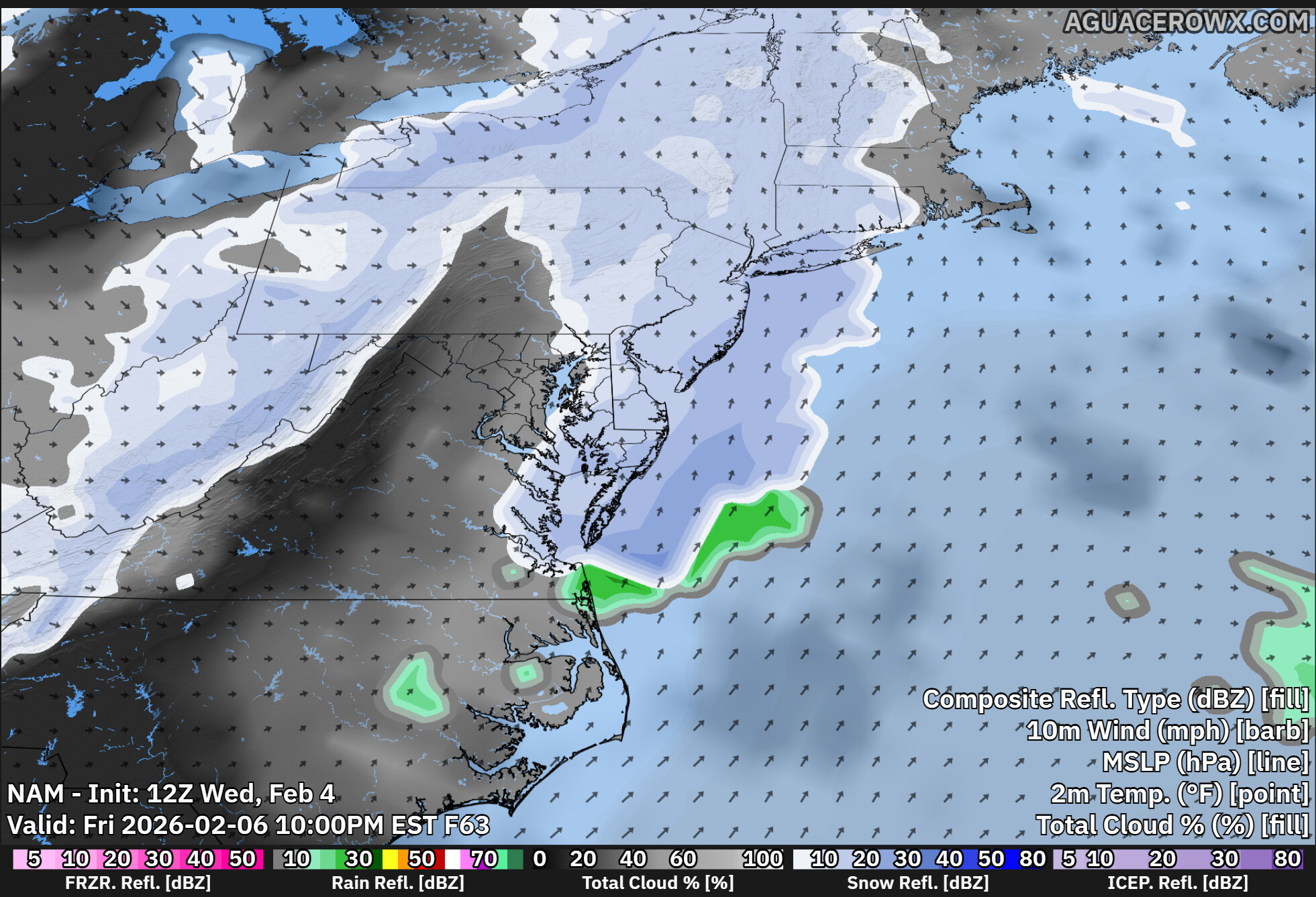
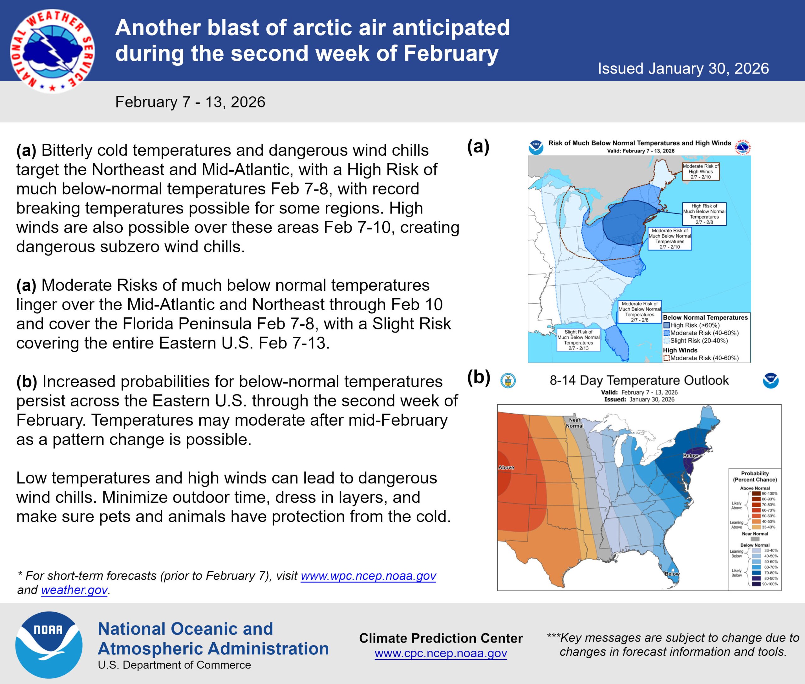
A brief but notable return to cold weather is expected across the Delmarva region midweek, with freezing temperatures likely Wednesday morning and additional frost concerns into Thursday.
A strong Canadian high pressure system will build into the Northeast following a cold front on Tuesday, allowing a surge of cold, dry air to settle over the region Tuesday night through Wednesday night. This setup will promote ideal radiational cooling conditions, with clear skies and light winds allowing temperatures to drop significantly by early Wednesday morning.
Most areas across Delmarva are expected to fall into the low to mid 30s closer to the coast, with upper 20s to low 30s further inland. There is a 50 to 60 percent chance that temperatures reach or drop below freezing, marking the coldest point of this stretch.
This timing is particularly important as the growing season is now active across much of Delmarva, with the exception of New Castle County, Delaware. That means sensitive vegetation and early agricultural interests could be vulnerable to damage from freezing temperatures. Despite the cold, the air mass will be quite dry, which should limit widespread frost formation Wednesday morning. However, a hard freeze alone can still have impacts regardless of frost presence.
We are monitoring the situation closely, and Freeze Warnings may be issued as confidence continues to increase in sub-freezing temperatures.
By Thursday morning, temperatures will remain chilly but trend slightly warmer as the center of high pressure shifts offshore. Lows are expected to hover closer to the freezing mark for many locations. With a modest increase in low-level moisture compared to Wednesday, patchy frost may develop, especially in more sheltered inland areas. This could lead to the need for Frost Advisories.
The cold snap will be short-lived. A warming trend begins Friday, with temperatures climbing well above freezing and continuing into the weekend, bringing more seasonable spring conditions back to the region.
Residents across Delmarva are encouraged to take precautions to protect sensitive plants ahead of Wednesday morning, as this will likely be the most impactful period for freezing temperatures.
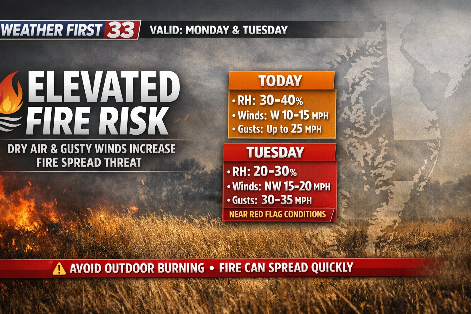
An elevated risk for fire spread is expected across the Delmarva Peninsula today, with conditions becoming more concerning on Tuesday as a much drier air mass moves into the region.
This afternoon, relative humidity values are forecast to fall into the 30 to 40 percent range. At the same time, westerly winds will increase to around 10 to 15 mph, with gusts reaching 20 to 25 mph. While these conditions support an elevated fire risk, they are not expected to reach critical thresholds today.
However, the situation changes heading into Tuesday.
A secondary cold front will move through the region early Tuesday, ushering in a significantly drier air mass. Dew points are expected to drop into the teens, which will allow relative humidity levels to fall even further, into the 20 to 30 percent range by the afternoon.
In addition, northwest winds will strengthen to around 15 to 20 mph, with gusts as high as 30 to 35 mph. This combination of low humidity and gusty winds will create conditions that are close to meeting Red Flag Warning criteria, which signals a high potential for rapid fire spread.
While the meteorological setup strongly supports critical fire weather conditions on Tuesday, recent rainfall may help limit the overall threat. Many areas across Delmarva picked up between a quarter and a half inch of rain on Sunday, with locally higher amounts near one inch across southern Delaware and parts of New Jersey.
That recent moisture could keep fine fuels, such as grasses and small vegetation, from drying out as quickly. Still, ongoing drought conditions across much of the region mean that fire risk remains elevated overall.
Officials are continuing to coordinate with fire weather partners to determine whether additional alerts, such as a Special Weather Statement or a Red Flag Warning, will be issued for Tuesday.
Residents are urged to avoid outdoor burning and use caution with any potential ignition sources, as fires could spread quickly under these conditions.
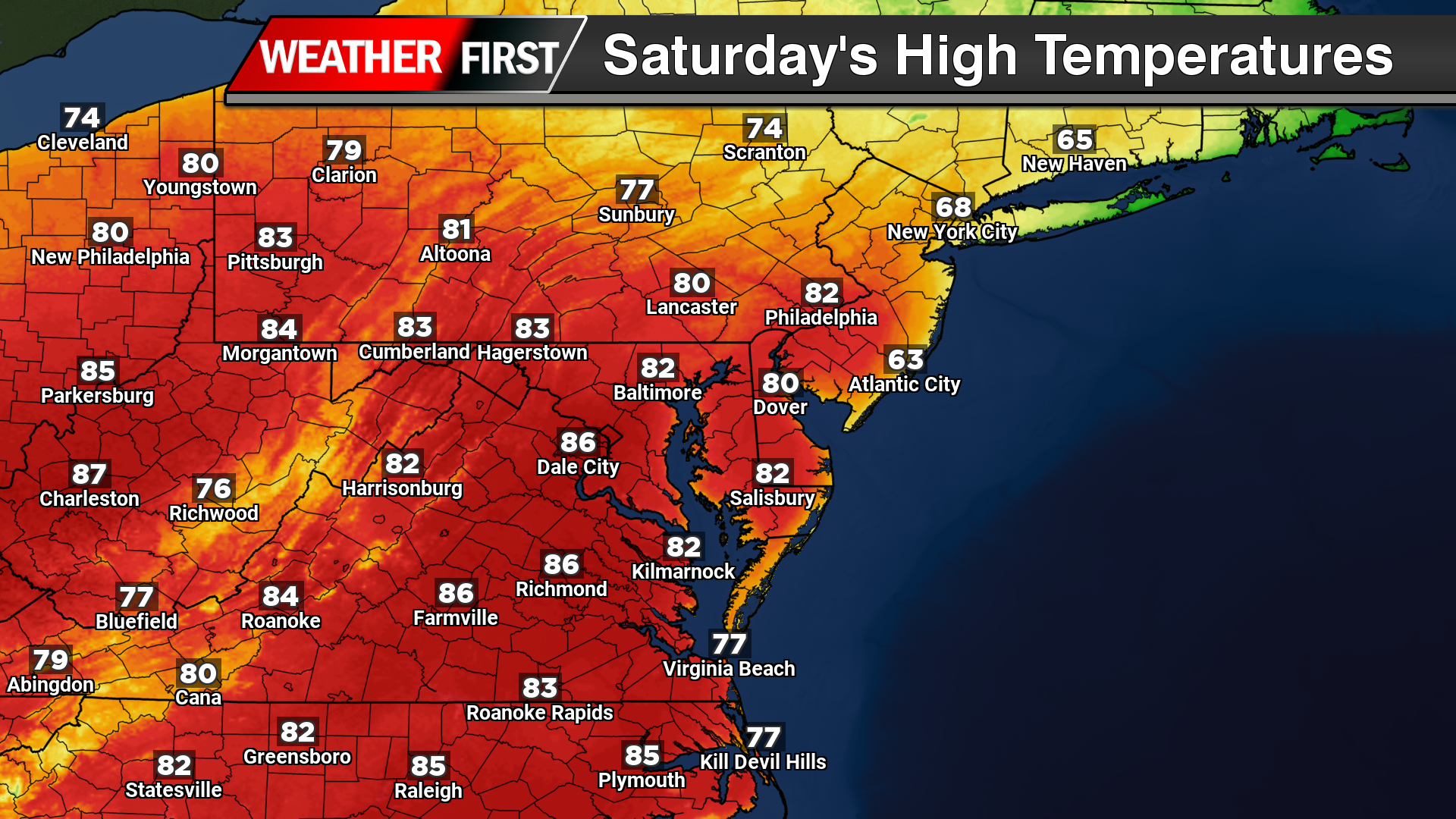
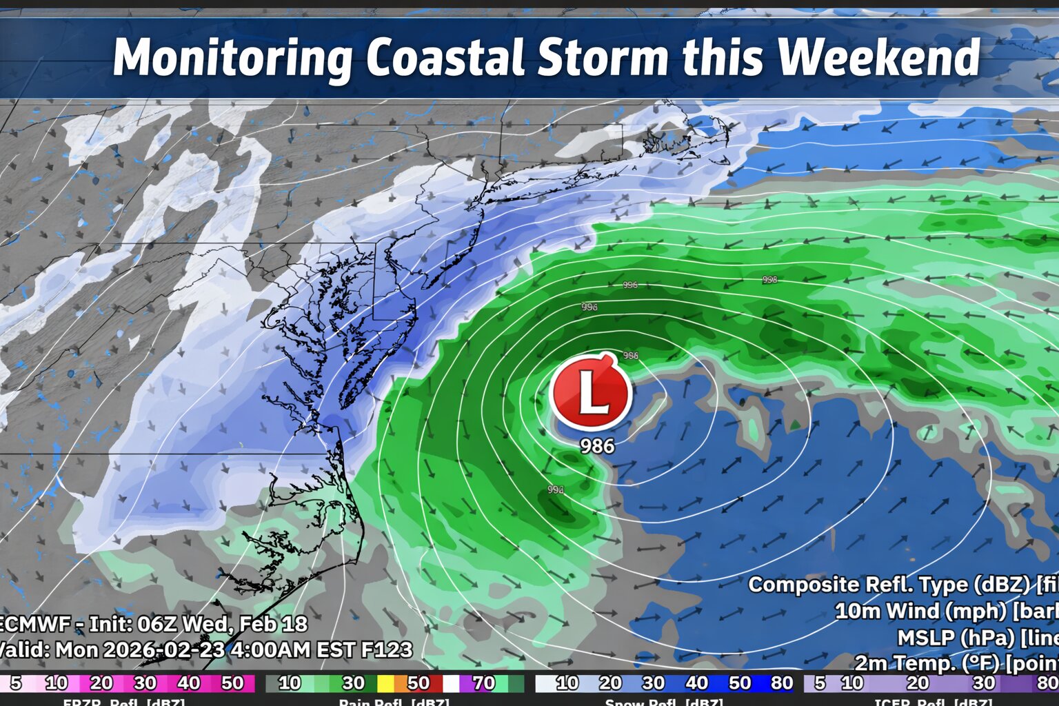
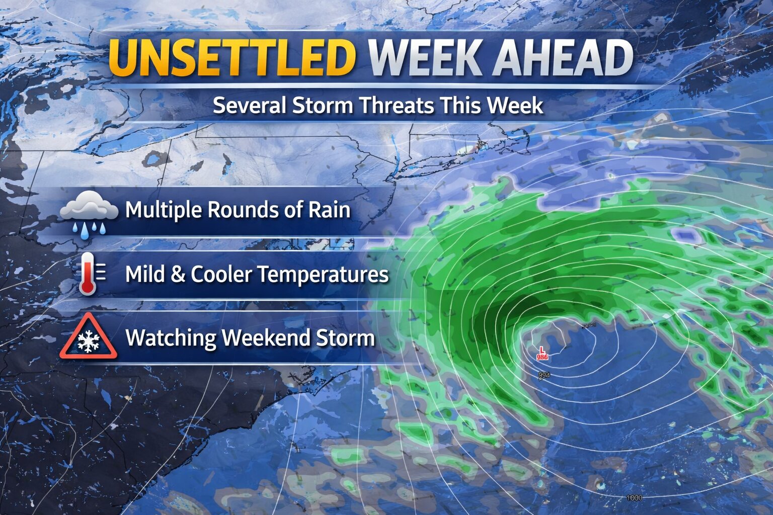
A changing weather pattern is expected across the Delmarva Peninsula this weekend, featuring a brief surge of warmth followed by rounds of showers and thunderstorms as a cold front sweeps through the region.
A developing low pressure system tracking through the Great Lakes will push a warm front northward across Delmarva on Saturday. This will place the region firmly in the warm sector, allowing temperatures to climb well above normal. Afternoon highs are expected to reach the upper 70s to low 80s under a mix of clouds and sunshine, providing a springlike feel across Delaware and the Eastern Shore of Maryland and Virginia.
Conditions will begin to shift late Saturday into Sunday as the trailing cold front approaches. This front is expected to bring multiple rounds of showers, and potentially a few thunderstorms, through the day on Sunday. While current global model guidance does not indicate a strong signal for widespread severe weather, this remains something to monitor. It is common for finer-scale details, including any severe potential, to become clearer as higher-resolution models come into range over the next couple of days.
One notable aspect of this system is the increase in atmospheric moisture. Precipitable water values are forecast to climb into the 1.3 to 1.5 inch range by Sunday, which is near the climatological maximum for early spring. This suggests the potential for locally heavier downpours, although widespread flooding is not anticipated at this time. Current projections indicate around a half inch of rainfall across much of the region, though localized higher amounts are possible depending on how showers and storms evolve.
Temperatures on Sunday will trend cooler compared to Saturday, with highs generally in the mid 60s to low 70s as clouds and precipitation become more widespread.
Behind the cold front, a noticeable pattern change will take place heading into early next week. Cooler, more seasonable air will settle into the region, bringing afternoon highs back into the 50s for much of Delmarva. This marks a return to near or slightly below average temperatures after the brief warmup over the weekend.
A noticeable shift in the weather pattern is underway across the Delmarva region today as a stalled frontal boundary lingers just to the south. This setup is bringing cooler temperatures and a more overcast sky compared to the recent stretch of warmth.
High temperatures today are expected to remain subdued, generally ranging from the mid 40s to mid 50s across Delaware and the Maryland Eastern Shore. Persistent cloud cover will dominate much of the day, and while widespread rainfall is not expected, a few isolated showers or areas of drizzle may develop at times.
As we head into tonight, the stalled boundary will begin lifting northward as a warm front. This transition will mark the beginning of a gradual warming trend. Temperatures may dip slightly this evening before stabilizing or even slowly rising overnight, especially across southern Delmarva. Overnight lows are now expected to range mainly in the low to mid 40s.
With increasing low-level moisture and lighter winds overnight, patchy fog may develop in some locations, potentially reducing visibility into early Friday morning. A few spotty showers could also accompany the northward-moving warm front.
By Friday morning, the warm front is expected to lift fully through the region, allowing for a significant rebound in temperatures. Afternoon highs will climb into the 70s, bringing a return to milder, more spring-like conditions across Delmarva.
Overall, today’s cooler and gray conditions will be short-lived, with a quick turnaround to warmer weather heading into the end of the week.
A developing severe weather setup will bring the potential for damaging storms across portions of the Mid-Atlantic later today, as an organized cluster of thunderstorms pushes east from the Midwest.
This morning, a complex of storms moving out of Missouri is expected to gradually track eastward, entering a more favorable environment for strengthening as it approaches the Ohio Valley and eventually the Mid-Atlantic. Ahead of this system, warmer and more unstable air will continue to build across the region through the afternoon, helping to fuel additional storm development.
This setup is being driven by increasing instability south of a frontal boundary combined with moderate westerly flow aloft. While wind shear is not particularly strong, it is sufficient to support organized storm structures, especially in the form of bowing line segments. These types of storm features are efficient at producing strong to damaging wind gusts, which will be the primary severe weather hazard.
The highest concentration of storms, along with the greatest risk for severe weather, is expected to extend from the middle Ohio Valley eastward into the Mid-Atlantic by the late afternoon and evening hours. For areas across Delmarva and surrounding regions, storms may arrive during the late day or early evening timeframe.
While widespread severe weather is not expected, any stronger storms that develop could produce localized damaging winds, brief heavy downpours, and possibly small hail. The progressive nature of the system should limit the duration of impacts at any one location, but conditions could change quickly as storms move through.
Residents are encouraged to stay weather-aware throughout the day, especially during the afternoon and evening when storm intensity is expected to peak. Having multiple ways to receive warnings will be important as this system evolves.
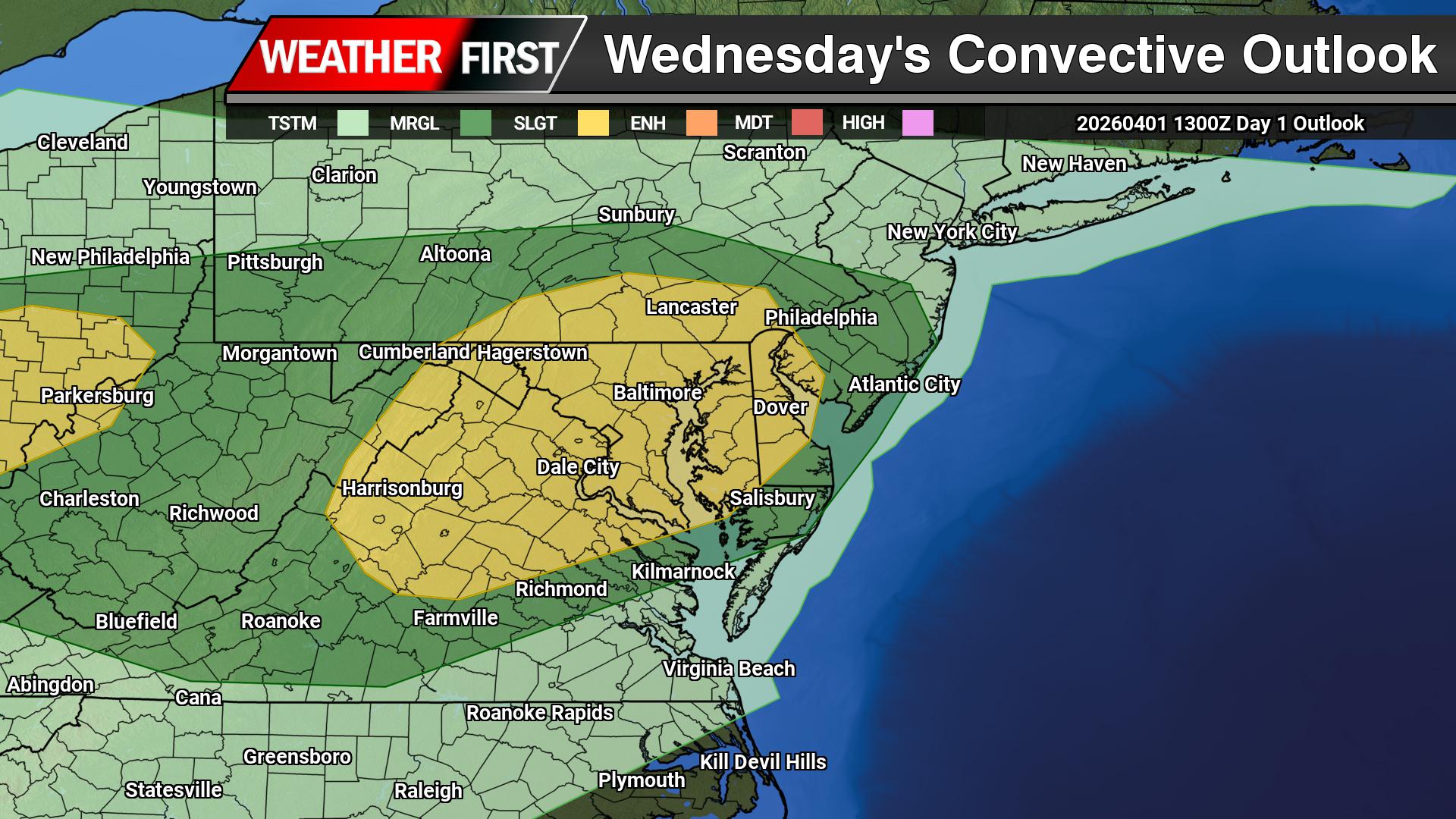
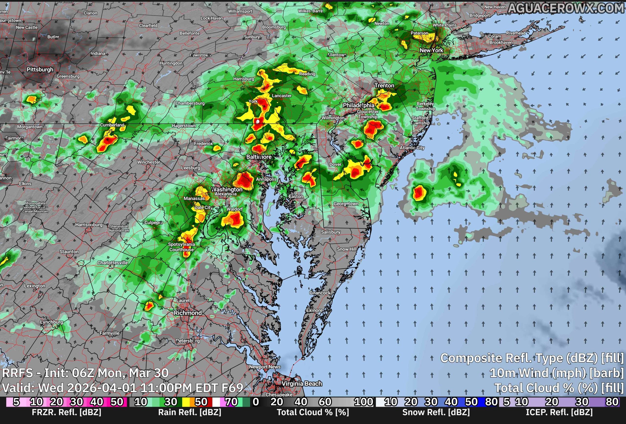
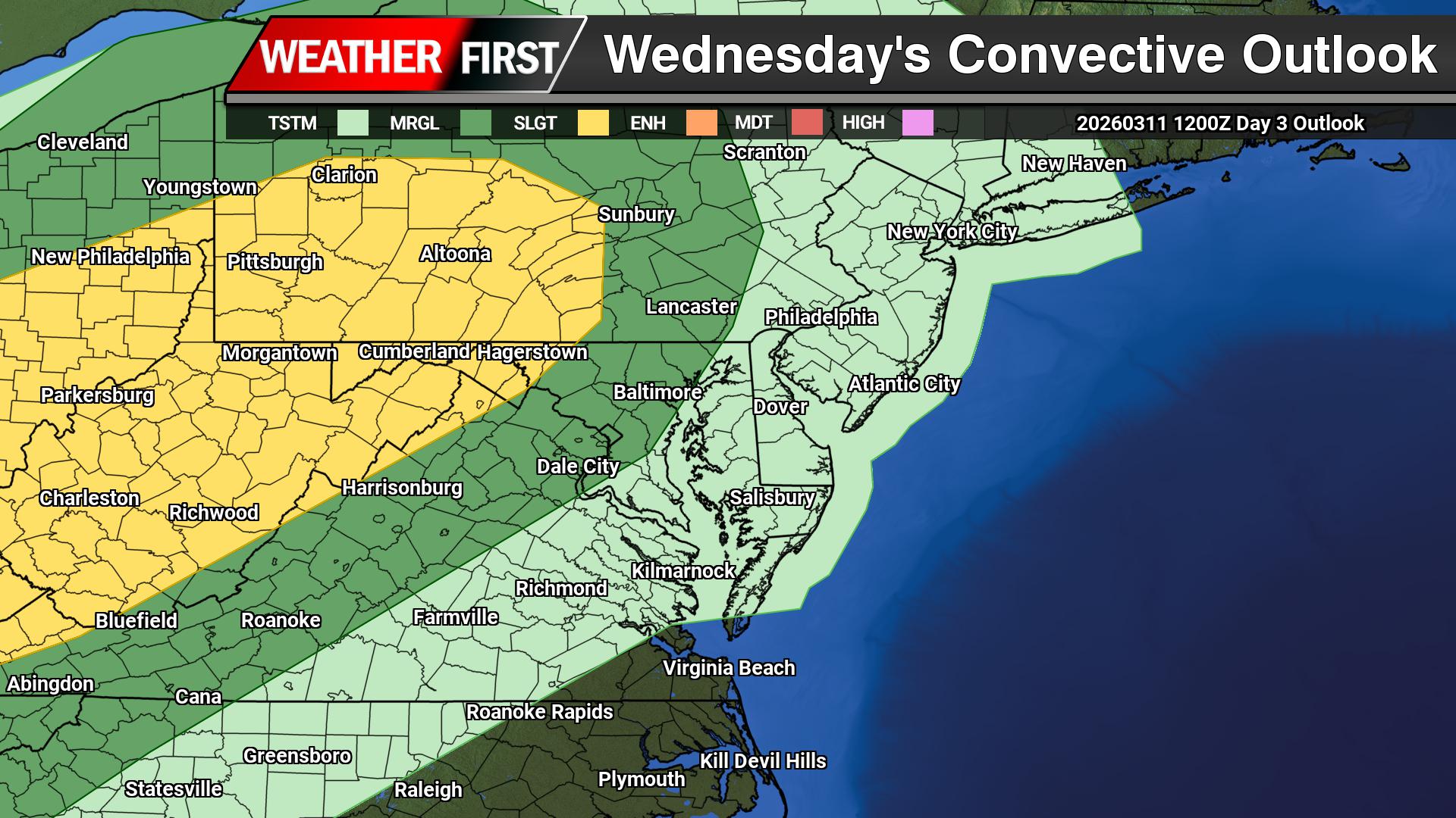
A stalled boundary draped across parts of the Mid-Atlantic will act as a focus for developing showers and thunderstorms Wednesday, especially during the afternoon and early evening hours.
As temperatures warm through the day, rising heat and moisture in the atmosphere will help fuel storm development. This process, known as daytime heating, will allow scattered storms to form along the boundary, though coverage is expected to remain somewhat limited, meaning not everyone will see rain.
While the overall setup is not highly favorable for widespread severe weather, a few storms could become stronger and more organized. These storms may be capable of producing large hail and gusty to damaging winds, particularly during the peak heating of the afternoon.
There is also the potential for some storms to group together into small clusters, which can increase the risk of stronger wind gusts as they move through. However, the threat remains isolated, and many areas will avoid severe conditions altogether.
Residents across the Mid-Atlantic should stay weather-aware Wednesday, especially if you have outdoor plans. Keep an eye on the sky and be prepared to move indoors quickly if a storm approaches.
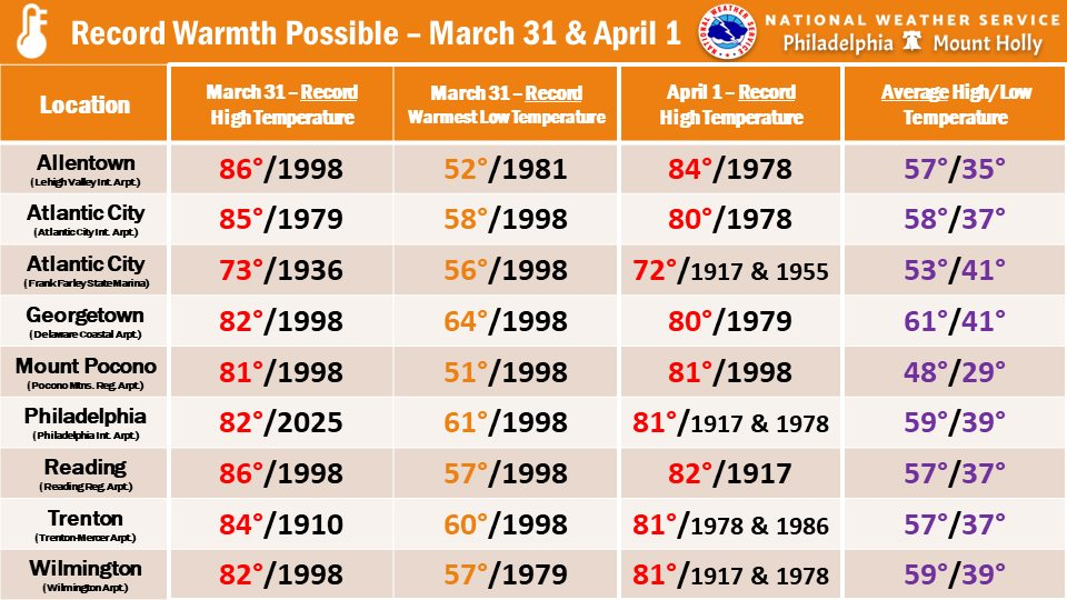
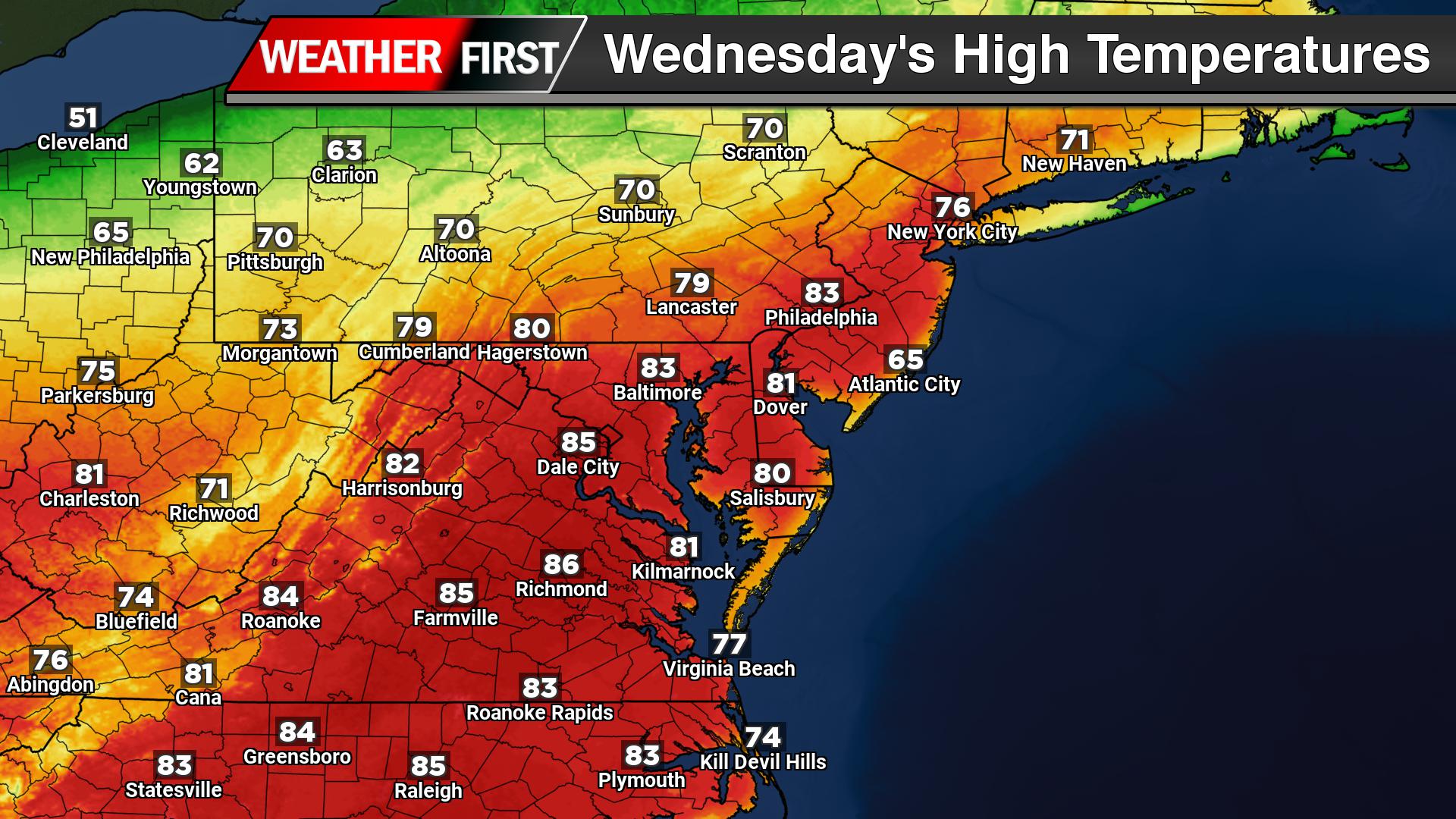
Unseasonably warm air has surged into the Delmarva region, bringing temperatures close to record levels today and continuing into Wednesday. A strengthening southwest flow, fueled by high pressure positioned offshore, is allowing much warmer air to overspread the region, pushing afternoon highs to near or even above 80 degrees in many inland areas. Coastal locations remain slightly cooler, but still well above seasonal averages for late March.
This level of warmth puts several locations within striking distance of daily record highs. After a few early clouds and spotty showers this morning, partial sunshine will help temperatures climb quickly through the afternoon. While a few isolated showers or thunderstorms may attempt to move in from the west later today, most activity is expected to weaken before reaching much of Delmarva, keeping the overall severe weather threat low.
The mild pattern continues overnight, with temperatures holding in the 60s across much of the region, more typical of late spring than early April. This sets the stage for another very warm day on Wednesday, where some parts of southern Delmarva could end up even warmer than today. However, a cold front approaching from the northwest will begin to complicate the forecast, especially farther north where slightly cooler air may start to edge in.
By Wednesday afternoon and evening, that cold front will move into the region, bringing an increasing chance for showers and a few thunderstorms. While instability will be somewhat limited, a marginal risk for isolated strong storms exists, mainly across western areas. Any storms that do develop could produce gusty winds, but widespread severe weather is not expected.
This brief surge of near-record warmth will come to an end behind the front, with cooler and more seasonable conditions expected to return heading into the latter part of the week.
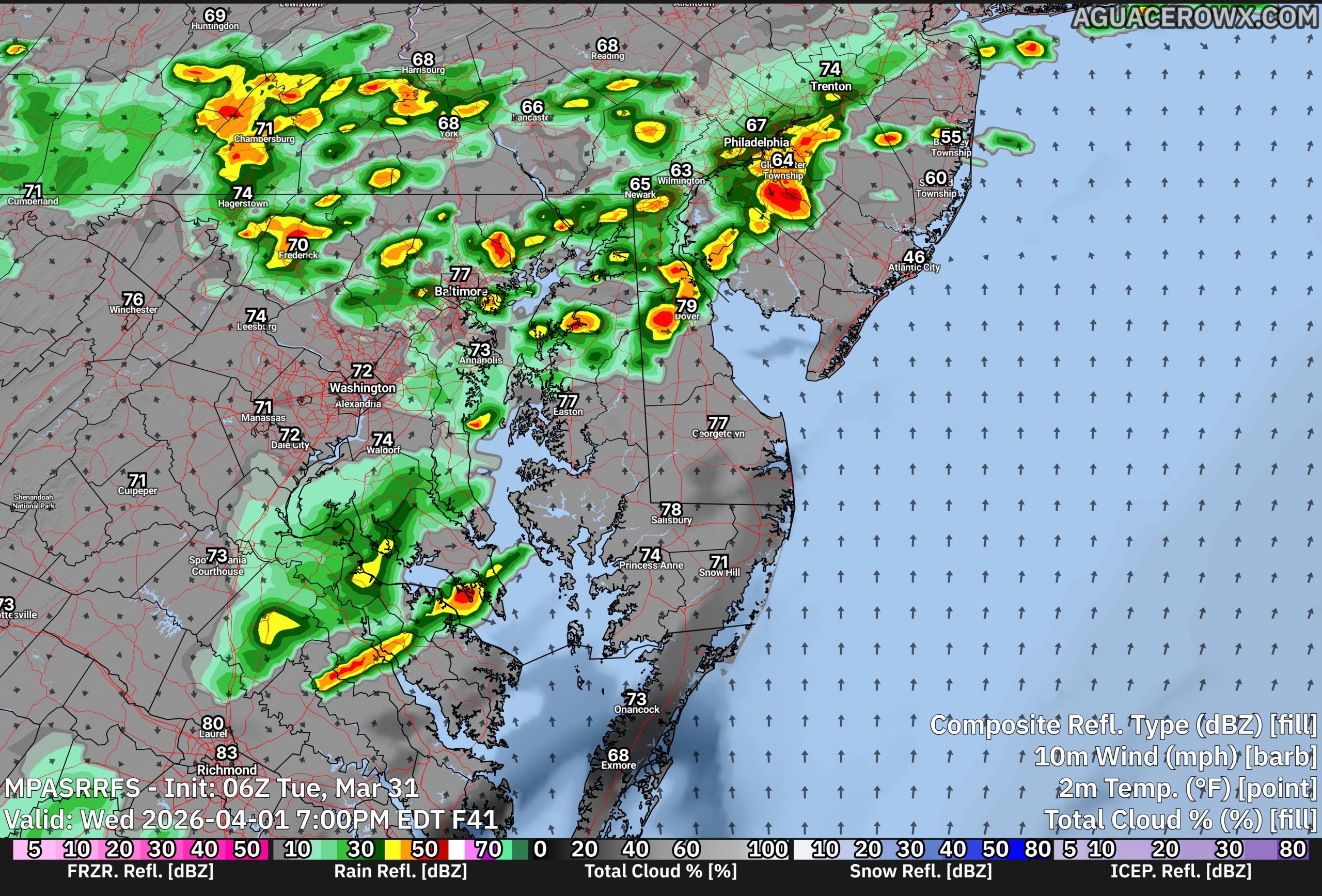
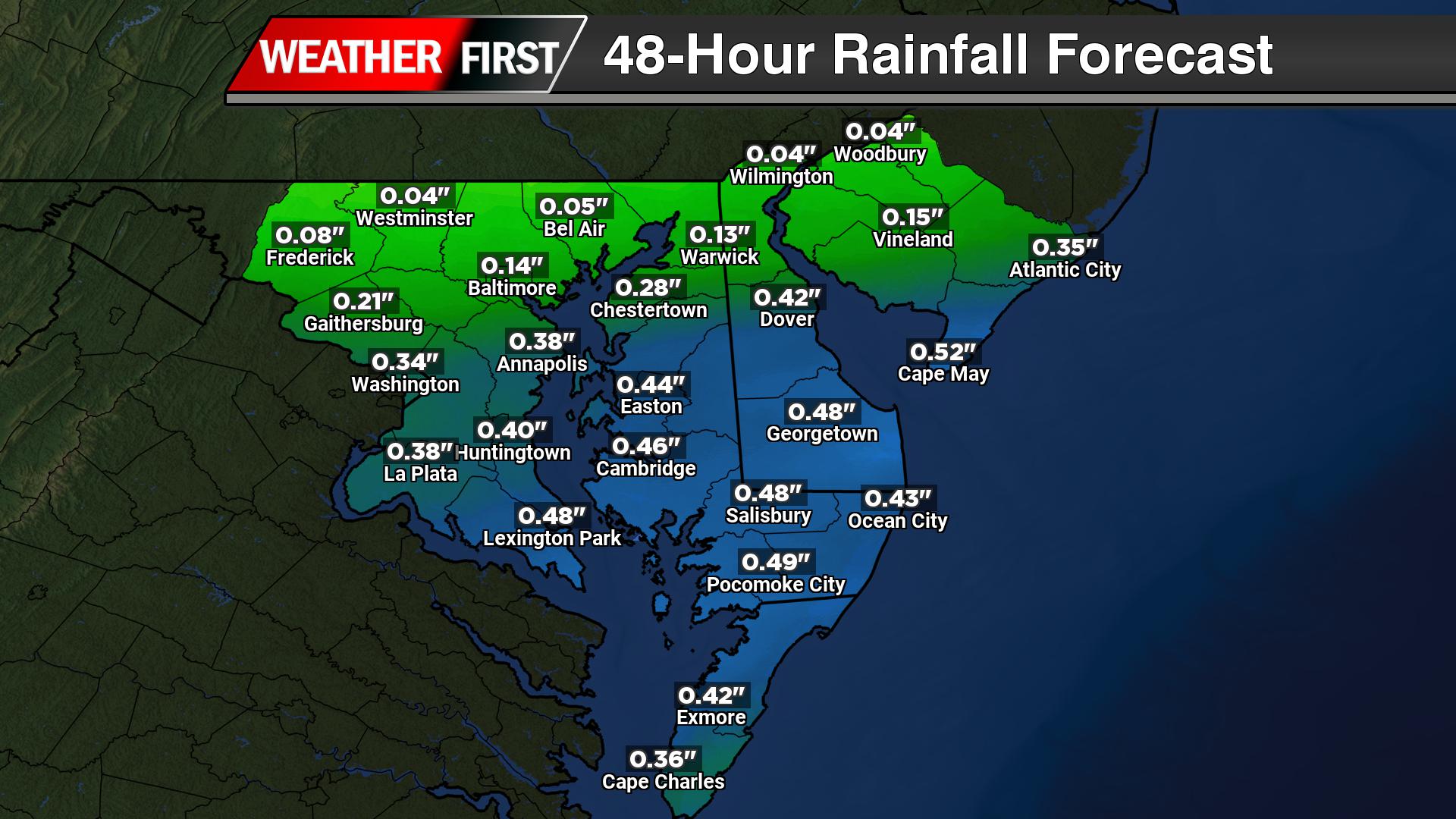
A summer-like surge of warmth across the Delmarva Peninsula will come to an end Wednesday night as a cold front pushes through the region, bringing a round of showers and a few thunderstorms during the afternoon and evening hours.
Ahead of the front, Wednesday is shaping up to be another unseasonably warm and humid day. Temperatures are expected to climb into the upper 70s to near 80 degrees across much of Delmarva, with some locations potentially challenging daily record highs. The combination of warmth and increasing humidity will create a more unstable atmosphere by late in the day.
That setup will allow for the development of scattered showers and thunderstorms, mainly during the mid to late afternoon and into the evening hours. While a few storms could become locally strong, the overall severe weather threat remains low at this time. Forecast soundings indicate some instability will be present, but wind shear appears limited, which should prevent widespread organized severe storms. Current guidance from the Storm Prediction Center does not highlight the region for severe weather in the Day 3 outlook, reinforcing the limited threat.
Rainfall amounts are expected to be relatively light, generally ranging from a tenth to a half inch, with the higher totals likely staying north and west of the I-95 corridor. No flooding concerns are anticipated given the modest rainfall rates and progressive nature of the system.
Showers may linger into the overnight hours Wednesday before the cold front clears the region, setting the stage for a cooler and less humid air mass heading into the end of the week.
A noticeable warming trend is underway across the Delmarva Peninsula as a warm front begins lifting north through the region, bringing a mix of increasing clouds, spotty showers, and a significant jump in temperatures through mid-week.
High pressure has shifted offshore to the southeast, allowing a milder and more humid air mass to move in. As the warm front pushes northward today into early Tuesday, skies will turn mostly cloudy with the chance for scattered light showers developing later today and lingering into Tuesday. While a brief rumble of thunder cannot be ruled out overnight, the overall setup remains weak, with minimal impacts expected. Rainfall totals will be light, generally a few tenths of an inch or less, and no severe weather is anticipated.
The more notable story will be the warming temperatures. Highs today will climb into the 60s for most inland locations, with a few spots nearing 70 degrees, though cooler conditions will persist along the immediate coast due to onshore flow. Overnight lows will remain mild, settling into the 50s.
By Tuesday, much warmer air takes hold, with highs surging into the mid to upper 70s across much of Delmarva. The warming trend peaks on Wednesday, when temperatures are expected to reach well into the 80s for many areas. Overnight lows will also turn unseasonably warm, staying in the 60s, creating a noticeably more humid feel.
These temperatures could approach or even challenge record highs for late March, marking a sharp shift from recent cooler conditions. While clouds and a few showers may pass through at times, the dominant theme through mid-week will be spring warmth building across the region.
...NWS Damage Survey for 03/11/26 Prospect Hills MD Tornado...

.Prospect Hills, MD Tornado...

Rating:                 EF-0
Estimated Peak Wind:    80 mph
Path Length /statute/:  0.3 miles
Path Width /maximum/:   75 yards
Fatalities:             0
Injuries:               0

Start Date:             Mar 11 2026
Start Time:             7:14 PM EDT
Start Location:         Prospect Hills / Carroll County / MD
Start Lat/Lon:          39.357 / -76.893

End Date:               Mar 11 2026
End Time:               7:15 PM EDT
End Location:           Prospect Hills / Carroll County / MD
End Lat/Lon:            39.360 / -76.890

Survey Summary:

A supercell thunderstorm moved through northern Montgomery,
northwestern Howard, and southeast Carroll Counties in Maryland
during the evening hours of Wednesday March 11, 2026. The bow echo
and associated downbursts/thunderstorm wind gusts caused sporadic
tree damage from 60 to 80 mph gusts, and created both a brief EF1
tornado near Cooksville in northwestern Howard County for which
there is a previous report, and this EF0 tornado in Prospect Hills
MD, in southeastern Carroll County in the Patapsco Valley State
Park.

As the storm crossed into southeastern Carroll County, it
produced a brief tornado in Patapsco Valley State Park, with an
EF0 touching down at 7:14 pm. In the park, just east of
Marriottsville Rd, there were numerous trees uprooted and snapped.
The most intense area of tree damage was right along the entrance
drive in the McKeldin Area. Peak winds in this area were
estimated to be 80 mph. Several trees were snapped down in
multiple directions in a path up to 75 yards wide. Shortly after,
the tornado lifted at 7:15 pm and no further tornadic damage was
noted. However, sporadic wind damage in the direction of storm
motion continued to occur with the winds from the severe
thunderstorm.

Special thanks to Montgomery and Carroll County Offices of
Emergency Management for their assistance and damage assessments.

&&

EF Scale: The Enhanced Fujita Scale classifies tornadoes into the
following categories:

EF0.........65 to 85 mph
EF1.........86 to 110 mph
EF2.........111 to 135 mph
EF3.........136 to 165 mph
EF4.........166 to 200 mph
EF5.........>200 mph
A shift in the weather pattern behind today’s cold front could bring an increased risk for fire spread across the Delmarva Peninsula heading into Saturday.
Canadian high pressure building into the region will usher in a much drier and cooler airmass. While skies will turn partly to mostly sunny, the combination of low humidity and gusty winds is raising some concern. Relative humidity values are expected to drop into the 25 to 30 percent range, while northwest winds increase to around 10 to 15 mph with gusts between 25 and 30 mph.
The Frostburg Index, developed by the National Weather Service office in Frostburg, Maryland, is a fire weather tool used in the Mid-Atlantic to estimate how easily fires can start and spread. It combines key factors like relative humidity, wind speed, and temperature to gauge fire risk, with higher values indicating a greater potential for rapid fire growth. The index is especially useful during dry, breezy periods in spring and fall when vegetation is more prone to ignition.
This setup can enhance the potential for fires to spread more quickly, especially in areas with dry vegetation. Early spring is a particularly vulnerable time across Delmarva, as dormant grasses and brush can ignite easily under these conditions.
One key factor that may help limit the overall threat is rainfall from today’s system. Recent moisture will help keep fuels from becoming critically dry, reducing the likelihood of widespread fire issues. However, localized concerns could still develop, particularly in areas that see lighter rainfall totals.
Residents are encouraged to use caution with any outdoor burning on Saturday, as conditions may allow fires to spread more rapidly than expected.
A cold front sweeping through the Delmarva Peninsula early this morning is bringing scattered showers, gusty winds, and a noticeable shift toward colder conditions as the day progresses.
Rain associated with the front will continue through much of the morning, particularly across Delaware and the Maryland Eastern Shore. While the system is not especially strong, most locations can expect rainfall totals ranging from around a quarter inch up to a half inch. The rain will gradually taper off from west to east, with many areas turning dry by early afternoon. However, a few lingering showers may persist into the mid to late afternoon, especially across southern Delmarva.
Behind the front, breezy conditions will develop through the morning hours, with wind gusts between 20 and 30 mph. Winds will begin to ease later in the afternoon as drier air moves in.
The most noticeable change will be temperatures. Mild conditions early this morning, with readings in the 60s and even low 70s, will not last. Temperatures will steadily fall throughout the day, dropping into the upper 40s and low 50s by the afternoon. That cooling trend will continue into tonight, with lows falling into the mid to upper 20s across inland areas and near the low 30s closer to the coast.
This marks a return to below-normal temperatures across Delmarva heading into the weekend, following the brief stretch of early spring warmth.
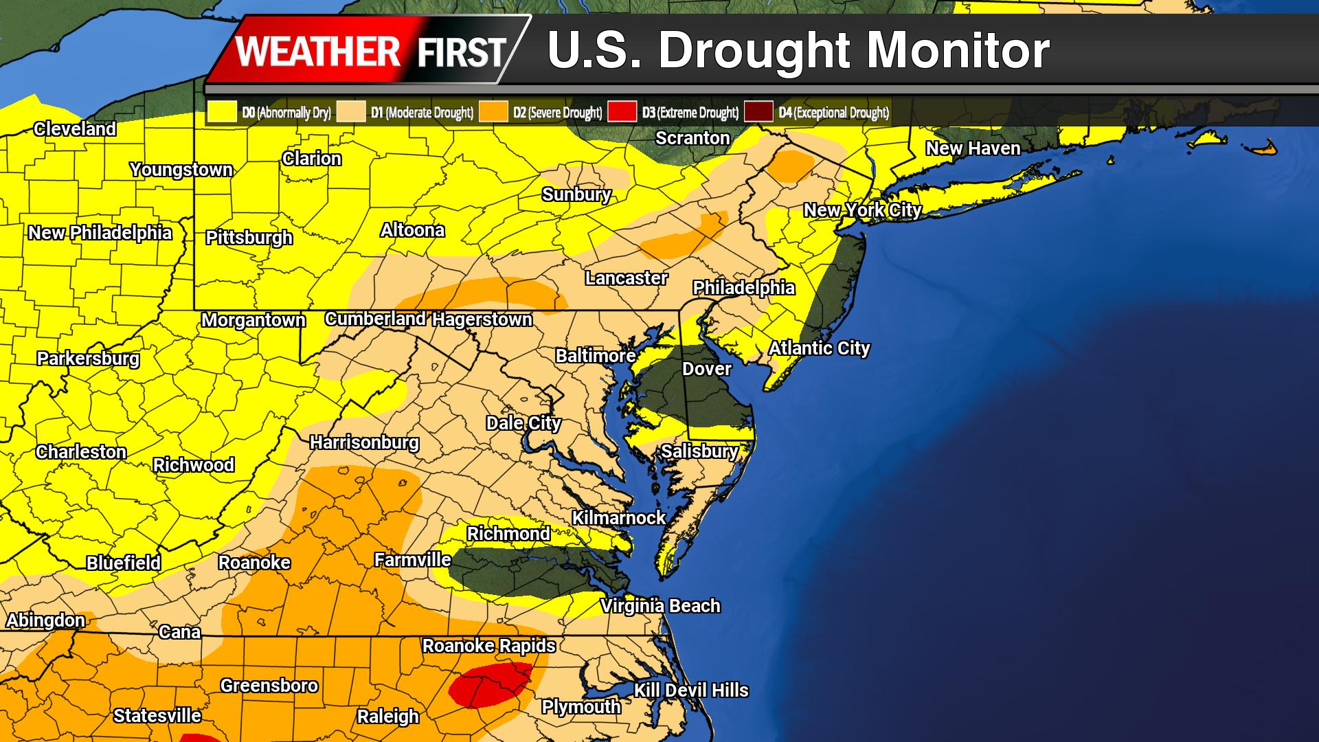
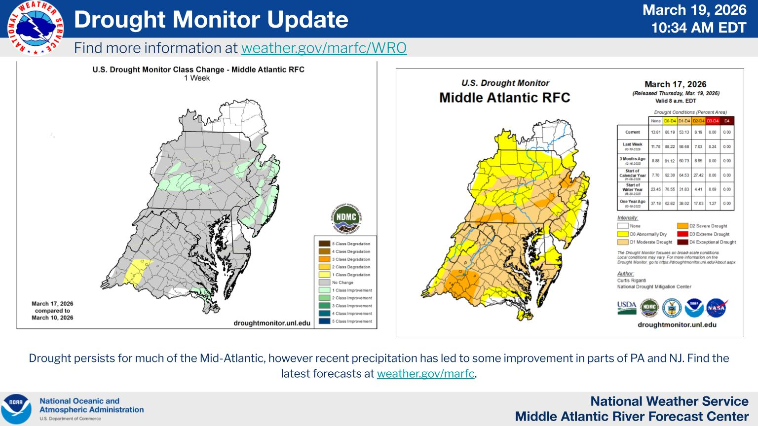
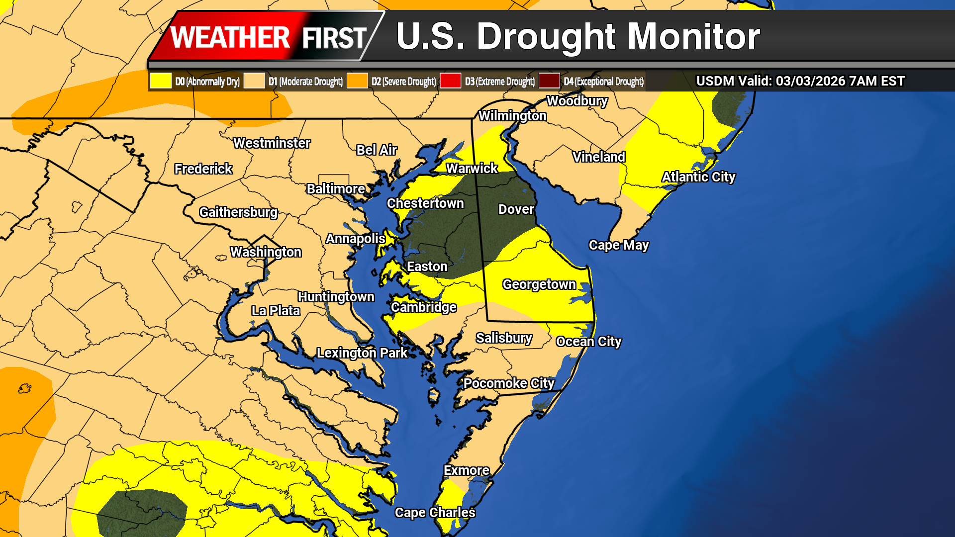
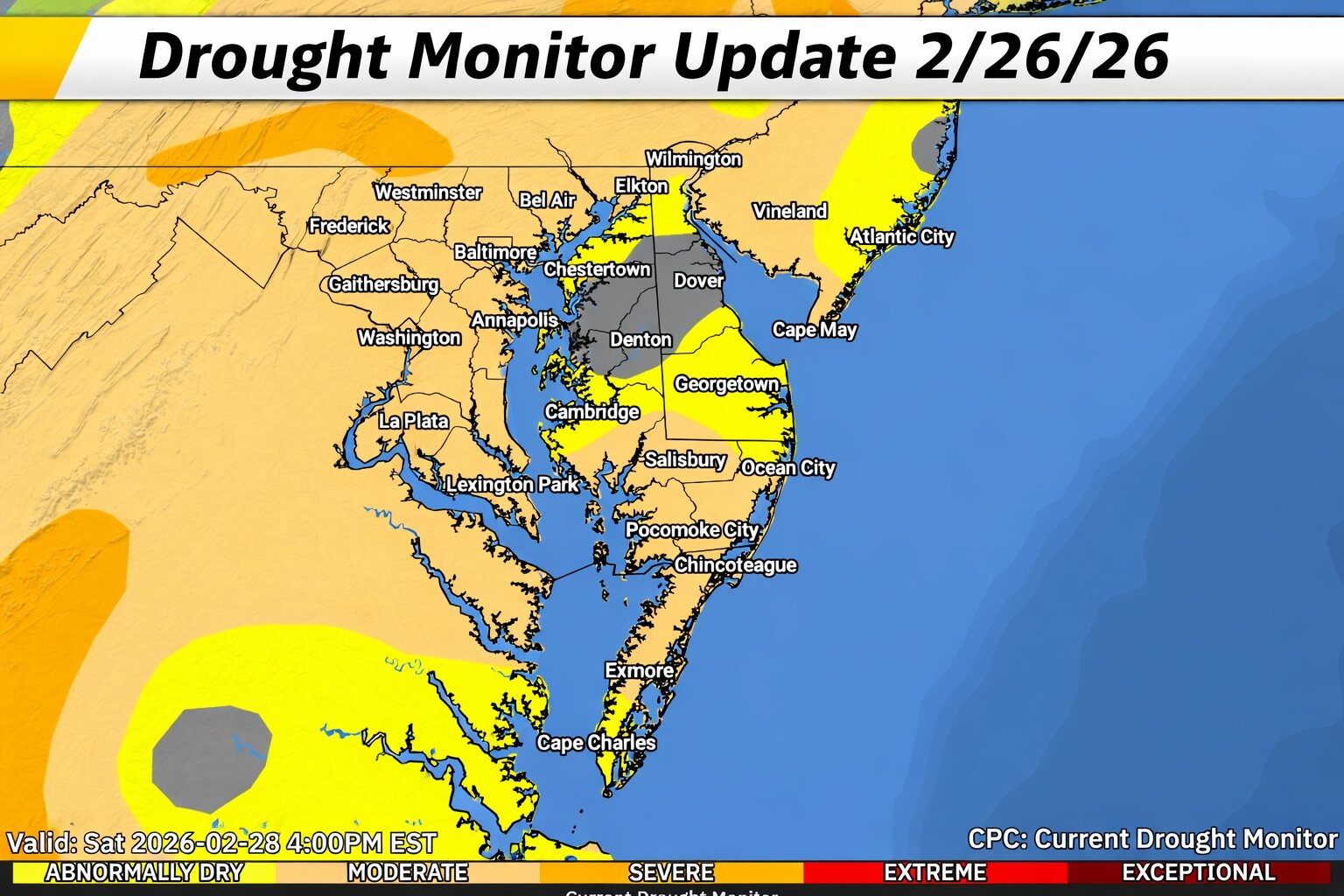
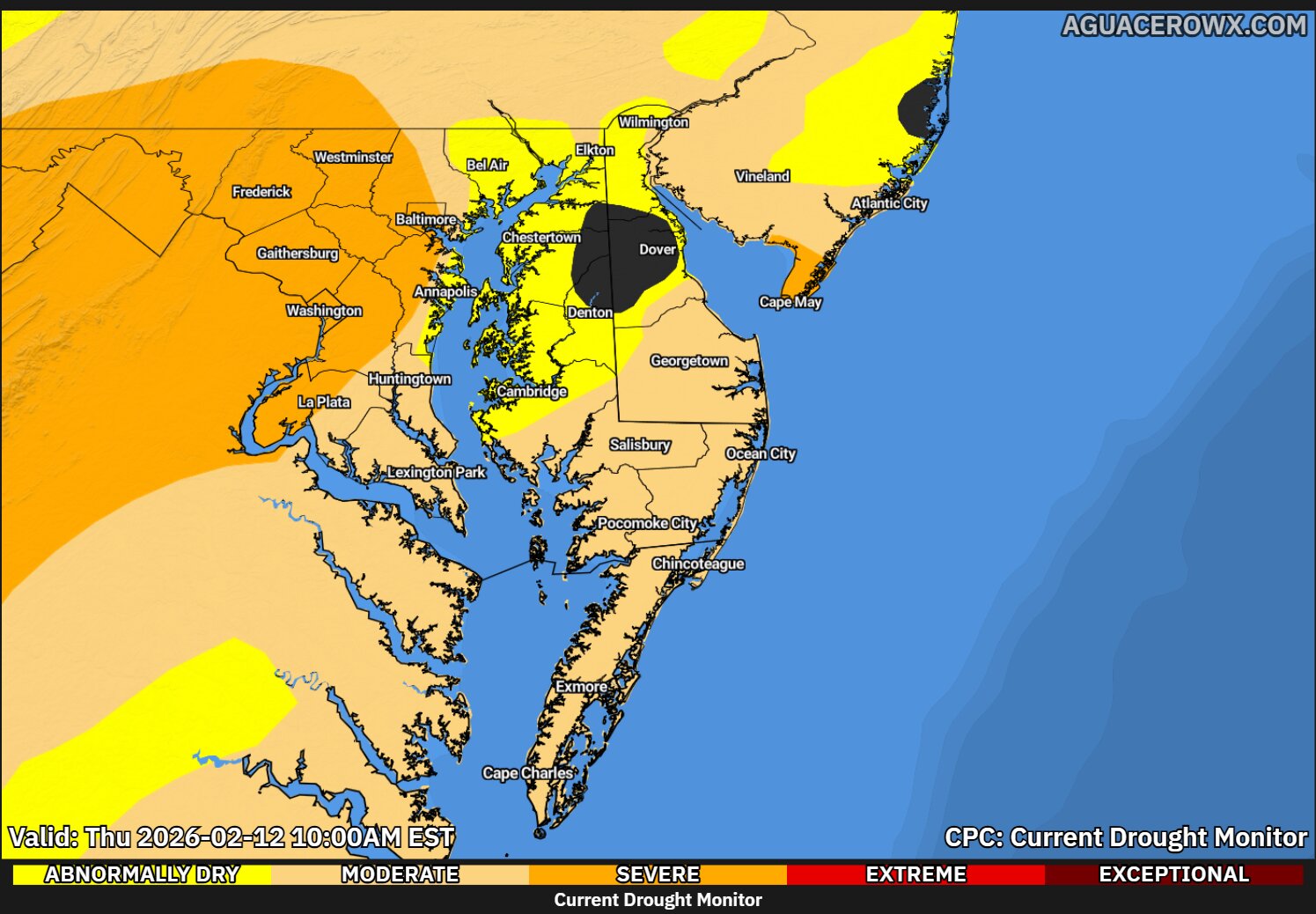
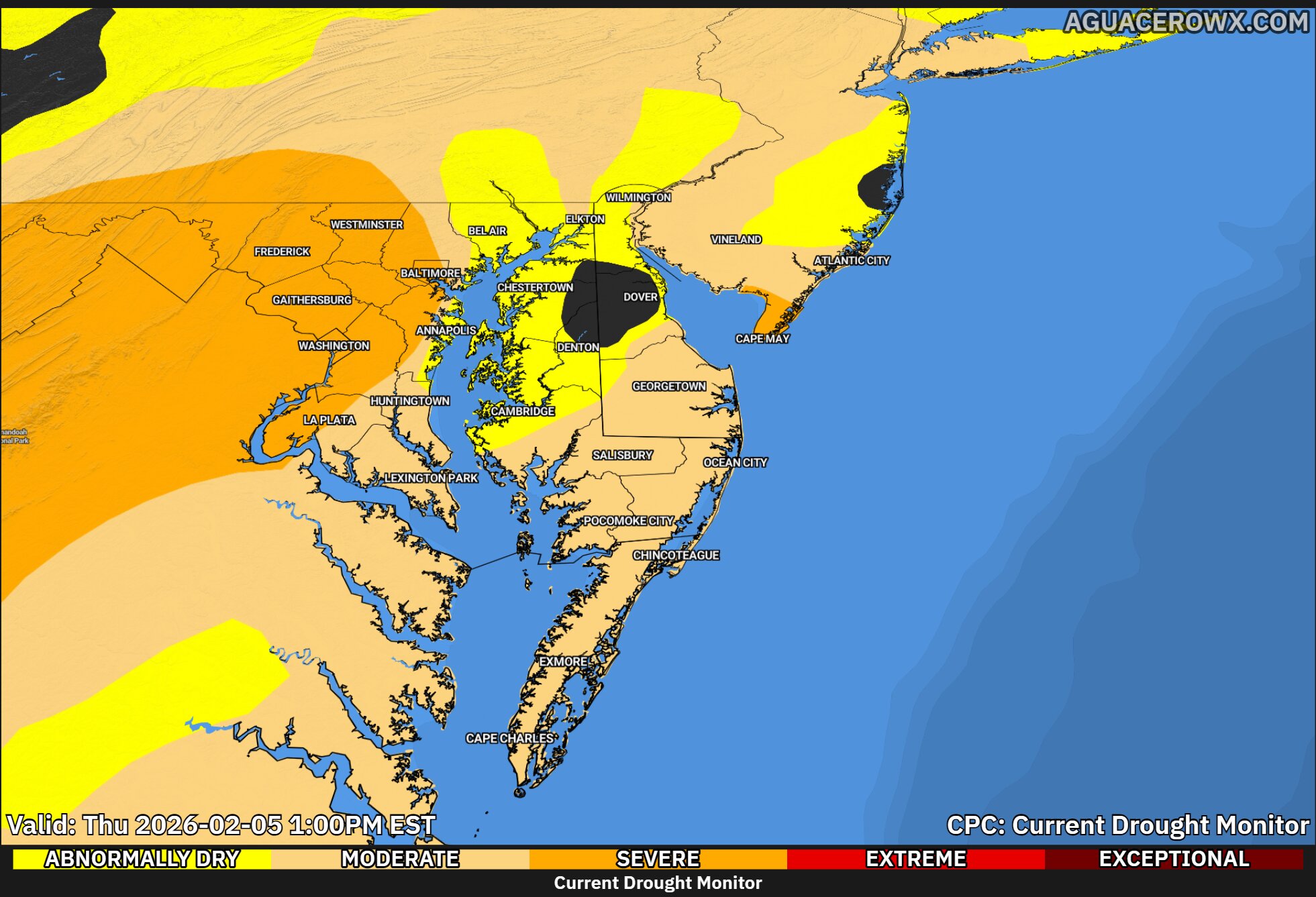
Drought conditions continue to hold firm across much of the Mid-Atlantic, with the latest U.S. Drought Monitor outlook showing little overall improvement and ongoing long-term dryness across the region.
A prolonged stretch of below-normal precipitation dating back through the winter months has led to widespread moisture deficits, particularly across portions of Maryland, Delaware, Pennsylvania, and New Jersey. In many areas, 12 to 24 month rainfall deficits exceed several inches, highlighting the long-term nature of this drought.
Across the Mid-Atlantic, streamflows remain well below normal, in some cases falling into the lowest 10th percentile, signaling continued stress on water resources and ecosystems. The drought is being driven by a combination of persistent dry conditions, limited storm systems, and periods of above-normal temperatures, which have accelerated soil moisture loss.
The drought classification system used by the Drought Monitor ranges from Abnormally Dry (D0) to Exceptional Drought (D4), with parts of the broader region experiencing moderate to severe drought conditions (D1–D2), and locally higher in some areas nearby.
Recent rainfall events across parts of the eastern U.S. have brought minor improvements in some nearby regions, but for the Mid-Atlantic, the overall trend remains largely stagnant, with drought coverage and intensity holding steady week-to-week.
Looking ahead, meaningful drought relief will depend on more consistent and widespread precipitation over the coming weeks, especially as the region heads deeper into the spring growing season where water demand increases.
A brief surge of spring warmth is expected across the Delmarva Peninsula and Maryland’s Eastern Shore today, but a cold front will bring a return to cooler and unsettled conditions heading into Friday.
High pressure positioned offshore near the Canadian Maritimes is continuing to drift out to sea, allowing a strengthening southwest flow to develop across the region. This setup is driving warm air advection, pushing temperatures well above normal for late March. Afternoon highs are expected to climb into the low to mid 70s, running roughly 15 to 20 degrees above average. Skies will remain partly to mostly sunny through much of the day, though increasing cloud cover is expected late as the next system approaches.
That system, an area of low pressure tracking north of the region, will drag a cold front toward Delmarva later this evening. Showers are expected to develop during the evening hours and continue overnight, becoming more widespread across Delaware and the Maryland Eastern Shore. While instability remains limited, a brief rumble of thunder cannot be ruled out, though no severe weather is anticipated.
By Friday morning, the cold front will settle into the region and slow down, becoming nearly stationary across the Delmarva Peninsula for much of the day. This will keep periods of showers lingering, especially across southern New Jersey, Delaware, and the Eastern Shore of Maryland, before gradually tapering later in the day.
Behind the front, a noticeable shift in air mass will occur. Cold air advection will take over, leading to falling temperatures throughout Friday. Morning highs in the upper 50s to low 60s will steadily drop into the upper 40s to low 50s by the afternoon, giving the region a much cooler feel compared to the warmth experienced today.
Residents across Delmarva should take advantage of today’s unseasonably warm conditions, as a return to more typical late-March weather arrives quickly heading into the weekend.
High pressure currently positioned off the Northeast coast will continue to influence the Delmarva region through today, delivering dry conditions and a gradual warming trend. As this system shifts offshore tonight, a return flow will develop, allowing temperatures to climb closer to seasonal averages today and well above normal by Thursday.
Expect increasing cloud cover through the day, but temperatures will still respond nicely. Highs this afternoon will reach the mid to upper 50s across Delmarva, followed by a much warmer day on Thursday with highs surging into the upper 60s to near 70 degrees.
This brief stretch of mild weather will be interrupted by an approaching cold front tied to a low pressure system tracking through the Great Lakes into eastern Canada. Rain showers will begin to move into the region Thursday evening, initially across western areas, before spreading southeastward overnight into Friday morning. Rainfall totals are expected to range between a quarter to a half inch.
There is also a slight chance for a rumble of thunder as modest elevated instability develops along the front, though severe weather is not expected at this time.
Winds will become a factor as well. A breezy southwest wind develops Thursday ahead of the front, with gusts increasing to 25 to 35 mph. Behind the front, winds shift to the northwest on Friday, maintaining gusty conditions and ushering in a much cooler air mass.
Temperatures will actually fall through the day on Friday due to strong cold air advection, setting the stage for a chilly start to the weekend. Highs on Saturday will struggle to reach the 50s across Delmarva.
Looking ahead, conditions improve by Sunday as high pressure builds back into the region. Skies will remain dry, and temperatures will moderate closer to seasonal norms.
The National Hurricane Center is introducing a major update to its widely recognized hurricane forecast “cone” ahead of the 2026 Atlantic hurricane season, aiming to improve how storm risks are communicated to the public.
The updated cone graphic will build on recent experimental versions by better highlighting hazards not just along the coast, but also farther inland. This comes after years of research showing many people mistakenly believe areas outside the cone are safe from impacts, when in reality, dangerous conditions can extend hundreds of miles from a storm’s center.
What’s Changing
The new 2026 cone graphic is expected to more clearly integrate watches and warnings into the display, including inland tropical storm and hurricane alerts. This enhancement is designed to give a more complete picture of where impacts like damaging winds could occur, not just where the storm center is forecast to track.
In recent years, the cone has already evolved from a simple track forecast into a more comprehensive communication tool. The updated version continues that trend, emphasizing that the cone represents the probable path of the storm’s center, not the full extent of impacts.
Why It Matters
The change comes as hurricanes are becoming more complex and, at times, more rapidly intensifying. NOAA says improving how forecast information is displayed is critical to ensuring the public properly understands risk and takes appropriate action.
Past storms have shown that impacts such as storm surge, inland flooding, and tornadoes can occur well outside the cone, leading to dangerous misconceptions if people focus only on the center track.
A Continued Push for Better Forecast Communication
The cone update is part of a broader effort by NOAA to modernize hurricane forecasting. This includes new tools like improved modeling, expanded use of artificial intelligence, and efforts to extend forecast lead times.
Officials stress that while forecast accuracy continues to improve, communication remains just as important as the science itself.
Looking Ahead to 2026
The Atlantic hurricane season officially runs from June 1 through November 30, with regular outlooks beginning in mid-May.
With the updated cone graphic rolling out this season, forecasters hope the changes will lead to better public understanding and ultimately, better decision-making when storms threaten.
The National Oceanic and Atmospheric Administration (NOAA) is taking a major step toward modernizing how weather data is processed, stored, and delivered, with a new focus on expanding the use of cloud computing across its National Weather Service.
This initiative is aimed at improving the speed, flexibility, and accessibility of critical weather data and forecast tools used by meteorologists, emergency managers, and the public.
Moving Toward a Cloud-Based Future
NOAA officials say transitioning more operations to cloud infrastructure will allow the agency to better handle the growing development of environmental data, particularly as next-generation satellites, radar systems, and numerical weather prediction models continue to produce increasingly large datasets.
By leveraging cloud technology, NOAA can reduce reliance on traditional on-premise systems while enabling faster data processing and more efficient dissemination of forecasts and warnings.
Benefits for Forecasting and Public Safety
The shift is expected to enhance forecast accuracy and timeliness by allowing meteorologists to access and analyze data more quickly. Cloud-based systems also provide greater scalability, meaning NOAA can expand computing resources during high-impact weather events when demand is highest.
For the public, this could translate into improved access to real-time weather information, more reliable services, and faster updates during critical situations such as severe storms, hurricanes, and winter weather events.
Supporting Innovation and Collaboration
Another key advantage of cloud integration is the ability to foster collaboration between NOAA and private-sector partners, researchers, and developers. By making data more accessible through cloud platforms, the agency can support innovation in weather modeling, artificial intelligence, and decision-support tools.
This aligns with NOAA’s broader strategy to modernize the nation’s weather enterprise and strengthen partnerships across government, academia, and industry.
What’s Next
While NOAA is still in the early stages of expanding its cloud capabilities, the agency is actively evaluating how best to integrate these technologies into its operations without disrupting critical services.
The long-term goal is to build a more resilient, flexible, and advanced forecasting system that can meet the increasing demands of a changing climate and more extreme weather patterns.
High pressure will dominate the weather pattern across the Delmarva Peninsula through the middle of the week, bringing a stretch of dry, calm, and seasonable conditions.
Expect plenty of sunshine today with a seasonably chilly feel, as high pressure settles directly over the region. Temperatures will gradually moderate into Wednesday as this system shifts offshore, allowing for increasing clouds and a slight warm-up.
By Thursday, a noticeable warming trend takes hold across Delmarva as southerly flow strengthens ahead of an approaching low pressure system. Afternoon temperatures are expected to climb above normal, marking the mildest day of the week.
That system will bring the next chance of precipitation to the region. Rain is expected to develop Thursday night and continue into Friday morning as a cold front sweeps through the Mid-Atlantic. While this is not a significant rainfall event, most areas across Delmarva can expect around a quarter to a half inch of rain.
Behind the front, conditions turn sharply cooler heading into the weekend. Cold air advection will drop temperatures back below normal, with highs struggling to reach the 40s on Saturday. Despite the cooler air, dry conditions return as strong Canadian high pressure builds into the region.
A gradual moderation in temperatures is expected by Sunday, bringing conditions closer to seasonal norms while keeping dry weather in place.
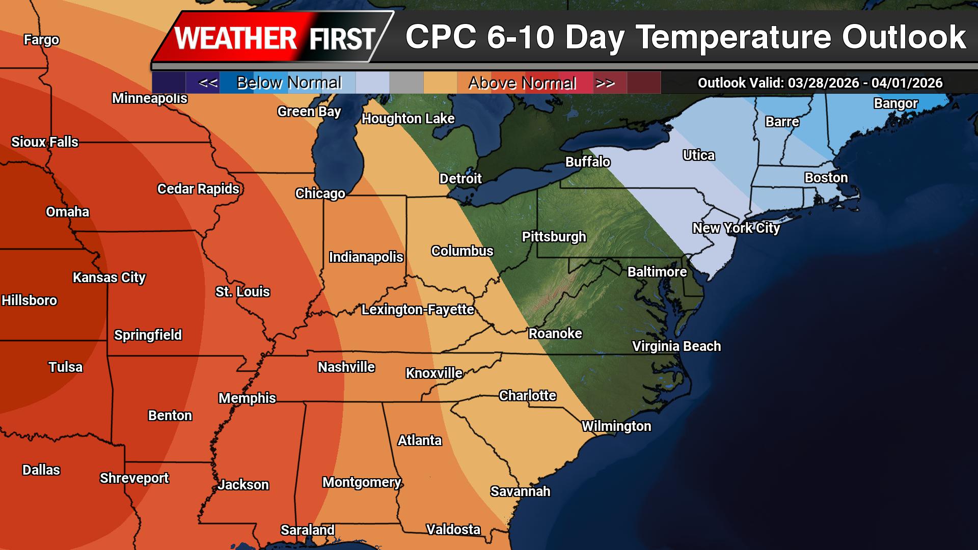
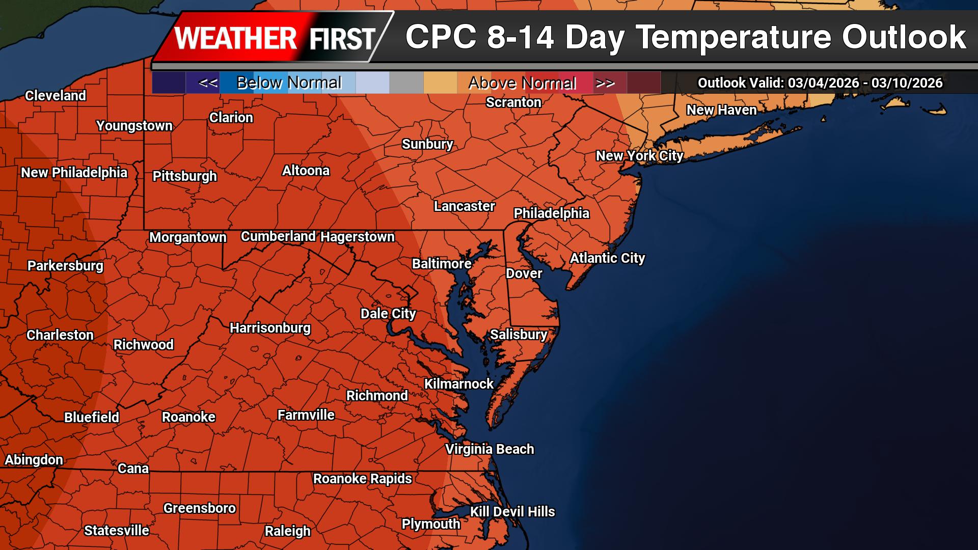
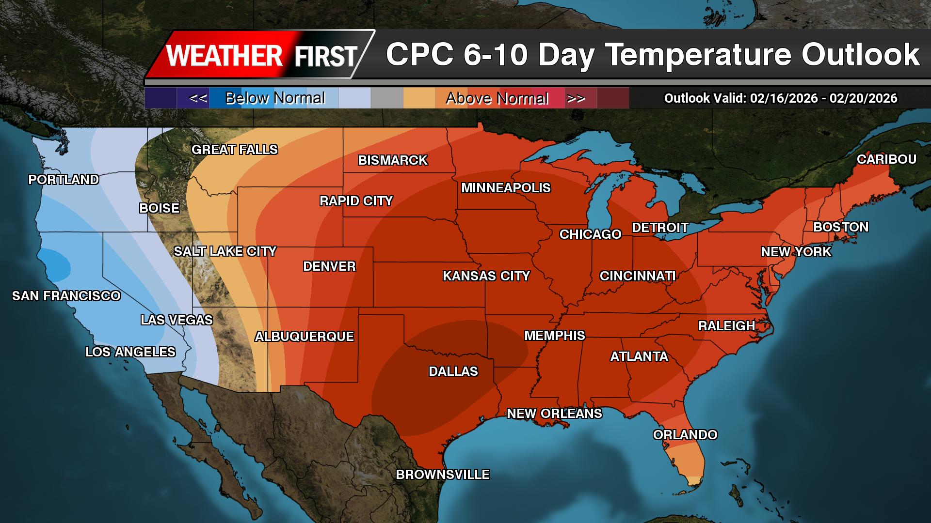
A changing weather pattern is expected across the Mid-Atlantic over the next couple of weeks, starting with a cooler stretch before transitioning to a milder setup heading into early April.
According to the Climate Prediction Center, an upper-level trough developing over the eastern United States will bring below-normal temperatures to the region during the 6 to 10 day period. This pattern supports a push of cooler air into the Mid-Atlantic, with temperatures running several degrees below average as we close out March.
This cooler period will be driven by persistent troughing along the East Coast and a reinforcing northwest flow aloft, allowing cooler air masses to settle into the region.
However, that pattern does not last.
As we move into the 8 to 14 day timeframe, the overall upper-level pattern begins to shift. The eastern trough weakens and lifts out, allowing heights to rise across the eastern United States. This transition opens the door for temperatures to rebound across the Mid-Atlantic, with a growing signal for above-normal temperatures developing.
In other words, after a cool end to March, a warming trend is expected to take hold as we head into early April.
Precipitation, meanwhile, remains somewhat limited through the period. The primary storm track is expected to stay displaced to the north, which favors below-normal precipitation overall across the Mid-Atlantic. While a few systems may pass through, widespread or prolonged rainfall does not appear likely at this time.
The overall takeaway: a cooler-than-normal stretch in the short term will give way to a milder and potentially warmer pattern heading into early April, with generally limited precipitation along the way.
A strong cold front is sweeping across the Delmarva Peninsula this morning, bringing a period of showers followed by a sharp drop in temperatures and increasing winds that will make for a raw and blustery day.
Early this morning, a disorganized but impactful system stretched from eastern Virginia to just off the coast near Cape May, helping to drive a band of steady showers across the region. This rainfall is expected to persist through the early morning hours before gradually tapering off by mid to late morning. However, the unsettled pattern doesn’t end there, as a secondary round of light showers or drizzle may develop around midday into the early afternoon.
Behind the departing system, a strong surge of cold air is quickly moving into the region. Temperatures will likely peak early in the day before steadily falling, dropping into the 40s and low 50s by late morning and afternoon. This cold air advection, combined with thick cloud cover, will create a noticeably colder feel compared to recent days.
In addition to the cooler air, winds will become a major factor. As the pressure gradient tightens between departing low pressure and building high pressure to the west, north to northwest winds will increase to 15 to 20 mph, with gusts reaching 25 to 35 mph throughout the afternoon. These gusty winds will enhance the chilly conditions, making it feel even colder across the peninsula.
Showers should come to an end by mid-afternoon, but skies are expected to remain mostly cloudy for much of the day, reinforcing the cool and damp feel.
Conditions improve tonight as winds gradually diminish and skies begin to clear. Sunshine returns for Tuesday, though temperatures will remain on the cooler side, signaling a quieter but still brisk stretch of weather across Delmarva.
The Delmarva Peninsula is set to enjoy a stretch of mild and quiet weather this weekend before a strong cold front brings a return to colder, breezier conditions to start the new week.
High pressure will keep conditions tranquil through Saturday and much of Sunday, with a steady warming trend underway. Afternoon highs on Saturday will reach the mid 50s to low 60s, followed by a milder night with lows only dropping into the low 40s. By Sunday, temperatures will climb even higher, with much of Delmarva seeing mid to upper 60s, and some locations potentially approaching or even reaching 70 degrees.
Clouds will begin to increase later Sunday as the next weather system approaches from the west. Showers are expected to develop Sunday afternoon and continue into Sunday night as a cold front moves toward the region. While widespread severe weather is not expected, there is enough atmospheric instability for a few isolated rumbles of thunder.
Rain chances across Delmarva will be somewhat lower compared to areas farther north, but periods of showers are still likely before tapering off by Monday afternoon as the cold front clears the coast.
Behind the front, a sharp change in conditions is expected. Colder air will quickly move in on Monday, with temperatures likely holding steady or even falling during the day. At the same time, gusty northwest winds will develop, with gusts potentially reaching 30 to 40 mph, creating a noticeably chillier feel.
The colder pattern will continue into Monday night, with temperatures dropping into the 20s and 30s, followed by highs only in the mid to upper 40s on Tuesday.
Looking ahead, temperatures will gradually moderate through the middle of next week, with additional chances for light rain returning by Wednesday into Thursday.
A mild but breezy day is unfolding across the Delmarva Peninsula as a fast-moving weather system tracks north of the region, bringing increasing winds, warmer temperatures, and a chance for evening showers.
Southerly winds are strengthening through the afternoon as the pressure gradient tightens ahead of an approaching cold front. Wind gusts are expected to reach 25 to 35 mph, especially during the mid to late afternoon hours. These gusty conditions are being driven by a strengthening low-level jet and improved daytime mixing, allowing stronger winds aloft to reach the surface.
Temperatures are responding accordingly, climbing into the lower to mid 60s inland, marking a noticeable warm-up compared to recent days. However, areas along the immediate coast will remain cooler due to persistent onshore flow off the still-chilly Atlantic waters.
Clouds will continue to increase through the day, with showers developing late this afternoon and becoming more widespread this evening as a weak cold front approaches. While the overall severe weather risk remains low across Delmarva, there is a slight chance of a thunderstorm, primarily west of the region. Most local impacts will be limited to periods of rain and brief heavier downpours.
Rainfall totals across Delmarva are expected to be relatively light, generally ranging from around 0.10 to 0.20 inches, though isolated higher amounts are possible in any heavier showers.
Conditions will improve overnight as the cold front pushes offshore, bringing an end to the rain and a gradual decrease in winds heading into early Saturday.
The latest U.S. Drought Monitor outlook shows a split pattern across the Mid-Atlantic, with some areas seeing improvement after recent rainfall, while others continue to dry out amid persistent warmth and long-term precipitation deficits.
Rain Brings Limited Relief to Northern Areas
Across the northern Mid-Atlantic, including Pennsylvania, New Jersey, and parts of Maryland, a widespread 0.5 to 2 inches of rainfall over the past week has helped improve drought conditions in some locations.
Locally higher amounts, topping 2 to 3 inches, were recorded in central and northeastern Pennsylvania and surrounding areas. This rainfall helped boost groundwater levels and ease longer-term precipitation deficits, allowing for modest improvement in drought classifications.
However, the relief has been somewhat tempered by unseasonably warm temperatures, which ran 9 to 12 degrees above normal across much of the region. These warmer conditions increase evaporation rates, limiting how effective the rainfall is in fully recharging soil moisture.
Drying Concerns Growing to the South
Farther south into Virginia and the broader Southeast, drought conditions are becoming more concerning.
In west-central Virginia, severe drought has expanded as soil moisture remains depleted and longer-term rainfall deficits continue to worsen. The same above-normal temperatures have only accelerated drying, increasing stress on soon to be planeted vegetation and water resources.
While isolated rainfall in parts of North Carolina brought minor improvement, it was not enough to significantly change the broader dry pattern.
Wider Regional Context
The Mid-Atlantic sits between two contrasting regimes:
To the north: Periodic storm systems are providing temporary relief
To the south:Persistent dryness and heat are driving worsening drought conditions
This transition zone places areas like Maryland and Delaware in a more uncertain position, where short-term rainfall may help, but longer-term deficits remain a concern heading into the spring growing season.
What This Means Going Forward
Despite recent rainfall in some areas, the overall trend suggests that consistent, widespread precipitation will be needed to fully reverse developing drought conditions.
If the current pattern of above-normal temperatures and inconsistent rainfall continues, parts of the Mid-Atlantic could see further drought expansion as we move deeper into spring.
For now, the region remains in a fragile balance, with improving conditions in some locations, but increasing drought pressure just to the south that could easily expand northward in the coming weeks.
After a stretch of cooler conditions, temperatures across the Delmarva Peninsula are set to moderate heading into the end of the week, with a brief taste of spring expected this weekend before cooler air returns early next week.
A warm front lifting through the region on Thursday will begin the transition, allowing temperatures to rebound into the upper 40s to low 50s. This marks a return to more seasonable conditions across Delaware and the Eastern Shore of Maryland.
The warming trend continues Friday as a stronger system passes north of the region. Southerly winds will increase, helping push highs into the upper 50s to near 60 degrees across much of Delmarva. A weakening cold front associated with this system will move through Friday night, bringing a period of light rain. Rainfall amounts are expected to remain on the lighter side, generally around a tenth to a quarter inch.
Heading into the weekend, conditions turn even milder. Saturday looks partly to mostly sunny with highs climbing into the low to mid 60s. By Sunday, even warmer air surges into the region ahead of the next approaching system, with temperatures reaching the mid to upper 60s inland. Coastal areas may stay slightly cooler due to onshore flow and the influence of colder ocean waters.
Another cold front is expected to cross Delmarva late Sunday into Sunday night, bringing a second round of scattered rain showers to end the weekend.
Behind this system, cooler Canadian air filters back into the region early next week. While temperatures will drop back closer to seasonal averages, conditions look dry and stable through at least midweek.
Overall, Delmarva will experience a classic early spring pattern: a brief warm-up with passing systems bringing light rain, followed by a return to cooler, quieter weather.
...NWS Damage Survey for 03/16/26 New Windsor, MD Tornado...

.New Windsor, MD Tornado...

Rating:                 EF-0
Estimated Peak Wind:    80 mph
Path Length /statute/:  1.68 miles
Path Width /maximum/:   150 yards
Fatalities:             0
Injuries:               0

Start Date:             03/16/2026
Start Time:             12:02 PM EDT
Start Location:         2 SSE Linwood / Carroll County / MD
Start Lat/Lon:          39.53609 / -77.12975

End Date:               03/11/2026
End Time:               12:05 PM EDT
End Location:           2 ESE Linwood / Carroll County / MD
End Lat/Lon:            39.55740 / -77.11459

Survey Summary:

A line embedded supercell developed and tracked over north-central
Maryland during the late morning into early afternoon hours on
Monday, March 16, 2026. This storm was part of a much larger system
that brought multiple rounds of severe weather to much of the
eastern United States.

Rotation was evident within the storm around 2000 to 3000 feet above
ground on the KLWX WSR-88D radar, prompting a Tornado Warning as the
storm moved from Frederick into Carroll County. The FAA TDWR TBWI
showed this rotation quickly strengthen and lower to below 2000 feet
just to the southeast of the mid-level mesocyclone being sampled by
the KLWX WSR-88D. The tightened lower-level rotation persisted on
TBWI for 1 to 2 minutes after the mid-level rotation on KLWX had
notably weakened.

It was beneath the tightening low-level rotation at around 12:02 PM
EDT that the first evidence of tornadic damage was found. Several
trees in a weakened state just southeast of the intersection of
Hawks Hill Road and Beth Way snapped near the trunk, and fell toward
the east, west, and north. The parent storm motion was northeast.
The trees that fell were only around 100 feet apart at most, with an
undisturbed landscape around it indicating an initially very narrow
vortex perhaps no larger than about 25 to 50 yards in width.

The tornado then crossed through open fields, lifting the south end
of a long irrigation system and rolling it about 100 feet toward the
north just east of Winters Church Road.

After this, the circulation continued northeastward crossing several
more fields and groves of trees, as well as Little Pipe Creek. The
next visible and accessible damage was noted as the tornado
approached and crossed MD-75 Green Valley Road near the intersection
with MD-84 Union Bridge Road. Here, a couple dozen trees fell in
opposing directions (southeast, northeast, east, northwest, and
north). One large tree toppled onto power lines taking down a power
pole and briefly trapping a motorist between the downed wires, pole,
and downed trees. Several large pine trees at the intersection had
their tops sheared off, falling toward the north, northeast, and
east. Two trees on a hill just east of Mill Dale Lane fell toward
the north-northwest, likely just outside the circulation but in its
inflow as it passed across MD-84 Union Bridge Road. Meanwhile, an
outbuilding just to the southwest of MD-75 Green Valley Road
suffered a near total roof collapse, with the west-northwest facing
walls partially collapsed inward. Similar to the trees off Mill Dale
Lane, this outbuilding may have been just outside the tornadic
circulation, with the damage a result of inflow winds into the
vortex as it passed. It is at this point where the tornado reached
its largest and strongest, with an estimated path width of 150 yards
and peak winds of 80 mph. Despite the extent of the damage, only
about one-third of the trees in its path at this point sustained
visible damage, with no other visible damage to other outbuildings
or the farmhouse at the nearby farm.

A video taken from the Carroll County Emergency Operations Center
showed a swiftly rotating lowering, likely the tornado in progress
as it approached and crossed the intersection of MD-75 Green Valley
Road and MD-84 Union Bridge Road, just northwest of their facility.
Although trees in the foreground obstructed the view and could not
confirm ground contact, the video was directly coincident with radar
and the observed (convergent) damage.

A few trees had their tops snapped off just northeast of MD-84 Union
Bridge Road, but no visible damage was noted beyond this point. It
is possible, based on the rotation signature on TBWI, that the
tornado could have persisted for up to another mile over open
fields, but the path length in this survey can only confidently
conclude a path up to this point, approximately 1.68 miles in length.

The National Weather Service Baltimore/Washington Weather Forecast
Office thanks Carroll County Office of Emergency Management for
their assistance. Additionally, thanks to the trained spotters,
media, and public that sent in reports of damage.

EF Scale: The Enhanced Fujita Scale classifies tornadoes into the
following categories:

EF0.........65 to 85 mph
EF1.........86 to 110 mph
EF2.........111 to 135 mph
EF3.........136 to 165 mph
EF4.........166 to 200 mph
EF5.........>200 mph
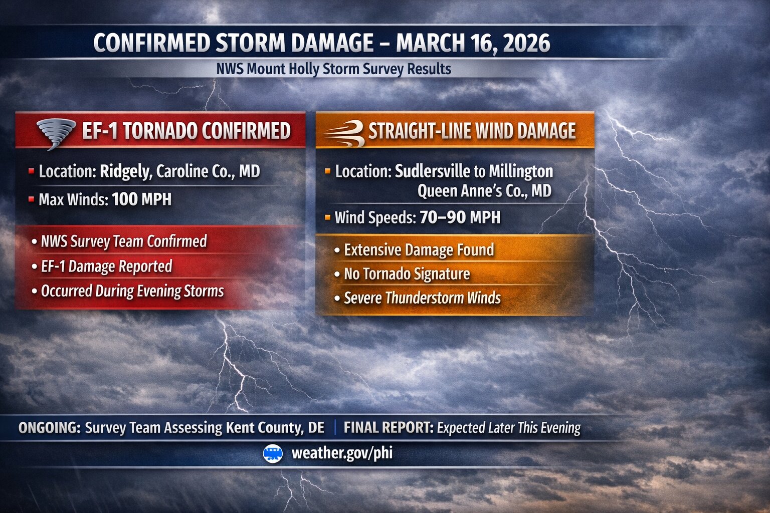
A powerful line of storms swept across the Delmarva region Monday evening, leaving behind a trail of damage now confirmed by the National Weather Service as a mix of tornadoes and destructive straight-line winds.
According to storm survey teams from the National Weather Service in Mount Holly, New Jersey, at least two EF-1 tornadoes touched down in the region, along with several corridors of intense wind damage reaching up to 100 mph.
One tornado was confirmed near Ridgely, Maryland, where winds between 90 and 100 mph carved a nearly one-mile path. Significant damage was reported, including a barn that was completely destroyed, debris thrown hundreds of yards, and numerous large trees uprooted or snapped.
A second EF-1 tornado was confirmed near Frederica, Delaware, with a shorter path of about 0.7 miles. Damage in this area was primarily to trees, along with a shed that was destroyed after being struck by a falling tree.
In addition to the tornadoes, multiple areas experienced intense straight-line wind damage, some of which rivaled tornado strength.
Photo from Magickal Mal
Near Camden, Delaware, winds were estimated between 90 and 100 mph, where several trees were snapped and fell onto mobile homes. One injury was reported in this area.
Further west in Queen Anne’s County, Maryland, a large swath of wind damage stretched nearly two miles from near Sudlersville toward Millington Road. Here, winds between 80 and 90 mph snapped power poles, tore metal roofing from farm buildings, and caused widespread tree damage.
Another concentrated pocket of wind damage was observed just south of Ridgely, Maryland, where winds up to 90 mph destroyed part of a farm outbuilding and scattered debris across nearby fields.
Outside of these hardest-hit areas, much of the region experienced widespread wind damage in the 60 to 70 mph range, consistent with the passage of a strong cold front.
Fortunately, no fatalities were reported, though the storms serve as a reminder of how quickly severe weather can intensify across the Mid-Atlantic.
The National Weather Service notes that this information remains preliminary and could be refined further as additional analysis is completed.
After a stretch of below-normal temperatures, conditions across the Delmarva Peninsula are set to gradually improve heading into the end of the week and the upcoming weekend. However, this warming trend will come with a few weak weather systems bringing occasional chances for light rain before cooler air returns early next week.
Through Thursday, quiet weather will dominate the region. Expect a mix of clouds and dry conditions, with temperatures remaining below average for mid-March.
A transition begins Thursday as a warm front lifts northward across Delmarva. This will allow temperatures to rebound closer to seasonal norms, rising roughly 7 to 10 degrees compared to midweek levels. Despite the warming trend, this system is not expected to produce any precipitation locally.
By Thursday night, a weak cold front passes to the north of the region. While this system may bring light rain and even some snow well north and west of the I-95 corridor, Delmarva will likely only see minimal impacts, with perhaps a spotty shower at most.
The warming trend continues into Friday as that boundary lifts back north. Temperatures will climb a few degrees higher, with another weak system approaching Friday night. This could bring a slight chance of light rain, but once again, the better chances for measurable precipitation appear to stay north and west of the peninsula.
Heading into the weekend, warmer air becomes more firmly established. By Saturday and especially Sunday, much of Delmarva is expected to see temperatures rise into the middle to upper 60s, providing a noticeable break from the recent chill.
The next more organized system arrives late Sunday into Sunday night, as a cold front pushes through the region. This will bring a better chance for scattered showers across Delmarva before moving offshore.
Behind this front, cooler and drier air returns to start the new week. Temperatures will fall back to more seasonable levels on Monday, with a reinforcing push of colder Canadian high pressure arriving by Tuesday. This will bring another period of below-normal temperatures to the region.
Overall, the pattern remains relatively quiet, with no significant storms expected, but periodic light rain chances and temperature swings will define the forecast over the next several days.
...CONFIRMED EF-1 TORNADO IN KENT COUNTY DELAWARE...

The survey team from the National Weather Service office has
confirmed a tornado occurred Monday evening near Frederica,
Delaware (Kent County). The preliminary rating is an EF-1 with
estimated maximum wind speed of 100 mph.

Additional extensive wind damage near Camden Delaware remains
under review. Preliminary estimate of maximum wind speed in this
area is 100 mph. A determination if this was straight line wind or
tornado damage will be coming later.

Previously the survey team had confirmed a tornado occurred Monday
evening in Ridgely, Maryland (Caroline County). The preliminary
rating of this tornado is an EF-1 with maximum winds to 100 mph.

The survey team also examined significant wind damage that
occurred between Sudlersville and Millington in Maryland (Queen
Anne's County). The preliminary result is that extensive straight-
line winds occurred with speeds between 70-90 mph.

A final assessment including all of the details are expected to
be completed and transmitted via a Public Information Statement
on Wednesday.

The storm survey information will also be available on our
website at http://www.weather.gov/phi
..CONFIRMED EF-1 TORNADO IN CAROLINE COUNTY MARYLAND… …EXTENSIVE STRAIGHT-LINE WIND DAMAGE CONFIRMED IN QUEEN ANNE’S COUNTY MARYLAND…
A survey team from the National Weather Service office in Mount Holly, New Jersey has confirmed a tornado occurred last night in Ridgely, Maryland (Caroline County). The preliminary result is an an EF-1 with maximum winds to 100 mph. The survey team also examined significant wind damage that occurred last night between Sudlersville and Millington in Maryland (Queen Anne’s County). The preliminary result is that extensive straight-line winds occurred with speeds between 70-90 mph. The survey team is currently in Kent County, Delaware.
A final assessment including all of the details are expected to be completed and transmitted via a Public Information Statement sometime this evening. The storm survey information will also be available on our website at http://www.weather.gov/phi
A powerful line of storms swept across the Delmarva Peninsula late Monday night, producing widespread damaging wind gusts across both Delaware and Maryland. Reports from the National Weather Service show several locations experienced winds over 60 mph, with a few spots nearing hurricane-force strength.
The strongest wind gusts were reported in Kent County, Delaware, where both 1 NE Magnolia and SR1 at Trap Shooters Road measured peak gusts of 73 mph. Winds of that magnitude are capable of bringing down trees, damaging power lines, and causing structural damage.
Other strong reports across Delaware included 68 mph in Bethel, 66 mph at Delaware Airpark, 66 mph at Dover Air Force Base, and 61 mph at Delaware Coastal Airport. Along the coast, Lewes and Dewey Beach both reached 58 mph.
In Maryland, the highest measured gust was 67 mph near Galena in Kent County. Other notable reports included 62 mph near Rock Hall, 61 mph near Queen Anne, and several additional gusts in the 50 to 60 mph range across Caroline, Queen Anne’s, and Talbot counties.
Much of the damage from this event appears to be consistent with straight-line winds, but National Weather Service Meteorologists are also closely examining whether a few embedded tornadoes may have occurred within the line of storms, especially across Kent County, Delaware, and Caroline County, Maryland. These types of quick spin-up tornadoes can develop within a fast-moving squall line and may be difficult to distinguish from damaging thunderstorm winds based on initial reports alone.
Photos from Alyster Jay & Kyle Guesfeird
At this time, the main damage reports have involved trees down and structural damage, which can occur from either intense straight-line winds or brief tornadoes. Additional storm surveys and damage assessments may be needed to determine whether any tornadoes touched down.
Meteorologically, this event was driven by a strong cold front and a powerful line of thunderstorms that tapped into stronger winds just above the ground and brought them down to the surface. That created a widespread corridor of damaging winds across the region, with many areas experiencing severe thunderstorm-force gusts well above 58 mph.
Even outside the hardest-hit areas, many locations still reported gusts between 40 and 50 mph, adding to hazardous travel conditions and scattered damage concerns overnight.
Residents in Kent and Caroline Counties who experienced storm damage are encouraged to share reports, especially where there may be evidence of concentrated or convergent damage. That information can help determine whether the damage was caused solely by straight-line winds or if embedded tornadoes were involved.
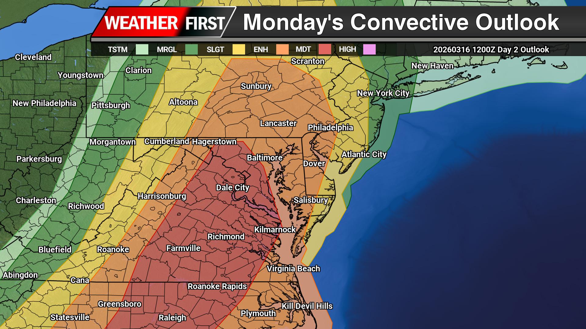
A potentially dangerous severe weather outbreak is expected to unfold Monday across parts of the Southeast and Mid-Atlantic, including Virginia, Maryland, and the Delmarva Peninsula. Forecasters warn that conditions may support widespread severe thunderstorms capable of producing destructive winds and tornadoes, some of which could be strong.
The Storm Prediction Center has placed portions of the region in a Moderate Risk (Level 4 of 5) for severe thunderstorms. This level of risk is relatively uncommon and indicates a higher likelihood of significant severe weather, including the potential for strong tornadoes and widespread damaging wind events.
Powerful Storm System Moving Into the East
The severe threat will be driven by a powerful storm system developing over the central United States. An expansive upper-level trough stretching from the Midwest into the southern Plains will rapidly intensify as it moves northeast toward the Appalachian Mountains. At the surface, a deep area of low pressure over the Great Lakes will track into eastern Canada while dragging a sharp cold front across the eastern United States.
Ahead of this cold front, warm and humid air will surge northward along the East Coast. Dew points climbing into the mid to upper 60s will provide ample moisture for thunderstorm development, while strong winds throughout the atmosphere will create an environment favorable for organized severe storms.
Tornadoes and Damaging Winds Possible
Across the Southeast and Mid-Atlantic, thunderstorms are expected to develop along and ahead of the advancing cold front during the day Monday. Some storms may initially form as discrete supercells, which are capable of producing large hail and tornadoes, including the potential for strong tornadoes.
As the afternoon progresses, storms are expected to organize into a line of thunderstorms, often referred to as a quasi-linear convective system (QLCS). This type of storm structure can produce widespread damaging wind gusts, while still maintaining the potential for embedded tornadoes within the line.
Strong winds just above the surface will enhance the rotation potential within storms. Even with only modest instability, these strong wind fields could allow storms to intensify quickly and produce severe weather across a large portion of the region.
Mid-Atlantic Threat Developing During the Afternoon
Farther north into Virginia, Maryland, and nearby areas, the amount of instability remains somewhat uncertain due to possible cloud cover and earlier precipitation. However, even relatively weak instability combined with very strong wind shear may still be sufficient to support severe thunderstorms.
Storms are expected to organize into a broad line extending from parts of New York and Pennsylvania southward through Virginia and North Carolina during the midday and afternoon hours. Within this line, embedded rotating storms could produce tornadoes and pockets of intense wind damage.
Severe Threat May Diminish Near the Coast by Evening
As the line of storms pushes east toward the Atlantic coastline Monday evening, the severe threat may gradually weaken as storms interact with cooler marine air near the coast. However, damaging winds and isolated tornadoes could still occur before the storms move offshore around sunset.
Preparedness Encouraged
With the potential for widespread severe weather, residents across the region should remain alert to changing conditions Monday. Multiple rounds of storms may occur, and warnings could be issued with little lead time if tornadoes develop.
Make sure you have multiple ways to receive weather alerts and be prepared to take shelter quickly if severe thunderstorms or tornado warnings are issued.
A rapidly strengthening storm system is expected to bring the potential for strong to severe thunderstorms across portions of the Mid-Atlantic on Monday, including parts of Maryland, Delaware, and Virginia.
We are closely watching the evolving setup, which could lead to a volatile day of severe weather across the eastern United States, particularly from the Carolinas northward into the Mid-Atlantic.
The storm system will begin organizing this weekend as low pressure develops on the eastern side of the Rocky Mountains. As the system strengthens and lifts northeast toward the Great Lakes, the upper-level trough associated with it is expected to turn negatively tilted, a configuration that often signals a strengthening storm system.
By Monday morning, a warm front is forecast to lift north through the Mid-Atlantic, placing much of the region into the warm sector of the storm. This will allow warmer temperatures and increasing humidity to spread northward, with dew points rising into the 60s as southerly winds transport a deep plume of moisture into the region.
At the same time, the atmosphere will become increasingly dynamic. Forecast guidance shows strong height falls aloft and a powerful upper-level jet stream positioned over the Mid-Atlantic. These ingredients will help promote rising motion in the atmosphere and the development of thunderstorms.
While atmospheric instability may be somewhat limited due to cloud cover and early-day showers, the strength of the wind fields and large-scale dynamics could compensate for that limitation. Strong low-level wind shear ahead of the approaching cold front may allow thunderstorms to organize quickly Monday afternoon and evening.
The primary threat with these storms will be strong to damaging wind gusts, though a few tornadoes cannot be ruled out, especially if individual storms are able to form ahead of the main line of convection.
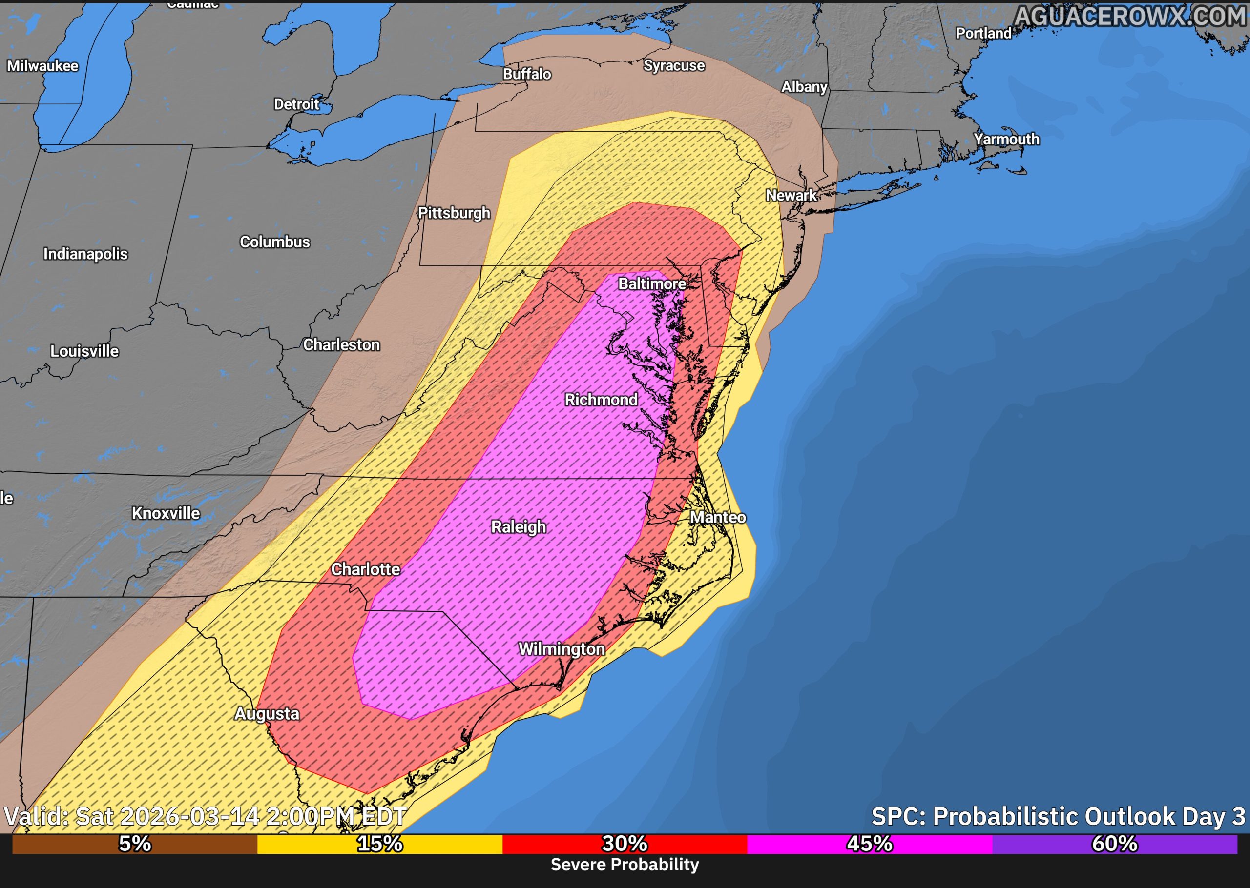
Scattered to widespread severe storms are possible across the Southeast and Mid-Atlantic on Monday. The corridor with the greatest potential for more significant severe weather currently appears to extend from South Carolina northward into Maryland, placing parts of the Mid-Atlantic near the northern edge of the higher-risk zone.
SPC Forecasters also note that this could become a very volatile severe weather day, and portions of the region from South Carolina to Maryland may even warrant an upgrade to a Level 4 Moderate Risk in later outlooks if confidence increases in the severe storm setup.
Storm modes could include a mix of discrete supercells ahead of the front as well as a fast-moving squall line. Embedded circulations within the line could enhance the tornado threat as storms move east toward the coastal plain.
In addition to the severe weather threat, the system will also bring the potential for periods of heavy rainfall. Precipitable water values are forecast to climb between 1.1 and 1.4 inches, which is above the 90th percentile for early March. While widespread flooding is not currently expected, locally heavy rain could lead to quick rises on small streams and rivers.
We will continue to refine the forecast in the coming days as the timing of the cold front and the amount of daytime heating become clearer. These factors will play a key role in determining how intense the storms become.
Residents across the Mid-Atlantic should stay weather aware on Monday and be prepared for the possibility of rapidly changing weather conditions during the afternoon and evening hours.
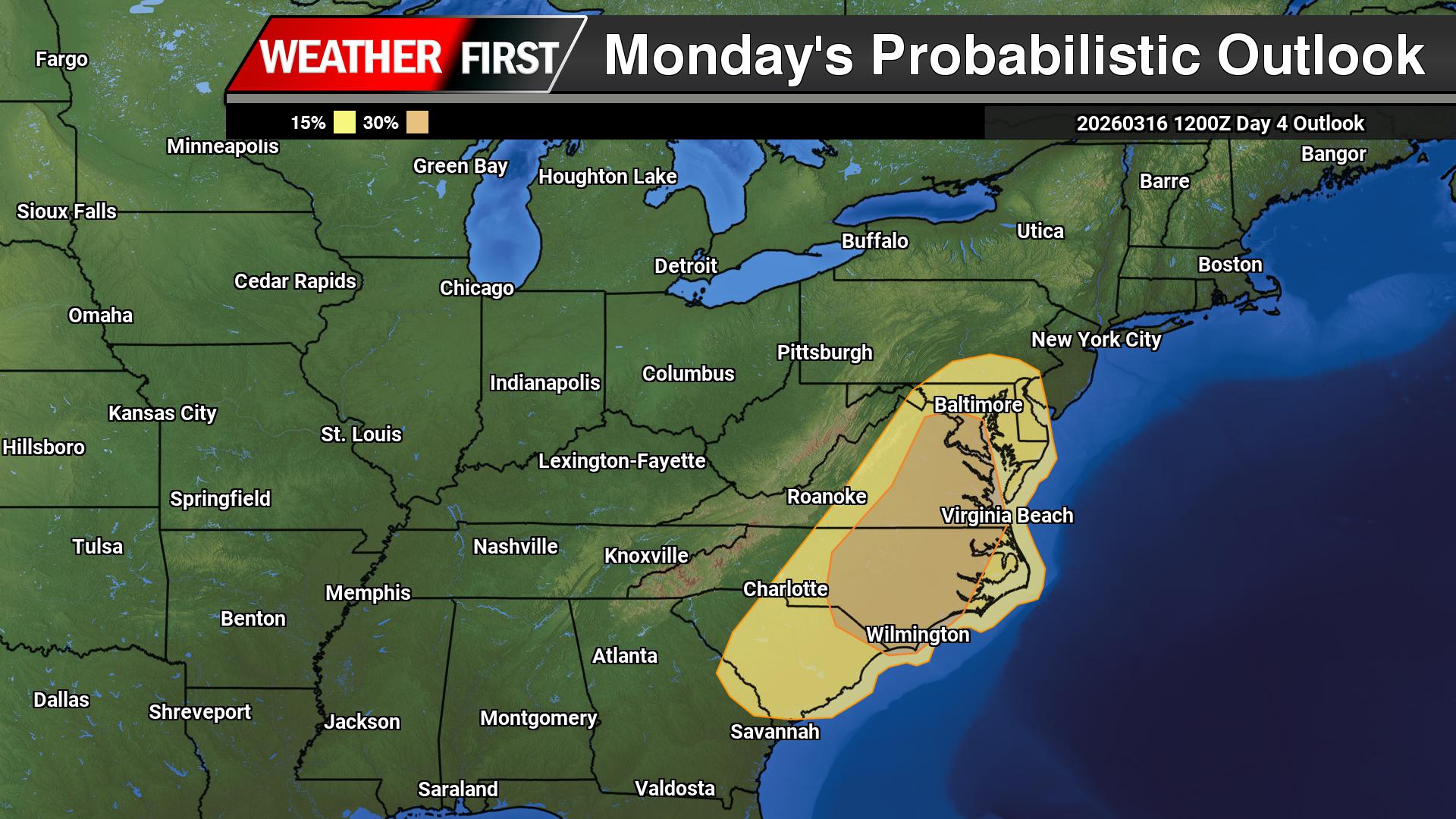
A potent storm system is expected to bring the potential for severe thunderstorms across the Mid Atlantic on Monday, including portions of the Delmarva Peninsula. Forecasters are becoming increasingly concerned about the risk for significant damaging winds as a powerful cold front sweeps east through the region.
The setup begins with a deep upper level trough moving out of the Mississippi Valley and toward the Great Lakes on Monday. As this system strengthens, surface low pressure will deepen while tracking north through the Great Lakes into Canada. Trailing behind the system, a strong cold front will move toward the East Coast and is expected to cross the Mid Atlantic Monday afternoon and evening.
Ahead of the front, strong southerly winds will transport warm and increasingly humid air into the region. A warm front lifting north will allow temperatures to climb into the 60s across much of the area, with some locations potentially reaching the lower 70s. At the same time, dew points will surge toward 60 degrees, creating a more unstable and moisture rich environment ahead of the approaching cold front.
Showers are expected to develop Sunday night into Monday as warm air advection increases across the region. These showers will likely become more widespread through the day Monday as the large scale storm system approaches. Even with cloud cover and showers potentially limiting instability, the atmosphere will feature very strong wind fields capable of supporting organized severe storms.
The Storm Prediction Center has highlighted the potential for an enhancement of significant damaging winds across portions of the Mid Atlantic on Monday. Forecast models show extremely strong winds just above the surface, with winds at around 5,000 feet reaching 50 to 70 knots. When thunderstorms develop along the cold front, these winds could be transported down to the surface, producing corridors of damaging wind gusts.
In addition to the wind threat, the overall wind shear profile will be very favorable for storm organization. Forecast soundings show strong turning of winds with height, which may allow storms to rotate. If storms develop ahead of the cold front in the warm sector during the afternoon, a few supercells could form. These storms would have the potential to produce isolated tornadoes, especially from the Carolinas into eastern Virginia before moving northward.
The most likely severe weather scenario, however, involves a fast moving squall line developing along or just ahead of the cold front during the afternoon and evening. This line of storms could produce widespread damaging wind gusts, with embedded tornadoes also possible due to the intense low level wind shear.
Heavy rainfall will also accompany the storms as deep moisture moves northward into the region, with atmospheric moisture values climbing above one inch of precipitable water.
Once the cold front passes Monday night, conditions will change quickly. Much colder air will surge into the region on gusty northwest winds, bringing temperatures back closer to seasonal levels for Tuesday and Wednesday.
A strong storm system moving from the Mississippi Valley toward the East Coast could bring the potential for severe thunderstorms across parts of the Mid Atlantic on Monday.
Ahead of an approaching cold front, warm and humid air will surge northward with dew points climbing into the 60s. At the same time, strong southwesterly winds throughout the atmosphere will overspread the region, creating favorable conditions for organized thunderstorms.
The primary threat appears to be a line of thunderstorms developing along the advancing cold front, which could produce damaging wind gusts as it moves east through the region. Even though atmospheric instability may remain somewhat limited, the strength of the storm system and strong forcing along the front could still support severe weather.
There is also a more uncertain risk for isolated supercell thunderstorms ahead of the main line, particularly across parts of eastern Virginia and North Carolina where low level wind shear may be enhanced.
The Storm Prediction Center have highlighted portions of the Mid Atlantic with a 15 percent severe weather risk Monday, mainly due to the potential for damaging winds with the line of storms. Cloud cover and early day showers may limit instability, which could affect the overall severity of the storms.
A dramatic change in the weather is unfolding across the Delmarva region today as a strong cold front moves offshore, bringing gusty winds, falling temperatures, and the potential for rain to mix with wet snow later in the day.
The region began the morning unusually warm, with temperatures starting in the 60s and even low 70s in some areas. However, strong cold air advection behind the departing cold front is causing temperatures to steadily fall through the day. Readings will drop through the 50s and 40s during the morning before settling into the mid to upper 30s by this afternoon.
Periods of showers are expected early today. As the atmosphere continues to cool, an area of additional moisture will develop behind the front as a disturbance rides along the temperature boundary offshore. This will cause rain to expand across much of the region through the late morning and afternoon hours.
As colder air deepens across the Mid-Atlantic, rain may begin mixing with wet snow, and in some places could briefly change over to all snow during the afternoon. This scenario is most likely near and southeast of the I-95 corridor, which includes much of Delaware and Maryland’s Eastern Shore.
If a band of stronger lift develops later this afternoon, precipitation could briefly intensify. This would allow the atmosphere to cool more quickly and may lead to a faster transition from rain to snow for a short period.
Despite the possibility of wet snow, little to no accumulation is expected. The recent stretch of record warmth has left ground temperatures elevated, and air temperatures during the day will remain above freezing. At most, minor slushy accumulation could briefly occur on grassy or elevated surfaces during heavier bursts of precipitation, while roads should remain mainly wet. But the chances of that are quite low.
In addition to the falling temperatures, winds will become quite gusty behind the front. Strong mixing in the atmosphere will allow winds to gust between 30 and 40 mph at times today, especially during the morning hours immediately behind the frontal passage. These winds will add to the chill as temperatures continue to fall through the afternoon.
By late day, wind chills are expected to drop into the upper 20s to low 30s, creating a sharp contrast from the mild conditions experienced just yesterday. In fact, temperatures this afternoon will be roughly 40 to 50 degrees colder than yesterday afternoon across parts of the region.
Precipitation should taper off from west to east by late afternoon into early evening as the system pulls away. Skies may begin to clear tonight, although a few lingering snow showers cannot be ruled out in parts of northeastern Pennsylvania.
Temperatures tonight will fall into the upper 20s across much of the region as winds gradually diminish, bringing a cold end to what began as a very mild start to the day.
A strong cold front moving through the region early Thursday morning will bring a dramatic change in the weather across the Delmarva Peninsula, replacing the recent warmth with gusty winds and much colder temperatures through the day.
Behind the cold front, a surge of colder air will rapidly move in from the west. Temperatures will start the day relatively mild early Thursday morning, but readings will steadily fall throughout the day as the colder air takes hold. Many areas across Delmarva are expected to drop from the 50s during the morning into the 40s by the afternoon.
As the front moves offshore, a small disturbance riding along the boundary may produce a few additional showers across the region during the morning and early afternoon. Some forecast models suggest the possibility of rain briefly mixing with wet snow before ending, particularly as colder air deepens in the atmosphere. However, this scenario may be overdone as much drier air quickly moves in behind the front.
With the incoming dry air likely to shut down precipitation fairly quickly, any lingering showers should taper off from west to east through the day. Even if a brief rain and snow mix were to occur, temperatures will remain above freezing, meaning no snow accumulation is expected.
The most noticeable change on Thursday will likely be the wind. Strong northwest winds will develop behind the cold front as colder air pours into the region. Gusts are expected to reach between 30 and 40 mph through much of the morning and into the early afternoon hours. These winds will combine with falling temperatures to make conditions feel significantly colder compared to the mild weather earlier in the week.
Winds will gradually begin to ease later Thursday afternoon and into the evening, but the colder air will remain firmly in place.
By Thursday night, temperatures across Delmarva are expected to drop sharply, with overnight lows falling into the upper 20s to lower 30s by early Friday morning. The colder conditions will mark a stark contrast from the unseasonably warm weather experienced just a day earlier.
Residents across the Delmarva Peninsula should remain alert Wednesday afternoon and evening as a developing weather system may bring the potential for strong to severe thunderstorms before a powerful cold front sweeps through the region overnight.
A strengthening area of low pressure moving across the eastern Great Lakes this afternoon will track into southern Quebec tonight. As this system intensifies, it will drag a strong cold front eastward across the Mid-Atlantic, arriving in the Delmarva region late tonight into early Thursday morning.
Ahead of the front, a warm and increasingly humid air mass will settle across the region during the day Wednesday. Temperatures will climb well above normal, while dew points rise into the upper 50s and lower 60s. This combination of warmth and moisture will help create a favorable environment for thunderstorms to develop.
We are closely watching a pre-frontal trough expected to form over central Pennsylvania during the afternoon. Thunderstorms that develop along this feature could organize and move eastward into the Delmarva region by mid to late afternoon and into the early evening hours.
Strong winds in the atmosphere will help support organized storm development. Forecast models indicate wind shear values of around 40 to 50 knots, which can help storms organize into line segments capable of producing damaging wind gusts. Some storms may also produce small hail, generally around quarter size, and there is a low but non-zero chance that an isolated tornado could occur.
The overall severe weather threat will depend heavily on how much sunshine develops during the day. If clouds remain widespread or if morning showers limit daytime heating, the atmosphere may not become unstable enough to support stronger storms. However, if breaks of sunshine develop, particularly across southern and western parts of the region, storm intensity could increase.
Current guidance suggests that areas south and west of Philadelphia have the greatest potential for stronger storms. The Storm Prediction Center has placed these areas in a Slight Risk, or Level 2 out of 5, for severe weather. Closer to the coast, including parts of coastal Delaware and New Jersey, the threat is lower due to cooler marine air moving in from the Atlantic Ocean, which tends to stabilize the atmosphere.
After the initial round of thunderstorms moves through Wednesday evening, activity may decrease overnight with only scattered showers expected for a time. The main cold front is forecast to cross the region early Thursday morning. Most of the rain associated with the front appears likely to occur after the boundary passes, which should limit any additional severe weather threat.
Temperatures will remain unusually warm overnight until the cold front moves through. Once the front passes early Thursday morning, temperatures will begin to drop quickly, signaling the arrival of cooler air across the region to start the day.
A strong cold front is expected to move through the region late Wednesday night into early Thursday morning, bringing a period of showers and possibly a few strong thunderstorms.
Ahead of the front, warmer and more humid air will move into the area Wednesday. This could help showers and a few thunderstorms develop as the cold front approaches overnight. While a few storms could become strong, the overall threat for severe weather across Delmarva appears to be relatively lower.
One reason for the lower risk locally is the influence of the Atlantic Ocean. Water temperatures are still very cold this time of year, which creates a stable marine layer near the coast. This cooler, more stable air can weaken storms as they move east toward the Delmarva Peninsula.
The greater risk for stronger storms is expected to remain farther inland, mainly west of our area, where conditions will be more favorable for storms to stay organized with the threat of strong winds, some small hail and a limited tornado risk across Western Maryland.
Even so, residents across Delmarva should expect periods of showers and rounds of thunder late Wednesday night into early Thursday morning.
After the cold front moves through Thursday morning, temperatures will begin to fall during the day as much colder air moves in. In fact, the warmest temperatures Thursday may occur just after midnight before dropping into the 40s by late afternoon with gusty northwest winds.
Unseasonably warm air is moving into the region today as strong southerly winds bring a much milder and more humid airmass across Delmarva. Afternoon temperatures are expected to climb into the mid to upper 70s, putting some locations within reach of record high temperatures for this time of year. And a few isolated areas have a shot of near 80 degrees!
Winds will increase from the south to southwest with gusts up to 20 to 25 mph, helping push the warm air northward. Humidity will also increase, with dew points rising into the upper 50s and low 60s, making it feel more like late spring than early March.
Areas along the immediate coast will likely stay a bit cooler due to the southerly wind coming off the still-cold Atlantic Ocean, but inland communities could see temperatures approach daily records.
Cloud cover will gradually increase through the day Wednesday, and a few showers may begin developing later in the afternoon, especially across western parts of the region ahead of an approaching cold front.
After several days of unseasonably warm weather across the Delmarva Peninsula, a strong cold front is expected to sweep through the region Wednesday night into Thursday, bringing widespread showers and the possibility of a few thunderstorms.
The weather pattern will begin to turn more active by midweek as a potent upper-level trough moves east from the central United States. As this system approaches, large-scale lift in the atmosphere will begin increasing across the Mid-Atlantic during the day Wednesday.
The first showers may begin to develop Wednesday afternoon, mainly across areas north and west of the Interstate 95 corridor. Much of Delmarva should remain mostly dry during the daytime hours, though clouds will likely increase through the afternoon.
Rain chances will increase significantly Wednesday night as the main system approaches. A surface low associated with the upper trough is forecast to track north of the region through the Great Lakes and into southern Canada. Trailing behind that system will be a strong cold front, which is expected to move through the Mid-Atlantic early Thursday morning.
As the front approaches Wednesday night, a line of showers is expected to move across the region, bringing a period of widespread rainfall. While the overnight timing should limit the potential for severe weather, forecasters say there is still a slight chance for isolated thunderstorms due to some elevated instability in the atmosphere.
In addition to the rain, winds are expected to become increasingly gusty as the system moves through. Even outside of heavier showers, a strengthening wind field in the atmosphere could lead to occasional gusts across the region late Wednesday night and into Thursday.
Behind the cold front, rain will gradually taper off during the day Thursday as colder air begins filtering into the Mid-Atlantic. A few lingering rain or even brief snow showers cannot be ruled out later Thursday as temperatures fall.
This system will mark the end of the recent stretch of spring-like warmth, with cooler conditions expected to return to the Delmarva region heading into the end of the week.
A stretch of unusually warm weather is expected across the Delmarva Peninsula through Wednesday, with temperatures running well above average for early March and potentially approaching record levels in some locations.
The warm pattern is being driven by a stable upper-level weather pattern combined with high pressure positioned over the western Atlantic Ocean. This setup acts almost like a heat pump, allowing very mild air to surge northward into the Mid-Atlantic region.
As a result, daytime temperatures across much of Delmarva are forecast to climb into the low to mid 70s through midweek. That is roughly 20 to 25 degrees warmer than normal for this time of year. Overnight temperatures will also remain mild, with lows generally falling into the 40s and 50s.
The warm temperatures will be most noticeable inland across Delaware and Maryland’s Eastern Shore. However, communities along the Atlantic coast will stay noticeably cooler due to the influence of the chilly ocean waters. High temperatures near the beaches are expected to remain mostly in the 50s as a daily sea breeze develops during the afternoon hours.
While record temperatures appear unlikely on Tuesday, some locations could challenge or even break daily record highs by Wednesday if the warm air remains firmly in place.
Another feature of this mild pattern will be the development of fog, especially during the nighttime and early morning hours. Increasing moisture in the atmosphere combined with cool ocean temperatures will create favorable conditions for fog formation. Coastal areas will be most prone to fog, but it may spread farther inland overnight before dissipating each morning.
Despite the fog potential, the overall pattern remains quiet and stable through midweek, bringing a prolonged period of spring-like warmth to the Delmarva region.
The National Weather Service in Mount Holly, New Jersey has confirmed that blizzard conditions occurred across portions of coastal New Jersey and Delaware during the early morning hours of February 23.
According to a public information statement released Friday afternoon, sustained winds or frequent gusts of 35 mph combined with falling and blowing snow reduced visibility to less than a quarter mile for at least three hours in several locations. Counties meeting blizzard criteria include Middlesex, Monmouth, Ocean, Burlington, Atlantic, and Cape May in New Jersey, along with Sussex County in Delaware. Both inland and coastal sections of many of these counties experienced the conditions.
The National Weather Service notes that the verification data is still considered preliminary until it is finalized and officially entered into the NWS StormData database. Exact start and end times for the blizzard conditions will be documented once the verification process is complete.
Spring weather across the Mid Atlantic can be notoriously difficult to forecast, and one of the biggest reasons is the frequent appearance of backdoor cold fronts. These unique weather boundaries often bring sudden temperature changes, shifting winds, and coastal clouds that can dramatically alter the forecast across the Delmarva Peninsula.
What Is a Backdoor Cold Front?
A backdoor cold front is a type of cold front that moves in from the northeast rather than from the west or northwest, which is the typical direction for most cold fronts in the United States.
Instead of sweeping across the region from the interior of the country, these fronts originate over New England or the North Atlantic and slide southwestward down the coastline. As the front moves through the Mid Atlantic, cooler air from the ocean and coastal regions pushes inland, replacing warmer air that had previously moved northward.
This process often results in rapid temperature drops, especially near the coast. It is not uncommon for areas along the Delmarva coast to see temperatures fall 10 to 20 degrees within a few hours after a backdoor front moves through.
Why Backdoor Fronts Are Common in the Spring
Backdoor cold fronts become especially common during the spring months across the Mid Atlantic because of the strong temperature contrast between land and water.
During spring, the land across the Mid Atlantic warms quickly as the sun angle increases. However, the Atlantic Ocean and nearby bays remain much colder after the winter months. This temperature difference creates the perfect setup for cooler marine air to surge inland.
At the same time, strong high pressure systems often build over eastern Canada or New England during the spring. These high pressure systems drive cooler air southwestward along the coastline, pushing the front toward areas such as New Jersey, Delaware, Maryland, and Virginia.
Because the cooler air mass travels over cold ocean water, it is typically moist and stable, which often leads to low clouds, fog, and occasionally drizzle behind the front.
A Major Forecast Challenge for Delmarva
Backdoor cold fronts are particularly challenging to forecast for the Delmarva Peninsula because of the region’s geography. Surrounded by the Atlantic Ocean, Delaware Bay, and Chesapeake Bay, the peninsula sits in a location where marine air can easily influence temperatures.
One of the biggest forecasting difficulties is determining how far inland the cooler air will push. Sometimes the front stalls near the coast, leaving inland communities much warmer. Other times it surges rapidly across the peninsula, causing temperatures to fall dramatically.
For example, on some spring days it may be near 70 degrees in western Maryland while coastal Delaware remains stuck in the 40s or 50s under cloudy skies and northeast winds.
Another challenge is that these fronts often stall and move back and forth across the region. Small shifts in wind direction or pressure patterns can cause the boundary to drift north or south, which can quickly change temperatures, cloud cover, and precipitation chances.
The Role of the Ocean and Sea Breezes
The cold Atlantic waters also enhance the effects of backdoor fronts across Delmarva. Even after the front passes, persistent onshore winds and sea breezes can keep coastal communities significantly cooler than inland areas.
This marine influence is why coastal locations such as Rehoboth Beach, Ocean City, and Cape Henlopen often experience cooler temperatures and fog while inland areas like Georgetown, Salisbury, or Dover remain warmer.
A Defining Feature of Mid Atlantic Spring Weather
Backdoor cold fronts are one of the defining characteristics of spring weather across the Mid Atlantic. Their ability to dramatically change temperatures over short distances makes them a constant challenge for meteorologists and a frequent source of forecast uncertainty.
For residents across Delmarva, these fronts are the reason why spring forecasts can shift quickly from warm and sunny to cool, cloudy, and foggy within just a few hours.
Residents across the Delmarva Peninsula will need to adjust their clocks this weekend as Daylight Saving Time begins early Sunday morning, March 8.
At 2:00 a.m. Sunday, clocks will move forward one hour to 3:00 a.m., meaning most people will lose an hour of sleep but gain more daylight during the evening hours.
Daylight Saving Time is observed across most of the United States and is designed to make better use of daylight during the longer days of spring and summer. By shifting the clock forward, sunsets occur later in the evening, providing extended daylight for outdoor activities, travel, and commerce.
For the Delmarva region, the change will be noticeable immediately. Sunset times will move from the 6:00 p.m. hour to the 7:00 p.m. hour, with daylight hours continuing to increase as spring approaches.
While many smartphones and digital devices update automatically, officials recommend checking manual clocks, appliances, and vehicles before heading to bed Saturday night.
Safety officials also suggest using the time change as a reminder to check smoke detectors and carbon monoxide alarms, replace batteries if needed, and review emergency preparedness plans.
Daylight Saving Time will remain in effect until Sunday, November 1, when clocks will fall back one hour as Standard Time returns.
Although the time change has been debated in recent years, no federal changes have yet been implemented, meaning Americans will continue the long-standing tradition of “springing forward” each March.
A significant warm up is expected across the Delmarva Peninsula late this weekend and into the first half of next week, with temperatures climbing well above seasonal averages. Along with the warmer air, periods of showers and the potential for dense fog may also develop, especially near the coast.
The transition begins Saturday night as an upper level disturbance tracks well to the north of the region. A weakening cold front trailing from this system is expected to move through the Mid Atlantic, bringing the chance for scattered showers and possibly a thunderstorm Saturday night into early Sunday. While the system will provide some lift in the atmosphere, meteorologists say the forcing may weaken as it moves eastward, which could limit how widespread the rainfall becomes.
Temperatures on Saturday may remain somewhat cooler during the daytime hours due to lingering colder air near the surface. However, warmer air moving into the region ahead of the weakening front will gradually erode that colder air mass from south to north. Because of this, temperatures may actually peak Saturday evening rather than during the afternoon.
By Sunday and Monday, the region will become fully embedded in a much warmer air mass. High pressure anchored over the western Atlantic will establish a steady south to southwest flow, allowing significantly warmer air to surge into the Mid Atlantic.
High temperatures are expected to climb into the 60s across much of Delmarva Sunday and Monday. The warmth intensifies further by Tuesday and Wednesday, when many areas could see highs reach the low to mid 70s.
However, coastal communities may experience some cooling due to the influence of the chilly Atlantic Ocean. Light southerly winds could allow a sea breeze to develop, especially during the afternoon hours, bringing cooler temperatures inland near the Delaware and Maryland beaches as well as along Delaware Bay.
Forecast models suggest a cold front may approach the region by Wednesday along with a possible area of low pressure. If this system arrives sooner than expected, temperatures may not reach the 70s in some locations. Behind the front, cooler air is expected to return by Thursday, although temperatures should still remain slightly above normal for early March.
In addition to the warmer weather, fog could become a recurring issue across the region. The combination of the milder air mass and increasing humidity moving over the colder ocean waters creates favorable conditions for fog formation. Some of the fog could become dense at times, particularly near the coastline and around Delaware Bay.
Drivers are urged to remain cautious during periods of reduced visibility, especially during the overnight and early morning hours when fog tends to be most widespread.
Overall, the upcoming pattern represents a notable shift toward springlike conditions after the colder weather that has dominated much of the winter season across the region.
The latest U.S. Drought Monitor, released Thursday, shows drought conditions continuing across portions of the Delmarva Peninsula, although impacts vary depending on location across Delaware, Maryland’s Eastern Shore, and the lower Eastern Shore of Virginia.
According to the newest data, areas of moderate drought (D1) remain across parts of the lower Maryland Eastern Shore and nearby sections of the Mid Atlantic. Meanwhile, other portions of the Delmarva region are classified as abnormally dry (D0), indicating lingering moisture deficits but not yet reaching official drought status.
The U.S. Drought Monitor categorizes drought into several levels, ranging from D0 (abnormally dry) to D4 (exceptional drought). Areas in the D0 category are often experiencing short term dryness or recovering from drought conditions, while D1 indicates more significant moisture deficits that can begin to impact agriculture, water supplies, and ecosystems.
Delmarva Conditions
Across the Delmarva Peninsula, drought conditions have been driven largely by several months of below normal precipitation, which has led to declining groundwater levels, reduced streamflow, and drier soils in some areas. Long term precipitation deficits in parts of Delaware have ranged several inches below normal over the past six months, contributing to the ongoing dryness.
The latest assessment shows the most notable drought conditions focused across portions of the Maryland Eastern Shore, while parts of Delaware and the Virginia Eastern Shore remain mostly in the abnormally dry category or near normal conditions.
Impacts Across the Region
Even moderate drought can have noticeable impacts across Delmarva. Dry soils can affect early season agriculture, groundwater recharge, and local water supplies. In addition, periods of dry and windy weather can increase the risk of brush and vegetation fires, particularly during late winter and early spring when vegetation is dormant.
Officials in parts of the Mid Atlantic have previously issued drought advisories and warnings due to these ongoing dry conditions, especially where streamflow and groundwater levels remain below normal.
After a stretch of gloomy and cool weather, a significant warm up is expected to develop across the Delmarva Peninsula this weekend and continue into the first half of next week. Forecasters say temperatures could surge well above normal as a much milder air mass spreads into the Mid Atlantic.
The transition begins later this weekend as a ridge of high pressure builds over the western Atlantic Ocean. At the same time, several upper level disturbances will track across the northern United States, helping to set up a pattern that allows warmer air to gradually move northward into the region.
Before the warmer air fully arrives, cooler conditions may linger into Saturday due to a setup known as cold air damming. Strong high pressure over eastern Canada will push cooler air southward into the region, while a boundary remains positioned to the south and west of Delmarva. This could keep skies cloudy with areas of fog and cooler temperatures early in the weekend.
As the weekend progresses, the colder air mass will begin to erode from south to north. This process may lead to a sharp temperature difference across the region on Saturday before warmer air eventually takes over. Some showers may also develop Saturday night as a disturbance passes to the north and a trailing cold front approaches. A stray thunderstorm cannot be ruled out, although widespread severe weather is not expected.
By Sunday, much of the Delmarva region will become firmly established within the warmer air mass as high pressure settles offshore. Winds shifting to the south and southwest will help draw warmer air northward.
Temperatures are expected to climb into the 60s across much of the region Sunday and Monday. Even warmer conditions are likely by the middle of next week, when highs could reach the low to mid 70s on Tuesday and Wednesday. These readings would be 10 to 20 degrees above average for early March.
Communities along the coast may see somewhat cooler temperatures due to developing sea breezes off the Atlantic Ocean and Delaware Bay. This could keep coastal locations several degrees cooler than inland areas.
The warm pattern may not last indefinitely, however. Forecast models suggest a cold front could approach the region around Wednesday, bringing another chance of showers and potentially preventing temperatures from reaching the warmest projections.
Even so, the overall trend points toward a dramatic shift from recent chilly conditions to a stretch of springlike warmth across the Delmarva Peninsula during the upcoming week.
Governor Matt Meyer has officially proclaimed March 9 through March 13, 2026 as Severe Weather Awareness Week in Delaware, encouraging residents across the First State to prepare for potentially dangerous weather events that can occur throughout the year.
The initiative is led by the Delaware Emergency Management Agency (DEMA) in partnership with the National Weather Service, the University of Delaware’s Center for Environmental Monitoring and Analysis (CEMA), the Delaware Department of Transportation (DelDOT), and Delaware Sea Grant. The goal is to increase awareness about severe weather threats and encourage residents to take steps now to protect their families and communities.
State officials say the week serves as a reminder that Delaware regularly faces weather hazards such as flooding, tornadoes, severe thunderstorms, lightning, and coastal storms. Many of these events can develop quickly, giving residents little time to react without proper preparation.
Daily Severe Weather Safety Topics
Throughout the week, emergency management officials will focus on a different severe weather hazard each day, sharing safety tips and preparedness information.
Monday: Flood safety
Tuesday: Tornado safety
Wednesday: Severe thunderstorms and hail
Thursday: Lightning safety
Friday: Preparing for severe weather
Residents are encouraged to follow along on social media and online resources to learn how to respond when severe weather strikes.
Recent Severe Weather Highlights Need for Preparedness
Delaware has experienced several significant weather events in recent years that highlight the importance of preparedness.
In 2020, the remnants of Tropical Storm Isaias produced the longest tornado ever recorded in Delaware, carving a destructive path from Dover in Kent County to Glasgow in New Castle County. More recently, a tornado in Sussex County in April 2023 resulted in the state’s first tornado-related fatality in decades.
Flooding has also been a growing concern. The remnants of Hurricane Ida produced historic rainfall and flooding in Wilmington in 2021, underscoring the risks associated with extreme weather across the region.
Nationally, severe weather continues to cause major impacts. According to federal climate data, the United States recorded 27 separate billion-dollar weather disasters in 2024, with the majority tied to severe thunderstorms.
Steps Delaware Residents Can Take Now
Emergency management officials say preparedness before severe weather strikes is critical. Residents are encouraged to:
Sign up for alerts through the Delaware Emergency Notification System (DENS)
Build a basic emergency preparedness kit
Create a family emergency plan
Know evacuation zones and local hazards
Stay informed through weather alerts and trusted forecasts
More preparedness information and resources are available at PrepareDE.org.
Officials say even small steps taken ahead of severe weather can significantly reduce risks to lives and property when dangerous conditions develop.
A stretch of gloomy weather is expected to continue across the Delmarva Peninsula through Friday as a stalled frontal boundary keeps the region locked into cool, damp conditions.
The front will remain positioned mostly south of the region, allowing several weak areas of low pressure to move along it. These disturbances will periodically bring light rain or scattered showers while maintaining a very moist air mass over the area.
The first round of rain arrived early Thursday morning, with another wave expected to move through later tonight. Between these periods of rainfall, mist and drizzle are likely to develop, along with areas of fog as light winds and abundant moisture linger across the region.
Patchy dense fog will remain a concern at times through Friday. However, forecasters note that winds may stay just strong enough to prevent widespread dense fog development. Melting snow and warming ground temperatures may also help reduce the risk somewhat, though localized visibility reductions are still possible, particularly during the overnight and early morning hours.
As a result, conditions may remain murky across much of the Delmarva Peninsula with low clouds and periods of reduced visibility.
The unsettled pattern continues into Friday as a backdoor cold front pushes into the region from the north and east before stalling across Delmarva. This setup will trap low-level moisture beneath a temperature inversion, leading to persistent cloud cover along with occasional drizzle, light showers, and areas of fog.
Temperatures will stay on the cool side for early March, with afternoon highs across most of the region expected to remain in the 40s.
Cloudy, foggy conditions will continue across the Delmarva Peninsula today as a slow moving weather system lifts north through the region. A stationary front currently stretching from low pressure over the Ohio Valley across Delmarva and southern New Jersey will gradually begin to shift northward as a warm front through the day.
As this front lifts north, temperatures across the region will slowly rise. Afternoon highs are expected to reach the low 50s for many areas, with some locations across Delmarva potentially climbing into the upper 50s. Temperatures will remain relatively mild overnight as well, only dropping into the 40s.
Fog has been widespread across the region early today, although visibility has shown some improvement in some areas. Despite this, fog is expected to remain a concern through much of the day, particularly closer to the coast, Delaware Bay, and along the shoreline where it may remain thicker and more persistent. Motorists traveling in these areas should continue to exercise caution due to reduced visibility.
Later this afternoon and into the evening hours, a disturbance in the upper atmosphere combined with weak low pressure moving through the region may trigger scattered showers. The best chance for rain will be across the Delaware Valley, southern New Jersey, and the Delmarva Peninsula. While rainfall amounts are expected to remain relatively light, wet roads could add to the already challenging travel conditions caused by fog.
As the main low pressure system moves closer tonight, fog is expected to redevelop and cloud ceilings will likely lower once again. Another round of light rain may also develop late tonight as the system approaches. Overnight temperatures will remain mild, generally settling into the 40s across the region.
The unsettled and damp conditions are expected to linger into Thursday as the slow moving weather pattern continues to influence the Mid-Atlantic.
A significant shift in the overall weather pattern is setting the stage for a prolonged warm up across the Delmarva Peninsula beginning mid week and continuing into early next week. An upper level trough developing over the western United States will allow strong ridging to build over the eastern half of the country. As that western trough digs farther south into western Mexico by Friday, the ridge over the East will amplify. At the surface, a large Bermuda high will take control, promoting a milder southwest flow into the Mid Atlantic and pushing temperatures well above average for early March.
By Wednesday, highs across Delmarva will climb into the 50s to near 60 degrees. The forecast becomes more complicated from Thursday through Saturday as a frontal boundary wavers north and south across the region. The front is expected to lift north on Thursday before stalling and then dropping back south as a backdoor front Friday into Saturday. Its exact placement will create sharp temperature differences across relatively short distances. South of the boundary, temperatures will warm into the mid 60s to around 70 degrees, while areas near the front hover around 60. North of the boundary, highs may struggle in the 40s and 50s. There is increasing potential that some parts of Delmarva could trend cooler than currently forecast, particularly if a persistent east to northeast wind develops and pulls in cooler marine air from the Atlantic.
By Sunday and into early next week, the front is expected to lift back north, placing the region firmly in the warm sector once again. Highs should reach the 60s and lower 70s inland. Coastal communities, including areas along the Delaware Beaches and the Maryland and Virginia Eastern Shore, are likely to remain cooler in the 40s and 50s due to the influence of the cold ocean waters.
Although this pattern does not favor any significant storms, it will not be completely dry. The wavering boundary will serve as a focus for several weak disturbances moving through from Wednesday into Saturday, bringing multiple opportunities for showers. A slightly stronger wave Thursday night could even produce a few rumbles of thunder. Shower chances may linger into the weekend and early next week as the jet stream remains displaced well to the north.
Any rainfall that develops will be welcomed across Delmarva, where ongoing drought conditions have left soils dry. While this does not appear to be a soaking event, periodic showers could provide some short term relief as the region transitions toward spring.
Beginning today, March 3, 2026, the Storm Prediction Center is implementing significant changes to how severe weather risks are communicated in its daily convective outlooks.
The update does not change the familiar five tier categorical system used to describe overall severe weather risk. Instead, it enhances the outlooks by adding clearer information about the potential intensity of tornadoes, damaging winds, and hail, even in situations where storms may be limited in coverage.
The change is designed to improve how forecasters communicate high impact threats and help emergency managers, broadcasters, and the public better understand the severity of possible outcomes.
What Remains the Same
The SPC will continue to issue its well known categorical risk levels: Marginal Level 1, Slight Level 2, Enhanced Level 3, Moderate Level 4, and High Level 5.
These categories still represent the overall probability and expected coverage of severe thunderstorms within 25 miles of a point.
What Is New: Conditional Intensity Groups
The major addition is the introduction of Conditional Intensity Groups, also known as CIGs. These new markers appear within the probabilistic tornado, wind, and hail outlooks and are intended to show the maximum expected intensity of severe hazards if storms develop.
In previous outlooks, hatched areas indicated potential for significant severe weather but did not clearly differentiate between moderate and extreme scenarios. Now, distinct intensity tiers provide clearer hazard messaging.
Tornado Outlook Changes
Tornado forecasts now include three Conditional Intensity Groups.
CIG 1 indicates an environment supportive of tornadoes up to at least EF2 strength.
CIG 2 signals potential for strong tornadoes of at least EF3 intensity.
CIG 3 highlights an environment capable of producing violent tornadoes rated EF4 or stronger.
This is particularly important in conditional setups where storm coverage may be limited but atmospheric parameters strongly favor intense tornadoes. Under the old system, that nuance was more difficult to convey visually. Now, even on days with lower overall probabilities, SPC can communicate when the ceiling for tornado strength is especially high.
Damaging Wind Outlook Changes
Wind outlooks are also receiving expanded intensity detail.
Three wind intensity tiers are now included.
CIG 1 represents potential for gusts of at least 74 miles per hour.
CIG 2 indicates an environment supportive of organized bow echoes or derechos.
CIG 3 highlights an ongoing or highly likely derecho level event.
In addition, SPC is adding higher probability thresholds of 75 percent and 90 percent to Day 1 and Day 2 wind outlooks. These elevated percentages signal very high confidence in widespread damaging wind. This refinement allows forecasters to distinguish between scattered severe gusts and large scale, high impact wind events.
Hail Outlook Changes
Hail forecasts now include two distinct intensity tiers.
CIG 1 indicates potential for hail greater than 2 inches in diameter.
CIG 2 indicates potential for hail exceeding 3.5 inches in diameter.
The addition helps differentiate between typical severe hail events and environments supportive of extremely large, destructive hail often associated with long lived supercells.
Unlike tornado and wind outlooks, hail currently includes two tiers rather than three, reflecting the rarity and forecasting challenges associated with the most extreme hail sizes.
Why the Change Matters
The update enhances SPC’s ability to communicate risk in two critical ways. It separates coverage probability from maximum intensity potential. It also better highlights high end threats in conditional environments.
For emergency planners and broadcast meteorologists, this provides clearer decision support information. For the public, it offers a more precise understanding of how dangerous storms could become, not just how likely they are to occur.
The revised outlook format takes effect with today’s convective outlook issuance and will apply to Day 1, Day 2, and Day 3 severe weather forecasts.
Meteorological Winter 2025–26 will go down as one of the coldest and snowiest winters in over a decade for much of the Mid-Atlantic, including Delaware and the I-95 corridor. While snowfall was impressive, precipitation overall leaned slightly below average in many locations, making it a cold and snowy, but somewhat dry winter season.
Preliminary data from the National Weather Service shows that several cities experienced their coldest winter since the mid-2010s, and in some cases, the early 1990s.
A Historically Cold Winter
Across the region, average temperatures finished several degrees below normal.
In Georgetown, the average winter temperature was 33.8°F, which is 5.2 degrees below normal. This ranks as the 8th coldest meteorological winter since 1893-94, marking the coldest winter there in over three decades.
In Wilmington, the average temperature came in at 31.8°F, or 3.9 degrees below normal, making it the coldest winter since 2014-15.
Philadelphia, Allentown, Trenton, Reading, Mount Pocono, and Atlantic City all saw their coldest meteorological winter since at least 2014-15, while Atlantic City Marina experienced its coldest since the historic winter of 1993-94.
Snowfall: A Major Comeback Year
Snowfall was the headline story this winter, particularly along and north of the I-95 corridor.
In Wilmington, seasonal snowfall reached 24.0 inches, which is 7.2 inches above normal. This makes it the snowiest winter since 2013-14, breaking a decade-long stretch of relatively modest snowfall seasons.
Farther north, Trenton recorded 44.3 inches, ranking as the 6th snowiest winter on record. Philadelphia measured 30.1 inches, its snowiest winter since 2013-14.
Although snowfall data was not calculated for Georgetown’s seasonal totals, February alone brought impactful snow events, and nearby observing sites confirm this winter was significantly snowier than recent years across southern Delaware.
Precipitation: Snowy But Slightly Dry
Despite the frequent snow, total liquid precipitation was generally below normal in many locations.
Wilmington finished with 8.14 inches, about 1.77 inches below average. Georgetown, however, was one of the few spots to edge slightly above normal, finishing at 9.17 inches, just 0.11 inches above average.
This reflects the nature of the season: colder air masses favored snow production, but overall storm systems were not especially moisture-rich.
February Sealed the Deal
February reinforced the winter’s cold theme. Georgetown averaged 5.7 degrees below normal for the month, while Wilmington finished 3.4 degrees below average. Several late-month warmups pushed temperatures near 60 degrees, but they were not enough to offset persistent cold earlier in the season.
A noticeable pattern change will bring a significant warm-up to the Delmarva Peninsula beginning mid-week and continuing through the upcoming weekend, along with several opportunities for showers. After recent colder conditions, the large-scale setup across the United States is shifting. Upper-level troughing will deepen over the western part of the country while strong ridging builds across the East. At the surface, a large Bermuda high will take control, allowing much warmer air to surge northward into the Mid-Atlantic region.
As a result, temperatures are expected to run 10 to 20 degrees above normal by late week. Highs on Wednesday will climb into the low 50s to low 60s, followed by even warmer readings Thursday, when many areas reach the upper 50s to upper 60s. Some communities across Delmarva could even touch the low 70s. Friday’s forecast is slightly more complicated, as a back-door cold front dropping south from New England may briefly knock temperatures down compared to Thursday. Even so, highs should still reach the low 50s to low 60s, which remains above average for this time of year.
By the weekend, that boundary is expected to lift back north, placing Delmarva firmly back into the warm sector. Inland areas could see highs well into the 60s and 70s on Saturday and Sunday, offering a preview of spring. Coastal communities, however, will likely remain cooler, mainly in the 50s, due to chilly Atlantic water temperatures and occasional onshore flow.
In addition to the warmer air, several weak disturbances will move along a boundary stretched from the Ozarks to New England, bringing multiple chances for showers from Wednesday through the weekend. Rain chances will generally range between 30 and 60 percent during the week. A slightly stronger wave Thursday night may even produce a few rumbles of thunder. Shower chances continue into the weekend, though they appear lower overall, closer to 20 to 40 percent as the jet stream remains positioned well north of the region.
Overall, the pattern does not suggest any major storm systems or significant severe weather at this time. Instead, Delmarva can expect a stretch of well above normal temperatures paired with periodic, beneficial rainfall is welcome news given ongoing drought concerns in parts of the Mid-Atlantic.
Arctic high pressure will keep the Delmarva region locked in a stretch of below-normal temperatures through Tuesday, while a developing system to the south brings periods of light wintry precipitation.
Cold Start to the Week
High pressure centered over the eastern Great Lakes will gradually shift offshore tonight and settle over the western Atlantic by Tuesday. In the meantime, Delmarva will remain firmly under a cold air mass.
High temperatures today will struggle to reach the low to mid 30s, running roughly 10 degrees below seasonal averages. Winds will remain light, but the cold air will be firmly entrenched across the peninsula.
Light Snow Developing This Afternoon
As the high slides offshore, a developing area of low pressure over the Southern Plains will push a warm front northward toward the Mid-Atlantic.
Shortwave energy riding along that boundary is expected to trigger light snow across Delmarva this afternoon into early evening. A light coating of snow is possible, especially across the Eastern Shore of Maryland and Delaware. Any snow that develops should taper off later this evening.
Accumulations are expected to remain minor, generally less than an inch.
Wintry Mix Late Tonight into Tuesday
Attention then turns to late tonight into Tuesday morning as the warm front continues lifting north. With temperatures initially below freezing, precipitation will begin as snow across much of Delmarva.
Southern portions of the peninsula are expected to change over to plain rain fairly quickly overnight as slightly warmer air moves in. However, across northern areas of Delmarva, a brief period of wintry mix cannot be ruled out before transitioning to rain.
Any ice accumulation locally would be light, generally a glaze at most, with snowfall totals remaining under one inch.
Milder by Tuesday Afternoon
By Tuesday afternoon, temperatures should rise into the 40s across Delmarva, allowing all precipitation to change to plain rain.
While this is not expected to be a major winter event for the peninsula, brief slick spots are possible late tonight into early Tuesday before the changeover to rain.
A cold Arctic air mass will settle over the Delmarva region to start the week, setting the stage for two separate storm systems that could bring periods of wintry precipitation from Monday through Wednesday.
High pressure building south from Canada will lock in colder air across Delaware, Maryland’s Eastern Shore, and coastal Virginia on Monday and Tuesday. That cold air will be critical in determining precipitation type as the first of two systems approaches.
First System: Light Snow Possible Monday
The first wave of low pressure is expected to move east out of the Tennessee Valley on Monday, tracking along a stalled frontal boundary. Current guidance keeps this system somewhat suppressed to the south as it passes near the Chesapeake region.
For Delmarva, this setup could bring a period of light snow later Monday into Monday evening. However, confidence remains limited. Precipitation chances have decreased into the 20 to 40 percent range, and projected snowfall amounts have trended downward in recent forecasts. If snow does occur, it currently appears more likely to be light and limited in duration.
Second System: Higher Rain Chances Tuesday Into Wednesday
Attention then turns to a second disturbance expected to ride along the same boundary late Tuesday into Wednesday. Forecast models show better agreement that this system will impact the region, though some timing differences remain.
Unlike Monday’s system, temperatures are forecast to gradually warm Tuesday into Tuesday night as southerly winds develop. This could allow for a rain and snow mix at the onset, especially Tuesday evening, before transitioning to plain rain overnight into Wednesday.
Precipitation chances with this second system have increased into the 50 to 70 percent range, making it the more likely of the two systems to bring measurable precipitation to Delmarva.
The latest U.S. Drought Monitor update shows that drought and dry conditions remain a concern across much of the Mid-Atlantic region, with impacts continuing for agriculture, water resources and ecosystems.
While the national map shows pockets of improvement in some areas, large portions of the Mid-Atlantic remain classified at various levels of dryness and drought. The drought map uses a five-category scale from D0 (abnormally dry) to D4 (exceptional drought) to characterize conditions.
In the current monitoring period, significant parts of the region, including segments of Maryland, Virginia, Pennsylvania, and surrounding states, are still experiencing at least abnormally dry (D0) conditions. Some locales continue under moderate drought (D1) or more severe classifications, indicating lingering moisture deficits and reduced soil and streamflow conditions.
Precipitation over recent weeks has been below average, leading to limited relief from long-term dryness. Although brief rain events have occurred, they have not been widespread or persistent enough to significantly improve drought conditions across much of the watershed.
Experts note that conditions vary locally, and short-term rains may bring modest improvement in some areas. However, until more widespread rainfall occurs, drought and dryness are likely to persist for much of the Mid-Atlantic.
The U.S. Drought Monitor is updated weekly, typically each Thursday, with conditions valid through the preceding Tuesday morning. The next update will provide a fresh snapshot of any changes in the region’s drought status.
Uncertainty remains in the forecast as meteorologists monitor the potential for another area of low pressure to impact the Delmarva region early next week.
Following the passage of a strong Arctic front, fresh cold air will be firmly in place across Delaware and Maryland’s Eastern Shore. With that colder air mass established, any developing system Monday into Tuesday could bring another round of wintry weather to the region.
Forecast models continue to struggle with the exact placement and timing of key upper-level features, which is leading to lower confidence in specific details at this time. However, the latest National Blend of Models (NBM) guidance indicates a 50 to 70 percent chance of measurable snowfall somewhere across the region between Monday and Tuesday.
At this point, it remains too early to determine potential snowfall amounts, exact timing, or precipitation type. Small shifts in the storm track or upper-level energy could significantly influence impacts across Delmarva.
Residents are encouraged to monitor forecast updates over the coming days as models come into better agreement and confidence increases.
After a stretch of winter chill across the region, the long range outlook is signaling a noticeable shift in the overall pattern heading into early March. The Climate Prediction Center’s 6 to 10 day and 8 to 14 day outlooks both favor above average temperatures across much of the eastern United States, including the Delmarva Peninsula.
Temperatures Trending Above Average
For the 6 to 10 day period, Delmarva sits on the edge of the warmer pattern, but still leans toward above normal temperatures. While the strongest warmth is centered over the Plains and Midwest, milder air is expected to expand eastward into the Mid-Atlantic.
By the 8 to 14 day timeframe, confidence increases that much of the East Coast, including Delaware, Maryland’s Eastern Shore, and coastal Virginia, will see above average temperatures. This suggests a sustained stretch of milder weather heading into the first week of March.
For this time of year, average highs are typically in the mid to upper 40s across much of Delmarva. If this pattern verifies, temperatures could frequently climb into the 50s, with even warmer afternoons possible on select days.
The overall setup points toward a reduced risk of prolonged Arctic intrusions and a lower likelihood of significant winter weather systems during this period.
Precipitation Outlook: Near to Slightly Above Normal
When it comes to precipitation, the signal is more subtle for Delmarva.
In the 6 to 10 day outlook, the wetter pattern is focused mainly across the central United States. Delmarva trends closer to near normal precipitation during this timeframe.
Heading into days 8 to 14, the peninsula remains near normal overall, though there are hints of slightly above average precipitation nearby across portions of the Mid-Atlantic and Ohio Valley. That means we cannot rule out periodic rain chances, but there is no strong signal for an especially wet or dry stretch at this time.
Given the expected milder temperatures, any precipitation that does occur would favor rain rather than wintry weather.
After a milder stretch this weekend, another potential system could bring a renewed chance of wintry weather to the Delmarva region early next week.
Milder Weekend Ahead
In the wake of Thursday night’s system, temperatures will moderate across Delaware and Maryland’s Eastern Shore. Highs are expected to climb into the 40s Friday through Sunday, with some locations possibly reaching the lower 50s on Saturday.
This brief warmup should help melt portions of the existing snowpack across the region, especially in areas that received measurable snowfall earlier this week.
Cold Air Returns Late Sunday
A cold front is expected to sweep through later Sunday, ushering colder air back into Delmarva just as we head into the start of the new week.
Forecast guidance suggests a wave of low pressure may ride eastward along this boundary on Monday. With fresh cold air in place, this setup could support another round of wintry precipitation.
Uncertainty Remains
However, confidence remains low at this time. Not all forecast models show a well-developed system. Some solutions depict a weaker and drier disturbance with limited impacts, while others suggest a more organized system capable of producing more widespread precipitation.
If the system does materialize, it currently appears more likely to be a typical winter event rather than a major storm. At this stage, there are no indications of a significant or high-impact system for Delmarva.
We will continue to monitor model trends over the coming days as details regarding track, timing, and precipitation type become clearer.
Stay tuned for updates as we move closer to early next week.
A developing area of low pressure is expected to slide west to east just south of the Delmarva region Thursday into Thursday night, bringing another round of unsettled weather to the area.
While colder air will be in place behind Wednesday morning’s departing system, the latest forecast trends continue to push this upcoming storm track slightly farther south. That shift reduces the likelihood of any meaningful wintry weather across Delmarva.
Mainly Rain for Delaware and the Eastern Shore
At this time, temperatures across Delaware and Maryland’s Eastern Shore look warm enough to support primarily plain rain throughout the event. Unlike areas farther north, where a rain and snow mix is possible, Delmarva is expected to remain on the milder side of the system.
Rain chances will increase Thursday, continuing into Thursday night before tapering off as the system exits offshore.
Little to No Snow Expected
Forecast guidance suggests that if any wintry precipitation were to occur locally, it would be very limited. Current projections show only a trace to a few tenths of an inch of snowfall in areas where mixing might briefly occur, and even that appears increasingly unlikely for most of Delmarva.
Overall, this system currently looks to be a minor event with no significant travel impacts expected at this time.
Utility crews made significant progress overnight, restoring power to an additional 5,000 homes and bringing total restoration to 95 percent of customers impacted by the recent storm.
As of Wednesday morning, approximately 2,800 homes across the service territory remain without power. Officials say crews from across the Mid-Atlantic region are back in the field for extended 16-hour shifts as efforts continue to safely restore service to the remaining customers.
Additional assistance has arrived from Rappahannock Electric Cooperative, Mecklenburg Electric Cooperative, Northern Neck Electric Cooperative, along with local contractors and tree crews. Utility leaders expressed gratitude for the outside support, noting the collaboration has been critical in accelerating restoration efforts.
Crews are hopeful that power will be restored to another 1,000 to 2,000 homes by late tonight, with full system restoration expected sometime Thursday.
Despite substantial progress, widespread damage remains across Kent and Sussex Counties. Hundreds of homes are still affected by fallen trees and debris tangled in power lines, requiring crews to carefully clear hazards before repairs can be completed.
Customers who experience a new outage are encouraged to report it by calling 855-332-9090 or by using the utility’s online outage reporting portal. Officials note that those who have already reported an outage do not need to do so again. A live outage map remains available online to track restoration progress.
Utility representatives described this as the most severe storm to impact the system in more than 30 years. While many customers have been without power for several days, officials say they have been encouraged by the patience and support shown by the community.
Crews will continue working around the clock until every remaining home has service restored. Another update is expected later today.
A developing area of low pressure will track south of the Delmarva region late this week, bringing the potential for rain from Thursday into early Friday.
An upper-level trough digging into the Midwest will help spawn surface low pressure in the Tennessee Valley on Thursday. That system is then expected to move toward the Northeast Thursday night before departing the region on Friday.
For Delmarva, precipitation is expected to develop along a warm front on Thursday, with the steadier rainfall likely occurring Thursday night. Rain is expected to taper off by Friday morning as the system lifts away from the area.
Forecast confidence remains somewhat low regarding the exact timing and track of the system, which could influence rainfall amounts and the duration of precipitation. Since its a 50/50 output for how far north the low pressure center will be. However, current projections suggest mainly a rain event for the peninsula.
Temperatures are expected to reach the 40s again on Friday, followed by a milder weekend. Highs will climb into the 40s to around 50 degrees Saturday and Sunday, promoting continued improvement in overall conditions.
A fast-moving clipper system will move toward the Delmarva region Tuesday night, bringing a brief period of light wintry precipitation before milder air takes over on Wednesday.
Precipitation is expected to begin as light snow across parts of the peninsula Tuesday night. However, moisture with this system will be limited, and temperatures near the surface will remain marginal. As a result, snow accumulations are not expected across Delmarva.
As the system progresses overnight, snow may mix with rain and eventually change to plain rain toward early Wednesday morning before ending.
While no measurable accumulation is anticipated, a brief coating on grassy or elevated surfaces cannot be completely ruled out. Any slick spots would be isolated and mainly confined to untreated surfaces late Tuesday night into early Wednesday morning.
By Wednesday afternoon, the system will lift northeast of the region. Winds will shift to the southwest, allowing warmer air to move in. High temperatures are expected to climb into the 40s but still keeping the cloud cover around.
Utility crews restored power to 20,000 additional homes overnight, bringing the total number of restored customers to 40,000 since the winter storm began Sunday.
Officials say damage to the system is more extensive than initially believed, particularly in the most rural portions of the service territory. As a result, full restoration may take longer than anticipated as crews continue to assess and repair widespread damage.
Partnerships with DelDOT and local farmers have played a key role in clearing roads, allowing utility teams better access to damaged infrastructure and a clearer understanding of the scope of destruction.
Additional crews from multiple Virginia utilities arrived overnight and are now deployed across the system. Delaware-based contractors have also been called in to assist with restoration efforts.
At this time, crews are focusing on the last major circuit outages impacting thousands of customers in the Angola and Broadkill areas. Many residents in those communities are expected to have service restored later today.
Beyond those major outages, approximately 800 separate damage reports remain across the service territory. These include hundreds of downed trees and power lines, along with more than a dozen broken utility poles. Individual incidents range in impact from single homes to outages affecting several hundred customers.
Officials say they hope to restore power to an additional 10,000 homes by this evening. However, some outages are expected to persist into Wednesday and possibly Thursday.
Due to the high volume of damage reports, individualized restoration times cannot be provided. Utility officials acknowledge the frustration this may cause and say they are committed to providing as much transparency as possible throughout the recovery process.
This storm is being described as the worst outage event since the 1994 ice storm and, for many customers, marks the longest period they have been without power in decades. Officials note that while storms of this magnitude are rare, they can cause extensive and widespread system damage when they occur.
Residents are encouraged to check on friends and neighbors who may still be without power and to offer assistance when possible.
Warming shelters have been opened at Dover High School and Sussex Central Middle School for those in need of relief from the cold.
Utility officials also addressed concerns about the outage map, explaining that during large-scale events individual outages are grouped into broader outage areas. This may result in individual reports not appearing separately on the map, though crews are aware of them. Officials noted the outage map displayed on the DEC Connect App may not be fully accurate at this time, but a live outage map remains available online as repairs continue.
Crews will continue working 24 hours a day until all customers have service restored. Another update is expected later today.
Governor Matthew Meyer announced the restriction Sunday evening in coordination with the Delaware Emergency Management Agency and the Delaware Department of Transportation, citing dangerous road conditions caused by heavy snowfall, strong winds, and blowing snow.
The Level 3 ban applies to all roadways in Kent County and Sussex County and will remain in effect until further notice.
Under a Level 3 Driving Ban, all nonessential travel is prohibited. Only authorized emergency personnel, first responders, essential workers, public utility crews, and snow removal operators are permitted on the roads. Officials say the restriction is necessary to protect public safety and allow crews to clear highways and respond to emergencies without interference.
State officials warned that travel conditions have deteriorated rapidly this evening as snowfall rates increased and wind gusts intensified. Blowing and drifting snow is reducing visibility and creating hazardous driving conditions across much of southern Delaware.
The Level 3 ban is the highest tier in Delaware’s winter weather travel restriction system. Earlier in the day, the state had issued lower level driving restrictions before conditions worsened.
Motorists who violate the ban may be subject to penalties under Delaware law.
Residents are urged to remain indoors, avoid unnecessary travel, and monitor official updates from state agencies. Officials say conditions will continue to be evaluated overnight, and any changes to the driving ban will be announced as road conditions improve.
Level 2 Driving Restriction Issued for Delaware Amid Winter Storm
A Level 2 Driving Restriction is now in effect across the state of Delaware as hazardous winter weather continues to impact road conditions statewide.
Under a Level 2 restriction, travel on Delaware roadways is limited to essential personnel only. This includes emergency workers, public utility crews, healthcare providers including hospital staff, public and private snow removal operators, private sector food and fuel delivery services, and industries, companies, or organizations that have been granted a waiver. Businesses facing critical continuity or operational concerns may also qualify under the restriction.
State officials say the decision was made due to deteriorating road conditions caused by heavy snow, blowing snow, and reduced visibility. With snow continuing to fall and winds increasing, travel has become increasingly dangerous, especially on secondary roads and untreated surfaces.
Officials strongly urge residents to stay off the roads unless they fall into one of the approved categories. Limiting traffic allows plow crews and emergency responders to operate more safely and efficiently during the height of the storm.
Drivers who are authorized to travel should use extreme caution, expect snow-covered and icy roads, and be prepared for rapidly changing conditions.
There is also the potential for further upgrades if conditions continue to worsen.
Residents are encouraged to monitor official state announcements for updates and to follow all guidance from local and state authorities as the winter storm unfolds.
Delaware officials have issued a statewide Level 1 Driving Warning as a powerful winter storm continues to bring heavy snow, strong winds, and deteriorating road conditions across the First State.
The warning urges motorists to use extreme caution and avoid travel unless absolutely necessary. Under a Level 1 Driving Warning, drivers are strongly encouraged to stay off the roads unless travel is essential for safety, health, or critical business reasons.
State leaders say road conditions are expected to worsen through the evening as snowfall intensifies and winds increase, leading to reduced visibility, slick surfaces, and drifting snow. Emergency management officials warn that conditions could become increasingly hazardous overnight.
Authorities are also cautioning that an upgrade to a Level 2 Driving Restriction is possible later tonight if road conditions continue to deteriorate. A Level 2 restriction would limit travel to essential personnel only, including emergency responders, healthcare workers, and critical infrastructure employees.
The Delaware Emergency Management Agency continues coordinating response efforts statewide, and officials are urging residents to monitor updates closely.
Drivers are advised to slow down, allow extra distance between vehicles, and check the latest road conditions before traveling. Residents are also encouraged to prepare for possible power outages and ensure they have necessary supplies on hand.
Officials emphasize that staying off the roads during the height of the storm will help keep emergency routes clear and ensure public safety as conditions worsen.
(Smyrna, Del.) — Delaware officials have declared a State of Emergency as a powerful winter storm approaches the Delmarva Peninsula and southern New Jersey, prompting statewide preparations and emergency response mobilization.
Governor Matt Meyer signed the emergency declaration effective noon Sunday, citing the potential for crippling snow, strong winds, and increased coastal flooding risk. The action authorizes the state to marshal critical resources, including the activation of the Delaware National Guard to assist with storm response and safety operations.
“I’m declaring a State of Emergency and activating every available state resource to ensure Delawareans are protected as this blizzard blankets our communities, including increased risks for coastal flooding,” Governor Meyer said in a statement urging residents to prepare now and avoid travel once the storm begins.
The Delaware Emergency Management Agency (DEMA) has been on Enhanced Watch, and will shift to full activation Sunday evening to coordinate with partners including DelDOT, state police, health services, county officials, and the National Weather Service. A Joint Information Center is also operational to disseminate updates.
Blizzard Conditions and Heavy Snow Expected
The National Weather Service has issued a Blizzard Warning for all of Delaware, with snow expected to continue through Monday. Anticipated snowfall totals range from 12 to 20 inches, and widespread closures and infrastructure impacts are likely as the storm unfolds.
Southern New Jersey is also forecast to see major snowfall and blizzard conditions, with similarly heavy accumulations and wind-driven whiteout conditions as the storm moves up the Mid-Atlantic coast.
Travel Restrictions and Public Safety Measures
Officials warn that state-mandated driving restrictions could be implemented to reduce danger on roadways. Travelers are strongly urged to avoid nonessential travel once conditions deteriorate. Roads may be restricted to essential personnel only under higher levels of emergency travel orders.
Broad Preparations Underway
State agencies and emergency services are preparing for multiple storm impacts, including heavy snowfall, blizzard conditions, strong winds, and potential coastal flooding along Delaware Bay and Atlantic shorelines. Residents are encouraged to secure supplies, stay informed through official alerts, and follow guidance from state and local authorities throughout the event.
A major and potentially historic winter storm is set to bring crippling snowfall, blizzard conditions, damaging winds, and significant coastal flooding to the Delmarva Peninsula and southern New Jersey through Monday.
The storm is rapidly intensifying as it tracks northeast along the Mid-Atlantic coast. Forecast guidance continues to show the low deepening dramatically offshore, potentially reaching near 970 millibars. This strengthening coastal system will place Delmarva and South Jersey in a prime zone for heavy snow, strong winds, and dangerous conditions.
Heavy Snow Becoming Intense This Evening
Light precipitation is already spreading into the region, but colder air will quickly take over this afternoon and evening. Any early rain or mix will transition to all snow as the heaviest precipitation moves in.
Snowfall rates are expected to exceed 2 inches per hour at times tonight, especially across Delaware and southern New Jersey. Widespread totals of 1 to 2 feet are expected across much of Delmarva, with locally higher amounts possible near the Delaware and New Jersey coasts where banding sets up.
Southern New Jersey is expected to see some of the heaviest snowfall, particularly along the coastal counties where intense snow bands may persist for several hours.
Thundersnow Possible Tonight
With very strong upward motion in the atmosphere and intense snow bands developing, thundersnow is possible tonight across parts of Delmarva and southern New Jersey. This rare phenomenon occurs when lightning and thunder develop within heavy snow bands, often signaling extremely heavy snowfall rates and rapidly deteriorating visibility.
If thundersnow develops, snowfall rates could briefly become even more intense, leading to near whiteout conditions.
Blizzard Conditions and Life-Threatening Travel
As the storm strengthens offshore tonight, winds will ramp up significantly. Northeast winds of 20 to 35 mph will shift north and northwest into Monday, with gusts of 35 to 45 mph inland and up to 60 mph along the coast.
The combination of heavy, wet snow and strong winds will produce blowing and drifting snow, sharply reduced visibility, and potentially impossible travel conditions. Blizzard Warnings are in effect across all of Delaware and all of New Jersey.
Even outside of strict blizzard criteria, travel is expected to become extremely dangerous Sunday night into early Monday. Residents are strongly urged to avoid travel once conditions worsen.
Power Outages Likely
Snow will initially be heavy and wet, sticking to trees and power lines. Combined with strong wind gusts, this increases the risk for scattered power outages across the region.
Coastal Flooding Expected Tonight
In addition to snow and wind, widespread coastal flooding is expected during tonight’s high tide cycle.
Strong onshore winds will push water into the back bays and along the Atlantic coastline of southern New Jersey and Delaware. Moderate coastal flooding is likely, with some locations potentially reaching major flood stage, especially from Ocean County, New Jersey southward through Sussex County, Delaware.
Coastal Flood Warnings remain in effect for Atlantic and Cape May Counties in New Jersey and for Kent and Sussex Counties in Delaware.
Another round of minor to moderate flooding may occur Monday as ocean swells remain elevated, even as winds gradually shift offshore.
No Tidal Flooding for Maryland Eastern Shore Rivers
While Atlantic coastal areas face significant flooding concerns, tidal flooding is not expected along the tidal Maryland Eastern Shore waterways.
A powerful late-February nor’easter is expected to significantly impact the Delmarva Peninsula from Sunday afternoon through Monday evening, bringing heavy snow, strong winds, and potentially dangerous travel conditions.
This storm will rapidly intensify off the Mid-Atlantic coast, creating a period of heavy snowfall and localized blizzard conditions across coastal Delaware and portions of inland Sussex County.
Heavy Snow and Strong Winds
Snow is expected to overspread Delmarva Sunday afternoon, becoming heavy at times Sunday night into early Monday. Snowfall rates could exceed one to two inches per hour during the height of the storm.
Total accumulations across parts of the peninsula could reach significant levels, especially closer to the Delaware beaches, where blowing and drifting snow may greatly reduce visibility.
In addition to heavy snowfall, strong northeast winds are expected to increase through Sunday night. Wind gusts between 40 and 60+ mph could create whiteout conditions, particularly along coastal areas. These winds will also lead to significant drifting, making roads impassable in some locations.
Travel Could Become Extremely Dangerous
The combination of heavy snow and strong winds may produce localized blizzard conditions across coastal Delmarva. Visibility could drop below a quarter mile at times, especially during peak snowfall rates.
Travel is expected to become very difficult Sunday night into Monday. Both the Monday morning and evening commutes could be heavily impacted if conditions worsen as expected.
Residents are urged to limit travel to emergencies only. If travel is unavoidable, motorists should carry a winter survival kit and be prepared for rapidly deteriorating conditions.
Power Outages Possible
Strong winds combined with heavy, wet snow could lead to scattered power outages across Sussex County and nearby coastal communities. Tree damage is possible, particularly where snowfall accumulates on limbs before peak wind gusts arrive.
Coastal Concerns
Moderate coastal flooding and beach erosion are also possible along the Delaware coastline, especially during times of high tide as strong onshore flow persists.
Confidence is starting to grow that a winter storm will impact the region Sunday into Monday, bringing the potential for widespread accumulating snowfall. However, while the threat for some sort of snow is becoming clearer, major questions remain regarding just how significant this system will become.
Forecast guidance remains in general agreement that low pressure will develop off the Southeast or Mid-Atlantic coast late Saturday night or Sunday, then strengthen as it moves offshore into Monday. What remains highly uncertain is how close the storm tracks to the coast and how intense it ultimately becomes.
Model solutions continue to vary widely. Some guidance depicts a stronger storm tucked closer to the Mid-Atlantic coastline, which would support heavier snowfall, stronger winds, and a higher risk of coastal flooding. Other solutions keep the storm weaker and farther offshore, which would result in lighter snowfall totals and potentially even some rain mixing in at the onset.
There has been a subtle westward shift in some of the midday model runs, particularly with the ICON and UKMET, suggesting a slightly closer track. Meanwhile, the ECMWF has come into better agreement showing at least light snowfall accumulations across the entire area. Ensemble guidance, however, still shows significant spread, highlighting the continued uncertainty.
It is worth noting that while some mid-range American models such as the GFS and NAM have hinted at an extreme scenario featuring 2 to 3 feet of snow in parts of the region, that solution currently appears to be an extreme outlier. At this time, confidence in a historic blizzard scenario remains very low. The overall snow threat is real and it is increasing, but the most extreme projections do not appear to be the most likely outcome.
High-resolution guidance is also offering important insight. Some CAMs, including the MPAS, show a significant reduction of snowfall on the backside of the system due to weaker phasing of upper-level energy. The timing and interaction of shortwave energy from the Midwest and West Coast will ultimately determine how amplified the upper-level trough becomes and whether the system achieves a more neutral or negative tilt. A stronger, phased system would support heavier snow, while weaker phasing would favor a more modest event.
Another key factor will be boundary layer temperatures. The air mass ahead of the storm is not particularly cold, meaning surface temperatures will play a critical role in determining how efficiently snow accumulates. Even with a weaker solution, increasing northeasterly winds could develop Sunday into Monday, especially near the coast, raising at least some concern for minor coastal flooding.
The bottom line: confidence is high that precipitation will occur Sunday into Monday, with an 80 to 90 percent chance of measurable precipitation. Confidence is increasing that a chuck of that is snow. However, it is too early to lock in specific totals or buy into extreme scenarios. Expect forecast adjustments as newer data continues to refine the storm’s evolution.
A quick-moving storm system will bring multiple rounds of rain to the Delmarva region beginning Thursday evening and continuing into Friday morning.
Low pressure tracking into the western Great Lakes will push a surface warm front toward the Mid-Atlantic tonight. As this front approaches, moisture will increase across Delaware and Maryland’s Eastern Shore, leading to widespread precipitation.
Two Rounds of Rain
The first round of rain is expected to develop late Thursday afternoon into the evening, spreading across Delmarva and southern New Jersey. A second round will follow overnight into Friday morning, before gradually tapering off from south to north later in the day.
Rainfall totals across Delmarva are expected to range between 0.30 and 0.50 inches, with some locally higher amounts possible depending on how the heavier bands set up. While flooding is not anticipated, ponding on roadways may occur during periods of steadier rain.
Fog Possible Overnight
As milder, moisture-rich air rides up and over cooler surface air, areas of fog may develop late Thursday night into early Friday morning. Reduced visibility could impact the Friday morning commute, particularly in low-lying and rural areas.
Motorists should be prepared for wet roads and localized visibility reductions overnight and early Friday.
Temperature Gradient Friday
A noticeable temperature difference is expected across Delmarva on Friday due to the position of the warm front. Southern areas may turn milder sooner, while northern portions of the peninsula could remain cooler longer before temperatures gradually moderate.
Milder Conditions for Saturday
Behind the system, winds will shift and temperatures will rebound for Saturday. As cloud cover breaks at times, most of the Delmarva coastal plain should see highs climb into the upper 40s to lower 50s, offering a brief break from the recent chill.
A lingering boundary may remain just north of the region, but only a slight chance of light precipitation is expected near the northern fringe of the area. The majority of Delmarva should stay dry Saturday.
An active weather pattern continues across the Mid-Atlantic, and are now monitoring the potential for a coastal storm to impact the Delmarva Peninsula during the second half of the weekend.
While details remain uncertain, confidence is increasing that a developing area of low pressure will track west to east across the region late Sunday before strengthening offshore along the northern Mid-Atlantic coast. But there is also key details I’m not very fond of trusting.
Storm Track Will Determine Impacts
Most computer models show a storm developing and passing near the region Sunday. However, the exact track and strength of the surface low will ultimately determine how impactful this system becomes for Delmarva.
Recent trends in both deterministic and ensemble guidance have nudged the system slightly farther south and east. That shift could reduce overall impacts totals locally if it continues. Still, there remains a signal for a widespread precipitation event across the peninsula.
If the storm tracks close enough to the coast, stronger dynamics could enhance precipitation rates. At this stage, it is too early to determine rain and even snowfall amounts or pinpoint exact impacts.
Cold Air Will Be Key
The amount of cold air in place ahead of and during the storm will play a major role in determining precipitation type and accumulation potential.
Forecast guidance suggests that sufficient cold air may be present for accumulating snow across Delmarva if the storm tracks favorably. However, small shifts in the storm’s path could significantly change the outcome.
Relying On a Norlun Trough & Dynamic Cooling Never Fair Well For Delmarva
A Norlun trough is a narrow, elongated area of low pressure that can develop between two larger weather systems, often in New England or the northern Mid-Atlantic.
These features often form in cold, unstable air behind a departing coastal storm or between competing pressure systems. They can be difficult to forecast because they are small-scale and highly sensitive to subtle atmospheric changes.
On Delmarva, Norlun troughs are less common than in New England, but similar narrow deformation bands can produce comparable localized snowfall.
Dynamic cooling refers to a process where strong upward motion in the atmosphere causes temperatures to cool rapidly, sometimes enough to change rain to snow.
If precipitation falls heavily enough, it can also contribute to cooling through melting and evaporation, reinforcing the transition to snow.
Much Colder Air Early Next Week
Behind the potential weekend storm, a notably colder air mass is expected to settle into the region early next week.
High temperatures Monday and Tuesday may struggle to climb out of the 30s across Delmarva, with overnight lows dropping into the teens in many locations. The colder conditions could lead to icy spots lingering if snowfall occurs over the weekend.
A developing storm system will bring a steady round of rain to the Delmarva Peninsula late Thursday through Friday, delivering a beneficial soaking rainfall to a region that remains in drought.
Cool, Cloudy Start Thursday
Thursday will begin under mostly cloudy skies as a backdoor cold front settles south of the area. High pressure building over New England will promote a northeast wind, keeping temperatures cooler than recent days.
Highs are expected to run near or slightly below seasonal averages. The combination of low clouds, onshore flow, and increasing moisture may also lead to areas of fog Thursday morning, with pockets of dense fog possible.
Rain Moves In Thursday Evening
Rain is expected to overspread Delmarva Thursday evening as low pressure tracks through the region Thursday night into Friday. While northern Pennsylvania and far northern New Jersey may see some wintry precipitation, temperatures across Delmarva will remain warm enough to support an all-rain event.
The system appears fairly quick-moving but may produce periods of off-and-on rain from Thursday evening through Friday night. Overall, this looks to be a steady soaking rainfall rather than a high-impact storm.
Rainfall Totals and Drought Relief
Current projections suggest rainfall totals ranging from 0.50 to 0.75 inches across much of Delaware and Maryland’s Eastern Shore.
Given ongoing drought conditions across the region, this rain will be welcomed. While it won’t erase long-term deficits, it should help improve soil moisture and reduce short-term dryness.
Fog and Low Visibility Possible
As milder, moist air rides over cooler surface air, areas of fog may develop at times, especially late Thursday night into Friday morning. Motorists should be prepared for reduced visibility during periods of heavier rain and fog.
An unsettled weather pattern is setting up across the Mid-Atlantic this week, bringing several opportunities for rain to the Delmarva Peninsula through the weekend. While areas to our north may deal with some wintry precipitation at times, the setup locally favors mainly rain events for Delaware and Maryland’s Eastern Shore.
Wednesday: Light Rain, Mainly North
The first system arrives Wednesday into Wednesday night as a warm front lifts northward ahead of low pressure tracking through the Midwest.
For Delmarva, this looks to be a primarily light rain event. Current trends show the steadiest rainfall staying north of our area, with southern Delaware potentially seeing little to no measurable rain. Most locations across Delmarva should see under a tenth of an inch, though a few spots could pick up slightly more if the rain shield trends farther south.
Overall, this is not expected to be a high-impact system. However, any rainfall will be beneficial as parts of the region continue to deal with ongoing drought conditions.
Thursday: Cooler With Spotty Showers Possible
Behind Wednesday’s warm front, a backdoor cold front may slide southward late Wednesday into Thursday. This front will usher in a cooler maritime air mass from the north or northeast.
If the boundary settles close enough to Delmarva, some areas could see patchy drizzle or light showers Thursday. Confidence in exact placement remains moderate, so coverage and amounts look limited at this time.
Friday Into Saturday: Another Round of Rain
Another low pressure system is expected to move in late Friday into Saturday. As of now, this system also appears to favor rain for Delmarva.
While slightly cooler air will be in place compared to midweek, temperatures across the peninsula are expected to remain warm enough to support mostly liquid precipitation. At this time, wintry precipitation concerns remain confined well to our north and do not appear to be a factor locally.
Rainfall amounts will depend on the eventual track and timing of the system, but there is at least some potential for moderate rainfall if the storm strengthens or slows.
Late Weekend: Watching a Potentially Stronger Storm
Attention then turns to another possible system toward the end of the weekend. Of all the upcoming disturbances, this one carries the greatest uncertainty and the widest range of possible outcomes.
Forecast guidance shows everything from a storm tracking well offshore with minimal impact, to a more organized system bringing steadier precipitation to the region. It is still too early to determine specifics, including rainfall amounts or any other impacts.
At this point, the late weekend system remains in the monitoring phase, and forecast details will likely evolve over the coming days. But with the way weather models have been handling the last several storm systems, it’s hard to put faith in one single solution.
After a prolonged stretch of cold and limited rainfall, a much more unsettled weather pattern is taking shape across the Delmarva Peninsula this week. Several low pressure systems are expected to move through the Mid-Atlantic, bringing multiple opportunities for measurable rain through the weekend.
First Round: Wednesday into Wednesday Night
The first system arrives Wednesday afternoon into Wednesday night as a warm front lifts northward ahead of low pressure tracking through the Midwest.
For Delmarva, this system is expected to bring mainly light rain, with recent model trends pointing toward an all-rain event. Rainfall amounts look modest overall, with:
Low probability of totals exceeding 1 inch
Most locations likely seeing light to moderate rainfall
Rain chances highest Wednesday afternoon and evening
While rainfall amounts do not appear heavy, this system could deliver the first measurable rainfall in several weeks for parts of the region, as recent precipitation events have largely fallen as snow due to persistent cold temperatures.
Thursday: Spotty Showers Possible
Delmarva remains in the warmer sector of the system Thursday into Thursday night. That means temperatures stay milder, and while widespread rain is not expected, isolated showers may pass through at times.
Second System: Friday into Saturday
Another low pressure system moves toward the region late Friday into Saturday. Much like the midweek system, this one also appears to favor primarily rain across Delmarva.
Current projections suggest:
Rain likely late Friday into early Saturday
Lower probabilities of heavy rainfall
No significant winter weather concerns for the Peninsula
At this time, forecast guidance does not indicate any moderate or major impacts from this system.
Watching the Weekend
Looking ahead to late weekend, there are signals of yet another potential system. However, forecast models vary significantly on its strength and track. It is too early to determine specific impacts or precipitation types, but it is something forecasters will continue monitoring.
Overall Impact for Delmarva
For the Delmarva Peninsula, this upcoming pattern looks to bring beneficial rainfall rather than disruptive weather. After weeks of colder conditions and limited liquid precipitation, this stretch of rain could help recharge soils and provide needed moisture without significant flooding concerns.
A developing low pressure system is expected to bring another round of wet weather to the Delmarva region late Sunday into Monday, with rain favored across much of the area.
The latest forecast guidance shows the storm system tracking south of Delmarva as it moves along the East Coast. In recent model runs, there has been a continued shift toward a more southern and faster-moving track. This trend reduces the overall impact locally and keeps the bulk of the system’s energy offshore.
With this setup, precipitation will primarily affect the coastal plain, including areas along the Atlantic coastline and the lower Eastern Shore. Rain is expected to be the dominant precipitation type across Delmarva.
While a brief mix could occur at the very onset in isolated spots, the overall air mass in place ahead of this system is milder compared to recent storms. Temperatures leading into the event will support mainly rain, and snow is not expected to be an issue for the region.
Confidence has increased that measurable precipitation will occur, particularly closer to the coast, as forecast models continue to come into better agreement. Rainfall amounts and exact timing will continue to be refined, but the most likely window for wet conditions appears to be late Sunday through early Monday.
There remains a small amount of uncertainty. A few model solutions still suggest a slightly stronger and farther north track, which could expand precipitation coverage inland. However, the prevailing forecast favors a weaker system staying mainly to our south.
Drought conditions continue across parts of the Mid-Atlantic, according to the latest update from the U.S. Drought Monitor.
Much of Maryland and Virginia remains in Moderate to Severe Drought, while portions of Delaware and the Delmarva Peninsula are classified as either Abnormally Dry or in Moderate Drought. The weekly drought assessment reflects ongoing rainfall deficits, low soil moisture, and below-normal streamflow levels.
Although the region has seen occasional precipitation events this winter, it has not been enough to significantly improve long-term moisture deficits. Water managers continue to monitor conditions closely as the region heads toward spring, when agricultural demands typically increase.
Officials say meaningful, sustained rainfall will be needed to ease drought conditions across the Mid-Atlantic in the weeks ahead.
Residents across Delmarva should keep an eye on the forecast heading into late Sunday and early Monday as a developing low pressure system tracks along the East Coast.
Current model guidance shows the center of low pressure sliding by to the south of the peninsula. While there is still some uncertainty regarding the exact track and strength of the system, the latest trends suggest Delmarva will remain on the milder side of this storm.
Temperatures on Saturday are expected to climb into the 40s across much of the region. That relatively mild air mass will be in place ahead of the system’s arrival, meaning any precipitation that reaches Delmarva would fall as rain.
Forecast confidence continues to increase that the stronger storm scenario seen in some earlier model runs is becoming less likely. While a more amplified system would bring heavier precipitation farther north, current ensemble and deterministic guidance favor a weaker solution overall.
Because there is still some uncertainty in how far north the precipitation shield extends, rain chances have been maintained in the forecast from Sunday afternoon through early Monday. Probabilities currently range from around 30 percent to as high as 70 percent across the peninsula, with the higher chances generally closer to southern portions of Delmarva.
At this time, the main impact locally appears to be periods of rain late Sunday into early Monday. No winter weather impacts are expected for Delmarva with this system.
We will continue to monitor trends as newer data comes in over the next couple of days.
A noticeable warming trend is expected to take hold across the Eastern United States, including the Delmarva region, as we head deeper into February.
According to the latest Climate Prediction Center outlook, the 6 to 10 day temperature forecast, valid February 16 through February 20, shows a strong signal for above normal temperatures across much of the eastern half of the country. Delmarva is firmly within that above-average zone, with higher confidence indicated by the deeper orange shading across the Mid-Atlantic.
The trend continues in the 8 to 14 day outlook, valid February 18 through February 24. While the intensity of the warmth slightly moderates compared to the earlier period, the overall pattern still favors temperatures running above seasonal averages across Delaware and Maryland’s Eastern Shore.
What This Means for Delmarva
For mid to late February, average high temperatures across Delmarva typically range from the low to mid 40s. With this projected pattern, highs could frequently climb into the upper 40s and 50s, with occasional days potentially pushing even warmer if sunshine is present.
Overnight lows are also expected to trend milder than average, reducing the frequency of hard freezes and potentially limiting prolonged cold stretches.
Why the Warm Pattern?
The large-scale pattern depicted on the outlook maps shows persistent ridging across much of the central and eastern United States. This setup promotes milder air flowing northward and limits sustained Arctic air intrusions into the Mid-Atlantic region.
Meanwhile, colder-than-normal conditions are favored across parts of the western United States, reinforcing the overall east-west temperature contrast.
A developing storm system along the Eastern Seaboard could bring unsettled weather to the Delmarva region late Sunday into early Monday, though significant impacts appear less likely based on the latest forecast trends.
We continue to monitor an area of low pressure expected to track along the East Coast beginning Sunday and continuing into Monday. While uncertainty remains in the exact timing and track, most recent model guidance has shifted the system farther south and east. This trend would limit impacts across Delaware and Maryland’s Eastern Shore.
Temperatures leading into the weekend will be relatively mild for February standards. Highs Saturday are expected to reach the upper 30s to upper 40s across Delmarva. With that milder air mass in place, precipitation that does reach the region would most likely fall as rain, especially across southern Delaware and along the coast.
There remains a lower probability scenario in which the storm strengthens and tracks slightly farther north. In that case, some colder air could wrap into the system, allowing for a brief period of snow or a rain-snow mix, mainly across northern portions of the peninsula. However, this solution currently carries a lower likelihood compared to the prevailing forecast guidance.
At this time, precipitation chances late Sunday into early Monday range from about 30 to 60 percent across Delmarva, with the highest probabilities across southern Delaware. Farther north on the peninsula, precipitation chances are lower.
Residents should continue monitoring updates through the weekend as the track and strength of the system become clearer.
A generally quiet stretch of weather is expected across the Delmarva Peninsula through the end of the workweek, with increasing cloud cover and a return to rain chances late in the weekend and early next week.
Midweek Through Friday: Dry and Seasonable Wednesday through Friday will feature a mix of clouds and sunshine with dry conditions across the region. Afternoon highs will range from the upper 30s to mid 40s, while overnight lows dip into the 20s. These temperatures are close to seasonal averages for early February, and no precipitation is expected during this period.
Saturday: Mild and Mostly Dry Saturday continues the dry trend, with partly sunny skies and highs climbing into the mid 40s. This will be one of the milder days of the upcoming week, making it a decent day for outdoor plans before wetter weather arrives.
Sunday into Monday: Rain Likely A developing storm system is expected to bring increasing rain chances late Sunday into early Monday. Sunday appears cloudy with rain becoming likely, especially later in the day and overnight. High temperatures will remain in the mid 40s, with milder overnight lows staying well above freezing.
Rain chances linger into Monday, though coverage may become more scattered as the system begins to move away. Temperatures on Monday are expected to reach the upper 40s.
Early Next Week: Improving Conditions By Tuesday, conditions are expected to improve with a return to partly sunny skies. Highs will remain mild, hovering in the upper 40s, with no additional precipitation currently expected.
We continue to monitor a developing storm system expected to impact the Delmarva Peninsula late this weekend into early next week. While some uncertainty remains regarding the system’s exact track and strength, confidence is increasing that the region will see a period of rain.
Current forecast guidance shows an area of low pressure moving along the eastern seaboard sometime between late Sunday and early Monday. Because the system is still several days away, details such as rainfall amounts and exact timing are still being refined. However, the overall pattern supports at least some rain affecting Delmarva during this timeframe.
Temperatures ahead of the system are expected to remain relatively mild for early February standards. Highs on Friday and Saturday are forecast to reach the mid 30s to low 40s across the peninsula, supporting an all-rain event for the region.
The most likely window for rainfall appears to be late Sunday night into early Monday morning, though this timing could shift as the forecast becomes clearer. At this point, there are no indications of significant winter weather impacts for Delmarva with this system.
Residents are encouraged to stay updated with the latest forecasts over the coming days as confidence improves and more details on rainfall amounts and impacts become available.
After a stretch of bitter cold, temperatures across the Delmarva Peninsula are set to moderate back toward seasonal levels as we move into the middle of the week.
A shift in the upper-level pattern will allow warmer air to move into the region on Tuesday as high pressure slides offshore and a warm front crosses the area. This will bring daytime temperatures closer to average for mid-February, leading to some daytime thawing across Delmarva.
Despite the milder afternoons, overnight lows will continue to drop below freezing. This sets up repeated thaw-and-refreeze cycles, especially on untreated roads, sidewalks, and driveways. Tuesday night is expected to be the mildest night of the week, helped by southwest winds ahead of an approaching cold front.
The warm front may also bring a chance for light wintry precipitation Tuesday afternoon into Tuesday night. Any precipitation looks to be spotty and light, with overall chances remaining low, generally no higher than 20 percent. Impacts, if any, would be minor and localized.
A cold front will move through late Tuesday night into early Wednesday, shifting winds from the southwest to the west-northwest. Some brief, light precipitation cannot be ruled out with the frontal passage. Colder air becomes more noticeable later Wednesday as a secondary front moves through, bringing increasing west-northwest winds and a return to colder conditions for the second half of the week.
While temperatures will trend cooler again, this cold spell is not expected to be nearly as severe as the recent arctic outbreak.
Looking ahead to the weekend, another system may approach the region on Sunday. This could bring milder air along with rain or a mix of rain and wintry precipitation. Confidence remains low at this time due to significant uncertainty in the storm’s track and overall setup.
A fast-moving clipper system will bring a brief period of light snow to the Delmarva Peninsula tonight, before a powerful Arctic air mass surges into the region early Saturday. While snowfall amounts will remain minor, the combination of sharply falling temperatures, strong winds, and dangerous wind chills will create hazardous conditions through the weekend.
Light Snow This Evening Into Early Saturday
Snow will overspread Delmarva this evening as a clipper system passes north of the region. Snow is expected to begin during the evening hours and continue into the overnight period before tapering off early Saturday morning.
Most areas of Delaware, eastern Maryland, and the Virginia Eastern Shore can expect a coating to around one inch of snow. While widespread impacts are not anticipated, an isolated snow squall cannot be ruled out near daybreak Saturday, particularly along the Arctic front. Any squall that develops could briefly reduce visibility and create slick travel conditions, especially on untreated roads.
Snowfall totals are expected to remain below advisory criteria across the region.
Arctic Front Ushers in Brutal Cold
A strong Arctic cold front will move through Delmarva during the pre-dawn hours Saturday. Temperatures may briefly peak near midnight before falling rapidly into the teens and single digits by Saturday morning.
Behind the front, intense cold air advection will dominate the region. Daytime temperatures Saturday are expected to struggle, remaining in the teens and lower 20s with little improvement through the afternoon.
Strong Winds Increase Cold Stress
As Arctic high pressure builds into the Great Lakes and Ohio Valley and low pressure deepens offshore, a tight pressure gradient will develop across the Mid-Atlantic. This will lead to strong northwest winds across Delmarva, sustained between 20 and 30 mph with gusts up to 50 or even 60 mph, particularly in coastal areas.
As a result, High Wind Warnings have been issued region wide in combination with extremely dangerous wind chills. Valid from 8am to 9pm EST Saturday.
Extreme Cold Warnings in Effect
Saturday night will bring the coldest conditions of the event. Overnight lows will fall into the single digits, with wind chills dropping to -10 to -25 degrees across much of Delmarva.
Because of the severity of the cold, Extreme Cold Warnings have been issued. This is part of a newer warning system introduced in October 2024, replacing the former Wind Chill Warning which is the first time ever issued throughout the Delmarva region. Even Wind Chill Warnings has never been issued for our region dating back prior to 2014. Under updated criteria, warning-level cold is now issued at lower thresholds to better reflect the health risks posed by extreme cold exposure.
Cold weather headlines are expected to continue into Sunday morning. Despite some sunshine Sunday afternoon, temperatures will remain bitterly cold, with highs only reaching the single digits to teens.
Safety Precautions Urged
Residents across Delmarva are urged to take precautions:
Limit outdoor exposure and dress in multiple layers if going outside.
Cover exposed skin to prevent frostbite.
Secure loose outdoor items due to strong winds.
Check on elderly neighbors and ensure pets have adequate shelter.
Use heating sources safely and never run generators or grills indoors.
While snowfall will be limited, this Arctic outbreak will bring dangerous cold and wind to the Delmarva Peninsula, making preparation and caution essential through the weekend.
A massive and rapidly growing sunspot region on the Sun, designated Active Region 4366, has become one of the most energetic solar flare producers in recent years, unleashing a torrent of powerful bursts that have grabbed the attention of space weather scientists around the world.
Over the past several days, the Sun has emitted dozens of solar flares from AR 4366, including numerous M-class flares and several X-class eruptions, the strongest category of solar flare. Among these was an X8-class flare detected on February 1–2, one of the most powerful recorded so far in 2026 and the most intense event this year to date.
Solar flares occur when magnetic energy built up in the Sun’s atmosphere is suddenly released. X-class flares produce intense radiation and can interfere with Earth’s ionosphere, leading to temporary radio blackouts, degraded high-frequency communications, and navigation signal disruptions. The X8 event and subsequent strong blasts have already caused R3-level radio blackouts in parts of the South Atlantic region.
In addition to the X8-class flare, researchers have recorded other powerful eruptions, including a recent X4.2 flare from the same active region. In the past 24 hours alone, NOAA scientists observed dozens of flares from AR 4366, including at least 26 events ranging from moderate M-class to X-class strengths.
The sheer number and intensity of flares from this sunspot has led forecasters to describe AR 4366 as a “solar flare factory.” As it rotates further into a position more directly facing Earth, space weather agencies warn that any future coronal mass ejections (CMEs)which are huge clouds of charged particles launched from the Sun, would be more likely to intersect Earth’s magnetic field. Even glancing blows from CMEs can spark enhanced auroras, possibly visible at lower latitudes than usual later this week.
Scientists continue to monitor AR 4366 closely. Its increasing size and magnetic complexity make it capable of further strong eruptions, and forecasters expect more activity as the Sun remains near the peak of its current 11-year cycle. Solar flares and related space weather effects, from radio transmission disruptions to vivid auroral displays, may persist as long as the region remains active.
The latest U.S. Drought Monitor update shows that the ongoing drought across the Mid-Atlantic remains a significant concern this winter, with dryness and drought conditions expanding and lingering across much of the region.
According to the most recent data from the U.S. Drought Monitor, released weekly by the National Drought Mitigation Center, USDA, and NOAA, areas of moderate drought (D1) and severe drought (D2) have grown in parts of the Mid-Atlantic, particularly across central Maryland and large portions of central Virginia. Moderate drought has also extended into southern Delaware and along portions of the Maryland and Virginia coasts. Meanwhile, abnormally dry conditions (D0) stretch across extensive portions of the region, indicating ongoing moisture deficits even where formal drought classifications are lighter.
Meteorologists and drought specialists note that this persistence of dryness is linked to persistent precipitation deficits in recent months, including well-below-normal rainfall and limited snow accumulation. These conditions have contributed to low soil moisture, suppressed streamflow levels, and challenges for water resources in watersheds throughout the Mid-Atlantic.
Although some pockets of the Northeast have seen isolated improvements due to recent precipitation, overall dryness remains widespread in the Mid-Atlantic. Without sustained rainfall or significant snowpack melt, these drought conditions could continue into the spring, potentially affecting agriculture, water supply, wildfire risk, and ecosystem health.
…HIGH WIND WATCH IN EFFECT FROM SATURDAY MORNING THROUGH SATURDAY EVENING… …EXTREME COLD WATCH REMAINS IN EFFECT FROM SATURDAY AFTERNOON THROUGH SUNDAY MORNING…
* WHAT…For the High Wind Watch, northwest winds 25 to 35 mph with gusts up to 60 mph possible. For the Extreme Cold Watch, dangerously cold wind chills as low as 15 below possible.
* WHERE…Portions of central, northern, and southern Delaware, northeast Maryland, and southern New Jersey.
* WHEN…For the High Wind Watch, from Saturday morning through Saturday evening. For the Extreme Cold Watch, from Saturday afternoon through Sunday morning.
* IMPACTS…Damaging winds could blow down trees and power lines. Widespread power outages are possible. Travel could be difficult, especially for high profile vehicles. The cold wind chills as low as 15 below zero could result in hypothermia if precautions are not taken.
PRECAUTIONARY/PREPAREDNESS ACTIONS… Monitor the latest forecasts and warnings for updates. Dress in layers including a hat, face mask, and gloves if you must go outside.
A surge of Arctic air will bring some of the coldest and windiest conditions of the winter so far to the region this weekend, creating dangerous wind chills and potentially hazardous travel and outdoor conditions.
An Arctic front is set to move through late Friday into Saturday, followed by strong high pressure building east across the Great Lakes and Ohio Valley. As this high pressure system strengthens, it will clash with low pressure offshore, tightening the pressure gradient and driving strong northwest winds across the area.
Saturday will begin with temperatures near their daily highs early in the morning, but conditions will deteriorate quickly. By late morning, temperatures are expected to plunge into the teens as cold air rapidly pours in behind the front. Northwest winds will increase to 20 to 30 mph, with gusts reaching 40 to 50 mph. Wind Advisories are likely as these gusts could cause isolated power issues and make travel difficult, especially for high-profile vehicles.
Wind chills on Saturday will be especially dangerous. Much of the region will experience wind chills in the single digits, with values dropping as low as 10 below zero north and west of the Fall Line. The southern Poconos could see wind chills near 20 below zero during the day.
Conditions will remain harsh Saturday night as temperatures fall into the single digits, with some locations dropping below zero. Lows could reach around 5 below zero in the southern Poconos and far northwest New Jersey. While winds will decrease slightly overnight, sustained speeds of 15 to 20 mph with gusts up to 35 mph will continue to drive dangerously low wind chills. By early Sunday morning, wind chills of 10 to 20 below zero are expected across much of southern New Jersey, the Delaware Valley, and Delmarva. Farther north, wind chills may fall to 20 to 25 below zero in the Lehigh Valley and northern New Jersey, with values approaching 30 below zero in the southern Poconos.
Arctic air will remain locked in place on Sunday, with daytime highs only reaching the teens to lower 20s. Winds will gradually ease through the day, but wind chills will still hover in the single digits, keeping conditions bitterly cold.
Temperatures are expected to slowly moderate as the new work week begins, but residents are urged to prepare now for the weekend cold. Limiting time outdoors, dressing in layers, protecting pets, and checking on vulnerable individuals will be critical as the region faces this prolonged blast of Arctic air.
Residents across the Delmarva Peninsula should prepare for a quick change in weather late Friday night into Saturday morning as an Arctic front sweeps through the region, bringing snow showers, gusty winds, and the potential for brief but intense snow squalls.
A fast-moving clipper system will approach the area Friday, though recent forecast trends suggest the system will arrive a bit later than previously expected. Any snow associated with the clipper is not expected to reach western portions of Delmarva until Friday evening. This initial round of snow will be light, with little to no accumulation expected.
The more impactful weather arrives late Friday night as a strong Arctic front moves through the region after midnight and clears the area by Saturday morning. This front is tied to a deep upper-level trough and strong atmospheric energy, creating favorable conditions for widespread snow showers across Delmarva.
Some of these snow showers could briefly intensify into snow squalls, capable of producing heavy snowfall in a short period of time. Visibility could quickly drop to under one mile, while wind gusts may reach up to 40 mph. In areas impacted by stronger squalls, quick accumulations of up to or slightly over one inch of snow are possible.
These conditions may lead to slick and hazardous travel, especially on untreated roads and during the early morning hours Saturday. Drivers are urged to slow down, allow extra stopping distance, and be alert for sudden changes in visibility.
Behind the front, sharply colder air will settle into the region, reinforcing winter conditions heading into the weekend. Residents should stay weather-aware and be prepared for rapidly changing conditions late Friday night into Saturday morning.
A sharp arctic cold front is expected to move across the Delmarva Peninsula late Friday into early Saturday, bringing a brief period of snow followed by very strong winds and sharply colder air. Not to mention dangerous winds chills.
The system is tied to a fast-moving clipper tracking across southern Canada. Ahead of it, a warm front will lift through the region during the day Friday. This will be followed by a much stronger cold front Friday night into Saturday morning, accompanied by strong energy in the upper atmosphere.
We are monitoring the potential for two separate rounds of snow.
The first round is expected during the day Friday as light precipitation develops ahead of the warm front. Snow amounts with this initial round should be minor, with most locations across Delaware, eastern Maryland, and the Lower Eastern Shore seeing a quick coating up to around a half inch.
The second round will arrive with the arctic cold front late Friday night into early Saturday morning. This is when conditions could become more hazardous. Brief but intense snow showers or snow squalls are possible as the front moves through. While confidence in exact placement and intensity is still limited, the atmospheric setup supports the potential for quick bursts of snow, rapidly reduced visibility, and sudden wind gusts. Confidence in snow squall development will increase over the next one to two days as higher-resolution models come into range.
Once the cold front clears the region around daybreak Saturday, conditions will turn sharply colder and much windier. Northwest winds are expected to strengthen quickly, with gusts of 40 to 50 mph possible across much of Delmarva. Strongest winds are likely Saturday afternoon and evening, particularly in open areas and near the coast, before gradually easing overnight.
We are getting concerned of again widespread below zero wind chills during the day on Saturday and into the overnight hours. Model guidance continues to drive in wind chills down in the rand of -5F to even -15F across the northern tier. Creating frost bite conditions throughout the region
A powerful arctic blast is expected to move into the Northeast and Mid-Atlantic this weekend, bringing dangerously cold temperatures and life-threatening wind chills, according to the latest outlook issued Tuesday afternoon. The coldest conditions are forecast from Friday through Monday, with impacts extending into Delmarva.
Forecasters indicate a significant arctic outbreak will surge southward late this week, ushering in some of the coldest air of the winter season. Bitterly cold temperatures combined with strong winds will result in hazardous wind chills across much of the region. While the most extreme cold will be focused across the Interior Northeast and New England, Delmarva will still experience sharply colder conditions and dangerous cold stress, especially during the overnight and early morning hours.
Wind chills across parts of the Northeast are expected to plunge well below zero, with some locations potentially seeing values in the minus 30s. Daytime temperatures in the hardest-hit areas may struggle to climb out of the teens and single digits. While Delmarva is not expected to see wind chills quite that extreme, cold air spilling southward will still bring unusually low temperatures for early February.
In addition to the cold, gusty winds are expected to accompany the arctic air mass. These winds will intensify the cold and could lead to isolated tree damage and scattered power outages, particularly in elevated and more exposed areas. Brief periods of intense snowfall are also possible with the arrival of the cold air, including the potential for snow squalls on Friday and Saturday. These fast-moving bursts of snow could quickly reduce visibility and create hazardous travel conditions, even if overall snow accumulation remains limited.
Officials are urging residents to take cold weather safety precautions seriously. Prolonged exposure to extreme cold and wind chills can lead to frostbite and hypothermia in a short period of time. Limiting time outdoors, wearing layered clothing, and covering exposed skin will be critical. Travelers are encouraged to carry cold weather survival kits, while pet owners should ensure animals have adequate protection from the cold.
Residents should also take steps to protect homes and infrastructure. Frozen pipes are a significant concern during extended cold spells, and precautions should be taken to prevent damage. Caution is advised around frozen bodies of water, as ice thickness may be unreliable.
A gradual warming trend is expected to begin by early to mid next week, but forecasters stress that the period from Friday through Monday will pose the greatest risk from extreme cold. Continued updates are expected as the arctic air mass moves closer to the region.
Delmarva has a couple chances for light snow this week, with the first arriving tonight and the second coming late in the week. While neither system looks particularly strong, there are a few details worth watching, especially for parts of central Delmarva.
The first round of snow moves in late Tuesday night and continues into early Wednesday morning. High pressure along the Southeast coast will slide offshore tonight, allowing a weak weather system to move into the Mid-Atlantic. This system does not have a lot of moisture to work with, which will keep snowfall totals limited for most areas.
For much of Delmarva, snow amounts are expected to range from just a coating to around an inch by Wednesday morning. Snow should end around or shortly after daybreak, leading to minimal impacts for the Wednesday commute.
That said, there is a small wildcard with this system. Some high-resolution model guidance suggests that if the two pieces of energy involved with this storm come together a bit more efficiently, a narrow band of heavier snow could develop. If that happens, parts of central Delmarva could see higher totals, with localized amounts approaching three inches. Confidence in this scenario remains low, but it is something we will be keeping a close eye on overnight.
Looking ahead to Friday, another chance for snow arrives as a fast-moving clipper system passes to our north. An Arctic front will sweep through the region, bringing the potential for a brief burst of snow or even a few snow squalls. It is still too early to lock in exact timing or amounts, but any snow on Friday would likely be light and short-lived.
Overall, impacts this week appear limited, but changing conditions overnight tonight and again on Friday could briefly affect travel. Stay tuned for updates as we refine the forecast and track any potential changes.
Groundhog Day delivered a familiar message this morning as Punxsutawney Phil saw his shadow, pointing toward six more weeks of winter according to tradition. While the annual forecast is rooted in folklore, the outlook for Delmarva suggests that winter conditions are far from finished.
The region is already locked into a colder-than-normal pattern, and indications are that chilly conditions will persist through much of February. Arctic air masses continue to funnel into the eastern United States, keeping temperatures suppressed across the Mid-Atlantic and reinforcing a winter-like feel across Delmarva.
For the remainder of the month, daytime highs are expected to frequently remain in the 20s and low 30s, with overnight lows dipping well below freezing. Periodic intrusions of even colder air could bring stretches of single-digit temperatures and dangerous wind chills, particularly during overnight and early morning hours. While not every day will be harsh, the overall pattern favors sustained cold rather than a quick transition toward spring.
In addition to the cold, the persistent winter pattern will keep the door open for occasional light snow events. While widespread or significant snowfall is not currently expected, weak systems moving through the cold air could produce brief periods of snow or flurries at times, especially during nighttime hours. Any accumulation is expected to be minor, but even light snow could create slick travel conditions given the cold ground temperatures.
The prolonged cold will also place continued strain on heating systems and increase the risk of frozen pipes, particularly during the coldest stretches. Residents are encouraged to remain winter-prepared, limit prolonged exposure to the cold, and take precautions to protect pets, plants, and vulnerable neighbors.
Although Groundhog Day marks the symbolic midpoint of winter, February across Delmarva is shaping up to remain firmly in winter mode. A more noticeable moderation in temperatures may not arrive until later in the season, keeping winter weather concerns in focus for the weeks ahead.
Residents across Delmarva should be aware of a couple of opportunities for light snow as we move through the week, with the first chance arriving Tuesday night into early Wednesday, followed by another potential round on Friday.
High pressure will remain in control along the Southeast coast through Tuesday before sliding offshore by Tuesday night. As this occurs, a broad upper-level trough will dig into the southern Plains and Gulf Coast states, while a closed mid-level low tracks across Ontario and Quebec. At the same time, a weak surface low moving out of the Midwest will approach the Mid-Atlantic late Tuesday.
Although this system will be moisture starved and relatively weak, strong upper-level energy combined with sufficiently cold air will allow an area of light snow to develop across the region Tuesday night into early Wednesday morning. Most areas south of Interstate 78, including much of Delmarva, could see a coating to around one inch of snow. Localized totals slightly above an inch are possible, particularly across northern Delaware and portions of southern New Jersey. Areas north of Interstate 78 may see a few flurries, but little to no accumulation is expected.
Any snow from this system should taper off by Wednesday morning, with minimal impacts anticipated overall.
Looking ahead to Friday, another chance for snow may develop as a fast-moving clipper system approaches ahead of an Arctic front. While it is too early to determine exact impacts, this system could bring a brief period of light snow and possibly snow squalls to parts of the region late Friday or Friday night.
Forecast confidence and details will continue to be refined as these systems draw closer.
Another surge of arctic air is expected to move into Delmarva and the Mid-Atlantic during the second week of February, bringing a renewed threat of dangerously cold temperatures and harsh wind chills across the region. The latest outlook for February 7 through February 13 indicates a high likelihood of much below normal temperatures, particularly early in the period.
The coldest conditions are currently expected around February 7 and 8, when Delmarva and much of the Mid-Atlantic fall within a high-risk zone for much below normal temperatures. Overnight lows could plunge well into the single digits, with some inland and rural locations potentially dropping below zero. Strong winds accompanying the arctic air mass may lead to subzero wind chills, creating hazardous conditions for anyone outdoors.
While the most intense cold is expected early in the period, moderate risks for much below normal temperatures are forecast to persist across the Mid-Atlantic through at least February 10. This suggests a prolonged stretch of below-freezing temperatures, with daytime highs struggling to reach the 20s and low 30s across much of the region. A broader signal for colder-than-normal conditions remains in place through February 13, indicating limited relief as the week progresses.
The extended duration of cold increases the potential for cold-related impacts across Delmarva. Frozen and burst pipes, increased energy demand, and continued risks to vulnerable populations are all concerns as temperatures remain well below seasonal averages. Agricultural interests and pet owners should also prepare for the prolonged exposure to extreme cold.
Cold weather safety measures remain critical, including limiting time outdoors during the coldest periods, wearing layered clothing, and ensuring pets and livestock have proper shelter. Additional updates and refinements to the forecast are expected as the event draws closer.
We are closely monitoring an unusual atmospheric event developing high above the Arctic that could significantly influence weather across the United States in February and beyond. A sudden stratospheric warming (SSW) a rapid rise in temperature and pressure in the upper atmosphere is now forecast to take place in early to mid-February and trigger a collapse of the polar vortex, a large circulation of cold air normally centered over the North Pole.
What is a Stratospheric Warming Event?
Sudden stratospheric warming occurs when atmospheric waves push energy from lower levels up into the stratosphere, abruptly raising temperatures tens of kilometers above the surface and distorting the polar vortex. Under normal winter conditions the vortex helps keep the cold Arctic air bottled up in the far north. But when it is disrupted, weakened, or splits into multiple pieces, it can no longer contain that cold air, allowing it to spill southward into lower latitudes. These events are relatively rare but known to have large impacts on seasonal weather patterns.
What the Forecast Shows
Latest model guidance indicates a prolonged weakening and eventual collapse of the stratospheric polar vortex in early February, driven by a strong warming signal at the 10 mb level of the stratosphere. This collapse could split the vortex into separate lobes and shift the circulation, creating a high-pressure ridge near Greenland and low pressure extending from the eastern United States into the Atlantic. Such a pattern encourages cold, northerly flow into the central and eastern U.S. in the weeks after the stratospheric event.
We emphasize that there is a delay between the peak of the stratospheric warming and the surface weather impacts, typically ranging from 10 to 30 days. But once that coupling occurs, the result often includes a pattern favorable for colder than normal temperatures across large portions of North America.
Potential Impacts for the United States
Colder and more volatile late-winter weather is a possible outcome of this event. If the vortex collapses and the circulation becomes displaced, Arctic air may intrude far southward, increasing the likelihood of cold snaps, deeper snowstorms, and more frequent high-impact winter events. A disrupted vortex also tends to produce “blocking” patterns in the atmosphere, which can allow cold air masses to remain over regions longer than usual.
In previous winters, similar sudden stratospheric warming events have been associated with episodes of severe cold and heavy snowfall across the United States when the displaced polar air interacts with moisture and storm systems at lower levels of the atmosphere. We caution that while not every SSW leads to extreme weather at the surface, the conditions forming this February are unusual for this time of season and deserve attention.
What Comes Next
We will continue to refine the expected timing and magnitude of this event as February approaches. Because the atmospheric coupling process is complex, surface weather impacts such as specific temperature anomalies and storm tracks remain uncertain at this range. However, the emerging pattern underscores the possibility of a colder and more active late winter period across much of the United States should the stratospheric warming and vortex collapse fully materialize.
A rapidly intensifying coastal storm is expected to develop off the East Coast this weekend, bringing a combination of snow, strong winds, and coastal flooding concerns to parts of the Delmarva Peninsula. While the storm is forecast to track far enough offshore to limit widespread impacts inland, coastal and southern portions of Delmarva remain at risk for more significant winter weather impacts.
Snowfall Forecast
Snowfall amounts across Delmarva will feature a very sharp gradient, with accumulations increasing quickly from north to south and from inland areas toward the coast.
Northern and central Delaware, along with much of interior Maryland’s Eastern Shore, are expected to see little accumulation, generally less than 1 inch. This includes areas such as Dover, Easton, and much of inland Kent and Queen Anne’s counties.
Across central Delmarva, including Cambridge and Georgetown, snowfall totals are forecast to range from a coating up to around 1 inch, with 1 to 3 inches possible near Salisbury.
The highest snowfall totals are expected along the coast and across southern Delmarva. Ocean City could see 2 to 5 inches of snow, while farther south, Pocomoke City is forecast to receive 3 to 6 inches. The most significant accumulations are expected across Chincoteague, Exmore, and Cape Charles, where 4 to 8 inches of snow remain possible.
We stress that even small shifts in the storm’s track could result in noticeable changes to snowfall totals, especially along the northern edge of the heavier snow band.
Timing and Impacts
Snow is expected to develop Saturday night, with the highest confidence for accumulation occurring overnight into Sunday morning. Snow should gradually taper off from west to east by late Sunday morning.
Strong winds will become an increasing concern early Sunday morning through Sunday evening, coinciding with the period of rapid storm intensification offshore. Gusts along the Delmarva coastline could approach or exceed 55mph, especially in exposed coastal locations.
The combination of snow and strong winds could lead to blowing and drifting snow, particularly in southern Delaware and along the coast. These conditions may reduce visibility and create hazardous travel, even where snowfall totals are not extreme.
Coastal Flooding Concerns
At least minor tidal flooding is possible during the high tide cycle on Sunday, with some impacts potentially lingering into Monday. While wind direction is expected to limit more severe flooding, higher astronomical tides associated with the full moon, combined with increasing offshore swells, may exacerbate water level rises.
Additional complications include existing ice on bays and waterways, which could influence how water levels respond during high tide.
Forecast Confidence
Confidence is increasing that Delmarva will experience impacts from this winter storm, though confidence in exact snowfall placement remains below average. The storm is expected to remain offshore, but a shift of as little as 50 miles could significantly change snowfall totals across the peninsula.
Residents across Delmarva, especially in coastal and southern communities, are urged to monitor the forecast closely as additional updates and potential advisories may be issued over the next 24 hours.