Spring weather across the Mid Atlantic can be notoriously difficult to forecast, and one of the biggest reasons is the frequent appearance of backdoor cold fronts. These unique weather boundaries often bring sudden temperature changes, shifting winds, and coastal clouds that can dramatically alter the forecast across the Delmarva Peninsula.
What Is a Backdoor Cold Front?

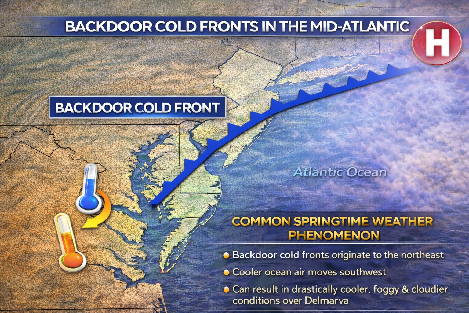
A backdoor cold front is a type of cold front that moves in from the northeast rather than from the west or northwest, which is the typical direction for most cold fronts in the United States.
Instead of sweeping across the region from the interior of the country, these fronts originate over New England or the North Atlantic and slide southwestward down the coastline. As the front moves through the Mid Atlantic, cooler air from the ocean and coastal regions pushes inland, replacing warmer air that had previously moved northward.
This process often results in rapid temperature drops, especially near the coast. It is not uncommon for areas along the Delmarva coast to see temperatures fall 10 to 20 degrees within a few hours after a backdoor front moves through.
Why Backdoor Fronts Are Common in the Spring

Backdoor cold fronts become especially common during the spring months across the Mid Atlantic because of the strong temperature contrast between land and water.
During spring, the land across the Mid Atlantic warms quickly as the sun angle increases. However, the Atlantic Ocean and nearby bays remain much colder after the winter months. This temperature difference creates the perfect setup for cooler marine air to surge inland.
At the same time, strong high pressure systems often build over eastern Canada or New England during the spring. These high pressure systems drive cooler air southwestward along the coastline, pushing the front toward areas such as New Jersey, Delaware, Maryland, and Virginia.
Because the cooler air mass travels over cold ocean water, it is typically moist and stable, which often leads to low clouds, fog, and occasionally drizzle behind the front.
A Major Forecast Challenge for Delmarva
Backdoor cold fronts are particularly challenging to forecast for the Delmarva Peninsula because of the region’s geography. Surrounded by the Atlantic Ocean, Delaware Bay, and Chesapeake Bay, the peninsula sits in a location where marine air can easily influence temperatures.
One of the biggest forecasting difficulties is determining how far inland the cooler air will push. Sometimes the front stalls near the coast, leaving inland communities much warmer. Other times it surges rapidly across the peninsula, causing temperatures to fall dramatically.
For example, on some spring days it may be near 70 degrees in western Maryland while coastal Delaware remains stuck in the 40s or 50s under cloudy skies and northeast winds.
Another challenge is that these fronts often stall and move back and forth across the region. Small shifts in wind direction or pressure patterns can cause the boundary to drift north or south, which can quickly change temperatures, cloud cover, and precipitation chances.
The Role of the Ocean and Sea Breezes
The cold Atlantic waters also enhance the effects of backdoor fronts across Delmarva. Even after the front passes, persistent onshore winds and sea breezes can keep coastal communities significantly cooler than inland areas.
This marine influence is why coastal locations such as Rehoboth Beach, Ocean City, and Cape Henlopen often experience cooler temperatures and fog while inland areas like Georgetown, Salisbury, or Dover remain warmer.
A Defining Feature of Mid Atlantic Spring Weather
Backdoor cold fronts are one of the defining characteristics of spring weather across the Mid Atlantic. Their ability to dramatically change temperatures over short distances makes them a constant challenge for meteorologists and a frequent source of forecast uncertainty.
For residents across Delmarva, these fronts are the reason why spring forecasts can shift quickly from warm and sunny to cool, cloudy, and foggy within just a few hours.


