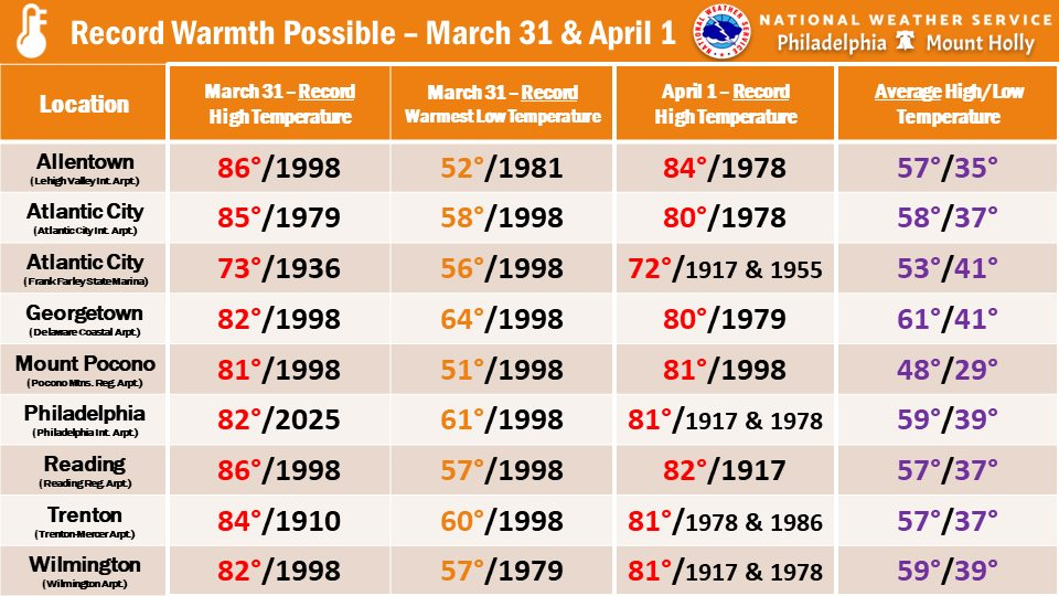

Unseasonably warm air has surged into the Delmarva region, bringing temperatures close to record levels today and continuing into Wednesday. A strengthening southwest flow, fueled by high pressure positioned offshore, is allowing much warmer air to overspread the region, pushing afternoon highs to near or even above 80 degrees in many inland areas. Coastal locations remain slightly cooler, but still well above seasonal averages for late March.

This level of warmth puts several locations within striking distance of daily record highs. After a few early clouds and spotty showers this morning, partial sunshine will help temperatures climb quickly through the afternoon. While a few isolated showers or thunderstorms may attempt to move in from the west later today, most activity is expected to weaken before reaching much of Delmarva, keeping the overall severe weather threat low.

The mild pattern continues overnight, with temperatures holding in the 60s across much of the region, more typical of late spring than early April. This sets the stage for another very warm day on Wednesday, where some parts of southern Delmarva could end up even warmer than today. However, a cold front approaching from the northwest will begin to complicate the forecast, especially farther north where slightly cooler air may start to edge in.

By Wednesday afternoon and evening, that cold front will move into the region, bringing an increasing chance for showers and a few thunderstorms. While instability will be somewhat limited, a marginal risk for isolated strong storms exists, mainly across western areas. Any storms that do develop could produce gusty winds, but widespread severe weather is not expected.
This brief surge of near-record warmth will come to an end behind the front, with cooler and more seasonable conditions expected to return heading into the latter part of the week.