Beginning today, March 3, 2026, the Storm Prediction Center is implementing significant changes to how severe weather risks are communicated in its daily convective outlooks.
The update does not change the familiar five tier categorical system used to describe overall severe weather risk. Instead, it enhances the outlooks by adding clearer information about the potential intensity of tornadoes, damaging winds, and hail, even in situations where storms may be limited in coverage.
The change is designed to improve how forecasters communicate high impact threats and help emergency managers, broadcasters, and the public better understand the severity of possible outcomes.
What Remains the Same

The SPC will continue to issue its well known categorical risk levels: Marginal Level 1, Slight Level 2, Enhanced Level 3, Moderate Level 4, and High Level 5.
These categories still represent the overall probability and expected coverage of severe thunderstorms within 25 miles of a point.
What Is New: Conditional Intensity Groups

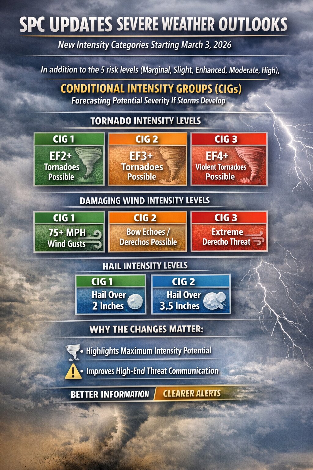
The major addition is the introduction of Conditional Intensity Groups, also known as CIGs. These new markers appear within the probabilistic tornado, wind, and hail outlooks and are intended to show the maximum expected intensity of severe hazards if storms develop.
In previous outlooks, hatched areas indicated potential for significant severe weather but did not clearly differentiate between moderate and extreme scenarios. Now, distinct intensity tiers provide clearer hazard messaging.
Tornado Outlook Changes

Tornado forecasts now include three Conditional Intensity Groups.
CIG 1 indicates an environment supportive of tornadoes up to at least EF2 strength.
CIG 2 signals potential for strong tornadoes of at least EF3 intensity.
CIG 3 highlights an environment capable of producing violent tornadoes rated EF4 or stronger.
This is particularly important in conditional setups where storm coverage may be limited but atmospheric parameters strongly favor intense tornadoes. Under the old system, that nuance was more difficult to convey visually. Now, even on days with lower overall probabilities, SPC can communicate when the ceiling for tornado strength is especially high.
Damaging Wind Outlook Changes

Wind outlooks are also receiving expanded intensity detail.
Three wind intensity tiers are now included.
CIG 1 represents potential for gusts of at least 74 miles per hour.
CIG 2 indicates an environment supportive of organized bow echoes or derechos.
CIG 3 highlights an ongoing or highly likely derecho level event.
In addition, SPC is adding higher probability thresholds of 75 percent and 90 percent to Day 1 and Day 2 wind outlooks. These elevated percentages signal very high confidence in widespread damaging wind. This refinement allows forecasters to distinguish between scattered severe gusts and large scale, high impact wind events.
Hail Outlook Changes
Hail forecasts now include two distinct intensity tiers.
CIG 1 indicates potential for hail greater than 2 inches in diameter.
CIG 2 indicates potential for hail exceeding 3.5 inches in diameter.
The addition helps differentiate between typical severe hail events and environments supportive of extremely large, destructive hail often associated with long lived supercells.
Unlike tornado and wind outlooks, hail currently includes two tiers rather than three, reflecting the rarity and forecasting challenges associated with the most extreme hail sizes.
Why the Change Matters

The update enhances SPC’s ability to communicate risk in two critical ways. It separates coverage probability from maximum intensity potential. It also better highlights high end threats in conditional environments.
For emergency planners and broadcast meteorologists, this provides clearer decision support information. For the public, it offers a more precise understanding of how dangerous storms could become, not just how likely they are to occur.
The revised outlook format takes effect with today’s convective outlook issuance and will apply to Day 1, Day 2, and Day 3 severe weather forecasts.