
A rapidly strengthening storm system is expected to bring the potential for strong to severe thunderstorms across portions of the Mid-Atlantic on Monday, including parts of Maryland, Delaware, and Virginia.
We are closely watching the evolving setup, which could lead to a volatile day of severe weather across the eastern United States, particularly from the Carolinas northward into the Mid-Atlantic.

The storm system will begin organizing this weekend as low pressure develops on the eastern side of the Rocky Mountains. As the system strengthens and lifts northeast toward the Great Lakes, the upper-level trough associated with it is expected to turn negatively tilted, a configuration that often signals a strengthening storm system.
By Monday morning, a warm front is forecast to lift north through the Mid-Atlantic, placing much of the region into the warm sector of the storm. This will allow warmer temperatures and increasing humidity to spread northward, with dew points rising into the 60s as southerly winds transport a deep plume of moisture into the region.

At the same time, the atmosphere will become increasingly dynamic. Forecast guidance shows strong height falls aloft and a powerful upper-level jet stream positioned over the Mid-Atlantic. These ingredients will help promote rising motion in the atmosphere and the development of thunderstorms.
While atmospheric instability may be somewhat limited due to cloud cover and early-day showers, the strength of the wind fields and large-scale dynamics could compensate for that limitation. Strong low-level wind shear ahead of the approaching cold front may allow thunderstorms to organize quickly Monday afternoon and evening.
The primary threat with these storms will be strong to damaging wind gusts, though a few tornadoes cannot be ruled out, especially if individual storms are able to form ahead of the main line of convection.
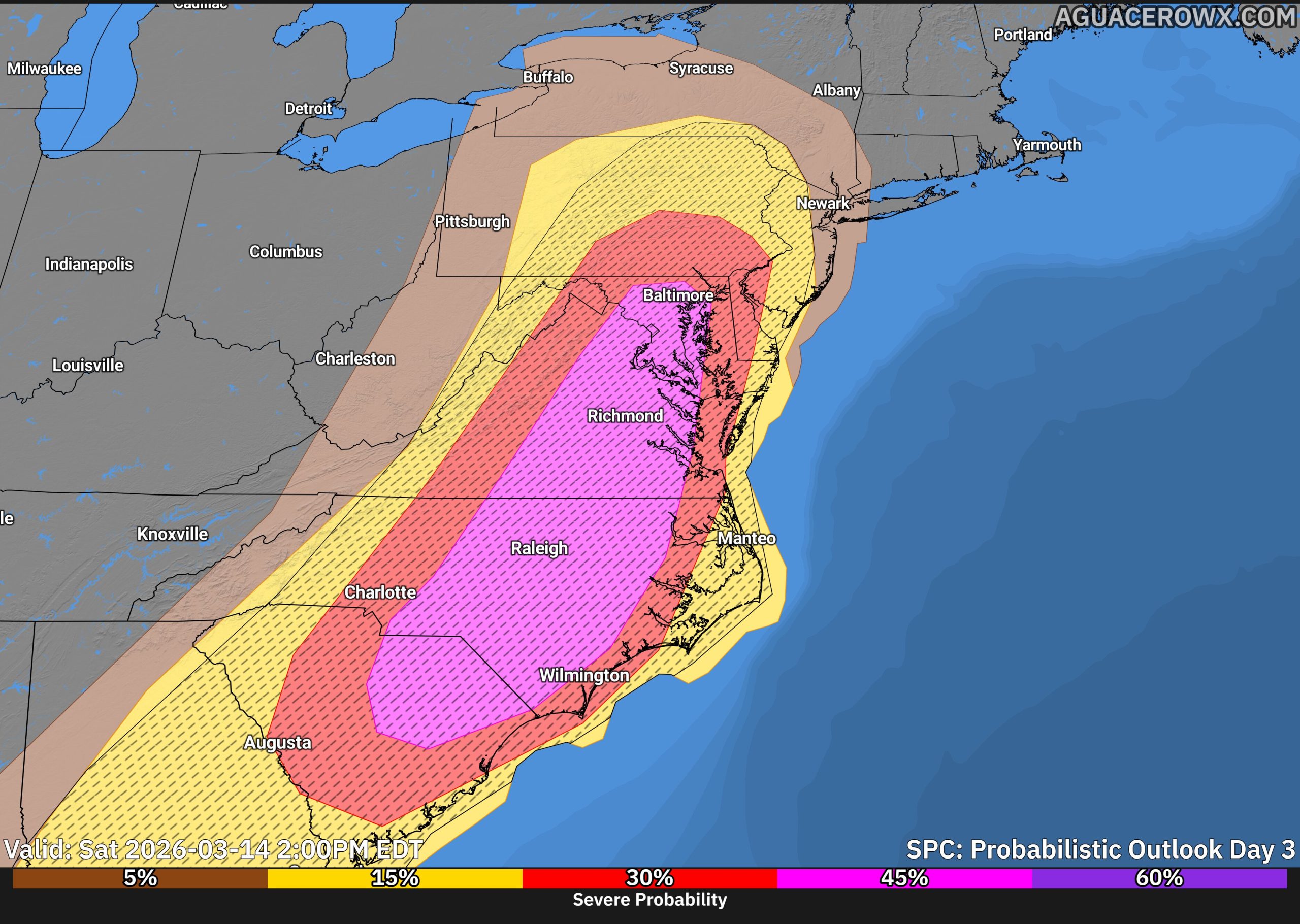
Scattered to widespread severe storms are possible across the Southeast and Mid-Atlantic on Monday. The corridor with the greatest potential for more significant severe weather currently appears to extend from South Carolina northward into Maryland, placing parts of the Mid-Atlantic near the northern edge of the higher-risk zone.
SPC Forecasters also note that this could become a very volatile severe weather day, and portions of the region from South Carolina to Maryland may even warrant an upgrade to a Level 4 Moderate Risk in later outlooks if confidence increases in the severe storm setup.
Storm modes could include a mix of discrete supercells ahead of the front as well as a fast-moving squall line. Embedded circulations within the line could enhance the tornado threat as storms move east toward the coastal plain.

In addition to the severe weather threat, the system will also bring the potential for periods of heavy rainfall. Precipitable water values are forecast to climb between 1.1 and 1.4 inches, which is above the 90th percentile for early March. While widespread flooding is not currently expected, locally heavy rain could lead to quick rises on small streams and rivers.
We will continue to refine the forecast in the coming days as the timing of the cold front and the amount of daytime heating become clearer. These factors will play a key role in determining how intense the storms become.
Residents across the Mid-Atlantic should stay weather aware on Monday and be prepared for the possibility of rapidly changing weather conditions during the afternoon and evening hours.