
A significant shift in the overall weather pattern is setting the stage for a prolonged warm up across the Delmarva Peninsula beginning mid week and continuing into early next week. An upper level trough developing over the western United States will allow strong ridging to build over the eastern half of the country. As that western trough digs farther south into western Mexico by Friday, the ridge over the East will amplify. At the surface, a large Bermuda high will take control, promoting a milder southwest flow into the Mid Atlantic and pushing temperatures well above average for early March.

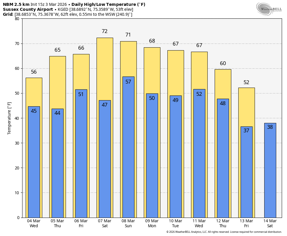
By Wednesday, highs across Delmarva will climb into the 50s to near 60 degrees. The forecast becomes more complicated from Thursday through Saturday as a frontal boundary wavers north and south across the region. The front is expected to lift north on Thursday before stalling and then dropping back south as a backdoor front Friday into Saturday. Its exact placement will create sharp temperature differences across relatively short distances. South of the boundary, temperatures will warm into the mid 60s to around 70 degrees, while areas near the front hover around 60. North of the boundary, highs may struggle in the 40s and 50s. There is increasing potential that some parts of Delmarva could trend cooler than currently forecast, particularly if a persistent east to northeast wind develops and pulls in cooler marine air from the Atlantic.
By Sunday and into early next week, the front is expected to lift back north, placing the region firmly in the warm sector once again. Highs should reach the 60s and lower 70s inland. Coastal communities, including areas along the Delaware Beaches and the Maryland and Virginia Eastern Shore, are likely to remain cooler in the 40s and 50s due to the influence of the cold ocean waters.

Although this pattern does not favor any significant storms, it will not be completely dry. The wavering boundary will serve as a focus for several weak disturbances moving through from Wednesday into Saturday, bringing multiple opportunities for showers. A slightly stronger wave Thursday night could even produce a few rumbles of thunder. Shower chances may linger into the weekend and early next week as the jet stream remains displaced well to the north.
Any rainfall that develops will be welcomed across Delmarva, where ongoing drought conditions have left soils dry. While this does not appear to be a soaking event, periodic showers could provide some short term relief as the region transitions toward spring.