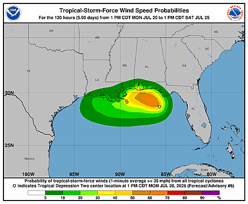

A tropical depression churning in the Gulf of Mexico is showing limited organization on satellite imagery Monday morning, with only scattered pockets of deep thunderstorm activity surrounding its circulation center. However, an Air Force Reserve reconnaissance aircraft flying through the system found that pressure continues to slowly drop, with a peak flight-level wind reading of 38 knots at 925 millibars — data that prompted forecasters to nudge the storm’s maximum winds up slightly to 30 knots in the latest advisory.
Tracking data shows the depression drifting slowly toward the northwest at about 3 knots. The system is currently caught between two mid-level high-pressure ridges — one positioned over the Rocky Mountains to its northwest and another near the Bahamas to its southeast. Forecasters expect the Rocky Mountain ridge to take over as the primary steering influence as a large weather trough moves into the northeastern United States later this week. That shift is expected to push the storm on a more west-northwest and then westward path, bringing it near or along the Gulf Coast and approaching the mouth of the Mississippi River within 72 hours. This week’s forecast track has shifted slightly northward compared to previous guidance, and the National Hurricane Center adjusted its projected path accordingly, blending two forecast models — the TVCN consensus tool and the Google DeepMind guidance system.
Forecasters say the storm’s wide, disorganized structure and dry air at mid-levels are keeping thunderstorm activity in check, resulting in only gradual strengthening. The depression is expected to reach tropical storm status later today and continue to slowly gain strength while wind shear stays low to moderate. After about 36 hours, increasing northeasterly wind shear is expected to put a stop to further intensification. With the northward track shift, land interaction becomes a more significant factor beyond 60 hours, and the latest National Hurricane Center forecast now shows the system gradually weakening after that point. Notably, the latest Google DeepMind ensemble forecast only extends the storm’s track to 72 hours, suggesting most of its computer model runs expect the system to fall apart beyond that timeframe. The intensity forecast has been lowered slightly after 72 hours compared to the previous cycle, though additional adjustments may be necessary if more guidance points to the storm moving further inland.
Key Messages from the National Hurricane Center:
Tropical storm conditions could affect parts of the Florida Panhandle and the Alabama coast beginning tonight into Tuesday. A Tropical Storm Watch is currently in effect for those areas.
Residents in Mississippi, Louisiana, and Texas should keep a close eye on this storm’s progress, as additional watches may be issued for parts of those states within the next day or two.
Flash flooding will be a threat through Friday along the Gulf Coast and nearby inland areas, stretching from western Florida all the way to the Middle Texas Coast — including southern portions of Alabama, Mississippi, and Louisiana.
This forecast was issued by Forecaster Papin at the National Hurricane Center.