The National Weather Service office out of Mount Holly, New Jersey issued a Severe Thunderstorm Warning on the evening of July 5, taking effect at 7:26PM EDT and remaining in place until 7:45PM EDT.
Residents in the areas covered by the warning were advised to seek shelter immediately and remain indoors until the warning expired. Severe thunderstorms can bring dangerous lightning, damaging winds, and heavy rainfall.
The warning was set to expire at 7:45PM EDT. Residents were encouraged to monitor local forecasts and alerts for any updates or additional warnings as conditions developed.
The National Weather Service office in Mount Holly, New Jersey issued a Severe Thunderstorm Warning on the evening of July 5, beginning at 7:04 PM EDT and set to expire at 7:45 PM EDT.
The warning was issued as an official weather alert, though no additional descriptive details — such as storm location, expected wind speeds, or hail size — were included in the available alert text.
Residents in any area covered by this warning were advised to move indoors, stay away from windows, and avoid travel until the warning expired. Severe thunderstorms can bring dangerous lightning, damaging winds, and heavy rainfall in a short period of time.
For the latest weather information and to determine if your area was included in the warning zone, residents are encouraged to check the National Weather Service website or a trusted local weather source.
The National Weather Service office out of Mount Holly, New Jersey issued a Severe Thunderstorm Warning on the evening of July 5, beginning at 6:54 PM EDT and running through 7:45 PM EDT.
The warning was issued as a public safety alert for those in the affected region. Residents were advised to seek shelter, stay away from windows, and remain indoors until the warning expired.
Severe thunderstorm warnings are typically issued when weather conditions are capable of producing damaging winds, large hail, or other hazardous conditions. Anyone caught outdoors during such a warning should move inside immediately and avoid contact with metal objects or standing water.
Residents are encouraged to monitor local weather updates and have a plan in place in the event of rapidly changing storm conditions.
The National Weather Service out of Mount Holly, New Jersey has put a Severe Thunderstorm Watch into effect beginning at 6:48 PM EDT on July 5, lasting through 1:00 AM EDT on July 6.
A Severe Thunderstorm Watch means conditions are favorable for severe thunderstorms to develop in and around the watch area. Residents are urged to remain alert and be ready to act quickly if a Severe Thunderstorm Warning is issued for their location.
Severe thunderstorms can bring damaging winds, large hail, and heavy rainfall. People are encouraged to stay indoors, avoid open areas, and keep an eye on local weather updates throughout the evening and into the early morning hours.
New Bridge Road is currently closed between DE-141 and Creek Road following a downed tree blocking the roadway.
Motorists traveling through the area are advised to find alternate routes until the road is reopened. No estimated time for the road to reopen has been announced at this time.
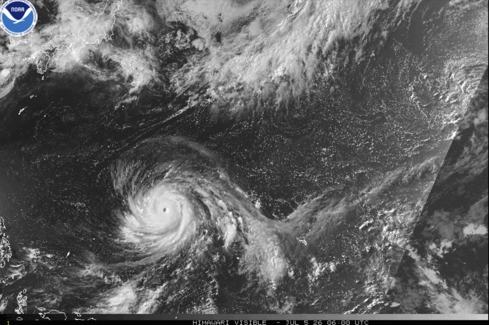
People living on Guam and nearby U.S. island territories in the western Pacific were told to seek shelter immediately as Super Typhoon Bavi closed in on the region, expected to make landfall early Monday — striking an area that is still healing from a powerful storm that hit earlier this year.
National Weather Service meteorologist Edwin Montvila said Bavi, a massive cyclone moving toward the Mariana Islands east of the Philippines, was on track to hit Rota early Monday morning local time.
“They are currently already encountering catastrophic wind,” Montvila said of Rota, a small territory of fewer than 2,000 residents located northeast of Guam. He added that an extreme wind warning was in place for the island. The storm is forecast to reach category five super typhoon strength, with sustained winds potentially hitting 180 miles (290 kilometers) per hour and gusts up to 215 miles (346 kilometers) per hour.
Beyond Rota, typhoon warnings were also issued for Guam, Tinian, and Saipan, while tropical storm warnings and watches covered other nearby islands.
This storm follows Super Typhoon Sinlaku — the strongest tropical cyclone of the year — which hammered the same island chain back in April with ferocious winds and relentless rainfall. For reference, a cyclone earns super typhoon status when its maximum sustained winds reach at least 150 mph (241 kph).
Montvila described Bavi as posing an “imminent danger to life,” with weather officials directing residents to move immediately to interior rooms in their shelters and stay clear of windows.
“Entering outside can result in death from flying projectiles. Utility poles and associated power lines will be down,” Montvila warned. “All those would pose a risk to life, so we recommend people to not venture out and hunker down.”
The storm was moving at a relatively quick pace Monday morning, giving officials some hope it would pass through without lingering. However, Montvila cautioned that due to the sheer size of Bavi, islands in the area could still be dealing with tropical storm conditions — including heavy rainfall — well into Monday night.
He also noted the typhoon “was a bit erratic” overnight into Monday morning, drifting north and south as it tracked westward toward the islands.
Guam Gov. Lou Leon Guerrero called on residents to remain at home or in a shelter and to stay off the roads.
“Here we are experiencing another severe force of winds on our island, but as we know, we are always ready and prepared in our planning and our protection of our people,” she said in a video she shared on social media Sunday.
The National Weather Service out of Mount Holly, New Jersey issued a Severe Thunderstorm Warning on the evening of July 5, taking effect at 5:08 PM Eastern Time.
The warning was set to expire at 6:00 PM Eastern Time on July 5. Residents in areas covered by the alert were advised to move indoors and stay away from windows until the warning had passed.
Severe thunderstorms can bring dangerous lightning, damaging winds, and large hail. Authorities recommend avoiding travel during active warnings and waiting for the all-clear before heading back outside.
The National Weather Service office in Mount Holly, New Jersey issued a Severe Thunderstorm Warning on the evening of July 5, taking effect at 5:43 PM Eastern Time.
The warning was scheduled to expire at 6:00 PM Eastern Time on July 5, giving residents a short but critical window to take precautions and seek shelter from potentially dangerous storm conditions.
Residents in the warned area were advised to stay indoors, away from windows, and to avoid travel until the warning had expired and conditions improved.
The National Weather Service office in Mount Holly, New Jersey issued a Severe Thunderstorm Warning on July 5, taking effect at 5:26 PM EDT and running through 6:00 PM EDT.
Residents in the areas covered by the warning were advised to seek shelter and stay indoors until the warning expired. Severe thunderstorms can bring dangerous lightning, damaging winds, and heavy rainfall.
The warning was set to expire at 6:00 PM EDT. Residents were encouraged to monitor local forecasts and official NWS updates for the latest information as conditions developed.
Firefighters battling a major wildfire in southern Colorado could soon face an even tougher fight, as threatening weather conditions are expected to move into the area.
Thunderstorms carrying strong, gusty winds are forecast to roll through the region, a combination that could make it significantly harder for crews to contain the massive blaze that has already torn through parts of the southern part of the state.
The fire, known as the Aspen Acres Fire, was photographed actively burning on Friday near the community of Rye, Colorado, as crews continued their efforts to establish containment lines around the blaze.
Weather conditions including high winds are among the most dangerous factors firefighters can face, as they can rapidly shift the direction of a fire and cause it to spread faster than crews can respond.
The National Weather Service office in Mount Holly, New Jersey has put a Flood Watch in place starting Saturday, July 5 at 3:15 PM Eastern Time, with the watch remaining active through Sunday, July 6 at 8:00 PM Eastern Time.
A Flood Watch means that conditions are favorable for flooding to develop in the watch area. Residents should take precautions, avoid low-lying areas near waterways, and be ready to act quickly if flooding begins.
Officials urge people to never attempt to drive through flooded roadways and to stay informed by monitoring the latest updates from the National Weather Service.
Northbound travelers on Route 1 between Hall Avenue and Lewes are facing slowdowns due to heavy congestion, according to traffic officials.
The backup is adding approximately 10 to 15 minutes to travel times along that corridor. Drivers in the area are encouraged to allow extra time or seek alternate routes to avoid the delay.
Northbound travelers on Delaware Route 1 should expect a significant slowdown between exits 114 and 119, where congestion is adding 20 to 25 minutes to drive times.
The delay is due to heavy traffic buildup in that corridor. No additional details about the cause of the congestion were provided.
Drivers are encouraged to allow extra time or seek alternate routes until conditions improve.
A dangerous heat dome that baked parts of the central and eastern United States is now being blamed for at least 19 deaths in New Jersey, even as powerful storms swept in behind it, cutting power to nearly one million homes and businesses across the region.
New Jersey health officials said Saturday that heat-related fatalities began appearing as early as Thursday, with the majority concentrated in the central and northern portions of the state.
State Health Commissioner Dr. Raynard Washington addressed reporters Saturday, saying, “Unfortunately, many of these individuals were found in homes without air conditioning. A few were outside their residences, some on the street and some even in parked cars.”
New Jersey Gov. Mikie Sherrill described the event as “the hottest stretch we’ve seen in over 14 years,” and stressed that the danger extended beyond the elderly or those with existing medical conditions. “The heat’s hitting all of us, not just seniors, not just with underlying health conditions, people of all ages,” Sherrill said.
The scorching temperatures shattered records across the area. On Thursday, LaGuardia Airport in New York reached a new high of 104 degrees Fahrenheit (40 degrees Celsius), surpassing the previous record of 101 F (38.3 C) that had stood since 1966, according to Bryan Jackson, a meteorologist with the National Oceanic and Atmospheric Administration’s Weather Prediction Center. Trenton, New Jersey, hit 101 F, breaking a record of 100 F (37.7 C) that dated back to 1901. Newark climbed even higher, reaching 105 F (40.5 C) on Thursday.
Atlantic City also smashed records, reaching 103 F (39.4 C) on Thursday — topping its previous record of 100 F set in 1966 — then climbing to 105 F on Friday and 106 F (41.1 C) on Saturday, Jackson confirmed.
Jackson explained why heat domes are so dangerous, combining extreme temperatures with high humidity. “In a lot of cases they also had direct sunshine,” he said. “It was relentless. It was multiple days. It was not as cool overnight, as well. The low Friday morning in Atlantic City was 80. The body can’t recover as well. You just have that multiple day buildup and too much added stress on the body.”
As the heat gradually pushed eastward, severe thunderstorms moved in with powerful winds that toppled utility poles and brought trees crashing down onto power lines. By early Sunday afternoon, roughly 900,000 utility customers across parts of the central, eastern, and southern United States were without electricity, according to PowerOutage.com.
Michigan saw more than 223,000 customers lose power, while close to 170,000 customers in Pennsylvania were also affected. PPL Electric reported 121,417 customers without power Sunday morning, including approximately 47,000 in the Harrisburg, Pennsylvania, area. In New York State, Central Hudson reported more than 430 downed wires on Sunday, with about 50,000 customers impacted, though roughly 650 were still without service by Sunday.
In the Detroit area, Amanda Vesper, 40, of Commerce Township, was putting her children to bed Friday evening when the first round of storms hit and cut her power. “It didn’t seem that awful. It got quite windy,” she recalled. By late Sunday morning, her electricity had still not been restored.
“We’ve been going back and forth between a hotel and our home because we have dogs there,” Vesper said. “We really can’t stay there. I have a small child with autism. Our well runs on an electric pump.” The ongoing outage also forced the family to cancel their Fourth of July plans. “We had planned on having company over at the house, but had to cancel,” she said. “I went grocery shopping. I’m hoping my freezer holds.”
Jackson warned that heavy thunderstorms are expected Sunday in and around the Cleveland area before shifting east into Pennsylvania, New Jersey, and New York, where the risk of flash flooding remains a concern.
The National Weather Service out of Mount Holly, New Jersey has put a Flood Watch into effect starting Saturday, July 5 at 12:09 PM Eastern Time, with the watch continuing through Sunday, July 6 at 8:00 PM Eastern Time.
A Flood Watch means that conditions are favorable for flooding to develop in the affected area. Residents are encouraged to monitor local forecasts closely and be ready to take action if flooding begins or a more urgent Flood Warning is issued.
If you live in a low-lying area or near streams and waterways, now is the time to make preparations. Avoid unnecessary travel through areas prone to standing water, and never attempt to drive through flooded roadways.
TV Delmarva will continue to monitor this situation and provide updates as new information becomes available from the National Weather Service.
The National Weather Service office in Mount Holly, New Jersey has issued a Heat Advisory that took effect Saturday, July 5 at 12:08 PM EDT and remains in place until 8:00 PM EDT that same evening.
Residents are encouraged to stay hydrated, seek air-conditioned spaces, and check on elderly neighbors and relatives during the period of elevated heat. Young children and pets should never be left in parked vehicles.
The advisory was issued as heat conditions reached levels considered potentially hazardous to public health. Those who must be outdoors are advised to limit strenuous activity and take frequent breaks in the shade or indoors.
Westbound travelers on Lighthouse Road (Delaware Route 54) between Coastal Highway (Delaware Route 1) and Mallard Lakes should expect delays of 15 to 20 minutes due to heavy congestion in the area.
Drivers are encouraged to allow extra travel time or consider using an alternate route until conditions improve.
Northbound travelers on Coastal Highway, also known as Delaware Route 1, are encountering delays in the Dewey Beach area.
According to traffic reports, congestion between Dewey Beach State Park and Wolfe Neck Road is causing a 5 to 10 minute delay for drivers heading north.
Motorists in the area should expect slower than normal travel times and may want to consider alternate routes if possible.
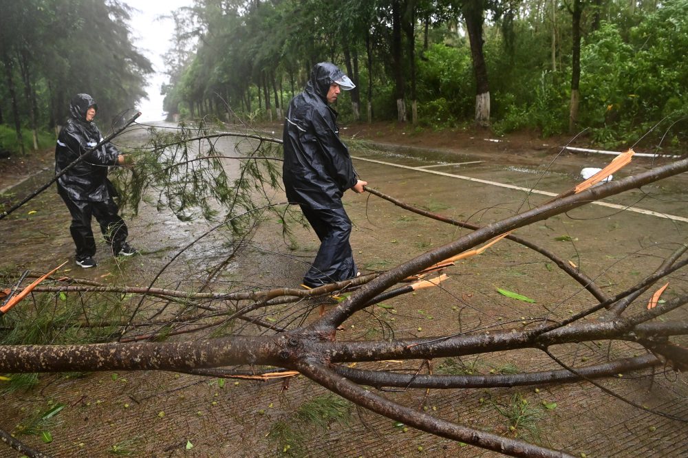
State media in China reported Sunday that heavy rainfall has resulted in five deaths in the country’s north, while a tropical storm caused significant destruction across southern China and neighboring Vietnam.
According to the official Xinhua News Agency, two villagers lost their lives Saturday evening when a flash flood struck a mountainous area in the eastern portion of China’s Inner Mongolia region. One person drowned while tending to cattle, and another fell into floodwaters while attempting to move a herd to safety.
That same day, three additional fatalities were recorded roughly 390 kilometers — about 240 miles — to the southeast in Fushun, a city in Liaoning province. Xinhua did not release details on the circumstances of those deaths.
Fushun was hammered by a powerful rainstorm for several hours early Saturday, with rainfall reaching as much as 32.9 centimeters — approximately 13 inches — in at least one location. Video circulating online showed city streets completely submerged. Authorities relocated around 3,600 residents to safer ground.
Meanwhile, in China’s south, Tropical Storm Maysak crossed into the Guangxi region on Sunday after coming ashore the night before in Vietnam’s Quang Ninh province, packing winds of 101 kilometers — or 63 miles — per hour. As the storm pushed inland, it weakened from severe tropical storm status down to a standard tropical storm.
Footage aired on China’s state broadcaster CCTV showed rivers overflowing their banks in Guangxi’s Fangchenggang city, with cars submerged up to their rooftops. Emergency crews deployed inflatable boats to reach people who were stranded. A China News Service report noted that local residents described the flooding as the worst they had seen in roughly 20 years.
In Vietnam, the storm caused considerable damage Saturday evening in the town of Mong Cai, knocking down trees and tearing metal roofing off buildings, according to Vietnamese state media. After the winds died down, crews brought in chainsaws and heavy equipment to clear debris and restore access to roads.
Maysak also uprooted trees in Dongxing, a Chinese city that sits along the Vietnamese border. The storm had previously dumped heavy rain on China’s Hainan island before crossing open water and making landfall again in Vietnam.
A portion of Blackbird Landing Road is closed at this time following a downed tree and downed wires in the area.
The closure is in effect from Union Church Road to Gum Bush Road. Motorists are advised to avoid the area and plan for alternate routes until crews are able to clear the obstruction and make the roadway safe.
No timeline for reopening has been announced at this time. Drivers should use caution in the surrounding area and watch for emergency personnel on scene.
The National Weather Service office in Mount Holly, New Jersey has issued a Heat Advisory effective Saturday, July 5, beginning at 2:45 AM Eastern Time and lasting through 8:00 PM that same evening.
Residents in the affected areas should be aware of the potential health risks associated with extreme heat. Officials typically recommend staying hydrated, limiting outdoor activity during peak afternoon hours, and checking on elderly neighbors and those without air conditioning during heat advisory periods.
The advisory was issued in the early morning hours of July 5, giving residents advance notice to prepare for the day’s dangerous heat conditions.
The National Weather Service out of Mount Holly, New Jersey has put a Flood Watch into effect as of 2:33 AM EDT on Saturday, July 5, with the alert lasting through 8:00 PM EDT on Sunday, July 6.
A Flood Watch means that conditions are favorable for flooding to develop in the affected area. Residents are urged to stay alert and monitor local forecasts closely as the situation evolves.
If flooding does occur, people should avoid walking or driving through floodwaters, as even shallow moving water can be dangerous. Just six inches of fast-moving water can knock a person off their feet, and a foot of water can sweep a vehicle away.
Stay tuned to TV Delmarva for the latest updates on this developing weather situation.
A Heat Advisory has been issued by the National Weather Service out of Mount Holly, New Jersey, beginning late Friday, July 4th at 10:52 PM Eastern Time and lasting through Saturday, July 5th at 8:00 PM Eastern Time.
Residents are encouraged to take the necessary steps to stay safe during this period of elevated heat. Health officials typically recommend drinking plenty of water, avoiding prolonged exposure to direct sunlight, and checking on elderly neighbors and family members during heat events.
The advisory was issued as dangerously warm conditions are anticipated to impact the region through Saturday evening. Those who must be outdoors should try to limit activity during the hottest parts of the day and seek air-conditioned spaces when possible.
Drivers traveling on Route 495 should be aware that the posted speed limit has been reduced to 55 miles per hour in response to ongoing weather conditions.
The Delaware Department of Transportation issued the advisory, lowering the normal speed limit along the corridor to help ensure driver safety during the hazardous conditions.
Motorists are encouraged to slow down, increase following distance, and remain alert while traveling the affected stretch of roadway. The speed restriction will remain in place until conditions are deemed safe enough to restore normal limits.
The National Weather Service out of Mount Holly, New Jersey issued a Severe Thunderstorm Warning on the night of July 4th, putting area residents on alert during the holiday evening.
The warning went into effect at 9:52 PM Eastern Time and was set to expire at 10:30 PM Eastern Time on July 4th.
Residents in the affected area were advised to seek shelter indoors and stay away from windows during the warning period. Severe thunderstorms can bring dangerous lightning, strong winds, and heavy rainfall.
TV Delmarva will continue to monitor any developing weather situations and provide updates as conditions change.
The National Weather Service office in Mount Holly, New Jersey put out a Severe Thunderstorm Warning on the evening of July 4th, beginning at 9:10 PM Eastern Time and running through 9:45 PM EDT.
Those in the warned area were advised to seek shelter immediately and remain indoors until the warning expired. Severe thunderstorm warnings are typically issued when weather conditions pose a significant threat, including damaging winds or large hail.
Residents are encouraged to monitor their local weather and follow any additional guidance from the National Weather Service as conditions develop.
The National Weather Service out of Mount Holly, New Jersey issued a Severe Thunderstorm Warning on the evening of July 4th, effective from 9:07 PM EDT until 9:45 PM EDT.
The warning was put in place to alert residents in the affected region of dangerous thunderstorm conditions during the Independence Day holiday evening.
Residents were advised to seek shelter indoors, stay away from windows, and avoid outdoor activities until the warning expired at 9:45 PM.
The National Weather Service office out of Mount Holly, New Jersey issued a Severe Thunderstorm Warning on the evening of July 4th, beginning at 8:59 PM Eastern Time and set to expire at 9:45 PM Eastern Time.
Residents in the areas covered by the warning were advised to seek shelter immediately and remain indoors until the warning had passed. Severe thunderstorms can bring dangerous lightning, damaging winds, and heavy rainfall.
No additional specifics regarding the exact counties or communities included in the warning were available in the original alert. Viewers are encouraged to monitor their local National Weather Service alerts and stay weather-aware, especially during holiday outdoor gatherings.
The National Weather Service out of Mount Holly, New Jersey issued a Severe Thunderstorm Warning on the evening of July 4th, taking effect at 8:48 PM Eastern Time.
The warning remained active until 9:45 PM EDT, giving residents less than an hour’s notice to seek shelter and stay indoors during the holiday celebration.
Authorities encouraged anyone outdoors for Fourth of July festivities to move inside immediately and monitor local weather updates until the warning expired.
The National Weather Service office in Mount Holly, New Jersey issued a Severe Thunderstorm Warning on July 4th at 8:38 PM Eastern Time, with the alert set to remain in effect until 9:30 PM Eastern Time that same evening.
The warning was put out by forecasters as severe thunderstorm conditions were expected in the area covered by the alert. Residents were advised to seek shelter immediately and remain indoors until the warning expired.
Severe thunderstorm warnings are issued when weather conditions pose a significant threat, including the possibility of damaging winds and large hail. People in the affected zone were encouraged to stay away from windows and avoid unnecessary travel during the warning period.
The National Weather Service out of Mount Holly, New Jersey issued a Severe Thunderstorm Warning on the evening of July 4th, going into effect at 8:17 PM Eastern Time and expiring at 9:00 PM Eastern Time that same night.
The warning was issued as part of an official weather alert, urging anyone in the affected zone to seek shelter immediately and stay away from windows until the threat had passed.
Residents were reminded that severe thunderstorms can bring dangerous lightning, strong winds, and heavy rainfall in a short period of time. Officials always recommend having a plan in place and monitoring local weather updates closely during active warning periods.
The National Weather Service out of Mount Holly, New Jersey issued a Severe Thunderstorm Warning on the evening of July 4th, effective starting at 7:17 PM Eastern Time.
The warning was scheduled to expire at 8:00 PM Eastern Time on July 4th, giving residents less than an hour to take precautions and seek shelter from dangerous storm conditions.
Residents in areas covered by the warning were advised to move indoors, stay away from windows, and avoid outdoor activities until the warning expired or was cancelled by forecasters.
The National Weather Service out of Mount Holly, New Jersey has issued an Extreme Heat Warning for the area, running from 3:10 PM EDT through 8:00 PM EDT on July 4th.
The warning covers the holiday afternoon and evening hours — a time when many people are expected to be outdoors for Independence Day celebrations. Authorities are urging residents to limit time in the sun, drink plenty of water, and seek air-conditioned spaces whenever possible.
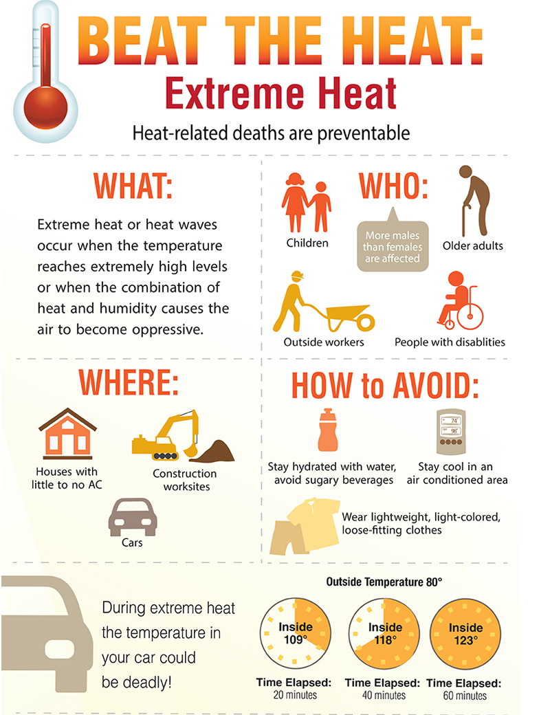
Those most at risk during extreme heat events include the elderly, young children, and individuals with certain medical conditions. Officials recommend checking on neighbors and loved ones who may not have access to air conditioning.
If you or someone you know is experiencing symptoms of heat exhaustion or heat stroke — such as heavy sweating, dizziness, confusion, or a rapid pulse — seek medical attention immediately.
The National Weather Service out of Mount Holly, New Jersey has issued a Severe Thunderstorm Watch for the area, beginning at 3:29 PM Eastern Time on July 4th and running through 11:00 PM Eastern Time the same evening.
A Severe Thunderstorm Watch means conditions are favorable for severe thunderstorms to develop across the affected area. Residents should remain alert and monitor updated forecasts as the evening progresses.
With Fourth of July celebrations and outdoor gatherings planned throughout the region, officials urge the public to keep a close eye on the sky and be ready to seek shelter quickly if threatening weather approaches. Severe thunderstorms can bring damaging winds, large hail, and heavy rainfall.
Stay tuned to TV Delmarva for the latest weather updates throughout the evening as conditions develop.
An Extreme Heat Warning is in effect for the area this Fourth of July, according to the National Weather Service office in Mount Holly, New Jersey.
The warning went into effect at 3:10 PM Eastern Time on July 4th and is set to expire at 8:00 PM Eastern Time the same evening, covering the peak heat hours of the holiday afternoon.
Residents planning to be outdoors for Independence Day festivities — including parades, cookouts, and fireworks gatherings — should be aware of the dangerous heat conditions during this time window.
Health officials generally advise staying hydrated, seeking shade or air-conditioned spaces, and checking on elderly neighbors and young children during extreme heat events. Pets should also be kept out of direct sunlight and given plenty of water.
Residents should monitor local forecasts and heed any additional guidance from emergency management officials as the holiday progresses.
Three children died after a boat capsized on Geneva Lake in Wisconsin’s Walworth County during a fierce Fourth of July storm — and authorities confirmed that all four children aboard the vessel had been wearing life jackets at the time.
The lake, located in a region of Southern Wisconsin long popular with vacationers from the Chicago area, became the site of a devastating holiday tragedy after a sudden and powerful storm swept through. The storm also toppled trees, snapped power lines, and made roads dangerous across several states.
According to a statement from Lake Geneva’s police department, a privately owned recreational motorboat with 10 people on board — including four children — attempted to reach shore quickly as conditions deteriorated. The boat was overwhelmed by powerful winds and waves, took on water, and eventually sank.
Rescuers pulled six adults and one child from the water alive. However, three children recovered during an extensive search were unresponsive, and lifesaving efforts administered immediately upon finding them were unsuccessful, police said.
In the wake of the storm, Lake Geneva Mayor Todd Krause declared a local emergency. He noted that one person sustained minor injuries after a falling tree struck them, and that downed trees and power lines blocked several streets throughout the area.
The Wisconsin Department of Natural Resources and the Geneva Lake Law Enforcement Agency launched investigations into the incident.
The deadly storm was part of a broader pattern of severe weather that swept across the Midwest and Northeast on Friday, forcing numerous cities to call off Independence Day festivals and push back fireworks shows. In Belleville, New Jersey, Mayor Frank Velez announced the celebration would be rescheduled to next year, telling residents: “While we’re disappointed we couldn’t celebrate together tonight, your safety will always come first.”
A violent storm that struck the New York area late Friday left hundreds of thousands of utility customers in the dark, halted train service to New Jersey, and damaged or uprooted thousands of trees. When combined with storm damage across the Midwest, nearly one million people were without electricity. By midday on July Fourth, roughly 750,000 utility customers remained powerless across Wisconsin, Michigan, Illinois, Pennsylvania, Ohio, New York, and New Jersey.
Despite the storms, dangerous heat returned quickly. By noon on July Fourth, temperatures in parts of the Northeast were climbing back toward triple digits. Forecasters predicted additional storms later in the day would bring relief, with significantly cooler temperatures expected heading into the new week.
Southbound travelers on Coastal Highway should expect some extra time behind the wheel as congestion is causing delays between the DE 1A Rehoboth Beach interchange and Collins Avenue.
According to traffic reports, the backup is resulting in approximately 5 to 10 minutes of additional travel time through that corridor.
Drivers in the area are encouraged to allow extra time or look for alternate routes to avoid the slowdown.
Motorists traveling eastbound on Route 54 should expect some added time behind the wheel as congestion is causing delays between Mallard Lakes and Coastal Highway.
According to traffic officials, the backup is resulting in wait times of roughly 5 to 10 minutes along that corridor.
Drivers are encouraged to plan accordingly and allow extra travel time until the congestion clears.
Travelers on Route 26 westbound should expect some added time behind the wheel as congestion is causing noticeable slowdowns in the area.
According to traffic reports, the delay is affecting the stretch of roadway running from Coastal Highway to Central Avenue, with backups adding roughly five to ten minutes to travel times.
Drivers in the area may want to allow extra time or look for alternate routes to avoid the congestion.
A powerful and historic heat wave sweeping across the United States is putting a damper on Fourth of July celebrations, pushing event organizers in communities nationwide to cancel parades and postpone other Independence Day activities.
The dangerous temperatures are making it difficult — and in some cases impossible — to safely hold outdoor events that millions of Americans look forward to each year. As a result, organizers have been left with little choice but to alter or completely call off their planned festivities.
One year has passed since devastating floods tore through parts of the Texas Hill Country, and two neighboring communities are now telling very different stories about what recovery looks like.
Though the disaster struck the same general region, the two communities have each chosen a separate course in their efforts to rebuild and move forward from the destruction left behind.
The contrast between the two towns offers a striking look at how communities can respond in fundamentally different ways when faced with the same catastrophic event.
The National Weather Service office in Mount Holly, New Jersey has issued an Extreme Heat Warning covering the July 4th holiday, beginning at 3:57 AM EDT and lasting until 8:00 PM EDT on July 4th.
An Extreme Heat Warning is the highest level of heat alert issued by the National Weather Service, indicating that dangerously hot conditions are expected that could pose a serious risk to public health.
Residents are strongly encouraged to stay indoors in air-conditioned spaces as much as possible during the warning period. If you must be outside, drink plenty of water, wear lightweight and light-colored clothing, and take frequent breaks in the shade or cool environments.
Health officials typically remind the public during extreme heat events to check on elderly neighbors, young children, and pets, as these groups are especially vulnerable to heat-related illness. Never leave children or animals in parked vehicles.
Cooling centers may be available in your area. Contact your local government or emergency management office for more information on nearby resources.
The National Weather Service office in Mount Holly, New Jersey has issued an Extreme Heat Warning effective July 4th, beginning at 3:57 AM EDT and lasting through 8:00 PM EDT that same evening.
Residents are advised to take the warning seriously, as extreme heat can pose significant health risks, particularly for vulnerable populations including the elderly, young children, and those with underlying health conditions.
Officials recommend staying indoors in air-conditioned spaces during peak heat hours, drinking plenty of water, and checking on neighbors and family members who may be at risk.
The warning remains in effect through the evening hours of the Fourth of July holiday.
Three people lost their lives and seven more were rescued Friday after a boat overturned on Geneva Lake during a powerful storm that tore through southern Wisconsin, according to a county official.
Tom Hausner, undersheriff for the Walworth County Sheriff’s Department, said the storm caused widespread damage across Walworth County — toppling trees, bringing down power lines, and damaging buildings. He added that many injuries were reported throughout the area.
Hausner said he did not have further details about those who died or the people who were rescued from the water.
Law enforcement in the city of Lake Geneva has taken over the investigation, Hausner said. Officials there did not immediately respond to requests for comment.
Lake Geneva Mayor Todd Krause declared a local emergency following the storm. In a statement, he noted that one person suffered minor injuries after being struck by a falling tree, and that several parts of the city were dealing with power outages.
Hausner said the county’s 911 center was flooded with calls from residents reporting storm damage, people trapped inside buildings, and requests for assistance. He said deputies moved quickly to respond, but were slowed down by downed power lines and trees blocking roads throughout the area.
“Power lines are all over the place. We are urging people to stay away,” Hausner said.
He said his department reached out to neighboring counties and the Wisconsin Department of Natural Resources for additional support.
Geneva Lake is a popular summer destination in southern Wisconsin, drawing visitors from the Chicago area and beyond. According to Hausner, the population of Walworth County — where the lake sits — nearly doubles on holiday weekends.
The storms, which moved through the Midwest on Friday afternoon and evening, forced multiple cities to cancel Fourth of July festivals and push back scheduled fireworks displays.
The National Weather Service issued a severe thunderstorm watch for the Lake Geneva area, forecasting heavy rain Friday with showers expected to linger into Independence Day and a continued chance of storms throughout the weekend.
The National Weather Service office in Mount Holly, New Jersey has issued an Extreme Heat Warning effective from 10:53 PM on July 3rd through 8:00 PM on the evening of July 4th.
The warning covers the region during what is typically one of the busiest outdoor holidays of the year. Residents planning to attend Fourth of July celebrations, cookouts, or fireworks events should be aware of the dangerous heat conditions expected throughout the day.
Health officials generally advise that during extreme heat events, people should drink plenty of water, wear lightweight and light-colored clothing, and limit strenuous outdoor activity — especially during the hottest parts of the afternoon. Those without air conditioning are encouraged to seek out cooling centers.
Extra attention should be given to elderly residents, young children, and pets, who are particularly vulnerable to heat-related illness. Never leave children or animals in parked vehicles.
Residents should monitor updated forecasts from the National Weather Service as the holiday approaches.
An Extreme Heat Warning has been issued by the National Weather Service out of Mount Holly, New Jersey, covering the area through much of the Fourth of July holiday.
The warning took effect late Thursday night at 10:53 PM EDT on July 3rd and is set to expire at 8:00 PM EDT on Friday, July 4th.
Residents are encouraged to stay hydrated, limit time outdoors during peak heat hours, and check on elderly neighbors, young children, and pets during the dangerous heat event. If you do not have air conditioning, consider visiting a cooling center in your area.
Officials typically remind the public that extreme heat is one of the leading weather-related causes of death in the United States. Taking simple precautions can be life-saving during conditions like these.
One year after a catastrophic flood devastated communities along the Guadalupe River in central Texas, residents of Kerrville came together to mark the grim anniversary of the disaster.
The occasion was a somber one, as those in the community paused to remember the death and destruction that the floodwaters unleashed on the region.
The Guadalupe River flooding left a lasting mark on Kerrville and surrounding communities, and Thursday’s remembrance reflected the weight of that loss still felt by those who lived through it.
A dangerous heat wave threw a wrench into Fourth of July festivities across much of the central and eastern United States on Friday, as officials scrambled to cancel or postpone dozens of parades, concerts, and fireworks shows while the nation celebrated its 250th anniversary.
Among the events disrupted was the Great American State Fair on the National Mall in Washington — a key part of President Donald Trump’s plans to commemorate the country’s 250th birthday. The fair temporarily shut its doors Friday afternoon as temperatures climbed to 101 degrees Fahrenheit (38 degrees Celsius). Organizers said they planned to reopen at 5 p.m., weather permitting, with added safety measures including cooling tents and misting stations.
Record-setting temperatures had moved into the eastern part of the country from the Midwest earlier in the week. The National Weather Service reported that more than 185 million people were under heat alerts on Friday, with heat index values potentially climbing as high as 115 degrees Fahrenheit (46 degrees Celsius) in many areas.
Forecasters and government officials warned that the extreme heat could turn deadly. They urged anyone spending time outdoors during the Fourth of July weekend to drink plenty of water, find shade when possible, and be alert to warning signs of heat-related illness.
Event cancellations were reported across at least seven states. Among the most notable was a major Independence Day parade in Philadelphia, along with events in Takoma Park, Maryland, and Loudoun County, Virginia.
The National Weather Service office in Mount Holly, New Jersey has issued a Severe Thunderstorm Watch for the area, beginning at 3:36 PM EDT on July 3rd and remaining in effect until 11:00 PM EDT that same night.
A Severe Thunderstorm Watch means conditions are favorable for the development of severe thunderstorms across the watch area. Residents should remain alert and be ready to take shelter quickly if a warning is issued.
Meteorologists urge people to stay weather-aware throughout the evening hours. Have a plan in place, keep devices charged, and monitor local forecasts for any updates or upgraded warnings as storms develop.
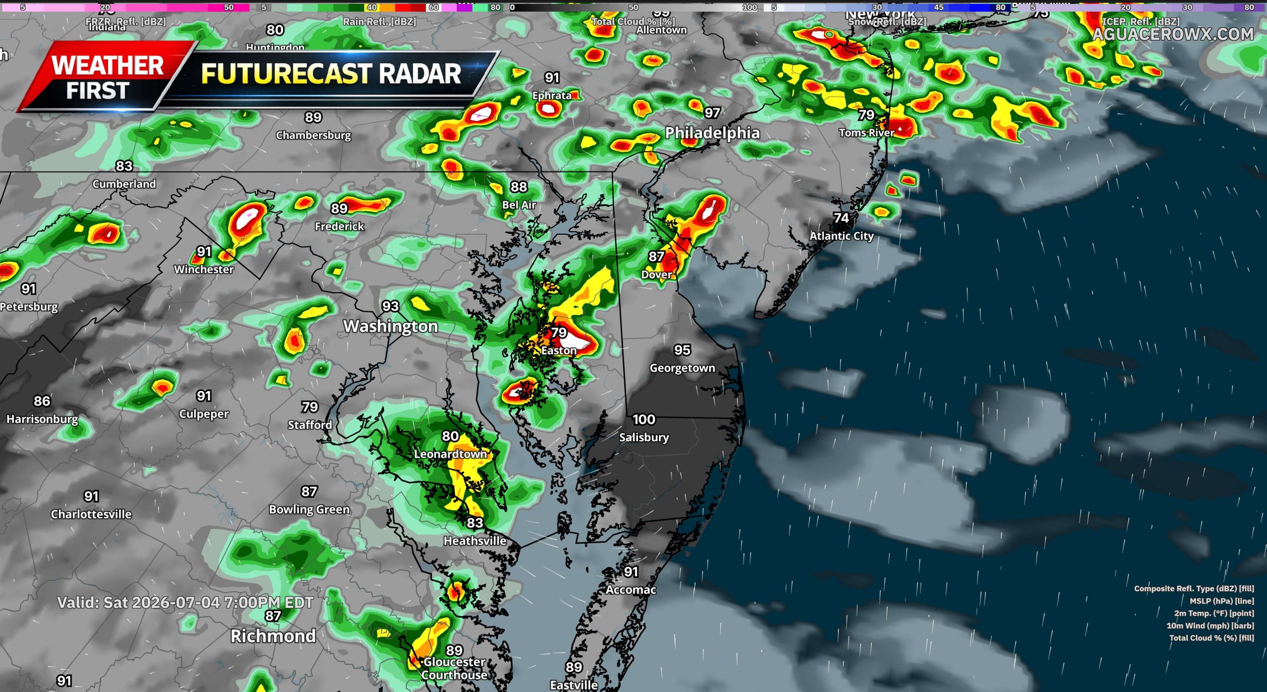
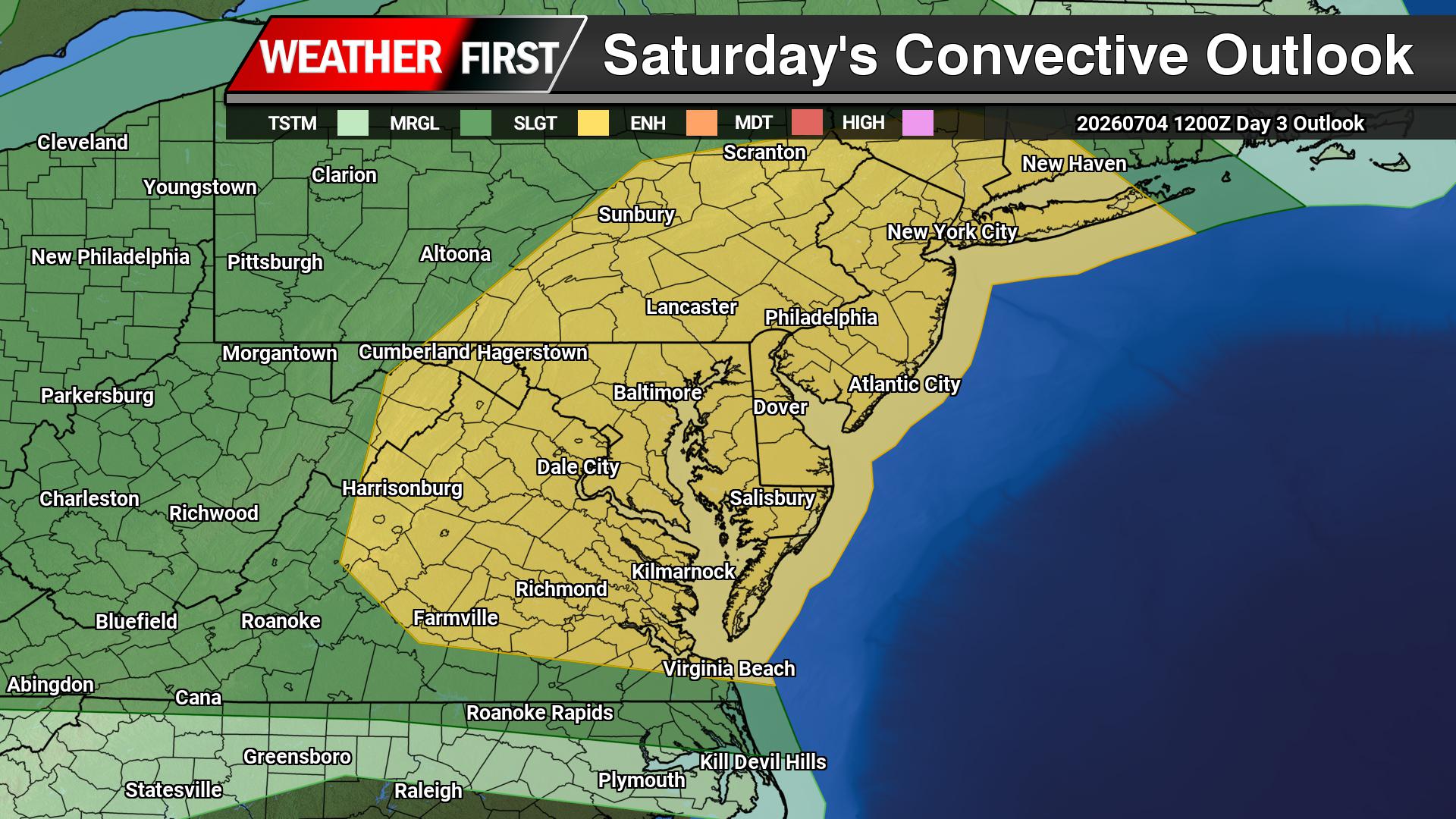
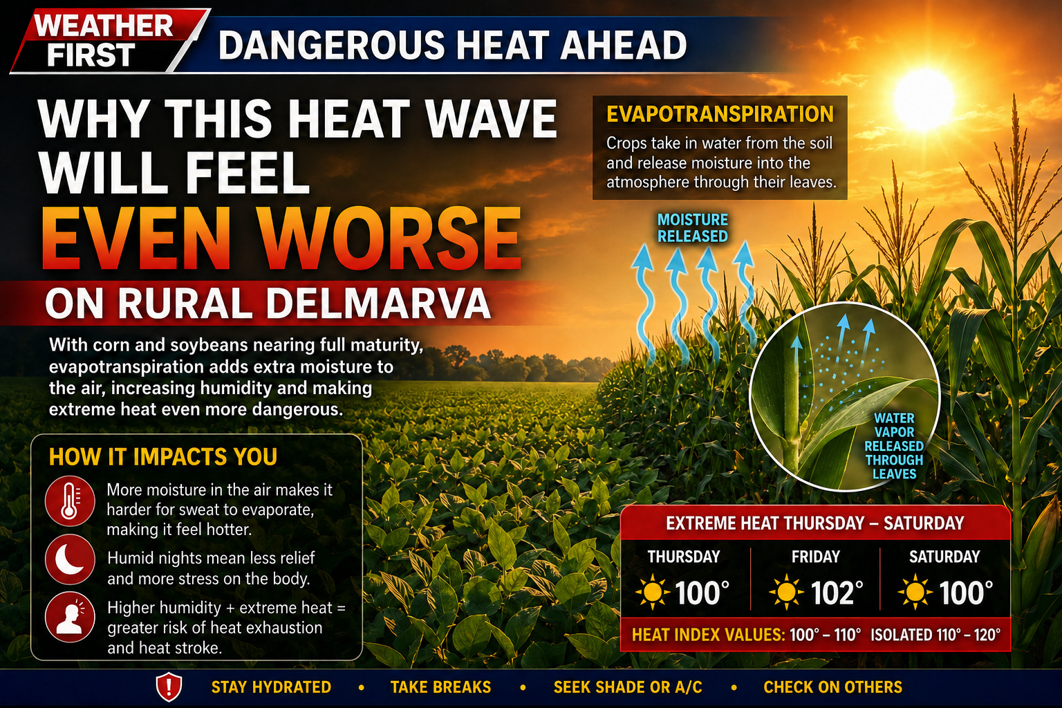
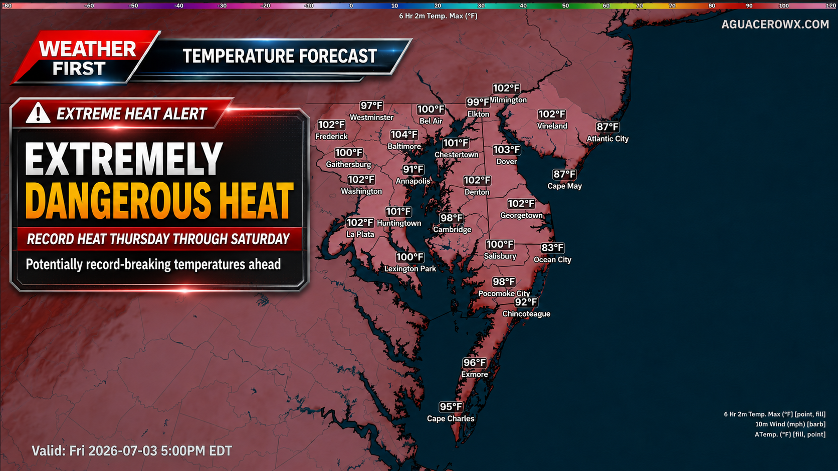
A more active weather pattern is expected to develop across Delmarva and the surrounding Mid-Atlantic through the holiday weekend, bringing increasing chances for afternoon and evening showers and thunderstorms. This comes as dangerous heat and humidity continue to impact the region, adding another concern for outdoor plans and holiday festivities.
The large ridge of high pressure responsible for the extreme heat is beginning to break down and shift back to the south and west. As this happens, a mid-level trough will dig southeastward into New England, allowing several disturbances to ride over the top of the ridge and move into the region. These disturbances will help trigger more showers and thunderstorms, especially during the afternoon and evening hours.
Storm chances will begin to increase late today, though coverage should remain more isolated to scattered. Rain chances are around 20 to 30 percent for this afternoon and evening. By Saturday, storm coverage should become a bit more widespread, with rain chances generally ranging from 30 to 60 percent. The most active period looks to arrive Sunday into Monday, when showers and storms could become more widespread across much of the area.
The Storm Prediction Center has placed portions of the region under a Slight Risk, level 2 out of 5, for severe thunderstorms today, Saturday, and Sunday. While storm coverage may be limited today, any storm that develops could become strong. By Saturday, storms may become more organized, with damaging wind gusts being the primary severe weather threat.
Sunday could bring a more focused severe weather risk across Delmarva as the atmosphere becomes unstable ahead of an approaching cold front. While the entire region may see showers and thunderstorms, Delmarva may have the better chance for stronger storms depending on how much heating and instability can develop during the day.
The timing and coverage of thunderstorms remains somewhat uncertain, but the main message is that holiday weekend plans could be impacted at times by storms, especially during the afternoon and evening. Anyone with outdoor events, beach plans, fireworks, or travel should stay weather aware and have a way to receive warnings.
After the cold front moves through Sunday, it may stall near or just south of the region. That stalled boundary, combined with another upper-level disturbance moving through, could lead to scattered to widespread showers and a few thunderstorms Sunday night through Monday night. Even after that, isolated daily storm chances may continue into the middle of next week, mainly during the afternoon and evening.
Along with the storm threat, dangerous heat remains a concern through Saturday. Heat index values could still climb into the 100 to 108 degree range Saturday, especially across inland areas. The combination of extreme heat, high humidity, and scattered storms will make it important to take precautions, stay hydrated, limit strenuous outdoor activity, and move indoors quickly when thunder is heard.
An Extreme Heat Warning has been issued by the National Weather Service out of Mount Holly, New Jersey, covering the area through the Fourth of July holiday.
The warning took effect on Thursday, July 3rd at 1:40 PM Eastern Time and is set to expire on Friday, July 4th at 8:00 PM Eastern Time.
Extreme Heat Warnings are issued when dangerously high temperatures pose a significant risk to public health. Residents should take steps to stay cool, stay hydrated, and check on vulnerable neighbors, elderly family members, and those without access to air conditioning.
If you must be outdoors, limit strenuous activity to the cooler morning hours and seek shade whenever possible. Never leave children or pets unattended in vehicles.
An Extreme Heat Warning has been issued by the National Weather Service out of Mount Holly, New Jersey, signaling a dangerous heat event for the area.
The warning took effect at 1:40 PM EDT on Thursday, July 3rd and is set to expire at 8:00 PM EDT on Friday, July 4th — meaning the dangerous conditions are expected to continue through much of the Independence Day holiday.
Residents should take steps to protect themselves from the extreme heat, including staying indoors in air-conditioned spaces, drinking plenty of water, and checking on elderly neighbors and relatives. Pets should not be left in vehicles, and outdoor activities should be limited during the hottest parts of the day.
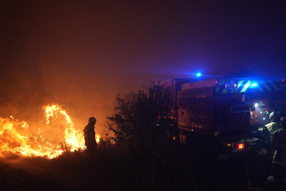
A raging wildfire burning southwest of Denver has driven thousands of residents from their homes and leveled more than 160 structures as of Friday, with unpredictable winds spreading the flames across two Colorado counties.
Known as the Aspen Acres fire, the blaze is one of approximately 40 large wildfires currently burning out of control, mostly across the western United States. Months of dry weather and historically low snowfall this past winter in some areas have created dangerous fire conditions.
Firefighters have been pulling water directly from the Pueblo Reservoir in their efforts to battle the blaze, which grew by 17 square miles — roughly 44 square kilometers — overnight. By Friday, the fire had reached nearly 105 square miles (272 square kilometers) in size with zero containment reported.
The Pueblo County Sheriff’s Office announced mandatory evacuations for all of Colorado City, an unincorporated community of approximately 2,200 people, along with the towns of Beulah, Rye, and San Isabel.
Around 50 National Guard soldiers were deployed Friday to assist with staffing road checkpoints throughout Custer and Pueblo counties. Guard members are also supporting State Park Rangers, who have added boats to keep recreational watercraft away from areas where aircraft are scooping water.
Meanwhile, on the western slope of the Rocky Mountains, crews have achieved roughly 65% containment of the Snyder Fire along the Colorado-Utah border. That fire drew national attention last weekend after three members of a Helitack team were killed and two others were injured when they were overtaken by flames.
Elsewhere in the region, the Cottonwood fire in southwestern Utah had grown to more than 147 square miles (380 square kilometers) by Friday, while the Babylon fire in the southeastern corner of the state had reached 133 square miles (344 square kilometers).
Tropical Storm Maysak made landfall along the southwestern coast of China’s Hainan island province on Friday evening, unleashing winds of up to 23 metres per second — roughly 51 miles per hour — and triggering widespread transportation shutdowns across the region.
China’s National Meteorological Center reported the storm came ashore at approximately 6:20 p.m. local time, which is 10:20 a.m. GMT.
In addition to Hainan, the storm is forecast to dump heavy rain on Guangdong, Guizhou, and Hunan provinces, as well as the Guangxi region. Some parts of Hainan could receive as much as 350 millimetres of rainfall within a single 24-hour period, according to the national weather forecasting agency.
State broadcaster CCTV reported that Hainan’s Sanya Phoenix International Airport halted all takeoffs and landings beginning at 5 p.m., following the earlier cancellation of 92 flights by 11:30 a.m. All round-island high-speed rail services were also shut down for the day.
Ferry crossings across the Qiongzhou Strait were suspended starting at 2 a.m. and are expected to remain out of service for one to two days.
Officials called on authorities to intensify monitoring efforts and carry out evacuations from vulnerable areas, describing the flood prevention situation as “severe and complex.”
Ratledge Road is closed between Coale Lane and Summit Bridge Road following a tree that has come down across the roadway.
Motorists traveling in that area are advised to seek an alternate route and allow extra time for their commute. Crews are expected to work to clear the obstruction, though no estimated time of reopening has been provided at this time.
Drivers should use caution near the affected area and watch for any traffic control measures that may be in place.
An Extreme Heat Warning has been issued by the National Weather Service out of Mount Holly, New Jersey, beginning at 3:19 AM on July 3rd and lasting through 8:00 PM on the evening of July 4th.
This type of warning is reserved for the most dangerous heat conditions, when high temperatures and humidity combine to create life-threatening situations. Residents should take steps to stay cool, stay hydrated, and check on vulnerable neighbors, family members, and pets during the duration of this warning.
Officials recommend limiting time outdoors during peak afternoon hours, seeking air-conditioned spaces when possible, and never leaving children or animals in parked vehicles.
An Extreme Heat Warning has been issued by the National Weather Service office in Mount Holly, New Jersey, covering the area through the Fourth of July holiday.
The warning took effect in the early morning hours of July 3rd at 3:19 AM EDT and is set to expire on July 4th at 8:00 PM EDT, meaning dangerous heat conditions are expected throughout the holiday period.
Extreme Heat Warnings are issued when dangerously hot conditions pose a significant risk to public health. Officials typically advise residents to stay indoors in air-conditioned spaces, drink plenty of water, check on elderly neighbors and relatives, and avoid prolonged exposure to the sun during the hottest parts of the day.
Anyone experiencing symptoms of heat-related illness, such as heavy sweating, weakness, dizziness, nausea, or confusion, should seek medical attention immediately.
HONOLULU (AP) — Residents of U.S. territories in the western Pacific are preparing for what could be another super typhoon, arriving just months after the most powerful tropical cyclone on the planet this year already tore through the region.
In the U.S. Commonwealth of the Northern Mariana Islands, electricity has still not been fully restored following Super Typhoon Sinlaku, which unleashed violent winds and heavy rainfall back in April. Some displaced residents continue to live in tents after their homes were completely destroyed.
“We’re getting ready to do this all over again,” said Edwin Propst, a former lawmaker who now works in the governor’s office on Saipan, where it was already Friday. “The timing is terrible.”
Typhoon Bavi is expected to intensify into a super typhoon by Sunday night through early Monday, which is when it is projected to arrive in the Marianas, according to Paul Stanko, a senior meteorologist with the National Weather Service based in Guam.
A tropical cyclone earns the designation of super typhoon when its maximum sustained winds reach at least 150 mph (241 kph). Stanko noted that super typhoons are comparable to a high-end Category 4 or Category 5 hurricane.
As of Friday, Bavi was located 760 miles (1,223 kilometers) east of Guam, carrying maximum sustained winds of 80 mph (129 kph), according to the weather service.
Stanko said some residents are actually hoping the storm tracks toward Guam rather than the Northern Marianas, which would give the harder-hit islands more time to recover from Sinlaku.
“That’s what we’re actually hoping for because then Saipan wouldn’t get it as bad,” Stanko said.
Propst said he was hearing the same sentiment from people on Guam as well.
“That’s so island-style,” he said. “God bless them for saying that.”
Guam lies west of the International Date Line and carries the nickname “Where America’s Day Begins” because it is several hours ahead of Hawaii, Alaska, and the continental United States. The island is also home to two major U.S. military installations.
Propst said residents were boarding up windows with plywood and stockpiling gasoline, recalling how gas station lines stretched on for weeks following Sinlaku.
The Rev. Francis Hezel, assistant pastor of Santa Barbara Catholic Church in Dededo, Guam, said he hopes no island takes a direct hit from the storm. Having lived through many typhoons, he said he wasn’t overly alarmed and remained hopeful that Bavi would shift course.
“Right now the pattern is heading towards us, but those patterns change,” he said.
Even so, church staff and community members were taking precautions.
“This is getting to be the normal thing now, typhoon preparedness,” Hezel said. “It’s happening more frequently.”
El Niño conditions are known to ramp up hurricane activity in the Pacific. Scientists say the El Niño warming cycle, combined with a planet already heating up due to fossil fuel emissions, is likely to intensify extreme weather events around the world.
Although Sinlaku caused no deaths on land, Propst said the community continues to grieve the six crew members of a cargo ship that capsized during the storm. Searchers recovered one body, but the U.S. Coast Guard called off the search — which had lasted more than 100 hours — before the remaining crew members were found.
Propst acknowledged that recovery from Sinlaku has come a long way, but said the islands are “not quite there yet.”
“A few more months would have been good,” he said.
Escaping the heat this Fourth of July weekend will be no easy feat for millions of people in the eastern United States, with some communities already scrapping or scaling back their Independence Day festivities because of dangerous conditions.
The National Weather Service issued a warning Thursday that hazardous, record-setting heat will continue across much of the central and eastern U.S. through Friday, with the East Coast expected to remain in the grip of extreme temperatures through the weekend. Forecasters called for highs in the upper 90s Fahrenheit across the Northeast, and both New York City and Boston hit 100 degrees on Thursday. When humidity is factored in, conditions will feel even more punishing — putting a damper on celebrations marking 250 years of American independence.
“Anywhere you go in southern New England, you will be dealing with dangerous heat today, tomorrow and Saturday,” said Bryce Williams, a meteorologist with the National Weather Service.
In Boston, organizers pushed back the gates-open time for the Boston Pops Fireworks Spectacular from noon to 4 p.m. on Saturday due to the heat. Philadelphia officials shortened the route of a Thursday morning parade, scrapped an afternoon all-American Block Party, and delayed the start times of an evening picnic and concert at Independence Mall.
In Lower Windsor Township, Pennsylvania, an America 250 celebration that was to include food trucks, games, and the highway department’s dump truck has been moved to July 8. Norristown, Pennsylvania canceled its Saturday parade entirely, citing concerns for the safety of residents, participants, and first responders — though evening fireworks and an afternoon event with games, food, and music are still set to take place.
“The parade is one of our community’s most beloved traditions, and we share in the disappointment of its cancellation, especially as we celebrate America’s 250th birthday,” said Interim Municipal Administrator Jayne Musonye.
Gettysburg National Military Park in Pennsylvania relocated outdoor programming to indoor venues. Amtrak also canceled several train routes Thursday due to the heat, including Acela service between Boston and Washington, and warned that other trains could run at reduced speeds, causing delays through Saturday.
A heat dome — a high-pressure system that traps heat and humidity over a region — has been bearing down on areas stretching from the Midwest to the East Coast. Beyond holiday events, officials in many communities have opened cooling centers for residents seeking relief. In Boston, several air-conditioned museums are offering free admission to city residents, while pools and waterparks in Providence, Rhode Island have extended their hours.
At a Philadelphia Phillies home game against the Pittsburgh Pirates on Wednesday, the temperature had already climbed to 98 degrees by first pitch. Sixteen pallets of bottled water were handed out to fans at no charge.
Bill Christy, 69, of Philadelphia, was making his way through the heat with two teenagers he had brought along for company. “They’re young, they can handle it,” he said. “I’ll just go up in the shade somewhere if I get hot.”
Nearby, a fife and drum corps was marching through the lower concourse in full uniform. “Usually it’s wool regimental. But this is linen, it’s cool,” said Debbie Mayes of Ewing, New Jersey, a member of the Washington Crossing Fife and Drums. “We’re fine. They’ve been very kind to us, letting us take breaks and providing water.”
In New York City, Taylor Swift fans were braving the heat outside Madison Square Garden, hoping to catch the superstar before her Friday wedding. Amanda Powell, visiting from Little Rock, Arkansas, admitted the conditions were tougher than expected. “It’s super hot,” she said. “Being from Arkansas, we thought we could handle the heat, but it’s been very warm.”
Central Park in Manhattan reached 100 degrees Thursday afternoon — the first time the famous park has hit triple digits since 2012, according to the National Weather Service.
At the Franklin Park Zoo in Boston, staff worked hard to keep animals comfortable in the extreme heat. Workers gave African penguins frozen blocks of ice packed with herring, offered frozen pellets to Nigerian dwarf goats, and tossed frozen treats into the enclosure of Western lowland gorillas, who eagerly scrambled to snatch them up.
“All of my animals have been doing a really great job of staying under the fan, staying near a sprinkler,” said zookeeper Brooke Cannon. “I’m running around with the hose hitting them a little bit here and there. Yeah, it’s not their favorite, but you know sometimes you got to do what you got to do to make sure that they’re not making poor choices.”
Despite the brutal conditions, the zoo drew plenty of visitors — though many were seen fanning themselves or standing under misters to find relief. Some were already regretting the trip. “It’s too hot in the summer and this is not the right time to come and visit zoo,” said Bhargavi Patha, who was visiting with her husband and 14-month-old son. “The heat is exhausting us. We are draining and we had to drink a lot of water to see all the animals.”
The heat wave is also putting pressure on electric grids across the region. New York Mayor Zohran Mamdani urged residents to set their air conditioners to 78 degrees to avoid overtaxing the power supply — a step previous mayors, including former Mayor Rudy Giuliani, have also recommended. The request drew criticism from conservative voices online. By early Thursday afternoon, New York Gov. Kathy Hochul, a Democrat, asked all state residents to raise their thermostats to 75 degrees or higher, limit unnecessary appliance use, and conserve electricity, citing high demand and what she called “unexpected load challenges.”
Florida Gov. Ron DeSantis, a Republican who frequently sparred with the mayor on social media, responded on X with: “Is this what was meant by the warmth of collectivism?” — a reference to a phrase the democratic socialist mayor used during his inaugural address.
The rapid expansion of data centers is adding further strain to the grid. Operators in New York state, New England, and the grid serving 13 mid-Atlantic and Midwestern states all projected electricity demand would peak Thursday before easing slightly on Friday. As of Thursday evening, no emergency calls had been issued to reduce consumption, even as usage ran roughly 40% above a typical summer day.
PJM Interconnection, which manages the grid serving 65 million people from New Jersey to Illinois, had anticipated Thursday would set an all-time summer electricity demand record, but usage ultimately fell just short of the mark set in 2006. In preparation, PJM secured an order from the U.S. Department of Energy allowing utilities to require data centers and other large power users to disconnect from the grid and switch to backup sources — such as diesel generators — before resorting to rolling blackouts.
A major Canadian hydropower transmission line supplying New York City went offline Wednesday due to an equipment failure in Canada, but operator Hydro-Québec reported the line was repaired and back in service by 12:30 p.m. Thursday.
An Extreme Heat Warning has been issued by the National Weather Service office in Mount Holly, New Jersey, covering a dangerous stretch of weather that will run from Wednesday, July 2nd at 1:30 PM Eastern Time through Friday, July 4th at 8:00 PM Eastern Time.
The warning signals that potentially life-threatening heat conditions are expected during this period, which coincides with the Fourth of July holiday weekend — a time when many people are likely to be spending time outdoors.
Residents are strongly encouraged to limit time outside during the hottest parts of the day, stay hydrated, and check on elderly neighbors, young children, and pets. Air-conditioned spaces such as libraries, shopping centers, and cooling centers can provide relief during the most intense heat of the day.
Those who must be outdoors should wear lightweight, light-colored clothing, apply sunscreen, and take frequent breaks in the shade or indoors. Never leave children or pets unattended in parked vehicles, as temperatures inside a car can rise to deadly levels within minutes.
Residents should monitor local forecasts closely and follow any additional guidance issued by the National Weather Service as the holiday weekend approaches.
The National Weather Service office in Mount Holly, New Jersey has issued an Extreme Heat Warning covering the area, running from 1:30 PM Eastern Time on Wednesday, July 2nd through 8:00 PM Eastern Time on Friday, July 4th.
An Extreme Heat Warning is the highest level of heat alert issued by the National Weather Service, reserved for dangerously hot conditions that pose a serious risk to public health. Residents should take the threat seriously and take steps to stay cool and hydrated throughout the holiday weekend.
Health officials generally advise people to stay indoors in air-conditioned spaces during the hottest parts of the day, check on elderly neighbors and relatives, and never leave children or pets in parked vehicles. Those who must be outdoors should drink plenty of water, wear lightweight clothing, and take frequent breaks in the shade.
The warning covers the July 4th holiday, when many people are expected to be outside for celebrations and fireworks events. Officials encourage the public to plan outdoor activities for the cooler morning hours and monitor local updates from the National Weather Service for any changes to the alert.
PARIS (AP) — Devastating wildfires swept through southern France on Thursday, driven by weeks of dry conditions and record-high temperatures that have left the landscape parched and vulnerable to flames.
The largest blaze broke out across the Aude and Herault regions, where local authorities deployed as many as 800 firefighters and 150 vehicles to battle fires that had already burned through more than 900 hectares — roughly 2,200 acres. Separate fires also ignited in the neighboring Marseille region, where two blazes were brought under control Thursday, though they had not been fully extinguished.
French Prime Minister Sebastien Lecornu reported that nearly 7,000 fires have erupted since the beginning of the summer season, scorching approximately 8,700 hectares of land. “The situation is fairly tense,” he said.
Four water-bomber aircraft were called in to assist ground crews in the Aude region. Aude prefect Alain Bucquet stressed the urgency of the response, telling France Info channel: “The idea is to bring the fire under control quickly because temperatures are rising and the wind is growing stronger.”
The Aude region has a long history with wildfires. Just last year, firefighters successfully contained what was described as France’s largest wildfire in decades in that same area.
Further south, fires raging near the seaside resort of Canet-en-Roussillon forced the evacuation of 1,500 residents from three campsites and destroyed hundreds of mobile homes. Regional prefect Pierre Regnault de la Mothe described firefighters as engaged in “a fierce struggle” to stop the flames from spreading into a nearby industrial zone.
Forecasters offer little relief, with no rain expected in the coming days. The fires follow heat waves that struck in May and again at the end of June. Vegetation across the Mediterranean region is under severe water stress, and strong winds continue to fan the danger.
A dangerous heat wave is gripping much of the Eastern United States, and while scorching daytime temperatures are grabbing headlines, health experts are sounding the alarm about something else: the nights are not cooling down either.
Across a wide stretch of the country, from the Midwest all the way to the East Coast, temperatures are expected to climb past 100 degrees — with up to 90 million Americans feeling the effects of the extreme heat.
But the problem does not end when the sun goes down. Nighttime temperatures are staying unusually elevated, and that is creating a serious health concern. When the body cannot cool itself overnight, it never fully recovers from the stress of the daytime heat — and that can become life-threatening, especially for vulnerable populations.
Experts say this combination of relentless daytime highs and warm overnight lows is what makes this particular heat event especially dangerous for millions of people.
CONCORD, N.H. — A suffocating heat wave is descending on the eastern United States just in time for the Fourth of July holiday weekend, forcing some communities to scrap, delay, or significantly change their Independence Day festivities.
The National Weather Service warned Thursday that dangerously high, record-breaking temperatures will persist across much of the central and eastern U.S. through Friday, with the heat continuing along the East Coast through the weekend. The Northeast is expected to see temperatures in the upper 90s Fahrenheit — around 30 degrees Celsius — while cities like Philadelphia and Boston could push past 100 degrees. High humidity will make conditions feel even more brutal, threatening to put a damper on celebrations commemorating 250 years of American independence.
Philadelphia officials responded by shortening the route of a Thursday morning parade, calling off an afternoon all-American Block Party, and pushing back start times for an evening picnic and concert at Independence Mall.
In Lower Windsor Township, Pennsylvania, an America 250 event that was to feature food trucks, games, and the highway department’s dump truck has been moved to July 8. Over in Norristown, Pennsylvania, a Saturday parade was called off due to concerns about the safety of residents, participants, and first responders. However, evening fireworks along with an afternoon gathering with games, food, and music are still expected to proceed.
“The parade is one of our community’s most beloved traditions, and we share in the disappointment of its cancellation, especially as we celebrate America’s 250th birthday,” said Interim Municipal Administrator Jayne Musonye.
Amtrak also announced Thursday that it was canceling certain train routes because of the extreme heat, including the Acela service between Boston and Washington. The rail service added that other trains may run at reduced speeds, causing delays through Saturday.
The culprit behind the miserable conditions is a heat dome — a high-pressure system that settles over a region and traps heat and humidity underneath it — that has been smothering areas from the Midwest to the East Coast. Beyond the impact on holiday events, local officials across many areas are opening cooling centers and taking other steps to protect residents. In Boston, several air-conditioned museums are opening their doors free of charge to city residents to help them escape the heat.
As temperatures soared in New York, Mayor Zohran Mamdani called on residents to set their air conditioners to 78 degrees to reduce strain on the power grid — a recommendation that past mayors, including former Mayor Rudy Giuliani, have also made during heat events. The appeal, however, drew sharp criticism from the Democratic mayor’s conservative opponents on social media.
Florida Gov. Ron DeSantis, a Republican who frequently takes jabs at the mayor on social media, fired back on X with the question, “Is this what was meant by the warmth of collectivism?” — turning a phrase the democratic socialist had used during his inaugural address back against him.
A more unsettled pattern is expected to develop across the Mid-Atlantic starting Friday and continuing into the holiday weekend, bringing the potential for afternoon and evening thunderstorms on top of the ongoing extreme heat.
A strong mid-level ridge responsible for the dangerous heat will begin to break down and shift back toward the south and west late this week. As that happens, troughiness will develop over the Northeast while several shortwaves ride over the top of the ridge and into the region. That pattern should support increasing chances for showers and thunderstorms Friday through Monday, with the greatest coverage currently expected Saturday through Monday.
Friday’s thunderstorm coverage is still expected to be somewhat limited, with storms mainly isolated to scattered during the afternoon and evening. However, the environment will be capable of producing strong to severe storms where development occurs. Temperatures near 100 degrees combined with dewpoints in the 60s will create strong instability, while large temperature and dewpoint spreads may allow storms to produce efficient damaging downburst winds. The Storm Prediction Center notes that clusters or linear segments could develop, especially across the northern Mid-Atlantic, where stronger flow aloft will be present.
By Saturday, storm coverage is expected to become more widespread as a cold front and surface trough provide better forcing. Strong heating of a very moist air mass may support 3,000+ J/kg of MLCAPE by the afternoon. Even with weaker wind shear, low-level inverted-v profiles will favor strong to severe downburst winds. The SPC has placed parts of the Mid-Atlantic in a Slight Risk, level 2 out of 5, for severe thunderstorms Saturday, with damaging winds again the primary concern.
Sunday may bring even higher storm coverage as modest mid-level height falls approach the region and the surface front stalls nearby. The SPC has added a 15% severe risk for the Mid-Atlantic on Sunday, with damaging wind gusts continuing to be the main hazard.
The timing of storms each day will favor the afternoon and evening hours, which could create problems for outdoor holiday weekend plans, including cookouts, beach trips, fireworks events and travel. Not everyone will see storms each day, but any storm that does develop could quickly become strong with damaging wind gusts, frequent lightning and heavy downpours.
This severe weather threat will also come during a period of extreme heat. The National Weather Service Mount Holly briefing shows high temperatures through Saturday generally ranging from 95 to 105 degrees for most areas, with daytime heat index values between 100 and 110 degrees and isolated values up to 115 degrees possible. Overnight lows only falling into the mid 70s to low 80s will provide little relief.
Residents and visitors across Delmarva and the broader Mid-Atlantic should have multiple ways to receive weather alerts through the weekend. Outdoor plans should include a heat safety plan and a thunderstorm safety plan. When thunder roars, move indoors, and never take shelter under trees, tents or open pavilions during a storm.
Forecast details will continue to change, especially regarding storm coverage and placement each day, so check for updates before heading out for holiday weekend events.
The National Weather Service office in Mount Holly, New Jersey has issued an Extreme Heat Warning for the region, set to remain in effect from 3:51 a.m. on Wednesday, July 2nd through 8:00 p.m. on Friday, July 4th.
The warning covers a multi-day stretch of dangerous heat that coincides with the Fourth of July holiday weekend, when many people may be spending extended time outdoors for celebrations and activities.
Residents are strongly encouraged to limit time outside during peak afternoon hours, stay hydrated, and check on elderly neighbors, young children, and pets who may be especially vulnerable to extreme heat conditions.
If you do not have access to air conditioning at home, consider visiting a local cooling center during the hottest parts of the day. Heat-related illnesses such as heat exhaustion and heat stroke can develop quickly and become life-threatening.
Stay with TV Delmarva for continuing updates on this Extreme Heat Warning and any changes to the forecast throughout the holiday weekend.
The National Weather Service office in Mount Holly, New Jersey has issued an Extreme Heat Warning for the region, effective from 3:51 AM on Wednesday, July 2nd through 8:00 PM on Friday, July 4th.
An Extreme Heat Warning is the highest level of heat alert issued by the National Weather Service and signals that dangerously hot conditions are expected. These conditions can pose a serious risk to public health, particularly for the elderly, young children, and those with underlying medical conditions.
Residents are strongly encouraged to stay indoors in air-conditioned spaces during the hottest parts of the day, drink plenty of water, and check on neighbors and loved ones who may be vulnerable to extreme heat. Never leave children or pets unattended in vehicles.
The warning covers the Fourth of July holiday weekend, when many people may be spending extended time outdoors for celebrations. Officials recommend limiting outdoor activities and taking frequent breaks in cool or shaded areas if you must be outside.
For the latest updates and safety information, residents should monitor forecasts from the National Weather Service.
Firefighters in the Aude region of southern France spent Thursday struggling to get a wildfire under control, as the country continued to deal with the fallout from a recent European heatwave.
Officials from the local administration in the Aude area, which sits near the border with Spain, posted on X that weather conditions were still working against crews on the ground. High winds, they warned, posed a serious risk of spreading the fire further.
Meanwhile, crews in the Lancon area of southern France reported better news — a separate wildfire there had been successfully contained, according to the local fire brigade.
France’s national weather office has issued a warning that the region could face yet another intense heat event as soon as next week, raising concerns that fire conditions may worsen before they improve.
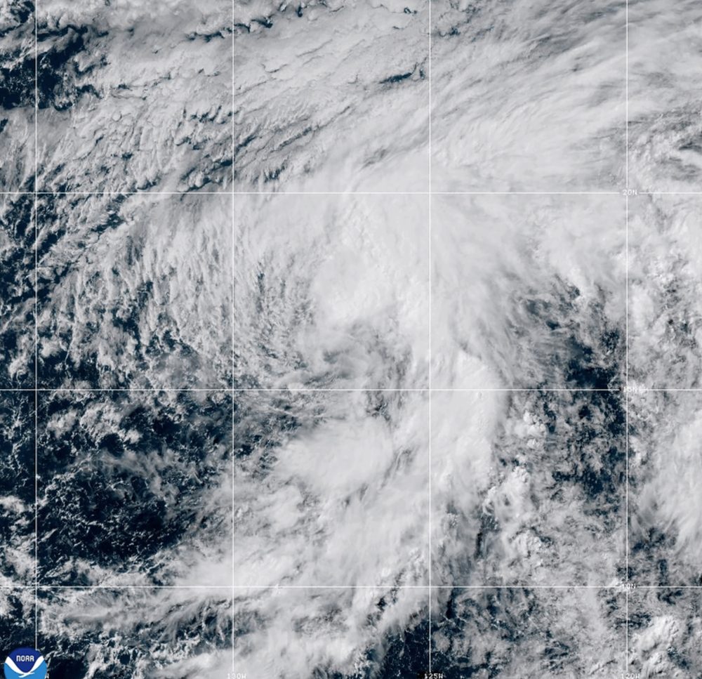
Tropical Storm Douglas came to life Wednesday in the Pacific Ocean, according to the National Hurricane Center — though residents along any coastline have nothing to worry about.
The storm’s center remains entirely at sea, sitting roughly 1,220 miles west-southwest of the southern tip of Mexico’s Baja California peninsula. No land areas are currently under threat from the system.
As of the latest update, Douglas is packing maximum sustained winds of around 40 mph, with occasional stronger gusts. The storm has been tracking northward at about 7 mph, and forecasters say a gradual shift toward the northwest is anticipated later this week.
Tropical-storm-force winds are reaching outward up to 90 miles from the storm’s center. The National Hurricane Center noted that Douglas could gain some strength Wednesday night before beginning to weaken on Thursday.
Of all the weather hazards that threaten communities, flash floods rank among the most dangerous — and the most difficult to predict. Unlike hurricanes or winter storms that can be tracked days in advance, flash floods can develop in a matter of minutes, leaving little time for people to reach safety.
Forecasters who specialize in flash flood prediction face a unique challenge: they must combine an understanding of rainfall intensity, soil conditions, terrain, and stream behavior to estimate where and when dangerous flooding might occur — often with very limited lead time.
The science behind flash flood forecasting involves monitoring how much rain is falling in a given area, how quickly the ground can absorb that water, and how fast runoff will travel into streams and low-lying areas. When rainfall overwhelms the ground’s ability to soak up water, the excess rushes downhill and can quickly fill valleys, roadways, and neighborhoods with dangerous, fast-moving water.
One of the greatest challenges is that flash floods are highly localized. A storm that drops several inches of rain in one neighborhood may leave a nearby area completely dry. This makes it difficult to issue warnings that are both specific enough to be useful and broad enough to protect everyone at risk.
Advances in radar technology and computer modeling have improved forecasters’ ability to detect dangerous conditions earlier, but experts acknowledge that significant uncertainty remains. Even with the best available tools, predicting exactly where and when a flash flood will strike is far from a perfect science.
Public awareness plays a critical role in keeping people safe. Meteorologists urge residents to take flash flood warnings seriously and to never attempt to drive through flooded roadways — a decision that accounts for a significant share of flood-related deaths each year. The phrase “turn around, don’t drown” has become a cornerstone of public safety messaging for exactly this reason.
As extreme rainfall events become more frequent in many parts of the country, the stakes for accurate flash flood forecasting continue to grow. Researchers and weather agencies are investing in better tools and communication strategies to help communities respond more quickly when dangerous conditions develop.
Multi-day extreme heat warnings went into effect Wednesday for New York, Boston, and Philadelphia as a wave of dangerous heat swept eastward just in time to disrupt Fourth of July festivities in a region steeped in American independence history.
The National Weather Service is forecasting temperatures in the high 90s Fahrenheit — around 30 degrees Celsius — across the Northeast. Philadelphia and Boston could push past 100 degrees by Thursday. Factor in the humidity, and the heat index will feel even more punishing at times.
A heat dome — a weather pattern in which high-pressure systems sit over a region and trap heat and moisture below — has been bearing down on a wide swath of the country, stretching from the Midwest all the way to the East Coast. The oppressive conditions are expected to cast a shadow over 250th anniversary Independence Day events, including parades, ship flotillas, outdoor concerts, and a public reading of the Declaration of Independence from a historic balcony in Boston on Saturday.
New York Mayor Zohran Mamdani urged city residents to seek cool spaces indoors and steer clear of what he called “extraordinary temperatures.”
“To be breaking into triple digits over the course of these many next days — it is of immense concern given that too often the heat is something that is underestimated,” Mamdani said.
In Hamptonburgh, New York, the air conditioning system failed aboard a bus transporting Junior ROTC cadets, leaving several with heat-related illnesses, according to Orange County authorities. Some of the cadets were transported to hospitals as a precautionary measure.
While humidity is nothing new in the Northeast, Dr. Alexander Azan of NYU Langone Health in New York cautioned that the combination of high air temperatures and elevated humidity can be especially dangerous for people in the region.
“Their body doesn’t have that level of acclimatization to respond appropriately to the heat, and so heat stress in the form of what we call heat exhaustion, and in more severe cases, heat stroke, can occur at much lower temperatures than we see in people who live in the South,” Azan said.
Experts point out that urban areas face even greater risks during heat events. Vijay Limaye, a climate scientist at the Natural Resources Defense Council, explained that the built environment itself intensifies the danger.
“The concentration of concrete, asphalt, steel, all of those materials help to retain heat,” Limaye said. “The number on your phone may actually not reflect the true temperature profile that you’re going out into.”
New York City announced that more than 200 teams of city workers and volunteers would fan out to check on people experiencing homelessness and encourage them to get indoors. Hundreds of cooling centers are being made available across the city, ranging from the Javits Center convention hall to mobile vans and outdoor areas equipped with misting fans.
The American Kennel Club’s Museum of the Dog in New York is opening its doors to visitors and their dogs through Sunday, giving four-legged companions a chance to cool down. Executive Director Christopher Bromson said the idea came to him after watching his own Newfoundland stretched out on the museum’s cool floor.
“I thought every dog should have access to this,” he said.
In Washington, D.C., where temperatures reached 95 degrees Fahrenheit (35 degrees Celsius), children waiting in line for the Ferris wheel on the National Mall were seen grabbing cold water bottles handed out by U.S. Park Police.
Out in the Midwest, heat dangers continued as well. Taylor Harnist, who runs a Cincinnati business that installs and fixes air conditioning systems, said he has been making sure his crew takes regular breaks and stays hydrated with water and electrolyte drinks.
“You get an attic job when it’s this hot, we do them but it’s strenuous,” Harnist said. “It’s so hot the attics will reach temperatures of 145 degrees.”
Jeff Schlegelmilch, an associate professor at Columbia University Climate School, said extreme heat is among the clearest indicators of climate change.
“We have seen a continued increase in longer summers, hotter temperatures, hotter temperatures earlier on, more evaporation of moisture, higher humidity — effects like that,” he said.
The National Weather Service has raised the stakes on its heat alert for Delaware, upgrading the existing advisory to an Extreme Heat Warning for all three counties in the state.
The warning took effect this afternoon on July 1st and will remain in place through July 4th. Forecasters say the most intense and dangerous heat is expected to arrive on Thursday and Friday.
An Extreme Heat Warning is only declared when life-threatening heat conditions are either already underway or are considered imminent. Residents across Delaware are urged to take the threat seriously and take precautions to stay safe during the holiday weekend.
Travelers on northbound Route 1 between Rehoboth Avenue Extension and DE-24 should expect some extra time behind the wheel, as congestion is currently causing delays of roughly 5 to 10 minutes along that corridor.
The slowdown is attributed to traffic congestion in the area. No additional details regarding the cause of the backup were provided.
Drivers are encouraged to allow extra travel time or consider alternate routes if possible.
An Extreme Heat Warning has been issued by the National Weather Service out of Mount Holly, New Jersey, taking effect at 1:18 PM Eastern Time on July 1st and running through 8:00 PM Eastern Time on July 4th.
The warning covers the Independence Day holiday weekend, meaning dangerous heat conditions are expected to persist through one of the busiest outdoor celebration periods of the summer.
Residents are encouraged to stay hydrated, limit time outdoors during peak afternoon hours, and check on elderly neighbors, young children, and pets who may be especially vulnerable to extreme heat. If you do not have air conditioning at home, consider visiting a cooling center or public building during the hottest parts of the day.
Heat-related illness can develop quickly. Warning signs of heat exhaustion include heavy sweating, weakness, cold or pale skin, a weak pulse, nausea, and fainting. Heat stroke — which is a medical emergency — can cause a high body temperature, hot and red skin, a rapid pulse, and unconsciousness. If you suspect heat stroke, call 911 immediately.
Stay tuned to TV Delmarva for the latest updates on this Extreme Heat Warning as the holiday weekend approaches.
The National Weather Service office in Mount Holly, New Jersey has issued an Extreme Heat Warning for the area, effective starting July 1st at 1:18 PM Eastern Time and running through July 4th at 8:00 PM Eastern Time.
The warning covers what is expected to be a prolonged and potentially dangerous stretch of extreme heat coinciding with the Independence Day holiday weekend — a time when many residents and visitors are likely to be spending extended time outdoors.
Health and safety officials generally urge residents to drink plenty of water, avoid strenuous outdoor activity during the hottest parts of the day, check on elderly neighbors and relatives, and seek air-conditioned spaces when possible during periods of extreme heat.
Residents should monitor updates from the National Weather Service and local emergency management officials as the holiday weekend approaches.
A deadly storm swept through Bucharest, Romania’s capital city, overnight into Wednesday, leaving one person dead and causing widespread flooding across 20 counties — all coming on the heels of a brutal heatwave that had gripped the region.
The intense storm impacted 60 communities throughout the country. According to Romania’s General Inspectorate for Emergency Situations, known as the IGSU, emergency crews had to pump standing water out of more than 350 homes and clear flooding from over 100 streets.
The areas hardest hit were Bucharest and the neighboring Ilfov County. In that area, one person lost their life after a falling tree crushed their vehicle. Emergency services fielded more than 2,200 calls for assistance, and additional rescue teams, trucks, water pumps, and chainsaws were brought in from other parts of the country to help manage the damage.
The IGSU reported that nearly 1,000 trees — 988 in total — came down during the storm, and 495 vehicles sustained damage.
Romania had been enduring a heatwave similar to what much of Europe experienced this week, with temperatures in some regions expected to climb above 40 degrees Celsius, or 104 degrees Fahrenheit.
On Wednesday, Romania’s National Meteorological Administration issued a warning that “atmospheric instability” would continue to bring heavy rains and thunderstorms to the western and southern regions of the country.
The National Weather Service has put an Extreme Heat Warning into place for New Castle County and the surrounding region, covering a stretch that runs from this Wednesday through the Fourth of July holiday.
The warning took effect at noon on Wednesday, July 1, 2026, and is set to remain active until 8:00 PM on Saturday, July 4, 2026. That means dangerous heat conditions are expected to grip the area for the entire holiday weekend.
Forecasters are warning that heat index values — which reflect how hot it actually feels when humidity is factored in — are anticipated to climb to hazardous levels during this period. Residents are urged to take the warning seriously and take steps to stay safe in the extreme heat.
Officials recommend staying indoors during the hottest parts of the day, drinking plenty of water, and checking on elderly neighbors, young children, and pets. Cooling centers may be available in the area for those without access to air conditioning.
MADRID — Spanish health officials have linked more than 1,000 deaths to extreme heat last month, according to government figures released Wednesday. A five-day heatwave that saw temperatures climb above 40 degrees Celsius — or 104 degrees Fahrenheit — made June the second-hottest such month ever recorded in the country.
The Health Ministry’s daily mortality tracking system, known as MoMo, showed that 1,029 excess deaths were attributable to the heat during June. That marks the highest number of heat-linked deaths in that month since June 2015.
The national weather agency, AEMET, reported that average temperatures last month ran 3.2 degrees above normal levels, ranking it as the second-hottest June on record, trailing only June 2025.
At the height of the heatwave on June 23, approximately 35.7 million people — around 73 percent of Spain’s total population — faced health risks from the heat. Of that group, 38 percent were considered to be at high risk.
AEMET spokesperson Ruben del Campo said the pattern reflects a troubling shift in climate trends. “This is evidence that heatwaves appear at the beginning of summer with a higher frequency than before,” he said.
Historical data backs that up: of the 12 heatwaves recorded in June since 1975, half have occurred within the last ten years. Additionally, every one of the 13 hottest June months since records began in 1961 has taken place in the 21st century.
Throughout the month of June, weather stations across Spain shattered temperature records. A total of 165 maximum temperature records were broken — 145 of them monthly records and 20 all-time highs. An additional 225 records for the highest overnight low temperatures were also set, including 180 monthly records and 45 all-time marks.
AEMET described the season’s first heatwave as particularly remarkable in northern Spain, noting it stood out “not only because of its intensity, but also because of its duration and persistence.”
A destructive storm ripped through Bucharest, Romania, and 20 surrounding counties on Wednesday, claiming one life and damaging countless homes and vehicles, according to emergency services officials.
In Bucharest alone, emergency services received close to 2,000 calls for assistance, officials told the broadcaster Digi24. Multiple metro stations throughout the capital were submerged in floodwaters.
Beyond the city limits, the storm left a trail of destruction across 60 towns and villages. One fatality was recorded after a falling tree crushed a person’s vehicle.
Law enforcement and fire crews were dispatched across multiple counties to help evacuate residents from flooded properties and remove debris from affected areas.
The severe storm arrived on the heels of an intense heat wave that had gripped parts of Romania, with temperatures climbing past 40 degrees Celsius on Monday and Tuesday. The extreme heat had already strained the country’s power grid and driven electricity prices higher before the storm struck.
An Extreme Heat Warning has been issued by the National Weather Service office in Mount Holly, New Jersey, set to take effect at 3:15 AM Eastern Time on July 1st and remaining in place until 8:00 PM Eastern Time on July 4th.
The warning covers a multi-day stretch that includes the Fourth of July holiday weekend, a time when many people are expected to be outdoors for celebrations and festivities.
Extreme Heat Warnings are issued when dangerously high temperatures and heat index values pose a significant risk to public health. Officials typically advise residents to stay indoors in air-conditioned spaces, drink plenty of water, check on elderly neighbors and relatives, and limit strenuous outdoor activity during the hottest parts of the day.
Residents should monitor updates from the National Weather Service and local emergency management officials as the holiday weekend approaches.
An Extreme Heat Warning has been issued by the National Weather Service office in Mount Holly, New Jersey, set to take effect at 3:15 AM Eastern Time on July 1st and running through 8:00 PM Eastern Time on July 4th.
The warning covers what is expected to be a prolonged and dangerous period of extreme heat coinciding with the Independence Day holiday weekend. Residents are urged to take the threat seriously, as extreme heat is one of the leading weather-related causes of illness and death.
Health officials generally advise staying indoors in air-conditioned spaces during the hottest parts of the day, drinking plenty of water, and avoiding strenuous outdoor activity. Those without access to air conditioning should seek out cooling centers in their communities.
Please check on elderly family members, young children, and neighbors who may be especially vulnerable to heat-related illness. Never leave children or pets inside parked vehicles, even briefly, as temperatures inside can become life-threatening within minutes.
Stay with TV Delmarva for continuing updates on this Extreme Heat Warning throughout the holiday weekend.
As temperatures rise to potentially dangerous levels, officials are calling on residents to take steps to protect themselves and those around them.
Authorities are reminding the public that extreme heat can be life-threatening, particularly for older adults, young children, and individuals with certain medical conditions. Taking simple precautions can make a significant difference in staying safe during a heat event.
Residents are encouraged to drink plenty of water throughout the day, even if they do not feel thirsty, and to avoid spending extended periods outdoors during the hottest parts of the day. Those who must be outside are advised to wear lightweight, light-colored clothing and take frequent breaks in shaded or air-conditioned areas.
Officials also stress the importance of checking on elderly relatives, neighbors, and others who may be more vulnerable to heat-related illness. If you know someone who does not have access to air conditioning, consider reaching out to see if they need assistance finding a cool place to stay.
Never leave children or pets unattended in parked vehicles, as temperatures inside a car can rise to deadly levels within minutes, even on a moderately warm day.
Anyone experiencing symptoms of heat exhaustion or heat stroke — such as heavy sweating, dizziness, confusion, or loss of consciousness — should seek medical attention immediately.
Sussex County officials are urging residents and visitors to take the upcoming heat wave seriously, as forecasters warn of a dangerous stretch of hot weather set to arrive just in time for the Fourth of July holiday.
Beginning Wednesday, July 1, a punishing heat wave is expected to settle over Sussex County and much of the eastern United States, with temperatures projected to climb above 100 degrees. When humidity is factored in, the heat index could soar as high as 115 degrees — making this the hottest holiday weekend of the summer so far. The National Weather Service has placed the area under an extreme heat watch through Independence Day. While scattered showers and thunderstorms may offer brief moments of relief, the oppressive heat and humidity could stick around into early next week.
To help people cope with the extreme conditions, Sussex County announced Tuesday that a number of air-conditioned facilities will serve as cooling stations from July 1 through July 5. Normally, county buildings including libraries are available during regular business hours throughout the summer as cooling spots, but the long holiday weekend means most public offices will be closed. To fill that gap, the County Administrative Offices building on The Circle in Georgetown will remain open from 8:30 a.m. to 4:30 p.m. Wednesday through Sunday.
Several library branches will also be open on a limited basis during the heat emergency. The Greenwood Library at 100 Mill St. in Greenwood and the Milton Library at 121 Union St. in Milton will both be open from 10 a.m. to 6 p.m. on Wednesday and Thursday, then closed Friday through Sunday. The South Coastal Library at 43 Kent Ave. in Bethany Beach will be open from 10 a.m. to 7 p.m. on Wednesday and Thursday, then closed the rest of the weekend.
The State of Delaware has also announced cooling stations at select state facilities. For more details, call 2-1-1 or check the state’s website.
Sussex County EMS will nearly double its staffing levels during the holiday period. Paramedics will make routine stops at county cooling facilities, as schedules allow, to field any heat-related questions or concerns. Free individual bottles of water will also be available at these locations. Anyone visiting a cooling station is encouraged to bring any needed medications or specialty items.
County officials are advising everyone to limit time outdoors, especially between roughly 1 p.m. and 6 p.m., when temperatures will be at their peak. County Emergency Managers are also strongly encouraging organizers of Fourth of July events to keep a close eye on the forecast and consider rescheduling activities to cooler parts of the day. Anyone who must be outside during the hottest hours should take frequent breaks and drink plenty of water.
Hot Weather Safety Tips:
Wear lightweight, light-colored clothing, since lighter fabrics reflect sunlight rather than absorbing heat. Stay in well-ventilated areas and avoid physically demanding activity during the hottest hours of the day. Drink plenty of water and steer clear of alcoholic beverages.
Know the warning signs of heat-related illness. Heat cramps can cause muscle pain and spasms during heavy exertion — resting somewhere cooler, sipping water, and gently stretching the affected muscle can help. Heat exhaustion and heat stroke are far more serious. Heat exhaustion may cause a pale or flushed face, headache, and nausea. Heat stroke symptoms include a rapidly rising body temperature, loss of consciousness, a rapid or weak pulse, and quick, shallow breathing. Seek medical attention immediately if heat stroke is suspected.
Check in on friends, family, and neighbors — especially the elderly and young children — who may be more vulnerable to extreme heat. Don’t forget pets: give them extra water, provide shade, or bring them inside where it’s cooler.
Conserving Electricity During the Heat Wave:
With temperatures expected to spike, electricity demand will rise sharply. Sussex County Emergency Management is asking all residents and businesses to help prevent power outages by conserving energy wherever possible.
At home, set air conditioners to 80 degrees or use fans as an alternative, and try to limit how often you open the refrigerator or freezer. Turn off water heaters and non-essential appliances and lights. Hold off on running high-energy appliances like washing machines and dryers until after 8 p.m. Opt for light meals that require little cooking — an outdoor grill or microwave uses far less energy than an electric range. Keep blinds, shades, and drapes closed during the hottest part of the day to block out sunlight. Move lamps, televisions, and other heat-generating items away from air conditioner thermostats, since the heat they emit can cause the AC to run longer than needed. Also make sure furniture and other objects aren’t blocking central air conditioning vents, so cool air can flow freely through your home.
Businesses can do their part by raising thermostats slightly and switching off any lighting or equipment that isn’t necessary.
Sussex County is also reminding residents to take advantage of the county’s free Smart911 service by creating a safety profile for their household. These profiles give first responders potentially life-saving details in an emergency, including property information, special medical needs, and family contacts. Visit www.smart911.com to sign up.
Sussex County Emergency Management will continue tracking the situation and will release updates as conditions develop. For the latest information, follow the county’s emergency management pages on Facebook at www.facebook.com/SussexCountyPublicSafety and on X at www.x.com/SussexCtyDE_EM.
Millions of people across the Midwest and Great Lakes states are enduring brutal heat and humidity Tuesday, with no quick end in sight before the oppressive conditions push eastward toward the Atlantic coast.
The National Weather Service pulled no punches in its assessment, describing the situation as “dangerous.” Heat index readings — which factor in both air temperature and moisture in the air — topped 100 degrees Fahrenheit (37.8 degrees Celsius) in several locations. Officials warned that the conditions pose a serious risk for heat-related illness, particularly for those without access to air conditioning.
In Detroit, air temperatures climbed into the high 90s and could potentially hit 100 degrees at some point through Thursday. City officials responded by opening a dozen recreation centers to the public as cooling refuges, with some staying open as late as 11 p.m. Large portions of Michigan, along with Illinois, Ohio, Indiana, Kentucky, and much of Iowa, are under an extreme heat warning.
The heat wave is expected to move into the Northeast next, with cities like New York and Boston set to experience the worst of it around the Fourth of July holiday. In Norristown, Pennsylvania — about 20 miles (32 kilometers) outside Philadelphia — officials have already canceled a Saturday parade due to the anticipated weather.
In Chicago, the History Museum opened its doors free of charge to Illinois residents Tuesday, offering a cool escape from the heat. The extreme temperatures also caused roads in parts of Illinois to buckle and crack, a phenomenon that occurs when pavement has no room to expand in the heat and forces itself upward.
Detroit window washer Stephen Mason, 72, was already on the job at 9:15 a.m., cleaning mayflies off the glass of a local convenience store. He started early to get ahead of the worst of the day’s heat — but even then, temperatures had already reached 85 degrees (29.4 C).
“It’s the only way to beat it. But it’s already starting to cook out here,” Mason said.
Nearby in Detroit’s Indian Village neighborhood, 36-year-old runner Adam Schubatis was pushing through a shortened route of just 6 miles (9.6 kilometers), going shirtless to cope with the heat.
“I know where all the drinking fountains are,” he said. “My wife thought I was crazy. She offered to pick me up if I got tired or if there was anything I was doing that wasn’t safe.”
In Milwaukee, more than 100 firefighters battled a school fire for hours in the sweltering heat. Fire Chief Aaron Lipski said crews were rotating shifts and removing their heavy protective coats to rehydrate throughout the effort.
In Grosse Pointe Park, a suburb of Detroit, 64-year-old George Liller stepped up to help his neighbors. After installing air conditioning in his own home, he posted a spare window unit on Facebook — free to whoever needed it, extension cord and remote control included.
“It was probably on my porch maybe 15 minutes,” Liller said. “That air conditioner was given to me. I thought, ‘Somebody needs it.’ I know how it feels to be in an old house when it’s this hot.”
If you’re planning to celebrate the Fourth of July outdoors this year, be prepared for some dangerously hot conditions. The National Weather Service has put heat warnings and watches in place across large portions of the Midwest and East Coast as the holiday weekend approaches.
Meteorologists warn that temperatures in many of these areas could climb high enough to break existing records. Residents are being urged to take precautions, stay hydrated, and limit time spent outside during peak heat hours.
A photo from Chicago captured residents seeking relief at the fountain in Millennium Park as temperatures climbed above 90 degrees earlier this week, offering a preview of what much of the country may experience heading into the holiday.
The National Weather Service office in Mount Holly, New Jersey has issued an Extreme Heat Watch, effective starting June 30th at 1:31 PM Eastern Time and continuing through July 4th at 8:00 PM Eastern Time.
The watch signals the potential for dangerously high temperatures over the multi-day period, which coincides with the Fourth of July holiday weekend when many people are expected to be outdoors.
Residents are encouraged to stay hydrated, limit time spent outside during the hottest parts of the day, and check on elderly neighbors, young children, and pets who may be especially vulnerable to extreme heat conditions.
Additional details and any updates to this watch can be found through the National Weather Service.
An Extreme Heat Warning has been issued by the National Weather Service office in Mount Holly, New Jersey, covering a multi-day stretch of dangerous heat conditions.
The warning went into effect on June 30th at 1:31 PM Eastern Time and is set to remain in place through July 4th at 8:00 PM Eastern Time — spanning the entire Independence Day holiday weekend.
Health officials and emergency management agencies typically urge residents to drink plenty of water, avoid prolonged time outdoors during peak afternoon hours, and check on elderly neighbors, young children, and pets during extreme heat events.
Cooling centers may be available in your area. Residents are encouraged to contact local officials for information on nearby locations where relief from the heat can be found.
An already dangerous and potentially record-breaking heat wave is expected to become even more impactful later this week across Delmarva, especially in rural agricultural areas where crops are nearing peak maturity.
Temperatures are forecast to climb into the upper 90s and lower 100s Thursday through Saturday, with heat index values potentially reaching dangerous levels. While the air temperature alone will be hazardous, the humidity could make conditions feel even worse, and part of that local moisture may come directly from the fields.
Across Delmarva, corn and soybean fields are now approaching the point in the growing season where evapotranspiration becomes a major factor. Evapotranspiration is the process where moisture moves from the soil and plants into the atmosphere. In simple terms, crops take in water through their roots and release moisture through their leaves. When large areas of corn and soybeans are actively growing, they can add a noticeable amount of water vapor to the lower atmosphere.
This is sometimes called “corn sweat,” and while the term is often used in the Midwest, the same process can happen across Delmarva’s agricultural landscape.
During a major heat wave, that extra moisture can make a big difference. Higher humidity makes it harder for sweat to evaporate off the skin, which is the body’s natural way of cooling itself. As a result, the same air temperature can feel much hotter and become more dangerous for people working or spending time outside.
The impact may be especially noticeable in rural parts of Delaware and Maryland’s Eastern Shore, where large fields of corn and soybeans surround many communities. These areas can hold onto low-level moisture, especially during the morning, evening and overnight hours. That can keep dew points elevated and prevent temperatures from cooling efficiently at night.
This is one reason heat waves can become especially dangerous when they last several days. Even if afternoon dew points mix down somewhat due to west or northwest winds, the combination of intense sunshine, hot ground, maturing crops and lingering low-level moisture can keep heat stress elevated. Nights may also remain uncomfortably warm and muggy, giving the body less time to recover before the next day’s heat builds again.
The hottest stretch is expected Thursday through Saturday, when temperatures may reach 100 degrees or higher in parts of the region. Heat index values could climb into the 100 to 110 degree range at times, creating a serious risk for heat exhaustion and heat stroke.
Outdoor workers, farmers, construction crews, athletes, older adults, young children and those without reliable air conditioning will be most at risk. The agricultural influence on humidity means rural areas may not get much relief, even away from the larger towns and cities.
This heat wave should be taken seriously. Limit outdoor work during the hottest part of the day, take frequent breaks in shade or air conditioning, drink plenty of water and check on neighbors, family members and pets. Those working in fields or around farms should be especially cautious, as the combination of direct sun, high humidity and limited shade can become dangerous very quickly.
While crop evapotranspiration is a natural part of the growing season, it can amplify the human impact of extreme heat. Later this week, Delmarva will not only be dealing with record-challenging temperatures, but also a rural humidity boost from maturing crops that may make the heat feel even more oppressive.
With an extremely dangerous stretch of heat expected later this week, residents across Delaware, Maryland and the broader Mid-Atlantic should begin preparing now. Temperatures are forecast to climb into the upper 90s and lower 100s, with heat index values potentially reaching the 100 to 110 degree range at times. This type of heat can become dangerous quickly, especially when it lasts for several days in a row.
Extreme heat is one of the most serious weather hazards during the summer months. The Maryland Department of Health warns that exposure to extreme heat can lead to heat cramps, heat exhaustion, heat stroke and even death. The risk is highest for older adults, young children, people with chronic health conditions, outdoor workers, athletes, pets and anyone without reliable access to air conditioning.
The best way to stay safe is to limit outdoor activity during the hottest part of the day, usually from late morning through early evening. Drink plenty of water, even if you do not feel thirsty, and avoid alcohol or too much caffeine, which can increase dehydration risk. Wear lightweight, loose-fitting and light-colored clothing, and take frequent breaks in shade or air conditioning. The CDC recommends staying in air-conditioned spaces as much as possible, taking cool showers or baths, checking on neighbors and never leaving children or pets in vehicles.
For those who do not have air conditioning or need a safe place to cool down, cooling centers are available in parts of Delaware and Maryland.
In Delaware, the Department of Health and Social Services has announced cooling centers at state service centers during this stretch of heat. As of the latest state announcement, DHSS facilities are open as cooling centers from June 30 through July 2 from 8:30 a.m. to 4:30 p.m. These locations provide air-conditioned spaces where residents can cool down and stay hydrated.
Delaware cooling locations include the Claymont State Service Center, DHSS Canby Park Office in Wilmington, Churchman’s Corporate Center in New Castle and Hudson State Service Center in Newark for New Castle County. In Kent County, locations include the Smyrna State Service Center and Williams State Service Center in Dover. In Sussex County, cooling locations include Adams State Service Center in Georgetown, Laurel State Service Center and Shipley State Service Center in Seaford. Hudson, Williams and Adams State Service Centers are also listed as being open until 6 p.m. on Wednesday, July 1. Residents should check Delaware DHSS or Delaware.gov for any updated hours later in the week.
In Maryland, cooling center information is handled by local counties and cities. The Maryland Department of Health maintains a county-by-county cooling center contact list with phone numbers, websites and local emergency management contacts. Eastern Shore residents can check with their county health department, local emergency management office or public library system for the closest open cooling location.
For Maryland’s Eastern Shore, Caroline County lists library branches in Denton, Federalsburg and Greensboro as shelter locations during extreme heat. Dorchester County says cooling centers will be open at the Cambridge and Hurlock branches of the Dorchester County Public Library during extreme heat events. Kent County, Queen Anne’s County, Somerset County, Wicomico County and Worcester County all have health department or emergency management contacts listed through the Maryland Department of Health cooling center contact page.
It is also important to know the warning signs of heat illness. Heat exhaustion can include heavy sweating, weakness, dizziness, nausea, headache, muscle cramps and a fast pulse. Move the person to a cooler location, loosen clothing, apply cool cloths and give sips of water. Heat stroke is a medical emergency. Warning signs can include confusion, passing out, very high body temperature, hot skin or a rapid pulse. Call 911 immediately if heat stroke is suspected.
This upcoming heat wave will be especially concerning because it may last several days and coincide with outdoor holiday events. Check on family members, elderly neighbors and anyone who may not have air conditioning. Bring pets indoors, limit pavement walks during peak heat and make sure animals have access to shade and fresh water.
The main message is simple: take the heat seriously. Plan outdoor work or errands for the morning, spend the hottest hours inside, use cooling centers when needed and stay updated on any warnings or local cooling station announcements through state and county officials.
A potentially historic heat wave is set to build across the Northeast and Mid-Atlantic beginning Wednesday and lasting into the holiday weekend, with dangerous heat and humidity creating a significant risk for heat-related illness.
Strong high pressure in the mid-levels of the atmosphere is developing across the Mississippi Valley, Great Lakes and Ohio Valley early this week. That ridge will expand eastward into the Mid-Atlantic by Wednesday and remain in place through at least Saturday. This setup will allow temperatures to surge well above normal, with some locations potentially challenging all-time record highs Thursday and Friday.
High temperatures are expected to climb into the mid and upper 90s on Wednesday before reaching the 100 to 105 degree range Thursday and Friday. Heat index values will likely range from 100 to 110 degrees Wednesday, then increase greater than 110 degrees by Thursday and Friday.
The most intense heat is expected Thursday and Friday as winds shift more west to northwest. That flow will allow for better mixing of the lower atmosphere, lowering dew points somewhat during the afternoon but also helping temperatures climb even higher. Downsloping winds off the Appalachians may add additional warming, making this the type of pattern capable of producing record-breaking heat across the region.
The National Weather Service has upgraded the Extreme Heat Watch to an Extreme Heat Warning for southeastern Pennsylvania, northern Delaware and portions of New Jersey from Wednesday afternoon through Saturday. This includes areas where confidence is highest that heat index values will reach dangerous levels over multiple days.
For far southern New Jersey, the New Jersey barrier islands and Delmarva, an Extreme Heat Watch remains in effect from Thursday afternoon through Saturday. Heat index values may approach 100 degrees on Wednesday, but the more dangerous heat is expected to arrive Thursday and continue into Saturday.
While temperatures may ease slightly by Saturday, the heat will still be dangerous. Highs are forecast to remain in the mid 90s to near 100 degrees, with heat index values around 100 to 110 degrees. Even if some locations fall short of warning criteria by Saturday, the cumulative impact of several days of extreme heat will increase the risk for heat exhaustion and heat stroke, especially with outdoor holiday events and travel underway.
Some relief is expected by Sunday and Monday as the ridge begins to weaken and retreat southwest. However, highs may still remain in the low to mid 90s, with heat index values in the mid 90s to low 100s. The pattern change may also bring increasing chances for showers and thunderstorms during the holiday weekend.
This will be a high-impact heat event. Limit time outdoors during the afternoon and early evening, drink plenty of water, check on vulnerable neighbors and relatives, and never leave children or pets inside vehicles. Outdoor workers and anyone attending holiday events should take frequent breaks in shade or air conditioning.
An Extreme Heat Warning has been issued by the National Weather Service out of Mount Holly, New Jersey, starting at 2:44 AM on June 30th and remaining in effect until 8:00 PM on July 4th.
The multi-day warning covers the heart of the Independence Day holiday weekend, raising concerns about dangerous heat conditions for anyone spending time outdoors for Fourth of July celebrations.
Residents are strongly encouraged to stay hydrated, limit outdoor activity during peak afternoon hours, and check on elderly neighbors, young children, and pets during this extended period of extreme heat.
The warning was issued well in advance to give communities time to prepare. Local cooling centers may be available for those without access to air conditioning — residents should contact local authorities for information on nearby resources.
The National Weather Service out of Mount Holly, New Jersey has put an Extreme Heat Watch into effect, warning residents of potentially dangerous heat conditions expected over the coming days.
The watch went into effect on June 30th at 2:44 AM Eastern Time and is set to remain active through July 4th at 8:00 PM Eastern Time — covering much of the Independence Day holiday weekend.
An Extreme Heat Watch means that conditions are favorable for a dangerous heat event to develop. Residents are urged to stay hydrated, limit time outdoors during peak afternoon hours, and check on elderly neighbors, young children, and pets.
Officials typically recommend finding air-conditioned spaces during extreme heat events, especially for those without cooling at home. Local cooling centers may be available in the area — residents should contact their local government for information on nearby resources.
An Extreme Heat Watch has been issued by the National Weather Service office in Mount Holly, New Jersey, warning residents of potentially dangerous heat conditions heading into the July 4th holiday weekend.
The watch went into effect at 5:17 PM EDT on June 29th and is set to remain in place until 8:00 PM EDT on July 4th, covering a significant stretch of the Independence Day holiday period.
Residents are urged to take the threat seriously and take steps to stay cool and hydrated during this extended period of extreme heat. Check on elderly neighbors, family members, and those without access to air conditioning, as they are among the most vulnerable during heat events.
Stay tuned to TV Delmarva for the latest updates on this developing weather situation as the holiday weekend approaches.