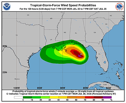

The National Hurricane Center in Miami issued its fifth forecast advisory for Tropical Depression Two on Monday afternoon, placing the storm’s center near 28.5 degrees north latitude and 85.6 degrees west longitude as of 3:00 p.m. UTC on July 20, 2026.
The depression was moving toward the northwest at just 3 knots — roughly 3.5 miles per hour — a very slow pace. The storm’s position is considered accurate within 30 nautical miles. Its minimum central pressure was recorded at 1007 millibars, with maximum sustained winds of 30 knots and gusts reaching up to 40 knots.
Looking ahead, forecasters expect the system to gradually strengthen over the next several days. By Tuesday morning, maximum winds are projected to reach 35 knots, climbing to 40 knots by Tuesday evening and 45 knots by Wednesday morning. The storm is expected to maintain that intensity through Wednesday afternoon before beginning to weaken slightly as it approaches and moves inland.
According to the forecast track, the depression is expected to move inland sometime around Wednesday night into Thursday morning, near the 29.5 degrees north, 90.8 degrees west area. After landfall, winds are forecast to ease to 35 knots by Thursday morning.
The extended outlook shows the system continuing inland, with winds dropping to 30 knots by Friday and further weakening to 25 knots by Saturday as it pushes deeper over land.
Forecasters noted that track errors on extended outlooks average around 125 nautical miles on day four and 175 nautical miles on day five, with intensity errors averaging about 15 knots per day. The next advisory was scheduled for 9:00 p.m. UTC Monday. The forecast was issued by forecaster Beven.