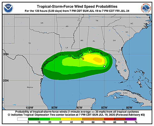

A tropical depression has officially formed in the northeastern Gulf of America, and forecasters at the National Hurricane Center in Miami are watching it closely as it slowly drifts toward the Florida Panhandle.
The system, designated Tropical Depression Two, was classified Sunday morning after developing a well-defined low-level circulation over the past several days. While convective activity — the storm-related thunderstorm clusters — remains uneven due to dry air pushing in from the northeast, there is enough persistent storm activity near the center and in surrounding bands to qualify it as a tropical depression. The circulation is described as large and still relatively weak.
Based on surface weather observations and earlier satellite wind data, the storm’s initial intensity has been set at 25 knots, or about 30 miles per hour, with a minimum central pressure of 1011 millibars. Air Force Hurricane Hunter aircraft are scheduled to fly into the system later Sunday to get a better picture of its structure.
Pinpointing the storm’s exact movement has been tricky since it only recently became well organized, but forecasters believe it is currently drifting north-northwestward at about 3 knots. The system is caught between competing weather features — a ridge over the western Atlantic, another ridge over the south-central and southwestern United States, and a trough over the northeastern U.S. — all of which are creating weak steering currents.
That pattern is expected to carry the depression slowly northwestward through Monday night, bringing it close enough to the Florida Panhandle to produce tropical storm conditions there. A Tropical Storm Watch has already been issued for that area. After that, forecasters expect the storm to turn westward or west-northwest as a ridge over the southern United States expands eastward, potentially pushing the system near or across the Gulf Coast during the middle and latter part of the week.
Strengthening is expected to be slow at first, given the storm’s sprawling structure, nearby dry air, and some northeasterly wind shear working against it. However, forecasters expect it to reach tropical storm status as it approaches the Florida Panhandle over the next day or two. There may be a better window for additional strengthening once the system turns westward, though how much it intensifies will depend heavily on how much time it spends over land versus open water.
The National Hurricane Center’s track forecast leans toward the upper end of available computer model guidance, though forecasters acknowledge there is low confidence in the forecast given uncertainty about how much land interaction the storm will experience.
Key Messages from the National Hurricane Center:
1. The depression is forecast to gradually strengthen and could bring tropical storm conditions to parts of the Florida Panhandle, where a Tropical Storm Watch is in effect.
2. Residents in Alabama, Mississippi, Louisiana, and Texas should monitor the storm’s progress, as watches may be needed for portions of those areas within the next day or two.
3. Flash flooding will be possible through Thursday along the eastern and central Gulf Coast, stretching from western Florida through southern Alabama, Mississippi, and Louisiana.
The forecast was issued by Forecaster Cangialosi at the National Hurricane Center.