The National Weather Service office in Mount Holly, New Jersey has issued an Extreme Heat Watch for the area, effective starting June 29th at 5:17 PM Eastern Time and running through July 4th at 8:00 PM Eastern Time.
An Extreme Heat Watch means that conditions are favorable for a dangerous heat event to develop in the coming days. Residents are urged to take the threat seriously, as extreme heat is one of the leading weather-related causes of illness and death.
Health officials typically recommend that people stay indoors during the hottest parts of the day, drink plenty of water even if not feeling thirsty, and never leave children or pets inside parked vehicles. Those without air conditioning are encouraged to visit cooling centers in their area.
Special attention should be given to elderly residents, young children, and those with chronic health conditions, as these groups are most vulnerable to heat-related illness. Neighbors are encouraged to check in on one another during the watch period.
The watch covers the Fourth of July holiday weekend, when many people are expected to be outdoors for celebrations. Residents planning outdoor activities should schedule them for early morning or evening hours when temperatures are lower, and take frequent breaks in the shade or air conditioning.
An Extreme Heat Watch has been issued by the National Weather Service office in Mount Holly, New Jersey, set to take effect on June 29th at 2:10 PM Eastern Time and running through July 4th at 8:00 PM Eastern Time.
The watch covers an extended stretch of the upcoming holiday weekend, raising concerns about dangerous heat conditions for residents across the area.
An Extreme Heat Watch means that conditions are favorable for a dangerous heat event in the coming days. Residents are encouraged to stay hydrated, limit outdoor activity during the hottest parts of the day, and seek air-conditioned spaces when possible.
Those most at risk during extreme heat events include the elderly, young children, outdoor workers, and individuals with certain medical conditions. Neighbors are urged to check on one another, particularly those who may be living alone or without access to air conditioning.
Stay with TV Delmarva for continuing updates on this developing weather situation as the July 4th holiday approaches.
An Extreme Heat Watch has been issued by the National Weather Service office in Mount Holly, New Jersey, set to remain in effect from the afternoon of June 29th through the evening of July 4th.
The watch period begins at 2:10 PM Eastern Time on June 29th and extends through 8:00 PM Eastern Time on Independence Day, covering what could be a dangerously hot holiday weekend.
Residents are encouraged to stay hydrated, limit time outdoors during peak afternoon hours, and check on elderly neighbors, young children, and pets. Extreme heat is one of the leading weather-related causes of illness and death, particularly for vulnerable populations.
More details and updates are expected as the event approaches. Stay with TV Delmarva for the latest on this developing weather situation.
DES MOINES, Iowa — A powerful heat wave that has been baking the Midwest since the start of the week is on the move, and the Eastern United States — including the Mid-Atlantic region — is next in line. Outdoor events have been scrapped or pushed back, cooling centers have been activated, and health officials are warning people to take the heat seriously.
“Overall, we’re looking at just a really hot and humid pattern. It’s going to be with us through most of the week,” said Andrew Ansorge, a meteorologist based in Des Moines, Iowa, describing what he called the first prolonged stretch of heat this summer.
Much of Iowa and large portions of the Midwest remained under an extreme heat warning through at least Tuesday. Actual air temperatures were expected to climb into the 90s, but the “feels-like” heat index — which accounts for humidity — was forecast to exceed 100 degrees Fahrenheit (37.8 degrees Celsius), according to Ansorge.
Early Monday morning, a couple from Rogers, Arkansas, Tom and Cindy Youngblood, both 67, were already out walking through an outdoor sculpture park in Des Moines, where the heat index had already hit 96 degrees Fahrenheit (35.5 degrees Celsius) by 6 a.m.
“The breeze is helpful,” said Tom Youngblood, as he and his wife ducked in and out of shaded spots along the path.
The couple had just returned from a camping trip in Wisconsin but decided to skip sleeping in their camper van Sunday night. “We did not want to camp last night because we knew it would be too hot,” Cindy Youngblood said.
The heat is expected to get even more intense as it shifts toward the Ohio Valley, the Mid-Atlantic, and the Northeast later in the week. Scott Kleebauer, a meteorologist with the Weather Prediction Center in College Park, Maryland, said the worst conditions are likely to arrive Thursday and Friday, with the possibility of record-high temperatures being broken in some areas.
Kleebauer stressed that people should stay hydrated and find access to shade and air conditioning. He also noted the timing is particularly tricky: “It just so happens to be coinciding with a time frame where a lot of people are away and a lot of people are going away for vacation” during the Fourth of July holiday week.
The heat wave is not just a U.S. problem. In Europe, temperature records have also been shattered, and France has reported numerous heat-related deaths.
Medical professionals are raising the alarm about how quickly heat can become dangerous. Dr. Roy Elrod, chief of staff at DMC Detroit Receiving Hospital, said people often let their guard down at the start of summer.
“You’re happy winter’s gone, you’re ready to enjoy the summer, you’ve just been aching for it,” Elrod said. “And so, I think we slip into kind of a position where we think it’s got to be OK.”
But that mindset can lead to serious injury. Elrod warned that heat-related illness can set in within minutes, especially for those who skip the basics — drinking enough water, wearing light clothing, staying out of the sun during peak hours, and limiting overall exposure.
“We’re just not always prepared for it and it just takes an incident that rattles you and shakes you up that you understand that it can get serious very quick,” he said.
Across the Midwest on Monday, summer camp schedules were reshuffled to keep kids out of the heat. A farmers market in Michigan and a drive-in theater in Minnesota both shut down for the day due to the dangerous temperatures. In Flint, Michigan, the city opened four cooling centers that are set to operate through Wednesday, with the possibility of extending that timeline if the heat lingers.
Meanwhile, the University of Wisconsin-Madison announced it would close 23 campus buildings to the public beginning Tuesday and limit access to 11 others. A broken water line at the university’s cooling plant earlier this month has significantly reduced air conditioning capacity across campus, forcing some summer classes to be relocated.
Cox Neck Road is closed between Nowland Lane and Clarks Corner Road due to downed wires, according to traffic officials.
Motorists traveling through the affected area are urged to find alternate routes and avoid the closure until further notice.
No information has been released regarding what caused the wires to come down or when the road is expected to reopen. Drivers should use caution and stay alert for updates as crews work to address the situation.
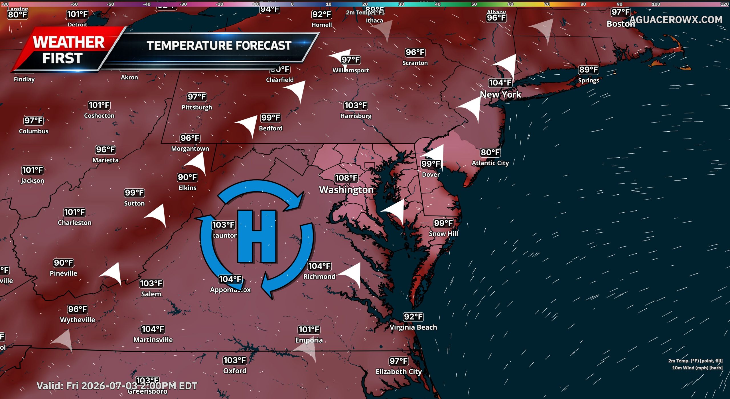
An extremely dangerous heat wave is expected to build across Delmarva and the Mid-Atlantic beginning Wednesday and lasting through the Fourth of July weekend, with the worst of the heat likely Thursday and Friday.
A strong ridge of high pressure will expand eastward from the Great Lakes and Ohio Valley into the Northeast and Mid-Atlantic by midweek. This setup will allow temperatures to surge well above normal, with highs reaching the mid and upper 90s Wednesday before climbing into the 100 to 105 degree range Thursday and Friday.
The combination of heat and humidity will create dangerous conditions for anyone spending time outdoors. Heat index values are expected to reach around 100 to 110 degrees Wednesday, then climb into the 110 to 120 degree range Thursday and Friday. Some locations could see heat index values near or above 115 degrees, especially where dew points remain higher during the afternoon.
This pattern could challenge daily and even all-time record high temperatures across parts of the region. For Georgetown, Delaware, the all-time record high is 104 degrees, set on July 22 and July 23, 2011. Forecast highs late this week may come close to that level, especially inland where a west to northwest wind could promote down sloping off the Appalachians and additional warming.
The hottest stretch is expected Thursday into Friday as winds shift more westerly to northwesterly. That flow should allow dew points to mix out somewhat during the afternoon, but the tradeoff will be even hotter air temperatures. Even if humidity drops slightly inland, the heat will remain dangerous.
Coastal areas may not be spared from the impacts. A sea breeze could hold actual temperatures down slightly near the beaches, but higher humidity could keep heat index values just as dangerous, especially during the afternoon and early evening.
An Extreme Heat Watch remains in effect for northern Delaware, New Jersey, southeast Pennsylvania, the Delaware Valley and the southern Poconos. Future updates could expand the watch to include more of Delmarva as confidence increases in the duration and severity of the heat.
Saturday will still be dangerously hot, even as the upper-level ridge begins to weaken and shift back toward the south and west. Highs are still expected to reach the mid 90s to near 100 degrees, with heat index values generally between 100 and 105 degrees. Locally higher values near 110 degrees remain possible where humidity does not mix out.
Relief will be slow to arrive. Temperatures should ease slightly by Sunday and Monday, but highs may still remain in the low to mid 90s with heat index values in the mid 90s to low 100s. That means heat-related impacts could continue beyond Saturday, especially for vulnerable groups and those without reliable cooling.
The pattern change may also bring increasing chances for showers and thunderstorms late Friday into the holiday weekend. Storm chances look higher Saturday and Sunday as the ridge breaks down and a trough tries to slide into the Northeast. Any storms that develop could briefly interrupt outdoor plans, but they may not provide widespread or lasting relief from the heat.
Residents should prepare now for a prolonged stretch of dangerous heat. Limit outdoor activity during the hottest part of the day, drink plenty of water, check on elderly neighbors and family members, never leave children or pets in vehicles and make sure pets have shade and water. Outdoor workers and anyone attending holiday events should take frequent breaks in air conditioning or shaded areas.
This type of heat can become dangerous quickly. Heat exhaustion and heat stroke are possible when the body cannot cool itself properly, especially during multi-day heat waves when overnight temperatures remain warm and recovery time is limited.
The National Weather Service office in Mount Holly, New Jersey has issued an Extreme Heat Watch, warning residents of potentially dangerous heat conditions expected to develop in the region.
The watch went into effect on June 29th at 2:46 AM Eastern Time and is set to remain active through July 4th at 8:00 PM Eastern Time — covering the entire Independence Day holiday weekend.
An Extreme Heat Watch means that conditions are favorable for a dangerous heat event to occur. Residents are urged to take precautions, stay hydrated, limit outdoor activity during the hottest parts of the day, and check on elderly neighbors, young children, and pets.
Those without access to air conditioning should identify cooling centers in their area ahead of the anticipated heat. Never leave people or animals in parked vehicles during extreme heat conditions.
TV Delmarva will continue to monitor this weather alert and bring you the latest updates as the holiday weekend approaches.
A dangerous stretch of extreme heat is forecast to blanket large portions of the United States this week and into the July 4th holiday weekend, according to the National Weather Service.
Meteorologists are pointing to a “heat dome” — a weather pattern that traps hot air over a region — as the driving force behind the hazardous conditions expected to affect millions of Americans in the coming days.
The National Weather Service has been tracking the developing heat threat as it spreads across significant portions of the country, raising concerns about public safety during one of the busiest holiday weekends of the summer.
Residents across affected areas are encouraged to stay hydrated, limit time outdoors during peak afternoon hours, and check on elderly neighbors and vulnerable family members as the dangerous heat moves in.
A lengthy and potentially dangerous stretch of extreme heat is expected to sweep across a large portion of the central and eastern United States this week, according to the National Weather Service. Temperatures are on the rise heading into the July Fourth holiday, and high humidity arriving alongside the heat will make conditions feel significantly worse than the thermometer alone suggests.
As of Sunday, parts of the country — particularly Phoenix, central Texas, and much of the Southwest — were already recording temperatures near 100 degrees Fahrenheit (38 degrees Celsius). The weather service also issued warnings about rapidly developing wildfire conditions across much of the West, where new fires were breaking out across the region.
More than 130 million Americans across southern and Great Plains states were already under moderate to severe heat risk conditions on Sunday, according to weather service maps. That affected area is expected to grow and intensify as the week continues.
Forecasters are predicting several consecutive days of extreme temperatures — some topping 100 degrees F — settling over the lower Great Lakes, the mid-Atlantic region, and the Mississippi and Ohio River valleys. Weather service meteorologist Bryan Putnam said some record high temperatures could be broken in areas stretching from the lower Great Lakes through the mid-Atlantic and into New England later in the week.
Several major cities may record their hottest temperatures of the year so far, even as they host World Cup matches and celebrations marking America’s 250th anniversary. East Coast cities including New York, Philadelphia, Washington, and Baltimore are expected to feel the brunt of the heat, along with Midwestern and Great Lakes cities such as Chicago, Indianapolis, St. Louis, and Detroit. Southern cities including Dallas, Little Rock, Arkansas, and Memphis, Tennessee, will also face dangerous heat conditions.
The heat is forecast to linger into next weekend across the Great Plains, the Southeast, and the mid-Atlantic, the weather service said. Temperatures are expected to climb well into the 90s and low 100s Fahrenheit, with heat indexes — which account for humidity — reaching between 100 and 110 degrees F (40 to 43 degrees Celsius), and potentially as high as 115 degrees F (46 degrees Celsius) in some locations.
Putnam stressed the broad danger this heat poses. “That’s heat that’s impactful to anyone,” he said. “It’s not just older adults or younger children or people who are spending a ton of time outdoors, maybe straining themselves a little more than normal. This is heat that really could impact everyone, especially with people outdoors going into the holiday weekend.”
AccuWeather meteorologist Tyler Roys noted that temperatures will run significantly above seasonal averages. In Washington, for example, temperatures around July Fourth typically average around 89 degrees F (32 degrees Celsius), while Indianapolis averages around 85 degrees F (29 degrees Celsius). This week, both cities are expected to run 10 to 11 degrees hotter than those averages, Roys said.
Roys described the high-pressure system driving the heat as acting like a “rock” that forces storms around it and cuts off rainfall across the East — a pattern sometimes referred to as a “heat dome.” Overnight temperatures dropping only into the 70s F or even the high 80s will offer little relief, meteorologists said.
For people without air conditioning, particularly in East Coast cities like New York where nighttime lows may not fall below 80 degrees F (27 degrees Celsius), Roys said sleeping will be miserable. He also warned that this is a prime time for heat-related illness, because the body has no opportunity to recover and cool down overnight.
The National Weather Service advises people to reduce outdoor activity during peak heat hours, drink plenty of water, and make sure they have access to air conditioning or other cooling locations.
Meanwhile, wildfire conditions remain severe across the West. Three firefighters working for the U.S. Wildland Fire Service and the U.S. Forest Service were killed near the Colorado-Utah border when fast-moving flames overtook them. Two other firefighters sustained burn injuries in the same incident. Wildfire activity has been intensifying across Utah, Colorado, Arizona, and other parts of the Western U.S. as hot, dry, and windy weather continues to fuel the blazes.
A significant heat alert is now in place after the National Weather Service office in Mount Holly, New Jersey issued an Extreme Heat Watch starting June 28th at 2:11 PM Eastern Time.
The watch remains in effect through the evening of July 4th, ending at 8:00 PM Eastern Time — covering nearly the entire Independence Day holiday weekend.
An Extreme Heat Watch means that conditions are favorable for a dangerous heat event in the coming days. Residents are urged to stay hydrated, limit time outdoors during peak afternoon hours, and check on elderly neighbors, young children, and pets who may be especially vulnerable to extreme heat.
If you do not have air conditioning at home, local cooling centers may be available in your area. Residents should monitor updated forecasts from the National Weather Service as the holiday weekend approaches.
France’s public health agency announced Sunday that the country experienced roughly 1,000 more deaths than usual last week during the peak of a record-shattering heat wave, even as other parts of Europe faced yet another day of broken temperature records, dangerous wildfires, and widespread heat-related suffering.
The extreme heat continued pushing eastward across the continent over the weekend, toppling temperature records in several nations along the way.
In Germany, a new nighttime temperature record was set Sunday in Kubschütz, located in eastern Saxony, where temperatures never fell below 29.4 degrees Celsius — that’s about 84.9 degrees Fahrenheit. That overnight record came just hours after a daytime record of 41.5 degrees Celsius, or 106.7 degrees Fahrenheit, was measured in Möckern-Drewitz in Saxony-Anhalt. Those figures came from preliminary data released by the German Weather Service, known as DWD. Remarkably, the previous record had only been set the day before.
A new study released Friday by the World Weather Attribution — a Europe-based scientific collaboration — concluded that the extreme heat and humidity gripping Europe this week simply could not have occurred without the influence of climate change. The rapid analysis found that conditions like these would have been virtually impossible just 50 years ago, and are now 200 times more likely than they were just two decades ago.
France’s national public health agency, Public Health France, reported that death tolls surged dramatically during the worst days of the heat wave. On Wednesday — when France endured its hottest temperatures ever recorded — more than 1,200 deaths were counted. That figure climbed to more than 1,400 deaths on each of the two days that followed. For context, France’s typical daily death rate during April and May, before the heat arrived, hovered between 900 and 1,000. The agency calculated that at least 1,000 deaths above normal occurred during those three days alone, and officials cautioned that number will likely grow as additional data — including deaths that occurred at home — is gathered.
The agency also noted a sharp rise in emergency calls to private residences, particularly in the Paris region. The deadliest impact was felt in areas that had been placed under red extreme heat warnings, which covered roughly three-quarters of France at the heat wave’s peak. Officials said that 85 percent of the deaths involved people aged 65 and older.
Germany also faced serious wildfire threats. In Gohrischheide in eastern Germany, a fire broke out in a large forest that remains contaminated with leftover ammunition from World War II, making the firefighting effort significantly more hazardous. A similar situation unfolded near the town of Traisen in southwestern Germany, where a forest fire ignited in an area containing unexploded ordnance. Firefighting operations had to be temporarily halted after explosions occurred, and a bomb disposal unit was brought in to continuously evaluate the danger, according to the German news agency dpa.
Meanwhile, city fire departments across Germany were overwhelmed with heat-related medical emergencies. Berlin alone saw 500 additional ambulance calls on Saturday, the vast majority of them tied to the heat.
Berlin police came up with an unusual way to bring some relief to residents and visitors. Officers deployed two large water cannons — equipment typically reserved for crowd control during protests — in front of the city’s famous Brandenburg Gate and sprayed cool water over cheering crowds gathered in the heat.
The extreme temperatures also took a toll on Germany’s transportation infrastructure. Concrete surfaces on highways cracked and buckled across the country, and the national rail operator Deutsche Bahn urged passengers to avoid non-essential train travel over the weekend. In the eastern city of Leipzig, tram service was suspended entirely until early Monday morning after the intense heat caused the sealant used in track joints and switches to melt and clump together throughout the city’s transit network, according to the Leipzig Public Transportation Authority.
Elsewhere in Europe, Greece’s Civil Protection agency issued a warning Sunday of a “very high fire risk” across five regions of the country. Wildfires are a persistent challenge in Greece given its dry, mountainous terrain and more than 100 inhabited islands. Authorities there have been exploring new space-based technology to help detect and combat fires more quickly.
In Denmark, which set new temperature records on Saturday, the extreme heat gave way to powerful thunderstorms. By Sunday morning, the country had recorded 1,156 lightning strikes, according to public broadcaster DR.
The National Weather Service office in Mount Holly, New Jersey has put an Extreme Heat Watch into effect for the region, and it covers a significant stretch of time heading into the holiday weekend.
The watch went into effect on June 28th at 3:57 in the morning and is set to remain active until 8:00 in the evening on July 4th.
An Extreme Heat Watch means that conditions are favorable for a dangerous heat event to develop in the coming days. Residents are urged to stay hydrated, limit time outdoors during the hottest parts of the day, and check on elderly neighbors, young children, and pets who may be especially vulnerable to extreme heat.
Stay with TV Delmarva for the latest updates on this heat watch as the Fourth of July holiday approaches.
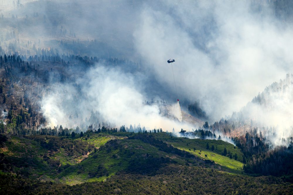
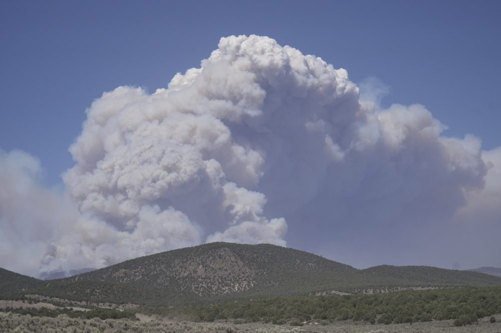
Wildfire activity is surging across the western United States as back-to-back days of scorching heat, parched conditions, and strong winds have fed fast-moving flames in Utah, Arizona, and beyond — with new fires continuing to break out throughout the region.
The biggest blaze, known as the Cottonwood Fire, is tearing through rugged terrain in southwest Utah. By Saturday, it had grown to more than 144 square miles — roughly 373 square kilometers — after sweeping through canyons and along steep mountainsides, taking out a portion of a ski resort and a number of summer cabins in its path.
Damage assessment teams in Beaver County began working alongside fire crews Saturday, though no specific damage figures were immediately released. Gov. Spencer Cox took to social media to describe the situation as grim, while also expressing gratitude to firefighting crews for what he described as “several miraculous stops and saves.”
The rugged landscape has made firefighting even more difficult. Alyssa Mason, a spokesperson assigned to the Cottonwood Fire, explained the challenges crews are facing on the ground.
“It’s hard to get dozers and other heavy equipment into that. It’s hard to get engines into that,” she said. “It doesn’t make it impossible to firefight, but it does just kind of slow things down.”
Hundreds of firefighters have been deployed across Utah to tackle both newly ignited blazes and fires that have continued to spread. Weather forecasters have described current conditions as critical fire weather — a combination of dangerously low humidity, warm temperatures, and strong gusts.
The threat is compounded this year by Utah’s record-low snowpack and its warmest winter ever recorded. According to the National Interagency Fire Center, much of the western United States is dealing with similar conditions.
On Saturday, firefighting crews from Alaska to Florida worked to contain dozens of active fires, including 36 classified as large and uncontained. Across the country, close to 3 million acres — approximately 1.2 million hectares — have burned since January 1, surpassing the 10-year average.
The severity of conditions in Utah prompted Gov. Spencer Cox to declare a state of emergency earlier this week, which also cleared the way for a statewide fireworks ban ahead of the July Fourth holiday. Officials say Utah is currently experiencing one of its worst wildfire seasons in recent memory, driven by historic drought.
State Forester Jamie Barnes said that over the past week, Utah has seen a sharp rise in new fire starts, with each one displaying unusual and unpredictable behavior — pushing the state’s wildland firefighting resources to their limits.
The National Weather Service has issued red flag warnings across a broad stretch of the West in recent days, covering areas from California through Arizona and New Mexico.
In Arizona, south of Grand Canyon National Park, a newly ignited wildfire was reported to be moving away from Grand Canyon Village and the nearby community of Tusayan as of Saturday. However, roughly 50 miles away, a separate fire led Coconino County authorities to order evacuations for residents near Kendrick Mountain.
Parts of northern Arizona lost power Saturday after the local utility initiated a precautionary shut-off to reduce wildfire risk. Such power shutoffs have grown more common across the West as fire danger has increased — typically used as a last resort after utility companies weigh wind speeds, available fuel, and terrain.
In Utah, Rocky Mountain Power also cut electricity to Beaver County and surrounding areas as extreme fire conditions continued to persist.
Drivers in Sussex County should be on alert this morning as foggy conditions have been observed across the area at varying levels of intensity.
Authorities are urging motorists to take extra care while behind the wheel until the fog clears. Reduced visibility can make driving significantly more dangerous, so slowing down and increasing following distances is strongly recommended.
Four people have lost their lives due to flooding triggered by powerful thunderstorms in Kentucky, with the state’s governor declaring a state of emergency on Saturday as more heavy rain was forecast to move through the region.
The National Weather Service had flash flood warnings active Saturday for portions of both Kentucky and Indiana. By late Saturday afternoon, the agency reported that between 4 and 10 inches of rain had already soaked parts of southwestern Indiana, with more precipitation still possible.
Gov. Andy Beshear’s office said some areas of Kentucky could see up to 7 inches of rain through late Saturday evening.
Beshear announced on social media that three of the deaths occurred in Madison County and one in Jackson County, all attributed to flooding.
“This is a serious flooding event, where teams have already had to conduct multiple water rescues from vehicles and homes across the commonwealth,” Beshear said in a statement. “As more heavy rain continues through late tonight, we need folks to remain alert and to avoid driving, especially after dark when there is limited visibility.”
The governor noted that Madison County had “significant roads underwater” and that search and rescue teams had been deployed to the area. He added that at least 12 state roads were “out of commission” due to flooding conditions.
In northwestern Kentucky, just outside Louisville, emergency management officials in Bullitt County called on residents along a rural road to evacuate as a precautionary measure after a landslide occurred at a dam embankment. Officials said the dam itself was holding and showed no signs of imminent failure.
The National Weather Service reported that the Bullitt County area had received approximately 3 inches of rain over the previous two days.
Crews battling what is currently the largest active wildfire in the country are facing an uphill battle as historic weather conditions fuel dangerous fire behavior in southern Utah.
The blaze, which is burning near Marysvale in southern Utah, has been driven by extreme weather, and conditions are not expected to improve anytime soon. Officials say the fire is likely to continue behaving erratically through the weekend.
Firefighters are working under what experts are calling critical fire weather — a combination of factors including dry conditions that make containing the massive blaze significantly more challenging.
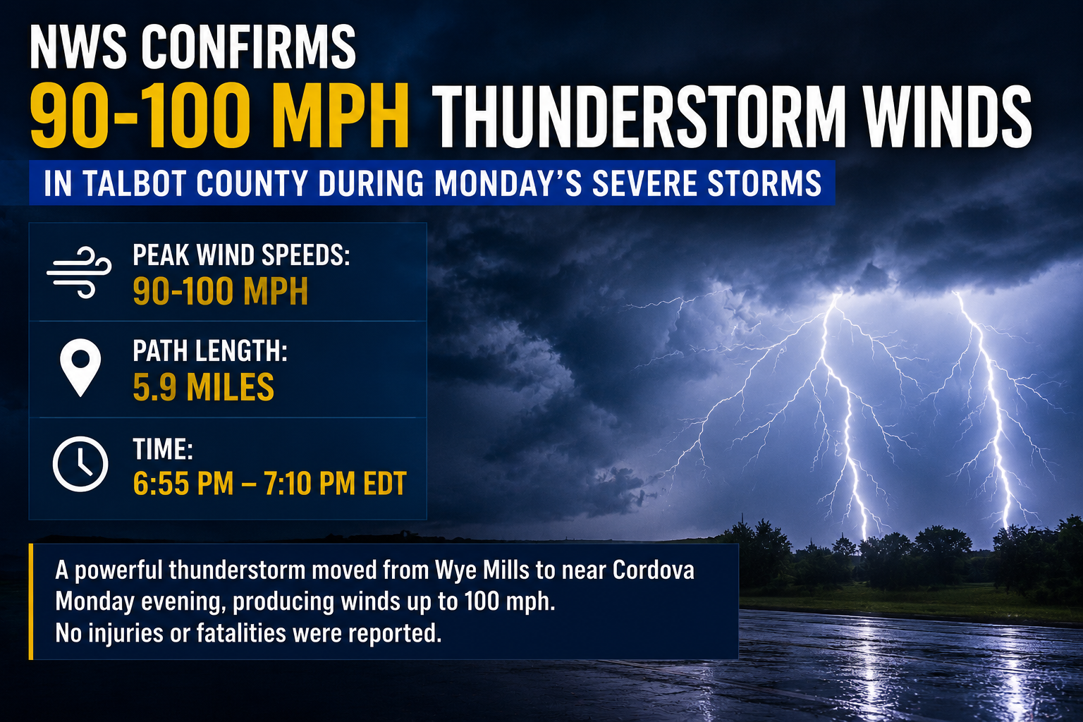
The National Weather Service out of Mount Holly, New Jersey issued a Severe Thunderstorm Warning on June 27, effective from 1:57 PM EDT through 2:30 PM EDT.
Residents in the affected area were advised to remain alert and take appropriate safety measures during the warning period. Severe thunderstorms can bring dangerous lightning, strong winds, and heavy rainfall in a short amount of time.
As always, people are encouraged to stay indoors, away from windows, and avoid travel during severe weather events. Monitor local forecasts for any updates or extensions to the warning.
The National Weather Service out of Mount Holly, New Jersey issued a Severe Thunderstorm Warning on June 27, beginning at 1:44 PM EDT and remaining in effect until 2:30 PM EDT.
Residents in the warned area are urged to seek shelter immediately, stay away from windows, and avoid outdoor activities until the warning has expired.
No additional details regarding storm location, movement, or specific hazards were included in the alert text. Check back for updates as conditions develop.
The National Weather Service office in Mount Holly, New Jersey issued a Severe Thunderstorm Warning on June 27, effective from 1:34 PM EDT through 2:00 PM EDT.
The warning was issued to alert residents in the affected area of dangerous thunderstorm conditions. Severe thunderstorms can bring damaging winds, large hail, and heavy rainfall in a short period of time.
Residents were advised to move indoors, stay away from windows, and avoid using electrical equipment during the storm. Those outdoors were urged to seek sturdy shelter immediately until the warning expired.
No additional details regarding specific storm impacts or damage reports were included in the original alert.
The National Weather Service office based in Mount Holly, New Jersey issued a Severe Thunderstorm Warning on June 27, effective from 1:10 PM EDT through 2:00 PM EDT.
The warning was put in place to alert residents in the covered area of dangerous thunderstorm conditions. Severe thunderstorms can bring damaging winds, large hail, and heavy rainfall in a short period of time.
Residents are always encouraged to stay indoors during severe thunderstorm warnings, avoid windows, and stay away from flood-prone areas. If driving, pull over safely and avoid flooded roadways.
The National Weather Service office in Mount Holly, New Jersey issued a Severe Thunderstorm Warning on June 27, beginning at 1:22 PM EDT and remaining in effect until 2:00 PM EDT.
Residents in the warned area are urged to move indoors, stay away from windows, and avoid unnecessary travel until the warning has expired. Severe thunderstorms can bring dangerous lightning, damaging winds, and heavy rain.
No additional details regarding the specific affected counties or storm characteristics were included in the original alert. Viewers should monitor local forecasts and official weather sources for the latest updates.
Motorists in the area should plan for a detour as St. Augustine Road is currently shut down between Farm Lane and West Market Street due to a tree that has fallen across the roadway.
The closure remains in effect while crews work to remove the downed tree and restore normal traffic flow. No timeline for reopening has been announced at this time.
Drivers are encouraged to use alternate routes and allow extra travel time until the road is cleared and reopened.
Motorists making their way northbound on Delaware Route 1 between Dewey Beach and Lewes should expect significant delays this afternoon.
According to traffic reports, heavy congestion along that corridor is causing backups of approximately 20 to 30 minutes for drivers traveling in that direction.
No specific cause beyond general traffic congestion has been cited for the delays. Drivers are advised to allow extra travel time or consider using alternate routes to avoid the slowdown.
European authorities are scrambling to respond to a powerful heat wave that has caused significant damage to transportation infrastructure, overwhelmed hospitals, and claimed lives across the continent.
In Germany, officials reported damage to major roadways and disruptions to rail service on Saturday as the intense heat — expected to peak at 40 degrees Celsius (104 degrees Fahrenheit) — pushed infrastructure to its limits. In two locations outside Berlin, sections of the concrete on the A2 highway cracked and buckled under the extreme temperatures, forcing authorities to close the road. Additional highway damage was reported elsewhere throughout the country, according to German daily Bild.
In the western city of Dormagen, dozens of nursing home residents had to be evacuated for medical treatment after temperatures inside the facility climbed to 35 degrees Celsius (95 degrees Fahrenheit). A resident at the home passed away overnight, though a city spokesperson told German news agency dpa that it remained unclear whether the heat was responsible.
Air conditioning is not common in Germany or much of Europe, as the region has historically not experienced such extreme summer heat.
Train operator Deutsche Bahn and other rail companies urged travelers to avoid all nonessential trips on long-distance and regional trains this weekend. “Germany’s transportation infrastructure is being severely affected by the record-breaking heat this weekend,” Deutsche Bahn said in a statement. The company added that passengers could return their tickets for a full refund if they chose not to travel.
Meanwhile, in France, the worst of the heat appeared to be easing in some areas, but hospitals continued to face enormous strain. In the capital, the Paris public hospital authority activated its emergency response plan across all 38 hospitals to manage a sharp rise in patients.
According to a statement released Friday evening, the hospital authority’s emergency departments treated nearly 3,000 patients in a single 24-hour period — more than a third above normal levels. A large share of those patients were over the age of 75 and required hospitalization. Calls to medical dispatch centers surged nearly 80% compared to the same period in 2025.
Three-quarters of France, home to tens of millions of people, were placed under a red alert for extreme heat on Thursday and Friday as temperatures topped 40 degrees Celsius (104 degrees Fahrenheit) in some areas, including Paris. The country also logged its hottest average day ever recorded on Wednesday, when the average temperature measured across 30 French weather stations hit 30 degrees Celsius (86 degrees Fahrenheit).
In the United Kingdom, the extreme heat was expected to gradually subside over the weekend, though an amber warning — one level below the most severe red alert — remained active through Saturday night. The country broke its June heat record three consecutive days in a row this week. Friday was confirmed as the hottest June day ever recorded in the UK, with a provisional high of 37.3 degrees Celsius (99 degrees Fahrenheit) measured in eastern England — more than one degree hotter than the previous June record set in the summer of 1976.
On Saturday, police reported that the body of a 22-year-old man was pulled from a river after he reportedly got into trouble in the water during the heat wave. Authorities across the region have cautioned people to use extra care when swimming in unsupervised locations such as rivers and lakes, following the deaths of approximately 40 people in France over the past week.
Japan was hit hard Saturday as two powerful tropical storm systems struck at the same time, bringing deadly landslides, rising floodwaters, and widespread damage, according to media reports and government officials.
The two storms, named Mekkhala and Higos, unleashed heavy rainfall across the country during Japan’s typical rainy season, washing out roads and creating hazardous conditions throughout the region.
In Yamaguchi Prefecture, a man in his 70s lost his life after a landslide caused a house to collapse on Friday. Three additional people sustained injuries in the same incident, according to Japan’s Kyodo News Agency.
News footage out of Kyoto captured the Kamo River surging with fast-moving, muddy water. Authorities issued flooding alerts for portions of Kyoto, Osaka, and several other communities across western Japan.
The country’s Fire and Disaster Management Agency reported that more than 30 homes were flooded in the Nara and Hiroshima areas on Friday. The severe weather also caused disruptions to train service and airline flights throughout the affected region.
PARIS — A devastating heatwave has gripped France this week, described as one of the worst ever recorded, pushing city residents to abandon their sweltering apartments and check into hotels in search of air conditioning and cooling pools.
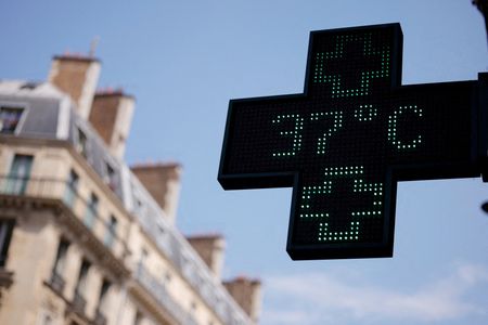
On Wednesday, temperatures in Paris climbed to 40.9 degrees Celsius — that’s nearly 106 degrees Fahrenheit — setting a new record for the month of June. This came just one day after France logged its hottest day since weather records began nearly 80 years ago.
The crisis has been made worse by the fact that very few private apartments in France are equipped with air conditioning, especially in the densely packed capital. Adding to the problem, roughly three-quarters of Paris rooftops are covered in zinc, a metal known for absorbing and retaining heat.
The result has been a surge in hotel bookings, both in major cities and in surrounding rural areas.
In the historic western French city of Tours, air-conditioned hotels were nearly completely booked earlier this week. Resident Veronique Savoye, who said the heat in her own home left her unable to think clearly, decided to check into a local hotel for a four-night stay running through Friday.
“It’s about being more comfortable, and — above all — being able to sleep,” she said.
Matthieu Evrard, CEO of hotel group Les Hotels (tres) Particuliers, described the demand as unlike anything he had seen before. “It is a quite extraordinary phenomenon. Every day, I have between five and ten people contacting me personally through various connections to get rooms in our hotels,” he said. “With the heatwave, everything has filled up in just two weeks.”
His group runs Les Maisons de Campagne, a countryside hotel brand with two properties located in the Yvelines department, about 45 minutes outside of Paris — the Chateau de Villiers-le-Mahieu, which sits within a 12-hectare park, and the Maison du Val in Saint-Germain-en-Laye.
Both properties are now completely booked, despite the fact that neither offers air conditioning. Instead, they rely on ceiling fans and the natural cooling effect of their thick stone walls. The appeal for Parisians, many of whom have children whose schools closed due to the heat, also includes outdoor pools and access to the surrounding countryside.
Savoye acknowledged that not everyone has the financial flexibility to book a hotel stay, but said she made the decision to put part of her vacation budget toward the room. “It was what you’d call a staycation. For me, it was worth it,” she said.
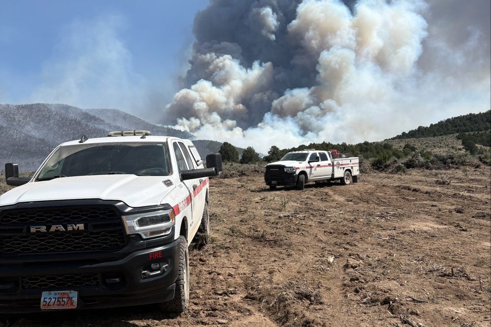
Scorching temperatures, bone-dry air, and powerful winds are driving a rapidly spreading wildfire in Utah, where the governor has declared a state of emergency and placed temporary restrictions on fireworks. The dangerous conditions across the western United States are raising alarms that even the smallest spark could trigger a disaster.
Fire crews on the ground are facing what fire managers and experts are calling unprecedented challenges. On Friday, aircraft including air tankers and helicopters had to be grounded as winds intensified over the Cottonwood Fire, currently the largest active wildfire in the country. Wind gusts reached 45 miles per hour and humidity dropped to single-digit levels, leaving firefighters with almost no tools to slow the blaze as it tore through the treetops.
“We are not expecting the weather to be kind to us for the next couple of days,” said Alyssa Mason, a spokesperson assigned to the fire. “We are seeing extreme fire behavior out there with some crown runs and definitely some spotting.”
Located in a lightly populated stretch of southern Utah, the Cottonwood Fire expanded Friday to more than 112 square miles. Among several major wildfires currently burning in Utah, it has severely damaged the Eagle Point ski resort in Beaver County and triggered evacuations in the area. In the nearby community of Marysvale, thick smoke blocked out the sun Friday while ash fell from the sky.
“We’re looking at a full 48 hours of critical weather that we have not seen in Utah in the last five years,” meteorologist Jason Straub told residents at a community meeting in Beaver County Friday evening.
Straub also warned that a cold front arriving Sunday could shift wind directions and push the fire into new territory before conditions begin to settle down next week.
Most of the smoke has been drifting eastward, which means air quality at well-known tourist destinations like Zion and Bryce Canyon national parks — both located well south of the fire — has not been severely impacted, though some haze has been reported near Bryce Canyon. The massive smoke plume, however, has been visible from great distances, reaching as far as Colorado.
Utah state forester Jamie Barnes said earlier this week that the situation is unlike anything seen in recent memory, acknowledging that fires are now spreading farther and faster “under conditions that defy historical expectations.”
Across the country, close to 3 million acres have burned since January, putting the nation ahead of the 10-year average. The National Interagency Fire Center reported that firefighters are working to contain fires stretching from Alaska all the way to Florida.
Low humidity and strong winds have triggered red flag warnings across a broad region running from Idaho down through southern Arizona and New Mexico. Wind forecasts in some areas call for gusts of 25 to 35 miles per hour, with the harshest conditions expected from northern Arizona through central and southern Utah.
At Grand Canyon National Park in Arizona, officials were bracing Saturday for a potential power outage. The local utility provider warned it would likely shut off electricity as a precautionary measure to reduce wildfire risk. Park visitors were advised to download maps and other key information ahead of their visit and to arrive with fully charged devices, since backup power systems may be limited.
Planned power shutoffs have become increasingly common across the West as wildfire danger has grown. Utility companies typically treat them as a last resort, weighing factors like wind speed, available fuel, and the lay of the land before making a decision. Rocky Mountain Power has issued a public safety power shutoff watch and warning for parts of central, southern, and eastern Utah through the weekend.
Tim Brown, a research professor and director of the Western Regional Climate Center, said extreme fire behavior will continue as long as the region stays hot, dry, and windy. He pointed to persistent drought conditions gripping Utah, Colorado, Arizona, and New Mexico as a major contributing factor.
“I would not be surprised to see a lot of restrictions come out as we get closer to the July Fourth weekend,” Brown said. “People really need to be aware of their surroundings if they’re going to be out in the forested campground areas and grassland areas.”
Gov. Spencer Cox has put fireworks restrictions in place through July 5, noting that “this year is different” as the country prepares to mark its 250th anniversary. Although the cause of the Cottonwood Fire has not been determined, the governor’s order pointed out that humans have been responsible for most of the wildfires in Utah so far this year.
Even in Florida, where multiple brush fires have broken out, officials are urging residents to forgo personal fireworks and leave the displays to professional, carefully organized shows.
Back at fire camp, spokesperson Mason described how Utah’s snowpack and stream flows peaked unusually early in March, creating what she described as extreme dryness across the region. That was followed by wind storms unlike anything previously recorded.
“If anything happens out there, any kind of spark hits fuels,” she said, “it is more than likely going to start a fire and more than likely going to get pretty big pretty quick.”
Heavy rainfall battered western Japan on Friday, causing flooding in multiple areas as two tropical storms moved toward the country on top of an already-active seasonal rain front.
According to the Japan Meteorological Agency, Tropical Storm Mekkhala was positioned off the western coast of Amami, a remote southern Japanese island, late Friday afternoon and was tracking northeast. A second storm, Higos, was traveling in close proximity to Mekkhala.
The JMA warned that both storms are expected to arrive in the Tokyo region by Saturday, bringing heavy rainfall with them.
Earlier Friday, a man was hurt after falling into a waterway in Nara, Japan’s NHK public television reported. Television cameras in Kyoto captured images of the Kamo River running high with murky, mud-filled water. Flooding alerts were put in place for portions of Kyoto, Osaka, and other communities throughout western Japan.
Japan’s Fire and Disaster Management Agency reported that more than 30 residences were flooded in Nara and Hiroshima on Friday. The severe weather also caused disruptions to train service and air travel in the affected areas.
Germans were preparing Saturday for dangerously hot conditions as a deadly heatwave sweeping across Western Europe was forecast to push eastward, with temperatures expected to climb close to 40 degrees Celsius — roughly 104 degrees Fahrenheit — in both Germany and Poland.
The heat system already baked Britain, France, and Switzerland in record-breaking June temperatures, and forecasters expected it to challenge more records as it crossed the Rhine River into Central Europe.
According to preliminary official data cited by German public broadcaster ARD, temperatures surpassed 41 degrees Celsius near Saarbruecken — on the border with France — on Friday, setting a new German record.
France has seen some of the worst impacts, with dozens of people — both young and elderly — losing their lives during the heat emergency. Temperatures exceeding 40 degrees Celsius there have thrown rail service into chaos, disrupted power generation, led authorities to ban alcohol sales, shut down schools, and forced the cancellation of outdoor gatherings.
Meteorologist Karsten Brandt of the weather forecasting site Donnerwetter.de warned that conditions would intensify before improving. “The heatwave is going to peak at the weekend, well over 40 degrees in some parts of Germany,” he said.
Even major sporting events have felt the impact. Organizers of the Ironman European Championship long-distance triathlon, scheduled for Sunday in Frankfurt, announced they were shortening both the cycling and running portions of the race because of the extreme heat.
Infrastructure is also under serious pressure. German national rail operator Deutsche Bahn announced it would allow customers to cancel long-distance travel bookings through early next week at no cost. The company noted that sun exposure, combined with the added threat of thunderstorms and wildfires, is putting significant strain on signals, rail tracks, and overhead wires.
Southwestern Germany has already experienced a far hotter June than is typical, and the most intense phase of the heat is expected to begin easing over the weekend, with heavy thunderstorms anticipated on Sunday.
Across Europe more broadly, the heatwave has forced historic cultural sites to close their doors, hurt agricultural production, and pushed some hospitals to their limits.
According to the Reuters Climate Monitor, temperatures have climbed as much as 18 degrees Celsius above seasonal norms. The extreme conditions are being driven by a weather phenomenon called an Omega block, which traps a large mass of hot air over a region for an extended period while pushing cooler air to the edges.
The surge in heat has sent demand for electric fans skyrocketing, while Asian air conditioning manufacturers reported a significant spike in European sales. Much of Northern Europe’s housing was designed to retain warmth rather than release it, making the heat particularly difficult to escape indoors.
The World Meteorological Organisation said the current heatwave will begin shifting toward Central Europe and the Balkans by the end of the month.
Scientists emphasized that this type of extreme heat event would have been nearly impossible without human-driven climate change, which they say has made this week’s nighttime temperatures roughly 100 times more likely than they were just two decades ago.
Thousands of residents across New Zealand were still without electricity on Saturday, one day after a powerful low-pressure system moved through the country, bringing with it severe flooding and dangerous landslides.
The utility company Powerco reported more than 3,000 power outages on Saturday following storms that struck central areas of the nation, which has a population of 5.3 million. The capital city of Wellington was among the hardest-hit areas.
The country’s national weather forecasting service, MetService, signaled that the worst had passed, writing on X: “After a very wet and windy 24 hours, the weather is on its way out.”
Despite improving conditions, emergency officials continued to urge caution, warning of debris scattered across roadways, pockets of surface flooding, and a lingering threat of landslides in and around Wellington.
The storm’s impact was felt beyond downed power lines. On Friday, approximately 200 flights were canceled at Wellington’s airport. Officials in Lower Hutt, a city located northeast of Wellington, reported flooded streets and confirmed two separate landslides in the area.
The severe weather serves as a grim reminder of past tragedies. Earlier this past January, heavy rainfall triggered a landslide at a popular campground on the country’s North Island, resulting in the deaths of six people.
Travelers making their way southbound along Coastal Highway are running into significant traffic congestion, with delays of approximately 10 to 15 minutes being reported between Lewes and Dewey Beach.
The slowdown appears to be the result of heavy congestion along that corridor. No specific incident or crash has been cited as the cause — the backup is attributed to traffic volume alone.
Drivers in the area are encouraged to allow extra travel time or consider alternate routes to avoid the delay.
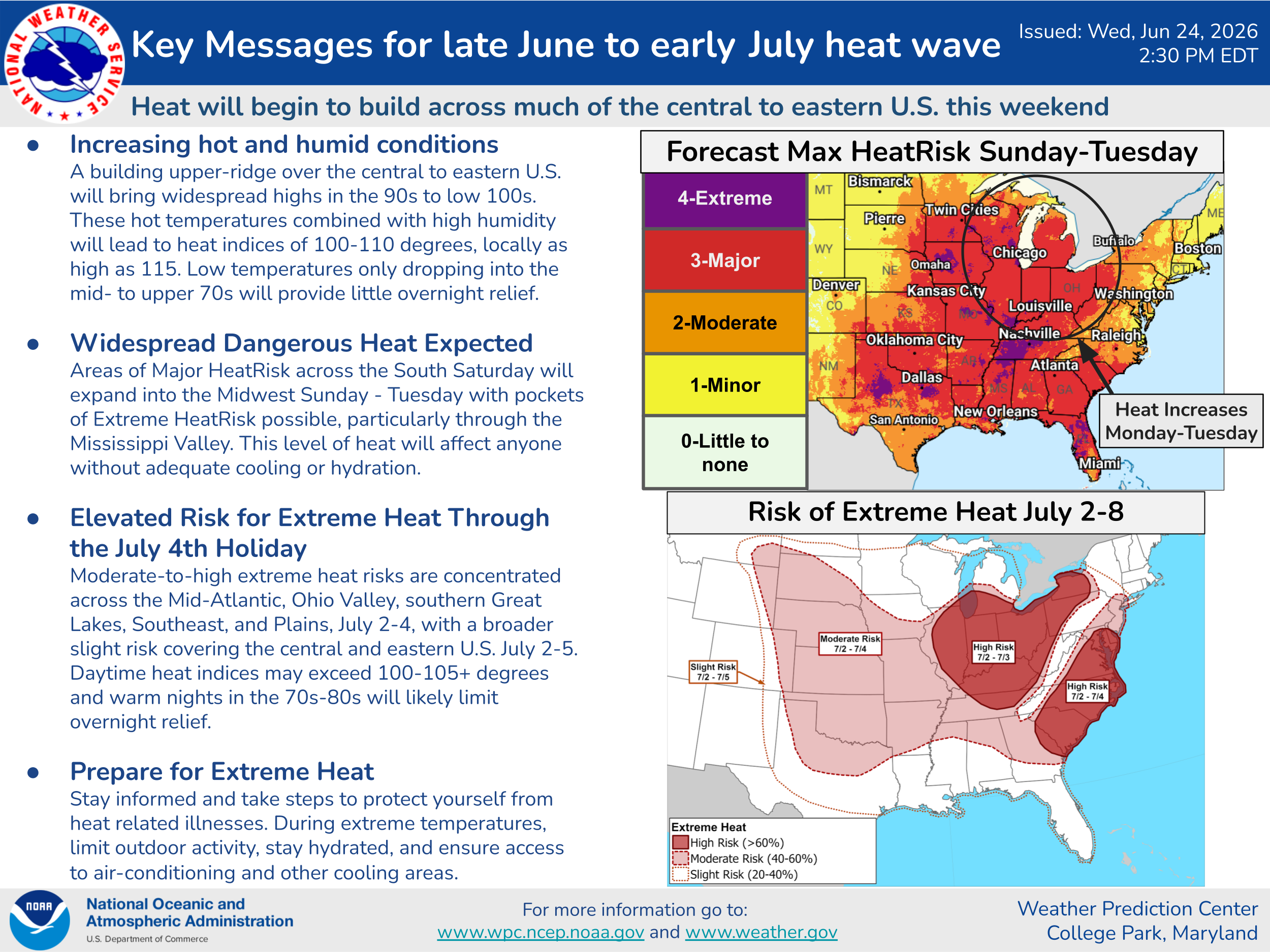
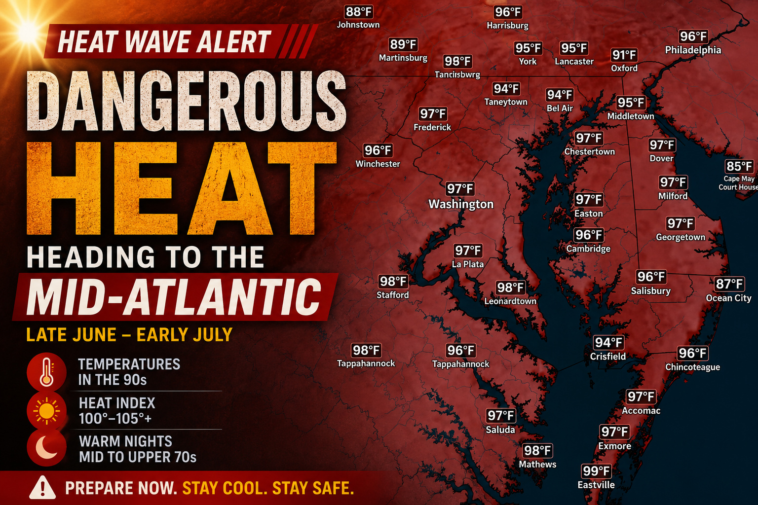
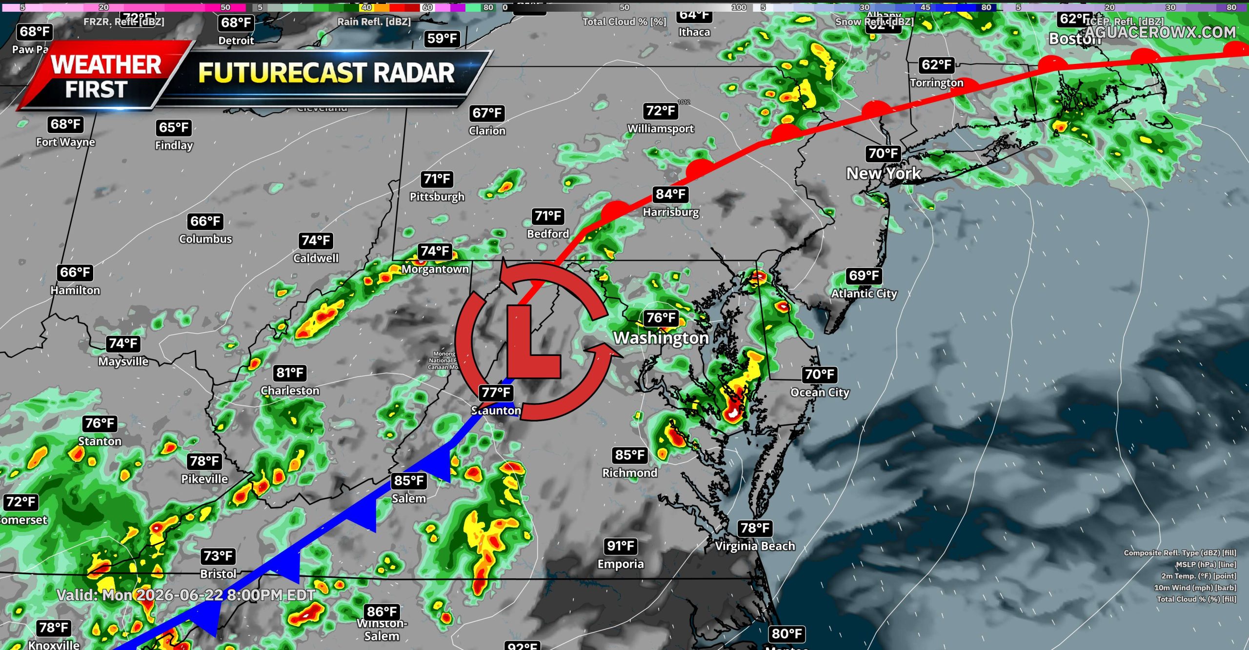
DELMARVA — A dangerous heat wave is expected to build across the region next week as a strong upper-level ridge, or heat dome, expands across the central and eastern United States.
Forecast guidance shows this ridge strengthening over the Ohio Valley, Mid-Atlantic and Southeast, allowing heat and humidity to surge into Delmarva. The hottest stretch looks likely from the middle of next week into the July 4th holiday weekend.
Afternoon temperatures could climb well into the 90s, with some inland areas approaching the upper 90s. When combined with high humidity, heat index values may reach 100 to 110 degrees at times, especially away from the immediate beaches.
This heat wave may last several days, making it more impactful than a short burst of summer heat. Overnight lows may only fall into the 70s, providing limited relief and increasing the risk for heat-related illness.
The Weather Prediction Center highlights a broad area of Major to Extreme HeatRisk across much of the eastern U.S. next week, while longer range outlooks continue to show an elevated risk for extreme heat through the July 4th holiday period.
Residents should begin preparing now by staying hydrated, limiting strenuous outdoor activity during the hottest part of the day, checking on vulnerable family members and neighbors, and making sure cooling options are available.
With outdoor plans, beach trips and July 4th events expected across Delmarva, heat safety will be especially important. Forecast details will continue to be refined, but confidence is increasing that a prolonged and dangerous stretch of heat is on the way.
With the Fourth of July approaching and America preparing to mark its 250th birthday, Utah’s governor declared a state of emergency Friday and placed temporary restrictions on fireworks — a response to the nation’s largest wildfire, which continues to burn completely out of control.
The Cottonwood Fire, which ignited Monday in a lightly populated stretch of southern Utah, had grown to nearly 111 square miles (287 square kilometers) by Friday with zero containment reported by forestry officials. It is one of six major wildfires currently burning across Utah. The blaze has caused serious damage to the Eagle Point ski resort in Beaver County and triggered mandatory evacuation orders for nearby residents.
Bruce Brown, 76, joined the local sheriff on Thursday to survey the damage, only to discover that his cabin — which he had owned for 31 years — and others nearby had been completely destroyed.
“It looks a lot like the moon,” he said. “Just burned out. Power poles tipped over all up the canyon.”
Alyssa Olsen, 27, also lost her family’s cabin in the fire. The structure held a room full of keepsakes from her grandfather’s days on the ski patrol. It was also the last place her family had gathered for photos with her grandmother before she passed away from cancer — and her brother had planned to get married there in just two months.
“That stuff you can’t just build back,” Olsen said.
Smoke from the fire has been drifting east and northeast, leaving popular tourist destinations like Zion and Bryce Canyon national parks — located well south of the fire — largely unaffected beyond some haze near the Bryce area. Even so, visitors have shared videos on social media capturing the massive smoke plume visible in the distance. The smoke has traveled hundreds of miles, reaching as far as Colorado.
“This is unlike anything we’ve seen in recent memory,” state forester Jamie Barnes said in a statement Thursday. “We’re seeing fires spread farther and faster under conditions that defy historical expectations. Some of the fires we’ve responded to this year are behaving in ways veteran firefighters simply haven’t seen before.”
Much of Utah is gripped by severe to extreme drought conditions, and parts of Arizona and Colorado are also experiencing severe drought, according to the U.S. Drought Monitor.
Gov. Spencer Cox put the fireworks restrictions in place through July 5, saying “this year is different.” His order gives state forester Barnes the authority to restrict or ban fireworks displays in Utah cities and towns, rather than leaving those calls to local communities.
The National Weather Service office in Salt Lake City issued a “Particularly Dangerous Situation” warning — the first time in the office’s history it has done so — covering five Utah counties, including the area where the Cottonwood Fire is burning. That designation was originally created to alert the public to tornado conditions. A red flag warning was also issued for most of the state, with the service urging residents to “prepare now for rapid fire growth.”
A similar warning had been issued ahead of the 2025 Palisades Fire in Los Angeles, which killed 12 people and destroyed thousands of homes across Pacific Palisades and Malibu. In a related development Friday, a federal judge declared a mistrial in the arson case against Jonathan Rinderknecht, the man accused of starting that fire, after the jury was unable to reach a verdict.
Extreme fire weather was forecast for Utah on Friday, with wind gusts reaching up to 50 mph (80 kph) and very low humidity levels across the southwest desert and central and southern mountain areas, including the Cottonwood Fire zone.
Rocky Mountain Power issued a public safety power shut-off watch and warning for parts of central, southern, and eastern Utah from Friday through the weekend.
Beaver County, where the Cottonwood Fire is burning, is home to roughly 7,400 people, according to the U.S. Census.
Separately, the Iron Fire — located about 70 miles (113 kilometers) southwest of Salt Lake City — had burned through 63 square miles (163 square kilometers) by Friday and was 26% contained. That fire had forced the evacuation of Eureka, a town of about 1,000 residents, along with people at a nearby ranch. Those residents were allowed to return Thursday.
While investigators have not determined what started the Cottonwood Fire, Gov. Cox’s emergency order noted that more than 75% of Utah’s wildfires this season have been caused by human activity.
Red flag warnings stretched across a wide portion of the western United States on Friday — from Idaho down through southern Arizona and New Mexico — indicating that low humidity, warm temperatures, and strong winds were creating extreme wildfire risk. Those warnings were expected to continue into Saturday, with winds of 25 to 35 mph (40 to 56 km/h) and very low humidity. The most dangerous conditions were forecast from northern Arizona into central and southern Utah.
In New Mexico, firefighters were working to contain a wildfire that forced evacuations at campgrounds and a YMCA camp in the Jemez Mountains. In Arizona, a separate fire near Sedona prompted evacuations last weekend, burning several hundred acres of steep, rugged terrain near Oak Creek Canyon.
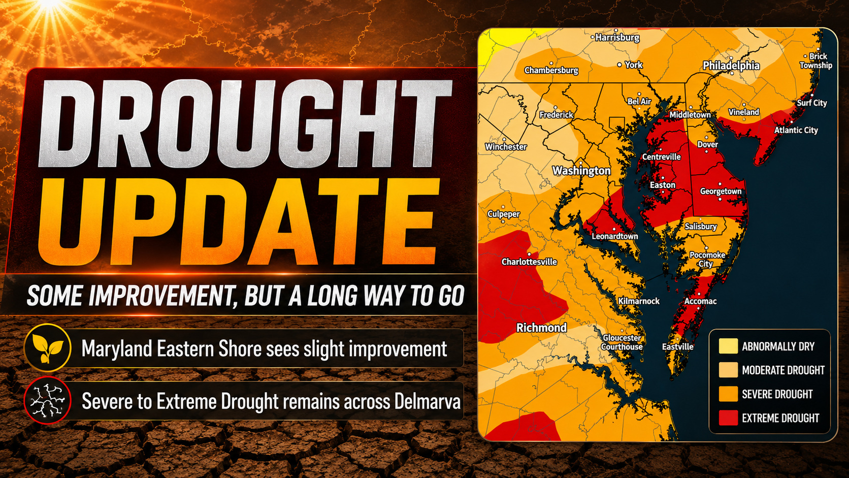
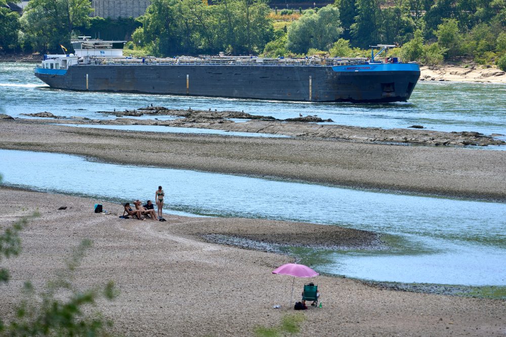
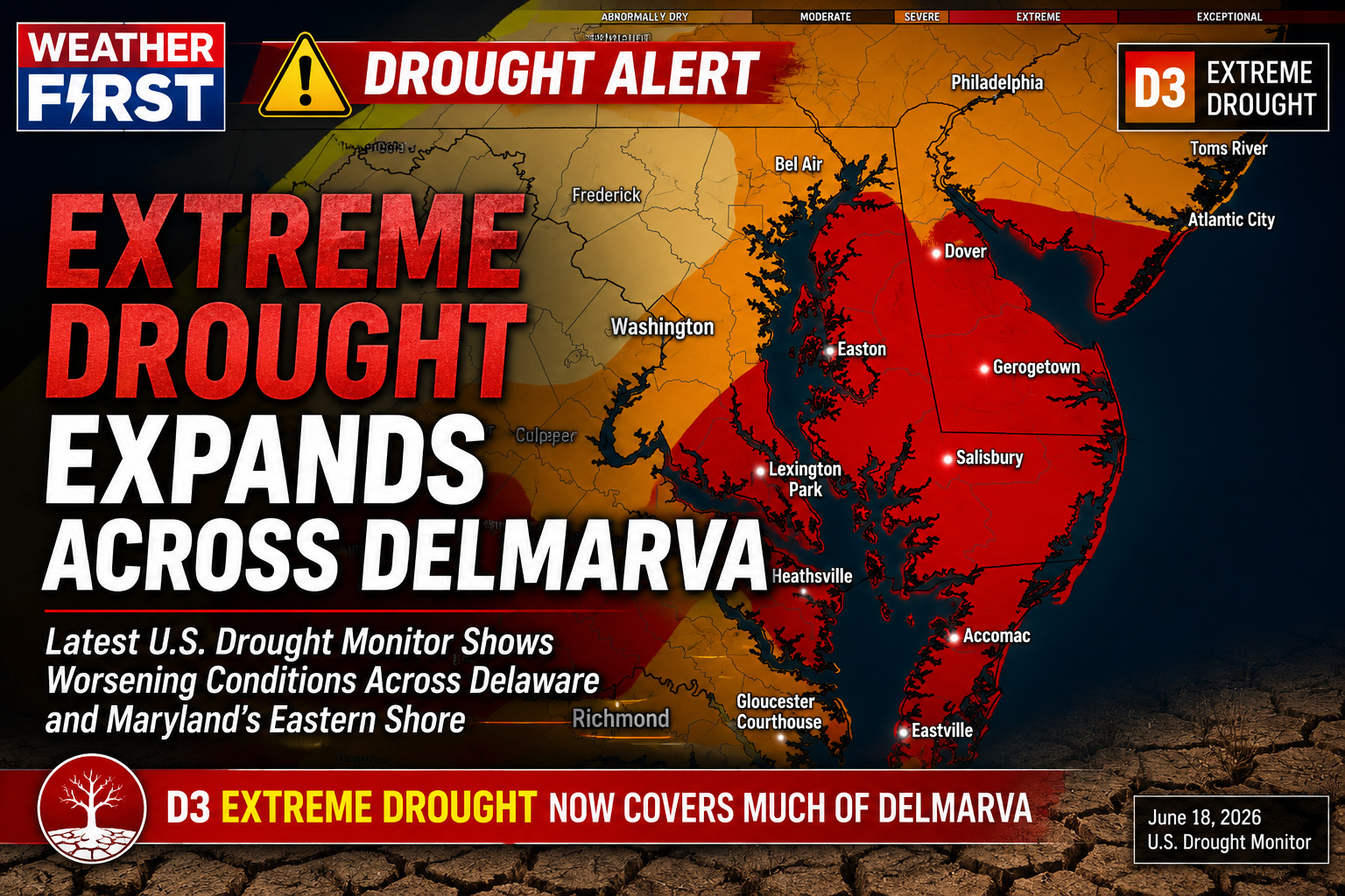
DELMARVA — The latest update from the U.S. Drought Monitor shows some improvement across portions of the Maryland Eastern Shore, but the region remains locked in a significant drought pattern with severe to extreme drought still covering much of Delmarva.
The newest drought map shows the most serious conditions remain focused across Delaware, the central and upper Maryland Eastern Shore, far southern New Jersey, and portions of the lower Eastern Shore into Virginia’s Eastern Shore. Areas shaded in red remain in Extreme Drought, while orange indicates Severe Drought.
The U.S. Drought Monitor is produced weekly by NOAA, USDA and the National Drought Mitigation Center, using categories from D0, Abnormally Dry, through D4, Exceptional Drought.
For Maryland as a whole, drought remains widespread. Drought.gov lists 92.3% of Maryland in drought, with 54.2% in Severe Drought and 22.7% in Extreme Drought. The national drought summary also notes ongoing short-term and long-term precipitation deficits across parts of Maryland, with year-to-date deficits of more than 5 inches reported in several locations.
On Delmarva, the improvement this week appears most noticeable across parts of the lower Maryland Eastern Shore, where some areas have been reduced from extreme drought into severe drought. That is a step in the right direction, but it does not erase the longer-term rainfall deficits that have built up over the past several months.
Delaware continues to be one of the hardest-hit areas locally. Drought.gov lists 100% of Delaware in drought, with 34.9% in Severe Drought and 65.1% in Extreme Drought. Sussex County remains fully affected by drought, with the county ranking as the 7th driest year-to-date over the past 132 years from January through May 2026. Kent County also remains fully affected, ranking as the 4th driest year-to-date over the same 132-year period.
Recent showers and thunderstorms have helped in spots, especially where heavier rainfall occurred, but much of the rain has been uneven. That means one town may see temporary relief while another nearby area remains very dry. For drought recovery, the region needs repeated rounds of steady, soaking rainfall rather than brief downpours that quickly run off.
The concern going forward is the building heat expected into late June and early July. The latest national drought summary notes that hotter-than-normal weather is expected from the Plains to the Atlantic Coast heading into the June 30 through July 4 period. Higher temperatures, increasing humidity and stronger evaporation rates can quickly offset short-term rainfall gains, especially across farmland, lawns, gardens and shallow-rooted vegetation.
While the Maryland Eastern Shore did see some improvement this past week, the message remains clear: Delmarva still has a long way to go. Severe to extreme drought remains firmly in place across much of the peninsula, and it will take a more sustained wet pattern to bring meaningful, long-term relief.
DELMARVA – After a relatively seasonable stretch to end this week and through the weekend, confidence is increasing that a significant surge of heat will arrive across the Mid-Atlantic by the middle of next week, bringing the potential for dangerous heat and humidity to the Delmarva Peninsula.
Forecast guidance continues to show a strong upper-level ridge expanding eastward from the Plains and Great Lakes into the Mid-Atlantic by Wednesday. This pattern will allow temperatures to climb steadily while humidity increases, pushing heat index values into the 100‘s during the second half of next week.
While exact temperatures will become clearer over the coming days, the overall signal for a prolonged period of above-normal warmth continues to strengthen.
The National Weather Service’s latest long-range outlook highlights a broad area of Major HeatRisk expanding across much of the eastern United States from Sunday through Tuesday, with the threat lingering into early July. Additional outlooks indicate an elevated risk for excessive heat extending through the Independence Day holiday period across much of the eastern U.S.
For Delmarva, the hottest stretch currently appears to begin around Wednesday and continue into next weekend, when afternoon temperatures climbing well into the 90s, combined with increasing humidity, could produce heat index values exceeding 100 degrees.
Unlike short-lived hot spells, this pattern may also feature warm overnight lows in the 70s, limiting overnight cooling and increasing the cumulative stress on the body over several consecutive days.
Although this is still several days away and forecast details will continue to be refined, confidence is increasing that the region will experience its most significant stretch of heat so far this summer.
Residents should begin preparing now by:
Staying well hydrated.
Limiting strenuous outdoor activities during the hottest part of the afternoon.
Checking on elderly family members, neighbors, and those without reliable air conditioning.
Never leaving children or pets inside parked vehicles.
Planning outdoor work or recreation for the morning or evening hours whenever possible.
We will continue monitoring the strength and duration of the developing heat dome over the coming days. If current trends continue, heat-related advisories or warnings may become necessary for portions of the Mid-Atlantic next week.
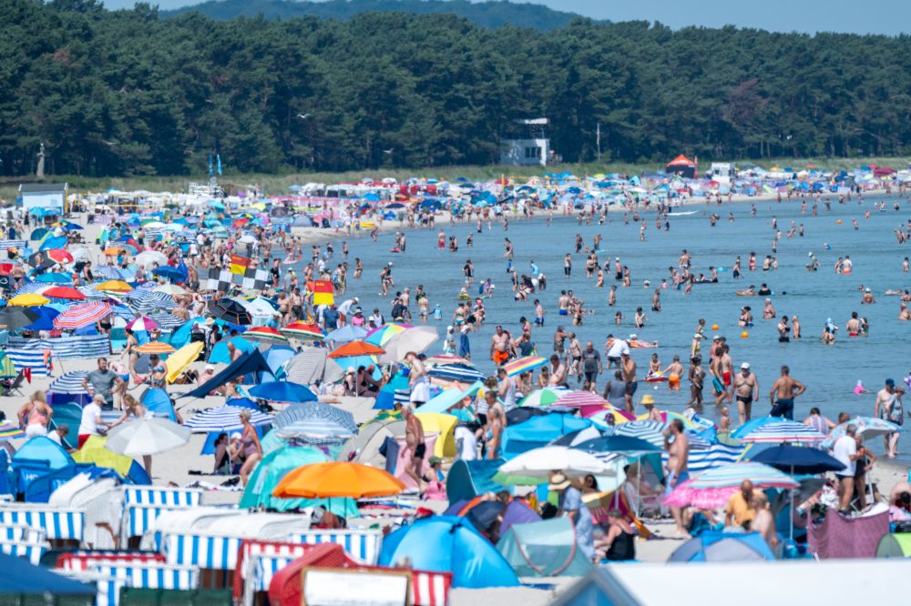
LONDON (AP) — A suffocating heat dome has settled over much of western Europe this week, sending temperatures climbing above 40 degrees Celsius — that’s 104 degrees Fahrenheit — across numerous locations.
What makes this event particularly notable is that it’s happening in June, well ahead of the traditional peak of summer. Both daytime highs and overnight lows are shattering previous records. High humidity levels are adding a tropical feel to a region normally known for its mild, temperate climate.
The scorching air is originating in north Africa, pushing northward through Spain and France before reaching countries like the United Kingdom, Belgium, and the Netherlands — nations that simply aren’t built or prepared for this level of heat.
Forecasters say conditions should ease slightly in the days ahead, but not before more records potentially fall. And with July and August — historically Europe’s hottest months — still on the calendar, this could be just the beginning.
Here’s a look at the key numbers telling the story of this extraordinary heat event:
23.5 — High humidity is making the heat especially miserable by preventing the body from cooling itself through sweating. This is a serious overnight problem in countries like the U.K., where air conditioning is uncommon. The Met Office, the U.K.’s national weather agency, confirmed that the country’s highest June overnight low temperature of 23.5 C (73.4 F) was recorded at Bute Park in Cardiff. In England, temperatures in Plymouth only dipped to 23.0 C (73.4 F), provisionally setting a new English record for the warmest June night.
26.2 — Germany experienced even more stifling overnight heat, tying its record for the warmest night on record. The German Weather Service reported that temperatures in Bad Bergzabern, located in the Rhineland-Palatinate region in western Germany, never dropped below 26.2 C. That matches a record set back in July 2019.
30 — France has arguably suffered the most, with three-quarters of the country under a red alert through at least Friday. On Wednesday, France logged its hottest day in recorded history. The Meteo France weather agency reported that the national thermal indicator — an average drawn from 30 weather stations across the country — reached 30 C (86 F) for the very first time. That mark could fall again on Thursday, with forecasters predicting highs of 40 to 42 C (104 to 108 F) in several areas.
31 — Formula 1 officials have designated the upcoming Austrian Grand Prix a “heat hazard,” with temperatures expected to exceed 31 C (87.8 F) on race day Sunday. That threshold triggers a requirement for drivers to carry additional cooling equipment. It will mark the first time these regulations — introduced just one year ago — have been applied to a European F1 race.
36.1 — The United Kingdom set a new record for its hottest June day, with 36.1 C (96.9 F) measured at Gosport in southern England. That record is widely expected to be surpassed in the coming days, as the Met Office has expanded its red heat alert to cover much of central and southern England, as well as Wales.
43.7 — Spain, along with perhaps Greece, is one of Europe’s most heat-hardened nations. Yet even Spain is feeling the strain. An all-time national record of 43.7 C (110 F) was recorded earlier this week in the village of Tama, located in the Cantabrian region — an area typically known for its cooler temperatures and lush, green scenery along the Atlantic coast.
1887 — Ireland’s all-time temperature record could come under threat on Thursday, according to Met Éireann meteorologist Gerry Murphy. The Republic of Ireland’s hottest temperature ever recorded was 33.3 C (91.9 F), set at Kilkenny Castle on June 26, 1887.
Residents across large portions of Western Europe were urged Thursday to take the ongoing deadly heatwave seriously, as the extreme temperatures continued to claim lives, disrupt transportation, and force the closure of schools and cultural sites.
Paris endured another brutally hot day following a record-breaking Wednesday, when the French capital recorded a June high of 40.9 degrees Celsius — equivalent to 105.6 degrees Fahrenheit. Across the English Channel, southern England also set a new June temperature record on Wednesday, reaching 36.1 degrees Celsius.
The mayor of Paris warned that the people most at risk may not be who residents expect. Speaking on broadcaster TF1, Emmanuel Gregoire said the most vulnerable populations are actually being watched closely and are well-informed about the dangers. Instead, he expressed concern about a different group.
“The profile of people currently facing health risks is not necessarily what one might expect — that is, the most vulnerable, because they are closely monitored and well informed,” Gregoire said. “Rather, it’s people aged between 50 and 70 who are generally in good health, but who think this is just a normal period and continue going about their usual activities as if nothing has changed. Really, protect yourselves.”
French authorities reported that at least 48 people have drowned since the heatwave began, many of them trying to find relief from the heat in bodies of water. Two young children also died after being left in a hot vehicle.
France has had protective measures in place since a devastating 2003 heatwave that caused nearly 15,000 excess deaths, with elderly citizens bearing the greatest burden. Those measures include regular check-ins on older residents and providing air-conditioned spaces for people in retirement homes.
Air conditioning is still relatively uncommon across Europe, but manufacturers from Asia — including South Korea’s Samsung Electronics, China’s Midea, and Japan’s Mitsubishi Electric — are seeing a surge in sales, particularly in France, Spain, and Italy.
Meteorologists say the heat is being driven by a weather phenomenon called an Omega block, named for its resemblance to the Greek letter Omega. The pattern features a bulging center that traps heat over a region for extended stretches, while cooler air remains at its edges. According to the Reuters Climate Monitor, the Omega block has pushed temperatures as much as 18 degrees Celsius above normal. Scientists note that climate change is intensifying both heatwaves and storms.
In Italy, the health minister called an emergency meeting after Italian media reported five heat-related deaths on Wednesday alone. The victims included two farmers in the northern provinces of Lodi and Piacenza, a man at a cemetery in the northern town of Pavia, a worker in the northeastern city of Padua, and a homeless man in the southern city of Naples.
France’s national weather agency offered some relief, saying temperatures there are expected to gradually drop beginning Friday. However, Germany, Austria, and Italy are bracing for a rough weekend ahead.
Germany’s National Meteorological Service issued extreme heat warnings for a broad swath of western Germany, where temperatures are forecast to climb to 38 degrees Celsius on Thursday, then reach 41 degrees Celsius on Friday and Saturday. The country’s national rail operator, Deutsche Bahn, announced that customers may cancel their travel plans without penalty due to the heat.
In neighboring Austria, weather officials issued a red heat warning for the northeastern part of the country, including the capital Vienna, where temperatures this weekend could potentially hit a record 40 degrees Celsius.
Italy faces its most intense heat between Saturday and Monday, with forecasts calling for temperatures up to 40 degrees Celsius — well above what is typical for this time of year — especially across northern plains and interior central regions.
A test tsunami warning was issued by the National Weather Service National Tsunami Warning Center on June 24, running from 12:30 PM EDT through 1:30 PM EDT.
This alert was a test message only and did not represent an actual tsunami threat or emergency situation.
A prolonged stretch of dangerous heat appears increasingly likely across the Mid-Atlantic beginning this weekend and continuing into the first week of July as a strong upper-level ridge builds over the eastern United States.
Forecast guidance indicates temperatures will climb well into the 90s across much of the region, while high humidity levels push heat index values above 100 degrees. Some locations could experience heat indices between 100 and 105 degrees, with isolated areas approaching 110 degrees during the hottest afternoons.
The greatest concern may be the lack of overnight relief. Overnight lows are expected to remain in the mid to upper 70s, allowing heat stress to accumulate over several consecutive days.
Long-range outlooks from the Climate Prediction Center continue to show a strong signal for above-normal temperatures across the Mid-Atlantic through at least July 7. Meanwhile, the Weather Prediction Center’s Extreme Heat Outlook highlights much of the region for a moderate to high risk of dangerous heat during the July 1-7 period.
Major cities such as Washington, Baltimore, Philadelphia, and surrounding communities could see multiple days of oppressive heat and humidity. Delmarva is also expected to be impacted, with temperatures likely running well above seasonal averages heading into the Independence Day holiday.
With confidence growing in a prolonged heat event, residents are encouraged to begin preparing now by staying hydrated, limiting outdoor activities during peak heating hours, and ensuring access to air conditioning or other cooling options.
While specific temperature forecasts will continue to be refined over the coming days, all signs point toward one of the hottest stretches of weather so far this summer across the Mid-Atlantic.
Utah is currently battling at least six active wildfires, and state officials say they are gearing up for what could be a prolonged and difficult fire season ahead.
The outbreak of fires across the state, sometimes called the Beehive State, has already taken a serious toll on at least one community. One of the blazes forced an entire town to evacuate, with residents unable to return home for nearly a week.
Authorities are monitoring the situation closely as conditions continue to raise concerns about additional fire activity in the weeks and months to come.
Emergency crews in northern France were working around the clock Wednesday to get the lights back on for thousands of households left without electricity during a punishing heatwave that has baked much of western Europe for several days.
Officials said a transformer failure was responsible for Tuesday’s outages, and that healthcare facilities and other critical locations were being given top priority in the restoration effort. Retirement homes were provided with generators to help them get through the crisis.
“The incident was accidental and related to the current heat wave,” officials stated. “No one was injured.”
According to the Reuters Climate Monitor, temperatures across Europe have soared as much as 18 degrees Celsius — or 32 degrees Fahrenheit — above normal levels, causing school closures, tourist site shutdowns, and widespread disruptions to transportation networks.
Weather agency Meteo France has drawn comparisons between the current conditions and a catastrophic heatwave in August 2003 that stretched 16 days and was linked to an estimated 80,000 excess deaths throughout Europe.
The current heat event is being driven by a weather pattern called an Omega block — named for its shape — which allows temperatures to climb steadily day after day. It remains unclear how long the dangerous conditions will persist.
The World Meteorological Organisation has noted that Europe is warming at more than double the global average rate, making extended periods of extreme heat increasingly common.
The scorching conditions have forced construction workers to shift their schedules to avoid peak heat hours. Retailers are struggling to keep up with surging demand for fans and portable air conditioners, and farmers have been harvesting grain at night after afternoon fieldwork was banned due to the risk of fires.
Dozens of people have drowned after jumping into rivers, lakes, and other bodies of water in an attempt to cool off.
Across the English Channel in Britain, the national grid operator called on power generators to boost output as temperatures climbed toward record levels Wednesday. With thermometers hitting the high thirties, British health authorities issued a “red heat” alert — only the second time such a warning has ever been declared — cautioning that the heat poses a risk to life even for otherwise healthy individuals, not just the elderly and sick.
Train operators in Britain urged passengers to travel only when absolutely necessary on Wednesday and Thursday, the two hottest days of the event, as the heat has triggered speed restrictions on rail lines.
In a heartbreaking development in southeastern France, two young children — aged two and four — were found dead in a hot vehicle outside their family home. Autopsies confirmed they died from the extreme heat. A regional prosecutor said the children’s mother indicated she had not known the children were in the car.
Italy’s health ministry placed 16 cities on its highest heat alert, including Florence, Milan, Rome, Turin, and Verona. Meteorologists warned that conditions could deteriorate further, particularly across central and northern parts of the country, with the heatwave expected to peak between Sunday and Monday.
Temperatures in the Tuscany and Emilia regions could climb to 41 degrees Celsius — around 106 degrees Fahrenheit — while coastal areas like Liguria may see perceived temperatures reach as high as 45 degrees Celsius, or 113 degrees Fahrenheit, when extreme humidity is factored in.
TALBOT COUNTY, Md. — The National Weather Service has confirmed that a powerful thunderstorm produced wind speeds of 90 to 100 mph as it moved across portions of Talbot County, Maryland, during the evening of June 22.
Following a storm damage survey conducted Tuesday, meteorologists determined that the most significant damage occurred along a nearly 6-mile path stretching from the Wye Mills area southeastward toward Cordova. The severe thunderstorm moved through the area between approximately 6:55 p.m. and 7:10 p.m.
According to the survey, the storm produced its strongest winds along Newtown Road, where numerous trees were snapped and uprooted. Damage assessments indicated peak wind speeds reached between 90 and 100 mph, making it the most intense area of wind damage observed during the event.
The damage path began near Old Wye Mills Road, where multiple trees were uprooted. Survey teams found a discontinuous but well-defined corridor of damage extending southeast through Talbot County. Additional impacts were observed near Saulsbury, where a center-pivot irrigation system was overturned by the powerful winds.
The storm continued producing damage along Blades Road and Asches Acres Road, where additional tree damage was documented before the thunderstorm weakened as it approached the Cordova area.
Despite the intensity of the winds, no injuries or fatalities were reported.
The National Weather Service credited Talbot County Emergency Management for assisting with the damage assessment.
Several severe thunderstorms crossed the Mid-Atlantic on Monday evening, producing numerous reports of downed trees and wind damage across the region. However, the Wye Mills-to-Cordova storm produced the most concentrated and severe damage observed by survey teams.
The National Weather Service noted that the survey findings remain preliminary and could be adjusted pending final review and publication in official Storm Data records.
Drivers heading out on Interstate 495 should be prepared for slower speeds as the roadway’s speed limit has been temporarily reduced to 55 miles per hour in response to current weather conditions.
The reduction is in effect due to weather-related concerns along the corridor. Travelers are encouraged to allow extra time, increase following distances, and remain alert while navigating the affected stretch of highway.
No specific end time for the reduced speed limit has been announced. Motorists should continue to monitor conditions and watch for any additional guidance from transportation officials.
Travelers on Delaware Route 26 westbound should expect slower-than-normal travel times between Route 1 and Route 17.
According to DelDOT, high traffic volume in the corridor is causing delays ranging from 5 to 10 minutes. No incidents or accidents have been reported as the cause — the slowdowns are attributed solely to the volume of vehicles on the road.
Drivers in the area are encouraged to plan ahead and budget extra time for their trips until conditions improve.
Millions of people across Europe are enduring dangerously high temperatures this week as an early summer heat wave takes hold, and climate scientists say a weather phenomenon called a heat dome is responsible.
So what exactly is a heat dome? According to Mireia Ginesta, a research associate at the Climate Litigation Lab at the Smith School of Enterprise and the Environment, heat domes are high pressure systems that stall in place for several days, locking in dangerous levels of heat and humidity.
These events are triggered by a northward bulge in the jet stream — the band of fast-moving winds high in the atmosphere that drives much of our weather.
“High pressure system means that the air is sinking, and as the air goes down to lower altitudes, it becomes compressed,” Ginesta explained. “So the pressure increases and the temperature also increases.”
Jennifer Francis, a climate scientist at the Woodwell Climate Research Center, described it this way: “The heat dome is really what the jet stream is doing. The heat wave is what we feel at the surface.” She added that those northward bulges in the jet stream are what create the conditions leading to extreme heat events.
France, Italy, Spain, and the United Kingdom are among the nations being hit hardest by the current heat wave. France has been the most severely affected, with roughly half the country placed under a red heat wave alert by its national weather service. The country lacks widespread air conditioning, and approximately 40 deaths linked to drowning have been reported as people sought ways to cool off. Temperatures are expected to reach as high as 104 degrees Fahrenheit (40 degrees Celsius) and remain elevated for several days.
“In Europe, they’re just not used to this,” Francis said. “It’s really just in the last decade or two where these sorts of really brutal heat waves have been happening and killing a lot of people because they don’t have the means to stay cool.”
Liz Bentley, chief executive at the Royal Meteorological Society and a professor of meteorology at the University of Reading, warned that temperature records are in serious jeopardy. “We are going to see the June temperature records not just broken, but completely annihilated,” she said.
Experts are pointing to climate change as the driving force behind the increasing frequency of heat domes worldwide. Francis noted that as global temperatures rise, extreme heat becomes far more likely everywhere. “We’re warming the globe and that means we’re shifting the range of temperatures that any given place experiences,” she said. “And as you shift that range of temperature, you’re making the extreme temperatures much more likely.”
Bentley agreed, saying climate change is making these events worse in every way. “Climate change is definitely having an impact on the fact that they’re more frequent, they’re more intense, and they’re more persistent as well,” she said. “They hang around a lot longer than they used to do.”
Francis also highlighted a danger that many people overlook — the heat at night. “One of the biggest problems is the nighttime heat,” she said. “If you don’t give your body a chance to cool off at night, it just starts to accumulate in your body and that can really start to affect your health. And so figuring out a way to stay cooler at night is very, very important.”
Authorities in France have responded by canceling trains, concerts, and sporting events, and have placed restrictions on public alcohol consumption. Health officials are urging anyone facing extreme heat to stay hydrated, avoid physical activity during the hottest parts of the day, seek shade, and cool off safely in nearby bodies of water when possible.
The National Weather Service office in Mount Holly, New Jersey has issued a Severe Thunderstorm Watch that went into effect at 11:53 AM EDT on June 23 and remains active until 8:00 PM EDT the same evening.
A Severe Thunderstorm Watch means conditions are favorable for the development of severe thunderstorms in and near the watch area. Residents are urged to remain alert and be ready to take shelter quickly if a warning is issued.
Keep an eye on the latest forecasts and be prepared for the possibility of strong winds, large hail, and heavy rainfall through the evening hours.
Residents across southern Delmarva should remain weather aware today as strong to locally severe thunderstorms are expected to develop during the afternoon and evening hours.
An upper-level disturbance moving east across the Carolinas and southern Mid-Atlantic will combine with an approaching cold front to create favorable conditions for thunderstorm development. Storms are expected to begin forming by late morning and early afternoon along and ahead of the advancing front before spreading eastward toward the Delmarva Peninsula.
While atmospheric instability is not expected to be extreme, increasing temperatures and humidity will provide enough energy to support strong thunderstorms. Forecast guidance suggests storms will likely organize into lines and clusters capable of producing scattered damaging wind gusts. The greatest severe weather threat is expected across southern portions of Delmarva, especially in Sussex County, Delaware, along with the lower Maryland Eastern Shore and nearby coastal communities.
Damaging straight-line winds remain the primary concern, with the strongest storms capable of downing tree limbs, causing isolated power outages, and producing hazardous travel conditions. Frequent lightning and brief periods of heavy rainfall will also accompany the stronger storms.
We are also monitoring the potential for an isolated tornado. While the tornado threat remains low, embedded areas of rotation within the line of storms could briefly produce a spin-up tornado, particularly if storms become better organized during the afternoon.
The severe weather threat is expected to peak during the afternoon and early evening before storms gradually move offshore later tonight as the cold front pushes through the region.
Residents are encouraged to keep a close eye on weather forecasts and have multiple ways to receive warnings should severe weather develop. Any warnings issued this afternoon or evening should be taken seriously, especially if damaging winds or tornado warnings are issued.
Following the passage of the cold front, conditions are expected to improve overnight with slightly less humid air arriving for Wednesday.
Deadly weather has swept across the Midwest over the past several days, as thunderstorms and tornadoes have struck numerous communities in the region.
At least three people have been killed as a result of the violent storms, which have brought a sharp rise in tornado activity to the area.
The Midwest has seen a significant increase in the number of tornadoes during this stretch of severe weather, raising concerns for residents throughout the affected communities.
PARIS (AP) — Millions of French residents are waking up exhausted after sweltering overnight temperatures, as most of the country faces extreme and exceptional heat conditions.
France’s national weather service, Meteo France, has issued red heat wave alerts for 54 departments, warning that dangerously high temperatures will persist around the clock.
The country lacks widespread air conditioning, and the effects are widespread — schools have been disrupted, train service has been impacted, and sporting events have been affected. Authorities have also reported roughly 20 drowning deaths since the weekend.
Meteo France described the situation bluntly: “Sunshine continues to dominate across France, maintaining oppressive and exhausting heat throughout the country.” The agency expects extreme conditions to continue at least through the end of the week, with afternoon highs topping 40 degrees Celsius — that’s 104 degrees Fahrenheit — in many locations.
The weather service also warned that more records could fall. “Further record-breaking temperatures are expected, including some that could surpass all previous records, regardless of the time of year,” Meteo France said.
The current heat wave is notable for arriving so early in the summer season, though forecasters describe its duration as “still uncertain.” Comparisons are already being drawn to the devastating August 2003 heat wave, when extreme temperatures — the highest in more than 50 years — led to an estimated 15,000 deaths, many of them elderly individuals living in apartments and care facilities without air conditioning. France created its heat watch warning system in the aftermath of that tragedy.
Scientists point to human-caused climate change as a driving factor behind increasingly severe heat events. The United Nations climate agency projects that the next five years will see even more heat records broken worldwide.
Europe is warming faster than any other continent, with temperatures rising at twice the global average rate since the 1980s, according to the European Union’s Copernicus Climate Change Service. That same agency found that 2024 was the hottest year ever recorded in Europe and globally, and the continent experienced its second-highest number of “heat stress” days on record.
The World Health Organization’s Europe office reported this month that more than 200,000 people across Europe died from heat-related causes over the past four years — and that most of those deaths could have been prevented. Extreme heat can lead to heat exhaustion and potentially fatal heat stroke.
Climate researchers warn that rising temperatures are making heat waves and drought conditions more frequent and more severe, particularly in southeastern Europe, increasing the risk of both health emergencies and wildfires.
The National Weather Service office out of Mount Holly, New Jersey issued a Severe Thunderstorm Warning on the evening of June 22, beginning at 9:08 PM EDT and remaining in effect until 9:30 PM EDT.
Residents in the affected area were urged to take precautions during the warning period. Severe thunderstorms can bring dangerous lightning, damaging winds, and heavy rainfall in a short period of time.
People are advised to move indoors, stay away from windows, and avoid using electrical equipment during a severe thunderstorm. If outdoors, seek sturdy shelter immediately and avoid open areas, tall trees, and bodies of water.
Stay tuned to TV Delmarva and monitor official National Weather Service updates for the latest information on storm conditions in your area.
The National Weather Service office out of Mount Holly, New Jersey has put a Severe Thunderstorm Warning into effect, issued at 8:46 PM EDT on June 22 and running through 9:30 PM EDT the same evening.
Residents in the affected area are urged to move indoors immediately, stay away from windows, and avoid any unnecessary travel until the warning expires. Severe thunderstorms can bring dangerous lightning, damaging winds, and large hail.
Stay tuned to TV Delmarva for any updates as this warning remains in effect.
The National Weather Service office in Mount Holly, New Jersey issued a Severe Thunderstorm Warning on June 22 at 8:34 PM EDT, set to remain in effect until 9:30 PM EDT that same evening.
Residents in the affected areas are urged to take cover immediately and remain indoors until the warning has expired. Severe thunderstorms can bring dangerous lightning, damaging winds, and heavy rainfall in a short period of time.
Stay tuned to TV Delmarva for the latest updates as this weather situation develops.
The National Weather Service office in Mount Holly, New Jersey has issued a Severe Thunderstorm Watch that went into effect at 8:13 PM EDT on June 22 and remains active until 10:00 PM EDT the same evening.
Residents are urged to stay weather-aware during this period. A Severe Thunderstorm Watch means conditions are favorable for the development of severe thunderstorms in and around the watch area. Damaging winds, large hail, and heavy rainfall are all possible with any storms that develop.
If a Severe Thunderstorm Warning is issued for your area, move indoors immediately and stay away from windows. Avoid using electrical equipment and unplug sensitive electronics if possible.
TV Delmarva will continue to monitor this situation and provide updates as conditions develop. Check back for the latest weather information from our team.
The National Weather Service out of Mount Holly, New Jersey issued a Tornado Warning on the evening of June 22, effective from 8:23 PM EDT through 8:45 PM EDT.
Residents in the areas covered by the warning were advised to take shelter immediately and stay away from windows. A Tornado Warning means that a tornado has either been spotted or indicated by weather radar, making the threat immediate and serious.
People in the warned area were encouraged to move to an interior room on the lowest floor of a sturdy building and to avoid mobile homes or vehicles during the warning period.
The National Weather Service out of Mount Holly, New Jersey issued a Severe Thunderstorm Warning on the evening of June 22, beginning at 8:06 PM EDT and set to expire at 8:45 PM EDT.
The warning was issued as part of an official weather alert through the NWS alert system. Residents in the warned area were advised to seek shelter immediately, stay away from windows, and monitor local weather updates for the latest information.
Severe thunderstorm warnings are issued when weather conditions are capable of producing damaging winds of 58 miles per hour or greater, or hail measuring at least one inch in diameter. Anyone outdoors during the warning period should move indoors to a sturdy structure without delay.
TV Delmarva will continue to monitor this and any additional weather alerts as conditions develop. Stay with us for the latest updates.
The National Weather Service office in Mount Holly, New Jersey issued a Severe Thunderstorm Warning on the evening of June 22, beginning at 8:02 PM EDT and remaining in effect until 8:30 PM EDT.
Residents in the areas covered by the warning were advised to seek shelter immediately and remain indoors until the warning expired. Severe thunderstorms can bring dangerous lightning, damaging winds, and heavy rainfall in a short period of time.
The public was encouraged to stay away from windows, avoid using electrical appliances, and refrain from outdoor activities for the duration of the warning. Anyone caught outside was urged to move to a sturdy building or vehicle as quickly as possible.
Viewers are reminded to monitor local forecasts and official weather alerts for the latest information as conditions can change rapidly during severe weather events.
The National Weather Service office in Mount Holly, New Jersey issued a Severe Thunderstorm Warning on the evening of June 22, beginning at 7:49 PM EDT and remaining in effect until 8:30 PM EDT.
Residents in areas covered by the warning are urged to seek shelter immediately and remain indoors until the warning has expired. Severe thunderstorms can bring dangerous lightning, damaging winds, and heavy rainfall.
No additional details regarding the specific counties or communities included in the warning were provided in the alert. Residents should monitor local weather updates and follow guidance from the National Weather Service for the latest information.
A potentially dangerous and prolonged heat wave could impact millions of Americans heading into the start of July, according to the latest outlook from the National Weather Service’s Climate Prediction Center (CPC).
A strong area of high pressure centered over the southeastern United States is expected to strengthen and expand northward and westward between June 30 and July 6, increasing the likelihood of extreme heat across much of the Central, Southern, and Eastern United States.
The greatest concern exists across portions of the Mid-Atlantic, where a High Risk (greater than 60% chance) of extreme heat has been highlighted from June 30 through July 2. Areas including the Washington, D.C. metropolitan region could experience afternoon temperatures climbing into the mid-90s, while heat index values may soar above 105 degrees.
A broader Moderate Risk (40-60% chance) area extends across much of the Mid-Atlantic and parts of the southern Plains. Major cities such as Philadelphia and Charlotte could experience several consecutive days of oppressive heat and humidity. Across western Oklahoma and the Texas Panhandle, temperatures may approach 100 degrees, with heat index values nearing 105 degrees.
Meanwhile, a Slight Risk (20-40% chance) for extreme heat covers a large portion of the eastern United States and parts of the Great Plains through July 6. Many locations within this area could see temperatures exceed 90 degrees, with heat index values reaching 100 degrees or higher.
In addition to the daytime heat, forecasters are increasingly concerned about warm overnight temperatures. Nighttime lows may remain in the upper 70s to lower 80s, limiting the body’s ability to recover from the daytime heat and increasing the risk of heat-related illnesses.
The CPC notes that high humidity levels combined with persistent heat can create dangerous conditions, particularly for vulnerable populations, outdoor workers, and those without reliable air conditioning.
Residents are encouraged to stay hydrated, limit strenuous outdoor activities during the hottest parts of the day, wear lightweight clothing, and seek air-conditioned environments whenever possible.
While forecast details may continue to evolve over the coming days, confidence is growing that a significant heat event will affect much of the eastern half of the nation as July begins. Communities across the Mid-Atlantic should closely monitor future forecasts and prepare for the possibility of several days of dangerous heat and humidity.
The National Weather Service office in Mount Holly, New Jersey has issued a Flood Watch for the region, effective from the afternoon of June 22 through 6:00 AM EDT on June 23.
The watch means that conditions are favorable for flooding to develop in the affected area. Residents should remain alert and take precautions, as flooding can occur quickly and pose serious risks to life and property.
A Flood Watch differs from a Flood Warning — a watch means flooding is possible, while a warning means flooding is already occurring or is imminent. People in low-lying areas or near bodies of water should be especially cautious.
Authorities recommend that residents avoid driving through flooded roadways, as even shallow water can be dangerous for vehicles. The phrase “turn around, don’t drown” is a key reminder during any flood event.
TV Delmarva will continue to monitor this situation and provide updates as conditions develop. Residents are encouraged to check the National Weather Service for the latest information.
The National Weather Service office in Mount Holly, New Jersey has issued a Severe Thunderstorm Watch that went into effect at 2:09 PM EDT on June 22 and is set to expire at 9:00 PM EDT the same evening.
A Severe Thunderstorm Watch means that conditions are favorable for severe thunderstorms to develop in and around the watch area. Residents should remain alert and be ready to take shelter quickly if a Severe Thunderstorm Warning is issued for their location.
Meteorologists urge people to stay tuned to local weather updates throughout the afternoon and evening hours as the situation continues to develop. Have a safety plan ready and avoid unnecessary outdoor activities until the watch has expired or been cancelled.
France is enduring a brutal heat wave this week, with daytime temperatures climbing above 40 degrees Celsius — that’s 104 degrees Fahrenheit — and nighttime temperatures offering little relief to a population largely without air conditioning.
The country’s national weather service, Meteo France, warned that most of France — the largest nation in the European Union — would be stuck in these oppressive conditions through at least Friday.
Meteo France described the heat wave as exceptionally intense, drawing comparisons to the devastating August 2003 heat wave, though officials noted its duration remains uncertain. That 2003 event prompted France to create a heat watch warning system after the highest temperatures recorded in more than 50 years led to an estimated 15,000 deaths, many of them elderly people living in apartments and care homes without air conditioning.
According to the European Union’s Copernicus Climate Change Service, Europe is the world’s fastest-warming continent, with temperatures rising at twice the global average pace since the 1980s. Scientists link human-caused climate change to the increasing frequency of extreme weather events, and projections from the United Nations climate agency suggest the next five years will break even more heat records.
Several communities across France hit their all-time temperature highs on Monday. Paris endured its hottest June night on record, with temperatures never dipping below 24.2 degrees Celsius (75.5 degrees Fahrenheit). The French capital also set a new June daytime record of 37.7 degrees Celsius (99.9 degrees Fahrenheit) Monday afternoon.
“This will continue through the end of the week, with heat levels never before recorded across more than three-quarters of the country on Wednesday and Thursday,” Meteo France stated.
The intense heat also worsened air quality in Paris, triggering the formation of ozone that traps pollution. The air quality monitoring agency serving the Paris region warned that pollutant levels were expected to surpass recommended safety thresholds.
With air conditioning uncommon across much of France, residents scrambled to cope. Education minister Edouard Geffray announced that 1,352 schools were shut down Monday because of the heat, while several thousand others adjusted their schedules — releasing students earlier and moving classes into air-conditioned spaces.
More than half of France’s regions were placed under a “red alert” for heat by Monday, covering areas forecast to see highs above 40 degrees Celsius with overnight lows staying above 20 degrees Celsius.
Announcements on the Paris public transit network urged riders to stay hydrated. Medical professionals warned about the dangerous combination of alcohol consumption in extreme heat, and authorities moved to restrict public drinking.
Multiple drowning incidents were also reported as people attempted to cool off in rivers, despite warnings about dangerous currents and other hazards.
Tragically, two young children — ages 2 and 4 — died Monday after being discovered unconscious inside their family’s car in the southern town of Carpentras. According to a statement from the public prosecutor, initial findings indicate the children had locked themselves inside the vehicle. An investigation has been launched under an involuntary manslaughter charge. Government officials urged parents never to leave children unattended in vehicles.
Neighboring United Kingdom also braced for dangerous heat. The British weather office issued a rare “red” weather warning for Wednesday and Thursday, cautioning that temperatures could top 37 degrees Celsius (99 degrees Fahrenheit) in the shade and potentially reach 40 degrees Celsius in parts of England and Wales. Officials there also warned that extreme temperatures could cause heat-sensitive infrastructure to fail, including power and mobile phone services.
The World Health Organization’s Europe office reported this month that more than 200,000 people across Europe died from heat-related causes over the past four years — and that most of those deaths were preventable. Extreme heat can lead to heat exhaustion and life-threatening heat stroke.
The EU’s monitoring agency found that 2024 was the hottest year ever recorded both in Europe and globally, with the continent seeing its second-highest number of “heat stress” days on record.
Scientists continue to warn that climate change is making heat waves and drought more frequent and more intense — particularly in southeastern Europe — raising the risk of health crises and wildfires. The burning of fossil fuels such as gasoline, oil, and coal, along with deforestation, wildfires, and industrial emissions, releases heat-trapping gases that drive climate change.
Residents across the Delmarva Peninsula should closely monitor weather conditions today as a potent storm system moves into the Mid-Atlantic, bringing the threat of severe thunderstorms, damaging winds, isolated tornadoes, and localized flash flooding.
A strengthening area of low pressure will track eastward across Pennsylvania this afternoon before moving toward southern New England tonight. Ahead of the system, a warm front will lift northward through the region while increasing moisture and strengthening winds aloft create a favorable environment for strong to severe thunderstorms.
While extensive cloud cover across portions of the Mid-Atlantic (especially north of the I-95 Corridor) may limit how much instability develops during the day, we believe enough heating combined with strong atmospheric forcing will allow thunderstorms to rapidly intensify by mid to late afternoon.
The primary window for severe weather across Delmarva appears to be between 5 PM and 1AM.
Thunderstorms are expected to develop along a pre-frontal trough and near the advancing warm front before organizing into clusters capable of producing widespread strong wind gusts. Wind damage remains the greatest concern, with some storms potentially producing gusts exceeding 60 mph.
In addition to damaging winds, the atmosphere will feature strong wind shear both near the surface and higher in the atmosphere. This setup could support a few rotating thunderstorms capable of producing isolated tornadoes, especially near the warm front as it lifts north through Maryland, Delaware, New Jersey, and southeastern Pennsylvania.
Large hail is not expected to be widespread but cannot be ruled out in the strongest storms.
Another major concern today will be heavy rainfall and flash flooding. Atmospheric moisture levels are forecast to reach near-record values for late June, with precipitable water values ranging between 1.8 and 2.4 inches. Any thunderstorm will be capable of producing torrential rainfall, with rainfall rates potentially exceeding 1 to 2 inches per hour.
Although the region has been experiencing drought conditions, multiple rounds of thunderstorms and the possibility of storms repeatedly moving over the same areas could quickly overwhelm drainage systems and lead to localized flooding. Urban and poor-drainage locations will be especially vulnerable to flooding issues this evening.
Storms should gradually weaken and move offshore overnight as a cold front pushes through the region.
Conditions improve somewhat on Tuesday, although a secondary cold front may trigger scattered showers and thunderstorms during the afternoon. At this time, Tuesday’s storms are not expected to pose a significant severe weather or flooding threat.
When Tom and Diane Peterman relocated to their retirement home on the shores of Black Lake in Michigan 14 years ago, they tried to purchase flood insurance — only to be told it wasn’t an option. John Solum’s family had been assured their 1940s cabin in the same area wasn’t situated in a flood zone when they bought it.
Then this spring, historic flooding swept across northern Michigan — striking some areas harder than anyone could recall — submerging homes, pushing dams dangerously close to failure, and destroying roadways. Dozens of counties were placed under a state of emergency.
Water levels at Black Lake rose so dramatically that chunks of floating ice tore apart decks and smashed through windows.
“We’ve never seen anything like that. Never,” said Solum, who noted he had dealt with flooding frequently while living in Houston. Knee-deep floodwater forced his family to gut the interior of their cabin, removing flooring, drywall, furniture, bedding, and appliances.
Across the state, thousands of residents were left financially exposed after record-breaking April rainfall compounded an already record-setting March snowfall. Adding to the hardship, many people had no idea they were at risk — even as precipitation levels in the region had been climbing for years.
Experts say what happened in Michigan reflects a vulnerability that exists throughout the country: flood plain maps simply don’t cover every area. Furthermore, the federal government’s approach to mapping is widely considered outdated and fails to account for the true risks posed by climate change and increasingly extreme weather.
The Federal Emergency Management Agency is responsible for developing and maintaining maps that identify flood plains, determine who must carry flood insurance, and help communities with planning. However, FEMA has not created maps for many less-populated regions — including some Michigan counties that saw flooding unlike anything in recorded history.
Black Lake, for instance, sits across two counties. Cheboygan County has a FEMA flood plain map from 2012, while most of Presque Isle County has never been mapped at all. The area is a popular destination for summer visitors and retirees, dotted with small cabins and larger homes.
There’s another significant problem: FEMA’s maps focus on the risk of rivers, streams, and other waterways overflowing their banks. They don’t account for flooding caused purely by heavy rainfall overwhelming stormwater systems in cities or inundating rural communities where water has nowhere to drain.
First Street, a company that studies the financial consequences of climate change, found more than twice as many properties nationwide face significant flood risk when rainfall data is factored in and when the entire country — including smaller waterways FEMA doesn’t map — is included in the analysis. In Michigan alone, that figure jumped to four times the number identified by FEMA.
“I couldn’t believe it when we first started building our model how different we were from FEMA,” said Jeremy Porter, chief economist at First Street, who argues that federal maps are “missing a whole source of flooding.”
While FEMA does use additional rainfall data to help calculate insurance rates, it remains unclear whether the agency plans to incorporate that data into its actual flood plain maps, experts said.
A federal watchdog agency, the General Accounting Office, raised concerns five years ago that FEMA’s flood hazard maps failed to reflect the best available climate science or account for heavy rainfall events.
FEMA declined a request for an interview but issued a statement saying that 95% of the U.S. population lives in areas that have been mapped, and that those maps are “snapshots in time.” The agency did not address whether this year’s flooding makes mapping rural areas more urgent, or whether it is revising its mapping methods.
Michigan’s flooding this spring was “truly a monumental flood” that in many locations surpassed what is known as a 100-year flood event — meaning it has a 1% chance of happening in any given year — according to Matthew Occhipinti, the state’s National Flood Insurance Program coordinator.
But experts caution this was no random anomaly. A warmer atmosphere retains more moisture for extended periods, which can unleash heavy rain or snow when conditions align. This spring, an “extraordinarily warm” Gulf of Mexico set the conditions for both heavy snow and rain across the upper Midwest, explained Richard Rood, a climate scientist at the University of Michigan.
A major March snowstorm dropped between two and four feet of snow across northern Michigan. Then record April rains created more runoff than rivers, dams, and drainage systems could manage.
“We call these storms historic; that is only true compared to the past,” said Rood, noting that Michigan and neighboring Wisconsin recorded their wettest March 1 through April 15 period ever. “I think it is more appropriate to consider it typical of the climate of the future.”
That’s exactly why updating flood maps and improving community preparedness is so critical, experts said.
“You should never be lulled into complacency that, ‘Oh geez we just had the big flood so we’re good for another 100 years or another 500 years,’” said Chad Berginnis, executive director of the Association of State Floodplain Managers. “Mother Nature does not obey statistical averages.”
FEMA has been working to update older flood plain maps — some of which are decades old — but has made little headway in creating new ones for rural areas where development may occur, despite a congressional mandate passed in 2012, Berginnis said. The agency has historically focused on the most populated and highest-risk areas, which is understandable given budget limitations, but the result is that roughly two-thirds of the country’s streams, rivers, and coastlines remain unmapped.
His organization estimates it would cost between $4 billion and $12 billion to comprehensively map the entire nation, but FEMA has never received sufficient funding to accomplish that goal.
Flood plain managers are now worried the agency could fall even further behind because of significant staffing cuts under the Trump administration. FEMA lost close to 20% of its total workforce in 2025, according to a General Accounting Office report — including roughly 25% of its most experienced permanent staff, said Christopher Currie, who conducts audits of FEMA for the GAO.
“We’re very concerned,” said Currie, who noted that FEMA was already chronically understaffed before the current administration’s second term began. The agency would now have to pull resources away from programs like mapping in order to respond to multiple disasters simultaneously.
Even beyond the mapping gaps, getting accurate flood risk information to communities remains a significant challenge. Communities must enroll in the National Flood Insurance Program before their residents can purchase policies backed by FEMA and sold through private insurers. But many communities — including several hundred in Michigan, according to Occhipinti — have never joined the program.
Communities can participate even without a flood plain map, but experts say those that haven’t enrolled may never have experienced serious flooding before, or simply don’t understand how the insurance program works. They may also not realize their flood risk is elevated if they rely on FEMA’s National Risk Index, a separate tool that assigns a single score for a community’s overall natural disaster risk. That index assumes there is no flood risk if no flood plain map exists for the area, Berginnis explained.
That means a community with a seemingly low risk score could actually face significant flood danger — a situation that “gives people the absolute wrong sense of security,” he said.
Even participating in the insurance program doesn’t guarantee homeowners receive accurate guidance. Diane Peterman, who had to evacuate when floodwater filled her crawlspace, said she attempted to buy flood insurance on three separate occasions but was turned away each time — despite her township’s participation in the National Flood Insurance Program.
“They said, ‘You’re not in a flood zone’ and I said, ‘But I live on a lake,’” Peterman recalled. She later discovered that her neighbor did have flood insurance.
In Michigan, an average flood insurance policy runs about $1,000 for $250,000 in coverage, though rates vary considerably depending on factors like home value and location, Occhipinti said. Private flood insurance is available from some companies, though it remains uncommon.
Berginnis urged homeowners and communities to look beyond what FEMA provides when assessing their flood risk.
“FEMA flood maps should always be the beginning of the journey and not the end,” he said. “Maybe states and communities need to step up and lead a little bit more.”
On the evening of January 7, 2025, Matt Blea faced a frightening choice. A fire had broken out just a few miles from his Altadena, California, home — and he had to decide whether to stay or get out fast.
A friend who worked in mountain rescue pointed him toward a free app called Watch Duty. Through it, Blea could see exactly where the fire’s perimeter was, check evacuation orders, and follow real-time updates from emergency responders. “It influenced me to leave the home sooner than later,” he said. Blea packed up his wife and son and left that evening — before the Eaton Fire burned their home to the ground.
Blea was among more than 2.5 million people who turned to Watch Duty during the devastating fires that swept through Los Angeles County that week. Behind the app, roughly two dozen staff members and more than 100 volunteers worked around the clock, sifting through emergency radio traffic, aircraft reports, and communications from local agencies to gather and verify information.
David Hertz, a Malibu resident who serves as captain of his community’s fire brigade, said the service was critical — particularly in areas where residents received little to no advance warning about the Eaton and Palisades fires, which together killed 31 people. “It’s like a democratization of data that empowers people,” he said.
Now, Watch Duty is taking on a new threat. This month, the app began helping users track flooding — another deadly and increasingly destructive hazard. The move comes as the peak flash flood season gets underway in the U.S., nearly a year after last July’s catastrophic floods in Texas, which killed more than 130 people and sparked widespread criticism over the lack of timely warnings reaching residents and visitors in the Texas Hill Country.
“This is painful that this keeps happening,” said John Mills, the CEO and co-founder of the donor-supported nonprofit that operates the app. “We’re not spreading enough information fast enough on as many channels as humanly possible.”
Mills launched Watch Duty in 2021 after he himself failed to receive official alerts or evacuation instructions when a fire threatened his Northern California home. He recognized a problem that has shown up repeatedly in recent disasters: the U.S. does have systems in place to send emergency alerts by text, radio, and other channels, but issuing a specific warning or evacuation order can get bogged down in bureaucracy and requires humans to make high-stakes calls under enormous pressure.
The information people need to assess their own risk is often out there, Mills said — it’s just scattered and hard to access. “The systems are really struggling to meet people where they are,” he said.
During fire emergencies, Mills noticed he was relying on volunteer radio operators who would listen to scanners and post updates on social media. Those posts were helpful, but social media came with serious drawbacks — misinformation and unrelated content could easily bury the critical updates people needed most.
A software engineer and entrepreneur by background, Mills brought together some of those volunteers and fellow engineers to build something better. He structured Watch Duty as a nonprofit, a decision that has helped earn the trust of its more than 20 million users. In 2025, the organization received nearly $6 million in grants and donations.
Today, Watch Duty relies on around 300 volunteer “reporters” who gather and verify information from radio scanners, cameras, satellites, user-generated content, and official public announcements. The app delivers that information in five languages through maps, text feeds, and push notifications — ones that can cut through even when a phone is set to silent.
“You’re not going to have to go to multiple other entities, to the weather service, emergency management website, county website,” said Watch Duty meteorologist Pete Curran. “It’s in one place, in plain language, and it’s going to wake you up if you’re asleep.”
Curran, a retired firefighter, noted that Watch Duty can sometimes get information out faster than local agencies because its reporters have a singular focus. “Our only responsibility is to watch and listen. We’re not in charge of the incident,” he said.
The nonprofit chose to expand into flood monitoring because of how broadly flooding affects communities. “We are seeing crazy rainfall in places that it’s not normal for them,” said Dr. Lori Moore-Merrell, a longtime data scientist and Watch Duty board member who previously served as U.S. Fire Administrator. “Maybe it’s never happened before, but it’s happening now, so you need to be aware.”
The app draws on weather modeling and data from the National Weather Service, the National Oceanic and Atmospheric Administration, and the U.S. Geological Survey. Users can view flood warnings and watches, check river gauge levels, and receive alerts about potential dam or levee failures. They can also see whether their property falls within a FEMA-designated flood zone, understand what river gauge readings signal danger, and set customized notifications tied to specific gauge thresholds.
But experts caution that even the best app has its limits. “I love seeing products like this come out, but one thing we know to be true in the Texas floods, is a warning is only as good as the knowledge to do something about it,” said Chad Berginnis, executive director of the Association of State Floodplain Managers.
Berginnis said his organization recommends that people not only have an emergency plan — but actually practice it. “One of the massive failures is not knowing what to do,” he said.
He also raised concerns about the broader emergency alert infrastructure, which faces risks from past and proposed funding cuts to federal agencies and local warning systems. “At the end of the day, if you want eyes and ears out there, you’ve got to pay for it,” Berginnis said.
Mills is clear that Watch Duty is not designed to replace government weather or emergency services. “We need National Weather Service, we need fire service, we need all this infrastructure to operate,” he said, urging users to also sign up for their local alert systems.
And like any app, Watch Duty only works for those who have downloaded it — and who have cell service when they need it most. Berginnis recommended building in backup options, such as an inexpensive NOAA weather radio. “You have to have redundancy,” he said. “Sometimes we get so focused on tech, we forget the easy stuff.”
The National Weather Service office in Mount Holly, New Jersey has issued a Flood Watch effective starting June 22 at 2:16 AM EDT, lasting through 6:00 AM EDT on Monday, June 23.
A Flood Watch means that conditions are favorable for flooding to develop in the watch area. Residents are urged to monitor the latest forecasts and be ready to take action if flooding begins or a Flood Warning is issued.
If you live in a flood-prone area, now is the time to prepare. Avoid parking vehicles in low-lying areas and stay away from streams, drainage ditches, and other waterways that could rise quickly.
Check back with TV Delmarva for the latest weather updates as this situation develops.
The National Weather Service office in Mount Holly, New Jersey has issued a Flood Watch for the region, effective starting early June 22 and continuing through 6:00 AM EDT on Monday, June 23.
A Flood Watch means that conditions are favorable for flooding to develop. Residents should monitor local forecasts closely and be ready to take action if a Flood Warning is issued.
Authorities urge people to avoid low-lying areas and never attempt to drive through flooded roadways. Remember the safety message: turn around, don’t drown.
Stay tuned to TV Delmarva for the latest updates on this weather situation as conditions develop.
Travelers on Route 1 northbound should expect slowdowns between Exit 114 and Exit 119, where congestion is causing delays of roughly 5 to 10 minutes.
The backup has been reported along that stretch of roadway, and drivers in the area may want to allow extra time or consider alternate routes if possible.
No additional details about the cause of the congestion were immediately available. Motorists are encouraged to stay alert and check for updated traffic conditions before heading out.
Northbound travelers on Interstate 95 in Delaware should expect some extra time behind the wheel as congestion is building between DE Route 273 and Exit 5A.
According to traffic reports, the backup is currently causing delays in the range of 5 to 10 minutes along that corridor.
Drivers are encouraged to allow for additional travel time or look for alternate routes to avoid the slowdown.
Travelers on Route 1 southbound are facing congestion between Delaware Route 24 and Exit 1A, according to traffic reports.
The backup is causing delays of approximately 5 to 10 minutes for drivers passing through that corridor. Motorists are advised to allow extra travel time or consider alternate routes if possible.
Scorching temperatures, drought, and gusty winds combined to spark a series of wildfires across the Western United States on Sunday, including a major uncontained fire in Utah that forced an entire town to evacuate.
The Iron Fire, burning in Utah’s Juab County, was first spotted on Saturday and had burned through 34 square miles (87 square kilometers) by Sunday. Located roughly 70 miles (113 kilometers) southwest of Salt Lake City, the fire triggered the evacuation of Eureka — a town of about 1,000 residents — as well as people living at a nearby ranch.
No homes were destroyed, and UTAH Fire Info, a multiagency operation, reported on X that firefighters carried out a successful backburn operation to help shield the town from the advancing flames.
Kelly Wickens, a fire prevention specialist with the Utah Division of Forestry Fire and State Lands, cautioned that the fire continued to grow under drought conditions. Wickens noted the fire was human-caused and that an investigation is ongoing.
Utah Gov. Spencer J. Cox made a visit to Eureka on Sunday. “We knew that there was going to be extreme fire danger, and sure enough we had multiple fires,” Cox said.
The Iron Fire was just one of six separate fires burning across Utah at various stages of containment.
Just across the border in Colorado, the southwestern corner of the state faced a red flag warning from the National Weather Service through Monday, driven by high winds and low humidity levels.
Near Sedona, Arizona, a wildfire broke out over the weekend and burned approximately 300 acres (120 hectares) of steep, rugged land near Oak Creek Canyon. The fire remained fully uncontained as of Sunday afternoon, and residents who had evacuated earlier were still not permitted to return to their homes.
A large stretch of the Western U.S., from the Rocky Mountains to the Pacific Coast, experienced above-average temperatures over the weekend, with even more intense heat expected to arrive early next week. Officials cautioned that the extended stretch of hot, dry, low-humidity weather was significantly raising fire danger across the region.
According to the U.S. Drought Monitor, much of Utah is currently experiencing severe to extreme drought conditions, while portions of Arizona and Colorado are also dealing with severe drought.
The dangerous heat has also proven deadly. Three hikers lost their lives in two separate incidents at the Grand Canyon last week due to extreme temperatures. Temperatures were forecast to keep climbing across the Southwest on Sunday, with Carlsbad, New Mexico expected to reach as high as 108 degrees Fahrenheit (42.2 degrees Celsius).
On the other side of the country, a brush fire in Miami-Dade County, Florida tore through 2,000 acres (800 hectares) on Saturday.
If you are heading southbound on Interstate 295, be prepared for a slowdown. Traffic congestion between Delaware Route 9 and Exit 5A is adding roughly 10 to 15 minutes to travel times in that corridor.
Drivers are encouraged to allow extra time or consider alternative routes until conditions improve. No additional details about the cause of the congestion were immediately available.
A powerful heatwave descended on large portions of Europe Sunday, pushing temperatures close to 40 degrees Celsius — about 104 degrees Fahrenheit — and setting off a cascade of warnings, travel disruptions, and concerns for both people and animals.
The dangerous heat arrived on June 21, the summer solstice and the traditional start of the year’s three hottest months in the northern hemisphere. The timing raised alarms that extreme conditions could set in early and linger.
Italy had already endured several consecutive days of temperatures above 35C, prompting authorities to declare a red alert for June 21 in eight cities, among them Bologna, Florence, Milan, and Turin.
In Rome, crowds gathered in St. Peter’s Square to hear the Pope deliver his customary Sunday prayer from a window of the Apostolic Palace. Many pilgrims shielded themselves from the intense sun using parasols and umbrellas.
The source of the heat is a massive surge of hot air pushing northward from the Sahara Desert, driven by a powerful high-pressure system referred to as the “African anticyclone.” Weather experts say this system is forming what’s known as a “heat dome,” which traps hot air over western and central Europe and causes temperatures to climb higher with each passing day.
In Madrid, both locals and visitors found ways to cope at the city’s well-known El Rastro flea market, fanning themselves and reaching for cold drinks. “I’m dressed all in white because it’s so hot, and I’m carrying my little electric fan everywhere I go,” said Haily San Cesario, a 22-year-old engineer from Miami.
Spain’s national weather agency, AEMET, placed red and orange alerts across multiple regions, warning that temperatures could hit 39 to 40 degrees Celsius across broad stretches of the Iberian Peninsula and Mallorca. Officials said the heatwave was expected to continue at least through the middle of the week.
The extreme temperatures have also begun causing problems for transportation. At Paris’s Gare Montparnasse station, SNCF chief Jean Castex told reporters the rail network was “strongly impacted” by the heat, which poses a risk of damaging overhead power lines and causing train tracks to expand and warp. He said 3,500 workers had already been deployed to monitor the network, with an additional 2,000 standing by for emergency repairs. He also urged travelers with health vulnerabilities to postpone their trips. The rail operator has scrapped 71 intercity trains through Monday on major routes.
Germany has also been feeling the heat, with temperatures reaching as high as 38C. The country’s DWD weather service issued warnings of severe thunderstorms in eastern parts of the country, including Berlin, where heavy downpours disrupted the outdoor Fete de la Musique festival. Organizers were forced to clear the grounds of the Berlin Open tennis tournament as rain and strong winds moved in, delaying the women’s singles final between Jessica Pegula of the United States and Linda Noskova of the Czech Republic.
Wildlife is suffering as well. A rescue center near the Belgian city of Namur reported taking in roughly 150 heat-stressed animals over recent days, with young birds bearing the brunt of the crisis. “Nestlings prefer to jump rather than let themselves die and literally cook in their nests,” said CREAVES founder Romain De Jaegere, who noted that animal rescue centers throughout Belgium were being overwhelmed with cases.
Scientists say this kind of extreme heat is becoming more common across Europe, with climate change driving heatwaves to occur more often and with greater intensity.
MADRID — Visitors and residents in Madrid found themselves battling sweltering conditions on Sunday as Spain’s first official heatwave of 2026 took hold, with thermometers climbing as high as 40 degrees Celsius — that’s 104 degrees Fahrenheit. Authorities issued warnings about overexposure to the sun and flagged a heightened risk of wildfires across the country.
Among those feeling the heat was Haily San Cesario, a 22-year-old engineer from Miami who was visiting Madrid’s El Rastro flea market. “I’m dressed all in white because it’s so hot, and I’m carrying my little electric fan everywhere I go,” she said.
Spain’s state weather agency, Aemet, reported that 13 of the country’s 17 regions are under an orange heat alert on Sunday. The Basque Country in the northwest is facing an even more serious red alert — the highest warning level available. Forecasters say the heatwave is expected to last through Thursday.
Another market-goer, Madrid resident Ana Garces, a 49-year-old social educator, summed up the conditions simply: “The heat really is exhausting.”
The scorching temperatures are not limited to Spain. The head of SNCF, the French state-owned railway operator, urged vulnerable individuals on Sunday to avoid train travel during the heatwave. The extreme heat had already triggered a partial alcohol ban in France on Saturday, prompted nationwide warnings in Germany, and led to the closure of a soccer fan zone in Spain.
Health officials are particularly concerned about the impact of the intense heat on elderly populations and other vulnerable groups.
PARIS (AP) — As a dangerous heat wave tightens its grip on parts of Europe, France is mobilizing emergency services and military units for wildfire response, placing limits on public alcohol consumption, and scrapping certain outdoor sporting events in an effort to protect residents.
Roughly one-third of France is under the highest heat alert issued by the national weather service this Sunday, with temperatures expected to climb as high as 40 degrees Celsius — that’s 104 degrees Fahrenheit — in certain regions. Air conditioning remains uncommon throughout much of the country, making the situation especially dangerous. Forecasters say Monday could be even more brutal.
In Paris, iconic landmarks including the Eiffel Tower set up misting stations to help cool down visitors, part of a broad package of protective measures rolled out by both national and local government officials.
The World Health Organization’s Europe office reported this month that more than 200,000 people across the continent died from heat-related causes over the past four years — and the majority of those deaths could have been prevented. Health officials are warning that above-average temperatures expected throughout this summer can lead to heat exhaustion and potentially fatal heat stroke. The WHO’s Europe office is urging governments and institutions to activate heat response plans, such as establishing cooling centers and giving workers flexible schedules to avoid being outside during the hottest midday hours.
One major concern for French authorities is the country’s annual Music Day celebration, which falls on Sunday. The nationwide summer solstice tradition features thousands of concerts in town squares, clubs, and rave venues, drawing communities together and attracting a growing number of international visitors. The government directed event organizers to scale back alcohol availability in order to “preserve emergency services and allow medics to concentrate on taking care of the most vulnerable.”
Officials are especially worried about people living on the streets in the scorching heat, as well as elderly residents in nursing homes or those who are isolated at home. France experienced a devastating wake-up call in 2003 when a heat wave claimed the lives of approximately 15,000 older people.
On Saturday, the government announced heightened wildfire preparedness and ordered closer monitoring of water supplies at France’s numerous nuclear power plants.
While school closures are being treated as a last resort, the government indicated that end-of-year exams currently scheduled for afternoons may be pushed to the following morning or restructured to reduce heat exposure for students.
Prime Minister Sebastien Lecornu held an emergency heat crisis meeting on Saturday and planned to convene another one Sunday, responding to what the national weather service described as a “widespread, long-lasting and intense” heat event. Lecornu has also directed government ministers to develop long-term strategies for helping France adapt to future heat waves — including, he said, “via air conditioning, if necessary.”
Visitors heading to Grand Canyon National Park are being put on notice about dangerous heat conditions expected to return early next week, following a string of heat-related deaths on the park’s inner canyon trails.
The U.S. National Weather Service has placed an extreme heat watch in effect from midday Monday through Tuesday for the Grand Canyon area. At Phantom Ranch — located at the canyon’s lower elevation — temperatures could hit 110 degrees Fahrenheit (43 degrees Celsius) or higher.
The U.S. National Park Service issued a warning this week urging hikers to stay off the trails during the hottest part of the day, calling it a “strongly advised” precaution following what officials described as a “recent influx of heat-related incidents.”
Two of those incidents turned fatal on June 16, when two hikers — ages 67 and 68 — were discovered dead on the North Kaibab Trail. The National Park Service describes that route as the most demanding of the major inner canyon trails. Officials believe both hikers succumbed to heat-related illness.
A third fatality occurred on June 12, when a 72-year-old hiker died along the South Kaibab Trail after becoming sick from the heat, according to the National Park Service.
Park and weather officials warn that the canyon’s conditions can be misleading to visitors. Temperatures along the rim are typically 20 to 25 degrees Fahrenheit cooler than what hikers will encounter once they reach the bottom — a difference that can catch people off guard.
“It’s just a hot place at the bottom of the Grand Canyon,” said Justin Johndrow, a meteorologist with the National Weather Service office in Flagstaff, Arizona. He noted that the region is approaching its hottest stretch of the year, with relief not expected until monsoon rains arrive later in the summer.
While hiking downhill at the start of a trail may feel manageable, the return trip involves climbing thousands of feet in elevation while facing far more intense heat. That combination can cause heat illness to set in before hikers realize it.
“That’s very strenuous even on a mild day,” Johndrow said of the climb back to the rim. “Throw in temperatures of 105 to 110 degrees and that causes some pretty bad problems.”
The dangerous heat is not limited to the Grand Canyon. Much of the western United States, from the Rocky Mountains to the Pacific Coast, experienced above-average temperatures Saturday and is bracing for even hotter weather heading into next week. Officials also cautioned that the prolonged heat and low humidity are raising wildfire risks across the region.
Roughly 90 miles south of the Grand Canyon, Oak Creek Canyon near Sedona, Arizona, saw residents and visitors evacuated late Friday as a wildfire burned hundreds of acres just north of the city. At least a dozen agencies responded to the blaze, according to the city’s fire department. The U.S. Forest Service ordered evacuations in the area, and approximately 30 miles of a nearby state highway was shut down in both directions.
A portion of VanDyke Greenspring Road is currently shut down following an incident involving a fallen tree and downed wires.
The closure spans the section of roadway between Caldwell Corner Road and VanDyke Maryland Line Road. Authorities have blocked off the area while crews work to address the hazardous conditions.
Motorists traveling in the area should plan for delays and find an alternate route until the road is cleared and deemed safe to reopen. No estimated reopening time has been provided at this time.
A brutal heatwave is bearing down on much of Europe, forcing emergency government action in France, near-nationwide weather alerts in Germany, and turning everyday life upside down for residents and tourists in Italy as temperatures inch toward historic highs.
French Prime Minister Sebastien Lecornu was scheduled to chair a crisis meeting Saturday after the country’s national weather agency, Meteo France, warned the scorching conditions would linger into next week. Officials described the event as comparable to the severe heat episodes Europe experienced in 2003 and 2019.
By Sunday, forecasters were predicting temperatures between 39 and 40 degrees Celsius stretching from southwestern France through the Paris region and into Burgundy, with isolated areas possibly topping 41 degrees. The heat is expected to reach its worst on Monday, potentially tying all-time records.
Germany was also in the grip of the heat, with temperatures approaching 38 degrees Celsius and near-nationwide alerts in effect. The DWD weather service warned that a dangerous combination of heat and humidity could also set off powerful thunderstorms.
In Italy, the sweltering conditions were reshaping daily routines and making tourism a physical challenge. Outside Rome’s Colosseum, visitors stood in long lines under a relentless sun, turning a sightseeing trip into a test of endurance. Some found a bit of relief in the cooler underground spaces beneath the partially buried remains of the Temple of Claudius.
In the northern city of Bologna — one of the hottest cities on the Italian peninsula — people splashed water on their faces at the historic 16th-century Fountain of Neptune and took shelter under the shade of the city’s signature porticoes.
Meanwhile, residents of Warsaw, Poland, flocked to popular spots along the Vistula River in search of some escape from the heat.
Climate scientists have long warned that global warming is making heatwaves more common and more intense across Europe, raising the risk of health crises and economic disruption each summer.
In Paris, city officials moved to help residents cope, with Deputy Mayor Emmanuel Gregoire ordering all parks to stay open 24 hours a day.
The financial impact of extreme heat is also drawing scrutiny. Bank of France Governor Emmanuel Moulin described the short-term effects on economic growth as “somewhat ambiguous,” pointing to both lower worker productivity and higher energy consumption. However, he cautioned that over the longer term, heatwaves put a real drag on economic activity.
Drivers traveling southbound on Coastal Highway should expect some extra time behind the wheel this afternoon. A congestion-related delay of five to ten minutes has been reported on the roadway between the Route 1A junction at Rehoboth Beach and the Route 1A junction at Dewey Beach.
No specific incident has been identified as the cause — the slowdown appears to be the result of general traffic congestion along that popular coastal corridor.
Motorists in the area are encouraged to allow additional travel time or look for an alternate route to avoid the backup.
Southbound travelers on Route 1 should expect some extra time behind the wheel this afternoon. DelDOT is reporting a traffic delay between Pole Bridge Road and Delaware Route 299 caused by congestion in the area.
The slowdown is expected to add approximately five to ten minutes to travel times along that stretch of roadway. Drivers are encouraged to plan ahead and consider alternate routes to avoid the backup.
Two years after catastrophic flooding devastated southern Brazil, communities still picking up the pieces are now facing a new threat — forecasters warn that a strong El Niño could unleash extreme rainfall on the region before the year is out.
In Porto Alegre, the capital of Rio Grande do Sul state, the scars of the disaster remain visible. Piles of rubble and the ruins of demolished homes stand as grim reminders of the worst flooding ever recorded in Brazil’s history, a disaster that claimed at least 181 lives in May 2024.
“People are afraid,” said Marilian Fontoura, speaking from her home in Porto Alegre’s Sarandi neighborhood, where water stains stretch all the way to her ceiling — a stark mark of how high the floodwaters rose. “If the rain comes again, another downpour, another flood, then what? You’ll lose everything all over again.”
Sarandi has become a symbol of the city’s ongoing vulnerability, even as money has been poured into new infrastructure, early warning systems, and monitoring improvements.
Mayor Sebastiao Melo has said the city is now safer than it was in 2024 and is working “intensely” to repair pumping stations, rebuild dikes, and upgrade floodgates. This week, Porto Alegre’s water and sewage utility awarded a contract to a consortium to carry out state-funded flood protection work valued at approximately 24.2 million reais — roughly $4.7 million.
“Specifically for El Niño, we are expediting some immediate projects that would have been built later on,” Mayor Melo said.
But resident Fontoura says she has seen too many projects stall. A nearby levee construction effort has ground to a halt due to ongoing disputes over property expropriation between residents and city officials.
At the state level, authorities are also stepping up preparations, committing 38 million reais to build a logistics hub for disaster response operations and another 33 million reais toward an El Niño readiness program aimed at protecting vulnerable communities across the region.
Time may be running short. Global weather forecasters say there is a growing likelihood that a powerful El Niño — the periodic warming of eastern Pacific waters that disrupts precipitation patterns worldwide — will take shape during the second half of this year.
“What has drawn a great deal of attention is the projected intensity,” said meteorologist Estael Sias, noting that forecast models indicate this year’s El Niño event could rank among the strongest ever recorded since satellite weather monitoring began.
Close to a year after catastrophic flooding tore through the Texas Hill Country, state lawmakers have officially adopted a report laying out recommendations aimed at strengthening how the state predicts and responds to natural disasters.
Among the most significant findings in the report is that Camp Mystic, which became a focal point of the flooding disaster, had no emergency plan in place at the time of the deadly event.
State legislators approved the report’s recommendations as part of a broader effort to address the gaps in preparedness and response that were exposed by the disaster.
The flooding, which caused widespread devastation across the region, prompted scrutiny of how facilities and emergency management officials handle extreme weather events and whether adequate systems exist to protect lives when disaster strikes.
A portion of Dexter Corner Road is currently shut down after a tree fell into overhead wires, creating a hazardous situation for drivers.
The closure affects the stretch of Dexter Corner Road running between Ratledge Road and Commerce Street. Motorists are advised to seek alternate routes while crews work to address the downed tree and any affected wiring.
No estimated time of reopening has been provided at this time. Drivers should use caution in the surrounding area and allow for extra travel time until the roadway is cleared and deemed safe.
The National Weather Service office in Mount Holly, New Jersey has issued a Rip Current Statement effective the evening of June 18, lasting until 8:00 PM EDT.
The alert was put in place at 5:25 PM EDT, giving beachgoers and coastal visitors a heads-up about the potential for dangerous rip currents along the shoreline during those hours.
Rip currents are powerful, fast-moving channels of water that can pull swimmers away from shore quickly. Even strong swimmers can be caught off guard by these conditions.
Authorities advise anyone at the beach to swim only in areas monitored by lifeguards, and to stay out of the water if rip current conditions are present. If caught in a rip current, experts recommend swimming parallel to the shore rather than fighting the current head-on.
Residents and visitors planning to spend time at the beach this evening should remain aware of current conditions and heed any posted warnings or instructions from lifeguards and beach patrol personnel.
Welsh Tract Road is completely shut down between Route 896 and Whittaker Road after a tree fell into overhead wires, blocking all lanes of travel.
Drivers in the area should expect delays and plan for alternate routes while crews work to clear the hazard and restore safe conditions on the roadway.
No timeline for reopening has been announced at this time. Motorists are urged to use caution and avoid the affected stretch of Welsh Tract Road until further notice.
The National Weather Service office in Mount Holly, New Jersey has issued a Rip Current Statement in effect from 12:25 PM through 8:00 PM EDT on Wednesday, June 18.
Rip currents are powerful, fast-moving channels of water that flow away from shore and can quickly pull swimmers out to sea. They are one of the leading hazards for beachgoers along the Atlantic coast.
Authorities urge anyone heading to the beach to be aware of current conditions and to swim only in areas monitored by lifeguards. If caught in a rip current, experts advise swimmers not to fight the current by swimming directly back to shore, but instead to swim parallel to the shoreline until free of the current, then make their way back to the beach.
The statement is in effect through the evening hours. Residents and visitors planning beach trips are encouraged to check the latest forecasts from the National Weather Service before heading out.
What’s left of Tropical Storm Arthur continued causing problems Thursday, drenching parts of the southeastern United States with heavy rainfall and setting off flash flood and tornado warnings along the Gulf Coast.
At the same time, residents across parts of Illinois, Indiana, and northern Kentucky were dealing with the aftermath of a fierce storm system that swept through the region Wednesday, bringing what may have been tornadoes, destroying homes, and knocking down trees and power lines.
Arthur, which holds the distinction of being the Atlantic basin’s first tropical storm of the season, was knocked down to a low pressure system near the upper Texas coast Wednesday night. The National Hurricane Center in Miami said it will continue to lose strength as it pushes inland through Louisiana, Mississippi, Alabama, Georgia, and the Florida Panhandle — though it will still drop significant amounts of rain along the way.
The National Weather Service reported that southern Louisiana and Mississippi were receiving rainfall at a rate of 3 inches — about 8 centimeters — per hour in certain locations Thursday morning. Flooded streets were visible in television coverage and social media posts from the area. Multiple tornado warnings were issued Thursday morning across southern Louisiana and Mississippi, and tens of thousands of homes and businesses lost power.
The weather service warned that Arthur’s remnants could dump 4 to 8 inches — or 10 to 20 centimeters — of rain, and possibly more, across Gulf states through Thursday and Friday. Texas had already seen flash flooding Wednesday, on top of heavy rain that had already hit the region earlier in the week.
National Hurricane Center director Michael Brennan described the primary danger: “The main threat from Arthur is going to be a prolonged, multiday, heavy rainfall event that could produce dangerous to life-threatening flash flooding.”
In New Orleans, Mayor Helena Moreno said ahead of the storm’s arrival that police were getting boats ready and placing barricades in areas known to flood. Sandbag collection sites also appeared throughout Louisiana for residents to prepare.
One resident, Luke Barwick, explained why he stopped by a sandbag station in Covington, Louisiana, on Wednesday: “We both decided we got so much rain yesterday at our house that it was probably a good idea just to pick up a few bags.”
Back in the Midwest, there were many reports of tornado and wind damage, though no deaths or serious injuries were immediately confirmed. As of Thursday morning, more than 130,000 homes and businesses in Illinois, Indiana, Kentucky, and Ohio were without electricity, according to poweroutage.us.
A tornado touched down near Effingham, Illinois — roughly 90 miles, or 145 kilometers, southeast of Springfield — on Wednesday evening. A number of people were treated for minor injuries, officials confirmed.
Effingham Fire Chief Brant Yochum released a statement describing the scope of the destruction: “A tornado caused significant damage in areas north of the City of Effingham, impacting homes, roadways, utilities, and other property throughout portions of Effingham County.”
Yochum added that firefighters were kept busy responding to damaged and collapsed structures, vehicle accidents, downed power lines, gas leaks, and roads blocked by debris.
An automobile museum and auto parts complex in Effingham announced on Facebook that it suffered what it called “catastrophic” damage, though fortunately no injuries were reported.
The National Weather Service also noted that a tractor-trailer overturned on Interstate 57 north of Effingham, sending the driver to the hospital with injuries.
In Florence, Kentucky, near the Cincinnati area, local news footage and photos showed roofs and siding torn from buildings, along with downed trees and power lines, following reports of strong winds and a possible tornado.
Possible tornadoes were also reported Wednesday in southwestern Wisconsin and in Alabama. The weather service said it received a large number of wind damage reports spanning a broad area stretching from Iowa and Missouri all the way to Ohio and West Virginia.
The storm system was forecast to continue moving through the central Appalachians and into New England on Thursday, the weather service said.
GEORGETOWN, Del. — The latest U.S. Drought Monitor update shows drought conditions continuing to worsen across portions of the Delmarva Peninsula, with areas of Extreme Drought (D3) expanding as the region struggles with persistent rainfall deficits and increasing moisture loss from above-normal temperatures.
The newest drought assessment indicates that much of Delaware and portions of Maryland’s Eastern Shore remain locked in severe to extreme drought conditions. The expansion of Extreme Drought is the latest sign that recent scattered showers and thunderstorms have done little to address the long-term moisture shortages that have developed across the region.
According to drought monitoring data, Delaware has experienced a prolonged stretch of below-normal precipitation, while streamflows, groundwater levels, and soil moisture continue to run well below average. State climatologists have noted that precipitation deficits have persisted for several months, with many locations still waiting for meaningful widespread rainfall.
The worsening drought is becoming increasingly noticeable across Delmarva. Lawns and agricultural fields continue to show signs of stress, ponds and streams remain below normal levels, and wildfire concerns have increased due to the combination of dry vegetation and periodic stretches of hot weather. Recent drought assessments have highlighted continued expansion of drought conditions across Delaware and southeastern Maryland as rainfall has frequently missed the region.
The broader Mid-Atlantic has also seen drought conditions intensify during recent weeks. National drought monitoring reports show Severe Drought (D2) expanding across portions of the Mid-Atlantic and Northeast as widespread heat and below-normal precipitation continue to impact the region.
Looking ahead, significant improvement will likely require multiple widespread soaking rainfall events over an extended period. While scattered thunderstorms can provide localized relief, they often fail to produce the widespread rainfall necessary to reverse long-term drought conditions. Until a wetter weather pattern develops, drought impacts across Delmarva are expected to persist and could continue to worsen during the summer months.
Residents are encouraged to remain mindful of water conservation efforts and local burn restrictions, especially as dry conditions continue to increase fire danger across the region.
Two major United Nations food agencies are urgently requesting $202 million to help shield 8.8 million people across 22 high-risk nations from the growing threat of an El Niño weather event. The appeal was made Thursday by the UN’s Food and Agriculture Organization and the World Food Programme.
The two agencies warn that strong El Niño conditions expected during the second half of 2026 could significantly increase the chances of drought, flooding, and powerful storms across regions of Africa, Asia, the Pacific, and Latin America and the Caribbean.
The 22 countries identified as most vulnerable include Cameroon, Ethiopia, Kenya, Madagascar, Malawi, Mozambique, Nigeria, Somalia, South Sudan, Sudan, Uganda, and Zimbabwe on the African continent. In the Asia-Pacific region, Afghanistan, Pakistan, the Philippines, and East Timor are listed among those at greatest risk. Rounding out the list are Colombia, El Salvador, Guatemala, Haiti, Honduras, and Venezuela in Latin America and the Caribbean.
The agencies noted that securing the requested funding would allow them to expand their reach beyond the 1.2 million people already being targeted for assistance. Planned aid measures include cash transfers, seeds designed to withstand climate stress, protection for livestock, and flood control efforts.
El Niño is a naturally occurring weather phenomenon caused by a warming of sea surface temperatures in the eastern Pacific Ocean, triggered by a weakening of trade winds. It typically occurs every two to seven years and generally lasts between nine and twelve months.
The U.S. National Oceanic and Atmospheric Administration officially declared El Niño’s arrival last week, adding that conditions are likely to grow stronger. The agency placed the probability of a very strong or so-called ‘super El Niño’ developing heading into 2027 at 63%.
The National Hurricane Center has issued updated wind speed probability graphics for Post-Tropical Cyclone Arthur, providing forecasters and the public with the latest information on potential wind impacts.
The graphics display the probability of 34-knot wind speeds affecting different regions over a 120-hour period. According to the National Hurricane Center, the wind speed probabilities were last updated on Thursday, June 18, 2026, at 3:20 a.m. GMT.
Residents are encouraged to monitor the latest updates from the National Hurricane Center as conditions continue to be assessed.
A Rip Current Statement has been issued by the National Weather Service out of Mount Holly, New Jersey, taking effect at 4:22 AM on Wednesday, June 18, and remaining in place through 8:00 PM that same evening.
Rip currents are powerful, fast-moving channels of water that can pull swimmers away from shore quickly. They are one of the leading causes of drowning deaths at beaches each year.
Residents and visitors planning to spend time at local beaches on Wednesday should be aware of the elevated risk. Swimmers caught in a rip current are advised not to fight the current by swimming directly back to shore, but instead to swim parallel to the shoreline until free of the current, then make their way back to the beach.
The National Weather Service recommends only swimming at beaches with a lifeguard on duty during periods when rip current alerts are active.
Hong Kong’s weather observatory issued its most severe rain warning — known as the black rain signal — on Thursday at 12:55 p.m. local time, ordering schools to close and pushing some businesses to suspend operations as officials warned residents to find shelter and prepare for serious flooding.
The observatory reported on its website that heavy rainfall exceeding 70 millimeters per hour was expected to persist. This marks the second time this year the black rain signal has been activated, with the first occurrence happening just over a week earlier on June 8.
The major financial city, along with much of southern China, has endured several consecutive days of soaking rain driven by an active southwest monsoon and a persistent low-pressure trough in the region.
Strong wind gusts have also been battering the city, with speeds of approximately 80 kilometers — about 50 miles — per hour recorded in Hong Kong’s southwestern district of Tai O, according to the observatory.
The severe weather arrives at an especially inconvenient time, falling just before the Dragon Boat Festival on Friday, which kicks off a three-day weekend during which large numbers of residents are expected to be traveling.
Just across the border in Shenzhen, mainland China, local authorities issued a red rain signal and called on residents to avoid low-lying areas, waterlogged zones, and what officials described as “other dangerous areas.” Officials there also warned of a heightened risk of mountain floods, landslides, and other related disasters.
The National Hurricane Center has released updated wind speed probability graphics for Post-Tropical Cyclone Arthur, providing forecasters and the public with the latest outlook on potential wind impacts.
The imagery depicts the probability of 34-knot wind speeds affecting different regions as the storm system continues to be monitored. These graphics are a standard tool used by meteorologists to communicate the range of possible storm impacts.
According to the National Hurricane Center, the wind speed probability graphics were last updated on Thursday, June 18, 2026, at 3:20 a.m. GMT. Residents in potentially affected areas are encouraged to monitor official forecasts for the latest information as conditions may change.
The National Hurricane Center has issued updated wind speed probability graphics for Post-Tropical Cyclone Arthur, providing forecasters and the public with the latest outlook on the storm system.
The graphics display the probability of 34-knot wind speeds occurring across the storm’s projected path over a 120-hour period. These probability maps are a standard tool used by meteorologists to communicate the likelihood of hazardous winds reaching specific areas.
The wind speed probability information was last updated Thursday, June 18, 2026, at 2:51 a.m. GMT, according to the National Hurricane Center.
What was once Tropical Storm Arthur has weakened significantly, now classified as a low pressure area hugging the upper Texas coast.
According to the National Hurricane Center, as of 10:00 PM CDT on Wednesday, June 17, the center of the system was positioned near coordinates 29.7 degrees north, 94.5 degrees west, moving to the northeast at approximately 9 miles per hour.
The storm’s minimum central pressure was recorded at 1000 millibars, with maximum sustained winds of around 35 miles per hour — down from its peak tropical storm intensity.
Even though Arthur has lost its tropical storm classification, forecasters are warning that life-threatening flooding remains a serious concern for portions of the southeastern United States. Residents in affected areas are urged to remain cautious and stay informed through local emergency management officials.
The National Hurricane Center in Miami issued its final forecast advisory for Post-Tropical Cyclone Arthur at 3:00 a.m. UTC on Thursday, June 18, 2026, signaling the end of active storm tracking for this system.
At the time of the final advisory, the storm’s center was pinpointed near 29.7 degrees North latitude and 94.5 degrees West longitude, with that position considered accurate within 30 nautical miles. The system was moving toward the northeast at approximately 8 knots, or roughly 9 miles per hour.
Arthur’s estimated minimum central pressure stood at 1,000 millibars, with maximum sustained winds of 30 knots and gusts reaching up to 40 knots at the time of the report.
Forecasters indicated the storm was expected to fully dissipate by 12:00 p.m. UTC on Thursday. However, the National Hurricane Center noted that the remnants of Arthur could re-emerge over the Atlantic Ocean by Friday. If that occurs, additional information will be available through High Seas Forecasts issued by the National Weather Service.
The advisory was the eighth and final one issued for this storm, designated AL012026. Forecaster Beven authored the final report. Ships within 300 nautical miles of the storm’s last known position were asked to submit reports every three hours.
The National Hurricane Center announced Wednesday night that Arthur has officially been downgraded from a tropical cyclone to a post-tropical low, after the storm’s structure broke down along the Upper Texas coastline.
According to forecasters, surface observations showed that Arthur’s center briefly re-formed near Galveston between approximately 9 and 10 p.m. Eastern time Wednesday following an offshore burst of thunderstorm activity. However, organized storm activity near the center soon disappeared, and the circulation stretched out along the Upper Texas coast — prompting the downgrade. The system is now carrying maximum sustained winds of 30 knots.
The storm’s path remains somewhat uncertain due to the center reformation, but forecasters estimate it is beginning to pick up speed, moving toward the northeast at around 8 knots. The surface center is expected to fall apart later Wednesday night over southeastern Texas or southwestern Louisiana. After that, the remnants of Arthur are forecast to track east-northeastward across the southeastern United States before emerging into the Atlantic Ocean on Friday, continuing out to sea from there.
Although the surface center is expected to dissipate, global weather models indicate it could potentially re-form near the Atlantic coast on Friday, with some strengthening possible as it moves offshore. Forecasters say it remains unclear whether any redevelopment would result from tropical or non-tropical weather processes. As a precaution, marine gale warnings have been issued for portions of the western Atlantic.
Despite losing its tropical cyclone designation, Arthur continues to pose significant dangers. Forecasters warn that heavy rainfall and life-threatening flash flooding will remain a major concern across the southeastern United States for the next several days. An elevated tornado risk is also in place for parts of the Southeast through Thursday.
Key hazards outlined by forecasters include: potentially life-threatening flash flooding and urban flooding likely through Friday across southern Louisiana, southern Mississippi, southern Alabama, southwestern Georgia, and the Florida Panhandle; the possibility of scattered minor river flooding, with isolated moderate to major river flooding; wind gusts reaching tropical-storm force along portions of the Louisiana coast Wednesday night; and coastal flooding along the Texas and Louisiana coasts expected to gradually ease later tonight and into Thursday.
Wednesday night’s update marks the final advisory the National Hurricane Center will issue on Arthur. Rainfall forecasts and flash flood risk outlooks for the storm’s remnants will continue to be available through the Weather Prediction Center.