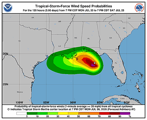

Tropical Depression Two is gradually becoming better organized over the Gulf of Mexico, according to a forecast discussion issued Monday morning by the National Hurricane Center in Miami.
Satellite images and surface observations show the storm’s low-level circulation is becoming more defined, with increased bands of thunderstorm activity forming near the center. However, data collected by an Air Force Reserve Hurricane Hunter aircraft and surface observations confirm the storm has not yet gained strength. The aircraft recorded maximum flight-level winds of 34 knots at 925 millibars, and the central pressure is around 1007 mb. Based on that data, the storm’s current intensity is set at 30 knots.
The center of the depression appears to have shifted slightly southward over the past several hours, though its overall movement remains toward the northwest at about 3 knots. Forecasters say the storm is caught between two mid-level high-pressure ridges — one to its northwest centered over the Rockies and another to its southeast near the Bahamas. As a large-scale weather trough moves into the northeastern United States, the ridge over the Rockies is expected to take over as the primary steering feature, gradually turning the storm toward the west-northwest and then westward at a slow pace.
The updated forecast track places the center near southeastern Louisiana in roughly 60 hours, then reaching southeastern Texas by the 120-hour mark. The track has been shifted slightly south compared to previous forecasts, partly due to the storm’s current position and the influence of northeasterly wind shear that may push the center a bit farther south.
The depression is currently dealing with moderate northeasterly wind shear, conditions forecasters expect to persist for another 24 to 30 hours. During that window, bursts of thunderstorm activity near and south of the center are likely to help the system strengthen into a tropical storm. After about 30 hours, the shear is forecast to increase significantly — strong enough to disrupt the storm’s vertical structure, halting intensification and causing some weakening. The peak intensity is forecast at 45 knots, expected between 36 and 48 hours from now, which is on the higher end of guidance models. Forecasters believe the system will survive through the 120-hour forecast period, though it could dissipate between 72 and 120 hours, particularly if it tracks north of the current forecast and encounters more land interaction.
Forecasters also note that the wind shear is likely to give the storm a lopsided structure, with the heaviest rainfall and strongest winds expected to occur south of the center.
Key Messages from the National Hurricane Center:
1. The depression is expected to gradually strengthen and could bring tropical storm conditions to portions of the Gulf Coast from the Florida Panhandle westward to southeastern Louisiana beginning late Monday night into Tuesday.
2. A Storm Surge Watch has been issued for the Alabama, Mississippi, and southeastern Louisiana coasts, where a life-threatening storm surge is possible.
3. Interests elsewhere in Louisiana and Texas should monitor the progress of this system, as additional watches could be required for portions of those areas later Monday or Tuesday.
4. Flash flooding will be possible through Friday along the Gulf Coast and nearby inland areas from western Florida to the middle Texas Coast, including southern portions of Alabama, Mississippi, and Louisiana.
The forecast was prepared by Forecaster Beven at the National Hurricane Center.