
The National Hurricane Center in Miami is closely monitoring Tropical Depression Two, issuing its third forecast discussion late Sunday night as the storm slowly churns in the Gulf of Mexico.
As of 10:00 PM CDT Sunday, July 19, 2026, the depression is generating a small cluster of deep thunderstorm activity near and just north of its center, with additional rain bands developing mainly in its eastern half. Satellite data and nearby surface weather observations have shown wind speeds no greater than about 20 knots, so forecasters are holding the storm’s initial intensity at 25 knots, or about 30 miles per hour — a figure also supported by a recent scatterometer pass.
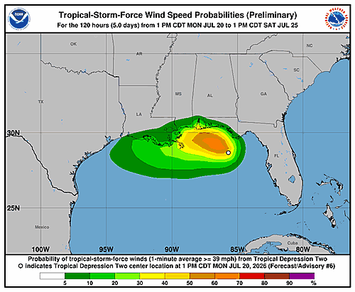
The storm is drifting slowly toward the north-northwest, caught between a high-pressure ridge over the western Atlantic and another over the south-central United States. Most weather models indicate this sluggish movement will continue into early this week, with a gradual shift toward the west-northwest. Outer rain bands from the system could begin bringing tropical storm conditions to parts of the Florida Panhandle as early as late Monday, where a Tropical Storm Watch is already in effect.
By late Tuesday, forecasters expect the storm to turn more westward and pick up forward speed as the ridge over the United States expands eastward. This would push the system along or just off the northwestern Gulf Coast through the middle and latter part of the week.
In terms of strength, only gradual intensification is anticipated. The storm’s broad structure, pockets of dry air at mid-levels, and northeasterly wind shear are limiting its ability to organize — even though it is moving over very warm water. The system is still projected to reach tropical storm status on Monday while positioned offshore of the Florida Panhandle. However, an increase in wind shear expected by Tuesday, combined with some land interaction, could stall any further strengthening.
Forecaster Blake acknowledged significant uncertainty in the intensity outlook, noting that weather models are producing a wide range of outcomes — from near dissipation according to some European and HAFS model guidance, to near hurricane strength in the latest HWRF and HMON model runs. The NHC forecast falls between those extremes, though the forecaster stated plainly: “I don’t have much confidence in this prediction given the above factors.”
Key messages from the National Hurricane Center include:
1. Tropical storm conditions could reach parts of the Florida Panhandle beginning late Monday, where a Tropical Storm Watch is in effect.
2. Residents in Alabama, Mississippi, Louisiana, and Texas should follow the storm’s progress, as watches may be issued for some of those areas within the next day or two.
3. Flash flooding will be possible through Thursday along the eastern and central Gulf Coast, from western Florida through southern portions of Alabama, Mississippi, and Louisiana.