A stretch of summer-like weather across the Delmarva Peninsula will come to an end this weekend as a cold front sweeps through the region Saturday night, bringing the potential for scattered showers and thunderstorms, including a few strong storms.
Saturday is expected to remain largely dry with warm temperatures and increasing humidity. However, attention turns to the west Saturday evening as thunderstorms develop ahead of an approaching cold front. Those storms are expected to move eastward into portions of the Mid-Atlantic during the overnight hours.

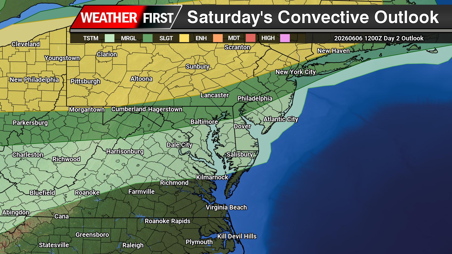
The latest outlook from the National Weather Service’s Storm Prediction Center places areas north and west of the Interstate 95 corridor under a Marginal Risk for severe weather, with a Slight Risk extending into portions of northern New Jersey and the southern Poconos. While the greatest severe threat is expected to remain northwest of Delmarva, a few stronger storms could survive long enough to reach parts of eastern Pennsylvania, New Jersey, and northern sections of the region.
Damaging wind gusts and hail are the primary threats with any stronger thunderstorms. The overnight timing is expected to limit the overall severe weather risk as storms will likely weaken after sunset and continue to diminish as they move eastward.

Rainfall amounts also appear somewhat disappointing for a region desperately in need of moisture. Forecast rainfall totals generally range from one-tenth to one-quarter inch north and west of I-95, with locally higher amounts possible under heavier thunderstorms. Some communities may receive little or no rainfall at all.
The lack of widespread rainfall continues to be a concern as portions of Delaware, Maryland, New Jersey, and Pennsylvania remain under drought watches or drought warnings. Unfortunately, this frontal passage may represent the only meaningful opportunity for measurable precipitation over the next week.
Any lingering showers along the Delaware and New Jersey beaches Sunday morning should gradually move offshore as a secondary cold front pushes through the region. Drier and less humid conditions are expected to return later Sunday, providing a pleasant finish to the weekend.
Residents are encouraged to monitor forecasts through Saturday, especially if they have outdoor plans during the evening and overnight hours. While widespread severe weather is not expected across Delmarva, a few thunderstorms could still produce gusty winds, brief heavy rain, and frequent lightning.