A surge of early-season heat is firmly in place across the Delmarva region, with record-breaking warmth expected to continue through the remainder of the week and into the upcoming weekend.

High pressure anchored over the Atlantic Ocean, combined with a warm front positioned well to the north, is allowing an unseasonably warm air mass to dominate the region. This setup is driving temperatures 20 to 40 degrees above average for mid-April, creating conditions more typical of early summer than spring.

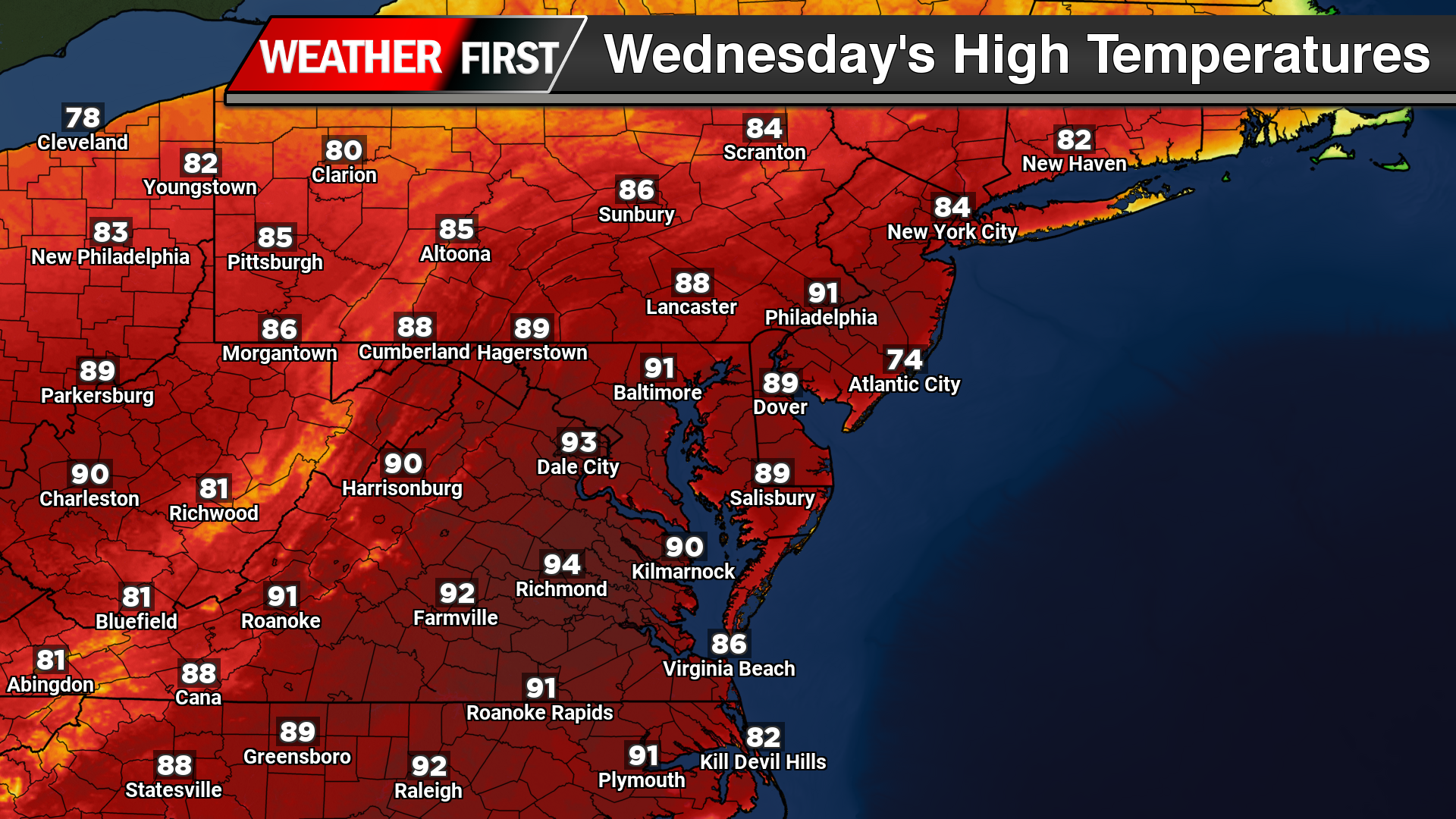
For today and tomorrow, much of Delmarva is expected to see afternoon highs climb into the upper 80s to near 90 degrees. These will likely be the warmest days of the stretch, with several locations poised to challenge or break daily high temperature records, along with records for warm overnight lows. If temperatures reach 90 degrees, it would mark the first occurrence of the year for many areas and the first since early September.

Despite the widespread heat, coastal communities along the Atlantic will experience noticeably cooler conditions. This is due to colder sea surface temperatures and the development of a daytime sea breeze, which will keep areas near the beaches significantly lower than inland locations.

A weak surface front is expected to pass through early Friday morning, but it will do little to disrupt the overall warm pattern. Temperatures will remain well above normal through the weekend, generally ranging from the mid 70s to mid 80s. A more noticeable return to seasonable conditions is expected early next week.

In addition to the warmth, dry conditions will persist across much of Delmarva. While a few isolated showers are possible at times, particularly late this week and again on Friday, rainfall amounts are expected to remain minimal, generally only a few hundredths of an inch. A better opportunity for more meaningful rainfall, potentially exceeding a tenth of an inch, may arrive on Sunday.
This extended stretch of warm and mostly dry weather is raising concerns for ongoing drought and abnormally dry conditions across the region. Without significant rainfall, conditions are likely to worsen in the short term.
Despite the dry pattern, fire weather concerns remain relatively low for now. Winds are expected to stay light, and a persistent southwest flow should keep relative humidity values above critical thresholds, limiting the potential for rapid fire spread.