Weather officials from the National Weather Service Mount Holly New Jersey office issued a severe thunderstorm warning on the evening of March 11th.
The warning went into effect at 8:43 PM Eastern Daylight Time and remained active until 9:15 PM EDT on March 11th.
The alert was distributed through the National Weather Service’s official warning system to notify residents of potentially dangerous weather conditions in the area.
Weather officials from the National Weather Service’s Mount Holly, New Jersey office issued a severe thunderstorm warning on March 11th during the evening hours.
The alert was activated at 8:11 PM Eastern Daylight Time and remained active until 8:30 PM EDT on the same date, covering a brief 19-minute period.
The warning was distributed through the agency’s alert system and assigned the identifier urn:oid:2.49.0.1.840.0.34c678eb29a664670e735caea70bfb0ed88d72f5.001.1.cap in their notification database.
The National Weather Service Mount Holly office activated a severe thunderstorm warning Monday evening, alerting residents to dangerous weather conditions in the region.
Weather officials issued the warning at 7:48 PM on March 11th, with the alert scheduled to remain active until 8:30 PM the same evening.
The 42-minute warning provided residents with advance notice of potentially hazardous thunderstorm activity moving through the area during the evening hours.
The Mount Holly National Weather Service office, which monitors weather conditions across the region, issued the alert as part of their ongoing severe weather monitoring operations.
Despite winter still being officially in effect, Southern California residents are preparing for sweltering conditions more typical of summer, with weather experts forecasting extraordinarily high temperatures that could reach 93 degrees in downtown Los Angeles.
The National Weather Service reports that temperatures will climb approximately 20 degrees higher than typical mid-March weather, creating dangerous conditions that increase the likelihood of heat-related illnesses. Officials are advising residents to limit outdoor exposure during peak daytime hours.
“If you must be outdoors, drink a lot of water,” advised Richard Thompson, a meteorologist with the weather service’s Los Angeles office. “There’s definitely the potential for records being set.”
Thursday is anticipated to bring the most extreme conditions to the Los Angeles area, with thermometers potentially climbing to 95 degrees in the San Fernando Valley. Thompson noted that normal temperatures for this time of year typically hover around 70 degrees.
Construction crews are taking extra precautions to protect outdoor workers, ensuring ample water supplies and electrolyte supplements are readily available while mandating regular rest periods, according to Junior Pineda, who represents a local chapter of the International Union of Bricklayers & Allied Craftworkers.
“And there’s always shade structures, if guys start feeling a little light-headed and need to take a few minutes,” Pineda explained.
City and county authorities in Los Angeles are preparing to activate cooling centers to provide relief for residents who lack air conditioning in their homes.
Zack Marquez, a wheelchair user, was completing his daily tasks Wednesday in LA’s Koreatown district before the heat became too intense.
“Gotta stay hydrated and stay in the shade,” Marquez commented.
While coastal areas may experience some relief from ocean breezes on Friday, interior regions will continue to endure oppressive heat, meteorologists predict.
The timing coincides with Hollywood’s biggest night, as celebrities gather in Los Angeles for this Sunday’s Oscar ceremony, with numerous events scheduled throughout the week capitalizing on the star-studded atmosphere. However, weather conditions should improve before the awards show takes place.
The unusual heat pattern will extend beyond Los Angeles next week, affecting other parts of California. The San Francisco Bay Area and Sacramento region could see temperatures exceeding 90 degrees by Monday.
Weather officials have issued a severe thunderstorm watch for the region, alerting residents to potentially dangerous storm conditions developing this evening.
The National Weather Service office in Mount Holly, New Jersey issued the watch at 7:03 PM today, with the alert remaining in effect until 11:00 PM tonight.
During a severe thunderstorm watch, conditions are favorable for the development of storms that could produce damaging winds, large hail, and dangerous lightning. Residents are advised to stay alert and monitor local weather conditions throughout the evening.
The weather service recommends having a plan in place and being ready to take shelter if severe weather develops in your area.
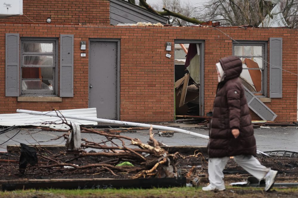
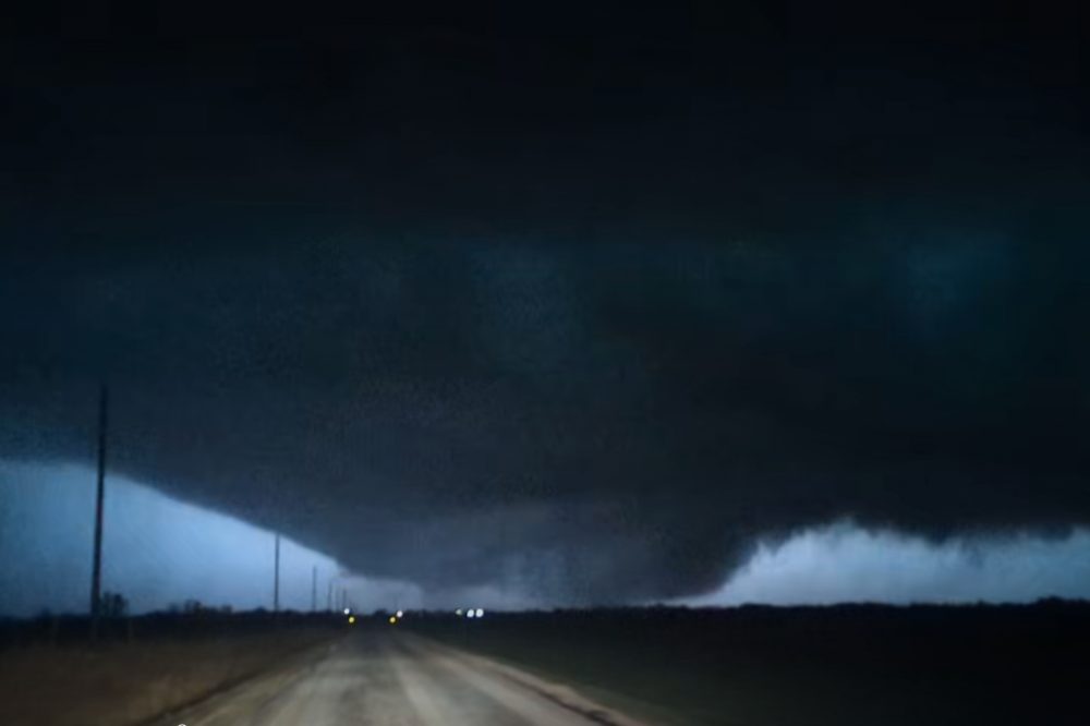
Destructive weather systems moved through northern Illinois and northwest Indiana, generating several tornadoes that left extensive damage across both states.
The severe weather event produced multiple tornado touchdowns, resulting in significant destruction throughout the affected regions.
Visual documentation compiled by Associated Press photographers captures the extensive impact left behind by the storm system as it moved through the area.
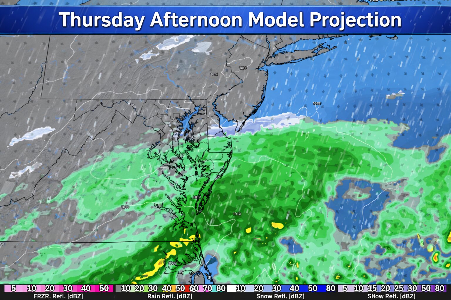
A strong cold front moving through the region early Thursday morning will bring a dramatic change in the weather across the Delmarva Peninsula, replacing the recent warmth with gusty winds and much colder temperatures through the day.
Behind the cold front, a surge of colder air will rapidly move in from the west. Temperatures will start the day relatively mild early Thursday morning, but readings will steadily fall throughout the day as the colder air takes hold. Many areas across Delmarva are expected to drop from the 50s during the morning into the 40s by the afternoon.
As the front moves offshore, a small disturbance riding along the boundary may produce a few additional showers across the region during the morning and early afternoon. Some forecast models suggest the possibility of rain briefly mixing with wet snow before ending, particularly as colder air deepens in the atmosphere. However, this scenario may be overdone as much drier air quickly moves in behind the front.
With the incoming dry air likely to shut down precipitation fairly quickly, any lingering showers should taper off from west to east through the day. Even if a brief rain and snow mix were to occur, temperatures will remain above freezing, meaning no snow accumulation is expected.
The most noticeable change on Thursday will likely be the wind. Strong northwest winds will develop behind the cold front as colder air pours into the region. Gusts are expected to reach between 30 and 40 mph through much of the morning and into the early afternoon hours. These winds will combine with falling temperatures to make conditions feel significantly colder compared to the mild weather earlier in the week.
Winds will gradually begin to ease later Thursday afternoon and into the evening, but the colder air will remain firmly in place.
By Thursday night, temperatures across Delmarva are expected to drop sharply, with overnight lows falling into the upper 20s to lower 30s by early Friday morning. The colder conditions will mark a stark contrast from the unseasonably warm weather experienced just a day earlier.
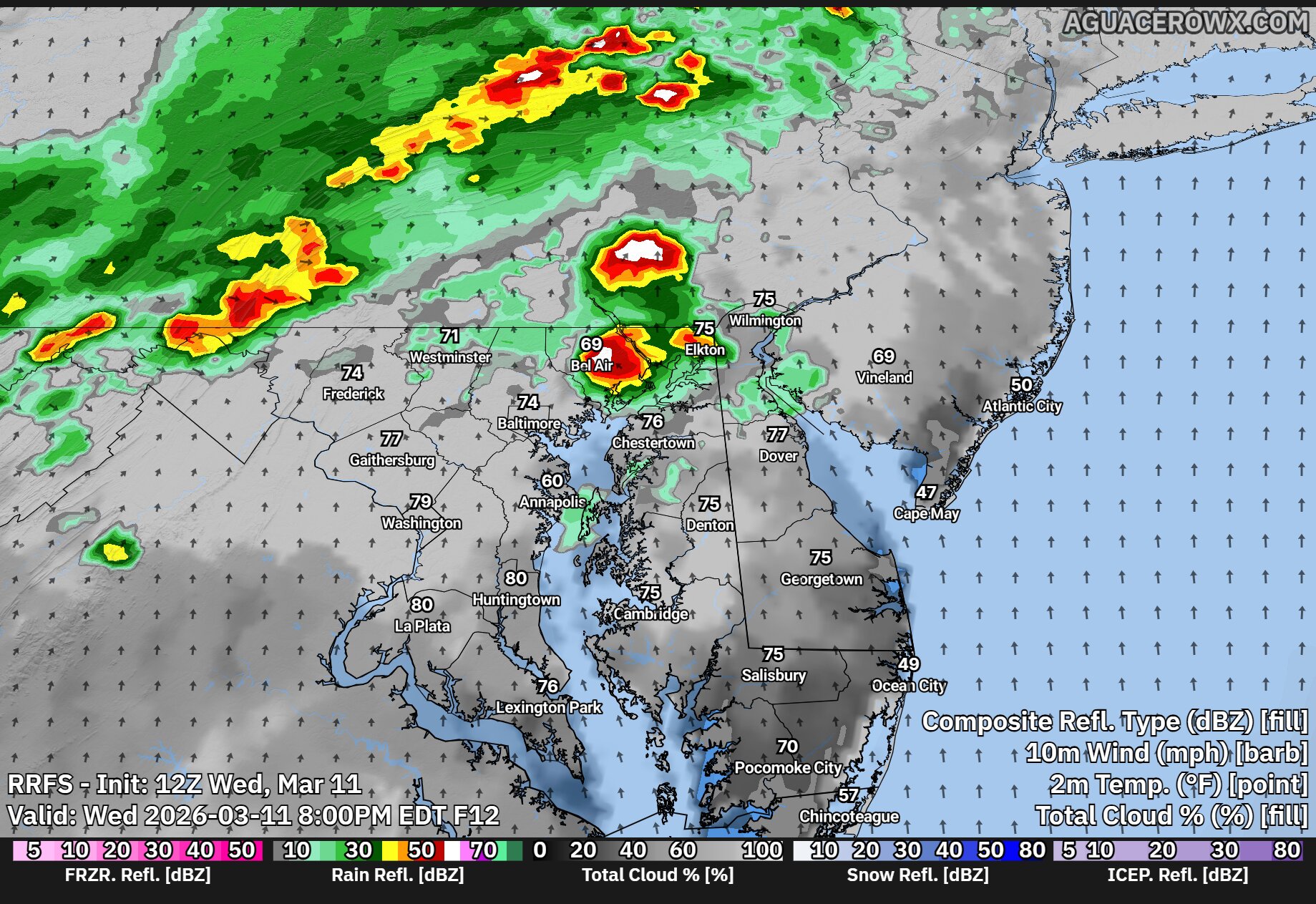
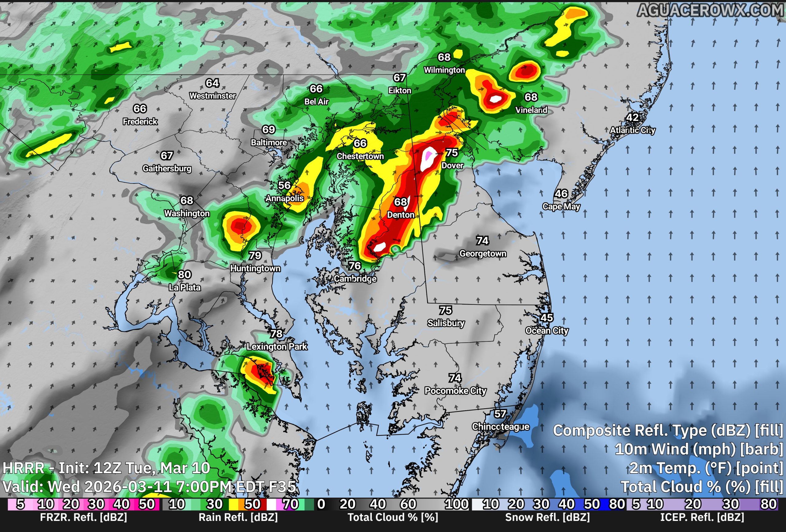
Residents across the Delmarva Peninsula should remain alert Wednesday afternoon and evening as a developing weather system may bring the potential for strong to severe thunderstorms before a powerful cold front sweeps through the region overnight.
A strengthening area of low pressure moving across the eastern Great Lakes this afternoon will track into southern Quebec tonight. As this system intensifies, it will drag a strong cold front eastward across the Mid-Atlantic, arriving in the Delmarva region late tonight into early Thursday morning.
Ahead of the front, a warm and increasingly humid air mass will settle across the region during the day Wednesday. Temperatures will climb well above normal, while dew points rise into the upper 50s and lower 60s. This combination of warmth and moisture will help create a favorable environment for thunderstorms to develop.
We are closely watching a pre-frontal trough expected to form over central Pennsylvania during the afternoon. Thunderstorms that develop along this feature could organize and move eastward into the Delmarva region by mid to late afternoon and into the early evening hours.
Strong winds in the atmosphere will help support organized storm development. Forecast models indicate wind shear values of around 40 to 50 knots, which can help storms organize into line segments capable of producing damaging wind gusts. Some storms may also produce small hail, generally around quarter size, and there is a low but non-zero chance that an isolated tornado could occur.
The overall severe weather threat will depend heavily on how much sunshine develops during the day. If clouds remain widespread or if morning showers limit daytime heating, the atmosphere may not become unstable enough to support stronger storms. However, if breaks of sunshine develop, particularly across southern and western parts of the region, storm intensity could increase.
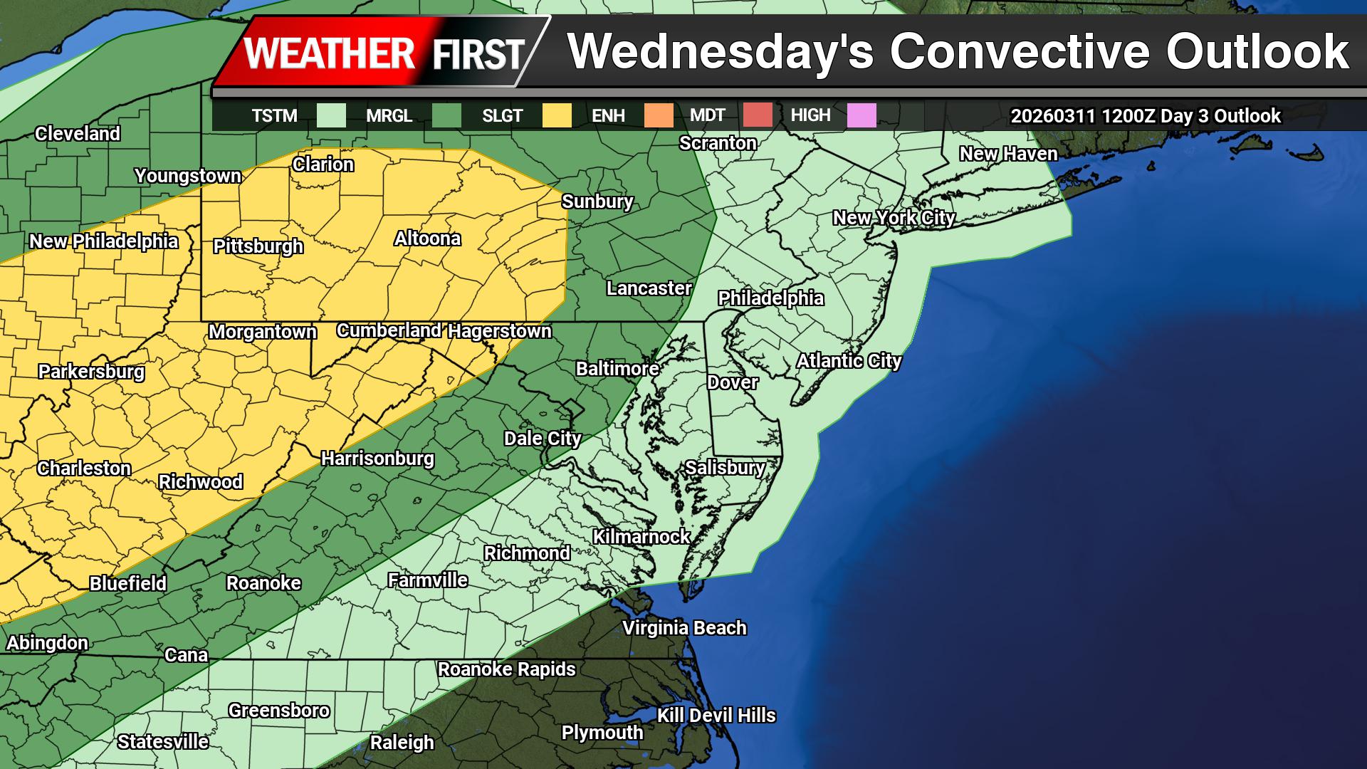
Current guidance suggests that areas south and west of Philadelphia have the greatest potential for stronger storms. The Storm Prediction Center has placed these areas in a Slight Risk, or Level 2 out of 5, for severe weather. Closer to the coast, including parts of coastal Delaware and New Jersey, the threat is lower due to cooler marine air moving in from the Atlantic Ocean, which tends to stabilize the atmosphere.
After the initial round of thunderstorms moves through Wednesday evening, activity may decrease overnight with only scattered showers expected for a time. The main cold front is forecast to cross the region early Thursday morning. Most of the rain associated with the front appears likely to occur after the boundary passes, which should limit any additional severe weather threat.
Temperatures will remain unusually warm overnight until the cold front moves through. Once the front passes early Thursday morning, temperatures will begin to drop quickly, signaling the arrival of cooler air across the region to start the day.
Destructive weather systems spawned multiple tornadoes across Illinois and Indiana Tuesday, demolishing houses, toppling trees and electrical lines, and flooding a 911 dispatch center near Chicago with distress calls, authorities reported.
“Please do not come here. Do not try to help right now,” Newton County Sheriff Shannon Cothran warned in a video message recorded in front of what appeared to be a demolished residence in Lake Village, a small community in northwestern Indiana.
Numerous houses in the area were flattened by what appears to have been a tornado, and Indiana State Police Cpl. Eric Rot confirmed that residents sustained injuries. However, he could not specify how many people were hurt or detail their medical status.
Powerful weather systems bringing heavy rainfall and hail across Midwest regions threatened to produce violent tornadoes, destructive winds and oversized hail stretching from the southern Plains through the southern Great Lakes, the National Weather Service reported. Tornado watches extended from Oklahoma through Michigan.
Multiple tornadoes developed throughout northeastern Illinois and northwestern Indiana, though the precise count will remain unknown until authorities complete damage assessments, explained Andrew Lyons, a meteorologist with the weather service Storm Prediction Center.
Lyons characterized the event as a standard early spring severe weather outbreak. The system is forecast to continue eastward through portions of the mid-Atlantic and East Coast on Wednesday, potentially delivering additional severe conditions, he noted.
Illinois Gov. JB Pritzker announced on social media platform X that he had received briefings about the storm and tornado destruction.
“Keeping in our thoughts all Illinoisans impacted by the severe weather — we’ll be here to help them recover,” he stated.
One tornado touched down near the Kankakee fairgrounds, approximately 57 miles south of Chicago, then moved northeast into Aroma Park, causing widespread destruction, the Kankakee County Sheriff’s Office confirmed. Officials reported no injuries in that area.
“I want to remind area residents to check on their neighbors and loved ones but to avoid unnecessary travel, if at all possible,” Kankakee County Sheriff Mike Downey stated.
Social media footage captured the tornado cutting through agricultural fields near an airport as vehicles gathered along nearby roadways.
Over 2 million Americans faced moderate severe weather risks in Illinois and Indiana. An additional 22 million people encountered slightly lower risks across a broader area encompassing Chicago, Fort Worth, Texas, and Oklahoma City, Oklahoma.
A strong cold front is expected to move through the region late Wednesday night into early Thursday morning, bringing a period of showers and possibly a few strong thunderstorms.
Ahead of the front, warmer and more humid air will move into the area Wednesday. This could help showers and a few thunderstorms develop as the cold front approaches overnight. While a few storms could become strong, the overall threat for severe weather across Delmarva appears to be relatively lower.
One reason for the lower risk locally is the influence of the Atlantic Ocean. Water temperatures are still very cold this time of year, which creates a stable marine layer near the coast. This cooler, more stable air can weaken storms as they move east toward the Delmarva Peninsula.
The greater risk for stronger storms is expected to remain farther inland, mainly west of our area, where conditions will be more favorable for storms to stay organized with the threat of strong winds, some small hail and a limited tornado risk across Western Maryland.
Even so, residents across Delmarva should expect periods of showers and rounds of thunder late Wednesday night into early Thursday morning.
After the cold front moves through Thursday morning, temperatures will begin to fall during the day as much colder air moves in. In fact, the warmest temperatures Thursday may occur just after midnight before dropping into the 40s by late afternoon with gusty northwest winds.
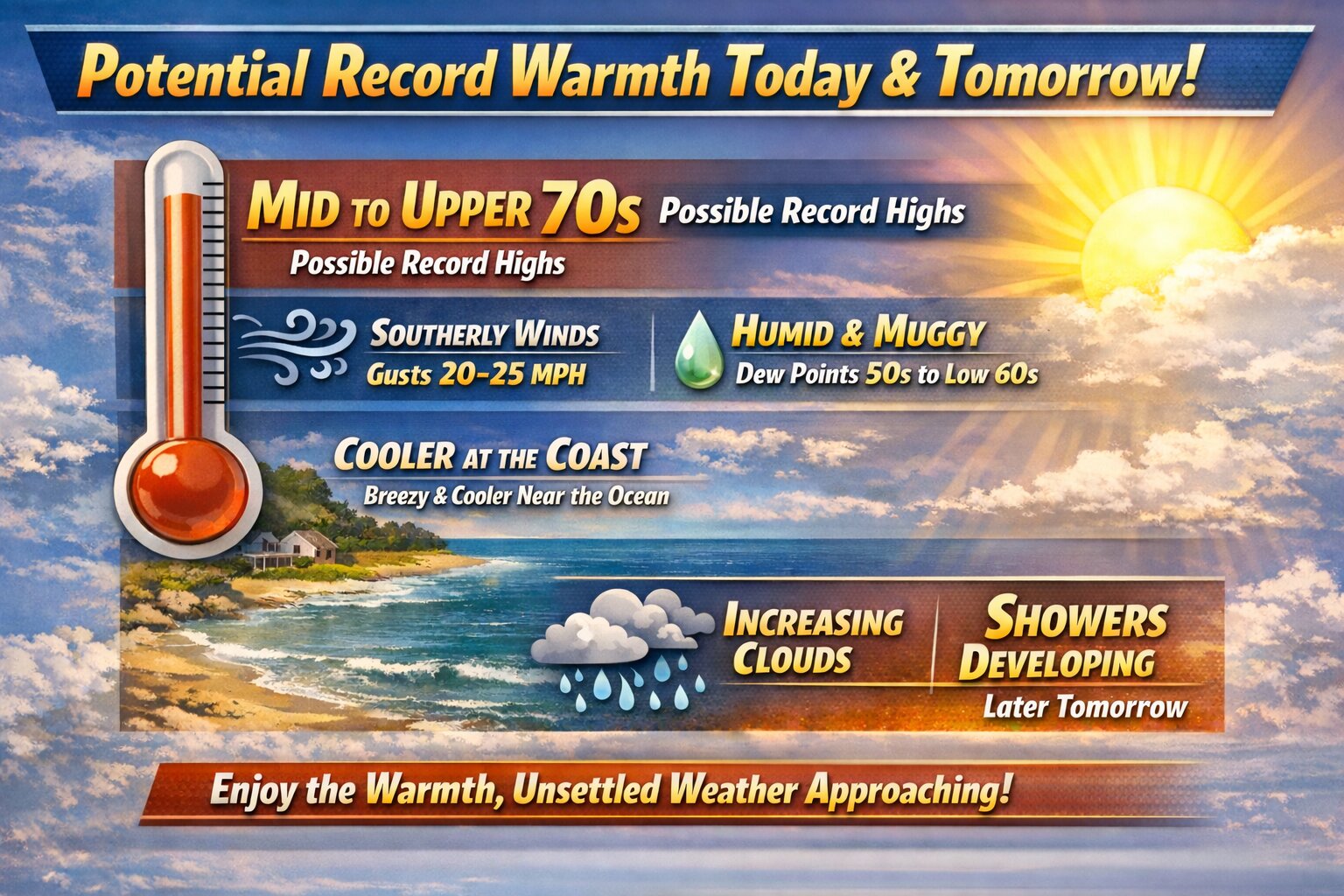
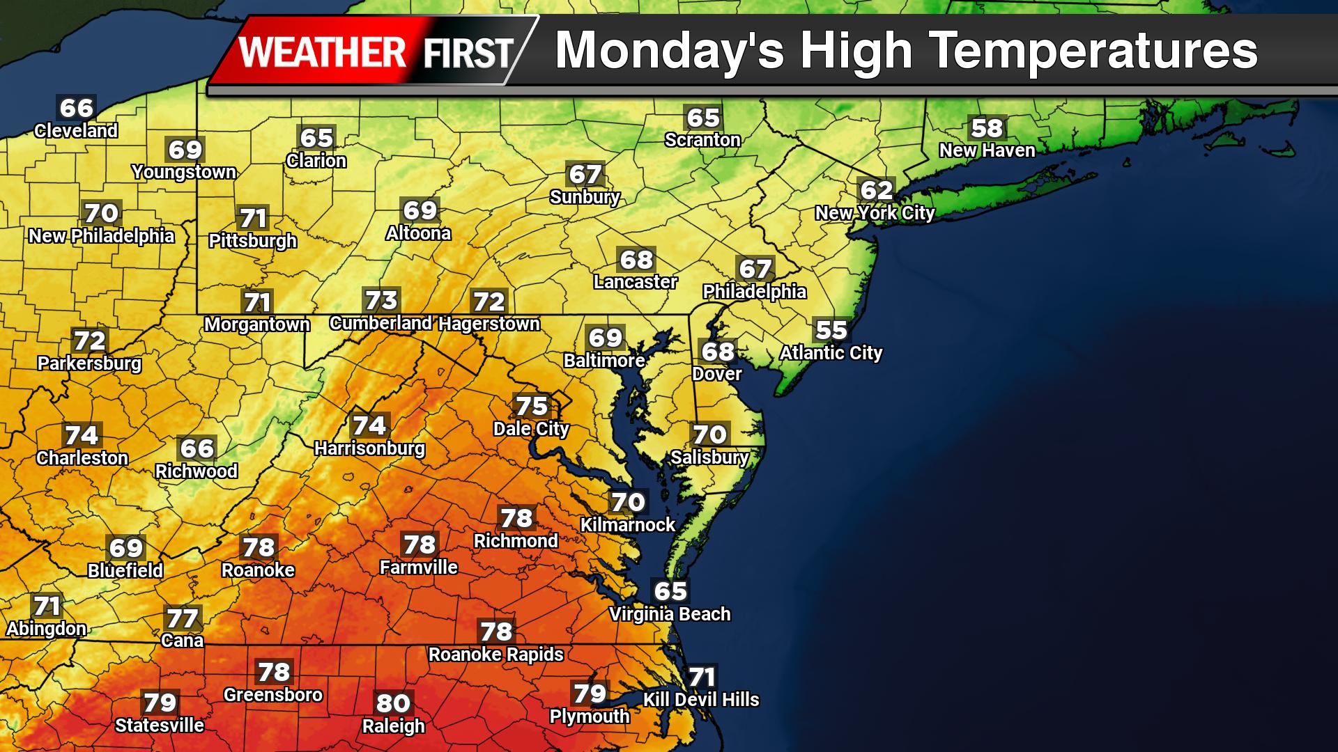
Unseasonably warm air is moving into the region today as strong southerly winds bring a much milder and more humid airmass across Delmarva. Afternoon temperatures are expected to climb into the mid to upper 70s, putting some locations within reach of record high temperatures for this time of year. And a few isolated areas have a shot of near 80 degrees!
Winds will increase from the south to southwest with gusts up to 20 to 25 mph, helping push the warm air northward. Humidity will also increase, with dew points rising into the upper 50s and low 60s, making it feel more like late spring than early March.
Areas along the immediate coast will likely stay a bit cooler due to the southerly wind coming off the still-cold Atlantic Ocean, but inland communities could see temperatures approach daily records.
Cloud cover will gradually increase through the day Wednesday, and a few showers may begin developing later in the afternoon, especially across western parts of the region ahead of an approaching cold front.
After several days of unseasonably warm weather across the Delmarva Peninsula, a strong cold front is expected to sweep through the region Wednesday night into Thursday, bringing widespread showers and the possibility of a few thunderstorms.
The weather pattern will begin to turn more active by midweek as a potent upper-level trough moves east from the central United States. As this system approaches, large-scale lift in the atmosphere will begin increasing across the Mid-Atlantic during the day Wednesday.
The first showers may begin to develop Wednesday afternoon, mainly across areas north and west of the Interstate 95 corridor. Much of Delmarva should remain mostly dry during the daytime hours, though clouds will likely increase through the afternoon.
Rain chances will increase significantly Wednesday night as the main system approaches. A surface low associated with the upper trough is forecast to track north of the region through the Great Lakes and into southern Canada. Trailing behind that system will be a strong cold front, which is expected to move through the Mid-Atlantic early Thursday morning.
As the front approaches Wednesday night, a line of showers is expected to move across the region, bringing a period of widespread rainfall. While the overnight timing should limit the potential for severe weather, forecasters say there is still a slight chance for isolated thunderstorms due to some elevated instability in the atmosphere.
In addition to the rain, winds are expected to become increasingly gusty as the system moves through. Even outside of heavier showers, a strengthening wind field in the atmosphere could lead to occasional gusts across the region late Wednesday night and into Thursday.
Behind the cold front, rain will gradually taper off during the day Thursday as colder air begins filtering into the Mid-Atlantic. A few lingering rain or even brief snow showers cannot be ruled out later Thursday as temperatures fall.
This system will mark the end of the recent stretch of spring-like warmth, with cooler conditions expected to return to the Delmarva region heading into the end of the week.
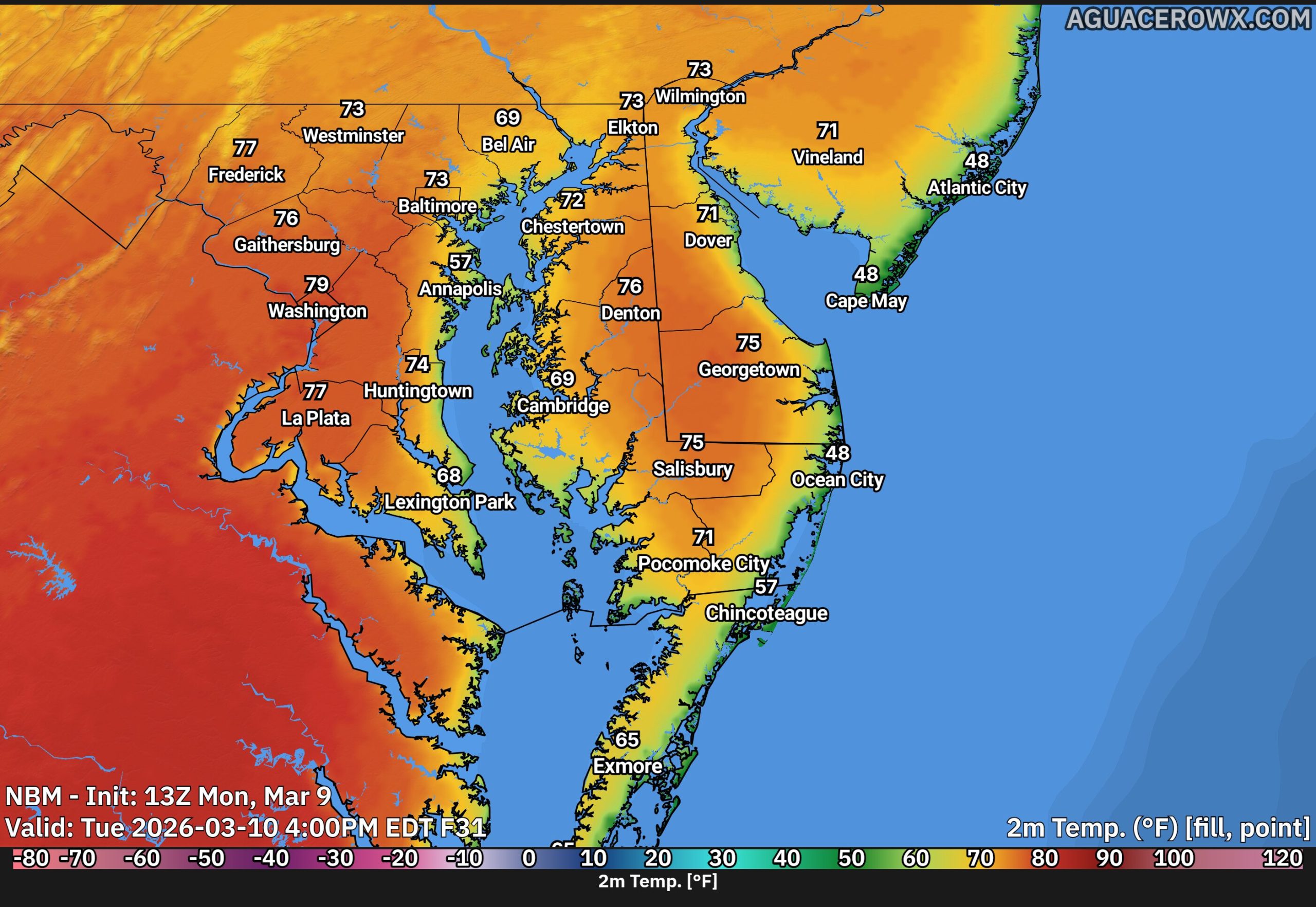
A stretch of unusually warm weather is expected across the Delmarva Peninsula through Wednesday, with temperatures running well above average for early March and potentially approaching record levels in some locations.
The warm pattern is being driven by a stable upper-level weather pattern combined with high pressure positioned over the western Atlantic Ocean. This setup acts almost like a heat pump, allowing very mild air to surge northward into the Mid-Atlantic region.
As a result, daytime temperatures across much of Delmarva are forecast to climb into the low to mid 70s through midweek. That is roughly 20 to 25 degrees warmer than normal for this time of year. Overnight temperatures will also remain mild, with lows generally falling into the 40s and 50s.
The warm temperatures will be most noticeable inland across Delaware and Maryland’s Eastern Shore. However, communities along the Atlantic coast will stay noticeably cooler due to the influence of the chilly ocean waters. High temperatures near the beaches are expected to remain mostly in the 50s as a daily sea breeze develops during the afternoon hours.
While record temperatures appear unlikely on Tuesday, some locations could challenge or even break daily record highs by Wednesday if the warm air remains firmly in place.
Another feature of this mild pattern will be the development of fog, especially during the nighttime and early morning hours. Increasing moisture in the atmosphere combined with cool ocean temperatures will create favorable conditions for fog formation. Coastal areas will be most prone to fog, but it may spread farther inland overnight before dissipating each morning.
Despite the fog potential, the overall pattern remains quiet and stable through midweek, bringing a prolonged period of spring-like warmth to the Delmarva region.
Weather officials have issued a dense fog advisory for the Delmarva region, warning residents of potentially hazardous driving conditions during the early morning hours.
The National Weather Service office in Mount Holly, New Jersey issued the advisory at 1:10 AM on March 9th, with the warning remaining active until 10:00 AM the same day.
Motorists are advised to exercise extreme caution during the advisory period, as visibility may be significantly reduced. Drivers should reduce speeds, use low-beam headlights, and maintain greater following distances when traveling in foggy conditions.
The weather service typically issues these advisories when visibility is expected to drop to one-quarter mile or less due to fog formation.
Dense fog conditions have developed across Delaware, creating potentially dangerous driving conditions for commuters and travelers throughout the First State.
The Delaware Department of Transportation reports that visibility has been significantly reduced in multiple areas, with fog intensity fluctuating from location to location across the state.
Officials are strongly encouraging all drivers to exercise extreme caution when behind the wheel during these challenging weather conditions. Reduced visibility can make it difficult to see other vehicles, road signs, and potential hazards on the roadway.
Motorists should consider reducing their speed, increasing following distances, and using low-beam headlights when navigating through foggy areas. Drivers may also want to delay non-essential travel until conditions improve.
Dense fog conditions with varying visibility levels have settled across Delaware, prompting state transportation officials to issue a safety advisory for drivers.
The fog has been reported statewide with different levels of thickness affecting visibility on roadways throughout Delaware. DelDOT is urging all motorists to exercise extra caution when driving in these challenging weather conditions.
Drivers are reminded to reduce speed, increase following distance, and use low-beam headlights when navigating through foggy areas. The fog conditions may continue to impact travel throughout the day.
The National Weather Service office in Mount Holly, New Jersey has issued a dense fog advisory for the area this morning, effective from 6:20 AM until 9:00 AM EDT on March 8th.
Motorists should exercise caution during their morning commute as visibility may be significantly reduced. Dense fog conditions can create hazardous driving situations, particularly on highways and rural roads.
The weather service recommends reducing speed, using low-beam headlights, and maintaining extra distance between vehicles when traveling in foggy conditions. Drivers should also be prepared for sudden changes in visibility.
The advisory is expected to be lifted by 9:00 AM as atmospheric conditions improve throughout the morning hours.
Weather forecasters from the National Weather Service Mount Holly office issued a dense fog warning early Friday morning at 4:14 AM, alerting residents to hazardous visibility conditions expected to persist until 7:00 AM.
The advisory warns of significantly reduced visibility due to thick fog covering the region during the early morning hours. Motorists are urged to exercise extreme caution when traveling and allow extra time for their commutes.
Dense fog can create dangerous driving conditions by limiting visibility to just a few hundred feet or less. Drivers should reduce speed, use low-beam headlights, and maintain greater following distances during these conditions.
The fog advisory is scheduled to expire at 7:00 AM as morning temperatures rise and atmospheric conditions improve throughout the region.
The National Weather Service Mount Holly office has issued a dense fog advisory that went into effect Monday afternoon at 1:08 PM and will remain active until 10:00 AM Tuesday morning.
The weather advisory warns of significantly reduced visibility conditions that could impact travel and daily activities across the region.
Motorists are advised to exercise extreme caution when driving during foggy conditions, as visibility can drop dramatically and create hazardous road conditions.
Delaware Department of Transportation officials have implemented a temporary speed reduction on Interstate 495, lowering the maximum speed to 55 miles per hour due to dense fog affecting visibility along the highway.
The speed restriction has been put in place as a safety precaution to help prevent accidents during the hazardous driving conditions caused by the thick fog blanketing the area.
Motorists traveling on I-495 are advised to reduce their speed, increase following distance, and exercise extra caution while the foggy conditions persist.
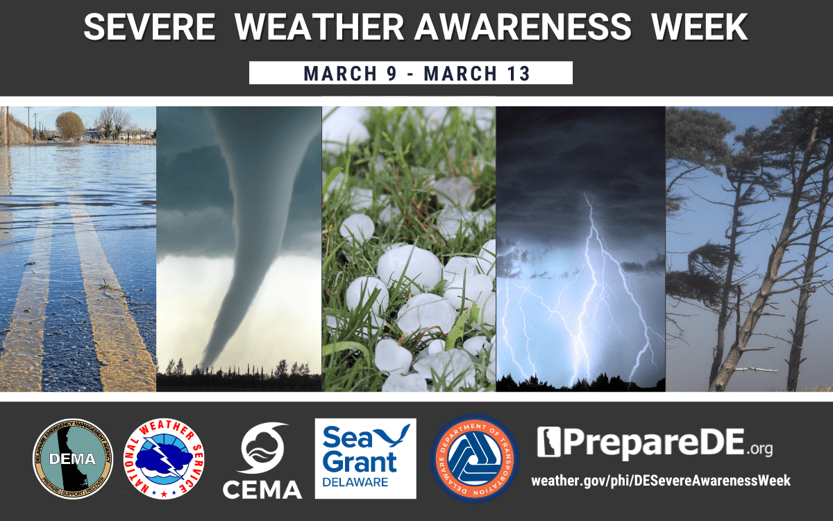
Delaware Governor Matt Meyer has officially designated March 9-13, 2026 as Severe Weather Awareness Week, aimed at boosting emergency preparedness and protecting public safety throughout the First State.
The weeklong initiative will feature collaborative efforts between state agencies and community organizations to educate residents about severe weather safety through digital outreach programs.
A key highlight of the awareness week will be a panel discussion titled “Then & Now: Navigating Delaware’s Evolving Severe Weather Landscape,” scheduled for March 10 from 3:00 to 4:30 p.m.
The proclamation comes as part of ongoing efforts to help Delaware residents better prepare for and respond to severe weather events that can impact communities across the state.
Emergency responders are sifting through extensive wreckage following deadly tornado activity that claimed six lives across Michigan and Oklahoma, including a 12-year-old child.
The fatal twisters were part of a widespread severe weather system that moved through the nation’s midsection, leaving communities devastated in their wake.
Rescue teams continue their painstaking work through damaged areas, searching for survivors and assessing the full scope of destruction caused by the powerful storms.
The tragic loss of life includes the young boy, highlighting the deadly nature of the weather event that struck the region.
Officials are working to determine the exact path and strength of the tornadoes as affected communities begin the long process of recovery and cleanup.
Devastating weather systems swept across Michigan and Oklahoma, creating widespread destruction that demolished houses and left debris scattered throughout affected communities. Local volunteers have mobilized to assist residents as they search through the wreckage and start the long process of rebuilding their lives.
The severe weather threat continues to pose risks across the central United States as communities work to recover from the latest round of destructive storms.
This collection of images was compiled by Associated Press photography staff to document the aftermath and recovery efforts.
Delaware Department of Transportation officials are urging drivers to exercise extreme caution while navigating Stanton Christiana Road due to dangerous flooding conditions affecting the thoroughfare.
The transportation agency has issued a safety advisory alerting commuters to the hazardous road conditions that have developed along this route. Officials are recommending that drivers consider alternative routes when possible to avoid the flooded sections.
DelDOT continues to monitor the situation and will provide updates as conditions change. Motorists are reminded that driving through flooded roadways can be extremely dangerous and potentially deadly.
Weather authorities from the National Weather Service Mount Holly office have issued a fog advisory for the region, warning residents of significantly reduced visibility conditions throughout the morning hours.
The advisory went into effect at 9:48 AM on March 7th and is expected to remain active until 12:00 PM EST today. Officials are urging motorists to exercise extreme caution while traveling during these hazardous conditions.
The thick fog has created dangerous driving conditions with visibility dropping to dangerously low levels across the affected areas. Residents are advised to allow extra travel time and reduce speeds when venturing out during the advisory period.
Weather officials recommend using low-beam headlights and maintaining safe following distances while the dense fog persists. The conditions are expected to gradually improve as the morning progresses toward the noon hour.
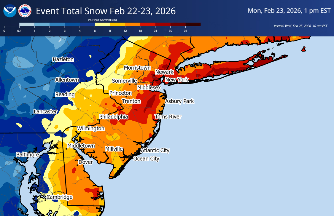
The National Weather Service in Mount Holly, New Jersey has confirmed that blizzard conditions occurred across portions of coastal New Jersey and Delaware during the early morning hours of February 23.
According to a public information statement released Friday afternoon, sustained winds or frequent gusts of 35 mph combined with falling and blowing snow reduced visibility to less than a quarter mile for at least three hours in several locations. Counties meeting blizzard criteria include Middlesex, Monmouth, Ocean, Burlington, Atlantic, and Cape May in New Jersey, along with Sussex County in Delaware. Both inland and coastal sections of many of these counties experienced the conditions.
The National Weather Service notes that the verification data is still considered preliminary until it is finalized and officially entered into the NWS StormData database. Exact start and end times for the blizzard conditions will be documented once the verification process is complete.
The National Weather Service office in Mount Holly, New Jersey has issued a dense fog advisory that took effect at 4:00 AM on March 7th and will remain active until 10:00 AM the same day.
Motorists should exercise extreme caution during morning commute hours as visibility may be significantly reduced due to the thick fog conditions.
Drivers are advised to reduce speeds, use low-beam headlights, and maintain extra distance between vehicles when traveling during the advisory period.
The National Weather Service has lifted the dense fog advisory that was previously issued for the region.
Weather officials determined that visibility conditions have improved sufficiently to warrant canceling the advisory. The warning had been put in place to alert drivers and residents about potentially hazardous travel conditions due to reduced visibility.
Motorists should continue to exercise caution during early morning and evening hours when fog conditions can still develop, even though the official advisory is no longer active.
Dense fog conditions have developed across Delaware, creating hazardous driving conditions with reduced visibility throughout the First State.
The Delaware Department of Transportation reports that fog of different intensities has been spotted in communities statewide, prompting officials to issue a safety advisory for drivers.
Transportation authorities are encouraging all motorists to exercise extreme caution when behind the wheel during these weather conditions. Reduced visibility from fog can significantly impact a driver’s ability to see other vehicles, road signs, and potential hazards.
Drivers should reduce their speed, increase following distance, and use low-beam headlights when navigating through foggy conditions. High-beam headlights can actually make visibility worse by reflecting off the fog.
Deadly tornadoes swept across southern Michigan on Friday, claiming four lives and leaving more than a dozen people injured as the violent storms demolished homes and knocked out electricity for hundreds of residents, according to local officials.
Social media videos appearing to show the aftermath in Three Rivers and Union City captured massive funnel clouds ripping rooftops from structures and hurling debris skyward, shortly after the National Weather Service had issued tornado warnings for the region.
News footage revealed the destruction left behind: demolished buildings and vehicles, along with downed utility poles, fallen trees, and toppled road signs scattered across the landscape.
Branch County, home to Union City, reported three deaths and a dozen people wounded, the sheriff’s department confirmed.
Cass County authorities reported one additional fatality and several more injuries in their jurisdiction.
According to an official Cass County statement, “Multiple large structures – including homes and pole barns – sustained damage ranging from major structural impacts to complete destruction.”
Hundreds of residents remained without electricity following the storms, local officials reported.
An official Facebook post from Union City detailed the extensive damage: “We have multiple utility poles down, transformers damaged, and long stretches of power lines on the ground. The north side of Union Lake sustained some of the most severe damage, with roughly two miles of line brought down in that area alone.” The post warned that power restoration could take several days.
Michigan Governor Gretchen Whitmer responded by activating the State Emergency Operations Center to monitor the developing situation.
Clayton Cummins, a spokesperson for Michigan emergency services and police, told reporters: “The state is ready to fulfill any resource requests that may arise. We’ve yet to receive any just yet. It’s sounding like the local response is and has been able to address what’s been a very devastating afternoon and evening in southwest Michigan.”
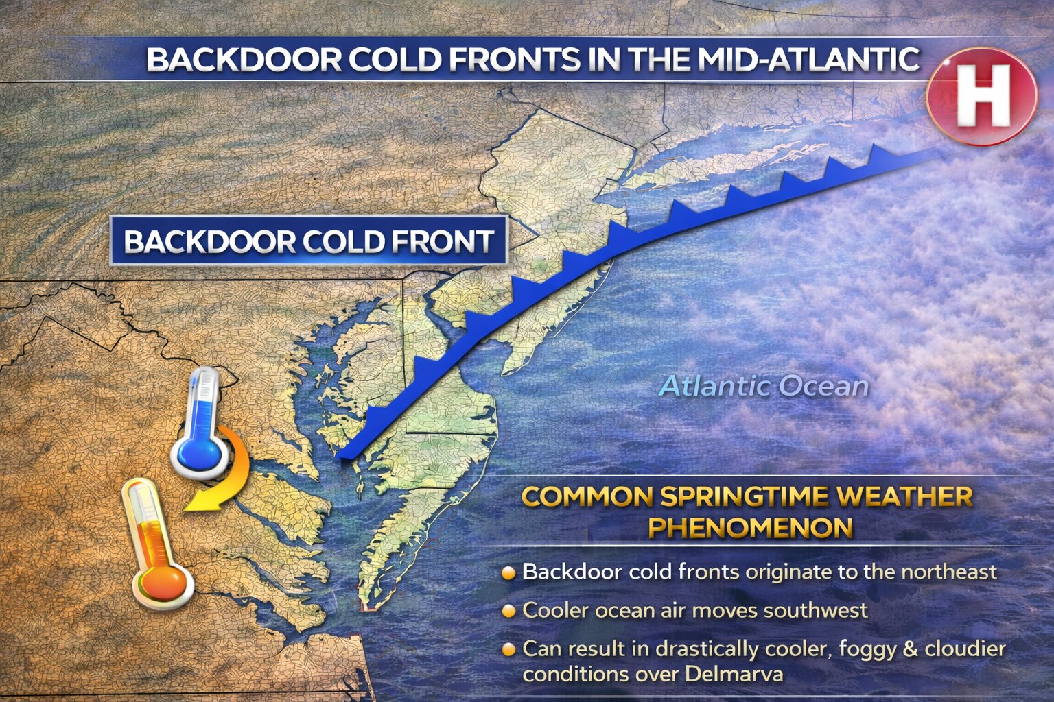
Spring weather across the Mid Atlantic can be notoriously difficult to forecast, and one of the biggest reasons is the frequent appearance of backdoor cold fronts. These unique weather boundaries often bring sudden temperature changes, shifting winds, and coastal clouds that can dramatically alter the forecast across the Delmarva Peninsula.
What Is a Backdoor Cold Front?
A backdoor cold front is a type of cold front that moves in from the northeast rather than from the west or northwest, which is the typical direction for most cold fronts in the United States.
Instead of sweeping across the region from the interior of the country, these fronts originate over New England or the North Atlantic and slide southwestward down the coastline. As the front moves through the Mid Atlantic, cooler air from the ocean and coastal regions pushes inland, replacing warmer air that had previously moved northward.
This process often results in rapid temperature drops, especially near the coast. It is not uncommon for areas along the Delmarva coast to see temperatures fall 10 to 20 degrees within a few hours after a backdoor front moves through.
Why Backdoor Fronts Are Common in the Spring
Backdoor cold fronts become especially common during the spring months across the Mid Atlantic because of the strong temperature contrast between land and water.
During spring, the land across the Mid Atlantic warms quickly as the sun angle increases. However, the Atlantic Ocean and nearby bays remain much colder after the winter months. This temperature difference creates the perfect setup for cooler marine air to surge inland.
At the same time, strong high pressure systems often build over eastern Canada or New England during the spring. These high pressure systems drive cooler air southwestward along the coastline, pushing the front toward areas such as New Jersey, Delaware, Maryland, and Virginia.
Because the cooler air mass travels over cold ocean water, it is typically moist and stable, which often leads to low clouds, fog, and occasionally drizzle behind the front.
A Major Forecast Challenge for Delmarva
Backdoor cold fronts are particularly challenging to forecast for the Delmarva Peninsula because of the region’s geography. Surrounded by the Atlantic Ocean, Delaware Bay, and Chesapeake Bay, the peninsula sits in a location where marine air can easily influence temperatures.
One of the biggest forecasting difficulties is determining how far inland the cooler air will push. Sometimes the front stalls near the coast, leaving inland communities much warmer. Other times it surges rapidly across the peninsula, causing temperatures to fall dramatically.
For example, on some spring days it may be near 70 degrees in western Maryland while coastal Delaware remains stuck in the 40s or 50s under cloudy skies and northeast winds.
Another challenge is that these fronts often stall and move back and forth across the region. Small shifts in wind direction or pressure patterns can cause the boundary to drift north or south, which can quickly change temperatures, cloud cover, and precipitation chances.
The Role of the Ocean and Sea Breezes
The cold Atlantic waters also enhance the effects of backdoor fronts across Delmarva. Even after the front passes, persistent onshore winds and sea breezes can keep coastal communities significantly cooler than inland areas.
This marine influence is why coastal locations such as Rehoboth Beach, Ocean City, and Cape Henlopen often experience cooler temperatures and fog while inland areas like Georgetown, Salisbury, or Dover remain warmer.
A Defining Feature of Mid Atlantic Spring Weather
Backdoor cold fronts are one of the defining characteristics of spring weather across the Mid Atlantic. Their ability to dramatically change temperatures over short distances makes them a constant challenge for meteorologists and a frequent source of forecast uncertainty.
For residents across Delmarva, these fronts are the reason why spring forecasts can shift quickly from warm and sunny to cool, cloudy, and foggy within just a few hours.
Violent thunderstorms swept across Oklahoma Thursday evening as meteorologists warned that Friday could bring even more dangerous weather, including the possibility of destructive tornadoes across America’s central regions.
Dramatic video footage showed a law enforcement officer driving directly toward a massive storm system near Fairview in western Oklahoma, where lightning strikes revealed a large funnel cloud extending toward the earth. The Thursday night tempest, marking one of the season’s initial severe weather events as spring approaches, was recorded by equipment installed in the deputy’s patrol vehicle.
Tragically, a 47-year-old mother and her 13-year-old daughter from Fairview lost their lives when their car was involved in a collision at a highway and county road intersection around 10 p.m. Thursday, officials reported. According to Oklahoma Highway Patrol representative Sarah Stewart, the fatal accident “appears to be tornado related.”
Oklahoma Governor Kevin Stitt issued a statement Friday expressing his condolences: “Severe weather struck Major County last night and tragically claimed the lives of a mother and daughter. I am praying for the family as they grieve this tragic loss, as well as all those impacted by the storms.”
Weather service officials from Norman, Oklahoma, announced plans to dispatch assessment teams Friday to determine whether Thursday’s storms produced confirmed tornadoes. “As of right now, we’re still investigating that,” explained meteorologist Ryan Bunker.
Friday’s weather conditions could prove even more dangerous, with over 7 million Americans facing the most severe weather threat in regions encompassing Kansas City, Missouri; Tulsa, Oklahoma; and Omaha, Nebraska, based on Storm Prediction Center forecasts. An additional 25 million residents face moderate risk levels across areas including Dallas, Oklahoma City, and Milwaukee, Wisconsin.
The National Weather Service predicted scattered severe thunderstorms would develop Friday afternoon and evening, stretching from Plains states through the Ozarks and into Midwest regions.
“The greatest potential for a few strong tornadoes and very large hail should exist across eastern portions of Oklahoma/Kansas/Nebraska into western Arkansas/Missouri and southern Iowa,” forecasters stated.
AccuWeather meteorologists explained that the dangerous weather pattern results from warm Gulf Coast air masses colliding with cold Canadian air systems moving behind frontal boundaries.
“This is probably our first real event this season where people are really starting to pay attention getting into the spring storm season,” noted Melissa Mayes, who serves as deputy director for Washington County Emergency Management Agency in Bartlesville, Oklahoma, located north of Tulsa.
These spring weather systems arrive as tornado season typically begins across various regions of the United States at different times. Safety experts advise residents to prepare by obtaining weather radios and establishing shelter plans before severe weather strikes.
Separately, northeastern states faced winter weather advisories as a mixture of rain, snow, and slush created hazardous morning travel conditions from Pennsylvania through Maine on Friday. Multiple vehicle accidents occurred on the Maine Turnpike as drivers navigated sleet and snow conditions.
Educational institutions in New Hampshire and Maine either cancelled classes or implemented delayed start times.
Weather conditions began improving by mid-morning in some locations, though Maine, Massachusetts, Rhode Island, and Connecticut maintained active weather advisories. Southern Ohio received flood warnings.
Across southern United States regions, the same weather system is expected to generate unusually high temperatures for this time of year by weekend.
“Temperatures will be 20-30 degrees above average, with 80s reaching as far north as parts of the Ohio Valley and Mid-Atlantic,” federal meteorologists wrote in extended forecast discussions. “Daily records could become widespread.”
A significant warm up is expected across the Delmarva Peninsula late this weekend and into the first half of next week, with temperatures climbing well above seasonal averages. Along with the warmer air, periods of showers and the potential for dense fog may also develop, especially near the coast.
The transition begins Saturday night as an upper level disturbance tracks well to the north of the region. A weakening cold front trailing from this system is expected to move through the Mid Atlantic, bringing the chance for scattered showers and possibly a thunderstorm Saturday night into early Sunday. While the system will provide some lift in the atmosphere, meteorologists say the forcing may weaken as it moves eastward, which could limit how widespread the rainfall becomes.
Temperatures on Saturday may remain somewhat cooler during the daytime hours due to lingering colder air near the surface. However, warmer air moving into the region ahead of the weakening front will gradually erode that colder air mass from south to north. Because of this, temperatures may actually peak Saturday evening rather than during the afternoon.
By Sunday and Monday, the region will become fully embedded in a much warmer air mass. High pressure anchored over the western Atlantic will establish a steady south to southwest flow, allowing significantly warmer air to surge into the Mid Atlantic.
High temperatures are expected to climb into the 60s across much of Delmarva Sunday and Monday. The warmth intensifies further by Tuesday and Wednesday, when many areas could see highs reach the low to mid 70s.
However, coastal communities may experience some cooling due to the influence of the chilly Atlantic Ocean. Light southerly winds could allow a sea breeze to develop, especially during the afternoon hours, bringing cooler temperatures inland near the Delaware and Maryland beaches as well as along Delaware Bay.
Forecast models suggest a cold front may approach the region by Wednesday along with a possible area of low pressure. If this system arrives sooner than expected, temperatures may not reach the 70s in some locations. Behind the front, cooler air is expected to return by Thursday, although temperatures should still remain slightly above normal for early March.
In addition to the warmer weather, fog could become a recurring issue across the region. The combination of the milder air mass and increasing humidity moving over the colder ocean waters creates favorable conditions for fog formation. Some of the fog could become dense at times, particularly near the coastline and around Delaware Bay.
Drivers are urged to remain cautious during periods of reduced visibility, especially during the overnight and early morning hours when fog tends to be most widespread.
Overall, the upcoming pattern represents a notable shift toward springlike conditions after the colder weather that has dominated much of the winter season across the region.
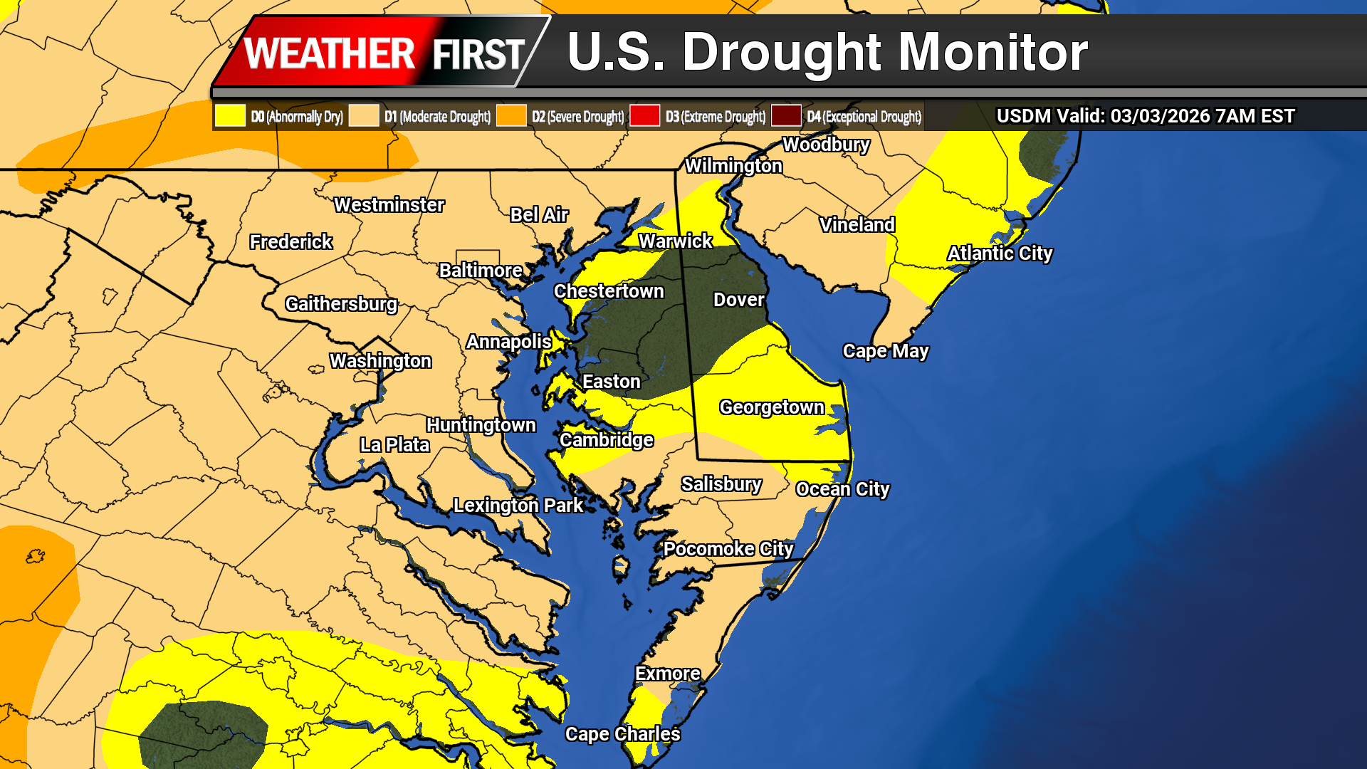
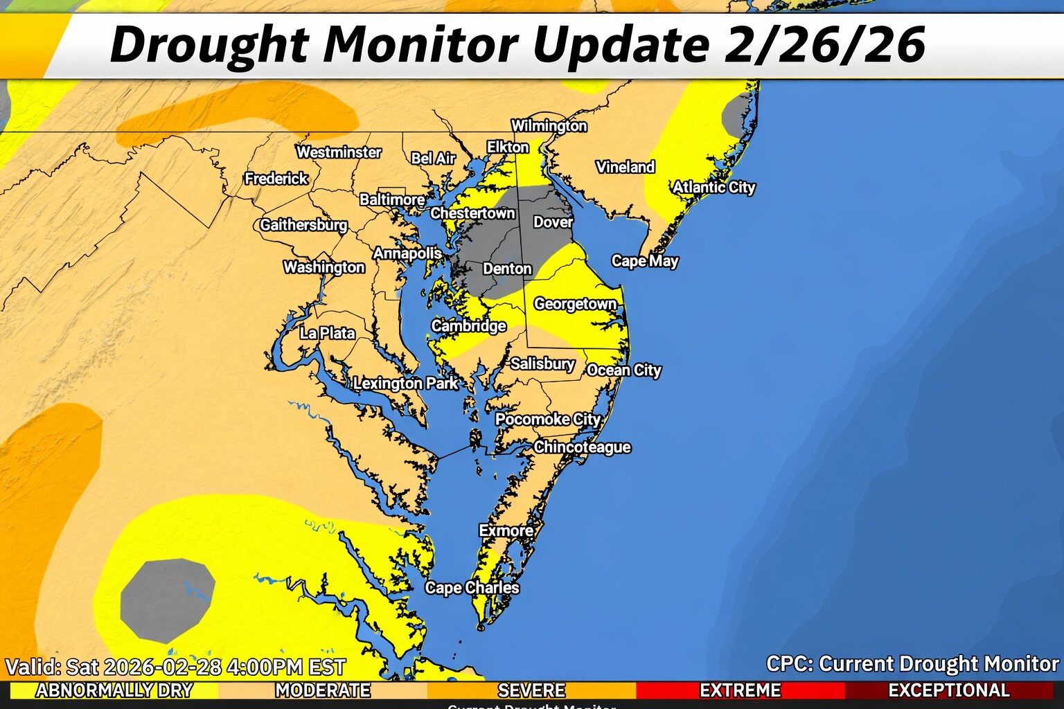
The latest U.S. Drought Monitor, released Thursday, shows drought conditions continuing across portions of the Delmarva Peninsula, although impacts vary depending on location across Delaware, Maryland’s Eastern Shore, and the lower Eastern Shore of Virginia.
According to the newest data, areas of moderate drought (D1) remain across parts of the lower Maryland Eastern Shore and nearby sections of the Mid Atlantic. Meanwhile, other portions of the Delmarva region are classified as abnormally dry (D0), indicating lingering moisture deficits but not yet reaching official drought status.
The U.S. Drought Monitor categorizes drought into several levels, ranging from D0 (abnormally dry) to D4 (exceptional drought). Areas in the D0 category are often experiencing short term dryness or recovering from drought conditions, while D1 indicates more significant moisture deficits that can begin to impact agriculture, water supplies, and ecosystems.
Delmarva Conditions
Across the Delmarva Peninsula, drought conditions have been driven largely by several months of below normal precipitation, which has led to declining groundwater levels, reduced streamflow, and drier soils in some areas. Long term precipitation deficits in parts of Delaware have ranged several inches below normal over the past six months, contributing to the ongoing dryness.
The latest assessment shows the most notable drought conditions focused across portions of the Maryland Eastern Shore, while parts of Delaware and the Virginia Eastern Shore remain mostly in the abnormally dry category or near normal conditions.
Impacts Across the Region
Even moderate drought can have noticeable impacts across Delmarva. Dry soils can affect early season agriculture, groundwater recharge, and local water supplies. In addition, periods of dry and windy weather can increase the risk of brush and vegetation fires, particularly during late winter and early spring when vegetation is dormant.
Officials in parts of the Mid Atlantic have previously issued drought advisories and warnings due to these ongoing dry conditions, especially where streamflow and groundwater levels remain below normal.
Weather forecasters are warning that the season’s first significant severe weather outbreak could impact America’s central regions, placing millions of residents from Texas through Iowa in the path of dangerous tornado activity.
The National Weather Service reported that isolated severe thunderstorms are forecast to develop Thursday evening across the Texas Panhandle, western Oklahoma, and portions of Kansas. Forecasters anticipate these storms will produce large hail, destructive winds, and potentially several tornadoes.
However, Friday is when the most dangerous weather conditions are anticipated across a broad region encompassing much of Oklahoma, Kansas, and Missouri, while extending into adjacent states, weather service forecasts indicate.
The Storm Prediction Center reports that over 6 million Americans face the greatest severe weather threat on Friday, including residents of the Kansas City and Tulsa, Oklahoma metropolitan regions. An additional 22 million people are under a moderate risk level in areas that encompass Oklahoma City, St. Louis, Omaha, Nebraska, and Milwaukee, Wisconsin.
This same weather system driving the severe storm potential will also deliver exceptionally high temperatures for the season by weekend.
“Temperatures will be 20-30 degrees above average, with 80s reaching as far north as parts of the Ohio Valley and Mid-Atlantic,” federal forecasters wrote in their long-range forecast discussion. “Daily records could become widespread.”
City officials in Rehoboth Beach have released comprehensive data about their response to the devastating late February snowstorm that buried the coastal community under more than 18 inches of snow and brought destructive winds. Longtime residents described the weather event as the most severe winter storm they have ever experienced.
Municipal crews have been operating continuously to remove snow accumulation, clear fallen tree branches and debris, and return the community to normal operations. City officials emphasized that these recovery efforts were made possible through the unwavering commitment of municipal employees.
Streets Department Operations
During the height of the storm, the Streets Department deployed 8 crew members working extended 12-hour shifts. The department’s fleet of 9 snow plows operated throughout the city both during and after the snowfall. Crews applied roughly 8 tons of road salt across city streets during the operation.
Emergency Communications Response
The city’s 9-1-1 Communications Center maintained 12-hour shifts throughout the storm period, with 2 to 3 dispatchers cycling through each shift. Between 1 p.m. Sunday and 7 a.m. Tuesday, emergency communications staff handled 370 total calls and managed 90 separate incidents.
Within city boundaries, dispatchers responded to 30 incidents, with 25 of those involving downed trees or power lines. Beyond the city limits, dispatch personnel worked alongside the County Emergency Operations Center and National Guard units to coordinate assistance for calls originating from the Angola region.
Officials indicated they will release additional data regarding tree and debris removal operations once those cleanup efforts are finished.
After a stretch of gloomy and cool weather, a significant warm up is expected to develop across the Delmarva Peninsula this weekend and continue into the first half of next week. Forecasters say temperatures could surge well above normal as a much milder air mass spreads into the Mid Atlantic.
The transition begins later this weekend as a ridge of high pressure builds over the western Atlantic Ocean. At the same time, several upper level disturbances will track across the northern United States, helping to set up a pattern that allows warmer air to gradually move northward into the region.
Before the warmer air fully arrives, cooler conditions may linger into Saturday due to a setup known as cold air damming. Strong high pressure over eastern Canada will push cooler air southward into the region, while a boundary remains positioned to the south and west of Delmarva. This could keep skies cloudy with areas of fog and cooler temperatures early in the weekend.
As the weekend progresses, the colder air mass will begin to erode from south to north. This process may lead to a sharp temperature difference across the region on Saturday before warmer air eventually takes over. Some showers may also develop Saturday night as a disturbance passes to the north and a trailing cold front approaches. A stray thunderstorm cannot be ruled out, although widespread severe weather is not expected.
By Sunday, much of the Delmarva region will become firmly established within the warmer air mass as high pressure settles offshore. Winds shifting to the south and southwest will help draw warmer air northward.
Temperatures are expected to climb into the 60s across much of the region Sunday and Monday. Even warmer conditions are likely by the middle of next week, when highs could reach the low to mid 70s on Tuesday and Wednesday. These readings would be 10 to 20 degrees above average for early March.
Communities along the coast may see somewhat cooler temperatures due to developing sea breezes off the Atlantic Ocean and Delaware Bay. This could keep coastal locations several degrees cooler than inland areas.
The warm pattern may not last indefinitely, however. Forecast models suggest a cold front could approach the region around Wednesday, bringing another chance of showers and potentially preventing temperatures from reaching the warmest projections.
Even so, the overall trend points toward a dramatic shift from recent chilly conditions to a stretch of springlike warmth across the Delmarva Peninsula during the upcoming week.
Governor Matt Meyer has officially proclaimed March 9 through March 13, 2026 as Severe Weather Awareness Week in Delaware, encouraging residents across the First State to prepare for potentially dangerous weather events that can occur throughout the year.
The initiative is led by the Delaware Emergency Management Agency (DEMA) in partnership with the National Weather Service, the University of Delaware’s Center for Environmental Monitoring and Analysis (CEMA), the Delaware Department of Transportation (DelDOT), and Delaware Sea Grant. The goal is to increase awareness about severe weather threats and encourage residents to take steps now to protect their families and communities.
State officials say the week serves as a reminder that Delaware regularly faces weather hazards such as flooding, tornadoes, severe thunderstorms, lightning, and coastal storms. Many of these events can develop quickly, giving residents little time to react without proper preparation.
Daily Severe Weather Safety Topics
Throughout the week, emergency management officials will focus on a different severe weather hazard each day, sharing safety tips and preparedness information.
Monday: Flood safety
Tuesday: Tornado safety
Wednesday: Severe thunderstorms and hail
Thursday: Lightning safety
Friday: Preparing for severe weather
Residents are encouraged to follow along on social media and online resources to learn how to respond when severe weather strikes.
Recent Severe Weather Highlights Need for Preparedness
Delaware has experienced several significant weather events in recent years that highlight the importance of preparedness.
In 2020, the remnants of Tropical Storm Isaias produced the longest tornado ever recorded in Delaware, carving a destructive path from Dover in Kent County to Glasgow in New Castle County. More recently, a tornado in Sussex County in April 2023 resulted in the state’s first tornado-related fatality in decades.
Flooding has also been a growing concern. The remnants of Hurricane Ida produced historic rainfall and flooding in Wilmington in 2021, underscoring the risks associated with extreme weather across the region.
Nationally, severe weather continues to cause major impacts. According to federal climate data, the United States recorded 27 separate billion-dollar weather disasters in 2024, with the majority tied to severe thunderstorms.
Steps Delaware Residents Can Take Now
Emergency management officials say preparedness before severe weather strikes is critical. Residents are encouraged to:
Sign up for alerts through the Delaware Emergency Notification System (DENS)
Build a basic emergency preparedness kit
Create a family emergency plan
Know evacuation zones and local hazards
Stay informed through weather alerts and trusted forecasts
More preparedness information and resources are available at PrepareDE.org.
Officials say even small steps taken ahead of severe weather can significantly reduce risks to lives and property when dangerous conditions develop.
A stretch of gloomy weather is expected to continue across the Delmarva Peninsula through Friday as a stalled frontal boundary keeps the region locked into cool, damp conditions.
The front will remain positioned mostly south of the region, allowing several weak areas of low pressure to move along it. These disturbances will periodically bring light rain or scattered showers while maintaining a very moist air mass over the area.
The first round of rain arrived early Thursday morning, with another wave expected to move through later tonight. Between these periods of rainfall, mist and drizzle are likely to develop, along with areas of fog as light winds and abundant moisture linger across the region.
Patchy dense fog will remain a concern at times through Friday. However, forecasters note that winds may stay just strong enough to prevent widespread dense fog development. Melting snow and warming ground temperatures may also help reduce the risk somewhat, though localized visibility reductions are still possible, particularly during the overnight and early morning hours.
As a result, conditions may remain murky across much of the Delmarva Peninsula with low clouds and periods of reduced visibility.
The unsettled pattern continues into Friday as a backdoor cold front pushes into the region from the north and east before stalling across Delmarva. This setup will trap low-level moisture beneath a temperature inversion, leading to persistent cloud cover along with occasional drizzle, light showers, and areas of fog.
Temperatures will stay on the cool side for early March, with afternoon highs across most of the region expected to remain in the 40s.
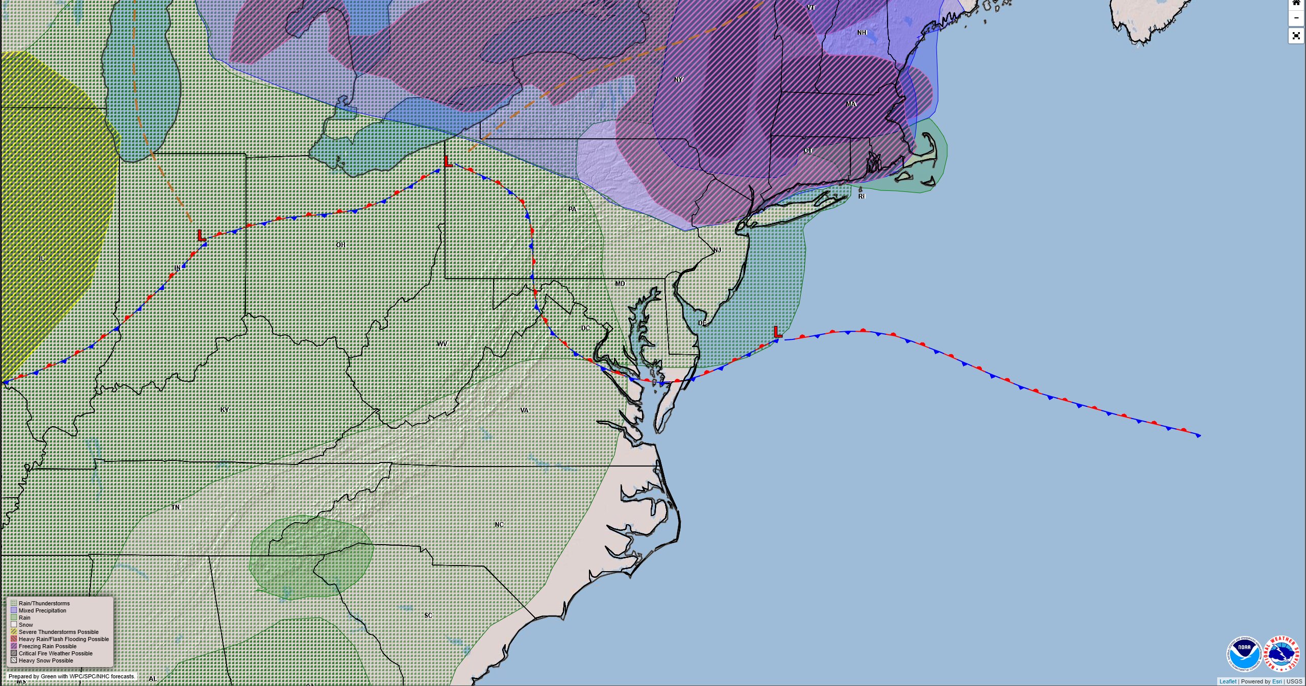
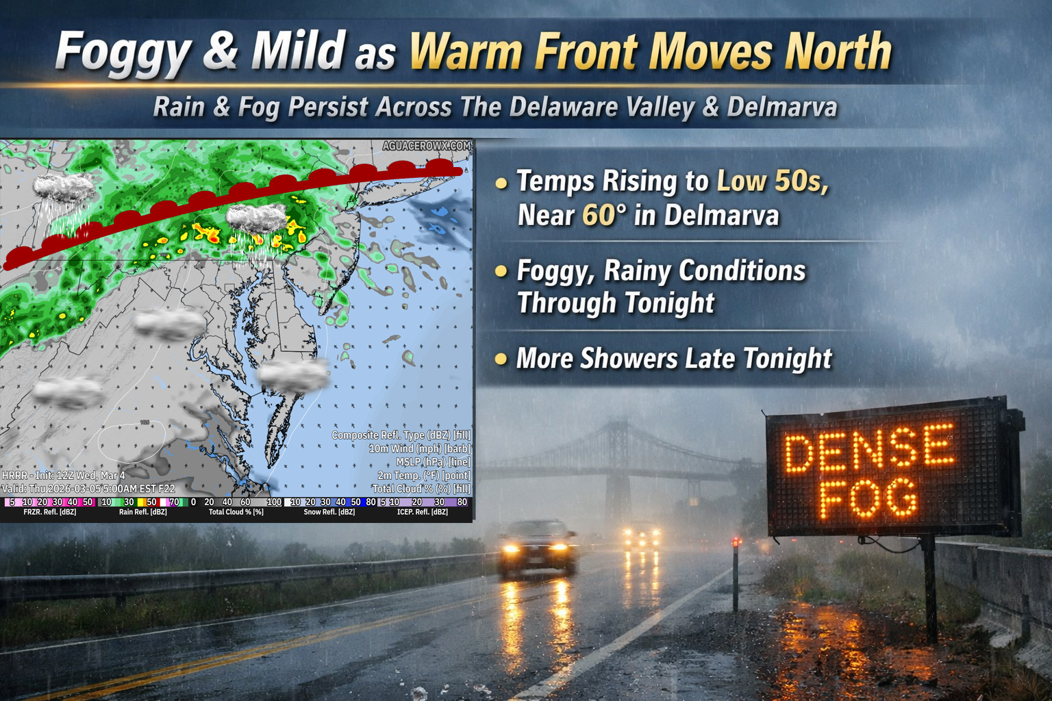
Cloudy, foggy conditions will continue across the Delmarva Peninsula today as a slow moving weather system lifts north through the region. A stationary front currently stretching from low pressure over the Ohio Valley across Delmarva and southern New Jersey will gradually begin to shift northward as a warm front through the day.
As this front lifts north, temperatures across the region will slowly rise. Afternoon highs are expected to reach the low 50s for many areas, with some locations across Delmarva potentially climbing into the upper 50s. Temperatures will remain relatively mild overnight as well, only dropping into the 40s.
Fog has been widespread across the region early today, although visibility has shown some improvement in some areas. Despite this, fog is expected to remain a concern through much of the day, particularly closer to the coast, Delaware Bay, and along the shoreline where it may remain thicker and more persistent. Motorists traveling in these areas should continue to exercise caution due to reduced visibility.
Later this afternoon and into the evening hours, a disturbance in the upper atmosphere combined with weak low pressure moving through the region may trigger scattered showers. The best chance for rain will be across the Delaware Valley, southern New Jersey, and the Delmarva Peninsula. While rainfall amounts are expected to remain relatively light, wet roads could add to the already challenging travel conditions caused by fog.
As the main low pressure system moves closer tonight, fog is expected to redevelop and cloud ceilings will likely lower once again. Another round of light rain may also develop late tonight as the system approaches. Overnight temperatures will remain mild, generally settling into the 40s across the region.
The unsettled and damp conditions are expected to linger into Thursday as the slow moving weather pattern continues to influence the Mid-Atlantic.
Delaware Department of Transportation officials are urging drivers to exercise extreme caution while navigating Stanton Christiana Road due to dangerous flooding conditions affecting the thoroughfare.
The water accumulation on the roadway poses significant safety risks for vehicles attempting to pass through the area. Transportation authorities recommend that drivers reduce their speed considerably and remain alert for changing road conditions.
Those planning to travel through the region should anticipate possible delays and may want to consider alternative routes until the flooding subsides and normal traffic patterns resume.
Weather officials from the National Weather Service Mount Holly office have issued a dense fog advisory for the Delmarva Peninsula, warning residents of significantly reduced visibility conditions Sunday evening.
The advisory went into effect at 4:04 PM on March 3rd and will remain active until 10:00 PM the same day, according to meteorologists.
Drivers are urged to exercise extreme caution while traveling during these conditions, as the thick fog can drastically limit visibility on roadways. Motorists should reduce speeds, use low-beam headlights, and maintain greater following distances between vehicles.
The weather service recommends avoiding unnecessary travel if possible until conditions improve later this evening.
Motorists in Sussex County are encountering foggy conditions of different intensities across the region, according to Delaware Department of Transportation reports.
The weather phenomenon is affecting visibility throughout the county, creating potentially dangerous driving conditions for residents and travelers.
Drivers are advised to exercise caution, reduce speeds, and use low-beam headlights when navigating through areas experiencing reduced visibility due to the fog.
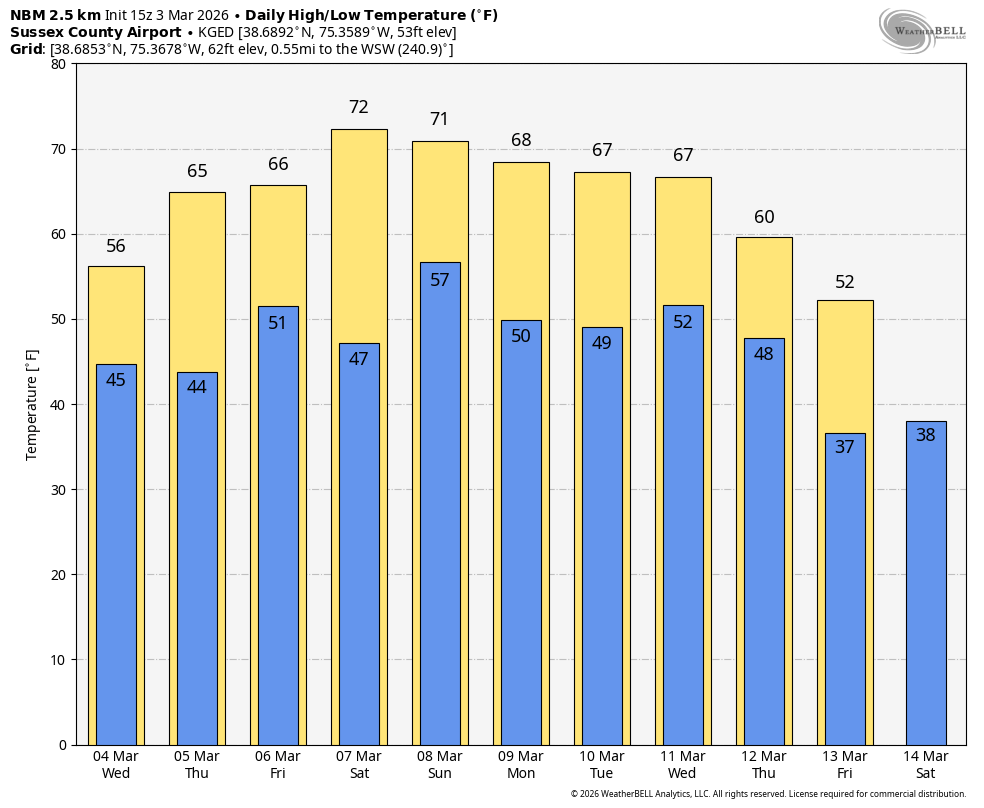
A significant shift in the overall weather pattern is setting the stage for a prolonged warm up across the Delmarva Peninsula beginning mid week and continuing into early next week. An upper level trough developing over the western United States will allow strong ridging to build over the eastern half of the country. As that western trough digs farther south into western Mexico by Friday, the ridge over the East will amplify. At the surface, a large Bermuda high will take control, promoting a milder southwest flow into the Mid Atlantic and pushing temperatures well above average for early March.
By Wednesday, highs across Delmarva will climb into the 50s to near 60 degrees. The forecast becomes more complicated from Thursday through Saturday as a frontal boundary wavers north and south across the region. The front is expected to lift north on Thursday before stalling and then dropping back south as a backdoor front Friday into Saturday. Its exact placement will create sharp temperature differences across relatively short distances. South of the boundary, temperatures will warm into the mid 60s to around 70 degrees, while areas near the front hover around 60. North of the boundary, highs may struggle in the 40s and 50s. There is increasing potential that some parts of Delmarva could trend cooler than currently forecast, particularly if a persistent east to northeast wind develops and pulls in cooler marine air from the Atlantic.
By Sunday and into early next week, the front is expected to lift back north, placing the region firmly in the warm sector once again. Highs should reach the 60s and lower 70s inland. Coastal communities, including areas along the Delaware Beaches and the Maryland and Virginia Eastern Shore, are likely to remain cooler in the 40s and 50s due to the influence of the cold ocean waters.
Although this pattern does not favor any significant storms, it will not be completely dry. The wavering boundary will serve as a focus for several weak disturbances moving through from Wednesday into Saturday, bringing multiple opportunities for showers. A slightly stronger wave Thursday night could even produce a few rumbles of thunder. Shower chances may linger into the weekend and early next week as the jet stream remains displaced well to the north.
Any rainfall that develops will be welcomed across Delmarva, where ongoing drought conditions have left soils dry. While this does not appear to be a soaking event, periodic showers could provide some short term relief as the region transitions toward spring.
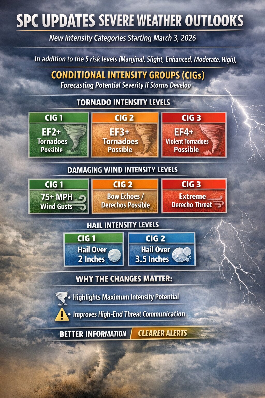
Beginning today, March 3, 2026, the Storm Prediction Center is implementing significant changes to how severe weather risks are communicated in its daily convective outlooks.
The update does not change the familiar five tier categorical system used to describe overall severe weather risk. Instead, it enhances the outlooks by adding clearer information about the potential intensity of tornadoes, damaging winds, and hail, even in situations where storms may be limited in coverage.
The change is designed to improve how forecasters communicate high impact threats and help emergency managers, broadcasters, and the public better understand the severity of possible outcomes.
What Remains the Same
The SPC will continue to issue its well known categorical risk levels: Marginal Level 1, Slight Level 2, Enhanced Level 3, Moderate Level 4, and High Level 5.
These categories still represent the overall probability and expected coverage of severe thunderstorms within 25 miles of a point.
What Is New: Conditional Intensity Groups
The major addition is the introduction of Conditional Intensity Groups, also known as CIGs. These new markers appear within the probabilistic tornado, wind, and hail outlooks and are intended to show the maximum expected intensity of severe hazards if storms develop.
In previous outlooks, hatched areas indicated potential for significant severe weather but did not clearly differentiate between moderate and extreme scenarios. Now, distinct intensity tiers provide clearer hazard messaging.
Tornado Outlook Changes
Tornado forecasts now include three Conditional Intensity Groups.
CIG 1 indicates an environment supportive of tornadoes up to at least EF2 strength.
CIG 2 signals potential for strong tornadoes of at least EF3 intensity.
CIG 3 highlights an environment capable of producing violent tornadoes rated EF4 or stronger.
This is particularly important in conditional setups where storm coverage may be limited but atmospheric parameters strongly favor intense tornadoes. Under the old system, that nuance was more difficult to convey visually. Now, even on days with lower overall probabilities, SPC can communicate when the ceiling for tornado strength is especially high.
Damaging Wind Outlook Changes
Wind outlooks are also receiving expanded intensity detail.
Three wind intensity tiers are now included.
CIG 1 represents potential for gusts of at least 74 miles per hour.
CIG 2 indicates an environment supportive of organized bow echoes or derechos.
CIG 3 highlights an ongoing or highly likely derecho level event.
In addition, SPC is adding higher probability thresholds of 75 percent and 90 percent to Day 1 and Day 2 wind outlooks. These elevated percentages signal very high confidence in widespread damaging wind. This refinement allows forecasters to distinguish between scattered severe gusts and large scale, high impact wind events.
Hail Outlook Changes
Hail forecasts now include two distinct intensity tiers.
CIG 1 indicates potential for hail greater than 2 inches in diameter.
CIG 2 indicates potential for hail exceeding 3.5 inches in diameter.
The addition helps differentiate between typical severe hail events and environments supportive of extremely large, destructive hail often associated with long lived supercells.
Unlike tornado and wind outlooks, hail currently includes two tiers rather than three, reflecting the rarity and forecasting challenges associated with the most extreme hail sizes.
Why the Change Matters
The update enhances SPC’s ability to communicate risk in two critical ways. It separates coverage probability from maximum intensity potential. It also better highlights high end threats in conditional environments.
For emergency planners and broadcast meteorologists, this provides clearer decision support information. For the public, it offers a more precise understanding of how dangerous storms could become, not just how likely they are to occur.
The revised outlook format takes effect with today’s convective outlook issuance and will apply to Day 1, Day 2, and Day 3 severe weather forecasts.
Weather officials have concluded a brief winter weather advisory that affected the Delmarva Peninsula early Sunday morning.
The National Weather Service office in Mount Holly, New Jersey, had put the advisory into effect at 7:51 a.m. on March 3rd, lifting it approximately one hour and nine minutes later at 9:00 a.m. the same day.
The short-duration advisory covered areas under the Mount Holly forecast office’s jurisdiction, which includes portions of Delaware and the surrounding region.
Residents who may have been impacted by the brief weather event can continue monitoring local conditions and official weather service updates for any additional information.
Delaware Department of Transportation officials have implemented a temporary speed limit reduction on Interstate 495, bringing the maximum allowable speed down to 55 miles per hour due to current weather conditions affecting the roadway.
The speed restriction has been put in place as a safety precaution to help motorists navigate the interstate more safely during adverse weather that could impact driving conditions.
Drivers traveling on I-495 are advised to observe the reduced speed limit and exercise additional caution while the weather-related restrictions remain in effect.
Weather officials have issued a winter weather advisory for the Delmarva Peninsula, warning residents of potentially hazardous conditions during the early morning hours.
The National Weather Service office in Mount Holly, New Jersey, activated the advisory at 1:26 AM EST on March 3rd, with the warning set to remain active until 8:00 AM EST the same day.
Local residents are advised to exercise caution during morning travel and stay updated on changing weather conditions throughout the advisory period.
Each year, meteorologists and emergency management officials mark their calendars for the official Atlantic hurricane season, which begins on June 1st and extends through November 30th.
This six-month window represents the period when conditions in the Atlantic Ocean basin are most favorable for tropical storm and hurricane development. During these months, residents along the Eastern Seaboard, including Delaware and the Delmarva Peninsula, monitor weather forecasts closely as storm systems can potentially impact the region.
The established timeframe helps coastal communities prepare for potential severe weather events and serves as a reminder for families to review their emergency preparedness plans.
Weather officials have issued a Winter Weather Advisory for the Delmarva Peninsula, alerting residents to prepare for challenging conditions through Monday morning.
The National Weather Service office in Mount Holly, New Jersey announced the advisory Saturday evening at 8:49 PM, with the warning set to remain in effect until 8:00 AM on Monday, March 3rd.
Local residents should monitor weather conditions closely and take appropriate precautions during the advisory period. The warning suggests that winter weather conditions may create hazardous situations for travel and outdoor activities across Delaware and the surrounding Delmarva region.
Residents are encouraged to stay updated on changing weather conditions and plan accordingly for potential impacts to their Monday morning commute and weekend activities.
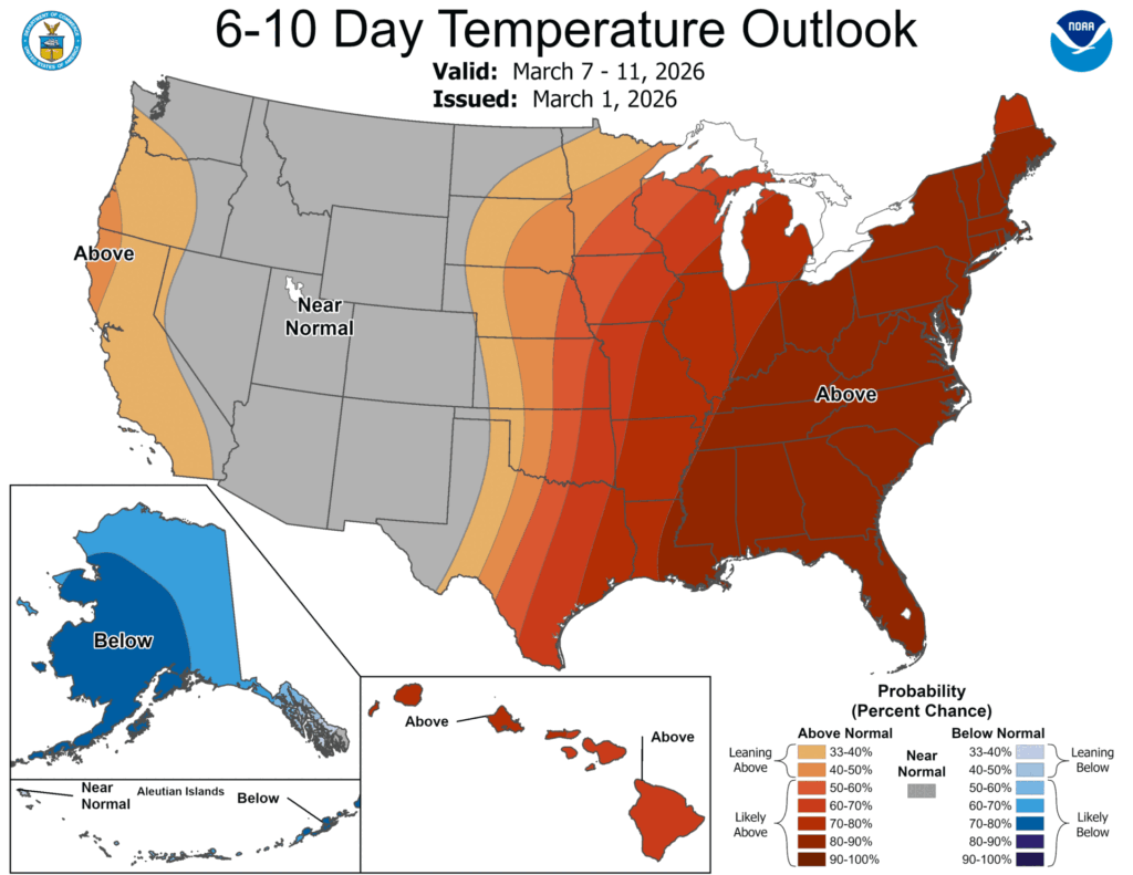
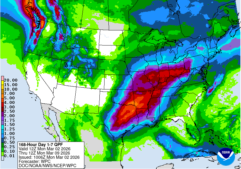
Delaware residents can expect warmer than usual weather in the coming week and a half, according to extended weather forecasts covering the next 6 to 10 days. The projection indicates that most areas across the nation will see temperatures at or above seasonal averages, with rainfall amounts also expected to meet or exceed normal levels.
The East Coast, including Delaware and surrounding states, shows the highest probability for experiencing temperatures warmer than typical for this time of year. Conversely, areas expecting below-average moisture include California and portions of the western Great Basin region.
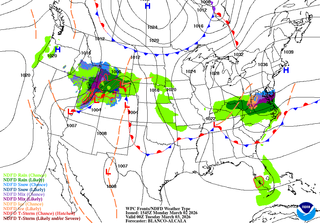
Cold temperatures will begin moving northward this week but will remain present near the Canadian border stretching from North Dakota through New England. Early week weather patterns may bring icy conditions and freezing precipitation to areas as far south as the Ohio Valley and Mid-Atlantic region before milder temperatures take hold.
The weather pattern is expected to shift during the week’s second half, with warmer air masses moving into the region.
Weather officials have put the Delmarva Peninsula under a Winter Weather Advisory that began Saturday afternoon and will remain in effect until Sunday morning at 8:00 AM.
The National Weather Service office in Mount Holly, New Jersey activated the advisory at 1:18 PM on Saturday, March 2nd, warning residents across Delaware and surrounding areas to prepare for winter weather conditions.
The advisory will stay active until 8:00 AM on Sunday, March 3rd, giving local communities nearly 19 hours to navigate the anticipated weather challenges.
Residents throughout the region should monitor local conditions closely and take appropriate precautions for travel and outdoor activities during the advisory period.
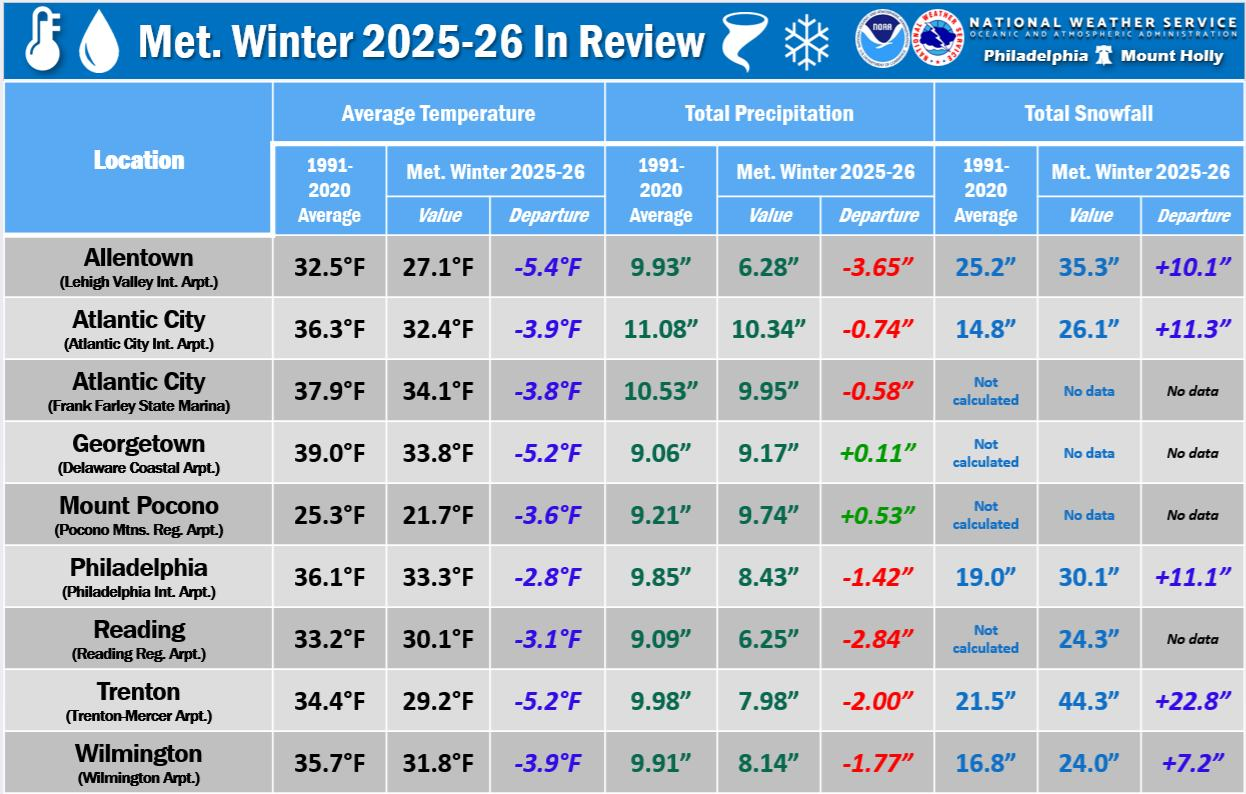
Meteorological Winter 2025–26 will go down as one of the coldest and snowiest winters in over a decade for much of the Mid-Atlantic, including Delaware and the I-95 corridor. While snowfall was impressive, precipitation overall leaned slightly below average in many locations, making it a cold and snowy, but somewhat dry winter season.
Preliminary data from the National Weather Service shows that several cities experienced their coldest winter since the mid-2010s, and in some cases, the early 1990s.
A Historically Cold Winter
Across the region, average temperatures finished several degrees below normal.
In Georgetown, the average winter temperature was 33.8°F, which is 5.2 degrees below normal. This ranks as the 8th coldest meteorological winter since 1893-94, marking the coldest winter there in over three decades.
In Wilmington, the average temperature came in at 31.8°F, or 3.9 degrees below normal, making it the coldest winter since 2014-15.
Philadelphia, Allentown, Trenton, Reading, Mount Pocono, and Atlantic City all saw their coldest meteorological winter since at least 2014-15, while Atlantic City Marina experienced its coldest since the historic winter of 1993-94.
Snowfall: A Major Comeback Year
Snowfall was the headline story this winter, particularly along and north of the I-95 corridor.
In Wilmington, seasonal snowfall reached 24.0 inches, which is 7.2 inches above normal. This makes it the snowiest winter since 2013-14, breaking a decade-long stretch of relatively modest snowfall seasons.
Farther north, Trenton recorded 44.3 inches, ranking as the 6th snowiest winter on record. Philadelphia measured 30.1 inches, its snowiest winter since 2013-14.
Although snowfall data was not calculated for Georgetown’s seasonal totals, February alone brought impactful snow events, and nearby observing sites confirm this winter was significantly snowier than recent years across southern Delaware.
Precipitation: Snowy But Slightly Dry
Despite the frequent snow, total liquid precipitation was generally below normal in many locations.
Wilmington finished with 8.14 inches, about 1.77 inches below average. Georgetown, however, was one of the few spots to edge slightly above normal, finishing at 9.17 inches, just 0.11 inches above average.
This reflects the nature of the season: colder air masses favored snow production, but overall storm systems were not especially moisture-rich.
February Sealed the Deal
February reinforced the winter’s cold theme. Georgetown averaged 5.7 degrees below normal for the month, while Wilmington finished 3.4 degrees below average. Several late-month warmups pushed temperatures near 60 degrees, but they were not enough to offset persistent cold earlier in the season.
America’s agricultural heartland is experiencing dramatically different weather conditions this Monday, creating challenges for residents across multiple states. Bitter cold temperatures have settled over the Corn Belt region, with some areas in the upper Great Lakes recording sub-zero readings during the early morning hours.
Winter storm conditions are creating hazardous travel situations throughout the Ohio Valley and surrounding areas, where a dangerous mix of snow, sleet, and freezing rain is currently falling. Local authorities are reporting travel disruptions as roads become increasingly treacherous.
Further west on the Plains, fire weather concerns persist as conditions remain favorable for wildfire development stretching from portions of eastern Colorado eastward into neighboring states.
Weather officials have issued a special advisory for residents across the Delmarva Peninsula region Saturday morning.
The National Weather Service’s Mount Holly, New Jersey office released the weather statement at 11:34 AM EST on March 2nd, alerting local communities to developing conditions.
The advisory affects areas throughout Delaware and the Eastern Shore of Maryland and Virginia that fall under the Mount Holly forecast office’s jurisdiction.
Residents are encouraged to monitor local weather conditions and stay tuned to TV Delmarva for the latest updates on any changing weather patterns in the region.
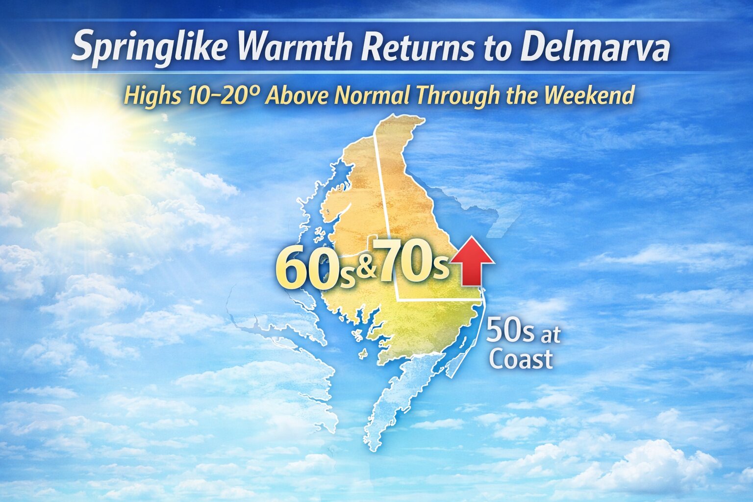
A noticeable pattern change will bring a significant warm-up to the Delmarva Peninsula beginning mid-week and continuing through the upcoming weekend, along with several opportunities for showers. After recent colder conditions, the large-scale setup across the United States is shifting. Upper-level troughing will deepen over the western part of the country while strong ridging builds across the East. At the surface, a large Bermuda high will take control, allowing much warmer air to surge northward into the Mid-Atlantic region.
As a result, temperatures are expected to run 10 to 20 degrees above normal by late week. Highs on Wednesday will climb into the low 50s to low 60s, followed by even warmer readings Thursday, when many areas reach the upper 50s to upper 60s. Some communities across Delmarva could even touch the low 70s. Friday’s forecast is slightly more complicated, as a back-door cold front dropping south from New England may briefly knock temperatures down compared to Thursday. Even so, highs should still reach the low 50s to low 60s, which remains above average for this time of year.
By the weekend, that boundary is expected to lift back north, placing Delmarva firmly back into the warm sector. Inland areas could see highs well into the 60s and 70s on Saturday and Sunday, offering a preview of spring. Coastal communities, however, will likely remain cooler, mainly in the 50s, due to chilly Atlantic water temperatures and occasional onshore flow.
In addition to the warmer air, several weak disturbances will move along a boundary stretched from the Ozarks to New England, bringing multiple chances for showers from Wednesday through the weekend. Rain chances will generally range between 30 and 60 percent during the week. A slightly stronger wave Thursday night may even produce a few rumbles of thunder. Shower chances continue into the weekend, though they appear lower overall, closer to 20 to 40 percent as the jet stream remains positioned well north of the region.
Overall, the pattern does not suggest any major storm systems or significant severe weather at this time. Instead, Delmarva can expect a stretch of well above normal temperatures paired with periodic, beneficial rainfall is welcome news given ongoing drought concerns in parts of the Mid-Atlantic.
Storm debris cleanup efforts are ongoing in Wicomico County as the Department of Public Works assists with roadside debris removal following the recent severe weather that impacted the area.
Officials announced that the brush collection site at the Parsonsburg Convenience Center has reached maximum capacity and will temporarily cease operations. The facility will remain unavailable to residents until county crews can process the accumulated storm debris.
The county’s public works department continues its efforts to help communities recover from the storm damage by supporting cleanup operations throughout the region.
City officials in Rehoboth Beach are advising residents that cleanup operations following recent storm damage will require several weeks to finish completely.
Municipal work crews have deployed collection trucks today to gather storm debris while also handling regular trash collection duties, according to city officials who are asking for public patience during the process.
The Streets Department has established specific guidelines for debris removal that residents must follow. All large pieces of fallen trees and branches must be cut down to sections measuring 4 feet or smaller, or they will be left behind during collection runs.
City workers will not enter private properties to remove debris, making property owners responsible for clearing their own land. However, municipal crews may remove debris that blocks public roads or right-of-way areas.
Residents seeking an alternative disposal method can bring their storm debris directly to the recycling center located at 37540 Oyster House Road. The facility operates from 9 am to 1 pm on Mondays, Fridays, and Saturdays.
Officials emphasized that the cleanup process will require several weeks to complete due to the extensive amount of fallen trees, limbs and branches left behind by the storm.
Arctic high pressure will keep the Delmarva region locked in a stretch of below-normal temperatures through Tuesday, while a developing system to the south brings periods of light wintry precipitation.
Cold Start to the Week
High pressure centered over the eastern Great Lakes will gradually shift offshore tonight and settle over the western Atlantic by Tuesday. In the meantime, Delmarva will remain firmly under a cold air mass.
High temperatures today will struggle to reach the low to mid 30s, running roughly 10 degrees below seasonal averages. Winds will remain light, but the cold air will be firmly entrenched across the peninsula.
Light Snow Developing This Afternoon
As the high slides offshore, a developing area of low pressure over the Southern Plains will push a warm front northward toward the Mid-Atlantic.
Shortwave energy riding along that boundary is expected to trigger light snow across Delmarva this afternoon into early evening. A light coating of snow is possible, especially across the Eastern Shore of Maryland and Delaware. Any snow that develops should taper off later this evening.
Accumulations are expected to remain minor, generally less than an inch.
Wintry Mix Late Tonight into Tuesday
Attention then turns to late tonight into Tuesday morning as the warm front continues lifting north. With temperatures initially below freezing, precipitation will begin as snow across much of Delmarva.
Southern portions of the peninsula are expected to change over to plain rain fairly quickly overnight as slightly warmer air moves in. However, across northern areas of Delmarva, a brief period of wintry mix cannot be ruled out before transitioning to rain.
Any ice accumulation locally would be light, generally a glaze at most, with snowfall totals remaining under one inch.
Milder by Tuesday Afternoon
By Tuesday afternoon, temperatures should rise into the 40s across Delmarva, allowing all precipitation to change to plain rain.
While this is not expected to be a major winter event for the peninsula, brief slick spots are possible late tonight into early Tuesday before the changeover to rain.
Delaware Department of Transportation crews are currently conducting salt brine operations throughout the state, officials announced.
Drivers can expect to encounter slow-moving vehicles on roadways as DelDOT teams apply brine solution to road surfaces. The department is advising motorists to exercise caution and maintain safe following distances when approaching these operations.
The brine application is part of DelDOT’s standard road treatment procedures to help maintain safe driving conditions on Delaware highways and local roads.
Motorists are encouraged to allow extra travel time and remain alert for work crews and equipment operating at reduced speeds during these operations.
Weather officials from the National Weather Service’s Mount Holly, New Jersey office have issued a special weather statement for the Delaware region early Thursday morning.
The weather advisory was released at 4:17 AM Eastern Standard Time on February 28th, according to official records.
Residents across the First State should stay alert for potential weather developments and monitor local forecasts for any updates or changes to conditions.
The National Weather Service continues to track weather patterns affecting the mid-Atlantic region and will provide additional information as conditions warrant.
Delaware Department of Transportation officials have implemented a temporary speed reduction on Interstate 495, dropping the limit to 55 miles per hour due to current weather conditions affecting the area.
The speed restriction has been put in place as a precautionary safety measure to help protect motorists navigating the highway during adverse weather. DelDOT regularly adjusts speed limits on major roadways when weather conditions pose potential hazards to drivers.
Motorists traveling on I-495 are advised to observe the reduced speed limit and exercise additional caution while driving. The temporary speed reduction will remain in effect until weather conditions improve and normal highway speeds can be safely restored.
Dense fog is creating dangerous driving conditions across Delaware today, prompting state transportation officials to issue a safety warning for all motorists.
The thick fog has been spotted at different levels of density throughout the First State, significantly reducing visibility on roadways and making travel more hazardous than normal.
Delaware Department of Transportation officials are urging drivers to take extra precautions while behind the wheel during these challenging weather conditions. Reduced visibility can make it difficult to see other vehicles, road signs, and potential hazards ahead.
Motorists should consider slowing down, increasing following distance, and using low-beam headlights when driving through foggy areas. Drivers may also want to delay non-essential travel until conditions improve.
A cold Arctic air mass will settle over the Delmarva region to start the week, setting the stage for two separate storm systems that could bring periods of wintry precipitation from Monday through Wednesday.
High pressure building south from Canada will lock in colder air across Delaware, Maryland’s Eastern Shore, and coastal Virginia on Monday and Tuesday. That cold air will be critical in determining precipitation type as the first of two systems approaches.
First System: Light Snow Possible Monday
The first wave of low pressure is expected to move east out of the Tennessee Valley on Monday, tracking along a stalled frontal boundary. Current guidance keeps this system somewhat suppressed to the south as it passes near the Chesapeake region.
For Delmarva, this setup could bring a period of light snow later Monday into Monday evening. However, confidence remains limited. Precipitation chances have decreased into the 20 to 40 percent range, and projected snowfall amounts have trended downward in recent forecasts. If snow does occur, it currently appears more likely to be light and limited in duration.
Second System: Higher Rain Chances Tuesday Into Wednesday
Attention then turns to a second disturbance expected to ride along the same boundary late Tuesday into Wednesday. Forecast models show better agreement that this system will impact the region, though some timing differences remain.
Unlike Monday’s system, temperatures are forecast to gradually warm Tuesday into Tuesday night as southerly winds develop. This could allow for a rain and snow mix at the onset, especially Tuesday evening, before transitioning to plain rain overnight into Wednesday.
Precipitation chances with this second system have increased into the 50 to 70 percent range, making it the more likely of the two systems to bring measurable precipitation to Delmarva.
Multiple weather systems moving rapidly across the country will bring continued unsettled conditions to various regions over the coming days, with the southeastern United States expected to bear the brunt of the stormy weather. Meteorologists predict that over the next five days, rainfall amounts could accumulate to between 1 and 2 inches or higher throughout the Southeast, driven by two distinct rounds of wet weather.
Meanwhile, the southwestern portion of the country will experience markedly different conditions, with forecasters calling for predominantly dry weather patterns to dominate the region during the same five-day period.
The National Weather Service office in Mount Holly, New Jersey has issued a special weather statement affecting the Delmarva Peninsula region. The weather advisory was released Wednesday morning at 6:06 AM Eastern Standard Time on February 27th.
Weather officials are monitoring conditions across Delaware and surrounding areas. Residents are advised to stay informed about changing weather conditions and follow any updates from the National Weather Service.
The Mount Holly office regularly issues weather statements and warnings for Delaware, southeastern Pennsylvania, and southern New Jersey. These alerts help keep the public informed about potentially hazardous or noteworthy weather conditions.
TV Delmarva will continue monitoring this developing weather situation and provide updates as they become available from the National Weather Service.
Delaware transportation officials have shut down a section of Pickwicke Road after trees fell across the roadway, blocking traffic in both directions.
The complete closure extends from Fairfield Road to Harris Road, with DelDOT crews working to clear the debris and reopen the route to motorists.
Drivers are being advised to find alternate routes while crews work to remove the fallen trees and restore normal traffic flow. No timeline has been provided for when the road will reopen.
Rehoboth Beach officials have canceled this weekend’s Special Olympics Delaware Polar Bear Plunge, citing safety concerns as the city continues recovering from a major snowstorm.
City leaders made the difficult decision after determining that ongoing cleanup operations and hazardous conditions would prevent them from safely hosting the popular annual event.
Several factors influenced the cancellation decision, according to city officials. Many sidewalks throughout the community remain uncleared, forcing large crowds to walk in roadways. Snow continues to blanket the boardwalk and beach access points through the dunes remain blocked.
Emergency services would face significant challenges with limited parking and staging areas unavailable, while the event requires public safety teams to be fully prepared. City work crews remain focused on helping residents who lost electricity, have restricted street access, and are dealing with fallen trees and branches on their properties.
Municipal teams are also prioritizing the clearing of Rehoboth Avenue and nearby streets to restore parking availability and business access. The large-scale nature of the Polar Bear Plunge typically requires additional emergency personnel from across the state, but those crews are currently engaged in storm recovery and rescue operations throughout the region.
“Unfortunately, we cannot justify putting people’s safety at risk, nor can we shift our resources to focus on the event,” says Rehoboth Beach Police Chief Keith Banks. “Public works and public safety crews in the city and the surrounding areas have been working around the clock this week, so preparing and staffing the event isn’t feasible this weekend. This timing is unfortunate for all of us, as the Polar Bear Plunge is a wonderful event that we enjoy participating in every year, but we need to put safety first and utilize our resources properly.”
Although weekend weather forecasts show improvement, officials needed to make an immediate decision, and current conditions prevented them from confidently ensuring participant safety and event quality.
“The Polar Bear Plunge is an event we all look forward to in the City of Rehoboth Beach, so this decision did not come lightly,” says City Manager Taylour Tedder. “It needs to be rather extreme circumstances for us to make a recommendation like this, and this storm presented those extreme circumstances. We are proud of the hard work our city employees have done during this storm recovery, including trying their best to make way for the event to happen, but we have simply run out time, as a decision had to be made. We encourage people to continue to support the amazing efforts of Special Olympics Delaware, we appreciate our partnership with them and look forward to welcoming all plungers back here when it’s safer to do so.”
The latest U.S. Drought Monitor update shows that drought and dry conditions remain a concern across much of the Mid-Atlantic region, with impacts continuing for agriculture, water resources and ecosystems.
While the national map shows pockets of improvement in some areas, large portions of the Mid-Atlantic remain classified at various levels of dryness and drought. The drought map uses a five-category scale from D0 (abnormally dry) to D4 (exceptional drought) to characterize conditions.
In the current monitoring period, significant parts of the region, including segments of Maryland, Virginia, Pennsylvania, and surrounding states, are still experiencing at least abnormally dry (D0) conditions. Some locales continue under moderate drought (D1) or more severe classifications, indicating lingering moisture deficits and reduced soil and streamflow conditions.
Precipitation over recent weeks has been below average, leading to limited relief from long-term dryness. Although brief rain events have occurred, they have not been widespread or persistent enough to significantly improve drought conditions across much of the watershed.
Experts note that conditions vary locally, and short-term rains may bring modest improvement in some areas. However, until more widespread rainfall occurs, drought and dryness are likely to persist for much of the Mid-Atlantic.
The U.S. Drought Monitor is updated weekly, typically each Thursday, with conditions valid through the preceding Tuesday morning. The next update will provide a fresh snapshot of any changes in the region’s drought status.
Multiple weather systems moving rapidly across the country will continue to bring changeable conditions to various regions, with the southeastern United States expected to bear the brunt of the activity. Agricultural areas in the Southeast could see significant precipitation over the coming five-day period, with rainfall amounts potentially reaching 1 to 2 inches or higher due to two distinct weather events moving through the region.
Meanwhile, agricultural producers in southwestern portions of the country can expect markedly different conditions, with dry weather patterns expected to dominate the five-day forecast period in those areas.
Uncertainty remains in the forecast as meteorologists monitor the potential for another area of low pressure to impact the Delmarva region early next week.
Following the passage of a strong Arctic front, fresh cold air will be firmly in place across Delaware and Maryland’s Eastern Shore. With that colder air mass established, any developing system Monday into Tuesday could bring another round of wintry weather to the region.
Forecast models continue to struggle with the exact placement and timing of key upper-level features, which is leading to lower confidence in specific details at this time. However, the latest National Blend of Models (NBM) guidance indicates a 50 to 70 percent chance of measurable snowfall somewhere across the region between Monday and Tuesday.
At this point, it remains too early to determine potential snowfall amounts, exact timing, or precipitation type. Small shifts in the storm track or upper-level energy could significantly influence impacts across Delmarva.
Residents are encouraged to monitor forecast updates over the coming days as models come into better agreement and confidence increases.
A fallen tree has forced authorities to shut down North Aquarius Way at its intersection with Cave Neck Road, according to the Delaware Department of Transportation.
The tree has completely blocked the roadway, making it impassable for vehicles traveling through the area. DelDOT officials are monitoring the situation as crews work to address the obstruction.
Motorists are advised to seek alternate routes until the roadway can be cleared and reopened to traffic. No timeline has been provided for when the road closure will be lifted.
A section of Mill Creek Road near Ramunno Circle remains blocked to traffic after trees fell across the roadway, according to the Delaware Department of Transportation.
The road closure is affecting the intersection of Mill Creek Road and Ramunno Circle, preventing vehicles from passing through the area. DelDOT crews are responding to remove the fallen trees and restore normal traffic flow.
Motorists are advised to seek alternate routes while cleanup efforts are underway. No timeline has been provided for when the roadway will fully reopen.
Delaware Department of Transportation officials have shut down a section of Gull Point Road after a tree fell across the roadway.
The closure affects the stretch of Gull Point Road near its intersection with Sylvia Drive, where the fallen tree is blocking traffic in both directions.
DelDOT crews are working to remove the tree and reopen the road to normal traffic flow. Motorists are advised to seek alternate routes while the cleanup operation continues.
No timeline has been provided for when the road will reopen to vehicle traffic.
Delaware transportation officials have shut down a section of Birch Knoll Road after a tree fell across the roadway, blocking traffic in both directions.
The road closure is in effect at the intersection of Birch Knoll Road and Stone Crop Road, where the fallen tree is preventing vehicles from passing through the area.
Motorists are advised to find alternate routes while crews work to remove the tree and reopen the roadway. No timeline has been provided for when the road will be cleared and traffic can resume normal flow.
DelDOT continues to monitor the situation and will update drivers once the obstruction has been removed and the road is safe for travel.
PROVIDENCE, R.I. — Electrical outages, towering snow drifts reaching waist-deep levels, and additional flurries continued to plague Northeast communities Wednesday following a historic winter storm that blanketed the region from Maryland through Maine with massive accumulations of snow and ice.
The storm’s impact continued to disrupt daily life throughout the area: Rhode Island residents faced their third consecutive day trapped in homes as neighborhood roads stayed impassable, garbage collection services were delayed across multiple communities, and educational institutions shifted to remote learning after receiving 3 feet of snowfall that exceeded records established during the legendary 1978 blizzard.
Electrical service remained disrupted for over 138,000 customers Wednesday afternoon, with Massachusetts bearing the brunt of outages, especially throughout Cape Cod, data from poweroutage.us showed. Energy company workers maintained 18-hour work schedules to reconnect service while residents sought refuge in emergency warming facilities to stay warm and charge electronic devices.
Anny Enos brought her three grandchildren to a warming facility in Barnstable, Massachusetts, Wednesday to power up their electronics and escape their cold home. Without electricity since Sunday afternoon, she worried restoration might not occur until Friday.
After discarding most refrigerated items Tuesday, she remained hopeful for the best outcome.
“I hate to say it but it doesn’t seem like they were ready,” she said.
The winter weather event generated “thousands” of locations requiring repair work that demanded crews use heavy machinery to clear massive snow accumulations before installing replacement utility poles or fixing existing infrastructure, explained Doug Foley, president of electric operations for Eversource in Massachusetts. Additional repair teams from neighboring states arrived Wednesday to assist recovery efforts.
Adding to difficulties, an unwelcome additional 3 inches of snow accumulated early Wednesday, worsening hazardous travel conditions before rising temperatures created slushy road surfaces.
This week’s enormous snowstorm has municipal crews working extended hours to remove towering accumulations.
New York City Mayor Zohran Mamdani implemented innovative solutions: beyond distributing 143 million pounds of road salt by Tuesday evening, city officials recruited approximately 3,500 individuals as temporary snow removal workers, paying $30 hourly to clear transit stops and roadways.
Authorities reported that carbon monoxide exposure claimed the life of a man in a Rhode Island community that had lost electrical service. Joseph Boutrous, 21, had informed a Salve Regina University classmate about plans to charge his phone inside his vehicle, Newport Police Capt. Joseph Carroll stated. Snow blocking the exhaust system caused the accidental death of the sophomore from Bohemia, New York, who played offensive line for the football team. Social media messages indicated his teammates were devastated by the loss.
Significant cleanup work remained ahead. New York areas have residents feeling isolated, according to Jeff Peters, spokesperson for the Center for Independence of the Disabled, New York.
“You’ll find a portion of a sidewalk that is clear, and then there’s maybe a 6-inch pathway that can only be walked with one foot in front of the other and no room for a stroller, rollator, walker or crutches,” Peters said. “Then you get to the corner and not only is it unshoveled, but you have basically a glacier at the end of it.”
Tina Guenette, who relies on a motorized wheelchair, spent time this week clearing snow from her property after more than 33 inches accumulated in Harrisville, Rhode Island, located approximately 17 miles northwest of Providence.
“I really have no choice if my service dog wants to go outside,” Guenette said. Harrisville’s volunteer snow-shoveling program hasn’t had volunteers for years, she said.
Monday’s weather system covered the region with heavy snowfall, grounded aircraft, interrupted public transportation, and toppled electrical infrastructure.
Analyzing the storm’s scope, meteorologist Ryan Maue, former chief scientist at the National Oceanic and Atmospheric Administration, determined the total snowfall contained approximately 2.5 trillion gallons of water equivalent.
If all accumulation from Maryland to Maine had fallen exclusively on Manhattan, it would have created a pile exceeding one mile in height. Concentrated solely on Rhode Island, the hardest-hit state, the snowfall would have buried the entire Ocean State under more than 92 feet, The Associated Press calculated.
In liquid form, the amount could fill the Empire State Building with water over 9,000 times. New York State received water equivalent to 680 billion gallons, Pennsylvania accumulated 410 billion gallons, and Massachusetts collected 28 billion.
Eventually, the melting snow will help address drought conditions affecting Northeast regions, Maue noted, though currently it’s compounding difficulties during an already challenging winter season.
“I think this storm took a severe winter and turned it into an extreme winter or a record extreme winter,” he said.
New York City crews established large heated water basins where substantial amounts of snow and ice will be deposited for melting, acting Sanitation Commissioner Javier Lojan announced. These facilities processed 23 million pounds of snow during last month’s winter storm.
Snow-covered Providence, Rhode Island, is transporting accumulations to five designated sites, with additional disposal locations potentially being established, according to Josh Estrella, communications director for city government.
Several major school districts resumed classroom instruction Wednesday, including Philadelphia, which had conducted online education during the week’s first two days. Boston schools reopened following closure since last week’s winter vacation period. However, in severely affected Rhode Island, Providence schools remained closed for a third day as the district implemented “virtual learning” Wednesday.
New York City maintained regular school operations for more than 900,000 students in the nation’s largest public education system, though many students and families navigated enormous snow barriers and avoided salt-spreading vehicles during morning arrival.
Thousands of flights throughout the United States faced cancellation in recent days. By Wednesday, travel disruptions appeared to decrease, with nearly 200 flights grounded, flight tracking website FlightAware reported. Rhode Island’s T.F. Green International Airport resumed operations Tuesday. Some Wednesday flights departed while others were canceled.
When Jamie Meyers’ flight touched down in New York from Buenos Aires, Argentina, Tuesday evening, the cabin filled with relieved passengers who broke into applause. The Manhattan resident had originally planned to arrive home Sunday but experienced a cancellation and substantial delay.
After a stretch of winter chill across the region, the long range outlook is signaling a noticeable shift in the overall pattern heading into early March. The Climate Prediction Center’s 6 to 10 day and 8 to 14 day outlooks both favor above average temperatures across much of the eastern United States, including the Delmarva Peninsula.
Temperatures Trending Above Average
For the 6 to 10 day period, Delmarva sits on the edge of the warmer pattern, but still leans toward above normal temperatures. While the strongest warmth is centered over the Plains and Midwest, milder air is expected to expand eastward into the Mid-Atlantic.
By the 8 to 14 day timeframe, confidence increases that much of the East Coast, including Delaware, Maryland’s Eastern Shore, and coastal Virginia, will see above average temperatures. This suggests a sustained stretch of milder weather heading into the first week of March.
For this time of year, average highs are typically in the mid to upper 40s across much of Delmarva. If this pattern verifies, temperatures could frequently climb into the 50s, with even warmer afternoons possible on select days.
The overall setup points toward a reduced risk of prolonged Arctic intrusions and a lower likelihood of significant winter weather systems during this period.
Precipitation Outlook: Near to Slightly Above Normal
When it comes to precipitation, the signal is more subtle for Delmarva.
In the 6 to 10 day outlook, the wetter pattern is focused mainly across the central United States. Delmarva trends closer to near normal precipitation during this timeframe.
Heading into days 8 to 14, the peninsula remains near normal overall, though there are hints of slightly above average precipitation nearby across portions of the Mid-Atlantic and Ohio Valley. That means we cannot rule out periodic rain chances, but there is no strong signal for an especially wet or dry stretch at this time.
Given the expected milder temperatures, any precipitation that does occur would favor rain rather than wintry weather.
Municipal operations in Salisbury will remain suspended on Tuesday, February 24, despite the end of the official State of Emergency declaration, as electrical service disruptions continue to affect city facilities.
Officials have postponed the scheduled City Council session that was set to begin at 6 p.m. on February 24th because power remains out at the Government Office Building. City leaders say they will inform residents about rescheduled agenda matters when details become available.
Residents with questions can reach the City Clerk’s office by calling 410-548-3140.
The Salisbury Zoo will continue its closure during this period.
Regular collection of trash and recycling will proceed as planned on Tuesday.
Residents who receive municipal water service and require emergency water shut-off can contact Salisbury Police Department’s non-emergency number at 410-548-3165.
Additional details about snow clearing operations and ongoing storm-related updates are available at https://salisbury.md/ or through the city’s Facebook and Instagram social media accounts.
Traffic is being rerouted around a section of Faulkland Road near East Oakland Drive after a tree fell across the roadway.
The Delaware Department of Transportation reports the intersection remains impassable while crews work to remove the fallen tree and restore normal traffic flow.
Motorists should seek alternate routes and expect delays in the area until the roadway reopens.
Rehoboth Beach officials announced they cannot provide a timeframe for when snow will be cleared from public street parking spaces as city workers focus on more urgent storm recovery tasks.
Municipal crews are currently prioritizing the removal of fallen trees, supporting Delmarva Power’s efforts to restore electricity, and providing assistance for the Polar Plunge event following the significant snowfall that hit the area.
City officials acknowledged the importance of street parking availability to residents and visitors, stating they will address snow removal from these areas once higher-priority storm response duties are completed.
The city expressed appreciation for residents’ understanding during recovery efforts from what they described as an unprecedented winter weather event.
After a milder stretch this weekend, another potential system could bring a renewed chance of wintry weather to the Delmarva region early next week.
Milder Weekend Ahead
In the wake of Thursday night’s system, temperatures will moderate across Delaware and Maryland’s Eastern Shore. Highs are expected to climb into the 40s Friday through Sunday, with some locations possibly reaching the lower 50s on Saturday.
This brief warmup should help melt portions of the existing snowpack across the region, especially in areas that received measurable snowfall earlier this week.
Cold Air Returns Late Sunday
A cold front is expected to sweep through later Sunday, ushering colder air back into Delmarva just as we head into the start of the new week.
Forecast guidance suggests a wave of low pressure may ride eastward along this boundary on Monday. With fresh cold air in place, this setup could support another round of wintry precipitation.
Uncertainty Remains
However, confidence remains low at this time. Not all forecast models show a well-developed system. Some solutions depict a weaker and drier disturbance with limited impacts, while others suggest a more organized system capable of producing more widespread precipitation.
If the system does materialize, it currently appears more likely to be a typical winter event rather than a major storm. At this stage, there are no indications of a significant or high-impact system for Delmarva.
We will continue to monitor model trends over the coming days as details regarding track, timing, and precipitation type become clearer.
Stay tuned for updates as we move closer to early next week.
A developing area of low pressure is expected to slide west to east just south of the Delmarva region Thursday into Thursday night, bringing another round of unsettled weather to the area.
While colder air will be in place behind Wednesday morning’s departing system, the latest forecast trends continue to push this upcoming storm track slightly farther south. That shift reduces the likelihood of any meaningful wintry weather across Delmarva.
Mainly Rain for Delaware and the Eastern Shore
At this time, temperatures across Delaware and Maryland’s Eastern Shore look warm enough to support primarily plain rain throughout the event. Unlike areas farther north, where a rain and snow mix is possible, Delmarva is expected to remain on the milder side of the system.
Rain chances will increase Thursday, continuing into Thursday night before tapering off as the system exits offshore.
Little to No Snow Expected
Forecast guidance suggests that if any wintry precipitation were to occur locally, it would be very limited. Current projections show only a trace to a few tenths of an inch of snowfall in areas where mixing might briefly occur, and even that appears increasingly unlikely for most of Delmarva.
Overall, this system currently looks to be a minor event with no significant travel impacts expected at this time.
Utility crews made significant progress overnight, restoring power to an additional 5,000 homes and bringing total restoration to 95 percent of customers impacted by the recent storm.
As of Wednesday morning, approximately 2,800 homes across the service territory remain without power. Officials say crews from across the Mid-Atlantic region are back in the field for extended 16-hour shifts as efforts continue to safely restore service to the remaining customers.
Additional assistance has arrived from Rappahannock Electric Cooperative, Mecklenburg Electric Cooperative, Northern Neck Electric Cooperative, along with local contractors and tree crews. Utility leaders expressed gratitude for the outside support, noting the collaboration has been critical in accelerating restoration efforts.
Crews are hopeful that power will be restored to another 1,000 to 2,000 homes by late tonight, with full system restoration expected sometime Thursday.
Despite substantial progress, widespread damage remains across Kent and Sussex Counties. Hundreds of homes are still affected by fallen trees and debris tangled in power lines, requiring crews to carefully clear hazards before repairs can be completed.
Customers who experience a new outage are encouraged to report it by calling 855-332-9090 or by using the utility’s online outage reporting portal. Officials note that those who have already reported an outage do not need to do so again. A live outage map remains available online to track restoration progress.
Utility representatives described this as the most severe storm to impact the system in more than 30 years. While many customers have been without power for several days, officials say they have been encouraged by the patience and support shown by the community.
Crews will continue working around the clock until every remaining home has service restored. Another update is expected later today.
Recovery operations are ongoing throughout Mid-Atlantic and northern Atlantic coastal areas hammered by recent blizzard conditions, though more than 250,000 Massachusetts residents continue dealing with power outages. At the same time, weather concerns are now turning toward the Pacific Northwest, where northwestern California and southwestern Oregon face the prospect of significant rainfall accumulations of 1 to 4 inches expected to continue through tonight.
Delaware motorists should expect delays on Water Street near Clendaniel Pond Road where a fallen tree is currently blocking the roadway.
The Delaware Department of Transportation reported the obstruction and is working to address the traffic disruption in the area.
Drivers are advised to seek alternate routes while crews work to remove the tree and restore normal traffic flow to the affected section of Water Street.
Weather officials have issued a special advisory for the Delmarva Peninsula region early Monday morning, alerting residents to changing conditions across the area.
The National Weather Service’s Mount Holly, New Jersey office distributed the weather statement at 5:07 AM Eastern Standard Time on February 25th, providing updated information for local communities throughout Delaware and the surrounding region.
Residents are encouraged to monitor local weather conditions and stay informed about any developing situations that may impact travel or daily activities in the coming hours.
The National Weather Service issued a weather advisory for the Delmarva Peninsula early Tuesday morning, alerting residents to monitor current atmospheric conditions.
Weather officials from the Mount Holly, New Jersey forecast office released the advisory at 12:56 AM EST on February 25th, covering areas throughout Delaware and the surrounding region.
Residents across the peninsula should stay informed about developing weather patterns and take appropriate precautions as conditions warrant.
The weather service continues to monitor the situation and will provide updates as new information becomes available.
The National Weather Service office in Mount Holly, New Jersey issued a special weather statement for the region during the early morning hours of February 25th at 12:56 AM Eastern Standard Time.
Weather officials released the advisory to keep area residents informed about current atmospheric conditions and potential weather developments that may affect the region.
The Mount Holly NWS office serves as the primary weather forecasting center for Delaware and surrounding areas, providing critical weather information and alerts to help keep communities safe and prepared.
Residents are encouraged to stay updated on current weather conditions and any additional advisories that may be issued by monitoring official National Weather Service communications.
Cities throughout the Northeast are racing against time to remove massive snow accumulations left behind by this week’s historic blizzard, which buried communities from Maryland to Maine under towering drifts that show little sign of natural melting.
The colossal winter storm deposited enormous amounts of snow across the region, with communities now facing the daunting task of clearing mountainous piles that have created significant challenges for residents and emergency services alike.
New York City deployed extraordinary measures in response, distributing 143 million pounds of salt by Tuesday evening and recruiting over 3,500 emergency snow removal workers at $30 per hour, according to Mayor Zohran Mamdani. These crews are working to clear public roadways and transit stops throughout the city.
However, with forecasters predicting another weather system moving in Wednesday, significant work remains ahead, particularly regarding accessibility concerns for individuals with mobility challenges.
Jeff Peters from the Center for Independence of the Disabled, New York, painted a stark picture of conditions throughout the city, describing many areas as isolated and unreachable.
“You’ll find a portion of a sidewalk that is clear, and then there’s maybe a 6-inch (15-cm) pathway that can only be walked with one foot in front of the other and no room for a stroller, rollator, walker or crutches,” Peters said. “Then you get to the corner and not only is it unshoveled, but you have basically a glacier at the end of it.”
In Harrisville, Rhode Island, located approximately 17 miles northwest of Providence, Tina Guenette faced the challenge of clearing her property despite using a motorized wheelchair after more than 33 inches accumulated in her area.
“I really have no choice if my service dog wants to go outside,” Guenette said Tuesday. She noted that while Harrisville operates a volunteer snow removal program, no volunteers have participated in recent years.
Weather forecasters issued warnings about an additional storm system originating from the Great Lakes region that could impact the Northeast on Wednesday. This clipper system threatens to bring a mix of precipitation including rain and snow, though meteorologists expect it to be considerably less severe than Monday’s event.
NYC Emergency Management cautioned Wednesday morning travelers that predicted light snowfall combined with freezing temperatures could create hazardous conditions on roadways and walkways, including dangerous black ice formation.
Monday’s devastating storm blanketed the entire region, forcing flight cancellations, disrupting public transportation, causing widespread power outages, and claiming at least one life. Rhode Island experienced accumulations exceeding 3 feet, surpassing totals recorded during the legendary Blizzard of 1978, according to National Weather Service data.
Former National Oceanic and Atmospheric Administration chief scientist Ryan Maue provided perspective on the storm’s magnitude, calculating that if all snow that fell between Maryland and Maine had been concentrated solely on Manhattan, the accumulation would have reached over one mile in height.
In Newport, Rhode Island, authorities discovered 21-year-old Joseph Boutros unconscious inside a snow-covered vehicle Monday night, according to local police reports. The Salve Regina University student was transported to a medical facility where he was pronounced deceased due to carbon monoxide poisoning.
Educational institutions began resuming normal operations Wednesday, with major districts like Philadelphia returning to in-person instruction after switching to remote learning during the first two days of the week.
New York City’s public school system, serving more than 900,000 students nationwide’s largest, maintained regular scheduling Tuesday. Students and families navigated enormous snow banks and avoided salt-spreading equipment during morning arrival times.
Electrical service has been restored for many among the hundreds of thousands who lost power across Massachusetts, New Jersey, Delaware and Rhode Island. However, approximately 173,000 Massachusetts customers remained without electricity early Wednesday.
Air travel disruptions affected thousands of flights entering and departing the United States over recent days. By Wednesday, the situation appeared to be improving with only about 150 cancellations recorded, according to FlightAware tracking data.
Manhattan resident Jamie Meyers experienced the travel chaos firsthand when her flight from Buenos Aires, Argentina finally arrived Tuesday evening, prompting relieved passengers to break into spontaneous applause. She had been scheduled to return home Sunday but faced cancellation and substantial delays.
The National Weather Service classified Monday’s weather event as a “classic bomb cyclone/nor’easter off the Northeast coast.” This meteorological phenomenon occurs when atmospheric pressure drops by a specific amount within a 24-hour timeframe.
The National Weather Service office in Mount Holly, New Jersey issued a special weather advisory this evening at 7:02 PM Eastern Standard Time for the Delmarva region.
The weather statement was distributed through the National Weather Service alert system and affects areas under the Mount Holly office’s jurisdiction, which includes Delaware and portions of the surrounding Mid-Atlantic region.
Residents across the Delmarva Peninsula should monitor local weather conditions and stay updated on any developing weather situations in their area.
The National Weather Service Mount Holly office serves Delaware, southeastern Pennsylvania, southern New Jersey, and parts of Maryland’s Eastern Shore with weather forecasts, warnings, and advisories.
The National Weather Service office in Mount Holly, New Jersey has issued a special weather statement affecting the Delaware region this evening.
The weather alert was released at 7:02 PM EST on February 24th to provide updated information about current atmospheric conditions in the area.
Residents across Delaware and surrounding areas should monitor local weather conditions and stay tuned to TV Delmarva for the latest updates on any developing weather situations.
The Mount Holly National Weather Service office regularly issues these statements to keep the public informed about significant weather patterns that may impact daily activities or travel plans.
The National Weather Service office located in Mount Holly, New Jersey issued a special weather advisory on Sunday evening for areas under their forecast responsibility.
The weather statement was released at 5:05 PM Eastern Standard Time on February 24th, alerting residents in the coverage area to monitor conditions.
Residents should stay tuned to local weather updates and follow guidance from the National Weather Service as conditions develop.
SMYRNA, Del. – Governor Matthew Meyer has officially lifted Delaware’s state of emergency declaration that was put in place following this past Sunday’s winter weather event. The emergency status was terminated as of Tuesday, February 24, 2026, at 5:00 p.m.
Along with ending the emergency declaration, the governor has also released Delaware National Guard personnel who were activated to assist with storm response efforts. The emergency declaration was originally activated at noon on Sunday, February.
The state of emergency had allowed for coordinated response efforts and resource deployment throughout the First State as officials worked to address winter storm impacts across Delaware communities.
The National Weather Service office in Mount Holly, New Jersey has released a special weather advisory for the Delmarva Peninsula region this afternoon.
The alert was distributed on February 24th at 4:36 PM Eastern Standard Time, targeting areas under the Mount Holly forecast office’s jurisdiction, which includes Delaware and portions of the Eastern Shore.
Weather officials are advising residents across the region to remain vigilant regarding potential weather developments and to continue monitoring local forecasts for any updates or changes to current conditions.
TV Delmarva meteorologists will continue tracking this situation and provide updates as new information becomes available from the National Weather Service.
Two emergency shelters that opened during recent severe weather conditions have now shut down as recovery efforts move forward across Delaware.
The emergency shelter that was operating at Dover High School ceased operations at 11:30 this morning, while the shelter housed at Sussex Central Middle School in Georgetown closed its doors at 1:30 this afternoon.
Although the physical shelter locations are no longer active, Sussex County officials are keeping their storm information hotline available for residents. Those needing storm-related assistance can call 302-856-7360.
The Delaware Emergency Management Agency continues to serve as the primary state organization overseeing coordination of recovery operations throughout the state.
Communities throughout the Northeast are working to recover from what meteorologists are describing as the most severe winter storm in ten years. The massive blizzard left behind more than two feet of snow across much of the region, with Delaware’s Long Neck area recording 21 inches of accumulation.
The storm set new records in several locations, including a staggering 37.9 inches at Providence’s airport in Rhode Island. Recovery efforts involve residents, municipal crews, and even a specialized railroad snow removal machine known as “Darth Vader.”
Flight operations remained severely disrupted Tuesday, with approximately 2,200 flights canceled nationwide. Boston and New York area airports bore the brunt of the cancellations, affecting roughly half of all scheduled departures. About 1,500 additional flights faced delays as airlines struggled to reposition aircraft and crews.
According to Michael McCormick, who teaches air traffic management at Embry‑Riddle Aeronautical University, the storm’s wide reach impacted major Northeast transportation hubs. “This storm is so wide-ranging, it’s impacted major hubs along the Northeast. And those airports are the most vulnerable airports in terms of getting aircraft and air crews positioned to be able to fly their schedule,” McCormick explained. He predicted cancellations would “gradually decrease daily” as operations normalize.
Power restoration efforts continue across the region, with more than 350,000 customers still without electricity Tuesday morning. Massachusetts bore the heaviest impact, particularly Cape Cod, Martha’s Vineyard, and other coastal areas. Utility company Eversource warned that full power restoration could take several days in the hardest-hit communities.
The widespread outages are particularly concerning given that approximately 20% of Massachusetts households rely on electricity for heating, according to Census data.
Weather forecasters are tracking another potential storm system moving from Canada toward the Great Lakes region. This secondary storm could bring additional snow accumulation to areas still recovering from the blizzard. Buffalo, New York might see up to 5 inches, while parts of Connecticut could receive up to 2 inches of new snow.
New York City Mayor Zohran Mamdani faced criticism for his decision to reopen schools Tuesday, despite ongoing cleanup efforts. The city’s public school system serves more than 900,000 students, making it the nation’s largest.
Lerone Davis, a nightshift first responder, expressed safety concerns about the school reopening. “Finally I was thinking, ‘OK I’ll park the car and relax for a little bit,’ but then I had to jump right back into it,” Davis said while standing outside his child’s Brooklyn daycare. “Not having to worry about getting to school, battling with snow and everything, I think makes a little bit more sense. Plus, they have snow days built into the school year.”
Parent Danielle Obloj echoed similar sentiments while navigating snow-covered streets with her fifth-grade student. “We’re walking on thin ice here. One more day would’ve been fine,” Obloj stated. “They should never have let these kids come back to school.”
However, some parents praised the city’s snow removal efforts. Raul Garcia, arriving with his three school-age children, said: “It was much better than last time — an easy commute, no problems whatsoever. We thought it was going to be really bad walking, but looking at the streets, they’re so clean.”
The storm’s impact extended beyond transportation and education. A federal court trial in Manhattan faced delays when a juror became stranded in Miami. Judge Valerie Caproni noted the juror wasn’t scheduled to return until Friday, adding: “She’s flying Spirit. That tells you everything.” The judge ultimately dismissed the stranded juror, leaving only one alternate remaining.
Federal emergency response efforts are underway despite budget constraints. White House Press Secretary Karoline Leavitt confirmed that FEMA personnel are “on the ground” coordinating with state and local authorities for power restoration, even though the agency currently operates without approved funding due to congressional disputes.
The storm also sparked some lighter moments, including Chicago’s annual snow plow naming contest and a massive snowball fight in New York’s Washington Square Park that went viral after police officers were pelted with snowballs.
Preliminary snowfall totals from the National Weather Service show the storm’s historic nature across multiple states: Massachusetts recorded 37 inches in Bliss Corner, Rhode Island saw 36.2 inches in Warwick, New York received 31 inches in Islip, New Jersey got 29.5 inches in Bogota, Connecticut measured 27.7 inches in Killingly, and Pennsylvania recorded 22.3 inches in Langhorne. Maryland’s Bishopville area received 16 inches.
Rehoboth Beach officials report significant progress in storm recovery efforts as utility crews work throughout the city to restore electrical service. Municipal leaders have maintained communication with Delmarva Power throughout the restoration process, and numerous residents have confirmed their electricity has returned.
The storm left multiple trees scattered across city streets, creating ongoing cleanup challenges. Sussex Tree is handling the majority of debris removal operations under supervision from the city’s arborist, though officials warn the process may require several days to complete all blocked roadways.
City maintenance teams continue treating sidewalks and streets with salt while clearing remaining storm debris. Officials caution residents about hazardous black ice conditions this morning despite Governor-ordered statewide travel restrictions being canceled. The City Manager has also ended the Emergency Route Declaration, reopening parking throughout the area.
All municipal wastewater pumping facilities within city limits regained electrical power during overnight hours, though one station outside the city boundaries remains operating on backup generator power. Officials have withdrawn their previous request for residents to minimize water consumption following the restoration of normal pumping operations.
Yesterday’s water conservation advisory was issued as a precautionary measure when three in-town pumping stations were forced to rely on generator backup systems with uncertain power restoration timelines. While backup generators provide dependable service, officials explained they can occasionally malfunction, potentially creating sewage backup situations if power outages continue. Though such incidents are uncommon during winter months, city leaders chose to err on the side of caution with their conservation request.
A developing area of low pressure will track south of the Delmarva region late this week, bringing the potential for rain from Thursday into early Friday.
An upper-level trough digging into the Midwest will help spawn surface low pressure in the Tennessee Valley on Thursday. That system is then expected to move toward the Northeast Thursday night before departing the region on Friday.
For Delmarva, precipitation is expected to develop along a warm front on Thursday, with the steadier rainfall likely occurring Thursday night. Rain is expected to taper off by Friday morning as the system lifts away from the area.
Forecast confidence remains somewhat low regarding the exact timing and track of the system, which could influence rainfall amounts and the duration of precipitation. Since its a 50/50 output for how far north the low pressure center will be. However, current projections suggest mainly a rain event for the peninsula.
Temperatures are expected to reach the 40s again on Friday, followed by a milder weekend. Highs will climb into the 40s to around 50 degrees Saturday and Sunday, promoting continued improvement in overall conditions.
Communities across the Northeast are working to recover from what weather experts are describing as the most devastating winter storm in a decade. The massive blizzard buried much of the region under more than two feet of snow, with Warwick, Rhode Island recording a historic three-foot accumulation.
Residents, city workers, and even a specialized railroad snow removal vehicle known as “Darth Vader” have been working around the clock to clear the unprecedented snowfall. The storm grounded thousands of flights and left hundreds of thousands without electricity.
While transportation systems gradually resume operations and roadways reopen, weather forecasters are already warning that another significant winter storm may be approaching the region.
Although the nor’easter has passed, widespread electrical outages continue to plague the area.
Data from Poweroutage.com shows more than 350,000 Northeast customers remained without power Tuesday morning. During Monday’s storm peak, outages exceeded 600,000, with Massachusetts bearing the brunt of the electrical disruptions.
Eversource utility company reported that Cape Cod, Martha’s Vineyard, and other oceanfront areas endured the storm’s most intense conditions and sustained the heaviest infrastructure damage. The company warned that complete power restoration could require several days.
Census data indicates approximately 20% of Massachusetts residents rely on electricity for home heating, while most use natural gas and another 20% depend on fuel oil or kerosene for warmth.
New York City Mayor Zohran Mamdani declared Tuesday a normal school day for over one million students in America’s largest public education system, even playfully challenging critics to throw snowballs at him over the controversial decision.
Many families appeared ready to accept the mayor’s snowball challenge as they navigated towering snow piles and avoided salt trucks during Tuesday morning school runs.
“We’re walking on thin ice here. One more day would’ve been fine,” commented Danielle Obloj, whose fifth-grade child attends a Brooklyn school. “They should never have let these kids come back to school.”
However, some parents praised the city’s snow removal efforts.
“It was much better than last time — an easy commute, no problems whatsoever,” stated Raul Garcia while stepping out of a taxi with his three school-aged children. “We thought it was going to be really bad walking, but looking at the streets, they’re so clean.”
As Monday’s blizzard subsided, an enormous snowball battle broke out in Washington Square Park, though not all winter activities remained lighthearted.
A widely-shared video captured two overwhelmed police officers being bombarded with snowballs and physically pushing some participants in frustration while attempting to leave the scene.
Police Commissioner Jessica Tisch acknowledged the department’s awareness of the footage, condemning the conduct as “disgraceful” and “criminal.”
Mayor Mamdani’s announcement that schools would resume in-person classes Tuesday sparked debate about the practicality of the decision with snow still blocking sidewalks throughout the city.
Staten Island Borough President Vito Fossella argued schools should stay closed, while United Federation of Teachers President Michael Mulgrew characterized the situation as “a big mess.”
“There’s going to be low attendance of students, you’re going to have low attendance of staff because people don’t know if they can travel, if they can get to schools,” he explained.
Schools Chancellor Kamar Samuels defended the decision in a social media post, stating “We are confident in our decision to reopen.”