The National Football League announced Monday that American Express will serve as its new official payments partner through a multi-year agreement that begins with the 2026 season.
This partnership will provide American Express customers with exclusive privileges including early ticket access, unique on-site experiences, and special benefits for select NFL events both domestically and internationally, supporting the league’s ongoing global expansion efforts.
Cardholders will receive advantages connected to premier NFL occasions such as the Super Bowl, NFL Draft, and international games operated by the league. These benefits encompass presale ticket opportunities, exclusive promotions, and branded experiences at high-profile events.
Starting Tuesday, American Express customers can access early ticket sales for the September 10, 2026 NFL matchup in Melbourne featuring the Los Angeles Rams versus the San Francisco 49ers.
This collaboration reflects American Express’s growing investment in sports marketing, which the company considers fundamental to its brand approach. The financial services firm reports its sports partnerships now encompass over 50 leagues, teams, venues, and major sporting events worldwide.
The agreement replaces Visa, which concluded its 30-year NFL sponsorship relationship when its contract ended this month. Financial details of the new deal remain undisclosed.
“The NFL partnership was a natural extension” of the company’s current sports portfolio and will enable them to provide cardholders with enhanced exclusive access and football-related benefits, stated American Express Chief Marketing Officer Elizabeth Rutledge.
During this year’s NFL Draft in Pittsburgh, American Express will operate a public fan activation while providing eligible cardholders with priority access to certain league experiences, lounge reservations, and exclusive retail opportunities at the venue.
The company plans to introduce the NFL Extra Points American Express credit card later this year in the United States, issued through Comenity Capital Bank, offering fans rewards connected to NFL purchases and experiences.
American Express currently maintains individual partnerships with multiple NFL teams, including the Atlanta Falcons, New York Giants, New York Jets, and Miami Dolphins.
Two civilians lost their lives and over 20 others sustained injuries during Monday’s Russian military strikes targeting multiple Ukrainian regions, according to local government officials.
In the Poltava region of central Ukraine, debris from destroyed drones resulted in one death and three injuries while causing significant damage to a residential high-rise building, regional governor Vitaliy Diakivnych announced via Telegram.
The neighboring Dnipropetrovsk region experienced both drone assaults and artillery bombardments that claimed one life near Nikopol, Regional Governor Oleksandr Ganzha reported on Telegram. The attacks wounded two residents in Nikopol itself and an additional 12 people across the broader region.
In the northern Sumy region along the Russian border, Moscow’s forces deployed glide bombs in two separate strikes that wounded 13 individuals, including a 6-year-old child, according to regional governor Oleh Hryhorov. The bombardment damaged 15 residential properties.
High-ranking Russian military commanders have previously stated their intention to establish buffer zones within both Sumy and the neighboring northeastern Kharkiv region.
Reuters was unable to independently confirm these reports.
A major railroad industry organization filed a federal lawsuit Monday aimed at stopping New Jersey from enforcing new safety regulations that the group claims exceed state authority and interfere with federal oversight of rail operations.
The Association of American Railroads submitted the legal challenge in Trenton’s federal courthouse, targeting Senate Bill 3389, which former Democratic Governor Phil Murphy signed before leaving office in January.
The industry group is contesting five key parts of the legislation, including a mandate for two-person crews on trains transporting dangerous materials and establishment of a state-run “wayside detector” system to track wheels, cars and railway infrastructure. The law also grants union representatives access to railroad facilities for safety inspections.
According to the trade organization, “New Jersey is impermissibly attempting to assert its own regulatory authority over an area Congress has placed under exclusive federal control,” which constitutes an unconstitutional “taking” of property.
The lawsuit names New Jersey Attorney General Jennifer Davenport and Transportation Commissioner Priya Jain as defendants. Both offices declined to provide immediate responses after business hours.
The legal action requests a court order preventing enforcement of the New Jersey legislation.
Industry opponents frequently claim railroads prioritize reduced regulation to maximize profits.
The association speaks for major Class I U.S. railroad companies, including BNSF (owned by Berkshire Hathaway), Canadian National Railway, Canadian Pacific Kansas City, CSX, Norfolk Southern and Union Pacific.
According to the lawsuit, both CSX and Norfolk Southern have operations within New Jersey.
A vehicle collision at the intersection of US Route 13 and Delaware Route 6 has resulted in the closure of multiple traffic lanes, according to the Delaware Department of Transportation.
The crash has created significant traffic delays for motorists traveling through this busy intersection. DelDOT officials are advising drivers to expect delays and consider alternate routes while emergency crews work to clear the scene.
Authorities have not yet released information about the cause of the accident or whether anyone was injured in the collision. The timeline for reopening the affected lanes remains unclear.
This is a developing story and updates will be provided as more information becomes available from DelDOT and local emergency responders.
President Donald Trump issued stark warnings Monday about potential attacks on Iran’s critical water and energy infrastructure, including facilities that produce drinking water from seawater. Military experts caution that such actions could spark a humanitarian crisis throughout the drought-stricken Middle East region.
Writing on Truth Social, Trump declared that unless a peace agreement emerges “shortly” and the crucial Strait of Hormuz shipping lane reopens immediately, “we will conclude our lovely ‘stay’ in Iran by blowing up and completely obliterating all of their Electric Generating Plants, Oil Wells and Kharg Island (and possibly all desalinization plants!), which we have purposefully not yet ‘touched.’”
Security analysts express greater concern about potential Iranian counter-attacks than Trump’s initial threats. While Iran depends minimally on desalinated water, neighboring Gulf nations rely on these facilities for most of their freshwater supply.
Dozens of water treatment facilities line the Persian Gulf shoreline, placing systems that serve millions of residents within striking distance of Iranian rockets and unmanned aircraft. Major metropolitan areas including Dubai and Abu Dhabi in the United Arab Emirates, plus Qatar’s capital Doha, could not maintain their current population levels without these installations.
“Desalination facilities are oftentimes necessary for the survival of the civilian population and intentional destruction of those types of facilities is a war crime,” stated Niku Jafarnia, who conducts research for Human Rights Watch.
Iran faces its fifth consecutive year of severe drought conditions, with some domestic news outlets reporting that water storage facilities serving Tehran hold less than 10% of normal capacity. Satellite imagery examined by The Associated Press confirms significantly reduced reservoir levels. The nation continues to depend primarily on rivers, lakes and declining underground water sources.
Israeli air attacks on March 7 targeted fuel storage sites around Tehran, creating thick smoke and acidic precipitation. Specialists cautioned that contamination could affect soil and portions of the city’s water infrastructure.
“Attacking water facilities, even one, could end up being harmful to the population in such a severe water scarcity context,” Jafarnia explained.
Prior to the military conflict that Israel and the United States initiated on February 28, Iran had been working rapidly to build more desalination capacity along its southern coastline and transport treated water to interior regions. However, infrastructure limitations, power costs and international economic restrictions have severely hampered expansion efforts.
Kuwait obtains approximately 90% of its drinking water through desalination, while Oman relies on the technology for roughly 86% and Saudi Arabia for about 70%. The process eliminates salt from ocean water, typically by forcing it through extremely fine filters using reverse osmosis technology, creating the freshwater that supports cities, tourism, manufacturing and some farming in one of Earth’s most arid regions.
Even facilities connected to national power networks with alternative supply options face risks of cascading failures across linked systems, according to David Michel, who serves as senior fellow for water security at the Center for Strategic and International Studies.
“It’s an asymmetrical tactic,” he noted. “Iran doesn’t have the same capacity to strike back … But it does have this possibility to impose costs on the Gulf countries to push them to intervene or call for a cessation of hostilities.”
Water treatment plants contain numerous components including intake structures, processing equipment and power sources, with disruption to any element capable of halting operations, explained Ed Cullinane, Middle East editor at Global Water Intelligence, an industry publication.
“None of these assets are any more protected than any of the municipal areas that are currently being hit by ballistic missiles or drones,” Cullinane observed.
The Gulf region exports roughly one-third of global crude oil, with energy sales forming the foundation of national economies. Combat operations have already stopped tanker movement through vital shipping channels and interrupted port operations, compelling some producers to reduce exports as storage facilities reach capacity.
“Everyone thinks of Saudi Arabia and their neighbors as petrostates. But I call them saltwater kingdoms. They’re human-made fossil-fueled water superpowers,” said Michael Christopher Low, who directs the Middle East Center at the University of Utah. “It’s both a monumental achievement of the 20th century and a certain kind of vulnerability.”
Trump’s statements came amid escalating violence, with Tehran attacking a major water and power facility in Kuwait and an Israeli oil processing plant coming under fire, while American and Israeli military units launched fresh strikes against Iran.
A 2010 Central Intelligence Agency assessment cautioned that strikes on desalination infrastructure could create national emergencies in multiple Gulf states, with extended outages potentially lasting months if essential equipment suffered damage. The document noted that over 90% of the Gulf’s desalinated water originates from just 56 facilities, stating that “each of these critical plants is extremely vulnerable to sabotage or military action.”
Saudi Arabia and the UAE have constructed pipeline systems, water storage facilities and other backup measures intended to provide protection during brief interruptions. However, smaller nations including Bahrain, Qatar and Kuwait maintain fewer reserve supplies.
Desalination expansion has accelerated partly because climate change is worsening drought conditions throughout the region. The facilities themselves consume enormous amounts of energy and produce substantial carbon emissions, while their coastal positions leave them exposed to severe weather and ocean level increases.
During Iraq’s 1990-1991 occupation of Kuwait, withdrawing Iraqi military units sabotaged electrical stations and water treatment plants, Low recalled, while millions of barrels of petroleum were intentionally spilled into the Persian Gulf, threatening seawater intake systems used by desalination facilities across the area.
Emergency crews worked quickly to position protective barriers around intake valves at major installations, but the damage left Kuwait mostly without fresh water and reliant on emergency water shipments. Complete restoration required several years.
In recent years, Yemen’s Iran-supported Houthi forces have attacked Saudi desalination installations as regional tensions increased.
International humanitarian law, including sections of the Geneva Conventions, forbids attacking civilian infrastructure essential to population survival, including drinking water systems.
Federal authorities are examining whether two sisters holding prominent political positions in New York accepted illegal payments connected to city funding for migrant shelter operations, according to search warrant documents obtained by news outlets.
The investigation targets Brooklyn Democrat Councilmember Farah Louis and her sister Debbie Louis, who works as Governor Kathy Hochul’s assistant secretary for New York City intergovernmental affairs. The March 19 search warrant also identifies Edu Hermelyn, married to state Assembly member and Brooklyn Democratic Party chair Rodneyse Bichotte Hermelyn.
Governor Hochul’s office confirmed that Debbie Louis was suspended from her position last week following the discovery of the federal corruption probe. Attempts to reach Louis for comment were unsuccessful, and neither Farah Louis nor Edu Hermelyn responded to requests for statements.
According to the warrant documentation, investigators are examining whether the three individuals received compensation for actions benefiting BHRAGS Home Care Inc., a Brooklyn company that previously specialized in home healthcare services.
The company secured its initial emergency migrant shelter contract in 2022 when asylum seekers began arriving in large numbers throughout the city. Since then, BHRAGS has obtained more than twelve contracts for homeless assistance programs valued at over $200 million combined.
Roberto Samedy, the executive director of BHRAGS, declined to provide comment through his legal representative.
Brooklyn’s U.S. attorney’s office also refused to discuss the ongoing investigation.
Legal experts note that search warrant approval does not guarantee criminal charges will follow, but indicates investigators convinced a federal magistrate that evidence gathering was warranted.
All three individuals under scrutiny maintain significant roles within Brooklyn’s Democratic organization, which has encountered multiple controversies recently.
Hermelyn previously worked as a senior advisor to former New York City Mayor Eric Adams but stepped down amid concerns that his Brooklyn district leadership role created conflicts with city employment regulations.
Following his departure from city government, he provided consultation services to former Governor Andrew Cuomo during his unsuccessful mayoral campaign.
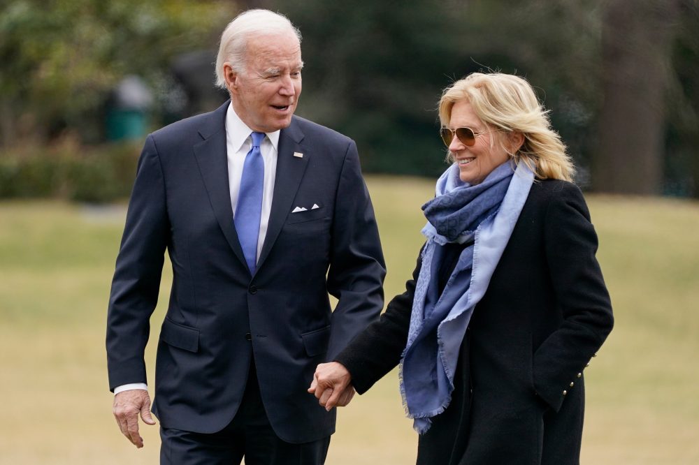
Former President Joe Biden and First Lady Jill Biden have welcomed two new four-legged family members to their Delaware residence, bringing home black Labrador-mix siblings they’ve named Boo and Scout.
A Delaware-based animal welfare organization facilitated the adoption, which was announced Monday along with a heartwarming photograph showing the Bidens posing with their new puppies alongside their cat, Willow.
According to Humane Animal Partners, the organization connected the Bidens with these particular dogs after learning the couple was seeking two black Labrador retrievers. The sibling puppies, previously called Linda and Rocky, had been saved from an overcrowded Tennessee shelter facility.
During their White House years, the Bidens were recognized for having German shepherds, though two of those dogs were relocated following biting episodes. Major was moved to live with family friends in 2021 after incidents involving Secret Service agents and White House personnel, while Commander was removed two years afterward.
Joe Biden had received Commander as a present from his brother James in December 2021.
In a recent conversation with The Associated Press, Jill Biden revealed that she and the former president chose not to bring Major and Commander back after departing the White House.
The couple also lost their German shepherd Champ in 2021 when he passed away at 13 years old.
Staff members at the animal welfare organization specifically selected Boo and Scout for the Biden family. “Our team intentionally brought them to HAP because we believed they would be a great fit for the Bidens and their home,” stated Patrick Carroll, CEO of Humane Animal Partners.
The organization noted that the Bidens initially brought the puppies home on a trial arrangement before finalizing the adoption process.
Motorists traveling on Route 1 should expect delays as construction work has forced the closure of the northbound left lane between Paynter Lane and Broadkill Road.
According to the Delaware Department of Transportation, the lane restriction will remain in place until 6:00 AM. Drivers are advised to plan alternate routes or allow extra travel time when heading through this area.
The construction activity is affecting traffic flow in the northbound direction only, with the closure specifically impacting the left travel lane of the highway.
Australia’s internet safety watchdog announced Tuesday it is examining five major social media companies for possible violations of the nation’s pioneering law prohibiting users under age 16 from accessing their platforms.
The investigation represents the government’s first public review of how well companies are following the groundbreaking legislation, which is drawing attention from lawmakers worldwide. Poor enforcement could weaken support for similar age restrictions being considered by other governments.
Julie Inman Grant, who leads the eSafety Commission, identified Meta’s Facebook and Instagram, along with Snapchat, TikTok and Google’s YouTube as the platforms under scrutiny. Her agency is collecting evidence for potential penalties against these companies.
“While social media platforms have taken some initial action, I am concerned through our compliance monitoring that some may not be doing enough to comply with Australian law,” Inman Grant stated.
“We are now moving into an enforcement stance,” she continued.
The Australian legislation allows regulators to impose penalties reaching A$49.5 million (approximately $34 million) on companies that fail to comply. Officials noted Tuesday that violating platforms also risk significant damage to their public reputation.
The safety commission discovered significant shortcomings in how platforms are implementing the youth ban. These include asking children who previously indicated they were under 16 to verify their age again, permitting multiple attempts at age verification until users achieve a result showing they’re over 16, inadequate systems for reporting underage accounts, and weak protections against new sign-ups by minors.
Each platform has received notification about specific problems and expectations for addressing these issues, according to the regulator.
TikTok refused to provide comment on the investigation, while representatives from Meta, Snap and Google did not respond immediately to requests for statements.
Several high-scoring college basketball players have announced their intentions to enter the transfer portal when it opens on April 7, according to multiple reports.
Georgia’s leading scorer Jeremiah Wilkinson, who averaged 17.4 points per game this season, will enter the portal according to his representatives who spoke with On3 on Monday.
The 6-foot-1 guard completed his sophomore year at Georgia after transferring from Cal, where he earned ACC Sixth Man of the Year honors for 2024-25 during his freshman campaign. Across 63 career games, Wilkinson has averaged 16.3 points, 2.0 rebounds and 1.6 assists per game.
During his time with the Bulldogs, Wilkinson converted 35.7% of his three-point attempts while contributing 2.0 rebounds and 1.7 assists across 31 games with 21 starts. He made 79 three-pointers and recorded 49 steals this season, concluding with a 30-point performance in Georgia’s first-round NCAA Tournament defeat to Saint Louis, where he went 7-for-15 from beyond the arc.
The transfer portal window runs from April 7-21, though many players are announcing their decisions early.
Butler guard Finley Bizjack, who ranked third in Big East scoring with 17.1 points per game, will also enter the portal while exploring NBA draft possibilities, according to On3.
Bizjack earned All-Big East third-team recognition after shooting 42.6% from the field and 34.9% from three-point range while adding 2.5 assists and 2.2 rebounds per game. Over three seasons with Butler, he compiled averages of 10.4 points and 2.1 rebounds in 98 games with 61 starts, shooting 36.1% from three-point territory.
Butler recently underwent a coaching transition, with former Butler standout Ronald Nored taking over for retiring coach Thad Matta.
Louisville freshman Sananda Fru, a German big man, plans to enter the portal following his first collegiate season, multiple outlets reported.
The 6-11 forward shot an exceptional 75.3% from the field, including 76.5% on two-point attempts, for the Cardinals. Fru contributed 9.0 points, 6.1 rebounds and 1.4 blocks per game across 35 appearances with 29 starts, playing 22 minutes per contest.
Colorado forwards Sebastian Rancik and Bangot Dak, the team’s third and fourth-leading scorers respectively, have also decided to transfer, according to reports.
Rancik produced 12.3 points and 5.6 rebounds per game in 29 games with 26 starts, while the 7-foot Dak averaged 11.5 points, 6.5 rebounds and 1.6 blocks across 32 games with 30 starts.
Their departures follow Colorado’s top scorer, freshman guard Isaiah Johnson who averaged 16.9 points per game and was reported Friday to be portal-bound. The exodus leaves Colorado potentially short-handed for this week’s College Basketball Crown.
Ohio State forward Devin Royal announced Sunday he will explore the transfer portal after three years with the program.
Royal started for the Buckeyes for the second consecutive season, averaging 13.7 points per game, matching his previous season’s output. Through 96 career games with 59 starts, he has averaged 10.6 points and 4.9 rebounds per game. This past season, Royal expanded his range, making 31 of 98 three-point attempts across 32 games.
Jackson State guard Daeshun Ruffin, Division I’s fifth-leading scorer and SWAC Player of the Year, confirmed to The Field of 68 his portal intentions.
Ruffin averaged 23.3 points, 5.3 assists, 2.8 rebounds and 1.6 steals per game across 28 starts in his second season with the Tigers. He previously appeared in 25 games over two seasons at Ole Miss from 2021-23. Throughout his career, the scoring guard has averaged 17.0 points, 4.3 assists, 2.5 rebounds and 1.6 steals, though he requires an NCAA waiver for next season’s eligibility.
Montana’s Money Williams, a two-time All-Big Sky selection, has decided to transfer from the program.
Williams led the Big Sky and ranked 22nd nationally with 20.6 points per game this season, also contributing 4.7 assists and 4.3 rebounds per contest. Over 81 games with 60 starts for the Grizzlies, he averaged 16.3 points, 3.9 rebounds and 3.8 assists per game.
Saint Mary’s center Andrew McKeever, who topped the West Coast Conference in rebounding, will enter the portal with two years of eligibility remaining.
The 7-3, 285-pound McKeever averaged 8.2 points and 9.2 rebounds per game in 33 games with 10 starts for the Gaels. KenPom.com ranked him second nationally in offensive rebounding rate. His decision follows longtime Saint Mary’s coach Randy Bennett’s departure to Arizona State.
Missouri’s Anthony Robinson II will enter the portal after spending three years with the program.
Robinson started 31 games in 2024-25 before losing his starting position midway through this season, finishing with 33 games and 19 starts. He averaged 8.9 points, 3.1 rebounds, 3.0 assists and 1.6 steals this year, bringing his career averages to 7.4 points, 2.7 rebounds, 2.5 assists and 1.7 steals through 96 games with 50 starts for the Tigers.
A financial representative working for Defense Secretary Pete Hegseth reportedly sought to make a substantial investment in defense industry stocks during the weeks before a joint U.S.-Israeli military operation targeting Iran, according to a Monday report from the Financial Times.
The broker, working through Morgan Stanley, reached out to investment giant BlackRock during February regarding a multimillion-dollar purchase of the company’s Defense Industrials Active ETF, the report stated. This contact occurred shortly before Washington launched its military response against Tehran, according to three sources with knowledge of the situation cited by the Financial Times.
Drivers traveling north on Coastal Highway should expect delays this afternoon as construction crews have blocked off the left lane between Paynter Drive and Broadkill Road.
The Delaware Department of Transportation reports the lane restriction on Route 1 northbound will stay in effect until 3 PM today. Motorists are advised to use caution in the work zone and allow extra travel time.
The affected stretch runs from Paynter Drive to the intersection with Route 16, also known as Broadkill Road. Traffic is being funneled into the remaining right lane during the construction period.
Israel’s legislative body voted Monday to enact capital punishment for individuals who commit deadly terrorist attacks, with lawmakers approving the controversial measure by a margin of 62 to 48 votes despite significant political opposition and pressure from international allies.
The bill, which completed its second and third readings on March 30, 2026, establishes that “a terrorist who intentionally caused the death of a person as part of a terrorist act – his sentence is death.”
Prime Minister Benjamin Netanyahu cast his vote supporting the measure, even though the bill was expected to secure enough votes without his backing. The opposition Israel Beiteinu party supported the legislation, while United Torah Judaism, a member of the governing coalition, opposed it. Following the vote, National Security Minister Itamar Ben Gvir, who helped initiate the proposal, declared: “We are making history.”
Under the new statute, capital punishment becomes required in specific circumstances and eliminates the need for judges to reach a unanimous verdict. The law specifies that the Israel Prison Service will conduct executions by hanging within 90 days, with no option for presidential clemency.
Government sources indicated the statute will face review by the High Court of Justice.
Legal scholars have identified several constitutional concerns, including the automatic nature of the death sentence and clauses preventing pardons, along with disparities in how the law applies to Israeli citizens versus cases in the West Bank.
Opposition leader Yair Lapid criticized the legislation, stating: “This law will not lead to a single execution. Not in Gaza, not in Judea and Samaria, not of terrorists, and not of anyone else. It is deliberately written without filters and without balances, for one purpose only: to ensure that it will be struck down.”
According to N12 news, high-ranking European officials conducted emergency discussions with Israeli representatives in an attempt to block the legislation, threatening potential sanctions and the suspension of trade deals, technological partnerships, scientific collaboration, and diplomatic relations.
Motorists traveling on South Rehoboth Boulevard are dealing with lane restrictions today as DelDOT has closed the right shoulder in the northbound direction.
The shoulder closure affects the stretch of roadway between Longview Drive and Cedar Beach Road and is expected to remain in place until 5:00 PM this evening.
Drivers are advised to use caution in the area and allow extra travel time due to the reduced lane availability.
Yemen’s Houthi forces fired their first ballistic missiles directly at Tel Aviv since the October ceasefire ended, launching attacks in the early morning hours of Saturday, March 28, 2026. A follow-up operation occurred Sunday, March 29, with the group using drones and cruise missiles to target what they called strategic locations in Eilat.
The attacks occurred one month into the US-Israel conflict with Iran and have heightened concerns about potential closure of international shipping through the Bab el-Mandeb Strait. The Houthis announced their participation in the conflict as part of the “axis of resistance,” but Yemen’s unstable internal conditions could face serious repercussions. Peace negotiations with Saudi Arabia that were nearly finalized are now in jeopardy, potentially triggering new international responses that could further devastate the nation’s crumbling infrastructure.
Mohammed Salem, using a pseudonym and working with Houthi war media, explained that these operations were carefully planned strategic moves rather than impulsive actions. “The military wing has studied the situation closely since the first day of the regional war,” he stated, explaining that joining the conflict represents “a response to the will of the Yemeni people and a national and religious duty to support the resistance in Palestine, Lebanon, Iraq, and Iran.”
Salem emphasized that the Houthis aren’t using these attacks as negotiating leverage to secure better terms, describing them as part of their ongoing campaign against what he called the Zionist and American enemy. He noted that Yemen now controls significant military resources, positioning it among major regional powers, and cautioned that “the coming days will reveal many surprises that will astonish the world, as we are still in an escalating phase until the aggression stops on all fronts.”
The cross-border attacks have created a sharp division within Yemeni society, going beyond military and political considerations. This split demonstrates vastly different views of the current crisis—with supporters believing the escalation restores national pride, while critics worry it will destroy the nation’s final opportunities for survival.
Mohammed, a young Sanaa resident who backs the Houthis’ actions, spoke enthusiastically to The Media Line about the Tel Aviv strikes representing a pivotal moment that restored Yemen’s international position.
He maintained that Yemenis—previously relegated to being seen as a “forgotten civil war”—have proven they cannot be overlooked in regional politics. Speaking boldly, he dismissed concerns about potential Israeli or American retaliation, asking what more a population devastated by years of blockade and poverty could possibly lose. He argued that “dying with dignity” through direct confrontation is better than “a slow death” while depending on limited humanitarian assistance, calling the expected sacrifices “an inevitable price for freedom and dignity.”
However, strong opposition voices are emerging elsewhere. Badri Saleh, who lives in al-Jawf governorate, characterized the military involvement as dangerous gambling that leads the nation toward “collective suicide” to serve foreign interests.
He expressed regret over the missed opportunity for a significant peace agreement with Saudi Arabia—which was nearly completed—that could have reduced domestic hardship. Instead, he argued, the missile attacks have undermined political progress “to satisfy Tehran.”
Saleh’s worries go beyond political breakdown to include fears of extensive infrastructure destruction, warning that a strong international response could hit ports and airports, driving the country into “economic paralysis” with no clear way out.
Abdulsalam Mohammed, who leads Abaad Studies & Research Center, described what he called substantial military preparation by the Houthis. He reported that the Houthis currently control 200 missile launch locations strategically placed throughout Saadah, Hodeidah, al-Jawf, and Taiz, plus 300 drones, including large suicide drone models appearing in combat for the first time.
He also highlighted a major change in naval operations, mentioning an “underwater base” with unmanned submarines, along with launch sites for explosive boats in as-Salif and Hodeidah. These capabilities are backed by secret manufacturing and development facilities built inside mountain tunnels in Sa’dah.
Mohammed additionally claimed that approximately 2,000 foreign specialists—primarily former Syrian army officers and Hezbollah and Iraqi armed group members—are managing technical operations. He stated that strategic planning and advanced operational coordination remain connected to Iran’s Revolutionary Guard command center, while the local group focuses on mobilization and field implementation.
Military affairs analyst and journalist Adnan al-Jabarni rejected the notion that the armed intervention is simply reactive. In analysis posted on X, he argued the Houthis intentionally started their direct involvement by attacking Tel Aviv to accomplish strategic goals—primarily to trigger a direct Israeli response. This approach, he contended, establishes the group as a major player in the conflict while reducing perceptions of complete tactical reliance on Iran.
Al-Jabarni noted that the Houthis are following a “gradual entry” strategy based on “axis of resistance” requirements.
If Iran’s current goals involve wearing down Israeli defenses and causing direct harm, the emphasis will continue on Israeli territory. However, if objectives change toward applying political and economic pressure on the US administration—especially to complicate President Donald Trump’s strategic calculations—then efforts might shift toward limiting navigation through the Bab el-Mandeb Strait and potentially attacking regional military installations under sovereignty claims to expand the pressure campaign.
He concluded that if the Axis fully commits to this confrontation, especially during perceived weakness or distraction in Tehran, the region might face an extended conflict with a definitive result—either favorable or unfavorable to them.
As missiles illuminate regional skies, Yemen finds itself once more at the heart of a historic crisis that has continued for decades. From internal mountain conflicts to open maritime confrontations, the nation has transformed into a global battleground for rival powers. While the international community monitors the straits and shipping lanes, average Yemenis remain trapped between hopes of reconstructing their homeland and the reality of international conflicts.
Federal authorities have officially labeled a violent incident at Michigan’s largest Jewish house of worship as terrorism motivated by the Lebanese militant group Hezbollah.
The March 12 assault on Temple of Israel involved 41-year-old Ayman Ghazali, who drove his vehicle into the synagogue building before firing weapons at security personnel and detonating fireworks in an explosive blast, according to Jennifer Runyan, who leads the FBI’s Detroit regional office. Ghazali, originally from Lebanon who obtained American citizenship in 2016, died by suicide during the incident.
Fortunately, no other fatalities occurred despite young children being present for preschool activities at the time of the violence.
According to Runyan’s findings, Ghazali had been consuming materials promoting Hezbollah’s ideology before carrying out his plan, though federal agents cannot confirm whether he held formal membership in the organization. Investigators found no evidence suggesting he worked with accomplices.
Hezbollah emerged in 1982 with backing from Iran’s Revolutionary Guard forces. American officials have classified both groups as terrorist organizations.
Jerome Borgen, who serves as U.S. Attorney for Michigan’s Eastern District, stated: “Had this man lived, I am convinced that my office would prove beyond a reasonable doubt that he committed the federal crime of providing material support to Hezbollah.”
Investigation records show that one day prior to the synagogue assault, Ghazali began posting images on social platforms featuring Iran’s Supreme Leader Ayatollah Ali Khamenei, who died in recent U.S.-Israeli military operations. On the morning of the attack, while positioned in the temple’s parking area, Ghazali sent his sister a message revealing his intention “to commit a mass terrorist attack.”
Federal crime statistics indicate a troubling rise in anti-Jewish incidents nationwide, with attacks targeting Jewish Americans representing almost two-thirds of more than 5,300 religiously-motivated hate crimes documented since February 2024.
Consumer products giant Unilever is reportedly close to finalizing negotiations to merge its food operations with American spice manufacturer McCormick, according to a Wall Street Journal report published Monday.
Sources with knowledge of the discussions told the publication that the potential transaction would involve approximately $16 billion in cash payments. The talks are described as being in their final stages.
The proposed deal would bring together Unilever’s food division with McCormick, the well-known U.S.-based spice and seasoning company. Both companies have yet to publicly confirm the negotiations.
Motorists traveling southbound on US Route 13 in New Castle will need to navigate around construction activity that has shut down the right lane between Delaware Avenue and Chipmans Lane.
The Delaware Department of Transportation reports the lane restriction will stay in place through 5 a.m. as crews continue their work on the busy corridor.
Drivers should expect potential delays and are advised to allow extra travel time when using this section of Route 13 during the construction period.
CAPE CANAVERAL, Fla. — The space agency kicked off launch preparations Monday for the first human journey to the moon since the Apollo program concluded more than five decades ago.
A towering 32-story Space Launch System rocket stands ready to carry four astronauts into space Wednesday evening. Following one day orbiting Earth, their Orion spacecraft will transport the crew on a lunar flyby mission. The journey involves no lunar landing — simply a swift loop around the moon before returning home. The mission will conclude nearly 10 days later when the capsule touches down in Pacific Ocean waters.
Launch director Charlie Blackwell-Thompson expressed confidence about the upcoming mission. “Our team has worked extremely hard to get us to this moment,” she stated. “Certainly all indications are right now we are in excellent, excellent shape.”
Mission supervisors reported the rocket is performing well after completing recent maintenance work. Weather forecasters predicted favorable conditions for the launch window.
The Artemis II mission faced multiple delays from its original February timeline due to hydrogen fuel system problems. After resolving those leaks, engineers discovered a blocked helium pressurization line, requiring another trip back to the assembly building last month. The rocket returned to its launch position a week and a half ago, while the international crew of American and Canadian astronauts arrived at the facility Friday.
This mission marks a departure from the Apollo program, which transported only male astronauts to lunar orbit between 1968 and 1972. The Artemis II crew breaks new ground by including a female astronaut, a person of color, and an international crew member.
Mission pilot Victor Glover shared his hopes for inspiring the next generation during weekend remarks. “Girl power and that’s awesome, and that young brown boys and girls can look at me and go ‘Hey, he looks like me and he’s doing what???’” he said.
Glover, who is African American, also expressed his vision for the future of space exploration. He anticipates a time when “one day we don’t have to talk about these firsts” and cosmic exploration becomes part of universal “human history.”
The space agency has established a launch window spanning the first six days of April for Artemis II, after which operations will pause until month’s end.
Professional entertainers in full makeup and bright red noses took their concerns to the streets of Bolivia’s capital city Monday, rallying against a new educational policy that threatens to eliminate their primary source of income.
The colorfully dressed performers assembled outside La Paz’s Ministry of Education building to voice opposition to regulations implemented in February. The new rules require educational institutions to dedicate 200 full days annually to academic instruction, essentially prohibiting the special celebrations and events where these entertainers typically find work.
Wilder Ramírez, who represents the local performers’ union and performs under the stage name Zapallito, expressed concerns about the financial impact. “This decree will economically affect all of us who work with children,” Ramírez told reporters. He emphasized that “children need to laugh” while fellow performers questioned whether Bolivia’s Education Minister had experienced a proper childhood.
These professional entertainers regularly provide services at educational institutions throughout Bolivia, performing during school celebrations and special occasions that break up the regular academic routine. An important upcoming celebration is the nation’s Children’s Day observance on April 12.
The policy comes from recently elected President Rodrigo Paz’s administration, which states that festive activities will no longer receive approval during regular academic hours, though schools may choose to organize such events on weekends. Administrative officials indicated they would consider the entertainers’ concerns when developing policies for the 2027 academic year.
However, these future promises offered little comfort to Monday’s demonstrators.
“This decree will diminish our income, and with the economic crisis the country is going through, our future looks increasingly gloomy,” stated Elías Gutiérrez, representing the Confederation of Artisanal Workers of Bolivia.
The South American nation faces severe economic challenges as natural gas revenues continue declining due to reduced production levels, while U.S. currency shortages drive up import costs for the landlocked country.
The demonstration included additional workers whose livelihoods depend on school events, including seamstresses who create costumes for children’s performances and photographers who document educational celebrations.
The coalition of affected workers paraded through downtown La Paz, using whistles and small pyrotechnics to draw attention to their cause.
One demonstrator displayed a sign accusing government officials of “taking away smiles, and taking work away.”
Plans to honor conservative activist Charlie Kirk with a highway designation in Arizona have been blocked by the state’s governor, sparking a political dispute over the decision.
Governor Katie Hobbs, a Democrat, rejected the Republican-backed proposal on Friday that would have named Loop 202, which runs through the Phoenix metropolitan area, after Kirk. The conservative figure, who founded Turning Point USA and was known for campus speaking events, was killed during an appearance at Utah Valley University last year.
The controversy centers on competing claims about political motivations behind the naming process.
Hobbs defended her decision in a written statement to legislators, arguing that Republicans overstepped by bypassing the established process for highway designations.
“I will continue working toward solutions that bring people together, but this bill falls short of that standard by inserting politics into a function of government that should remain nonpartisan,” Hobbs stated.
Republican Senate President Warren Petersen, who authored the legislation, accused the governor of breaking established customs for recognizing influential figures.
“The veto tells people that recognition now depends on political alignment, not contribution,” Petersen responded. “That’s not how Arizona has ever approached these decisions, and it’s a disappointing shift for our state.”
The Arizona dispute reflects a broader national movement to commemorate Kirk. Data from bill-tracking service Plural shows lawmakers across more than 20 states have proposed over 60 measures related to Kirk’s legacy, according to Associated Press research.
These proposals range from memorial designations and commemorative days to legislation promoting campus free speech protections and educational initiatives highlighting Judeo-Christian influences in American history.
Both Arizona and Florida were early adopters of Kirk-related legislation. Florida Governor Ron DeSantis has not yet signed his state’s version, which would create “Charlie Kirk Memorial Avenue” in Miami-Dade County alongside “President Donald J. Trump Boulevard” in Broward County.
WASHINGTON — Middle Eastern partners of the United States are privately pressing President Donald Trump to maintain military operations against Iran, contending that Tehran remains insufficiently weakened after weeks of U.S.-led airstrikes, sources from American, Gulf, and Israeli governments report.
Following initial behind-the-scenes complaints that they received insufficient warning about the U.S.-Israeli offensive and concerns about regional devastation, several allied nations now view this moment as a unique chance to permanently undermine Iran’s religious government.
Representatives from Saudi Arabia, the United Arab Emirates, Kuwait, and Bahrain have privately expressed their desire for military actions to continue until Iran’s leadership undergoes major changes or dramatically alters its conduct, according to officials speaking anonymously due to lack of authorization for public statements.
This regional pressure emerges as Trump wavers between declaring Iran’s weakened leadership ready for negotiations and threatening escalation if agreements aren’t reached quickly.
Meanwhile, Trump faces challenges building domestic support for a conflict that has claimed over 3,000 lives throughout the Middle East and disrupted global economic stability. However, the president appears increasingly confident about backing from key regional partners who initially showed reluctance about renewed military action.
“Saudi Arabia’s fighting back hard. Qatar is fighting back. UAE is fighting back. Kuwait’s fighting back. Bahrain’s fighting back,” Trump stated to reporters aboard Air Force One Sunday evening during his return flight to Washington from Florida. “They’re all fighting back.”
These Gulf nations provide hosting facilities for American forces and military bases used for launching Iranian strikes, though they haven’t participated directly in offensive operations.
Although regional leadership generally supports current U.S. actions, one Gulf diplomatic source noted internal disagreements, with Saudi Arabia and the UAE spearheading calls for intensified military pressure against Tehran.
The UAE has positioned itself as potentially the most aggressive among Gulf states, strongly advocating for Trump to authorize ground invasion operations, the diplomat revealed. Kuwait and Bahrain also support this approach. The UAE, having endured over 2,300 missile and drone strikes from Iran, grows increasingly frustrated as ongoing warfare threatens its reputation as the region’s secure, pristine commercial and tourism center.
Conversely, Oman and Qatar, traditionally serving as mediators between economically isolated Iran and Western nations, prefer diplomatic resolution.
The diplomat indicated Saudi Arabia has argued to American officials that concluding warfare prematurely won’t achieve a “good deal” ensuring security for Iran’s Arab neighbors.
Saudi demands for any eventual settlement include neutralizing Iran’s nuclear capabilities, eliminating ballistic missile systems, ending Tehran’s proxy group support, and preventing future Islamic Republic shutdowns of the Strait of Hormuz as occurred during this conflict. Approximately 20% of global oil previously flowed through this waterway.
Accomplishing these objectives would require dramatic policy reversals by the theocratic government controlling the country since 1979’s Islamic Revolution or complete regime change.
Senior Emirati officials have adopted increasingly direct language regarding Iran.
“An Iranian regime that launches ballistic missiles at homes, weaponizes global trade and supports proxies is no longer an acceptable feature of the regional landscape,” wrote Noura Al Kaabi, UAE Foreign Ministry minister of state, in Monday’s column for state-affiliated English publication The National. She continued: “We want a guarantee that this will never happen again.”
The White House refused comment regarding Gulf ally consultations. However, Secretary of State Marco Rubio emphasized Monday that America and Gulf Arab partners share unified views about Iran.
“They are religious zealots who can never be allowed to possess a nuclear weapon because they have an apocalyptic vision of the future,” Rubio said about Iran during his ABC “Good Morning America” appearance. “And all of their neighbors know that, by the way, which is why all of their neighbors have been supportive of the efforts we’re conducting.”
Crown Prince Mohammed bin Salman, the kingdom’s effective ruler, has informed White House officials that further reducing Iran’s military capabilities and clerical leadership benefits long-term Gulf regional interests and beyond, according to someone briefed on these discussions.
Nevertheless, Saudis remain concerned that prolonged conflict provides Iran additional opportunities for striking the kingdom’s energy infrastructure, which forms the foundation of its oil-dependent economy.
A Saudi government representative emphasized the kingdom ultimately seeks political crisis resolution, but immediate priorities focus on protecting citizens and essential infrastructure.
Trump recently highlighted most Gulf countries’ unified support for his administration’s war prosecution, praising their crisis solidarity while criticizing NATO allies for refusing to join American efforts.
Friday brought Trump’s praise for Bahrain, Kuwait, Qatar, Saudi Arabia, and the United Arab Emirates, commending their “bravery” throughout the conflict.
Speaking at a Miami event sponsored by Saudi sovereign wealth funds, the president offered particular acclaim for the Saudi crown prince, describing him as a “warrior” and “fantastic man.”
Trump also acknowledged Gulf countries’ initial hesitation about his and Israeli Prime Minister Benjamin Netanyahu’s war decision, but noted their subsequent rallying.
“They weren’t thinking this was going to happen, nobody was,” Trump said, referencing Iran’s thousands of retaliatory strikes across the Gulf region. “And they turned against them and really became very powerfully aligned. And they were with us, but they weren’t with us very obliquely. They were with us.”
Trump has not yet requested Gulf nations’ participation in offensive operations.
One consideration may involve administrative calculations that additional militaries beyond Israel would create unnecessary complications in crowded airspace.
Three American fighter aircraft were accidentally shot down by friendly Kuwaiti forces during initial conflict days amid Iranian aerial assault. All six crew members successfully ejected from the F-15E Strike Eagles.
Additionally, six American service members died March 12 when their KC-135 refueling plane crashed in western Iraq.
Another complication involves only UAE and Bahrain maintaining formal diplomatic relationships with Israel among Gulf states, adding complexity to their strategic considerations, notes Yasmine Farouk, International Crisis Group’s Gulf and Arabian Peninsula project director.
However, Iran has threatened attacks on neighbors’ critical infrastructure, including desalination facilities providing regional drinking water, should Trump execute his threat against Iranian power plants if the Strait of Hormuz isn’t reopened by April 6.
“The absence of a clear objective, the absence of the trust that the United States is really going to go until the end and finish the jobs … it’s making some of them reluctant,” Farouk explained. “But if there is a consequential or mass casualty (event) in one of those countries, then it would be justified for them to become a belligerent.”
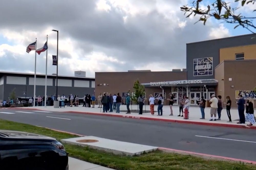
Authorities in Texas are investigating after a 15-year-old student wounded a teacher and then died by suicide Monday morning at a high school near San Antonio.
The incident occurred at Hill Country College Preparatory High School in Bulverde, a growing community outside San Antonio. Officials report no additional injuries beyond the wounded educator.
The injured teacher was transported to a local hospital, though Comal County Sheriff Mark Reynolds said hours later that he remained unaware of her medical status.
“What happened today is something no community ever wants to face, but we prepare for something that we hope never occurs,” Reynolds stated.
According to Reynolds, the teenager fired at the teacher before turning the weapon on himself. Investigators are now examining the connection between the student and educator while also determining how the firearm was acquired.
The campus, which serves approximately 250 students, went into lockdown procedures around 8:30 a.m., school officials confirmed. A student witness told San Antonio’s KSAT television that loud noises erupted from a second-floor classroom, followed by screaming.
Another student described hearing five gunshots and shouting before a debate instructor directed students into a secure classroom.
School buses transported students to a neighboring middle school facility, where parents formed lengthy queues as they awaited reunification with their children. Some families were seen praying during the wait. Reynolds noted that relatives of the shooter also joined the reunification process.
“We’re trying to collect as much information as we can from witnesses,” Reynolds explained.
Parent Jesse Lopez expressed concerns to KSAT about his daughter’s eventual return to classes.
“For one, she has autism, and she’ll be afraid to go back, she’ll be real afraid to go back,” Lopez shared.
Principal Julie Wiley announced that Tuesday’s classes would be suspended, though counseling services would remain available for students and families. Her statement did not include updates on the teacher’s medical condition.
“Our hearts are with everyone impacted, especially that teacher, their family, and our school community,” Wiley expressed. “We know this has been a difficult day.”
The institution operates under the Comal Independent School District and emphasizes college preparatory academics. The school’s curriculum revolves around science, technology, engineering, arts and mathematics (STEAM), offering specialized courses in cybersecurity and engineering.
Hill Country College Preparatory opened its doors in August 2020 with an initial freshman class and has expanded to include all high school grade levels.
Anaheim Ducks defenseman Radko Gudas announced he will take the ice Monday against the Toronto Maple Leafs, despite dealing with a lower-body injury that kept him out of Saturday’s game.
The matchup carries significant tension after Gudas delivered a knee-on-knee blow that ended Toronto star Auston Matthews’ season on March 12. The NHL handed Gudas a five-game suspension for the illegal contact, though Toronto players didn’t immediately retaliate during that March contest.
“It’s on me for not responding earlier to Gudas,” said Maple Leafs defenseman Morgan Rielly, who was on the ice when the incident occurred. “Obviously, it’s a dirty hit. I didn’t understand how bad he got him in the moment, but I take full responsibility for not being the first one in there or not being in there quicker to respond.”
The 35-year-old Gudas sustained his current injury during Thursday’s matchup with Calgary and was spotted wearing a walking boot. He missed Saturday’s contest against Edmonton but refuses to use the ailment as an excuse to avoid what could be a heated encounter with the Leafs.
“I think it’s gonna be an intense game. Yeah, one of the reasons why I wanted to play, you know, address things,” Gudas explained to media during Monday’s practice session. “You never want to watch your team play without you. I’m doing everything to play these games.”
“… Stand behind my own mistakes. I want to address it myself. So, that’s one of the reasons one hundred percent. It’s one of those games where I – where I have to play,” he added.
Matthews suffered a Grade 3 MCL tear and quad contusion from Gudas’ hit, requiring season-ending surgery on March 19. The injury effectively ended Toronto’s playoff hopes.
Currently in his 14th NHL campaign, Gudas has recorded two goals and 11 assists across 54 games this season, accumulating 45 penalty minutes. Throughout his career spanning stints with Tampa Bay (2012-15), Philadelphia (2015-19), Washington (2019-20), Florida (2020-23), and Anaheim, he has compiled 42 goals, 169 assists, and 1,102 penalty minutes over 883 games.
The Ducks enter Monday’s game with a 41-28-4 record and 86 points, maintaining a three-point advantage over Edmonton for the Pacific Division lead with nine contests remaining in the regular season.
The maker of Dove soap and other popular household products has stopped recruiting new employees worldwide for a minimum of three months, blaming economic pressures from the expanding Middle East conflict, according to an internal company document obtained by Reuters.
Unilever announced the immediate hiring halt across all positions in a memo distributed to workers last week, pointing to substantial obstacles created by the month-long Iran conflict.
Companies across various industries including aviation and retail are working to protect themselves from the Iran war’s impact, which has disrupted international commerce and created unprecedented interruptions to oil and gas distribution worldwide. Rising energy prices are already affecting other sectors, causing slower manufacturing in chemical and plastic industries.
“Macro economic and geopolitical realities, especially in the Middle East conflict… bring some significant challenges for the coming few months,” wrote Fabian Garcia, who leads Unilever’s personal care division, in the staff memo.
“With this in mind, the Unilever Leadership Executive team has agreed a global recruitment freeze at all levels. This will be effective immediately and last for a minimum of three months.”
The British consumer products company controls many internationally recognized brands. Although most manufacturing occurs in the same regions where products are sold, the company purchases chemicals, food ingredients, packaging materials and other supplies that require significant energy to produce.
In an official response, Unilever confirmed that because of the “uncertain external environment, we have decided to put in place a temporary pause on our recruitment,” stating the company will “always adjust our plans as necessary.”
The recruitment suspension adds to existing expense reduction efforts Unilever began in 2024, designed to eliminate approximately 800 million euros ($916.72 million) in spending over three years. Those earlier changes were projected to impact roughly 7,500 positions worldwide, primarily office workers.
The company’s workforce has shrunk to 96,000 employees from about 149,000 in 2020.
Unilever has faced difficulties increasing sales volume throughout its operations following the COVID-19 pandemic. The company announced March 20 that it’s discussing selling its food division to competitor McCormick & Company.
The potential deal, which would represent a significant restructuring under CEO Fernando Fernandez, would likely allow British shareholders to maintain controlling interest in the combined organization, according to recent Reuters reporting.
WASHINGTON – Military officials announced Monday they are launching an investigation into why Army helicopters conducted operations near the Nashville home of musician Kid Rock, a prominent supporter of President Donald Trump, as well as near ongoing anti-administration demonstrations.
The country music star shared footage on social media over the weekend displaying two Apache helicopters flying past his Tennessee residence. In the clip, Rock can be observed giving a military salute to one of the aircraft while positioned near his backyard pool.
The same military aircraft were reportedly observed flying in close proximity to protesters in Nashville who were demonstrating against Trump’s immigration enforcement policies, potential military action in Iran, and other administration initiatives.
Major Montrell Russell, speaking for the U.S. Army, explained the situation: “Army aviators must adhere to strict safety standards, professionalism, and established flight regulations. An administrative review is underway to assess the mission and verify compliance with regulations and airspace requirements.”
Russell continued: “Appropriate action will be taken if any violations are found. Until the review is complete, there will be no further comment.”
The incident raises questions about military neutrality, as armed forces are expected to remain nonpartisan and serve the Constitution rather than any specific political faction or ideology.
Defense Secretary Pete Hegseth has been actively restructuring military leadership since taking office, removing senior officers while working to advance Trump’s defense priorities and eliminate what he characterizes as discriminatory diversity programs.
Congressional Democrats have expressed concern that the current administration is attempting to leverage military resources for political purposes.
In his social media post featuring the helicopter footage, Rock made critical remarks about California’s Democratic Governor Gavin Newsom.
“God Bless America and all those who have made the ultimate sacrifice to defend her,” Rock wrote alongside the helicopter video.
The weekend demonstrations were part of the nationwide “No Kings” protest movement, with organizers planning more than 3,200 events across all states. Previous iterations of these protests have drawn millions of participants nationwide, with local media reporting thousands participating in the Nashville demonstrations.
General Motors announced Monday it will keep its Detroit electric vehicle manufacturing facility closed until April 13, extending a shutdown that started March 16.
The company stated that “Factory ZERO will temporarily adjust production to align EV production with market demand,” resulting in temporary layoffs for 1,300 employees.
The facility manufactures the Chevrolet Silverado EV and Hummer EV models and has experienced inconsistent production schedules throughout the past year as General Motors grapples with declining consumer interest in electric vehicles. The company already reduced the plant’s output by approximately 50% in January.
General Motors has accumulated $7.6 billion in losses from its electric vehicle initiatives and joins other major automakers scaling back their electric vehicle strategies amid significant policy changes under President Donald Trump’s administration.
The automotive industry is now focusing more heavily on manufacturing gasoline-powered trucks and SUVs, which remain Detroit’s primary revenue generators. General Motors announced Monday its intention to boost heavy-duty truck production at a Michigan facility beginning in June.
The large-format cinema company IMAX Corporation announced Monday that Chief Executive Richard Gelfond will temporarily step away from his leadership role while undergoing treatment for pneumonia.
During Gelfond’s absence, the company’s day-to-day operations will be handled by senior leadership working alongside Chairman Darren Throop, according to the announcement.
“We have a strong, deeply experienced senior executive team who are fully engaged, providing regular updates to the board, and remain focused as always on the continued growth and success of IMAX,” Throop said in a statement.
The company indicated that Gelfond will skip upcoming corporate events, including industry conferences scheduled for the following week, while he focuses on his recovery.
In February, IMAX announced fourth-quarter earnings that exceeded Wall Street expectations, reporting revenue of $125.2 million compared to analyst projections of $120.7 million, based on data from LSEG.
Motorists will need to find alternate routes along a portion of Kent Avenue for an extended period, as DelDOT announces a lengthy road closure lasting until spring 2026.
The affected roadway spans from Oakwood Street to East Jefferson Bridge Road, with the closure scheduled to remain in effect until 6:00 AM on May 1, 2026.
Drivers are advised to plan alternative routes and allow extra travel time when navigating the area during this extended construction period.
Delaware Department of Transportation has closed the right shoulder along a section of northbound South Rehoboth Boulevard for ongoing construction work.
The shoulder closure affects traffic traveling north on South Rehoboth Boulevard between Longview Drive and Cedar Neck Road. Motorists should expect the construction zone to remain active through April 30, 2026, with the shoulder reopening scheduled for 5 p.m. that day.
Drivers using this route are advised to exercise caution when traveling through the work zone and allow extra time for their commute while construction crews complete the project.
Listen to the Evening Delmarva Farm Report Update — March 30, 2026
DELMARVA — Fieldwork wrapped up early across Delmarva on Monday as scattered rain showers were expected overnight into Tuesday morning. Growers who completed fertilizer applications over the weekend are in good shape, but Tuesday was expected to be a split day with morning showers clearing by afternoon. Soil temperatures are holding in the low 50s, keeping early corn planters on hold for at least another week.
Markets
May corn closed at $5.12 per bushel, up 3 cents. July soybeans finished at $11.48, down 2 cents. July wheat ended at $6.81, gaining 4 cents on the session.
Local cash corn on Delmarva is running $4.90 to $5.00 at the elevator. Soybeans are bringing $11.10 to $11.25 depending on location.
Forecast
Scattered showers were expected to taper off overnight with lows around 54 degrees and southwest winds 10 to 15 miles per hour. Tuesday was forecast to improve with morning scattered showers giving way to mostly sunny skies by midday. Highs were expected to reach the low 70s with southwest winds continuing 10 to 15 miles per hour.
Wednesday was forecast to see mostly sunny conditions warming into the mid-70s before rain returns late in the day.
This article is based on the Delmarva Farm Report Update Evening Edition, March 30, 2026. Hosted by Tom Bradley.
Soccer legend Lionel Messi will take the field from the opening whistle when Argentina faces Zambia in a friendly match on Tuesday, according to national team coach Lionel Scaloni.
Speaking to the media on Monday, Scaloni confirmed the star player’s role in the upcoming game. “Yes, I think he’ll start from the beginning tomorrow,” Scaloni stated during his press conference.
This marks a change from Argentina’s previous friendly encounter, where Messi entered the match at halftime during their 2-1 win over Mauritania on Friday.
According to Scaloni, both the Mauritania and Zambia friendlies serve a crucial purpose in finalizing Argentina’s World Cup squad. The coach explained that these games will help determine the final 26-man roster for this summer’s tournament.
“The list of 26 players (for the World Cup), I think we’re above the percentage,” Scaloni explained. “We have to start discarding options now based on performance. There is no other option.”
The defending World Cup champions faced unexpected challenges against Mauritania, a team ranked 115th globally by FIFA and without any World Cup appearances in their history.
Reflecting on that performance, Scaloni noted: “The game the other night could’ve been an alert. It’s things that as a head coach one starts looking at and later, we will decide.”
While Messi’s World Cup participation remains undecided, Scaloni expressed optimism about the global icon’s potential involvement in the tournament.
“The important thing is that he comes and enjoys it,” the coach shared. “That he enjoy being at the World Cup, which in theory would be the last, but I wouldn’t dare to say anything, but that he enjoys it.”
Scaloni emphasized the worldwide appeal of seeing Messi compete: “I think it’s not just Argentines who want to see him, everyone wants to see him. They want to see him train, see him play, and that is what we all wish for.”
As Argentina pursues their fourth World Cup title, they will begin group stage play on June 16 against Algeria in Kansas City as part of Group J. Their tournament schedule continues with Austria on June 22, followed by Jordan on June 27.
Major U.S. stock markets tumbled to seven-month lows on Monday as concerns about economic growth overshadowed inflation worries, with the Iran conflict now stretching into its fifth week and oil prices climbing further past the $100 mark.
The S&P 500 and Nasdaq both reached their lowest points since August, while government bond yields declined as investors grew increasingly worried about the economic impact of the ongoing Middle East crisis.
Market analyst Jamie McGeever noted that the surge in borrowing costs triggered by the Iran war has created particularly challenging conditions for major technology companies, which are heavily investing in artificial intelligence projects and increasingly relying on debt financing.
Asian markets took a beating, with Japan’s market falling 3%, though European markets showed resilience with the STOXX 600 gaining 1% and Britain’s FTSE 100 climbing 1.6%. Wall Street saw mixed results, but the technology-heavy Nasdaq and broader S&P 500 hit their lowest levels since late summer.
Within the S&P 500, only three of eleven sectors declined, but their significant market weight dragged down overall performance. Technology stocks fell 1.5%, industrial companies dropped 1.6%, and energy sector shares declined 0.9%. Notable individual losers included Sysco, which plummeted 15%, and Micron Technology, down 10%.
The dollar strengthened to its highest level since May of last year, while the euro weakened on growth concerns and the yen recovered following intervention warnings from Japanese officials.
In bond markets, U.S. Treasury yields fell 7-9 basis points, with the yield curve between 2-year and 10-year bonds steepening for the second consecutive day to 53 basis points, marking the steepest curve in two weeks.
Commodity markets showed energy strength, with Brent crude rising 1% and West Texas Intermediate jumping 4%. Gold gained 0.5%, and aluminum prices surged 4% on the London Metal Exchange.
As the first quarter nears its end, markets have experienced extreme volatility. Brent crude oil has soared 85%, marking its largest quarterly gain since 1990. Meanwhile, the so-called “Magnificent 7” mega-cap technology stocks have fallen 17%, bringing them close to bear market territory with nearly 20% losses from their October peaks.
The global energy infrastructure has sustained significant damage, with 17% of Qatar’s gas capacity offline and 20% of worldwide oil and gas flows disrupted by the Strait of Hormuz closure. Several Middle Eastern nations, including Saudi Arabia, have been forced to shut down energy production facilities and refineries.
Federal Reserve Chair Jerome Powell stated Monday that U.S. monetary policy is in a “good place,” allowing officials to “wait and see” how energy and supply disruptions affect both employment and inflation objectives. Powell was among the first central bank officials to use this phrase in January of last year.
Despite rising borrowing costs and increased market uncertainty from the Iran conflict, major corporate deals continue. Sysco announced plans to acquire catering supplier Jetro Restaurant Depot in a $29 billion transaction. Unilever is reportedly negotiating to sell its foods division to McCormick & Company for over $30 billion. Earlier this month, a consortium including BlackRock’s Global Infrastructure Partners and Sweden’s EQT AB purchased U.S. power company AES Corp for $33.4 billion.
Looking ahead, investors will monitor Middle East developments and energy market movements. Key economic data releases include Reserve Bank of Australia meeting minutes, Japanese retail sales and unemployment figures, Chinese manufacturing data, German retail sales, eurozone inflation estimates, UK GDP figures, and U.S. consumer confidence and job openings reports. Several Federal Reserve officials are scheduled to speak, including Chicago Fed President Austan Goolsbee and other regional bank presidents.
A young American woman’s battle with homesickness during her college years in France took an unexpected turn thanks to a simple trip to mail letters. Holly Deiaco-Smith was just 19 years old when loneliness struck during her study abroad experience, but a chance meeting at a French postal facility would transform her entire outlook.
What began as a routine visit to send correspondence home became the foundation for a friendship that has lasted for decades. The encounter demonstrates how meaningful connections can emerge from the most ordinary circumstances, even when separated by language barriers and cultural differences.
Deiaco-Smith’s experience highlights how study abroad programs, while challenging for homesick students, can create unexpected opportunities for cross-cultural relationships that endure long after the academic experience ends.
Americans with connections to Israel are facing unprecedented travel disruptions as ongoing conflict forces the cancellation of holiday plans and family celebrations. Flight restrictions and war-related chaos have left travelers scrambling for alternative routes or abandoning trips altogether.
Lily Feinstein, a 20-year-old Dallas student at Reichman University in Herzliya, managed to return home through a grueling journey via Egypt and Greece. “My biggest fear throughout the whole war was getting stuck outside of the country rather than in the country,” said Feinstein, who is studying communications and marketing. “There was never a moment where I felt scared or something was going to happen to me. But rather, if I had to leave, what was going to happen then?”
Despite her concerns, Feinstein departed Israel as Passover approached and her family awaited her arrival for the Seder. After multiple El Al flight cancellations, she chose an unconventional route. “I had a couple of flights booked with El Al. My flights kept getting canceled,” she explained. While flights continued operating from Ben-Gurion Airport, options remained extremely limited, and each new reservation carried risks of being stranded during transit. “I just didn’t want to risk booking another flight and maybe getting stuck again. I just made the decision to go through Egypt.”
Her experience at Cairo’s airport highlighted the current travel crisis affecting Israel-bound passengers. “It was an experience for sure. I definitely wouldn’t recommend it,” Feinstein noted. “It’s not a good feeling when you don’t have the IDF behind you, and you’re alone.”
She described an airport terminal overwhelmed with Jewish travelers attempting to exit the region. “There was nobody else in the airport there. It was literally just Jews. There was not even one Egyptian person in the airport other than the staff and security, but it was chaos. Lines at the door. Their airport’s not equipped to handle what they’re doing.”
Tziril Yurman, who grew up in Israel until age 27 and currently resides on New York City’s Upper East Side working in nursing home admissions and marketing, faced her own disappointment when her March 25 El Al flight to spend Passover with elderly parents in Jerusalem was cancelled at 6 pm.
“Complete and utter devastation,” Yurman described her initial reaction. “I felt like I could not get home. I grew up there. But besides that, it’s home for every Jew, and I still feel stranded.” Having traveled without issues during COVID and following October 7, this situation felt different. “This is the first time where an Israeli, a Jew, who’s holding an Israeli passport, cannot get home.”
Instead of Jerusalem, she will attend a large Passover program in Cancun, Mexico, with her sister, joining over 1,500 participants. Security concerns weigh heavily on her mind, as tourist destinations are “definitely being looked at.” Event organizers have increased escorts and patrols, though she couldn’t confirm whether costs have risen accordingly.
California attorney and mother Melissa Cohen experienced her own devastating disruption. Cohen had spent over a year organizing what she called “the trip of a lifetime” to Israel for her middle daughter Alexa’s bat mitzvah celebration. “We actually hadn’t, I hadn’t been to Israel in over 30 years before last year for our spring break,” she shared. Having previously visited as a Houston teenager with her Jewish community and for her brother’s bar mitzvah, she felt an urgent need to return following October 7.
With Israel “being vilified for everything” in media coverage and Gaza war headlines dominating news, Cohen and her husband decided to show their daughters the country firsthand. “We wanted to take our family for the first time last year, so that we could see for ourselves, so that we could be there, so that we could support Israel, and give our tourism dollars to Israel, and give our children a sense of connection,” she explained. Their spring break trip succeeded: “All of my girls, 16, 12, and 10, fell in love with the country, and felt so connected.”
Upon departing Israel last year, they immediately began planning their bat mitzvah return. “Before we touched down on American soil, we sent a note to all of our friends saying next year in Jerusalem,” Cohen recalled. This trip was designed around joy and normalcy: Tel Aviv beaches, desert excursions, Bedouin tent experiences, and culminating with a bat mitzvah ceremony at the Western Wall. “This was really going to be the trip of a lifetime, in a way,” she said. “Being there with all of these people together, our family and friends traveling together, having one experience together, might not ever happen again.”
Then conflict with Iran escalated. As Israel’s military operations intensified and missiles were exchanged, authorities imposed strict limitations at Ben-Gurion airport: only one departure flight per hour to limited destinations like Athens and New York, with just 50 passengers permitted on any aircraft leaving Tel Aviv. “The vast majority of future bookings, both incoming and outgoing, has ground to a halt,” explained Mark Feldman, CEO of Ziontours Jerusalem, describing a tourism sector “paralyzed by uncertainty.” Tens of thousands of Israelis remain stranded overseas, primarily in North America and the Far East, while organized missions and group tours have virtually disappeared.
Cohen monitored these developments with increasing anxiety. “Starting with the moment we attacked Iran,” she said, “I thought, OK, well, this will be just like the 12‑day war last year. They’re even weaker than they were then, and this should be over soon, and this is good news, because this gives us time … and we’re good to go.” However, each passing day diminished that optimism. She and approximately 40 relatives and friends traveling from Houston, California, New York and Boston experienced what she describes as “whiplash”—alternating between thinking “maybe this is going to happen” and “there’s not a chance.”
Ultimately, airlines made the decision for them. As international carriers suspended Israel routes and remaining seats vanished, Cohen watched her meticulously planned celebration collapse. “They canceled flights, and then it just became very clear, I would say, seven, maybe 10 days ago, it became very clear that this was not going to happen,” she said. Passover and Easter itineraries like hers, typically booked a year in advance, “have crumbled,” Feldman observed, either because airlines ceased operations or “because they have chosen not to be in Israel during a war.”
Despite the chaos, Yurman shares Cohen’s commitment to supporting Israel. “Support the Jewish economy, the Jewish Israeli economy,” she urged. “Support any Israeli thing, anything you can, if it’s something online.” She purchases flowers and gifts for family there, encouraging visitors to buy locally—falafel, ice cream, or larger items—to help stores and tourism recover.
Financial consequences have varied. Cohen’s tour guide confirmed hotel reservations were refundable, providing rare relief. However, her attempt to save on airfare through a third-party ticket agency backfired. “That is not refundable,” she said. Rather than receiving straightforward airline credit, the company imposed “a $400 processing fee, plus a $300 commission fee on each ticket that they’re going to take.” Reflecting on the experience, she acknowledged, “In retrospect, I probably should have just gone directly through United. … I was overly confident that nothing was going to happen.”
Cohen’s miscalculation reflects broader assumptions that Israel’s skies had cleared. “Since the war last year in the summer, everything has been great,” she said. Tourism had surged, hotels required seven-night minimum stays over Passover, and prices climbed sharply as if the crisis had passed. It appeared the country had moved forward and tourists were no longer afraid to visit.
Currently, much of the travel system remains paralyzed. Feldman reports the government has provided no direct assistance, while the “one flight an hour” restriction leaves countless travelers with “no ability” to return home. Arkia, one of Israel’s domestic carriers, now operates solely from JFK to Larnaca, Cyprus, due to landing slot shortages. The US Embassy is transporting American citizens by bus to Amman’s airport in Jordan. “Short of a death certificate or a highlevel El Al frequent flier number, just getting out this week is almost a miracle,” Feldman said.
Feldman noted instances of price gouging amid the chaos: El Al’s $999 NYC economy tickets sell out immediately, with “finding space more than one or two days in advance … not possible,” while Amman’s Royal Jordanian charges $2,900 one-way to JFK, “way more than their normal fare.” Oil price spikes from the war haven’t yet impacted costs, but “will affect future ticket prices, when the system reboots,” he added.
Alternative routes used by Feinstein and others—through Egypt, Jordan, and Cyprus—have become essential lifelines. Foreign journalists enter Israel via land crossings, and Feldman reported “zero reports of any problems (other than a request for tips).”
However, these lifelines are becoming more expensive. At the Taba crossing into Egypt, fees on the Egyptian side have increased again as more stranded travelers use the route to reach connecting flights from Taba or Sharm el-Sheikh. Ynet reported on March 28 that new notices at the crossing announced that starting at March’s end, payments would only be accepted in US dollars, with costs for travelers continuing beyond the first kilometer rising to approximately $120 per person, up from the $60 fee mentioned in recent US Embassy Jerusalem travel advisories. An updated embassy alert on March 27 recommended travelers carry at least $115 cash per person, indicating how quickly this improvised exit route has become both more expensive and complicated.
Even so, the route offers little comfort. Feinstein said she “definitely felt safer in Israel” than in an Egyptian airport crowded with anxious passengers. She is now heading to Florida to meet her family and already worries about her return journey. “I don’t want to have to go through Egypt or Jordan again,” she said. “I’m hoping I don’t have to do that again.”
Yurman plans to return immediately after Passover, regardless of obstacles. “Without a question,” she said.
Cancellations have altered sacred family milestones. Rather than celebrating in Jerusalem at the Kotel, Cohen will now celebrate her daughter’s bat mitzvah at home. “I’ve spent the past week to two weeks planning a new bat mitzvah for April 11, the same day it was supposed to be,” she said. The venue has shifted from Jerusalem’s Old City to the family backyard in the Bay Area.
“Our whole family that was coming to Israel is coming here,” Cohen explained. “Everyone had tickets, they took the time off, they were planning to be away. And we’re going do it here,” she said. “…It’s going to be a very different experience. But I think it will be special, nonetheless.”
Cohen acknowledges that rising antisemitic incidents and anti-Israel sentiments have heightened fears around Jewish communal gatherings. She notes “a lot of concern” about attacks on Jews, but says, “I don’t think it’s going to change how I live my life. That’s just not how I operate daily.” Some of her friends are “very worried, very concerned,” and “don’t like going to synagogues now for bar mitzvahs” or to events with Jewish speakers. “I just can’t live that way,” she said. Yurman shared those concerns but remained determined.
The women say the war itself remains difficult for Americans to understand. As a communications student, Feinstein believes many in the US only see missiles and chaos. “They think that Israel is a scary place, with missiles all the time, and there’s no fun,” she said. Most “don’t even know you can study in English in Israel,” or that young people like her can live normal lives between sirens. She uses her modest Instagram platform to “showcase Israel in a positive light and all the fun and everything that you can do in Israel,” hoping to make it feel “not so far away and foreign.”
Yurman said the public misses the constant reality of sirens and shelter runs. “Just turn on the alarm on your phone, … just feel it with them,” she said. “You don’t have to run to a shelter, but just think that that many times people with children, old people, young people, babies have to run into shelters.”
Feinstein views the conflict with Iran in broad terms. “Without being too political, I would say that Iran has been given too much military power,” she said. In her opinion, Israel is “fighting a war on behalf of the whole world and protecting the whole world,” including Americans who may not realize they are being defended. “Iran having any sort of nuclear weapon is terrifying for the world,” she added. “Even right now, in this exact moment, it sucks that we have to deal with the consequences of war and fighting and all that. But in the long term, being able to fight this war now will protect the Jews, and honestly, everybody around the world, hopefully for forever.”
Yurman agreed the war is “definitely necessary” and overdue, calling Iran a global threat that could lead to another 9/11. “I definitely think it’s doing what it should,” she said. “It’s a legit threat, not only to Israel, but to the world.”
Cohen remains skeptical of messaging from Washington. “I don’t think Americans understand it. I don’t think anyone understands it,” she said of the war with Iran. “The messaging that is coming out of our administration is inaccurate, and untruthful, and bombastic. And so, I think it’s hard to know what’s real and what’s not.” Still, she believes the stakes could justify the campaign. “This could create a Middle East that is safer, not just for Israel and Jews, but safer for the world,” she said, while adding, “as to whether or not that is actually going to come to fruition, I don’t think anyone knows.”
Back in Israel, the impact of grounded aircraft and empty tour buses will persist long after the holidays. Feldman predicts outbound travel will recover within “one or two months” after a ceasefire, but inbound tourism will require “a solid six months” to rebound. Hotels and guides, he warns, will suffer longest, as many leave the industry “for stability, just as before.” Nothing will normalize “until the war has ended in Iran and missiles stop being fired from Lebanon,” he said. Yurman urged supporters to help accelerate that recovery: “When you end up taking a trip to Israel, you end up buying things in Israel. … Just support them.”
Feinstein is already planning beyond this Passover, balancing her activism and studies with her desire to remain rooted in Israel. Following October 7, she co-founded Mini Mitzvahs, a nonprofit that has “fed 60,000 soldiers on the front lines and visited injured soldiers in the hospital.” She and her friends have fulfilled “about 500 to 600 personal wish list requests” for wounded troops from Gaza and Lebanon and organized three barbecues on an air force base, feeding “over 100 pilots and 400 F‑16 plane technicians.”
For now, though, her focus remains personal: spending Passover with her family in Florida, then somehow returning to school without another harrowing detour. “I think anyone who wanted to get out was able to get out,” she said, noting that most students leaving Israel now are doing so for spring break, not from fear. “They’re not running away. They’re not fleeing. They just want to be with their families for this time.”
After Passover concludes, Feinstein will confront her biggest concern: repeating the exhausting journey back to Israel. “I definitely felt safer in Israel” than on the road, she said. The challenge, for now, is not the desire to be there—but finding a way to return without another “experience” she hopes never to repeat.
PARAMARIBO, Suriname (AP) — Chandrikapersad Santokhi, the former leader of Suriname who once served as a police commissioner investigating a notorious 1982 massacre of political dissidents, has passed away at the age of 67.
Known by the nickname “Chan,” Santokhi held the presidency of the South American nation from 2020 through 2025. He also held the position of justice and police minister between 2005 and 2010.
Current Suriname President Jennifer Geerlings-Simons announced Santokhi’s passing through a social media post, stating that “his years of service in various public functions will be remembered.”
Officials have not disclosed the cause of his death.
Netherlands Prime Minister Rob Jetten expressed his condolences on X, saying he was “grieved and shocked by the sudden passing” of the former leader. “As president, and in his other roles, he meant a great deal to Suriname. He also tirelessly worked to strengthen the ties between the Netherlands and Suriname,” Jetten wrote.
The nation of Suriname was once under Dutch colonial rule.
When Santokhi assumed the presidency, he inherited a financially devastated country from his predecessor, the late dictator Desi Bouterse. Under his leadership, the nation achieved economic recovery with assistance from an International Monetary Fund assistance package. The recovery required difficult economic reforms, including eliminating government subsidies for fuel, utilities, and water services, creating hardships for citizens.
Widespread public anger over rising energy and fuel costs led to violent protests in February 2023, when hundreds of demonstrators breached the Parliament building calling for Santokhi to step down.
Following the May 2025 national elections, voters chose not to grant Santokhi another presidential term.
During his tenure as justice and police minister, Santokhi gained recognition for his aggressive approach to combating drug smuggling and criminal activity, which earned him the moniker “The Sheriff.”
Prior to his political career, Santokhi worked as a police commissioner and spearheaded the investigation into what became known as the “December killings” — the execution-style murders of 15 opposition figures by Bouterse’s military government in December 1982.
Bouterse eventually faced prosecution beginning in 2007, twenty-five years after the murders occurred. He received two convictions and a 20-year prison sentence for the killings but evaded capture until his death in late 2024.
While Bouterse acknowledged “political responsibility” for the murders, he consistently maintained he was not present during the executions.
Before legal proceedings commenced, Bouterse publicly accused Santokhi of plotting to imprison and assassinate him. The two men remained bitter political rivals throughout their careers.
Santokhi’s achievements in law enforcement and government service positioned him to become leader of the Progressive Reform Party in 2011 after chairman Ramdien Sardjoe stepped down.
United States Men’s National Team head coach Mauricio Pochettino suggested Monday that his tenure with the squad could extend beyond the upcoming 2026 World Cup.
Speaking to media ahead of Tuesday’s international friendly against Portugal at Mercedes-Benz Stadium in Atlanta, the Argentine tactician left the door open for future discussions.
“Who knows what is going to happen,” Pochettino said. “We are open. We don’t have (a) contract for the future but why not if we are happy and the federation is happy?”
“You can never say never. In football, everything can happen. I am very happy. Of course it is tough, it is a massive challenge, it is a bigger challenge than we thought or believed when we came here. But we are a coaching staff that loves a challenge.”
The 54-year-old manager joined the USMNT during summer 2024 under an agreement that concludes following the 2026 World Cup. The expanded 48-nation tournament will kick off June 11 and run through July 19, with games hosted jointly by the United States, Mexico and Canada.
Recent speculation has connected Pochettino with vacant positions at Premier League club Tottenham Hotspur and Spanish giants Real Madrid, both of which dismissed their previous managers during the current campaign.
Throughout the past year, Pochettino has occasionally voiced interest in returning to European club management, where he previously guided Southampton, Paris Saint-Germain, Chelsea, and notably Tottenham from 2014 to 2019.
Regarding his former London club, Pochettino acknowledged his enduring emotional ties.
“It is impossible to feel nothing wrong about Tottenham, about the club, about the people that work there and about the fans,” he explained. “It was one of the best experiences of my life. Of course it’s my wish … and I think they are going to stay up. With coach or without coach.”
Despite the rumors, Pochettino emphasized Monday that neither Tottenham nor Real Madrid has approached him about potential opportunities following the World Cup, and he would not entertain such conversations until after the tournament concludes.
“Everyone knows that I am committed with the national team here,” Pochettino stated. “It’s not a point to talk about the future. At the moment, no one approached. Who knows what is going to happen.”
Tottenham, which dismissed Thomas Frank in February before parting ways with replacement Igor Tudor after only 44 days, has reportedly extended a lucrative long-term offer to Italian manager Roberto De Zerbi that would rank him among the Premier League’s highest-compensated coaches, according to The Athletic.
Meanwhile, Real Madrid’s interim manager Alvaro Arbeloa has delivered remarkable results since replacing the terminated Xabi Alonso in mid-January, capturing 17 victories in 21 matches.
Ukrainian President Volodymyr Zelensky disclosed Monday that several international partners have urged his nation to dial back long-range attacks on Russian oil infrastructure as worldwide energy costs continue climbing.
During a media briefing conducted through WhatsApp, Zelensky indicated his country would be willing to pull back on such operations if Russia ceases its assault on Ukraine’s power grid. He also expressed openness to an Easter truce.
“Recently, following such a severe global energy crisis, we have indeed received signals from some of our partners about how to reduce our responses in the oil sector and the energy sector of the Russian Federation,” Zelensky stated during the virtual press conference.
A knowledgeable source revealed that American officials delivered this message to Ukrainian leadership during routine discussions, noting that the original “signals” seemed to originate from Moscow.
Neither the U.S. State Department nor Russia’s Washington embassy provided immediate responses when asked for comment.
The ongoing U.S.-Israeli conflict with Iran has tightened global oil, gas, and refined product availability, driving prices higher in what represents the most severe energy supply disruption on record. Russian attacks on Ukraine’s power infrastructure have already forced the country to search desperately for energy sources.
Following a four-day Middle Eastern diplomatic mission, Zelensky announced he had secured commitments from regional nations to provide energy assistance to Ukraine.
Over the weekend during his Middle East tour, Zelensky revealed he had negotiated a one-year diesel supply agreement for Ukraine, though he didn’t elaborate on specifics. Diesel fuel remains essential for Ukraine’s military operations and agricultural industry, which forms the foundation of the nation’s economy.
Throughout his trip, Ukraine established preliminary cooperation agreements with Saudi Arabia and Qatar, with another deal reportedly being finalized with the United Arab Emirates.
Zelensky mentioned discussing air defense missile supplies with Middle Eastern officials during his meetings, though he didn’t specify whether any deals were reached.
Due to the Iran conflict, Ukraine’s international supporters are “primarily” directing their anti-ballistic missile systems toward the Middle East currently, sometimes leaving Ukraine overlooked, he explained.
A satirical art installation featuring an ornate golden toilet throne appeared on Washington’s National Mall this week, serving as pointed commentary on President Donald Trump’s extensive White House renovation projects.
The elaborate display, designed to mimic marble and gold styling, showcases a toilet in place of a traditional throne seat, accompanied by a sign declaring “A Throne Fit for a King.”
One of the installation’s plaques delivers sharp criticism, stating: “In a time of unprecedented division, escalating conflict, and economic turmoil, President Trump focused on what truly mattered: remodeling the Lincoln bathroom in the White House. It stands as a tribute to an unwavering visionary who looked down, saw a problem and painted it gold.”
Since returning to the presidency, Trump has initiated sweeping renovation projects throughout the White House and broader Washington area. His changes include updating the bathroom adjacent to the Lincoln Bedroom, incorporating extensive gold accents in the Oval Office, demolishing the East Wing to construct a ballroom, and developing plans to redesign the Kennedy Center performing arts facility.
White House spokesperson Davis Ingle defended the renovation efforts in a written response, stating Trump is “making the White House and our entire Nation’s Capital more beautiful than ever before.”
“The president will never stop working on behalf of the American people and fulfill the promises that he was overwhelmingly elected to do,” Ingle commented when asked about the satirical throne installation.
The artwork includes toilet paper bearing the text “The Secret Handshake,” which matches the name of a group that previously claimed credit for another controversial statue depicting Trump alongside deceased financier Jeffrey Epstein. Media outlets were unable to contact the organization for confirmation.
Officials from the National Park Service, which oversees the National Mall, have not yet provided any statement regarding the installation.
SALISBURY, Md. – Salisbury University celebrated three student-athletes who received Jersey Mike’s A Sub Above Player of the Week awards along with Coast-to-Coast Athletic Conference (C2C) weekly recognition.
Track and field athlete Kai Smith from the men’s team captured C2C Athlete of the Week honors after an impressive start to his outdoor season competition. Meanwhile, women’s lacrosse players Miranda Mears and Paige Ellis secured the team’s most recent C2C conference sweep with their outstanding performances.
The awards recognize student-athletes who demonstrate exceptional performance during the March 23-29, 2026 competition period. The Jersey Mike’s sponsorship highlights outstanding athletic achievement across multiple sports programs at the university.
A University of Delaware women’s lacrosse player has made program history by capturing the team’s inaugural Atlantic Sun Conference weekly honor.
Senior defender Ella Rishko earned ASUN Defensive Player of the Week recognition, the conference announced Monday. The achievement represents a milestone for the Fightin’ Blue Hens, who are competing in their debut season as members of the Atlantic Sun Conference.
Rishko’s stellar defensive efforts during Delaware’s pair of conference wins against Jacksonville and Stetson earned her the weekly accolade. The recognition highlights her impact in helping the Blue Hens secure victories in crucial ASUN matchups.
The honor signals a strong start for Delaware’s transition into the Atlantic Sun Conference, with Rishko leading the way on the defensive end for the women’s lacrosse program.
A member of Yemen’s parliament has brought his case to American courts, alleging that former United States military personnel were contracted to assassinate him during his country’s civil war.
The lawsuit focuses on what Anssaf Ali Mayo claims was an attempt on his life in 2015. Mayo, a Yemeni lawmaker, has filed the legal action against the former American service members he believes were hired to carry out the killing.
The case extends beyond the alleged assassination plot, bringing attention to larger issues surrounding the United Arab Emirates’ participation in Yemen’s internal conflict.
Security personnel were stationed outside Yemen’s parliamentary building in Sanna during 2015, the same year Mayo says he became a target for elimination. The politician is now pursuing legal remedies through the U.S. court system against the former military members he accuses of being involved in the plot against his life.
The legal proceedings highlight ongoing questions about foreign involvement and private military activities during Yemen’s civil war, which has created widespread humanitarian concerns in the region.
Drivers in Dover are facing traffic delays on Frederica Road today as construction crews have temporarily closed one lane to vehicle traffic.
The Delaware Department of Transportation reports that the southbound lane on Frederica Road (Route 12) is currently blocked between East David Street and Market Street while work is underway.
Officials say the lane closure will remain in effect until 6 PM this evening. Motorists are advised to plan for extra travel time and consider alternate routes if possible during the closure period.
PHOENIX — Atlanta Falcons General Manager Ian Cunningham plans to keep advocating for greater diversity in NFL executive roles, following Florida Attorney General James Uthmeier’s challenge to the league’s minority hiring requirements.
Uthmeier recently contacted NFL Commissioner Roger Goodell, claiming the league’s two-decade-old Rooney Rule constitutes “blatant race and sex discrimination.”
“Just from my position, especially being a Black man, there’s still work to be done,” Cunningham shared with The Associated Press during Monday’s NFL league meetings. “Now that I’m in this position and have this platform, I’m going to be intentional about what we do from a grassroots effort to a director level.”
“I do think it’s important to give people of all races and sexes a chance to be in a position to further their career,” he added.
The Rooney Rule mandates that teams conduct interviews with a minimum of two minority candidates when filling head coaching, general manager, and coordinator roles. Additionally, teams must interview at least one minority candidate for quarterbacks coach openings.
Cunningham, 40, joined the Falcons organization this past January following a four-year stint as assistant general manager with the Chicago Bears. His NFL front office experience also includes work with the Baltimore Ravens and Philadelphia Eagles.
When asked about Uthmeier’s specific objections, Cunningham declined to comment, stating he lacked complete information about the situation.
Tampa Bay Buccaneers head coach Todd Bowles, one of only three Black head coaches currently in the NFL, similarly expressed the need for more details before weighing in on the attorney general’s complaint.
“The political part of it, if he wants it out, and he has reasons why, I got to hear cases and all that,” Bowles explained. “If I were the judge sitting behind a bench, I would probably have more info right now what he thinks, but I don’t.”
Uthmeier has demanded Goodell confirm by May 1 that the NFL will stop enforcing the Rooney Rule in Florida, warning of potential civil rights litigation. The state houses three NFL franchises: the Buccaneers, Miami Dolphins, and Jacksonville Jaguars.
“NFL fans in Florida don’t care what color their coach’s skin is,” Uthmeier wrote. “They care what colors their coach is wearing — and that those colors are winning on the football field. The Rooney Rule and its offshoots are illegal in Florida.”
The upcoming season will feature just three Black head coaches and four Black general managers across the league. Despite 10 head coaching vacancies this season, none were filled by Black candidates.
Robert Saleh, who has Lebanese heritage, was the sole minority hired during the recent coaching cycle when Tennessee brought him aboard.
This marks only the fifth occurrence since the Rooney Rule’s 2003 implementation that no Black head coaches were hired during an offseason. The previous instance with more than five openings occurred in 2013, when eight positions became available.
While Commissioner Goodell won’t address the media until Tuesday at the league’s annual meetings, he stated in February that promoting diversity remains a league priority.
“We need to continue to make progress,” Goodell previously said. “I believe that and I believe diversity is good for us. … I think we have to become a more diverse league across every platform, including coaching. But we still have more work to do.”
BELGRADE, Serbia — European election monitors reported witnessing violent confrontations and voting violations during Sunday’s municipal elections in the EU candidate nation of Serbia.
The Congress of Local and Regional Authorities of the Council of Europe released a statement Monday describing disturbing scenes outside polling locations. “Yesterday, the delegation observed procedures inside polling stations often largely in line with provisions but was alarmed by the situation outside the premises,” the organization stated.
The international observers added: “Congress observers witnessed acts of violence … and in all but one of the municipalities visited, saw heated arguments and the threatening presence of large groups of people, often unidentified and sometimes masked.”
Sunday’s municipal contests across 10 Serbian communities represented a significant political benchmark for authoritarian leader Aleksandar Vucic, who has faced sustained youth-driven demonstrations for more than 12 months that have challenged his firm control over the nation.
The Serbian leader’s right-wing populist Progressive Party claimed wins in all contested municipalities, with Vucic personally spearheading the campaign effort to solidify his position following protests that began in November 2024 after a deadly railway station incident in northern Serbia.
Physical altercations broke out in no fewer than three communities during voting day. Student demonstrators and election watchers reported being assaulted by Vucic backers, including some wearing masks, while the president and his political allies blamed opposition forces for instigating the disturbances.
The European monitoring team emphasized that “Violence and coercion are unacceptable barriers to the free expression of the will of all voters” and declared “No voter should feel threatened when exercising his or her democratic right.”
Beyond the physical confrontations, observers documented “a number of irregularities, related to breaches of voting secrecy and voters taking photos of their ballot papers” which they called “highly worrying.” The pre-election period was characterized as “highly polarized and focused on national priorities and actors.”
Vucic has encountered persistent criticism for restricting democratic institutions throughout his decade-plus tenure. Despite officially pursuing European Union membership, Serbia’s accession talks have stagnated as the president has cultivated relationships with both Russia and China.
National presidential and legislative elections are anticipated in Serbia within the coming year or early next year. Political analysts suggest Vucic’s popularity may have declined, though the large-scale protests have diminished in recent months.
Domestic Serbian election monitors documented numerous violent episodes and confrontations in several municipalities, along with procedural violations throughout Sunday’s voting. Video footage captured physical clashes and showed an armed individual in one location.
The independent Center for Research, Transparency and Accountability declared that “this can hardly be called an election.”
The organization documented violations of ballot privacy and coordinated voting schemes, plus recurring physical altercations involving government workers. Multiple individuals sustained injuries and riot police were deployed to several communities.
CRTA representative Jovana Djurbabic told The Associated Press: “The whole atmosphere was marked with high intensity of tensions, violence, pressures. I would not call these elections free, they are not free at all.”
Vucic has also claimed “logistical support” was provided to his political opponents by a neighboring nation during the election. The Serbian president has previously and repeatedly accused Croatia of backing the student movement that organized protests against his government.
Croatian President Zoran Milanovic announced Monday he was canceling a scheduled May regional summit because hosting Vucic had become impossible given his recent statements.
Milanovic’s office stated that Vucic’s “political statements and actions … inflict damage on relations between the states and jeopardize peace and stability in southeastern Europe.”
Croatian-Serbian diplomatic ties have remained tense since Belgrade supported a 1991-95 Croatian Serb uprising against the nation’s separation from the Serbian-dominated former Yugoslavia. The conflict resulted in more than 10,000 deaths.
Motorists should expect periodic lane restrictions on Holland Glade Road today as construction crews continue their work in the area.
The temporary traffic disruptions are affecting the stretch of Holland Glade Road that runs between Coastal Highway (Route 1) and Hebron Road. Delaware Department of Transportation officials report that the lane restrictions will remain in place until 4 PM today.
Drivers are advised to allow extra travel time when using this route and to exercise caution when approaching the work zone area.
Drivers traveling on Shingle Point Road are dealing with construction-related delays today as work crews have shut down one southbound lane.
The lane restriction affects the stretch of roadway running from Tyndall Farm Lane to Webb Road, with the closure expected to remain in place until 5 p.m. this evening.
Motorists are advised to allow extra travel time and consider alternate routes if possible to avoid potential backups in the construction zone.
RALEIGH, N.C. — Delaware State University’s track and field teams made program history during their season opener at the Raleigh Relays, marking an exceptional start to the 2026 outdoor campaign.
The Hornets’ men’s and women’s squads traveled to North Carolina’s Dali Soccer Field/Track Complex on March 27th to compete in the prestigious relay event, where they achieved unprecedented results in the program’s history.
The historic performances represent a milestone for Delaware State’s athletic program as they begin what promises to be a competitive outdoor track and field season.
SANTIAGO, Chile — Chilean President José Antonio Kast announced Monday his government will strengthen security protocols at the nation’s educational institutions after two separate weapon-related incidents sparked widespread concerns about student safety.
The security enhancement pledge comes after a fatal assault on Friday that claimed one life and left four people injured. Additionally, on the same day as Kast’s announcement, authorities detained another student who attempted to bring a loaded weapon onto school grounds.
“We are going to have to take certain measures to protect our students,” Kast declared during a school event in Santiago, the nation’s capital. “These measures, which were previously met with strong resistance, now need to be viewed differently. Society has changed.”
The Friday incident involved an 18-year-old student who launched a blade attack at an educational facility in northern Chile, fatally wounding a 59-year-old school inspector and injuring four others, including staff and students.
Medical officials report one victim continues receiving treatment in critical condition, while the perpetrator remains detained by authorities.
Chilean officials are calling this assault among the most severe cases of educational institution violence the country has experienced.
Kast, a far-right political leader who assumed the presidency in early March, referenced Monday’s separate incident involving a 15-year-old who tried entering a school while carrying a loaded firearm, stating that “the events that shock us all continue to occur.”
“Today, once again, a student was found in a school with an object capable of harming other children,” the president noted.
While declining to provide specific details, Kast revealed his administration will pursue “measures for greater control over access to schools.”
Education Minister María Paz Arzola disclosed her department is preparing legislation that would authorize educators to search student bags. The government also plans to accelerate the installation of metal detection equipment at educational facilities.
The Monday arrest occurred in Curicó, located approximately 200 kilometers south of Santiago, where the teenager had concealed a weapon and bullets in his clothing while attempting to enter the school premises.
“Police arrived at the scene… they detained the minor, the weapon was seized, and they proceeded with the arrest,” explained Maj. Juan Díaz Serrano of Chile’s police force. He noted the student made no threatening statements and did not “pull out the weapon to intimidate any staff member or classmate.”
Although armed incidents remain uncommon in Chile, the country’s secondary schools and universities have a long tradition of political activism. During significant social unrest in 2011 and 2019, students took confrontational positions against political and corporate leadership while demanding comprehensive reforms.
In late 2024, over 30 students sustained injuries from an explosion involving homemade incendiary devices prepared for a student demonstration in Santiago. Earlier in May, three students were shot and injured during what authorities labeled Chile’s first school shooting incident, which occurred in the Bío Bío region.
NASHVILLE, Tenn. — Military officials are conducting an administrative investigation following an incident where two Apache attack helicopters flew low over entertainer Kid Rock’s Nashville residence during what the Army describes as a routine training exercise.
The musician, known for his vocal support of former President Donald Trump, shared two social media videos over the weekend showing the military aircraft hovering close to his backyard pool area. In the footage, Kid Rock can be seen applauding, giving military salutes, and pumping his fist toward the helicopter crews, with Nashville’s downtown visible behind him.
In his social media post, the entertainer wrote: “This is a level of respect,” that the “Governor of California will never know. God Bless America and all those who have made the ultimate sacrifice to defend her.”
Major Jonathon Bless, who serves as spokesperson for the 101st Airborne Division, confirmed Monday that Kid Rock had made no formal request for the military visit to his home. The division operates from Fort Campbell, situated along the Tennessee-Kentucky state line, and regularly conducts helicopter training flights throughout the Nashville region.
The same Apache helicopters also passed over a Nashville demonstration called “No Kings” that was protesting the Trump administration on the same day, though Bless emphasized the training mission was unrelated to any political gathering.
In an official response, Army leadership issued a statement through Bless addressing the situation.
“Army aviators must adhere to strict safety standards, professionalism, and established flight regulations. An administrative review is underway to assess the mission and verify compliance with regulations and airspace requirements. Appropriate action will be taken if any violations are found,” according to the military’s statement.
DETROIT — Federal authorities have determined that a deadly assault on a Michigan synagogue last month was carried out by an individual motivated by the Iran-supported militant organization Hezbollah, following the loss of relatives in overseas conflict.
During a Monday press briefing, Detroit FBI Special Agent in Charge Jennifer Runyan revealed that 41-year-old Ayman Ghazali of Dearborn Heights had recorded footage prior to his March 12 assault on Temple Israel in West Bloomfield Township, declaring his intention to “kill as many of them as I possibly can.”
According to Runyan’s account, Ghazali spent several hours waiting in the synagogue’s parking area before ramming his truck through the facility’s entrance doors into a corridor near the early childhood education section, where he struck a security officer.
The incident escalated into a shootout with a second security guard, after which Ghazali took his own life, federal officials reported. His Ford F150 vehicle, loaded with industrial fireworks and containers of fuel, ignited during the violent encounter.
Emergency personnel successfully evacuated the building, ensuring that none of the 150 children and employees present sustained injuries, authorities confirmed.
Emergency call recordings indicate that Ghazali’s former spouse contacted Dearborn Heights police around the time of the incident, expressing concern that he appeared emotionally unstable and potentially suicidal following the recent deaths of multiple family members in Israeli military strikes in Lebanon, his country of origin. These strikes occurred shortly after the Iran-Israel-U.S. conflict that commenced February 28.
Israeli military officials confirmed that Ibrahim Ghazali, Ayman’s brother who perished in the airstrike, held a command position within Hezbollah in Lebanon. National Intelligence Director Tulsi Gabbard informed a Senate panel that Ayman Ghazali maintained familial connections “to a Hezbollah leader.”
Runyan referenced social media content and recordings found on Ghazali’s accounts that demonstrated his adoption of revenge-focused thinking and Hezbollah’s extremist beliefs. She explained that he had researched Jewish religious facilities and cultural centers throughout Michigan in the days preceding his attack, ultimately selecting Temple Israel and even investigating their meal schedule.
Federal Prosecutor Jerome Gorgon drew parallels to Hezbollah’s 1983 bombing of U.S. Marine facilities in Beirut, Lebanon using an explosive-laden truck.
“That is exactly what this terrorist did a few weeks ago in our backyard,” Gorgon stated to media representatives Monday.
Established in 1982 amid Lebanon’s internal conflict, Hezbollah originally focused on expelling Israeli forces from southern Lebanon. Though Israel completed its withdrawal by 2000, Hezbollah has maintained its campaign and continues pursuing Israel’s elimination. The United States has classified Hezbollah as a terrorist organization since 1997.
Beyond its militant activities, Hezbollah functions as a political entity with elected officials in Lebanon’s parliament and has participated in numerous Lebanese administrations over the past several decades.
The targeted Michigan religious institution belongs to Reform Judaism, North America’s most populous Jewish movement, known for championing progressive principles including social justice and gender equality. The Union for Reform Judaism reports that Temple Israel maintains the denomination’s second-largest membership.
Originally established in Detroit in 1941, the synagogue moved to West Bloomfield’s suburbs during the 1980s and currently serves more than 12,000 congregants, based on the temple’s official information.
This incident represents another example in a series of recent assaults on religious facilities, heightening security concerns among faith leaders and worshippers globally.
The University of Maryland Eastern Shore Hawks women’s golf team demonstrated solid performance at the Prospect Bay Intercollegiate tournament, working their way up the rankings to secure a fifth-place finish.
The Hawks showed improvement throughout the competition, moving up from their initial position to claim their final standing among the participating teams.
The tournament results reflect the team’s continued development and competitive spirit as they work to establish themselves in collegiate golf competition.
The University of Maryland Eastern Shore Hawks golf squad wrapped up their participation in the Battle at Rum Pointe tournament with a ninth-place team showing.
Leading the charge for the Hawks was golfer Osten, who turned in an impressive individual performance to land among the top 15 competitors in the field.
The tournament results represent a solid outing for the UMES golf program as they continue their competitive season.
NEW YORK – The head of the New York Federal Reserve expressed confidence Monday that current interest rate policies can effectively navigate the economic turbulence stemming from Middle East conflicts, even as he warned of likely inflation increases ahead.
John Williams, who leads the New York Fed and serves as vice chair of the Federal Open Market Committee, addressed these concerns during remarks prepared for the Staten Island Economic Development Corporation.
“This is an unusual set of circumstances,” Williams stated. “But the current stance of monetary policy is well positioned to balance the risks to our maximum employment and price stability goals.”
The Fed official highlighted how Middle East warfare “could result in a large supply shock with pronounced effects that simultaneously raises inflation — through a surge in intermediate costs and commodity prices — and dampens economic activity,” noting “this has begun to play out already.” He also pointed to emerging disruptions in supply chains.
Despite acknowledging “high” uncertainty around inflation projections, Williams predicted that “the significant increase in energy prices resulting from developments in the Middle East will likely boost overall inflation in coming months.” However, he suggested some relief could come later this year if oil prices decline when hostilities end.
Williams stopped short of indicating any immediate need for monetary policy adjustments.
The ongoing conflict, which began with coordinated U.S.-Israeli military action against Iran, has presented significant hurdles for Federal Reserve officials. The most immediate economic consequences have appeared through substantial energy price increases, particularly after Iran blocked maritime traffic through the Strait of Hormuz.
Rising energy costs pose a threat to overall inflation rates, which the Fed might typically overlook provided the increases don’t spread to core price pressures and long-term inflation expectations. However, higher energy expenses also risk constraining economic growth as household budgets face increased energy costs.
This dynamic has created a difficult position for the Fed, making it harder for officials to provide clear guidance about future monetary policy direction. Earlier Monday, Federal Reserve Chair Jerome Powell emphasized the need for careful approaches given current economic conditions.
“We’re facing events in the Middle East which will certainly affect gas prices, and we’re, we feel like our policy is in a good place for us to wait and see how that turns out,” Powell commented during a Cambridge, Massachusetts event. “There’s sort of downside risk to the labor market, which suggests keep rates low, but there’s upside risk to inflation, which suggests maybe don’t keep rates low.”
Financial markets are currently considering the possibility of additional Fed rate reductions this year, though investors had recently been contemplating potential rate increases, given that war-related inflation pressures are building on top of inflation already exceeding the Fed’s 2% target.
During its most recent policy meeting earlier this month, the Fed maintained its current federal funds rate target between 3.5% and 3.75% while projecting a single rate reduction sometime in 2026.
In his prepared remarks, Williams projected economic growth around 2.5% for this year and inflation reaching 2.75% before declining back to the 2% target in the following year. He also anticipated unemployment rates would ease over the current and next year.
Williams’ projections appear more positive than most of his Fed colleagues, who anticipate unemployment will stay at its current 4.4% level through year’s end and expect inflation won’t reach the Fed’s 2% objective until 2028.
A Manhattan federal court issued a temporary order on Monday stopping T-Mobile from continuing an advertising campaign that claimed customers could save more than $1,000 per year by switching from other wireless carriers.
The decision by U.S. District Judge Lewis Kaplan came after Verizon Wireless filed a lawsuit challenging the rival company’s marketing claims. Judge Kaplan determined that Verizon had a strong case showing T-Mobile’s “Save Over $1,000” advertisements were misleading and caused damage that couldn’t be easily repaired.
The preliminary injunction prevents T-Mobile from continuing to run the contested ads while the legal dispute moves forward through the courts.
A federal court has sided with the government in a legal battle over a massive lithium mining operation in Nevada, delivering a victory for efforts to boost domestic production of materials critical for electric vehicle batteries.
U.S. District Judge Cristina Silva dismissed environmental groups’ legal challenge on Monday, ruling that federal regulators properly evaluated the potential impact of ioneer’s Rhyolite Ridge mining project on a rare plant species called Tiehm’s buckwheat.
The Australian company’s stock price surged approximately 24% following the court decision. Ioneer is currently searching for a new financial partner after Sibanye Stillwater withdrew from the project last year due to its own monetary difficulties.
The proposed operation is expected to become a major North American source of lithium, the essential battery component, and will supply automaker Ford among other companies.
Environmental advocates from the Center for Biological Diversity had sued to stop the project, contending it could eliminate the rare wildflower entirely while damaging water supplies, air quality, and wildlife habitats in the area.
The organization’s lawsuit claimed the Interior Department’s Bureau of Land Management violated multiple federal environmental laws when approving the mine, including the National Environmental Policy Act, Federal Lands Policy and Management Act, and Endangered Species Act.
In her 14-page decision, Silva determined that government officials established protective measures for the flower that were “sufficiently detailed and reasonable” and properly examined the project’s environmental impacts on water resources and ecological systems.
Company spokesperson Chad Yeftich praised the ruling as an important step forward for America’s critical minerals strategy. “Rhyolite Ridge will create hundreds of new American jobs, reduce reliance on foreign materials and processing and provide a domestic source of two critical minerals,” Yeftich stated.
However, the environmental group expressed strong dissatisfaction with the court’s decision. Patrick Donnelly, a regional director for the Center for Biological Diversity, characterized the government’s wildflower protection plan as “a house of cards.”
“We’re exploring our next steps but we’re more determined than ever to continue fighting to save Tiehm’s buckwheat,” Donnelly said.
The Interior Department chose not to provide comment on the ruling. When initially approving the mine, the department emphasized it had implemented multiple safeguards to protect the ecosystem surrounding the site, located approximately 225 miles north of Las Vegas.
Former President Joe Biden provided final approval for the project in 2024 and secured a $996 million Department of Energy loan just before leaving office as part of his clean energy initiatives.
The mining venture carries an estimated construction cost of $1.67 billion. Company executives report they are currently in “active discussions with a number of parties” regarding potential financial partnerships for the project.
A coalition of health and environmental advocates launched legal action Monday against the Environmental Protection Agency, challenging the agency’s decision to eliminate mercury pollution controls for coal-burning power facilities.
The lawsuit, filed in the U.S. Court of Appeals for the D.C. Circuit, involves several prominent organizations including Earthjustice, the American Lung Association, the Natural Resources Defense Council, and the American Academy of Pediatrics.
The legal challenge targets the EPA’s February decision to reverse the Biden administration’s 2024 strengthening of the Mercury and Air Toxics Standard. According to the Environmental Defense Fund, the now-eliminated update would have cut mercury pollution from coal facilities by 70 percent and reduced emissions of toxic metals like nickel, arsenic, and lead by two-thirds. The standards were projected to prevent $420 million in health-related costs through 2037.
The current administration also granted two-year exemptions from air quality requirements for older coal plants last year, which the coalition says allowed major polluting facilities to avoid compliance. Following these exemptions, the groups report that sulfur dioxide emissions increased 18 percent nationwide, while neurotoxic mercury emissions rose 9 percent.
In their statement, the coalition expressed concern about broader regulatory changes: “This administration is not just rolling back rules, it is eliminating the monitoring infrastructure needed to know what is coming out of these smokestacks in the first place. It is allowing coal plants to spew out more neurotoxic mercury into our air and food supply, while simultaneously keeping the communities most at risk in the dark about how serious that threat is.”
The legal action represents the latest effort by environmental and public health advocates to challenge federal policy changes they argue threaten air quality and public safety.
A University of Delaware lacrosse player has made program history by earning the team’s first-ever Atlantic 10 weekly recognition.
The conference announced Monday that Colton Silverstein, a defender for the UD men’s lacrosse team, received A-10 Defensive Player of the Week honors following his outstanding showing in the game against Binghamton.
This marks a historic achievement for the Fightin’ Blue Hens lacrosse program, as no player had previously earned a weekly award from the Atlantic 10 Conference since the team joined the league.
Silverstein’s defensive efforts in the matchup with Binghamton impressed conference officials enough to warrant the recognition, highlighting his impact on the field for Delaware.
Federal authorities are exploring options to allow petroleum companies to sidestep wildlife protection measures in the Gulf of Mexico by invoking national security provisions, according to recent reports.
The move would potentially impact some of the world’s most critically endangered marine species, including Rice’s whales, which face severe population threats in Gulf waters.
While the Endangered Species Committee, commonly referred to as the “God Squad,” has never previously convened based on national security grounds, other government departments have already begun referencing “energy emergency” situations to circumvent regulations designed to safeguard at-risk animal populations.
The committee holds the authority to grant exemptions from endangered species protections when economic or other concerns are deemed to outweigh conservation needs. Such exemptions would allow energy companies to proceed with operations that might otherwise be restricted due to potential harm to protected wildlife.
Rice’s whales, among the planet’s most vulnerable whale species, inhabit Gulf waters where oil and gas activities are prevalent. These marine mammals face numerous threats, and any reduction in protective measures could further jeopardize their survival prospects.
The potential policy shift represents a significant departure from traditional wildlife protection approaches, prioritizing energy production and national security considerations over conservation efforts in federal waters.
DENVER — Professional hockey players who represented their countries at the Milan Cortina Olympics reached their performance peak much sooner than they typically would during a regular season. Olympic gold required nothing less than their absolute best.
Now, with minimal recovery time behind them, these athletes must find that peak performance level once more as the pursuit of hockey’s most coveted prize, the Stanley Cup, approaches.
NHL franchises with Olympic participants are implementing strategic rest protocols as playoff season nears. This approach includes eliminating morning skating sessions, reducing practice participation, decreasing ice time during games, and in some instances, benching players entirely. Teams like the gold medal-winning United States, silver medalist Canada, bronze winner Finland, and fourth-place Slovakia essentially played the equivalent of an entire playoff series during Olympic competition.
“It’s a lot of hockey in a short amount of time,” said New York Islanders center Bo Horvat, who represented Canada in six contests over 10 days.
Some athletes gained valuable insight into recovery methods after participating in last year’s 4 Nations Face-Off tournament.
“Take the rest whenever you can find it, for sure,” commented Avalanche forward Brock Nelson, who contributed to America’s first Olympic men’s hockey gold since 1980. “The (NHL) schedule is just so compact for everybody now. Just trying to ride the energy.”
League play was suspended for 19 days between February 6-24 to accommodate Olympic participation. Combined with the holiday pause, each franchise must complete 82 games across 170 days — averaging one contest every 2.07 days, which is more compressed than the previous season’s 2.15-day average with the 4 Nations tournament. During the 2023-24 campaign, teams played every 2.26 days with breaks only for holidays and All-Star events.
Ottawa Senators player Brady Tkachuk found returning to regular season play challenging after captaining Team USA alongside his brother Matthew.
“It was definitely an adjustment coming back, not going to lie, playing in probably the biggest game that has been played in a while and then the emotions of winning,” Tkachuk explained. “It took a little bit to get readjusted.”
The 26-year-old Senators captain has returned to his typical performance level. Veteran teammate Lars Eller, who competed for Denmark in his inaugural Olympics at age 36, views this situation as preferable to mid-season struggles.
“We’re kind of past that Olympic fatigue now, if there was any,” stated Eller, whose squad is actively pursuing a wild-card playoff position in the Eastern Conference. “Now your energy level is actually increasing here towards the end as you’re fighting for a playoff spot and you’re eyeing the end of the season.”
Tim Stützle of Ottawa celebrated his 24th birthday in January, beginning his preparation to represent Germany at the Olympics and help his team reach the playoffs during last summer’s training.
“I was prepared to go for a long season, and yeah that’s where the foundation kind of builds,” said Stützle, who finished tied for second in Olympic goal scoring with four. “Obviously right after the Olympics, I was pretty exhausted with the time change and everything. But now I feel great.”
Avalanche head coach Jared Bednar emphasized that pushing through the fatigue remains the only viable option.
“You’re limited in your options,” Bednar stated. “It’s very little practice, lots of recovery days, whether they’re at the rink or away from the rink, trying to make sure we’re getting rest on the road and the travel schedule is appropriate. What do you do besides rest them?”
Colorado cannot afford extensive player rest periods. The Avalanche currently lead the Presidents’ Trophy race for the league’s best record, with Dallas trailing closely.
“So we’re not in a position, in my opinion, to be resting guys,” Bednar noted. “So you play through.”
Dallas management reduces strain on their Olympic athletes by decreasing playing time whenever feasible.
“You can’t just, say, give two days off and it’s gone,” explained Stars coach Glen Gulutzan. “You just do (the rest) over a period of time and get their bodies built back up.”
Stars defenseman Thomas Harley, who logged 118 minutes for Canada in Milan, maintains he hasn’t experienced significant fatigue. Dallas goaltender Jake Oettinger joked, “I mean, I didn’t play a single second at the Olympics so I’m fresh as a daisy.”
Oettinger, who served as Connor Hellebuyck’s backup, expects the Olympic experience will prove valuable during playoff competition.
“I learned a lot about what it takes to win,” Oettinger reflected. “I think a lot of those guys in that room had won Stanley Cups, and just the messages the guys were saying and how loose and light they were, even in the biggest pressure game of all time, was really impressive to watch.”
Avalanche forward Martin Necas has already recovered his energy after pacing Czechia with eight points across five Olympic games. The 27-year-old athlete appears refreshed.
“It was great to play on a different stage for a little bit,” Necas said. “Now it’s exciting to come back.”
Colorado sent eight NHL players to Olympic competition, including Cale Makar, Nathan MacKinnon and Devon Toews representing Canada. Minnesota, Tampa Bay, and Vegas also contributed eight players each, with four Minnesotans playing for Sweden. Dallas and Boston each provided seven participants.
Four Finnish Stars players — Miro Heiskanen, Roope Hintz, Esa Lindell and Mikko Rantanen — joined Colorado’s Artturi Lehkonen to capture bronze medals. Two-time defending Stanley Cup champion Florida led all teams with 10 Olympic participants but currently faces playoff elimination after consecutive seasons extending into June.
The most recent occurrence of NHL players winning Olympic gold and the Stanley Cup in the same year was 2014, when Jeff Carter and Drew Doughty helped Canada defeat Sweden in Sochi before Los Angeles conquered the Rangers in the championship series.
“Individually, guys have different things that they do (to get ready),” Nelson concluded. “But down the stretch here and playing these games, the energy is going to be high no matter what.”
Four seasoned NFL quarterbacks find themselves in limbo as the 2026 season approaches, with Aaron Rodgers, Kirk Cousins, Jimmy Garoppolo and Russell Wilson all lacking contracts.
Each veteran signal-caller faces distinct possibilities moving forward.
Rodgers, now 42, has the choice to rejoin Pittsburgh under new head coach Mike McCarthy or hang up his cleats for good. Steelers owner Art Rooney II informed media on Sunday that he anticipates the four-time NFL MVP will make his intentions known prior to next month’s NFL draft.
Despite a powerful finish to the previous campaign where he guided Atlanta to four consecutive victories, Cousins couldn’t prevent the Falcons from missing the postseason, ultimately costing coach Raheem Morris his position. The 37-year-old quarterback compiled 876 passing yards during that winning streak, recording seven touchdown passes against two picks while posting a 93.6 passer rating. He went 5-3 as a starter after beginning the year behind Michael Penix Jr.
Atlanta brought in coach Kevin Stefanski, acquired Tua Tagovailoa and cut ties with Cousins, who now faces the probability of accepting a reserve quarterback position unless an injury creates a starting opportunity elsewhere. Pittsburgh could become his destination if Rodgers chooses retirement and the Steelers seek another experienced quarterback following their progression from Wilson in 2024 to Rodgers in 2025.
Stefanski indicated that Tagovailoa and Penix will battle for Atlanta’s starting position. Penix, selected in the first round during 2024, underwent ACL reconstruction surgery this past November, leaving his availability timeline unclear.
“He has had great success in this league when doing a lot of things that we believe in,” Stefanski said of Tagovailoa. “He’s looking for an opportunity and we can provide that.”
Garoppolo could return to Los Angeles for a third campaign serving as backup to NFL MVP Matthew Stafford. Should that arrangement fall through, the Rams and coach Sean McVay might consider Cousins, given their previous collaboration in Washington when McVay served as offensive coordinator.
Wilson started the season with New York but ended up third on the depth chart behind rookie Jaxson Dart and Jameis Winston. The 10-time Pro Bowl selection appears to have exhausted his starting opportunities and seems to be generating minimal interest as a backup despite being a supportive teammate to Dart last year.
Eagles head coach Nick Sirianni stated that “nothing’s changed” concerning receiver A.J. Brown, who has been the subject of trade rumors.
“A.J. is an Eagle,” Sirianni said.
Philadelphia has entertained trade discussions for the veteran while also adding receivers Marquise “Hollywood” Brown and Elijah Moore, who were college roommates at Mississippi. Miami’s deal sending Jaylen Waddle to Denver for first, third and fourth-round picks has elevated expectations for A.J. Brown’s trade value.
Detroit coach Dan Campbell announced that three-time All-Pro right tackle Penei Sewell is prepared to move to the left side to shield Jared Goff’s blind side.
The Lions must fill the void left by Taylor Decker’s release. Sewell previously played left tackle at Oregon before Detroit drafted him seventh overall in 2021.
Cleveland has pulled back their proposal that would have permitted teams to trade draft selections five years ahead rather than the current three-year limit, according to a source familiar with the matter who requested anonymity since the Browns hadn’t publicly announced their decision.
Team owners will vote on additional proposals from the NFL competition committee and a Steelers proposal regarding player contact during free agency negotiations.
Rule modifications require approval from a minimum of 24 of the 32 franchises.
Buffalo quarterback Josh Allen has ditched the protective boot on his right foot following a bone fracture suffered during Week 16. The 2024 NFL MVP underwent surgery after the Bills fell to Denver in overtime during the AFC divisional round.
“His foot, I don’t want to say it’s 100 percent, but he’s good,” Bills general manager Brandon Beane told reporters Monday. “When he gets back in April, we expect him to be full-go.”
WASHINGTON — Nearly 100 of America’s most dangerous toxic waste locations face serious threats from flooding and wildfires, creating potential health hazards for millions of residents in nearby areas, according to new findings from the Environmental Protection Agency’s internal watchdog.
The EPA’s Office of Inspector General released three reports last week examining weather-related risks at 157 federal Superfund sites designated as top cleanup priorities because of their severe threats to public health and the environment. Approximately 3 million Americans reside within one mile of these contaminated locations, while 13 million people live within three miles.
Multiple natural disaster threats endanger several Superfund locations, the investigations revealed. Researchers identified 49 coastal sites facing dangers from rising sea levels or hurricane storm surges, many situated near densely populated regions and critical environmental areas such as Chesapeake Bay. An additional 47 sites occupy low-elevation areas specifically vulnerable to inland flooding from intense rainfall. The assessment also discovered 31 locations in zones with elevated wildfire risk.
However, the costly and lengthy cleanup strategies spanning five years at these locations frequently ignore potential damage from flooding caused by rising seas, increasingly severe storms, and wildfires, the inspector general’s examination discovered.
“That is a big problem because it means the site managers are not planning mitigation measures,” said Betsy Southerland, a former director of the agency’s water protection division who spent over 30 years at the EPA.
“The communities living near those sites should be made aware of this planning failure and should insist on robust plans,” she said.
At sites lacking adequate flood preparation, toxic materials could escape into neighboring communities and taxpayer money already spent on cleanup efforts could be lost, the investigation determined.
EPA officials stated they are examining the inspector general’s conclusions and emphasized that the Superfund program considers “the impacts of extreme weather events and other hazards as a standard operating practice in the development and implementation of cleanup projects.”
Last year, President Donald Trump dismissed EPA Inspector General Sean O’Donnell early in Trump’s second term, and the office’s latest assessment avoids mentioning climate change, terminology the Republican administration has removed from government websites. Nevertheless, the new reports from the inspector general’s remaining personnel still outline dangers that a warming planet poses to the nation’s most hazardous toxic waste locations.
Lara J. Cushing, a University of California, Los Angeles professor who has researched climate change effects on the nation’s toxic waste facilities, petrochemical plants and other dangerous sites, described the new reports as “noteworthy and important.”
“Although President Trump may wish to ignore it, the fact is the climate is changing and we need to be proactive in responding to rising seas and more extreme weather or face the consequences of increasingly frequent cascading natural-technological disasters that poison communities and local ecosystems,” said Cushing.
The inspector general’s discoveries mirror a 2017 Associated Press investigation that identified 327 Superfund sites at risk from climate change-driven flooding. The AP’s analysis began after Hurricane Harvey caused widespread flooding in Houston areas containing seven Superfund sites and prompted spills from containers holding cancer-causing toxic materials.
The EPA’s latest report noted that during Harvey, dioxin chemicals spread through floodwaters into nearby streets, yards and residences near the San Jacinto River, a location featured in AP’s coverage.
At that time, the EPA under Trump’s first administration denounced AP’s reporting as alarmist “yellow journalism.” Trump has labeled climate change fraudulent, prevented renewable energy initiatives and attempted to increase planet-warming fossil fuel consumption.
“This series shines a light on potential threats to federal facility Superfund sites and the critical role of five-year reviews in addressing them,” said Kim Wheeler, the spokesperson for the Inspector General’s office. “By identifying sites at risk from these weather-related events, we aimed to raise awareness and encourage forward looking planning.”
NEW YORK (AP) — A federal judge sentenced the co-founder of a California wellness company focused on female sexuality to nine years behind bars Monday following her conviction on forced labor charges, according to federal prosecutors.
Nicole Daedone, who helped establish OneTaste Inc., must also give up $12 million — the sum she received when selling the company, said John Marzulli, a spokesman for the U.S. Attorney’s Office in Brooklyn’s Eastern District.
Federal prosecutors had pushed for a two-decade sentence for Daedone, stating in court documents that her operation created “scores of victims financially, emotionally and psychologically scarred.”
“Daedone and her co-conspirators exercised control through economic pressure, psychological manipulation, physical exhaustion and emotional degradation, leaving behind a trail of financial ruin and lasting trauma,” prosecutors wrote.
Defense attorneys called a lengthy prison term “bonkers” while requesting approximately two years for their client.
The legal team emphasized that the New York resident had a clean criminal history and received more than 200 character reference letters from supporters who praised “her character, her generosity, and her positive influence.”
“She has lived an uncommon and impactful life, and she is deeply respected by people from all walks of life, including many entirely unconnected to OneTaste,” her defense team stated in sentencing documents. “She is a prolific writer, teacher, and spiritual practitioner whose work has long focused on reducing suffering and fostering meaningful human connection.”
CNN correspondent and former Obama administration advisor Van Jones wrote a support letter for Daedone.
The criminal justice reform advocate called Daedone “a woman of uncommon wisdom, grace and moral courage” who has “dedicated her life to helping others find healing, empowerment and a deeper sense of human connection.”
“The West Wing” actor Richard Schiff also submitted a letter arguing Daedone deserved mercy because she has “spent her life trying to bring compassion, awareness, and honesty to a part of human experience that is often shamed or misunderstood.”
Daedone’s legal team did not respond to requests for comment following the sentencing. Rachel Cherwitz, who served as the company’s former sales director, was scheduled for sentencing later Monday.
Throughout the month-long trial, prosecutors argued the two women operated a multi-year scheme targeting followers — many who had experienced sexual trauma — to carry out their demands.
According to prosecutors, Daedone and Cherwitz from California employed financial, sexual and psychological abuse along with intimidation and brainwashing to compel OneTaste members into unwanted sexual activities, including intimate encounters with potential investors or customers.
The pair convinced followers these troubling activities were essential for achieving “freedom” and “enlightenment,” while proving their dedication to the organization’s beliefs.
One defense lawyer described her client as a “ceiling-shattering feminist entrepreneur” who built an innovative business focused on women’s sexuality and empowerment.
Daedone launched OneTaste in San Francisco during 2004 as a self-help community that considered female climax essential for sexual and mental health plus human relationships.
The organization’s main practice involved “orgasmic meditation,” abbreviated as “OM,” where men would manually stimulate women in group environments.
The business received positive press coverage throughout the 2010s as an innovative venture emphasizing women’s sexual satisfaction, rapidly expanding locations from Los Angeles to London.
Daedone divested her company ownership in 2017 for $12 million — one year before OneTaste faced investigation over its marketing methods and workplace practices.
Current ownership has rebranded the organization as the Institute of OM Foundation. They continue asserting their work has been misrepresented and the criminal charges against former leadership were unwarranted.
Enthusiastic coaches called out encouragement as young players maneuvered the ball down the field, with cheers erupting from spectators when a goal found its mark during a special soccer tournament in Portland, Oregon.
The weekend event was organized as what its creator called a World Cup specifically for immigrant and refugee girls. Som Subedi, a community advocate who immigrated from Bhutan, developed the tournament to bring happiness and solidarity during a time when federal immigration enforcement has created anxiety for participating families.
During opening ceremonies, Subedi declared that “ICE and federal enforcement must be out of our parking lots, out of our soccer fields, and most importantly, out of the fear in our hearts and minds,” referring to U.S. Immigration and Customs Enforcement.
Subedi’s background includes being part of the Lhotshampa, a Nepali-speaking community that faced persecution from Bhutanese officials in the early 1990s. After spending years in a Nepalese refugee camp, he relocated to Portland in 2008 and later gained American citizenship.
“This is more than a competition. It is more than soccer,” Subedi explained to The Associated Press. “We are making this a community event so that they feel valued and welcomed.”
Concerns about federal immigration enforcement have created widespread anxiety in youth athletics nationwide.
During the previous fall season, Oregon’s Youth Soccer Association had to cancel or postpone multiple Portland-area games due to reports of immigration agents near recreational facilities, according to The Oregonian/OregonLive. Similar incidents occurred elsewhere, including a New York City baseball coach protecting his team from ICE agents during practice, and a Massachusetts high school athlete being detained by immigration officials while heading to volleyball practice before his release.
Federal enforcement activity intensified significantly in the Pacific Northwest during fall months under President Donald Trump’s policies, reaching levels comparable to peak enforcement during the early Obama years, based on University of Washington Center for Human Rights statistics. Oregon experienced a dramatic increase with approximately 1,200 arrests between October and December.
Portland’s ICE facility has become a focal point for ongoing demonstrations protesting immigration policies since June, featuring nightly gatherings for months. The federal agents’ deployment of chemical dispersants like tear gas against protesters has sparked two legal challenges from area residents and demonstrators that are currently under review by federal appellate courts.
Several tournament participants, ranging from ages 10 to 18 and representing families from Mexico, Somalia, Myanmar and other nations, have experienced direct impacts from immigration enforcement. Fifteen-year-old Valeria Hernandez shared that her brother faced deportation to Mexico in recent months.
“I broke down at that moment. I was really sad,” she revealed to the AP, becoming emotional. “He was my best friend.”
Transportation to soccer practice became more challenging after losing her brother’s assistance with rides. She described him as her primary motivation for playing the sport and mentioned sending him a tournament photo before her opening match.
“He was just very passionate about it,” she explained, “so I wanted to be just like him.”
During the ceremony, Valeria, her mother and younger sister received colorful scarves as gestures of community support while dealing with their family separation, with Subedi noting they “deserve to be united” with their deported relative.
Subedi recounted his own family’s experience when his 11-year-old daughter became afraid to attend soccer practice after immigration agents were reported near her school during winter months. Despite showing her his REAL ID and passport for reassurance, anxiety persisted.
“I had to calm her down, and she went into the practice, but also not without the fear,” he recalled.
To establish a secure environment at the tournament, representatives from two police departments and a local immigrant advocacy organization maintained a visible presence. Officers could be seen engaging in casual conversations with attendees around the park perimeter or stationed in vehicles nearby. Oregon’s sanctuary legislation prevents local law enforcement from participating in federal immigration operations.
The police departments agreed to participate in a supportive capacity, according to Subedi, “and their presence helped families feel protected, not policed.”
The gathering of supporters and families also enhanced the welcoming atmosphere, he noted.
“When there’s a feeling of having a community’s back for these girls, I think that creates that sense of belonging, sense of safeness,” he said.
Esraa Alnabelsi, who relocated from Syria to the United States in 2012, expressed enthusiasm about watching her 13-year-old daughter compete while witnessing people from various cultural and religious backgrounds unite.
“We really have to be in one hand to face all that’s happening now in Oregon and other states,” she observed.
The tournament also fostered connections between players. Several girls from non-immigrant families requested participation and were welcomed, as Subedi emphasized the event’s inclusive nature.
Community donations made the tournament completely free for participants, including uniforms and footwear, with girls divided into six squads. Some teams represented specific ethnic communities and organizations, including the Karen people from Myanmar and the African Refugee Immigrant Organization. Winning teams received trophy recognition.
Numerous community members volunteered for various roles, including officiating and coaching positions.
Sergio Medel served as a volunteer coach for his 16-year-old daughter’s team, bringing experience from his professional playing career in Mexico and coaching background in the United States since his 1997 arrival.
“I hope that when they walk away from here, they feel like, ‘Hey, we’re not alone,’” he stated.
Soccer’s status as the world’s most widely played sport creates natural opportunities for diverse communities to connect, with similar immigrant-focused tournaments occurring across the United States in recent years.
Subedi, who has enjoyed playing soccer since childhood, characterized it as a sport where “there is no language needed.”
A United States Marine ammunition specialist stationed at Camp Pendleton in California faces federal charges for allegedly stealing military weapons and equipment, including a shoulder-fired missile launcher, and selling them across state lines.
Corporal Andrew Paul Amarillas entered a not guilty plea in Phoenix federal court last Thursday on multiple federal charges, including conspiracy to commit theft and embezzlement of government property, along with possession and sale of stolen military ammunition. The judge ruled that Amarillas will remain in jail while awaiting trial.
Attempts to reach Amarillas’ defense attorney and Camp Pendleton officials for comment were made Monday.
According to federal prosecutors, Amarillas exploited his role as a technical specialist at the School of Infantry West to unlawfully take at least one Javelin missile launcher, thousands of rounds of military ammunition, and additional weapons-related equipment during a period spanning from February 2022 through November 2025.
Authorities allege that Amarillas moved the stolen military equipment to Arizona, his home state, where he sold the items to unidentified accomplices who then distributed them to additional buyers. Law enforcement has recovered some, but not all, of the stolen weapons and ammunition.
Court records reveal that one accomplice stored Amarillas’ contact information in their phone under the alias “Andrew Ammo.”
“(I) have 2 launchers that (I) think you’d like, if you want to take a look tomorrow,” Amarillas wrote in a text message to an accomplice in August, according to the federal criminal complaint. The messages also contained photographs, including an image of a portable Javelin missile system bearing a serial number that corresponded to equipment Amarillas had officially checked out from the San Diego-area military installation, the complaint states.
Federal prosecutors noted that undercover law enforcement officers purchased some of the stolen ammunition from the accomplices.
“The objects of the conspiracy were to steal property and ammunition from the U.S. military and sell stolen U.S. military property and ammunition to others to earn money,” according to the complaint filed in U.S. District Court for Arizona.
This case follows a 2021 incident where explosives disappeared from the Marine Corps Air Ground Combat Center located in Twentynine Palms in Southern California’s desert region. The Naval Criminal Investigative Service confirmed they were investigating the missing explosives at that time but withheld specific details about the case.
The University of Maryland Eastern Shore track and field program showcased exceptional talent at the ECU Bill Carson Invitational, capturing an impressive 18 top-five placements across various events.
The Hawks demonstrated their competitive strength throughout the meet, with athletes performing at a high level in multiple disciplines. The strong showing reflects the team’s preparation and dedication as they continue their outdoor track and field season.
UMES athletes competed against teams from across the region at the invitational hosted by East Carolina University. The meet provided valuable competition experience for the Hawks as they work toward their conference championships and other season goals.
The 18 top-five finishes represent a significant achievement for the program and highlight the depth of talent within the UMES track and field roster.
Motorists traveling eastbound on Lighthouse Road should expect delays due to a lane restriction currently in place between Madison Avenue and Dukes Avenue.
DelDOT reports that the right lane will remain closed until 5 PM this afternoon, affecting traffic flow in that section of Route 54.
Drivers are advised to allow extra travel time and use caution when navigating through the work zone area.
Law enforcement in Newark has apprehended a local resident suspected of orchestrating multiple robberies targeting people conducting online marketplace transactions.
The arrest comes after a series of criminal incidents that took place over more than a month, spanning from February 26 through March 29, 2026.
The first reported incident occurred on February 26, 2026, around 5:52 in the evening when police were called to respond to the 900 block of Rahway Drive.
Authorities have not yet released additional details about the specific nature of the robberies or the identity of the arrested individual.
The case highlights ongoing safety concerns surrounding in-person meetups for online sales transactions, as criminals increasingly target these exchanges.
Police continue their investigation into the connected incidents and encourage anyone with information to contact the Newark Police Department.
American businesses significantly increased their equipment financing activities in February, with borrowing jumping 14.2% compared to the same period last year, according to data released Monday by the Equipment Leasing and Finance Association.
The surge was primarily driven by heightened activity from independent financing providers, the Washington-based trade organization reported. The association monitors economic trends across the equipment finance industry, which exceeds $1 trillion in value, by surveying 25 member companies including Bank of America and financing divisions of major corporations like Caterpillar, Dell Technologies, Siemens AG, Canon and Volvo AB.
February saw businesses sign $11 billion worth of new financing agreements, credit lines and leases on a seasonally adjusted basis, though this represented a 4.7% drop from January levels. Small-ticket financing volume, considered a crucial indicator of equipment demand and overall economic health, totaled $4.4 billion – down 14.7% from the previous month but still exceeding the 12-month average of $3.5 billion.
ELFA President and CEO Leigh Lytle noted that the survey data was collected prior to recent geopolitical tensions involving Iran and the Federal Reserve’s March meeting, suggesting these events “could cause more bumps in the first half” of the year. The organization’s monthly confidence index dropped to 61 in March from February’s reading of 67.6, reflecting growing uncertainty in the sector.
Farm commodity prices saw a substantial surge last month, with February’s pricing index climbing 12 percent compared to previous levels, according to newly released data from the U.S. Department of Agriculture’s National Agricultural Statistics Service.
The significant price increase represents a notable shift in agricultural markets that directly impacts both producers and consumers across the country. The monthly report tracks pricing trends for various farm commodities and serves as a key indicator of agricultural economic conditions.
This upward movement in commodity pricing comes as farmers and agricultural businesses continue to navigate fluctuating market conditions throughout the year.
A group of middle school students from Hockessin have earned the top honor in a prestigious solar-powered vehicle competition held at the University of Delaware.
The winning team represents Henry B. du Pont Middle School and secured first place during the 2026 Solar Racer competition on the Newark campus. The event challenged students to design and build vehicles powered entirely by solar energy.
The achievement marks a significant accomplishment for the young engineers, who competed against other teams in the annual science and technology challenge.
Two of Florida’s most competitive universities are setting aside their historic rivalry to work together on a common environmental goal. The University of Florida and Florida State University, known for their fierce competition in everything from sports to academics, are now joining forces to combat marine debris threatening coastal waters.
The partnership represents a significant shift from the traditional “Sunshine State Showdown” mentality that has defined relations between these institutions for decades. Both universities have cultivated passionate followings among their students and graduates, who typically view the other school as their primary rival.
The collaboration focuses on developing innovative solutions to prevent trash and debris from reaching Florida’s marine environments. One example of their work includes installing specialized debris-catching devices in waterways, such as the litter boom placed in Anclote Creek through the University of Florida’s Operation TRAP program.
This environmental partnership demonstrates how urgent ecological challenges can bring together even the most competitive academic institutions when addressing critical issues affecting their shared state.
Believers in Christian communities worldwide are participating in Holy Week observances through religious processions and traditional ceremonial reenactments.
This sacred period, spanning from Palm Sunday through Easter Sunday, represents the most significant and solemn time in the Christian calendar as the faithful reflect upon and honor the final days and crucifixion of Jesus Christ.
The observances have been documented through a collection of photographs assembled by Associated Press photo editors.
MADRID (AP) — Catholic Church leaders and government officials in Spain finalized paperwork Monday establishing a new compensation framework for individuals sexually abused by clergy members who have since died or whose alleged crimes fall outside prosecution time limits.
Back in January, Spain’s Catholic bishops agreed to allow the nation’s ombudsman to make final decisions regarding church compensation for such victims.
This arrangement, which provides a 12-month period for filing claims, represents an uncommon compromise from Catholic leadership. The framework aims to settle disputes between Spain’s left-leaning administration and church officials regarding victim compensation after survivors criticized the church’s initial internal reparations proposal.
Monday’s signing ceremony formalized the operational details of this collaborative church-government compensation program.
Spanish Episcopal Conference President Archbishop Luis Argüello announced the system will launch April 15th. He noted the documentation deliberately omits specific dollar amounts for potential victim compensation.
“We intentionally avoided including payment scales and specific sums; that wasn’t our focus,” Argüello explained. “We’ve arranged for working groups to develop implementation procedures, but the agreement doesn’t establish payment ranges or fixed amounts.”
Although church leaders across numerous Western European nations have established victim compensation programs — whether church-administered or overseen by independent experts — Spain’s approach stands out due to direct government participation in the process.
Justice Minister Félix Bolaños stated Monday that the program will assess compensation individually, considering elements such as abuse severity, victim age, and frequency of incidents.
“Standards have been established to determine appropriate compensation, which shouldn’t be based on a uniform payment,” Bolaños explained.
In recent years, Spain — historically a deeply Catholic nation — has started confronting decades of priestly abuse and episcopal cover-ups, largely prompted by initial investigative coverage from El País newspaper.
Spain’s parliament assigned the national ombudsman to conduct an investigation, and in 2023 the ombudsman released a comprehensive 800-page assessment examining 487 documented abuse cases and including survey data suggesting potential victims could number in the hundreds of thousands.
Spanish bishops disputed this figure, stating their internal review identified 728 sexual abusers within church ranks since 1945. They reported most incidents occurred before 1990, with 60% of perpetrators now deceased.
The new framework allows victims to submit initial requests to Spain’s Justice Ministry. The ministry forwards these to the ombudsman for review and compensation recommendations, which the church’s committee then evaluates.
When agreements cannot be reached between the church and victims, cases advance to a joint panel including church representatives, ombudsman staff, and victim advocacy groups. If this panel reaches no consensus, the ombudsman’s determination becomes final, according to Bolaños’ January statements.
Monday, Bolaños described the agreement as globally unprecedented, where “the state maintains final authority while the church provides compensation owed to each victim.”
CAMBRIDGE, Mass. — Speaking to nearly 400 Harvard University students on Monday, Federal Reserve Chairman Jerome Powell acknowledged that central bank officials are keeping a close eye on inflation as energy costs surge due to the Iran conflict.
With gasoline prices approaching $4 per gallon nationwide, Powell explained that Fed policymakers have limited tools to address energy market disruptions since these “tend to come and go pretty quickly” while monetary policy operates over longer timeframes. However, he cautioned that multiple energy disruptions could become problematic.
“You have to carefully monitor inflation expectations because you could have a series of big supply shocks and that can lead, you know, the public generally, businesses, price setters, households … to start expecting higher inflation over time. Why wouldn’t it?” Powell stated.
During his comprehensive remarks, Powell also recognized that recent graduates face a difficult employment landscape. He pointed to several challenges including artificial intelligence’s expanding role, persistently low unemployment rates, and minimal job growth.
The nation’s employment situation has remained sluggish throughout the past year. Companies have added fewer than 10,000 positions monthly in 2025, marking the weakest hiring pace outside of a recession since 2002. While January showed promise with 126,000 new positions, February saw the country lose 92,000 jobs.
Despite weak hiring activity, unemployment has remained at 4.4%. Economic experts describe the current environment as a “low-hire, low-fire” market where businesses avoid adding staff but retain existing employees. This dynamic has particularly impacted young job seekers. Concerns exist that artificial intelligence may be replacing entry-level positions traditionally filled by new graduates, or that employers are delaying hiring decisions while determining how to implement AI technologies.
Looking ahead, Powell expressed confidence about medium and long-term prospects, referencing historical patterns showing technological advances consistently improving living standards and boosting productivity. He noted that large-language models enhance productivity for users, including himself.
“You’re in a situation where you need to really invest the time to master the use of these new technologies,” Powell advised. “There’s no denying it’s a challenging time to enter the labor market, It may take some patience and all that, but in the longer term, this economy is going to give you great opportunities. Just be a little optimistic.”
While neither Powell nor student questioners referenced President Donald Trump, who has frequently criticized the Fed chair, Powell emphasized the significance of central bank independence.
“It’s very hard to build great democratic institutions and much easier to bring them down,” Powell remarked.
Trump has consistently pressured Powell and the Fed to reduce interest rates, which would decrease borrowing expenses for consumers, businesses, and government. Powell’s cautious approach has frustrated Trump, who wants lower borrowing costs to stimulate economic growth.
Several Trump administration policies have created complications for the Federal Reserve’s dual objectives of maintaining price stability and maximizing employment.
New tariffs imposed on all trading partners could increase consumer prices, while the Iran conflict has driven energy costs higher.
According to AAA, average gasoline prices reached $3.99 per gallon overnight.
Trump intensified his Fed criticism in January when the Justice Department issued subpoenas to the central bank and threatened criminal charges related to Powell’s summer testimony about headquarters renovation costs.
The Fed has been updating its Washington, D.C. headquarters and an adjacent building. Underground construction work and rising material costs following 2021-2022 inflation have inflated expenses. Current Fed estimates place total costs at $2.5 billion, representing a $600 million increase from the 2022 projection of $1.9 billion.
Trump claims the renovation project’s alleged mismanagement could justify removing Powell from his position. However, dismissing the Fed chair would undermine the central bank’s respected independence, which has traditionally received support from economists and Wall Street professionals.
Mississippi’s public safety agency made a startling discovery while preparing to move offices – a collection of Ku Klux Klan materials hidden in a suitcase, providing rare insight into the secretive white supremacist organization’s operations and connections to law enforcement.
The Mississippi Department of Public Safety found the items during their headquarters relocation and has transferred everything to the state’s Department of Archives and History. Processing the complete collection is expected to take several months, officials said.
Civil rights leaders view these materials as important reminders of the Klan’s violent past in Mississippi and emphasize the need to preserve such history to prevent its repetition.
“I’m glad these stories are coming out because it was a real pain,” said Charles Taylor, executive director of the Mississippi State Conference of the NAACP.
The discovered cache contained a White Knights of the Ku Klux Klan manual, organizational charters, ceremonial robes, recruitment documents, anti-Martin Luther King propaganda, minutes from meetings, financial records, and membership rosters showing who had paid their dues.
Archive officials are embracing the responsibility of preserving these materials rather than avoiding the uncomfortable discovery.
DPS Commissioner Sean Tindell stated, “Mississippi Highway Patrol Troopers and agents with the Mississippi Department of Public Safety have worked for decades with our federal law enforcement partners to shed light on the darkness in which groups like the Ku Klux Klan chose to operate. By preserving these artifacts and shedding light on such organizations, we help ensure that future generations are never led astray by such hate.”
The Klan emerged shortly after the Civil War ended, created by six former Confederate military leaders. Initially resembling a fraternal organization with ceremonial garments and unusual leadership titles, it quickly evolved into a terrorist group targeting newly freed Black Americans. While Congress banned the organization in 1871, it reemerged during World War I and expanded significantly under Jim Crow segregation laws. By the 1960s, the group was responsible for lynchings, church bombings, and numerous other violent acts, Taylor explained.
The organization’s most notorious Mississippi crime occurred in 1964 when members murdered three civil rights activists in what became known as the “Mississippi Burning killings.” Three years later, Klan members bombed the state’s sole synagogue, which was targeted by arson again this past January.
Taylor emphasized that these newly uncovered materials serve as a stark reminder of recent history and highlight the critical need to ensure current law enforcement personnel don’t harbor similar ideologies.
“It’s one thing to be able to say very clearly this was here but it was at their place,” Taylor said. “Folks were studying (propaganda) as they were supposed to be providing safety for all Mississippians.”
Barry White, Commissioner of the Department of Archives and History, noted the significance of finding administrative documents and official charters, given the Klan’s notorious secrecy.
“MDAH is grateful to Commissioner Tindell for recognizing the historical significance of this material and transferring it to the archives,” White said. “These records will give researchers broader access to documentation that deepens our understanding of Ku Klux Klan activities in Mississippi during the 1960s.”
Stephanie Johnson-Toliver, who leads the Black Heritage Society of Washington State and specializes in preserving Black history, stressed the importance of maintaining such records despite their disturbing nature.
Making these materials available to the public will enable people to “look at the history that definitely harmed and was traumatic and remains to be harmful and traumatic here in the United States,” Johnson-Toliver explained.
Marine scientists are getting ready to take the public on an underwater journey through live video feeds during an upcoming mission to restore deep-sea coral environments.
The National Oceanic and Atmospheric Administration, working alongside partner organizations, plans to broadcast real-time footage from their coral restoration expedition. The interactive broadcasts will allow viewers to witness the underwater conservation work as it happens and pose questions directly to the scientific team conducting the research.
The live streaming sessions will provide a rare glimpse into the specialized techniques used to rehabilitate coral ecosystems in the ocean’s depths, giving the general public unprecedented access to marine restoration science in action.
Massive ocean waves known as tsunamis represent some of nature’s most destructive and unpredictable forces, claiming more than 250,000 lives since 2000 began—while also inflicting hundreds of billions of dollars worth of damage to buildings and critical infrastructure. The enormous scope of devastation these natural disasters create might lead some to question whether scientific information and research can truly make a meaningful impact. However, while tsunami data cannot stop these catastrophic events from happening in the first place, the process of gathering and preserving this vital information plays a crucial role in protecting human lives.
President Donald Trump delivered mixed messages about U.S.-Iran relations on Sunday, suggesting diplomatic progress while simultaneously discussing aggressive military options against the Islamic Republic.
During his remarks, Trump indicated that America maintains both “direct and indirect” communication channels with Iran, characterizing the current U.S. strategic position as “very good.” He expressed optimism about potential negotiations, stating: “I think we’ll make a deal with them very soon. It may not happen, but I do see an agreement with Iran; it could happen soon.”
However, Trump also discussed potential aggressive actions against Iranian energy infrastructure. In comments to the Financial Times on Sunday, he said: “To be honest with you, my favorite thing is to take the oil in Iran, but some stupid people back in the US say: ‘Why are you doing that?’ But they’re stupid people.”
The President specifically mentioned Iran’s crucial oil export terminal, stating: “Maybe we take Kharg Island, maybe we don’t. We have a lot of options.” He acknowledged such action would require extended military presence, adding: “It would also mean we had to be there [in Kharg Island] for a while.” When questioned about Iranian defensive capabilities, Trump responded: “I don’t think they have any defense. We could take it very easily.”
Trump also announced on Truth Social that American military forces had conducted strikes against Iranian positions, declaring: “Big day in Iran. The targets were destroyed by our mighty military, the best and most lethal in the entire world.”
According to Wall Street Journal reports citing U.S. officials, the administration is evaluating a specialized ground mission to secure approximately 1,000 pounds of uranium from Iran to block the nation’s nuclear weapons development, though no final authorization has been given while military planners assess troop safety concerns.
Israeli Defense Forces confirmed they are currently conducting operations against Iranian government facilities throughout Tehran. Iranian authorities reported an overnight aerial assault on a petrochemical plant in Tabriz, with officials stating: “the situation is under control and rescue forces are present at the scene,” while emphasizing that “no hazardous materials were released.”
The International Atomic Energy Agency reported that Iran’s Khondab heavy water reactor sustained major damage and ceased operations following last week’s reported attack, though the agency noted that no nuclear materials were believed to be housed at that location.
Israeli law enforcement officials have successfully negotiated a security plan with Cardinal Pierbattista Pizzaballa, the Latin Patriarch of Jerusalem, that will permit Easter worship services at the Church of the Holy Sepulcher in Jerusalem’s Old City, though under limited conditions.
The compromise comes after discussions between police representatives and Pizzaballa resulted in a mutual understanding that will enable traditional ceremonies, including the “Holy Fire” ritual, to take place in what authorities are calling a symbolic and restricted manner due to ongoing security operations under Operation Roaring Lion. Law enforcement emphasized their goal of maintaining both religious freedom and public safety.
This resolution addresses controversy that erupted on Palm Sunday when Israeli police barred Pizzaballa and three accompanying priests from accessing the Church of the Holy Sepulcher, citing Home Front Command protocols and security risks related to the current conflict with Iran.
Recent weeks have seen Iranian missile strikes and debris landing in the Old City area, leading officials to impose limitations they say are necessary to protect worshippers from direct threats.
US Ambassador to Israel Mike Huckabee had previously condemned the Palm Sunday incident as an “unfortunate overreach,” pointing out that “Home Front Command Guidelines restrict any gatherings to 50 people or fewer. The 4 representatives of the Catholic Church were well below that restriction.”
Huckabee further stated: “While all Holy sites in the Old City are closed due to safety concerns for mass gatherings, including the Western Wall, Church of the Holy Sepulcher, and Al Aqsa Mosque, the action today by the Israel National Police … is an unfortunate overreach already having major repercussions around the world.”
After the new compromise was announced, Huckabee expressed approval for the outcome, posting: “Kudos to @israelpolice for resolving misunderstanding regarding access to Church of Holy Sepulcher on Palm Sunday. There is equal access for ALL faiths & equal guidelines for safety.”
According to officials, the negotiated arrangement will permit Easter religious observances to move forward under supervised conditions while keeping security protocols in place throughout the Old City.
President Donald Trump delivered fresh warnings to Iran on Monday, threatening military action against the nation’s energy facilities unless the Strait of Hormuz waterway is reopened. The president also revealed that America is in negotiations with what he described as a “new and more reasonable regime.”
In a post on Truth Social, Trump stated the United States is conducting “serious discussions with A NEW, AND MORE REASONABLE, REGIME” to halt military operations in Iran. He claimed “great progress has been made,” but warned that without a deal and the immediate reopening of the Strait of Hormuz for “Open for Business,” America could “blow up and completely obliterat[e]” Iran’s electric generating plants and oil wells, as well as Kharg Island.
Trump justified the potential strikes “in retribution for our many soldiers, and others, that Iran has butchered and killed over the old Regime’s 47 year ‘Reign of Terror.’”
These latest remarks build on comments Trump delivered Sunday, where he suggested America might soon reach an accord with Iran. During that speech, he revealed the U.S. is conducting “direct and indirect” talks and characterized the situation as “very good,” stating, “I think we’ll make a deal with them very soon. It may not happen, but I do see an agreement with Iran; it could happen soon.”
In a Sunday interview with the Financial Times, Trump also discussed the possibility of seizing Iranian oil resources. “To be honest with you, my favorite thing is to take the oil in Iran, but some stupid people back in the US say: ‘Why are you doing that?’ But they’re stupid people,” he told the publication.
Trump continued, “Maybe we take Kharg Island, maybe we don’t. We have a lot of options,” and noted, “It would also mean we had to be there [in Kharg Island] for a while.” He added, “I don’t think they have any defense. We could take it very easily.”
According to the Wall Street Journal, U.S. officials have indicated Trump is weighing a specialized ground mission to remove 1,000 pounds of uranium from Iran, though no final determination has been reached.
Delaware State Police have taken a 55-year-old man from Whitsett, North Carolina into custody on serious drug trafficking charges after a routine traffic stop in Wilmington turned into a major cocaine bust.
James Pyrtle was driving southbound on Interstate 95 near Marsh Road around 11:00 a.m. on March 29, 2026 when a state trooper noticed his Ford Edge had expired registration tags. What started as a simple traffic violation quickly escalated when the officer became suspicious during their conversation with Pyrtle.
The trooper called for backup from a New Castle County Police narcotics detection dog, which immediately signaled the presence of illegal drugs inside the vehicle. When authorities searched the Ford Edge, they discovered a significant drug haul.
Police recovered approximately 2,287 grams of suspected cocaine – that’s more than five pounds of the illegal substance. Officers also found six oxycodone pills, three tramadol pills, and three alprazolam tablets.
Following his arrest, Pyrtle was transported to Troop 1 headquarters and later appeared before Justice of the Peace Court 11 for arraignment. He now faces multiple serious charges including possession of a controlled substance in tier 3 quantity, possession with intent to deliver controlled substances in tier 3 quantity, four additional counts of controlled substance possession, and the original expired tags violation.
Pyrtle is currently being held at the Howard R. Young Correctional Institution after being unable to post his $120,801 cash bond.
Iraqi military officials report that an Antonov-132 aircraft belonging to the nation’s Air Force was completely destroyed during a pre-dawn rocket assault on Monday at a military installation adjacent to Baghdad International Airport.
According to Iraq’s Defense Ministry, the strike occurred at 1:55 a.m. local time when rockets were fired from Baghdad’s outskirts, obliterating the aircraft while fortunately resulting in zero casualties.
Ministry officials condemned the assault as a “cowardly criminal act” targeting Iraq’s military establishment and defense infrastructure in their official statement. Technical specialists have begun evaluating the extent of damage and are working to identify where the rockets originated.
While no organization has stepped forward to take credit for the attack, and Iraqi officials haven’t publicly named the perpetrators, attention is expected to focus on Iranian-supported Iraqi militant factions. These groups have consistently launched strikes against military installations and facilities connected to U.S. operations around Baghdad’s airport in recent weeks. Such organizations have maintained a presence in Iraq for years and have intensified their offensive activities as regional conflict has expanded following the joint U.S.-Israeli operations against Iran that commenced February 28.
Iraqi leadership has attempted to prevent the nation from becoming more deeply entangled in the broader confrontation, though the country’s territory has historically served as a theater for competing regional powers. Baghdad maintains American personnel on its soil and preserves diplomatic relations with Washington, while simultaneously managing armed factions loyal to Tehran. This delicate diplomatic juggling has become increasingly challenging as Iran and its allied groups have retaliated against strikes on Iranian soil by targeting American and Israeli assets throughout the Middle East.
While the Baghdad airport area attack resulted in no loss of life, it delivered a clear setback to Iraq’s military forces and sparked renewed concerns about the government’s capacity to safeguard defense installations in the capital region. Iraqi leadership has consistently stated their commitment to preventing violations of national sovereignty, yet such incidents continue to highlight the disconnect between official policy and actual security conditions.
Multiple Iranian opposition factions organized demonstrations outside Iran over the weekend, displaying their continued resistance to the Islamic Republic as tensions with the United States continue to escalate.
The weekend events saw various anti-regime groups holding meetings in foreign countries as part of their ongoing campaign against Iran’s current government. These international gatherings aimed to showcase the opposition’s organizational capabilities and unity.
However, divisions within the opposition movement became apparent as some critics alleged that certain gatherings were backed by Israeli interests or pro-Israel advocacy organizations.
One notable event was the Iran Freedom Congress held in London, which organizers described as a gathering designed to unite different opposition factions under a republican framework. The congress was promoted as a central meeting point for Iranians living in exile around the world.
These demonstrations come at a time when military confrontation between Washington and Tehran appears increasingly possible, raising hopes among opposition leaders that citizens inside Iran might launch fresh protests against the regime’s control in the near future.
The weekend activities highlight the continued efforts by Iranian exile communities to maintain pressure on their homeland’s government while operating from abroad.
State fire officials are examining the cause of a building fire that erupted early Monday morning in Lewes, according to the Delaware Office of the State Fire Marshal.
Emergency crews received the fire report at approximately 7:00 AM on March 30, 2026, at a location in the 16000 block of Coastal Highway in Lewes.
When the Lewes Fire Department and supporting fire companies from neighboring departments reached the scene, they discovered flames had spread to the patio section of the structure.
The investigation into what sparked the fire remains ongoing as officials work to determine the cause of the incident.
The University of Delaware Blue Hens baseball squad is preparing to welcome Rider University to campus for the initial round of the Liberty Bell Classic tournament.
The Blue Hens will serve as the host team for this opening matchup of the multi-team collegiate baseball competition. The Liberty Bell Classic brings together several universities to compete in this tournament format.
This game represents an important early-season opportunity for Delaware’s baseball program as they take the field against Rider in front of their home crowd. The tournament setting provides additional stakes beyond a regular season contest.
Former New York Yankees pitcher Ken Clay, who contributed to the team’s back-to-back World Series victories in 1977 and 1978, has passed away at 71 years old.
The Yankees received notification on Sunday from Dr. Jim Warner, executive medical director at Lynchburg’s Centra Heart & Vascular Institute in Virginia, that Clay had died Thursday at his Lynchburg residence. Warner reported that heart and kidney complications led to Clay’s death.
Primarily working as a relief pitcher throughout his career, Clay first reached the majors in June 1977 and participated in two World Series games against the Los Angeles Dodgers. During the 1978 World Series rematch with Los Angeles, he allowed a three-run home run to Davey Lopes in his sole Game 1 appearance.
Clay’s finest postseason performance occurred in the opening game of the 1978 American League Championship Series versus Kansas City. Entering the game with New York ahead 4-0, Clay took the mound in the sixth inning with one out and runners on all three bases. He delivered 3 2/3 innings without allowing a run and secured the save in the Yankees’ 7-1 victory.
The 1979 season proved difficult for Clay, who posted a 1-7 record and ended the year playing in the minor leagues. While still in the minors, New York dealt him to the Texas Rangers in exchange for Gaylord Perry. Clay started eight games for Texas in 1980, compiling a 2-3 record, before being dealt to the Seattle Mariners following the season. Seattle released him during 1982 spring training.
Throughout his major league tenure, Clay appeared in 111 games, making 36 starts, and finished with a 10-24 record, three saves, and a 4.68 earned run average.
During Clay’s struggles in 1979, Yankees owner George Steinbrenner publicly criticized his performance, infamously labeling him a “morning glory,” comparing him to racehorses that excel during practice sessions but fail to deliver during actual competition.
Clay encountered several legal troubles after his baseball career concluded. In 1987, he entered a guilty plea in Virginia for theft of more than $16,000 from a ring distribution company where he was employed. Five years later, he received a one-year Virginia jail sentence for stealing $550 from an automotive dealership employer. In 2001, Clay admitted guilt to forgery and additional charges in Florida, agreeing to reimburse creditors over $40,000 for fraudulently using his former girlfriend’s identity to deceive three credit card companies.
Kansas City Royals catcher Salvador Perez has emerged as the top performer in Major League Baseball’s new Automated Ball-Strike System during the season’s opening weekend, posting a flawless 4-0 record when disputing umpire calls.
The Royals and Arizona Diamondbacks stand as the only clubs with perfect challenge records, with Kansas City at 4-0 and Arizona at 3-0. Meanwhile, Houston struggled mightily at 0-6, and St. Louis went 0-3 in their appeals.
Among individual batters, San Francisco’s Heliot Ramos and Cincinnati’s Eugenio Suárez were the sole players to achieve 2-0 records on their challenges, with Suárez successfully overturning calls on back-to-back pitches. Los Angeles Angels superstar Mike Trout posted a 3-1 mark, while Atlanta’s Ronald Acuña Jr. was the only batter to go 0-2.
Teams are being strategic about when to use their challenges, focusing on critical moments in at-bats.
“1-1 counts. Counts that are going to end the at-bat. Those are big challenge times,” said Phillies manager Rob Thomson, whose team went 4-3.
The challenge system showed a 53.7% success rate across 47 games, with 175 total appeals averaging 3.7 per contest. Catchers proved more effective than batters, winning 59 of 92 challenges for a 64% success rate, while batters succeeded on just 33 of 78 attempts for 42%. Pitchers rarely challenged calls, with only five attempts total.
Cincinnati batters dominated with a perfect 6-0 record, while Atlanta hitters failed on all four of their challenges.
Umpire C.B. Bucknor faced the most scrutiny when six of eight challenges against his calls were overturned during Cincinnati’s 6-5, 11-inning victory Saturday. All six reversed decisions involved strikes being changed to balls.
Boston manager Alex Cora was ejected by Bucknor in that same game for arguing a checked swing ruling.
“I feel bad for them because everybody has a bad day,” Thomson said of the umpires. “The last thing you want to see is somebody get embarrassed. I don’t care who it is, player, coach, umpire. I don’t want to ever see anybody get embarrassed playing this game.”
Minnesota manager Derek Shelton made history Sunday as the first skipper ejected for disputing an ABS-related call, getting tossed in the ninth inning against Baltimore after protesting that pitcher Ryan Helsley took too long to request a review.
The new system, implemented this season, allows teams to contest strike zone decisions through technology utilizing 12 Hawk-Eye cameras that determine whether pitches cross the strike zone with precision within approximately one-sixth of an inch.
BANGUI, Central African Republic (AP) — President Faustin-Archange Touadéra officially began his third consecutive term in office Monday, taking the oath three months following a controversial December election.
The new term will last seven years under constitutional changes approved in 2023. Those same amendments eliminated presidential term limits and extended the office from five to seven years. Opposition coalition parties refused to participate in the December voting in protest of these changes.
During Monday’s inauguration ceremony in Bangui, which drew attendance from the leaders of Congo-Brazzaville and Comoros, Touadéra outlined his economic vision. “We aspire to build a sovereign economy and ensure transparent management of our natural resources,” he stated.
The Constitutional Council reported that Touadéra secured 77.9% of votes cast, but opposition groups and civil society organizations have dismissed these figures as fraudulent.
Civil society activist Frédéric Godoba expressed strong skepticism about the reported results, saying “You have to be a fool to believe that.”
The nation has experienced ongoing instability since 2013, when predominantly Muslim rebel forces overthrew former President François Bozizé. A 2019 peace agreement between government officials and 14 armed factions helped reduce tensions, though six of those groups have since abandoned the accord.
The Central African Republic became one of the initial African nations where Wagner, the Russian mercenary organization, established operations.
Armed gunmen killed at least 20 people during a deadly assault on a Nigerian community Sunday night, according to local residents and government officials.
The violent incident took place in the Gari Ya Waye community located in Jos North area within Plateau state, according to Joyce Lohya Ramnap, the state’s information commissioner. In her official statement, Ramnap confirmed there were fatalities and injuries but did not specify casualty numbers.
Following the deadly assault, state officials enacted a 48-hour curfew aimed at preventing additional violence, Ramnap announced.
While no organization has taken responsibility for the attack, local residents reported to The Associated Press that numerous armed individuals on motorcycles fired randomly throughout the community.
Local resident Ibukun Falodun confirmed that 20 deaths had been verified from the incident.
Such violent incidents in Plateau State represent part of an ongoing pattern of bloodshed across north-central Nigeria, where conflicts over territory and livestock grazing rights between predominantly Muslim Fulani cattle herders and primarily Christian agricultural communities regularly turn fatal. Criminal organizations also operate throughout the region.
ATLANTA (AP) — As the World Cup approaches, Team USA defender Chris Richards has developed a humorous perspective on what defines American culture.
“Maybe the TSA lines right now, that’s pretty American,” Richards commented on Monday while preparing for a World Cup exhibition match against Portugal.
The Birmingham, Alabama native spends most of his time in London playing for Crystal Palace in the English Premier League. He returned to the United States last week to participate in two international friendly matches scheduled in Atlanta.
Previously, Richards had focused on American cuisine when describing cultural differences. During friendly matches in Texas and Colorado last October, he introduced teammates Cameron Carter-Vickers and Antonee Robinson, both raised in England, to the American dining experience at Chili’s Grill and Bar. The group also included Tim Weah, Weston McKennie, and Mark McKenzie, according to cbssports.com.
“The Triple Dipper you have to get but then I think it’s the endless chips and salsa, but then also there’s sports on TV and also the chocolate molten lava cake and it’s just like you’re sitting there and you’re looking at the ground, the tile,” Richards explained in his earlier comments. “You’re like, this is beautiful. This is nostalgia. This is really America … I think that’s one of the things that makes us American — places like Chili’s are like a staple and I think they finally could have that stamp on their passport now that they’ve had Chili’s so I was happy for them.”
Even France’s national team coach Didier Deschamps experienced America’s stringent airport security measures before his team’s friendly match against Colombia in Landover, Maryland on Sunday.
During a press conference prior to the Colombia match, Deschamps expressed surprise at the extensive security procedures his team encountered upon entering the country.
“At our arrival, we spent an incredible amount of time at the airport, with checks that I’ve never seen in my life,” Deschamps told reporters. “We are adapting.”
For Leslie Sherman-Shafer, who drives for Uber in California’s Bay Area, every work shift begins with filling her gas tank to the brim.
What once cost approximately $25 to fuel her Toyota Corolla now runs close to $40 since the conflict in Iran started, driving up regular gasoline costs across America by $1 per gallon. The retired dental assistant, who transports Uber customers five days weekly, now works additional hours to offset the increased expenses.
“We don’t get reimbursed for gas. We rely on the generosity of the tip,” Sherman-Shafer explained. While some riders have increased their tips to help with higher fuel costs, most passengers don’t tip anything at all, she noted.
Operating cars, vans, or trucks represents a significant component of countless American jobs. Data from the U.S. Bureau of Labor Statistics shows nearly 27% of civilian employees identified driving as a physical requirement of their work last year. Countless workers depend on personal vehicles for employment, including delivery drivers, rideshare operators like Sherman-Shafer, independent electricians, childcare providers, healthcare workers, and property sales professionals.
With the conflict now in its fifth week and continuing to impact worldwide oil distribution, many of these employees are struggling financially. AAA reports the national gas price average hit $3.99 per gallon Monday, representing a 34% increase from the previous month.
“With everything going up, it’s impossible to save a dime,” Sherman-Shafer stated.
Certain employers provide compensation for workers using personal vehicles, covering fuel expenses. The Internal Revenue Service establishes an annual standard mileage rate for businesses and independent contractors to calculate tax deductions. Alpine Maids, a Denver-based cleaning service, compensates their staff using the 2026 federal rate of 72.5 cents per mile for travel to customer locations.
However, with fuel prices surging, that compensation doesn’t stretch as far, explained Chris Willatt, a former geologist who operates Alpine Maids.
“Our maids drive their own cars, so it’s kind of like their paycheck got smaller,” Willatt noted. “They’re all upset.”
Willatt has reduced mandatory office visits from daily to weekly and reorganized cleaning schedules to minimize travel distances between appointments. Should gas prices continue climbing, he’s considering raising customer rates to increase worker compensation.
Molly Kenefick, who owns Doggy Lama Pet Care Inc. in Oakland, California, recently increased her gas reimbursement to 80 cents per mile for 15 staff members who transport dogs for Bay Area hiking services. This rate increase will remain until local gas prices stay below $5 for at least 30 days, she said.
Kenefick plans to increase service prices in May but wants to avoid excessive increases that might drive away customers. She’s also using personal savings to cover gas expenses.
“The economy is hard for people. Everybody’s under strain,” she observed. “I can take some of the load and the company can take some of the load, provided this doesn’t go on too long.”
Rideshare and food delivery companies that depend on gig workers don’t provide gas reimbursements, though some offer temporary incentives responding to rising fuel costs. DoorDash, Uber, Lyft, and Instacart are providing enhanced cash back on gas purchases for drivers using company debit cards. DoorDash and Instacart offer weekly fuel payments for drivers traveling 125 miles or more during deliveries.
Sarah Noell, who dedicates roughly 20 hours weekly to DoorDash deliveries in Lynchburg, Virginia, said these programs provide some relief. However, she’s observed more customers removing tips from orders as gas prices increase.
Noell now rejects any delivery that won’t average $1 per mile, including the $2.50 per order from DoorDash. This eliminates many non-tipping customers or those providing minimal tips.
“It takes nearly double the cost to fill my tank,” Noell said. “Ten dollars used to get me a decent amount. Now it only gets me 3 gallons.”
Diesel vehicle owners have experienced even sharper fuel price increases since the war began February 28, affecting drivers globally.
Philippine drivers of diesel-powered “jeepneys” staged a two-day strike last week protesting increased operating costs. In France, dozens of buses and trucks moved slowly on Paris ring roads Monday demonstrating concerns about diesel price increases. Drivers and businesses are seeking government assistance to address the impact.
“The major difficulty right now is finding our balance on our business since we sold services with the vehicles at a certain price for diesel that was much cheaper. And we’re not going to ask customers to pay that difference,” Sarah Bahezre, manager of bus company Ulysse Cars, told The Associated Press.
AAA data shows average U.S. diesel prices increased 44% over the past month.
Several weeks ago, Rachel Hunter paid $3.62 per gallon to fuel the single diesel truck for Cactus Crew Junk Removal & Thrift Store, a Phoenix business she co-founded with her husband. AAA reports that same fuel now costs $6.09 per gallon in Phoenix.
The truck hauls various heavy materials, from solid maple bowling lane slabs to concrete paver tile loads. Fuel expenses accumulate rapidly, Hunter explained, especially with a vehicle achieving only 12 or 13 miles per gallon.
Hunter now provides price quotes reflecting the fuel cost increases. She fears being caught in a “vicious circle” that could damage the business if oil prices stay elevated.
“We don’t want to get a bad name for being overpriced,” she says. “I’ll be able to explain it where people can understand, but it doesn’t mean they can afford it.”
MINNEAPOLIS — Federal officials have initiated legal action against Minnesota and its high school sports governing organization, following through on warnings to take action against the state’s policy permitting transgender students to participate in girls’ athletic competitions.
This legal challenge represents part of a nationwide debate concerning transgender youth rights. Over 25 states have enacted legislation preventing transgender women and girls from taking part in specific sports programs, with some also restricting gender-affirming medical procedures for minors. Various court decisions have halted certain policies.
Monday’s federal filing claims Minnesota’s Department of Education and the Minnesota State High School League are in violation of Title IX, the federal statute prohibiting sex-based discrimination in educational institutions receiving federal dollars.
“The Trump Administration does not tolerate flawed state policies that ignore biological reality and unfairly undermine girls on the playing field,” Attorney General Pamela Bondi said in a statement.
State attorney general representatives were working to prepare a response, while league officials had not yet provided comment on the matter.
Federal authorities have pursued comparable legal actions against Maine and California, while also threatening funding cuts to various universities regarding transgender athlete policies, including San Jose State in California and the University of Pennsylvania.
Minnesota leadership has consistently opposed federal efforts to exclude trans athletes from girls’ sports programs. State officials filed their own preemptive legal action last April, arguing Minnesota’s human rights legislation takes precedence over executive orders from President Donald Trump issued last year. Their filing also maintains the state already follows Title IX requirements. A decision remains pending on the federal government’s request to dismiss that case.
Federal prosecutors stated in their announcement that Minnesota breaks Title IX rules “by requiring girls to compete against boys in athletic competitions that are designated exclusively for girls and allowing boys to invade intimate spaces designated exclusively for girls, such as multi-person locker rooms and bathrooms.”
Justice Department records show Minnesota’s Department of Education receives over $3 billion each year in federal support from the U.S. Departments of Education and Health and Human Services. Officials say this funding depends on Title IX compliance.
The federal case seeks a court declaration finding Minnesota in breach of Title IX and demands the state ban transgender girls from participating in girls’ high school athletics.
Civil rights divisions at the Education and Health and Human Services departments warned the state and league last September they could face legal consequences unless they ceased violating federal regulations.
WASHINGTON — Legal representatives for The New York Times returned to federal court Monday, claiming the Pentagon continues to defy a judicial ruling that struck down restrictive media access regulations at the Defense Department’s main facility.
Federal Judge Paul Friedman heard additional arguments from both the newspaper’s legal team and Trump administration officials but did not issue an immediate decision from the courtroom. The Times maintains that Pentagon leadership has created an alternative press policy designed to work around the judge’s March 20 decision.
Earlier this month, Friedman ruled in favor of The Times, determining that the Pentagon’s updated credentialing requirements infringed upon reporters’ First Amendment free speech protections and due process guarantees. His ruling mandated the restoration of press credentials for seven Times journalists and emphasized the decision covered “all regulated parties.”
Attorney Theodore Boutrous, representing The Times, told the court that Pentagon officials responded to Friedman’s directive by creating an updated policy featuring “radical new restrictions” on media personnel.
“They’ve only made things worse,” Boutrous stated.
Defense Department lawyer Sarah Welch countered that the military’s updated media access guidelines contain multiple “safe harbors” that protect journalists conducting standard news reporting activities. “The department has fully complied in good faith with that (March 20) order,” Welch informed the judge.
According to a court document filed Sunday, Times national security correspondent Julian Barnes described how Pentagon personnel informed him and fellow reporters last week that their updated credentials would provide entry to a designated press space within the Pentagon library. However, Barnes explained that journalists could only reach the library via a hallway or shuttle service they lacked authorization to use — a situation that drew a sharp reaction from Friedman.
“How weird is that?” the judge questioned. “Is it Catch-22? Is it Kafka? What’s going on here?”
Last October, journalists from major news organizations left the building rather than accept the updated regulations. The Times filed legal action against the Pentagon and Defense Secretary Pete Hegseth in December to contest the policy.
Legal counsel for The Times charged the Pentagon with breaking both “the letter and spirit” of the judge’s March 20 ruling by creating a substitute “interim” policy requiring credentialed journalists to have escorts when entering the facility. The newspaper’s attorneys argue the newest policy also establishes unprecedented guidelines governing when reporters may grant anonymity to information sources.
“The intent is obvious: The Interim Policy is an attempted end-run around this Court’s ruling,” attorneys for the newspaper stated.
Government legal representatives maintained that the Pentagon’s substitute policy completely adheres to the judge’s instructions.
“In effect, Plaintiffs ask this Court to expand the Order to prohibit the Department from ever addressing the security of the Pentagon through a press credentialing policy with conditions that may address similar topics or concerns as the enjoined conditions. The Order does not say that, and this Court should not read it to say that,” Justice Department lawyers argued.
Pentagon spokesman Sean Parnell previously announced the administration’s intention to appeal Friedman’s March 20 ruling.
The Pentagon Press Association, whose membership includes Associated Press journalists, stated that the Pentagon’s temporary policy maintains elements that Friedman ruled unconstitutional while introducing additional restrictions on credential recipients.
“The Interim Policy moves reporters’ workspace to an annex facility outside the Pentagon and prohibits any reporter from moving within the Pentagon itself without an escort, further limiting their ability to actually do journalism in the forum designated specifically for that purpose,” wrote an association lawyer.
The existing Pentagon press corps consists primarily of conservative media organizations that accepted the policy. Reporters from outlets that declined to agree to the updated regulations, including the AP, have maintained their military coverage.
Friedman, appointed by Democratic President Bill Clinton, noted in his ruling that recent U.S. military actions in Venezuela and Iran underscore the importance of public access to information regarding government operations.
The Buffalo Bills have exercised the fifth-year contract option for tight end Dalton Kincaid, securing his services through the 2027 season.
Brandon Beane, the team’s general manager, announced the decision Monday during league meetings taking place in Phoenix.
The contract extension guarantees Kincaid $8.1 million for the 2027 campaign. The 26-year-old player was selected 25th overall in the first round of the 2023 NFL Draft.
Kincaid earned his inaugural Pro Bowl selection in 2025 following a season where he recorded 39 receptions for 571 receiving yards and five touchdowns across 12 games played.
Throughout his professional career spanning 41 games with 24 as a starter, Kincaid has accumulated 156 catches for 1,692 yards and nine touchdown receptions.
SpaceX reported losing communication with one of its Starlink satellites on Sunday after the spacecraft encountered technical difficulties while orbiting approximately 347 miles above Earth. The company emphasized that this malfunction creates no danger to ongoing space operations.
The timing is notable as NASA prepares for the possible April 1 launch of its Artemis II mission, which will mark the first time astronauts have flown on the agency’s ambitious program to return humans to lunar surface within the decade.
In a Monday statement posted on X, Starlink confirmed that their analysis indicates the satellite problem creates no additional danger to the International Space Station, its astronauts, or NASA’s upcoming Artemis II launch.
The company stated it will keep tracking satellite 34343 and any debris that can be monitored, while maintaining coordination with both the U.S. Space Force and NASA.
Starlink announced it is collaborating with SpaceX to actively “determine root cause and will rapidly implement any necessary corrective actions.”
The satellite issue also did not impact Monday morning’s successful Falcon 9 Transporter-16 mission, which was created to place various payloads either above or below where Starlink satellites operate, according to the company.
SpaceX, under the ownership of Tesla billionaire Elon Musk, is preparing for a public stock offering that analysts believe could reach a valuation of $1.75 trillion, potentially setting records as the biggest initial public offering ever completed.
Two United Nations peacekeepers lost their lives Monday when an explosion destroyed their vehicle in southern Lebanon, according to the UN peacekeeping mission known as UNIFIL.
The blast, described by officials as having an “unknown origin,” also left a third peacekeeper with severe injuries while a fourth sustained lesser wounds. The deadly incident occurred in the vicinity of Bani Haiyyan municipality.
This marks the second fatal attack on UN peacekeeping forces within a 24-hour period. Just one day earlier, another UNIFIL peacekeeper was killed when an explosive projectile detonated at a UN position in a village in southern Lebanon.
San Francisco 49ers head coach Kyle Shanahan acknowledged that wide receiver Brandon Aiyuk will eventually be separated from the team, but emphasized there’s no specific timeline for his departure.
Speaking to reporters Monday during the NFL league meetings in Phoenix, Shanahan addressed questions about when the organization might cut Aiyuk from the roster. “I don’t have a date,” Shanahan stated. “We’re in no rush to do that.”
The 28-year-old receiver signed a lucrative four-year, $120 million deal in August 2024, but his guaranteed money for 2026 was eliminated after he failed to report to the team facility for rehabilitation following knee injuries. Aiyuk suffered torn ACL and MCL injuries to his right knee during Week 7 of the 2024 season.
The situation represents a dramatic downturn for Aiyuk, who posted impressive numbers in 2023 with a team-leading 1,342 receiving yards and seven touchdowns. Throughout his five-year NFL career, the former first-round draft selection has recorded 294 receptions for 4,305 yards and 25 touchdowns.
Shanahan reflected on the unusual nature of the contract situation in November, saying: “I’ve been coaching over 20 years and I’ve never been in a situation where a contract’s been voided. It takes a lot of things to get a contract voided. Never dealt with that.”
General Manager John Lynch previously announced in February that Aiyuk would remain on the roster until at least March 11, when the new league year begins.
Rather than simply releasing the receiver, Shanahan expressed optimism about potentially acquiring compensation through a trade. Aiyuk hasn’t appeared in a game since October 2024.
“Eventually, it will resolve itself,” Shanahan commented. “Hopefully, we get something for it.”
With both Aiyuk’s departure looming and 2025 leading receiver Jauan Jennings expected to leave via free agency, San Francisco has already begun reshaping its receiving corps by signing veteran Mike Evans from Tampa Bay and multi-team player Christian Kirk.
Lynch offered praise for the departing Jennings, a 2020 seventh-round selection who compiled 210 catches for 2,581 yards and 22 touchdowns across 75 games with the franchise.
“He’ll find a good home, and Jauan will go play great football for someone,” Lynch told The Athletic. “I can’t say enough for what that guy did; when that guy stepped between the lines, man, he was a presence, and they had to deal with him, and he won us a lot of games.”
Police authorities confirmed Monday that a violent assault in the Haitian community of Petite-Riviere resulted in at least 16 fatalities and left 10 others wounded, as gang warfare continues to plague the nation’s crucial farming areas.
Civil protection officials on the ground provided preliminary casualty figures that were even higher, documenting 17 deaths and 19 people injured in the incident involving the Gran Grif gang.
Reports from regional news outlets indicated the deadly confrontation started within the Jean-Denis neighborhood of the community.
This latest outbreak of violence comes after United Nations officials documented that armed gang raids in the neighboring town of Verrettes recently forced more than 2,000 residents from their homes, causing people in Petite-Riviere to also abandon their residences.
The Artibonite department, which serves as Haiti’s primary agricultural hub, has experienced some of the nation’s most severe gang-related violence as criminal organizations expand their operations beyond the capital city of Port-au-Prince.