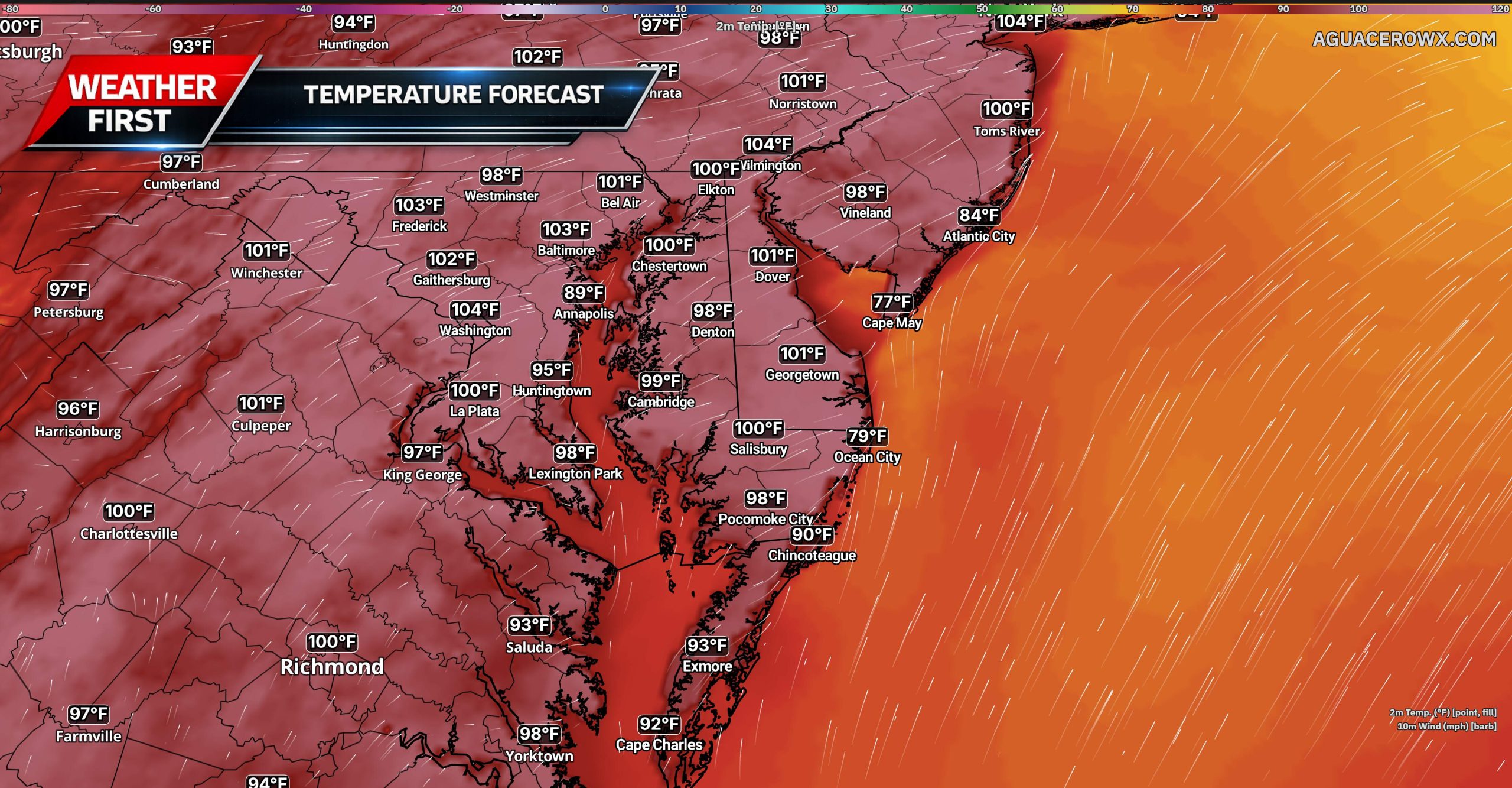

A stretch of above-normal temperatures begins today across the Mid-Atlantic and will continue through the end of the week, with Wednesday expected to be the hottest and most dangerous day. Extreme Heat Warnings and Heat Advisories are in effect across the region as temperatures and humidity climb.

An expanding area of high pressure over the central United States is building eastward toward the East Coast. At the same time, low pressure moving through eastern Canada will strengthen the flow of hot air into the region through Wednesday.

High temperatures today will range from the upper 80s to the mid-90s. Humidity will remain somewhat manageable, keeping most locations below dangerous heat thresholds. Heat index values could still reach the middle and upper 90s, especially from the Philadelphia area northward.

Conditions will become significantly hotter and more humid on Wednesday. High temperatures are expected to reach the middle and upper 90s, with some locations approaching or briefly reaching 100 degrees. The hottest conditions are expected along and southeast of Interstate 95, including much of Delaware, southern New Jersey and Maryland’s Eastern Shore.

Heat index values Wednesday afternoon are forecast to range from 100 to 109 degrees across much of the region. A westerly wind of 10 to 15 mph will likely prevent the sea breeze from moving very far inland, allowing temperatures at the Delaware and New Jersey beaches to climb into the middle and upper 90s. Heat index values near the coast could still reach 100 to 105 degrees.
Residents should limit strenuous outdoor activity, drink plenty of water and take frequent breaks in air-conditioned locations. Children and pets should never be left inside parked vehicles, even for a short period of time.

A mostly dry cold front is expected to move through the region late Wednesday. A few isolated thunderstorms could develop along the front, mainly across the Lehigh Valley, Poconos and northern New Jersey. Most of Delmarva is expected to remain dry.
The front will provide only limited relief. Thursday will remain hot, with highs in the upper 80s and 90s and heat index values potentially reaching the upper 90s to around 100 degrees along and southeast of Interstate 95. Additional Heat Advisories may be needed across southern portions of the region.
Friday should bring lower humidity as drier air moves southward, although temperatures may remain in the lower and middle 90s. Above-normal temperatures could continue into the weekend, even as the worst of the humidity temporarily eases.