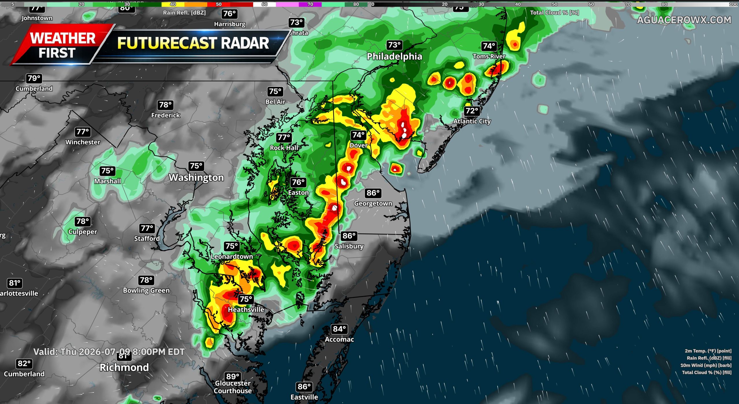

Showers and thunderstorms are expected to increase across the region this afternoon and evening, bringing the potential for heavy rainfall, localized flash flooding, and damaging wind gusts.

The setup comes as high pressure moves offshore this morning, allowing a warm and humid southerly flow to strengthen across the Mid-Atlantic. Dew points will climb into the low and mid 70s, making it feel muggy through the day. Afternoon temperatures should reach the mid 80s, but heat index values will climb into the upper 80s and lower 90s.

The main concern comes later today as low pressure approaches from the west and a mid-level disturbance moves into the region. This will provide enough lift to interact with a very moist and unstable air mass over the Delaware Valley, Delmarva, and southern New Jersey.

The atmosphere will be primed for storms, with instability values over 1,500 J/kg and precipitable water values between 2 and 2.5 inches. That means any storms that develop will be capable of producing very heavy rain in a short period of time. Rainfall rates of 1 to 2 inches per hour will be possible in the heaviest storms.

Because of the flash flooding concern, a Flood Watch has been issued for southeast Pennsylvania, northern Delaware, and portions of South Jersey from noon until midnight. While drought conditions remain across parts of the region, some areas have picked up recent rainfall, and repeated rounds of storms could overwhelm soils and drainage systems, especially in more urban locations.

The Weather Prediction Center has placed southeast Pennsylvania, southern New Jersey, Delaware, and the eastern shores of Maryland under a Slight Risk for excessive rainfall. A Marginal Risk extends farther north into the southern Poconos and northern New Jersey.
Severe weather is also a concern. The Storm Prediction Center has placed the Delaware Valley south of Philadelphia, Delmarva, and southern New Jersey under a Slight Risk for severe thunderstorms. A Marginal Risk extends from around Philadelphia north toward Allentown.
Damaging wind gusts will be the main severe weather threat. Wind shear values around 25 to 30 knots should support clusters of thunderstorms, with storms likely becoming outflow-dominant. This type of setup can produce strong wind gusts as storms organize and push eastward.

A few showers and storms may develop as early as noon to 2 p.m. across the western part of the region, but the main window for impacts is expected from 3 p.m. to 9 p.m. across the Delaware Valley, including Philadelphia, the eastern shores of Maryland, Delaware, and southern New Jersey. The highest potential for both damaging winds and localized flash flooding is expected generally south of Philadelphia.
Storms should gradually come to an end by midnight. A warm and muggy night will follow, with lows in the upper 60s to lower 70s. Patchy fog may also develop overnight, especially in areas that receive heavier rainfall.