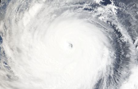

BEIJING — A powerful typhoon is spinning in the Pacific Ocean southeast of Taiwan, with forecasters warning it could rank as the most destructive storm to hit the region in years. Typhoon Bavi had winds approaching 200 kilometers per hour (124 mph) as of Thursday, though those winds eased slightly overnight.
China’s National Meteorological Centre says the storm, which spans roughly 1,000 kilometers (621 miles) at its widest — about the width of France — is expected to pass near northern Taiwan before making landfall along China’s eastern Fujian province Saturday evening.
Taiwan’s Central Weather Administration forecaster Jason Chang told Reuters that Bavi is on track to be the largest typhoon by size to hit Taiwan since 1987, calling storms of this scale “fairly rare in recent years.”
If the storm holds its current strength, commercial weather service AccuWeather says it would be the most intense typhoon — the term used for hurricanes in the Asia-Pacific region — since Super Typhoon Kong-rey in 2024.
AccuWeather international forecasting expert Jason Nicholls cautioned that while some weakening is expected beginning Thursday, the storm will remain a serious threat. “Some loss of wind intensity is anticipated starting Thursday, but Bavi will remain a dangerous storm as it impacts Taiwan and eastern China later Friday into Monday,” Nicholls said.
Taiwan’s President Lai Ching-te took to Facebook to urge residents to gather essential supplies, including food and flashlights. He also shared a video demonstrating how to assemble an emergency bag capable of sustaining a person for three days.
Japan’s weather agency issued warnings for Okinawa, the nation’s southernmost prefecture, alerting residents to stay on high alert Friday and Saturday for dangerous winds, flooding, landslides, and storm surges.
Scientists note that China, Japan, and Taiwan face growing exposure to extreme weather events tied to climate change. This year carries added concern because the anticipated arrival of El Niño could push temperatures higher and contribute to more frequent and stronger typhoons.
Xiangbo Feng, a tropical cyclone research scientist at Imperial College London, explained why Bavi is particularly worrying. “We should pay much attention to Bavi as it has spent a long time intensifying over the open Pacific, extracting energy from warm ocean and accumulating large amounts of moisture,” Feng said. He added, “When it would make landfall or get close to coastal regions, the damage could be catastrophic. A small change in Bavi’s track could have a significant influence.”