A more unsettled pattern is expected to develop across the Mid-Atlantic starting Friday and continuing into the holiday weekend, bringing the potential for afternoon and evening thunderstorms on top of the ongoing extreme heat.
A strong mid-level ridge responsible for the dangerous heat will begin to break down and shift back toward the south and west late this week. As that happens, troughiness will develop over the Northeast while several shortwaves ride over the top of the ridge and into the region. That pattern should support increasing chances for showers and thunderstorms Friday through Monday, with the greatest coverage currently expected Saturday through Monday.

Friday’s thunderstorm coverage is still expected to be somewhat limited, with storms mainly isolated to scattered during the afternoon and evening. However, the environment will be capable of producing strong to severe storms where development occurs. Temperatures near 100 degrees combined with dewpoints in the 60s will create strong instability, while large temperature and dewpoint spreads may allow storms to produce efficient damaging downburst winds. The Storm Prediction Center notes that clusters or linear segments could develop, especially across the northern Mid-Atlantic, where stronger flow aloft will be present.

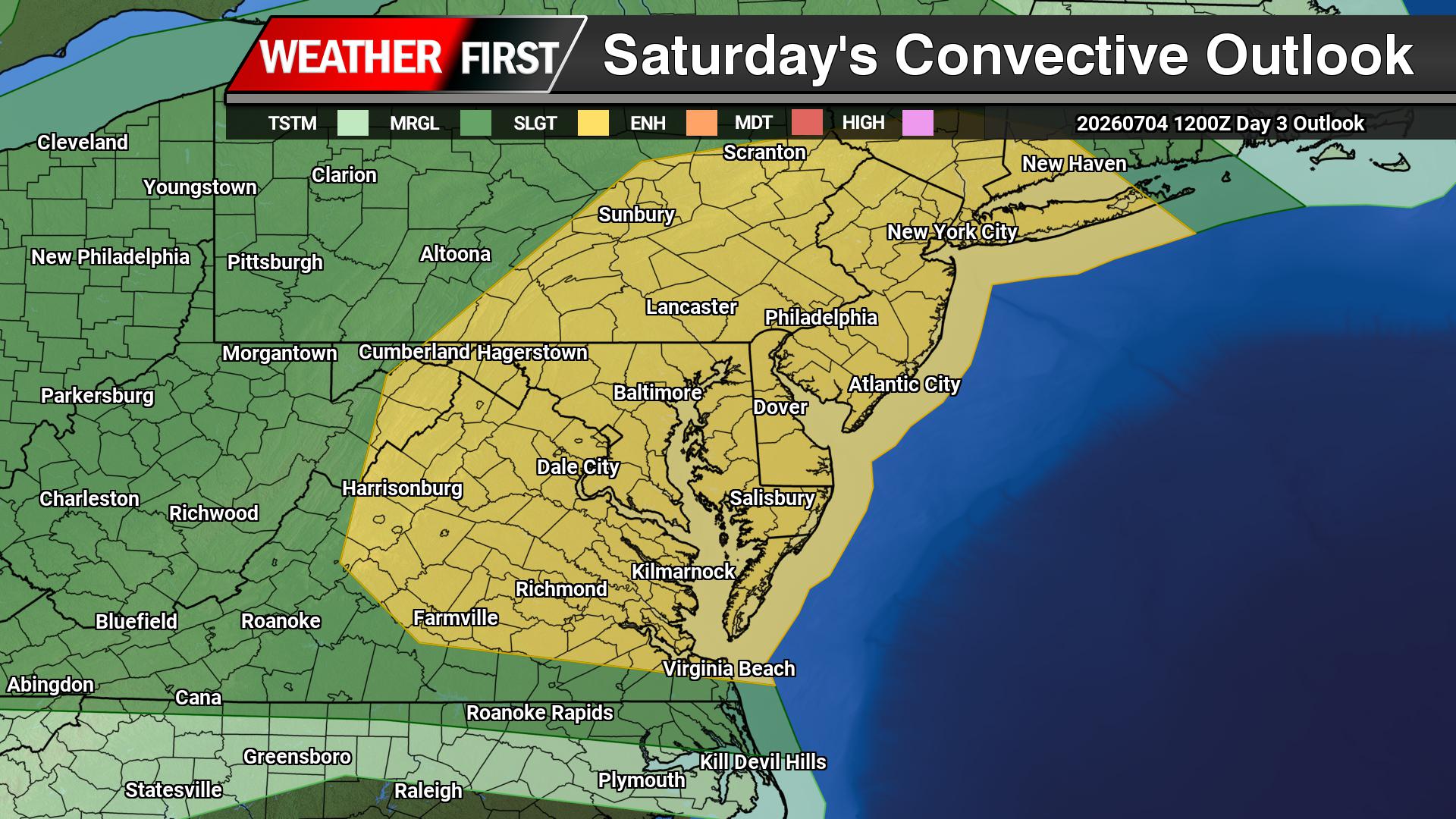
By Saturday, storm coverage is expected to become more widespread as a cold front and surface trough provide better forcing. Strong heating of a very moist air mass may support 3,000+ J/kg of MLCAPE by the afternoon. Even with weaker wind shear, low-level inverted-v profiles will favor strong to severe downburst winds. The SPC has placed parts of the Mid-Atlantic in a Slight Risk, level 2 out of 5, for severe thunderstorms Saturday, with damaging winds again the primary concern.

Sunday may bring even higher storm coverage as modest mid-level height falls approach the region and the surface front stalls nearby. The SPC has added a 15% severe risk for the Mid-Atlantic on Sunday, with damaging wind gusts continuing to be the main hazard.
The timing of storms each day will favor the afternoon and evening hours, which could create problems for outdoor holiday weekend plans, including cookouts, beach trips, fireworks events and travel. Not everyone will see storms each day, but any storm that does develop could quickly become strong with damaging wind gusts, frequent lightning and heavy downpours.
This severe weather threat will also come during a period of extreme heat. The National Weather Service Mount Holly briefing shows high temperatures through Saturday generally ranging from 95 to 105 degrees for most areas, with daytime heat index values between 100 and 110 degrees and isolated values up to 115 degrees possible. Overnight lows only falling into the mid 70s to low 80s will provide little relief.
Residents and visitors across Delmarva and the broader Mid-Atlantic should have multiple ways to receive weather alerts through the weekend. Outdoor plans should include a heat safety plan and a thunderstorm safety plan. When thunder roars, move indoors, and never take shelter under trees, tents or open pavilions during a storm.
Forecast details will continue to change, especially regarding storm coverage and placement each day, so check for updates before heading out for holiday weekend events.