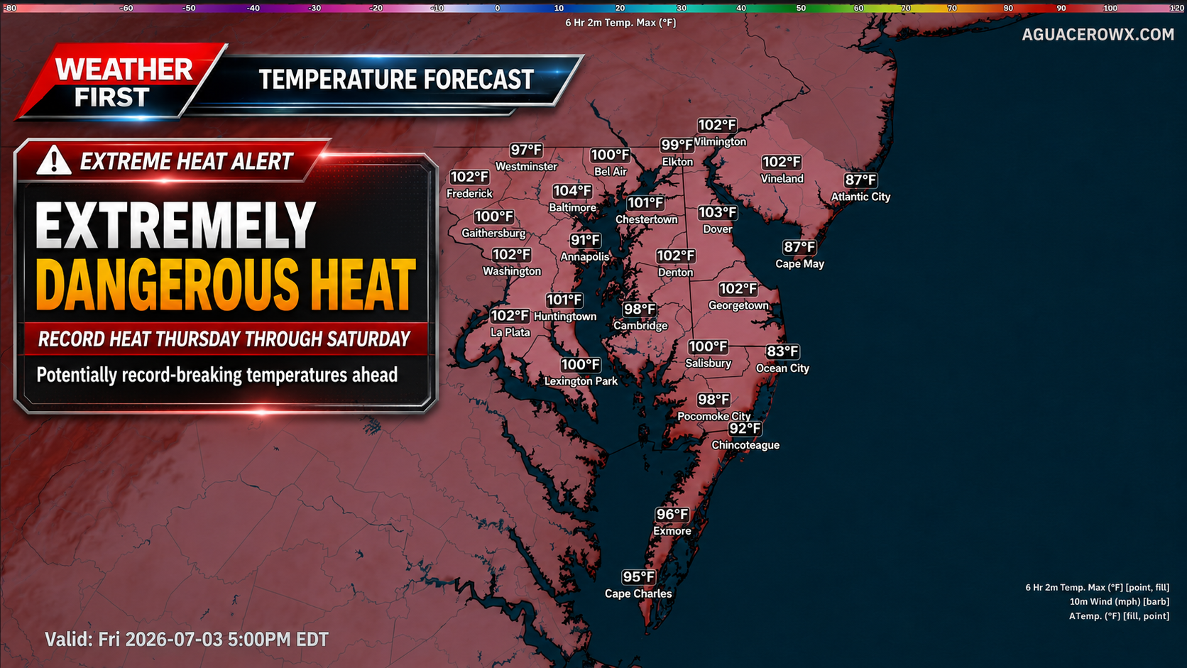
A potentially historic heat wave is set to build across the Northeast and Mid-Atlantic beginning Wednesday and lasting into the holiday weekend, with dangerous heat and humidity creating a significant risk for heat-related illness.

Strong high pressure in the mid-levels of the atmosphere is developing across the Mississippi Valley, Great Lakes and Ohio Valley early this week. That ridge will expand eastward into the Mid-Atlantic by Wednesday and remain in place through at least Saturday. This setup will allow temperatures to surge well above normal, with some locations potentially challenging all-time record highs Thursday and Friday.
High temperatures are expected to climb into the mid and upper 90s on Wednesday before reaching the 100 to 105 degree range Thursday and Friday. Heat index values will likely range from 100 to 110 degrees Wednesday, then increase greater than 110 degrees by Thursday and Friday.

The most intense heat is expected Thursday and Friday as winds shift more west to northwest. That flow will allow for better mixing of the lower atmosphere, lowering dew points somewhat during the afternoon but also helping temperatures climb even higher. Downsloping winds off the Appalachians may add additional warming, making this the type of pattern capable of producing record-breaking heat across the region.

The National Weather Service has upgraded the Extreme Heat Watch to an Extreme Heat Warning for southeastern Pennsylvania, northern Delaware and portions of New Jersey from Wednesday afternoon through Saturday. This includes areas where confidence is highest that heat index values will reach dangerous levels over multiple days.
For far southern New Jersey, the New Jersey barrier islands and Delmarva, an Extreme Heat Watch remains in effect from Thursday afternoon through Saturday. Heat index values may approach 100 degrees on Wednesday, but the more dangerous heat is expected to arrive Thursday and continue into Saturday.

While temperatures may ease slightly by Saturday, the heat will still be dangerous. Highs are forecast to remain in the mid 90s to near 100 degrees, with heat index values around 100 to 110 degrees. Even if some locations fall short of warning criteria by Saturday, the cumulative impact of several days of extreme heat will increase the risk for heat exhaustion and heat stroke, especially with outdoor holiday events and travel underway.

Some relief is expected by Sunday and Monday as the ridge begins to weaken and retreat southwest. However, highs may still remain in the low to mid 90s, with heat index values in the mid 90s to low 100s. The pattern change may also bring increasing chances for showers and thunderstorms during the holiday weekend.
This will be a high-impact heat event. Limit time outdoors during the afternoon and early evening, drink plenty of water, check on vulnerable neighbors and relatives, and never leave children or pets inside vehicles. Outdoor workers and anyone attending holiday events should take frequent breaks in shade or air conditioning.