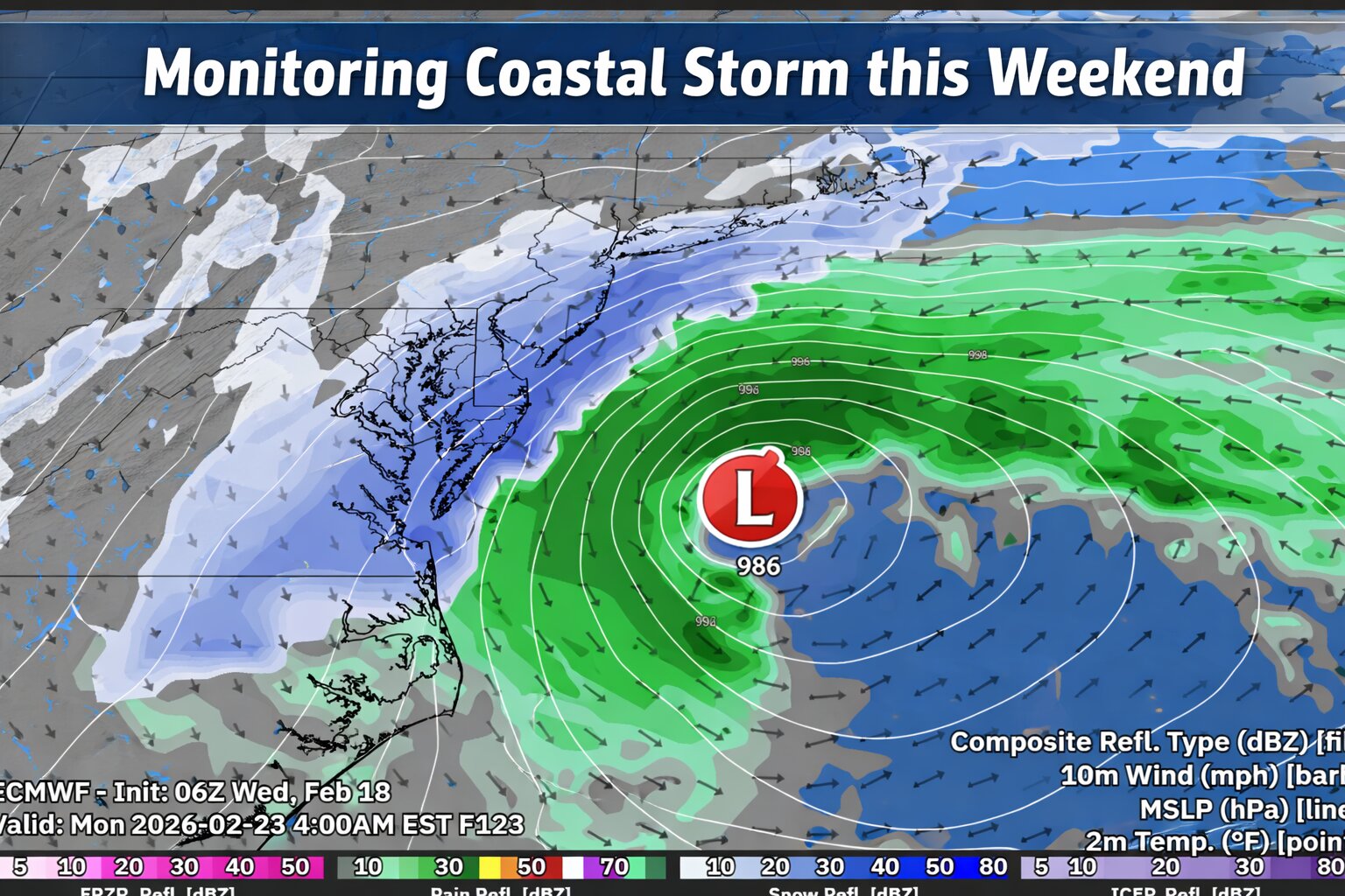
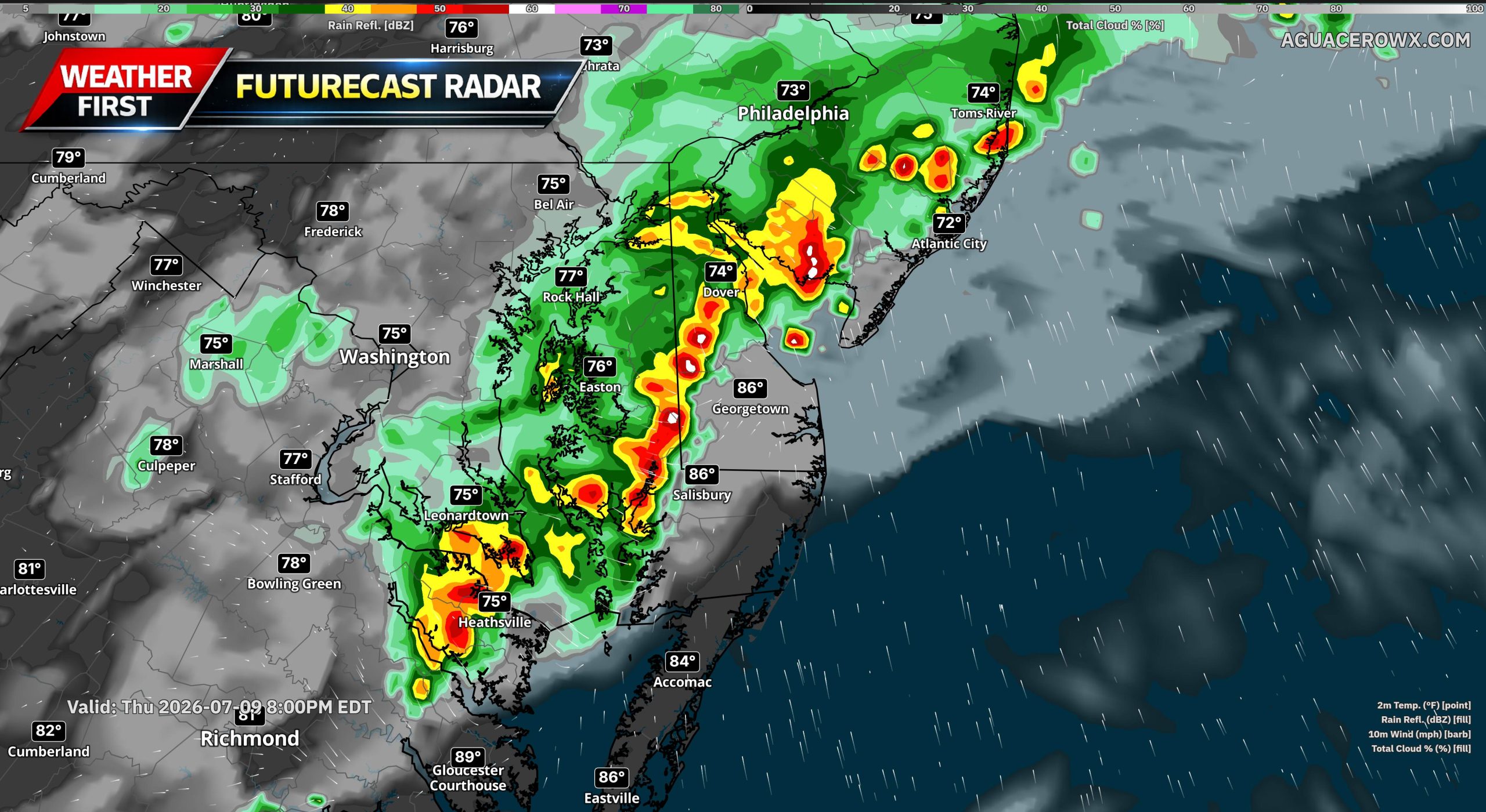
Tag: flooding

  • Potential Coastal Storm This Weekend; Much Colder Air Follows for Delmarva

    Potential Coastal Storm This Weekend; Much Colder Air Follows for Delmarva

    An active weather pattern continues across the Mid-Atlantic, and are now monitoring the potential for a coastal storm to impact the Delmarva Peninsula during the second half of the weekend.

    While details remain uncertain, confidence is increasing that a developing area of low pressure will track west to east across the region late Sunday before strengthening offshore along the northern Mid-Atlantic coast. But there is also key details I’m not very fond of trusting.

    Storm Track Will Determine Impacts

    Most computer models show a storm developing and passing near the region Sunday. However, the exact track and strength of the surface low will ultimately determine how impactful this system becomes for Delmarva.

    Recent trends in both deterministic and ensemble guidance have nudged the system slightly farther south and east. That shift could reduce overall impacts totals locally if it continues. Still, there remains a signal for a widespread precipitation event across the peninsula.

    If the storm tracks close enough to the coast, stronger dynamics could enhance precipitation rates. At this stage, it is too early to determine rain and even snowfall amounts or pinpoint exact impacts.

    Cold Air Will Be Key

    The amount of cold air in place ahead of and during the storm will play a major role in determining precipitation type and accumulation potential.

    Forecast guidance suggests that sufficient cold air may be present for accumulating snow across Delmarva if the storm tracks favorably. However, small shifts in the storm’s path could significantly change the outcome.

    Relying On a Norlun Trough & Dynamic Cooling Never Fair Well For Delmarva

    A Norlun trough is a narrow, elongated area of low pressure that can develop between two larger weather systems, often in New England or the northern Mid-Atlantic.

    These features often form in cold, unstable air behind a departing coastal storm or between competing pressure systems. They can be difficult to forecast because they are small-scale and highly sensitive to subtle atmospheric changes.

    On Delmarva, Norlun troughs are less common than in New England, but similar narrow deformation bands can produce comparable localized snowfall.

    Dynamic cooling refers to a process where strong upward motion in the atmosphere causes temperatures to cool rapidly, sometimes enough to change rain to snow.

    If precipitation falls heavily enough, it can also contribute to cooling through melting and evaporation, reinforcing the transition to snow.

    Much Colder Air Early Next Week

    Behind the potential weekend storm, a notably colder air mass is expected to settle into the region early next week.

    High temperatures Monday and Tuesday may struggle to climb out of the 30s across Delmarva, with overnight lows dropping into the teens in many locations. The colder conditions could lead to icy spots lingering if snowfall occurs over the weekend.

  • Rain Threat Increases Across the Mid Atlantic Through the Weekend

    Rain Threat Increases Across the Mid Atlantic Through the Weekend

    A prolonged period of unsettled weather is expected to impact much of the Mid Atlantic beginning later this evening and continuing through Sunday, bringing multiple rounds of rain and the potential for localized flooding concerns.

    Rain showers will begin moving into the region from west to east this evening as a mild and moisture rich weather pattern remains in place. While rainfall tonight is expected to be generally light to moderate, coverage will increase overnight and into Saturday as a stronger system approaches.

    More widespread rain is forecast for Saturday and Saturday night as deeper moisture moves into the Mid Atlantic. Periods of steady rain are likely, with occasional heavier downpours. Embedded isolated thunderstorms are also possible during this time, which could briefly enhance rainfall rates in some areas.

    By Sunday, additional rounds of showers are expected to continue, keeping soils saturated and rivers on the rise. While rainfall amounts will vary by location, several areas could see one to two inches of rain by the end of the weekend, with locally higher totals where heavier showers or thunderstorms occur.

    Delmarva Region Faces Elevated Rain And Water Concerns

    Across the Delmarva Peninsula, including Delaware, eastern Maryland, and the Eastern Shore of Virginia, the rain threat will become more pronounced overnight and persist through the weekend. Rainfall totals of one to two inches are likely across much of the region, with isolated higher amounts possible.

    The combination of steady rain, mild temperatures, and ongoing snow and ice melt farther north could lead to noticeable rises on rivers, streams, and creeks. Low lying and poor drainage areas may be especially susceptible to ponding of water, particularly during periods of heavier rain.

    While widespread flooding is not currently expected, localized minor flooding cannot be ruled out, especially if thunderstorms produce brief heavy downpours. Urban areas and locations near small waterways should remain alert for changing conditions.

  • Multiple Rounds of Rain Expected Across Delmarva This Weekend

    Multiple Rounds of Rain Expected Across Delmarva This Weekend

    The Delmarva region is expected to see several rounds of rain as a series of weather systems move through the area from late Friday into Sunday morning. While the rain will be spread out over time, confidence is high that most locations will see wet conditions at some point during the weekend.

    The first round of rain arrives late Friday into Friday night as a weakening cold front crosses the region. This front is associated with an area of low pressure moving from the Great Lakes toward eastern Canada. Because the front is weakening as it approaches Delmarva, it is not expected to bring much of a temperature drop or colder air. Rain during this period should generally be light to moderate.

    A stronger system moves in on Saturday as a slow moving trough dives south from Canada into the Great Lakes. This will help develop a new area of low pressure over the Lower Mississippi Valley that tracks northeast toward the Mid Atlantic. A warm front is expected to lift through Delmarva Saturday morning, placing the region in a warmer and more humid air mass. Temperatures are forecast to rise into the 60s, which is mild for this time of year, though still a few degrees shy of daily records.

    Heavier rain is expected later Saturday into Saturday night as a cold front moves through the region. There may be enough instability in the atmosphere for a rumble of thunder, but severe weather is not expected. After the initial front moves offshore Saturday night, scattered showers may linger until a secondary cold front passes through on Sunday morning.

    Once the secondary front clears the area, winds will increase, but the chance of wind gusts reaching advisory levels remains low. Overall, rainfall will be spread out over a 36 to 48 hour period with breaks between rounds.

    Forecast confidence is high that rain will occur, but exact rainfall totals remain uncertain. Most guidance suggests at least a half inch of rain, with some models indicating localized totals between 1.5 and 2 inches. The probability of receiving one inch or more of rain sits around 30 to 50 percent, while the chance of exceeding two inches is low.

    Despite the potential for moderate rainfall, flooding concerns remain minimal. The rain will fall gradually rather than all at once, and recent mild temperatures should have eliminated any lingering ice in creeks or rivers, allowing water to drain efficiently.

    More confidence in rainfall totals is expected as the weekend approaches, but residents across Delmarva should be prepared for several periods of rain from Friday afternoon through Sunday morning.

  • DEMA Mobilizes Delaware National Guard in Preparation for Coastal Storm Effects

    DEMA Mobilizes Delaware National Guard in Preparation for Coastal Storm Effects

    (SMYRNA, DE) — The Delaware Emergency Management Agency (DEMA) has announced the activation of the Delaware National Guard to support preparations and response efforts as the state faces threats from coastal flooding and strong winds expected to persist through tomorrow.

    Having coordinated with state and local officials since Friday, DEMA said it is strategically deploying Guard resources to where they will be needed most. Reception centers are already open across Kent and Sussex counties, with sheltering plans in place should demand increase. Agencies including the Delaware Department of Health and Social Services, DelDOT, and the American Red Cross are working closely with local authorities to facilitate access to these resources.

    In Bowers Beach, the mayor has issued a voluntary evacuation order for residents east of Whitwells Delight Road. Individuals needing shelter are guided to the Magnolia Fire Company or to contact the Kent County Emergency Operations Center at 302-735-3465 for further guidance.

    Reception Center Locations

    • Kent County: Magnolia Fire Hall, 2 North Main Street, Magnolia, DE
    • Sussex County: Millsboro Fire Hall, 109 E State St, Millsboro, DE

    DelDOT continues to monitor road conditions and post closures through its website and mobile app. Meanwhile, DNREC has closed beaches, surf crossings, and campgrounds at Delaware Seashore State Park and Cape Henlopen State Park until further notice.

    DEMA Director A.J. Schall commented, “We’re monitoring the situation and proactively positioning additional resources to support counties and municipalities in safeguarding residents. DEMA will continue to issue Watches, Warnings, and other directives as needed.”

    Officials warn that moderate-to-major coastal flooding, damaging wind gusts, tree damage, power outages, and roadway flooding remain possible. Additional local evacuations may be ordered if conditions worsen.


    Safety Guidelines for Residents

    1. Enroll in DENS – Sign up for the Delaware Emergency Notification System to receive alerts via phone or email.
    2. Know your zone – Use the Know Your Zone tool to determine whether your address falls within an evacuation zone. Stay alert even if you are outside a designated zone.
    3. Plan your evacuation – Outline a route, inform family members, and carry hard copies of important documents.
    4. Assemble an emergency kit – Include essentials such as medications, food, water, batteries, flashlights, and supplies for pets for 3–7 days.
    5. Stay informed – Monitor trusted media, state agencies’ social accounts, and radio stations for updates.
    6. Turn Around, Don’t Drown – Never drive through floodwaters.

    Emergency Alert Radio Stations: WDEL-AM 1150, WDEL-FM 101.7, WCHK-FM 101.3, WWTX-AM 1290, WRDX-FM 92.9, WJWL-AM 900, WDOV-AM 1410, WSTW-FM 93.7, WDDE-FM 91.1, WILM-AM 1450, WDSD-FM 94.7. Boaters should monitor Marine Channel 16

  • Strong Coastal Low Could Bring Major Impacts to Delmarva This Weekend

    Strong Coastal Low Could Bring Major Impacts to Delmarva This Weekend

    A powerful coastal low is forecast to develop off the Carolina coast late this week before strengthening and tracking northward this weekend. The system is expected to bring gusty winds, heavy rain, and coastal flooding to much of the East Coast — including the Delmarva Peninsula.

    The combination of strong onshore winds, high surf, and high astronomical tides could lead to significant coastal flooding across parts of Delaware, Maryland, and Virginia. The most widespread impacts are expected from Friday night through Sunday, with the highest risk during periods of high tide.

    Persistent onshore winds will also generate dangerous rip currents and high surf, likely leading to beach erosion along the Atlantic coastline and the lower Delaware and Chesapeake Bays. Coastal residents should closely monitor updates and follow any advisories issued by local emergency management or the National Weather Service.

    In addition to flooding, the storm could bring wind gusts over 45 mph, especially along coastal areas, which may result in scattered power outages and tree damage. Heavy rainfall could also lead to localized flooding inland, particularly in poor drainage areas.

    The Weather Prediction Center highlights the Delmarva coast as an area of elevated concern for strong wind gusts and coastal flooding potential this weekend.

    Residents are urged to stay alert as the system approaches and to secure outdoor items ahead of the storm.

  • Active Weather Pattern to Impact U.S. Late Next Week into the Weekend

    Active Weather Pattern to Impact U.S. Late Next Week into the Weekend

    An active weather pattern is set to affect much of the United States late next week and into the weekend, with strong weather systems expected to bring heavy precipitation, high winds, and potential drought conditions to various regions.

    The National Weather Service forecasts a strong surface low moving across the country, particularly impacting the central and eastern U.S. This will likely bring periods of heavy rainfall and high winds, while the Southern Plains may experience below-average precipitation and rapid onset drought conditions.

    Heavy Precipitation and High Winds Expected

    From late next week through the weekend, the East Coast will face a high risk (over 60% chance) of heavy precipitation. A broader moderate risk (40-60% chance) extends across much of the eastern U.S., with areas experiencing saturated soils potentially at risk for flooding. In the Northern and Central Plains, Upper Mississippi Valley, and Western Great Lakes, moderate snow accumulation is anticipated, along with high winds in many central U.S. states.

    The combination of snow and wind could cause disruptions to transportation networks, power outages, and tree damage. Meanwhile, regions across eastern New Mexico, western Texas, and southwestern Oklahoma are facing the threat of rapid drought development.

    Dry Conditions in the Southern Plains

    While much of the U.S. is set to see above-normal precipitation, parts of Texas and southwestern Oklahoma are forecast to experience below-average rainfall, which could intensify drought conditions. The persistent dry conditions and strong winds could increase the risk of significant wildfires in the area.

    Potential Impacts and Hazards

    The forecasted heavy precipitation could lead to flooding in areas still recovering from the aftermath of Hurricane Helene, particularly along the East Coast. As the storm system moves across the country, high winds may bring additional challenges, from power disruptions to transportation delays. The ongoing dry conditions in the Southern Plains also raise concerns about rapidly worsening drought and wildfire risks.

    As this active weather pattern unfolds, residents are encouraged to stay informed and prepare for potential disruptions.

  • Wash, Rinse, Repeat. Another High Wind Event On The Way

    Wash, Rinse, Repeat. Another High Wind Event On The Way

    Although the next storm system is another big one moving through the same areas as the last one, this one will not have that extreme punch like this one will. Still will be a nuisance to say the least.

    Strong winds will be a issue once again but thankfully we will NOT see those hurricane force wind gusts like we did but still in the higher end of the advisory category. Winds during the later overnight hours Friday into Saturday morning will gust 40-50 MPH on average but at times could gust 55 or higher especially near the coastlines. Which once again can lead to sporadic power outages and tree damage.

    Rainfall will once again will be a problem but not a extreme problem. A lot less rain is expected with this storm. Most areas will see upwards to a inch of rain but with saturated grounds, sporadic flooding is possible.

    Coastal Flooding will be a issue yet again with the New Moon still in play creating higher than normal tide cycles. At this time most tidal gauge forecasts are showing minor to moderate levels of tidal flooding Friday Night. Main flooding concerns will once again be in the Chesapeake and the mouth of the Delaware River.

  • Powerful Storm System Aims For Delmarva Tuesday Into Wednesday

    Powerful Storm System Aims For Delmarva Tuesday Into Wednesday

    Buckle up ladies and gentleman, tomorrow is going to be a very bumpy ride for us. Flooding rainfall, significant coastal flooding, and a serious high wind threat. And all of this begins during the afternoon hours Tuesday.

    Now we have been dealing with flooding since last month but what has me the most concerned is the absurd strength of these winds moving in tomorrow. A intense pressure gradient from a rapidly deepening surface low and strong high pressure system will generate a scenario of very intense winds. Strengthening of the low level winds in the low level jet-stream is some of the strongest I have seen for this region. Winds at 850-925mb level (<5000ft) screaming at 80-100 kts (92-115mph) is on the extreme end of likes I have not seen before. Now granted as we head down to the surface we are looking at reductions due to mixing but these winds are going to be fierce and nothing to play around with. My biggest concerns are for the southern and central portions of Delmarva where I believe we have a great shot of hitting hurricane force winds gusts at or exceeding 74 mph where the High Wind products are in place. Many locations will be seeing winds gusting 60 mph or greater at times. Power outages, downed trees, structural damage are all possible with these kinds of winds.

    Of course more flooding concerns for the region with the extremely saturated grounds from last months dump of 10-12 inches of rainfall. Another 2-4 inches are possible prompting a MDT risk from the WPC on excessive rainfall through the western shore of Maryland and northern Delmarva. Flood watches are in place in response to the heavy amounts of rainfall.

    Moderate to Major Flood Stage is expected across the Chesapeake Bay and the mouth of the Delaware Bay with the upcoming high cycles Tuesday Night and Wednesday. Some of which forecasts at certain tidal gauges could hit record levels! Atlantic coastal regions even though will have extremely large swell, winds will be parallel to the coast to keep tide levels down but will be funneling in significantly through the Chesapeake and Delaware Bay regions. Those who live near these water ways, make preparations to evacuate or seek higher ground if flood waters becoming inundating in your areas. Also make preparations to help protect your property from flood waters.

  • Significant Coastal Flooding / Damaging Winds Tues-Weds

    Significant Coastal Flooding / Damaging Winds Tues-Weds

    Next week’s storm is shaping up to be a very big problem going forward. A powerful 970-980mb low will rapidly develop as it moves into the Great Lakes running into a 1035-1040mb high pressure system (50-60mb difference) generating a major wind storm. Along with other problems like flooding rainfall of another 2-4 inches or more of rainfall.

    I am really starting to worry for our coastal communities come Tuesday Night. You have winds of 60 mph coming straight from the south and east onshore, generating swell 25 feet in the Gulf Stream, and astronomical high tides. That’s very bad news. Significant coastal flooding is in place with this scenario. Major beach erosion and inland flooding are going to be plentiful.

    Make preparations now ahead of time for sporadic power outages and dealing with flooding once again.

  • Snowfall / Rainfall Outlook Sat-Sun

    Snowfall / Rainfall Outlook Sat-Sun

    *** FIRST CALL SNOWFALL / RAINFALL OUTLOOK FOR SAT-SUN ***

    Been quite some time I’ve had to dust off this map but here we go ladies and gentlemen. North and West of the I-95 Corridor are in the zone for looking at some accumulating snow for this upcoming weekend. Mainly closer to the mountain ranges of the Appalachians. A range of 4 to up to 6 inches are possible through Frederick, Md and Westminster, MD. Mixing is also possible in those areas with temperatures hovering near 32 degrees which can shave some totals off slightly.

    Closer to I-95 will be dealing with snow starting off and mixing with rain and ice before changing to all rain towards the overnight hours Saturday. Greatly reducing snowfall totals for them. Extreme northern areas of Delmarva can see up to an inch of snow before melting and changing to all rain.

    Those across Central Delmarva, more unneeded rainfall is coming which could lead to some spotty areas of low lying flooding with 1 to 1.5 inches of rainfall.

    Winds will not be very bad with this storm but could gust 40-45 MPH along the coastal communities with areas of minor coastal flooding.

    This storm will only be a minor inconvenience before the bigger problem arises towards next week with significantly more amounts of rain and higher confidence of a damaging High Wind Event.

  • Minor To Moderate Flood Stage Coastal Flooding On Tuesday Returns

    Minor To Moderate Flood Stage Coastal Flooding On Tuesday Returns

    1 – Moderate coastal flooding and beach erosion are expected with Tuesday evening’s high tide in the Delaware counties of Sussex and Kent, and in the New Jersey counties of Cape May and Atlantic. For the remaining tidal area in Delaware and New Jersey, and for the tidal Delaware River and its tidal tributaries, widespread minor tidal flooding is anticipated at that time. Those areas are under a Coastal Flood Advisory. Spotty minor tidal flooding is possible through early Tuesday afternoon leading up to the time of the warnings and advisories, with lingering minor tidal flooding possible from late Tuesday night into Wednesday.

    2 – A northeast wind may gust as high as 40 mph at times into Tuesday along the immediate coasts of New Jersey and Delaware.

    3 – Gale Warnings are in effect for the Atlantic coastal waters of New Jersey and Delaware into Tuesday. Waves are expected to build to 8 to 12 feet.

    4 – An enhanced rip current risk and dangerous surf conditions are likely through much of the week.

    …COASTAL FLOOD WARNING REMAINS IN EFFECT FROM 4 PM THIS AFTERNOON TO MIDNIGHT EDT TONIGHT…

    * WHAT…One to two feet of inundation above ground level expected in low-lying areas near shorelines and tidal waterways.

    * WHERE…Kent and Inland Sussex.

    * WHEN…From 4 PM this afternoon to midnight EDT tonight.

    * IMPACTS…At this level, widespread roadway flooding occurs in coastal and bayside communities and along inland tidal waterways. Many roads become impassable. Some damage to vulnerable structures may begin to occur.

    * ADDITIONAL DETAILS…Spotty minor tidal flooding may occur through early Tuesday afternoon, with additional lingering minor tidal flooding possible from late Tuesday night into Wednesday.

    PRECAUTIONARY/PREPAREDNESS ACTIONS… Take the necessary actions to protect flood-prone property. If travel is required, do not drive around barricades or through water of unknown depth. && Time of high total tides are approximate to the nearest hour.

    Murderkill River at Bowers Beach MLLW Categories – Minor 6.6 ft, Moderate 7.6 ft, Major 8.6 ft MHHW Categories – Minor 0.9 ft, Moderate 1.9 ft, Major 2.9 ft Total Total Departure Day/Time Tide Tide from Norm Flood ft MLLW ft MHHW ft Impact ——– ——— ——— ——— ——– 26/07 AM 6.7 1.0 2.3 Minor 26/08 PM 8.3 2.6 2.6 Moderate 27/08 AM 6.8 1.1 2.0 Minor 27/08 PM 7.3 1.6 1.6 Minor 28/09 AM 6.6 0.9 1.3 Minor 28/09 PM 7.1 1.4 1.4 Minor Delaware Bay at Lewes MLLW Categories – Minor 6.0 ft, Moderate 7.0 ft, Major 8.0 ft MHHW Categories – Minor 1.3 ft, Moderate 2.3 ft, Major 3.3 ft Total Total Departure Day/Time Tide Tide from Norm Flood ft MLLW ft MHHW ft Impact ——– ——— ——— ——— ——– 26/06 AM 6.3 1.7 2.2 Minor 26/07 PM 7.6 3.0 2.4 Moderate 27/07 AM 6.3 1.7 1.8 Minor 27/08 PM 6.6 2.0 1.3 Minor 28/08 AM 5.9 1.2 1.0 None 28/09 PM 6.4 1.8 1.1 Minor

  • Tropical Troubles Into The Weekend

    Tropical Troubles Into The Weekend

    A big tone shift with the overnight model runs shows full speed ahead of a tropical system moving in from the Carolinas up into the Chesapeake Bay region. Which is the worst case scenario for any track of a storm system here on the shore.

    Many of the high resolution model guidance showing heavy rain beginning to move in starting in the evening hours on Friday from south to north as the winds start to increase from the east. Winds could be gusting as high as 50 mph along the coastlines with 40-50 for the inland locations. Along with the major waves coming ashore of 10-20 feet. Combination of a high tide cycle, heavy rainfall, strong long fetched onshore winds, coastal flooding is going to be a big problem.

    Early indications from a few days ago had flooding in the minor to borderline moderate levels. Well with high confidence now with the storm track and overall strength, moderate to potential major levels of coastal flooding exist for all water ways along the Atlantic, Delaware Bay, and of course the inland bays in Sussex, Kent and Worcester counties. Inundation of 1-3 feet are on the table on Saturday.

    Rainfall with tropical moisture is surely going to be a issue for areas along coastal Delaware down the Bay Bridge Tunnel. across the mid-shore we will average of 2 to 5 inches of rain. Highest for those farthest south and east.

    Now my least favorite topic, tornadoes. If we do have a tropical system on our hands rather than a hybrid or extra tropical cyclone, being on the right side of it is never a good thing. Slight curvature in the hodographs suggest we do have some turning in the atmosphere. Whether we have the little bit of instability remains to be in question. Tornadoes are a possibility but not with very high confidence right now.

    Prepare for a potentially major storm system heading into this weekend.

  • *** Hybrid Storm Expected This Weekend / Wednesday Update ***

    *** Hybrid Storm Expected This Weekend / Wednesday Update ***

    Confidence continues to increase for some sort of sub-tropical in nature storm system to develop along a stalled out frontal boundary off the coast of Florida and Georgia. With a strong area of high pressure it place towards New England, this will allow this system to intensify and move in towards the Carolina coastlines late Friday through Sunday.

    Overspreading heavy rain, gusty winds, and coastal flooding are all expected this weekend. Especially on Saturday when the conditions are expected to be the worst out of this storm. Whether this storm will be tropical in nature or not, impacts are going to be felt like a stronger nor’easter we would see in the winter months.

    Rain will begin to overspread the region beginning during the overnight hours on Friday and picking up in intensity on Saturday. Rain will be heavy at times with many operational and ensemble mean totals of 2-5 inches are expected over the weekend. With an area of high pressure to north, a strong pressure gradient will setup with constant strong onshore winds from the east and northeast. Sustained winds of 20-30 MPH with gusts 40-50 mph at times, will help generate waves offshore 10-20 feet. Near the coast, we are looking at swells generating 7-12 feet.

    With some of the the tide gauge forecasts as of now showing areas along the Atlantic Ocean and Inland Bay regions for Minor to even Moderate coastal flooding during the high tide cycle Saturday afternoon. I worry for the Inland Bays a lot more with all the water being forced with no where to go given how big the swells will be with the strong long fetched onshore winds.

    It’s pretty definitive at this point that we have a coastal storm on the way, it’s just a matter of how much rain will be associated with this system, and if it happens to be tropical or not. Or even a combination of both being a hybrid sub-tropical system. More details will be provided as the week goes on.

  • DNREC, DEMA Sponsor Delaware Flood Awareness Week

    DNREC, DEMA Sponsor Delaware Flood Awareness Week

    Governor John Carney has proclaimed May 9 through 13 Delaware Flood Awareness Week to inform residents about flood risk, likelihood of flooding from extreme weather events brought on by climate change, the importance of having a flood insurance policy, and flood remediation for property damage or loss. “Every Delawarean should make sure that they are prepared for unexpected flood events,” said Governor Carney. “Flood Awareness Week allows for federal, state and local emergency agencies to increase public awareness of flood risks. Explore the Delaware Department of Natural Resources and Environmental Control’s resources to make sure that you’re prepared.”

    Throughout next week DNREC and the Department of Safety and Homeland Security’s Delaware Emergency Management Agency (DEMA) will highlight numerous resources for flood awareness in Delaware, to include an interactive quiz, webinar and floodplain mapping tool.

    “Delaware is the lowest-lying state and has the lowest average land elevation in the country – we are already susceptible to flooding and becoming more at risk from sea level rise,” said DNREC Secretary Shawn M. Garvin. “With climate change spawning more extreme weather events, including hurricanes and tornadoes, flooding is an issue that we must confront with greater urgency. It’s imperative to get word out on flooding and flood risk management.”

    “Delaware is experiencing significant flooding with increasing frequency in areas that have not previously experienced flood events. We encourage residents to be proactive to understand how flooding could affect them and take the appropriate precautions to protect their property and families,” said Department of Safety and Homeland Security Secretary Nathaniel McQueen Jr.

    Much of the impetus behind Delaware Flood Awareness Week is helping the public become better informed about flood insurance, which provides policy holders with financial security and ensures quick recovery of personal property from flood damage. Delawareans can learn how much they know with a new interactive online flood quiz, available on Monday, May 9 from @DelawareDNREC social media pages. The quiz and much more information about flood awareness also can be found at de.gov/floodrisk.

    Much of the focus for Flood Awareness Week is on the tools and resources available to help Delawareans understand flood risk and be proactive addressing it on a personal property level. DNREC and DEMA staff will be on hand virtually and via social media during the week to explain flood insurance issues, to help residents access a flood insurance policy, and to advise on mitigation assistance resources in Delaware.

    On Tuesday, May 10, DNREC and the Federal Emergency Management Agency (FEMA) will host a flood insurance virtual open house, with two hour-long discussions, in the morning from 10 to 11 a.m. and an evening session from 6 to 7 p.m. The open house offers expert commentary from the state and federal level, and the private sector on flood insurance and Risk Rating 2.0, the National Flood Insurance Program’s (NFIP) new risk rating and pricing methodology. At the end of each open house, the panel will address general questions from attendees via Zoom chat. More information, including Zoom registration, can be found at de.gov/floodrisk.

    DNREC’s Floodplain Management program will drive more flood insurance and flood awareness outreach later this month, with a DART bus traveling Sussex County routes outfitted with a graphic depiction of a flooded Delaware community under the heading “FLOODS. Are You Prepared?

    The Wednesday, May 11 theme “Flood Safety” is highlighted by more social media and outreach from DEMA, carrying messages such as “Flooding Can Be Dangerous” and, particularly in Delaware, “Turn Around, Don’t Drown” when encountering flooded roadways – a typical passenger vehicle can be swept away toward a tragic outcome by as little as 12 inches of onrushing water.

    The flood awareness theme for Thursday, May 12 is “Know Your Flood Risk,” with a goal of encouraging Delawareans to research flood risk for their property. DNREC supports this effort by providing the Delaware Flood Planning Tool app, which can be found at de.gov/floodplanning. DNREC’s social media awareness message for the day is “Anywhere it rains, it can flood. Know your flood risk. Use the Delaware Flood Planning Tool to view other flood risk information for your property.”

    For the Friday, May 13, and the flood awareness theme of “Remediation and Mitigation,” DEMA will turn to social media for explaining how actions taken now can reduce Delaware’s vulnerability to future disasters – how, on average, $1 spent on hazard mitigation provides Delawareans $4 in future benefits. The theme extends to helping Delawareans understand the benefits of mitigating at the local level, including how they can apply for mitigation grants through their local communities.

    The finale for flood awareness week outreach efforts is a bonus for the next generation of Delaware property owners. DNREC’s Floodplain Management Program will unveil a working model of a floodplain Saturday, May 14 at the DNREC Division of Watershed Stewardship’s “Water Family Fest” at the James Farm Ecological Reserve that helps young people understand flooding and its impacts. The Enviroscape tabletop is a hands-on way to demonstrate flooding and floodplain management concepts – along with showing how flooding on the floodplain can be caused by unplanned development, and the role wetlands play in helping mitigate flooding impacts.

  • High Wind Event With Coastal Flooding Concerns Sunday Night

    High Wind Event With Coastal Flooding Concerns Sunday Night

    Not only we have to deal with some heavy rainfall, a little bit of snow for the northern areas of Delmarva and the Maryland Western Shore. There’s an event that is sleeping under the radar that has my full attention. When that low starts dropping below 990mb, that low level jet stream is very strong being pulled into this surface low.

    70-80kt Winds at 850mb ( Low Level Jet)

    Anytime I start seeing winds at 5000ft getting over 60kts, I get a bit uneasy in the damaging wind department. This is a long fetch stream of onshore winds we are talking about from the Gulf Stream. There is going to be a lot of wind energy pushing on the east side of this low. And it’s all onshore flow too. There’s more issues with this as well.

    Winds at the surface are showing widespread wind gusts of 40-60 mph from the east and southeast. Another problem surfaces as well. We have a high tide cycle that’s expected during the evening hours Sunday Night. To add more salt in the wound, this weekend is a full moon as well. So take 40-60mph surface winds, plus onshore flow, plus a high tide cycle, and a full moon, it’s not going to be a fun time for a coastal locations this weekend. Strongest winds appear to be in a window from 8pm Sunday until 4am Monday.

    Already a few tidal forecast in the region showing Moderate Flood Stage forecasts like this one in Crisfield. So we really got to watch our coastal regions Sunday night for flooding concerns.