A powerful and historic heat wave sweeping across the United States is putting a damper on Fourth of July celebrations, pushing event organizers in communities nationwide to cancel parades and postpone other Independence Day activities.
The dangerous temperatures are making it difficult — and in some cases impossible — to safely hold outdoor events that millions of Americans look forward to each year. As a result, organizers have been left with little choice but to alter or completely call off their planned festivities.
One year has passed since devastating floods tore through parts of the Texas Hill Country, and two neighboring communities are now telling very different stories about what recovery looks like.
Though the disaster struck the same general region, the two communities have each chosen a separate course in their efforts to rebuild and move forward from the destruction left behind.
The contrast between the two towns offers a striking look at how communities can respond in fundamentally different ways when faced with the same catastrophic event.
Happy Fourth of July, Delmarva! It’s going to be a scorcher out there today, so make sure you’re staying hydrated and cool. We’re looking at a high near 100°F with heat index values climbing as high as 105°F — that’s dangerous heat, folks. The morning and early afternoon will be sunny, but keep an eye on the sky after 5 PM. A 30% chance of showers and thunderstorms will develop ahead of tonight’s fireworks, and some of those storms could produce heavy rainfall. Light northwest winds around 5 mph won’t offer much relief from the heat.
Tonight, that storm chance continues as temperatures drop to a more comfortable 74°F. If your fireworks show is weather-delayed, stay patient and stay safe!
Looking ahead to Sunday, expect mostly sunny skies with a high near 90°F — still warm, but a noticeable step down from today. Another round of storms is possible Sunday evening and overnight.
Stay cool, stay safe, and enjoy your Independence Day, Delmarva! 🎆
The National Weather Service office in Mount Holly, New Jersey has issued an Extreme Heat Warning covering the July 4th holiday, beginning at 3:57 AM EDT and lasting until 8:00 PM EDT on July 4th.
An Extreme Heat Warning is the highest level of heat alert issued by the National Weather Service, indicating that dangerously hot conditions are expected that could pose a serious risk to public health.
Residents are strongly encouraged to stay indoors in air-conditioned spaces as much as possible during the warning period. If you must be outside, drink plenty of water, wear lightweight and light-colored clothing, and take frequent breaks in the shade or cool environments.
Health officials typically remind the public during extreme heat events to check on elderly neighbors, young children, and pets, as these groups are especially vulnerable to heat-related illness. Never leave children or animals in parked vehicles.
Cooling centers may be available in your area. Contact your local government or emergency management office for more information on nearby resources.
The National Weather Service office in Mount Holly, New Jersey has issued an Extreme Heat Warning effective July 4th, beginning at 3:57 AM EDT and lasting through 8:00 PM EDT that same evening.
Residents are advised to take the warning seriously, as extreme heat can pose significant health risks, particularly for vulnerable populations including the elderly, young children, and those with underlying health conditions.
Officials recommend staying indoors in air-conditioned spaces during peak heat hours, drinking plenty of water, and checking on neighbors and family members who may be at risk.
The warning remains in effect through the evening hours of the Fourth of July holiday.
Three people lost their lives and seven more were rescued Friday after a boat overturned on Geneva Lake during a powerful storm that tore through southern Wisconsin, according to a county official.
Tom Hausner, undersheriff for the Walworth County Sheriff’s Department, said the storm caused widespread damage across Walworth County — toppling trees, bringing down power lines, and damaging buildings. He added that many injuries were reported throughout the area.
Hausner said he did not have further details about those who died or the people who were rescued from the water.
Law enforcement in the city of Lake Geneva has taken over the investigation, Hausner said. Officials there did not immediately respond to requests for comment.
Lake Geneva Mayor Todd Krause declared a local emergency following the storm. In a statement, he noted that one person suffered minor injuries after being struck by a falling tree, and that several parts of the city were dealing with power outages.
Hausner said the county’s 911 center was flooded with calls from residents reporting storm damage, people trapped inside buildings, and requests for assistance. He said deputies moved quickly to respond, but were slowed down by downed power lines and trees blocking roads throughout the area.
“Power lines are all over the place. We are urging people to stay away,” Hausner said.
He said his department reached out to neighboring counties and the Wisconsin Department of Natural Resources for additional support.
Geneva Lake is a popular summer destination in southern Wisconsin, drawing visitors from the Chicago area and beyond. According to Hausner, the population of Walworth County — where the lake sits — nearly doubles on holiday weekends.
The storms, which moved through the Midwest on Friday afternoon and evening, forced multiple cities to cancel Fourth of July festivals and push back scheduled fireworks displays.
The National Weather Service issued a severe thunderstorm watch for the Lake Geneva area, forecasting heavy rain Friday with showers expected to linger into Independence Day and a continued chance of storms throughout the weekend.
The National Weather Service office in Mount Holly, New Jersey has issued an Extreme Heat Warning effective from 10:53 PM on July 3rd through 8:00 PM on the evening of July 4th.
The warning covers the region during what is typically one of the busiest outdoor holidays of the year. Residents planning to attend Fourth of July celebrations, cookouts, or fireworks events should be aware of the dangerous heat conditions expected throughout the day.
Health officials generally advise that during extreme heat events, people should drink plenty of water, wear lightweight and light-colored clothing, and limit strenuous outdoor activity — especially during the hottest parts of the afternoon. Those without air conditioning are encouraged to seek out cooling centers.
Extra attention should be given to elderly residents, young children, and pets, who are particularly vulnerable to heat-related illness. Never leave children or animals in parked vehicles.
Residents should monitor updated forecasts from the National Weather Service as the holiday approaches.
An Extreme Heat Warning has been issued by the National Weather Service out of Mount Holly, New Jersey, covering the area through much of the Fourth of July holiday.
The warning took effect late Thursday night at 10:53 PM EDT on July 3rd and is set to expire at 8:00 PM EDT on Friday, July 4th.
Residents are encouraged to stay hydrated, limit time outdoors during peak heat hours, and check on elderly neighbors, young children, and pets during the dangerous heat event. If you do not have air conditioning, consider visiting a cooling center in your area.
Officials typically remind the public that extreme heat is one of the leading weather-related causes of death in the United States. Taking simple precautions can be life-saving during conditions like these.
Travelers along Elderon Drive at the Loop should be prepared for intermittent lane closures as construction work continues in the area.
According to traffic officials, the lane restrictions are expected to remain in place until 12 p.m. Drivers are encouraged to use caution when passing through the construction zone.
No detour information was immediately available, but motorists are advised to allow extra time for their commute and remain alert for construction crews and equipment in the roadway.
Delaware State Police have arrested a 46-year-old Hockessin woman, Neha Gour, following a child abuse investigation tied to a Newark childcare facility.
The investigation was launched in late April 2026 by the Delaware State Police Criminal Investigations Unit after a child abuse allegation surfaced at the Delaware Technical Community College Stanton Childhood Development Center, located at 400 Stanton-Christiana Road in Newark.
The case came to light when a mother brought her young son in for medical care after noticing bruising on his wrist. As detectives reviewed the evidence, they determined that Gour — who was working as a teacher at the facility at the time — picked the 3-year-old up by the neck and placed him in a chair, causing the child to cry and reach for his neck. Investigators further found that Gour then grabbed the child forcefully by the wrist and pulled him to a different part of the classroom. Based on their findings, detectives secured an arrest warrant for Gour.
On June 30, 2026, Gour voluntarily surrendered at Troop 6. She was charged with Child Abuse Third Degree, a felony offense, and was subsequently arraigned in Justice of the Peace Court before being released on her own recognizance.
Maryland Governor Wes Moore spoke with NPR host Juana Summers about the meaning behind Martyrs Day, which falls on July 5th each year.
The day serves as a time to honor and remember individuals who gave their lives in the pursuit of equality and civil rights — a cause that continues to resonate across the country.
Governor Moore reflected on the importance of recognizing those sacrifices and the legacy they leave behind for future generations.
Delaware State Police are asking for the public’s help in locating four registered sex offenders who have failed to comply with state registration requirements, while also notifying residents about a recently homeless sex offender.
The Delaware State Police Sex Offender Apprehension and Registration Unit, known as SOAR, has issued wanted notifications for Gene Dukes, Charles Fulton, Dimitri Sudler, and Spencer Wright. Each of these individuals failed to either register or re-register at their current address as required by law.
Anyone with information about the whereabouts of these individuals is urged to call SOAR directly at (302) 739-5882. Tips can also be submitted anonymously through Delaware Crime Stoppers at (800) 847-3333. The four individuals named represent only a portion of the state’s current wanted sex offenders — the full list is available through the Delaware Sex Offender Registry website.
In a separate notification, SOAR is also informing the public that James McCray has recently been reported as homeless. McCray is not wanted for failing to register, but authorities want to know if anyone has information suggesting he is residing at a fixed address. If you have such information, contact SOAR at (302) 739-5882 or Delaware Crime Stoppers at (800) 847-3333.
McCray also represents only a portion of the currently identified homeless sex offenders in Delaware. The complete list can be found on the Delaware Sex Offender Registry website.
One year after a catastrophic flood devastated communities along the Guadalupe River in central Texas, residents of Kerrville came together to mark the grim anniversary of the disaster.
The occasion was a somber one, as those in the community paused to remember the death and destruction that the floodwaters unleashed on the region.
The Guadalupe River flooding left a lasting mark on Kerrville and surrounding communities, and Thursday’s remembrance reflected the weight of that loss still felt by those who lived through it.
The University of Maryland Eastern Shore bowling program is being celebrated for more than just its performance on the lanes — the team is earning high marks in the classroom as well.
The National Tenpin Coaches Association has recognized the UMES bowling team as having the second-highest team grade point average among all NCAA programs for the 2025-26 academic year.
The honor highlights the dedication of the student-athletes on the Hawks roster, who have balanced the demands of collegiate competition with strong academic performance throughout the school year.
Drivers heading along Sutton Place should be prepared for a slowdown as a flagging operation is currently underway in the area.
The traffic control operation affects the stretch between E Sutton Place eastbound and W Sutton Place, where flaggers are directing vehicles through the area.
The flagging operation is expected to remain in place until 5 PM. Motorists are encouraged to allow extra travel time or consider alternate routes if possible.
Walker School Road is currently closed to traffic in both directions as construction work gets underway in the area.
The closure affects the segment of Walker School Road running between Gum Brush Road and Saw Mill Branch Road. Drivers traveling through that corridor will need to find an alternate route.
The road is expected to remain closed throughout the duration of the construction project, with the reopening scheduled for October 24th, 2026.
Motorists are encouraged to allow extra travel time and plan ahead when driving in the area.
A dangerous heat wave threw a wrench into Fourth of July festivities across much of the central and eastern United States on Friday, as officials scrambled to cancel or postpone dozens of parades, concerts, and fireworks shows while the nation celebrated its 250th anniversary.
Among the events disrupted was the Great American State Fair on the National Mall in Washington — a key part of President Donald Trump’s plans to commemorate the country’s 250th birthday. The fair temporarily shut its doors Friday afternoon as temperatures climbed to 101 degrees Fahrenheit (38 degrees Celsius). Organizers said they planned to reopen at 5 p.m., weather permitting, with added safety measures including cooling tents and misting stations.
Record-setting temperatures had moved into the eastern part of the country from the Midwest earlier in the week. The National Weather Service reported that more than 185 million people were under heat alerts on Friday, with heat index values potentially climbing as high as 115 degrees Fahrenheit (46 degrees Celsius) in many areas.
Forecasters and government officials warned that the extreme heat could turn deadly. They urged anyone spending time outdoors during the Fourth of July weekend to drink plenty of water, find shade when possible, and be alert to warning signs of heat-related illness.
Event cancellations were reported across at least seven states. Among the most notable was a major Independence Day parade in Philadelphia, along with events in Takoma Park, Maryland, and Loudoun County, Virginia.
The National Weather Service office in Mount Holly, New Jersey has issued a Severe Thunderstorm Watch for the area, beginning at 3:36 PM EDT on July 3rd and remaining in effect until 11:00 PM EDT that same night.
A Severe Thunderstorm Watch means conditions are favorable for the development of severe thunderstorms across the watch area. Residents should remain alert and be ready to take shelter quickly if a warning is issued.
Meteorologists urge people to stay weather-aware throughout the evening hours. Have a plan in place, keep devices charged, and monitor local forecasts for any updates or upgraded warnings as storms develop.
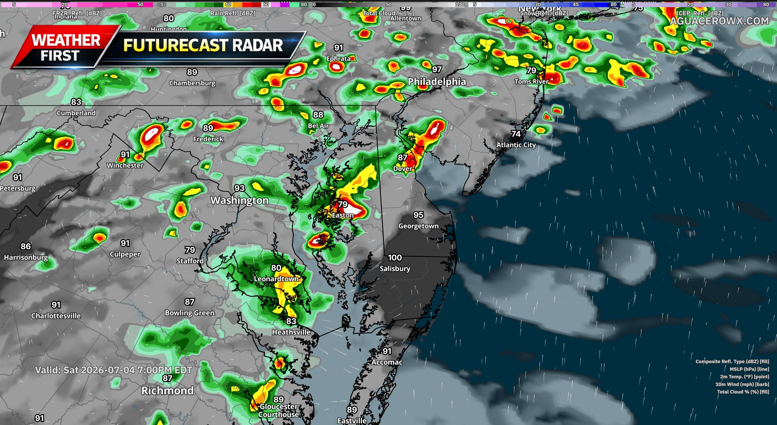
A more active weather pattern is expected to develop across Delmarva and the surrounding Mid-Atlantic through the holiday weekend, bringing increasing chances for afternoon and evening showers and thunderstorms. This comes as dangerous heat and humidity continue to impact the region, adding another concern for outdoor plans and holiday festivities.
The large ridge of high pressure responsible for the extreme heat is beginning to break down and shift back to the south and west. As this happens, a mid-level trough will dig southeastward into New England, allowing several disturbances to ride over the top of the ridge and move into the region. These disturbances will help trigger more showers and thunderstorms, especially during the afternoon and evening hours.
Storm chances will begin to increase late today, though coverage should remain more isolated to scattered. Rain chances are around 20 to 30 percent for this afternoon and evening. By Saturday, storm coverage should become a bit more widespread, with rain chances generally ranging from 30 to 60 percent. The most active period looks to arrive Sunday into Monday, when showers and storms could become more widespread across much of the area.
The Storm Prediction Center has placed portions of the region under a Slight Risk, level 2 out of 5, for severe thunderstorms today, Saturday, and Sunday. While storm coverage may be limited today, any storm that develops could become strong. By Saturday, storms may become more organized, with damaging wind gusts being the primary severe weather threat.
Sunday could bring a more focused severe weather risk across Delmarva as the atmosphere becomes unstable ahead of an approaching cold front. While the entire region may see showers and thunderstorms, Delmarva may have the better chance for stronger storms depending on how much heating and instability can develop during the day.
The timing and coverage of thunderstorms remains somewhat uncertain, but the main message is that holiday weekend plans could be impacted at times by storms, especially during the afternoon and evening. Anyone with outdoor events, beach plans, fireworks, or travel should stay weather aware and have a way to receive warnings.
After the cold front moves through Sunday, it may stall near or just south of the region. That stalled boundary, combined with another upper-level disturbance moving through, could lead to scattered to widespread showers and a few thunderstorms Sunday night through Monday night. Even after that, isolated daily storm chances may continue into the middle of next week, mainly during the afternoon and evening.
Along with the storm threat, dangerous heat remains a concern through Saturday. Heat index values could still climb into the 100 to 108 degree range Saturday, especially across inland areas. The combination of extreme heat, high humidity, and scattered storms will make it important to take precautions, stay hydrated, limit strenuous outdoor activity, and move indoors quickly when thunder is heard.
An Extreme Heat Warning has been issued by the National Weather Service out of Mount Holly, New Jersey, covering the area through the Fourth of July holiday.
The warning took effect on Thursday, July 3rd at 1:40 PM Eastern Time and is set to expire on Friday, July 4th at 8:00 PM Eastern Time.
Extreme Heat Warnings are issued when dangerously high temperatures pose a significant risk to public health. Residents should take steps to stay cool, stay hydrated, and check on vulnerable neighbors, elderly family members, and those without access to air conditioning.
If you must be outdoors, limit strenuous activity to the cooler morning hours and seek shade whenever possible. Never leave children or pets unattended in vehicles.
An Extreme Heat Warning has been issued by the National Weather Service out of Mount Holly, New Jersey, signaling a dangerous heat event for the area.
The warning took effect at 1:40 PM EDT on Thursday, July 3rd and is set to expire at 8:00 PM EDT on Friday, July 4th — meaning the dangerous conditions are expected to continue through much of the Independence Day holiday.
Residents should take steps to protect themselves from the extreme heat, including staying indoors in air-conditioned spaces, drinking plenty of water, and checking on elderly neighbors and relatives. Pets should not be left in vehicles, and outdoor activities should be limited during the hottest parts of the day.
A raging wildfire burning southwest of Denver has driven thousands of residents from their homes and leveled more than 160 structures as of Friday, with unpredictable winds spreading the flames across two Colorado counties.
Known as the Aspen Acres fire, the blaze is one of approximately 40 large wildfires currently burning out of control, mostly across the western United States. Months of dry weather and historically low snowfall this past winter in some areas have created dangerous fire conditions.
Firefighters have been pulling water directly from the Pueblo Reservoir in their efforts to battle the blaze, which grew by 17 square miles — roughly 44 square kilometers — overnight. By Friday, the fire had reached nearly 105 square miles (272 square kilometers) in size with zero containment reported.
The Pueblo County Sheriff’s Office announced mandatory evacuations for all of Colorado City, an unincorporated community of approximately 2,200 people, along with the towns of Beulah, Rye, and San Isabel.
Around 50 National Guard soldiers were deployed Friday to assist with staffing road checkpoints throughout Custer and Pueblo counties. Guard members are also supporting State Park Rangers, who have added boats to keep recreational watercraft away from areas where aircraft are scooping water.
Meanwhile, on the western slope of the Rocky Mountains, crews have achieved roughly 65% containment of the Snyder Fire along the Colorado-Utah border. That fire drew national attention last weekend after three members of a Helitack team were killed and two others were injured when they were overtaken by flames.
Elsewhere in the region, the Cottonwood fire in southwestern Utah had grown to more than 147 square miles (380 square kilometers) by Friday, while the Babylon fire in the southeastern corner of the state had reached 133 square miles (344 square kilometers).
Travelers heading southbound on Delaware Route 1 are facing lane restrictions after a crash forced the closure of the right lane near Exit 136.
The incident is currently affecting traffic flow in that stretch of the highway. Drivers approaching the area are urged to slow down, stay alert, and be prepared for potential delays.
No additional details about the crash have been released at this time. Motorists are encouraged to allow extra travel time or consider alternate routes until the lane is reopened.
With the United States marking its 250th Independence Day, the New Castle County Division of Police is calling on residents to keep safety top of mind as the holiday celebrations get underway.
Whether your plans include a backyard barbecue, quality time with family, or heading out to watch a professional fireworks show, law enforcement wants Delawareans to remember one important fact: fireworks are regulated in the state of Delaware.
Police say that taking a moment to understand the law before the festivities begin could go a long way toward making sure the holiday stays fun — and safe — for everyone involved.
A collision on Delaware Route 1 southbound has resulted in the closure of the right lane in the vicinity of Exit 136, according to state transportation officials.
Drivers heading southbound on DE-1 should be prepared for potential delays as crews work in the area. Motorists are urged to slow down, stay alert, and allow extra travel time when passing through the affected zone.
No additional details regarding the nature of the crash or any injuries have been released at this time. TV Delmarva will continue to monitor the situation as more information becomes available.
A vehicle fire has prompted the closure of the Boxwood off-ramp on Route 141 northbound, according to traffic officials.
Drivers traveling in the area are advised to use alternate routes until the situation is resolved. No further details regarding the fire or a timeline for reopening have been provided.
Motorists should remain alert and allow for extra travel time as crews work to address the incident.
Northbound travelers on Coastal Highway, also known as Delaware Route 1, should expect a slow commute between Rehoboth Avenue Extension and Camelot Drive.
According to traffic officials, congestion in that corridor is currently causing delays ranging from five to ten minutes for drivers moving in the northbound direction.
No additional details about the cause of the backup were provided. Drivers are encouraged to allow extra travel time or consider an alternate route until conditions improve.
Southbound travelers on Coastal Highway (Delaware Route 1) should expect a slowdown between John J. Williams Highway (Delaware Route 24) and Rehoboth Avenue Extension.
According to Delaware Department of Transportation, heavy congestion in the area is causing delays of approximately 5 to 10 minutes for drivers moving through that corridor.
Motorists are encouraged to allow extra travel time or seek an alternate route to avoid the backup.
Tropical Storm Maysak made landfall along the southwestern coast of China’s Hainan island province on Friday evening, unleashing winds of up to 23 metres per second — roughly 51 miles per hour — and triggering widespread transportation shutdowns across the region.
China’s National Meteorological Center reported the storm came ashore at approximately 6:20 p.m. local time, which is 10:20 a.m. GMT.
In addition to Hainan, the storm is forecast to dump heavy rain on Guangdong, Guizhou, and Hunan provinces, as well as the Guangxi region. Some parts of Hainan could receive as much as 350 millimetres of rainfall within a single 24-hour period, according to the national weather forecasting agency.
State broadcaster CCTV reported that Hainan’s Sanya Phoenix International Airport halted all takeoffs and landings beginning at 5 p.m., following the earlier cancellation of 92 flights by 11:30 a.m. All round-island high-speed rail services were also shut down for the day.
Ferry crossings across the Qiongzhou Strait were suspended starting at 2 a.m. and are expected to remain out of service for one to two days.
Officials called on authorities to intensify monitoring efforts and carry out evacuations from vulnerable areas, describing the flood prevention situation as “severe and complex.”
Good morning, Delmarva! If you’re heading outside today, make sure you’re prepared for some serious heat. We’re looking at a scorching high near 103°F this afternoon, with heat index values potentially reaching 110°F — that’s dangerously hot. A light northwest wind at 5 to 10 mph won’t offer much relief under mostly sunny skies. Please stay hydrated, limit outdoor activity during peak afternoon hours, and check on elderly neighbors and pets.
Tonight, we’ll see a slight break with isolated showers and thunderstorms possible before skies clear out. Temperatures will only drop to around 81°F overnight — still quite warm.
Looking ahead to Independence Day tomorrow, expect another hot one with highs near 100°F. Scattered showers and thunderstorms will develop during the afternoon and evening, so keep that in mind for any Fourth of July celebrations — have a backup plan ready! Saturday night stays unsettled with showers and storms lingering.
Stay cool, stay safe, and enjoy the holiday weekend, Delmarva! I’ll see you back here for your next update.
A vehicle crash has forced the closure of multiple lanes on DuPont Boulevard at the intersection of Lazy Lagoon Road, according to transportation officials.
Motorists traveling through the area are advised to use caution and allow for extra travel time. Alternate routes are encouraged as crews work at the scene.
No additional details regarding injuries or the number of vehicles involved have been released at this time. Drivers should stay alert for emergency vehicles and traffic control personnel in the area.
Ratledge Road is closed between Coale Lane and Summit Bridge Road following a tree that has come down across the roadway.
Motorists traveling in that area are advised to seek an alternate route and allow extra time for their commute. Crews are expected to work to clear the obstruction, though no estimated time of reopening has been provided at this time.
Drivers should use caution near the affected area and watch for any traffic control measures that may be in place.
An Extreme Heat Warning has been issued by the National Weather Service out of Mount Holly, New Jersey, beginning at 3:19 AM on July 3rd and lasting through 8:00 PM on the evening of July 4th.
This type of warning is reserved for the most dangerous heat conditions, when high temperatures and humidity combine to create life-threatening situations. Residents should take steps to stay cool, stay hydrated, and check on vulnerable neighbors, family members, and pets during the duration of this warning.
Officials recommend limiting time outdoors during peak afternoon hours, seeking air-conditioned spaces when possible, and never leaving children or animals in parked vehicles.
An Extreme Heat Warning has been issued by the National Weather Service office in Mount Holly, New Jersey, covering the area through the Fourth of July holiday.
The warning took effect in the early morning hours of July 3rd at 3:19 AM EDT and is set to expire on July 4th at 8:00 PM EDT, meaning dangerous heat conditions are expected throughout the holiday period.
Extreme Heat Warnings are issued when dangerously hot conditions pose a significant risk to public health. Officials typically advise residents to stay indoors in air-conditioned spaces, drink plenty of water, check on elderly neighbors and relatives, and avoid prolonged exposure to the sun during the hottest parts of the day.
Anyone experiencing symptoms of heat-related illness, such as heavy sweating, weakness, dizziness, nausea, or confusion, should seek medical attention immediately.
HONOLULU (AP) — Residents of U.S. territories in the western Pacific are preparing for what could be another super typhoon, arriving just months after the most powerful tropical cyclone on the planet this year already tore through the region.
In the U.S. Commonwealth of the Northern Mariana Islands, electricity has still not been fully restored following Super Typhoon Sinlaku, which unleashed violent winds and heavy rainfall back in April. Some displaced residents continue to live in tents after their homes were completely destroyed.
“We’re getting ready to do this all over again,” said Edwin Propst, a former lawmaker who now works in the governor’s office on Saipan, where it was already Friday. “The timing is terrible.”
Typhoon Bavi is expected to intensify into a super typhoon by Sunday night through early Monday, which is when it is projected to arrive in the Marianas, according to Paul Stanko, a senior meteorologist with the National Weather Service based in Guam.
A tropical cyclone earns the designation of super typhoon when its maximum sustained winds reach at least 150 mph (241 kph). Stanko noted that super typhoons are comparable to a high-end Category 4 or Category 5 hurricane.
As of Friday, Bavi was located 760 miles (1,223 kilometers) east of Guam, carrying maximum sustained winds of 80 mph (129 kph), according to the weather service.
Stanko said some residents are actually hoping the storm tracks toward Guam rather than the Northern Marianas, which would give the harder-hit islands more time to recover from Sinlaku.
“That’s what we’re actually hoping for because then Saipan wouldn’t get it as bad,” Stanko said.
Propst said he was hearing the same sentiment from people on Guam as well.
“That’s so island-style,” he said. “God bless them for saying that.”
Guam lies west of the International Date Line and carries the nickname “Where America’s Day Begins” because it is several hours ahead of Hawaii, Alaska, and the continental United States. The island is also home to two major U.S. military installations.
Propst said residents were boarding up windows with plywood and stockpiling gasoline, recalling how gas station lines stretched on for weeks following Sinlaku.
The Rev. Francis Hezel, assistant pastor of Santa Barbara Catholic Church in Dededo, Guam, said he hopes no island takes a direct hit from the storm. Having lived through many typhoons, he said he wasn’t overly alarmed and remained hopeful that Bavi would shift course.
“Right now the pattern is heading towards us, but those patterns change,” he said.
Even so, church staff and community members were taking precautions.
“This is getting to be the normal thing now, typhoon preparedness,” Hezel said. “It’s happening more frequently.”
El Niño conditions are known to ramp up hurricane activity in the Pacific. Scientists say the El Niño warming cycle, combined with a planet already heating up due to fossil fuel emissions, is likely to intensify extreme weather events around the world.
Although Sinlaku caused no deaths on land, Propst said the community continues to grieve the six crew members of a cargo ship that capsized during the storm. Searchers recovered one body, but the U.S. Coast Guard called off the search — which had lasted more than 100 hours — before the remaining crew members were found.
Propst acknowledged that recovery from Sinlaku has come a long way, but said the islands are “not quite there yet.”
“A few more months would have been good,” he said.
Escaping the heat this Fourth of July weekend will be no easy feat for millions of people in the eastern United States, with some communities already scrapping or scaling back their Independence Day festivities because of dangerous conditions.
The National Weather Service issued a warning Thursday that hazardous, record-setting heat will continue across much of the central and eastern U.S. through Friday, with the East Coast expected to remain in the grip of extreme temperatures through the weekend. Forecasters called for highs in the upper 90s Fahrenheit across the Northeast, and both New York City and Boston hit 100 degrees on Thursday. When humidity is factored in, conditions will feel even more punishing — putting a damper on celebrations marking 250 years of American independence.
“Anywhere you go in southern New England, you will be dealing with dangerous heat today, tomorrow and Saturday,” said Bryce Williams, a meteorologist with the National Weather Service.
In Boston, organizers pushed back the gates-open time for the Boston Pops Fireworks Spectacular from noon to 4 p.m. on Saturday due to the heat. Philadelphia officials shortened the route of a Thursday morning parade, scrapped an afternoon all-American Block Party, and delayed the start times of an evening picnic and concert at Independence Mall.
In Lower Windsor Township, Pennsylvania, an America 250 celebration that was to include food trucks, games, and the highway department’s dump truck has been moved to July 8. Norristown, Pennsylvania canceled its Saturday parade entirely, citing concerns for the safety of residents, participants, and first responders — though evening fireworks and an afternoon event with games, food, and music are still set to take place.
“The parade is one of our community’s most beloved traditions, and we share in the disappointment of its cancellation, especially as we celebrate America’s 250th birthday,” said Interim Municipal Administrator Jayne Musonye.
Gettysburg National Military Park in Pennsylvania relocated outdoor programming to indoor venues. Amtrak also canceled several train routes Thursday due to the heat, including Acela service between Boston and Washington, and warned that other trains could run at reduced speeds, causing delays through Saturday.
A heat dome — a high-pressure system that traps heat and humidity over a region — has been bearing down on areas stretching from the Midwest to the East Coast. Beyond holiday events, officials in many communities have opened cooling centers for residents seeking relief. In Boston, several air-conditioned museums are offering free admission to city residents, while pools and waterparks in Providence, Rhode Island have extended their hours.
At a Philadelphia Phillies home game against the Pittsburgh Pirates on Wednesday, the temperature had already climbed to 98 degrees by first pitch. Sixteen pallets of bottled water were handed out to fans at no charge.
Bill Christy, 69, of Philadelphia, was making his way through the heat with two teenagers he had brought along for company. “They’re young, they can handle it,” he said. “I’ll just go up in the shade somewhere if I get hot.”
Nearby, a fife and drum corps was marching through the lower concourse in full uniform. “Usually it’s wool regimental. But this is linen, it’s cool,” said Debbie Mayes of Ewing, New Jersey, a member of the Washington Crossing Fife and Drums. “We’re fine. They’ve been very kind to us, letting us take breaks and providing water.”
In New York City, Taylor Swift fans were braving the heat outside Madison Square Garden, hoping to catch the superstar before her Friday wedding. Amanda Powell, visiting from Little Rock, Arkansas, admitted the conditions were tougher than expected. “It’s super hot,” she said. “Being from Arkansas, we thought we could handle the heat, but it’s been very warm.”
Central Park in Manhattan reached 100 degrees Thursday afternoon — the first time the famous park has hit triple digits since 2012, according to the National Weather Service.
At the Franklin Park Zoo in Boston, staff worked hard to keep animals comfortable in the extreme heat. Workers gave African penguins frozen blocks of ice packed with herring, offered frozen pellets to Nigerian dwarf goats, and tossed frozen treats into the enclosure of Western lowland gorillas, who eagerly scrambled to snatch them up.
“All of my animals have been doing a really great job of staying under the fan, staying near a sprinkler,” said zookeeper Brooke Cannon. “I’m running around with the hose hitting them a little bit here and there. Yeah, it’s not their favorite, but you know sometimes you got to do what you got to do to make sure that they’re not making poor choices.”
Despite the brutal conditions, the zoo drew plenty of visitors — though many were seen fanning themselves or standing under misters to find relief. Some were already regretting the trip. “It’s too hot in the summer and this is not the right time to come and visit zoo,” said Bhargavi Patha, who was visiting with her husband and 14-month-old son. “The heat is exhausting us. We are draining and we had to drink a lot of water to see all the animals.”
The heat wave is also putting pressure on electric grids across the region. New York Mayor Zohran Mamdani urged residents to set their air conditioners to 78 degrees to avoid overtaxing the power supply — a step previous mayors, including former Mayor Rudy Giuliani, have also recommended. The request drew criticism from conservative voices online. By early Thursday afternoon, New York Gov. Kathy Hochul, a Democrat, asked all state residents to raise their thermostats to 75 degrees or higher, limit unnecessary appliance use, and conserve electricity, citing high demand and what she called “unexpected load challenges.”
Florida Gov. Ron DeSantis, a Republican who frequently sparred with the mayor on social media, responded on X with: “Is this what was meant by the warmth of collectivism?” — a reference to a phrase the democratic socialist mayor used during his inaugural address.
The rapid expansion of data centers is adding further strain to the grid. Operators in New York state, New England, and the grid serving 13 mid-Atlantic and Midwestern states all projected electricity demand would peak Thursday before easing slightly on Friday. As of Thursday evening, no emergency calls had been issued to reduce consumption, even as usage ran roughly 40% above a typical summer day.
PJM Interconnection, which manages the grid serving 65 million people from New Jersey to Illinois, had anticipated Thursday would set an all-time summer electricity demand record, but usage ultimately fell just short of the mark set in 2006. In preparation, PJM secured an order from the U.S. Department of Energy allowing utilities to require data centers and other large power users to disconnect from the grid and switch to backup sources — such as diesel generators — before resorting to rolling blackouts.
A major Canadian hydropower transmission line supplying New York City went offline Wednesday due to an equipment failure in Canada, but operator Hydro-Québec reported the line was repaired and back in service by 12:30 p.m. Thursday.
Delaware State Fire Marshal investigators are looking into a serious four-alarm fire that damaged several homes in a Wilmington neighborhood.
The fire broke out shortly after 3:00 PM on July 2, 2026, in the 1500 block of Clayton Road in Wilmington. Emergency crews were quickly dispatched to the area after the blaze was reported.
The Five Points Fire Company led the response, with additional support from multiple mutual aid fire companies that were called in to help battle the flames.
The Office of the Delaware State Fire Marshal is now conducting an investigation to determine what caused the fire. Further details are expected to be released as the investigation continues.
Drivers heading along Valley Road between Grove View Drive and Limestone Road should be prepared for intermittent lane closures in both directions.
The closures are related to construction activity in the area and are expected to remain in effect until 6AM.
Traffic may be affected in both directions during this time, so motorists are encouraged to allow extra travel time or consider alternate routes if possible.
A westbound lane on Walnut Shade Road is currently shut down between Millchop Lane and Barney Jenkins Road as construction crews work in the area.
The lane closure is scheduled to remain in place until 1:00 PM. Drivers heading in the westbound direction should expect potential delays and may want to consider using an alternate route until the work is completed.
U.S. Route 9 is closed in both directions between Minos Conaway Road and Greenview Road as crews respond to a vehicle fire in the area.
The closure is currently in effect, and motorists traveling through that stretch of roadway are urged to find an alternate route until the scene is cleared and the road reopens.
No further details regarding injuries or the circumstances surrounding the fire have been provided at this time. Drivers should remain alert for emergency vehicles and follow any detour instructions from local authorities.
Westbound travelers on County Seat Highway, also known as Route 9, are facing a temporary slowdown near Hardscrabble Road due to an active flagging operation.
The traffic control measure is expected to remain in effect until 3:00 PM. Drivers in the area should anticipate possible delays and allow extra travel time.
Motorists are encouraged to consider alternate routes if possible to avoid the disruption.
Dover Police have now opened a homicide investigation following the death of an 18-year-old Dover resident who was shot in the early morning hours of June 28, 2026.
At around 12:13 a.m. that Sunday, officers were called to the rear alley behind the 400 block of Kent Avenue in the Capital Green area after reports of a shooting. When they arrived, they found Christopher Waters suffering from a gunshot wound to his upper body. He was found in the passenger seat of a vehicle at the scene. Officers provided immediate first aid until emergency medical personnel arrived and transported Waters to a nearby hospital, where he was listed in critical condition.
Investigators combed the scene and recovered more than 30 shell casings, indicating a significant volume of gunfire.
Waters did not survive his injuries. On July 2, 2026, at approximately 12:30 a.m., he died while still hospitalized. As a result, the case has been reclassified as a homicide investigation.
In a related development, investigators also recovered a black Honda Accord believed to be connected to the shooting. The vehicle was discovered burned in a field along Andrews Lake Road in the Felton area and is currently being examined as part of the ongoing investigation.
Detectives are asking anyone with information about this incident to reach out to Detective Boney at (302) 736-7111. Those who wish to remain anonymous can submit tips to Delaware Crime Stoppers by calling 1-800-TIP-3333 or by visiting delaware.crimestoppersweb.com online. A cash reward may be available for information that leads to an arrest.
Delaware State Police have arrested a 59-year-old New Castle woman accused of making a false 9-1-1 call to deliberately draw emergency responders to her location so she could attack them.
According to investigators, the incident unfolded on Wednesday, July 1, 2026, beginning around 1:45 p.m. Two emergency medical technicians from the Holloway Terrace Fire Company were dispatched to the 200 block of West 9th Street in New Castle after a woman reported difficulty breathing. The EMTs provided medical care at the scene and transported the patient to Christiana Hospital, located at 4755 Ogletown Stanton Road in Newark.
Once they arrived at the hospital, the woman — later identified as Lori Mangini — suddenly attacked both EMTs, leaving them with injuries that were not life-threatening. Troopers responded to the hospital to investigate the assault.
As the investigation progressed, authorities determined that Mangini had placed the 9-1-1 call with no genuine medical emergency. She reportedly believed that emergency medical personnel and hospital staff had played a role in the death of one of her family members, and she intentionally used the false call to get healthcare workers within reach.
Mangini was taken into custody and transported to Troop 6. She was arraigned in the Justice of the Peace Court and held at the Department of Correction on a $5,500 secured bond. She faces the following charges:
Assault Second Degree — Injuring an EMT (Felony) — 2 counts
Westbound Churchmans Road at Ogletown Stanton Road is currently closed following a crash, according to traffic officials.
Motorists traveling through the area are urged to plan for delays and consider using alternate routes until the roadway is reopened. No further details regarding the crash have been made available at this time.
Drivers should stay alert for updates as conditions change.
A crash on eastbound Ogletown Stanton Road at Churchmans Road has resulted in the closure of the right lane, according to traffic officials.
Motorists traveling through that area should be prepared for slowdowns and consider using an alternate route until the lane is reopened. No additional details about the crash or a timeline for clearing the scene have been provided at this time.
Delaware State Police have charged two Wilmington men in connection with the robbery of an armed hotel security guard in New Castle, following a weeks-long investigation that stretched into Pennsylvania.
According to investigators, the incident took place on June 13, 2026, at around 11:00 p.m. at the Best Night Inn, located at 1200 West Avenue in New Castle. Two suspects approached a security guard working at the hotel, physically held him down, and pulled his firearm directly from his holster before fleeing the scene in a sedan. The guard was not hurt during the confrontation.
Troopers identified the getaway vehicle as a Nissan Sentra and named 19-year-old Donald Shepherd and 18-year-old Sy Aire Wilson, both of Wilmington, as the suspects. The Delaware State Police Criminal Investigations Unit assumed responsibility for the case as the investigation continued.
Working alongside the United States Marshals Service First State Fugitive Task Force, detectives tracked the Sentra to Brookhaven, Pennsylvania. Further investigation revealed that Shepherd and Wilson were staying at an apartment in the unit block of Fairway Road in Newark, Delaware. Authorities secured a search warrant for that address.
On June 30, 2026, the Delaware State Police Special Operations Response Team helped carry out the search warrant. Both suspects were taken into custody without any resistance during the operation.
Shepherd was processed at Troop 2, arraigned through the Justice of the Peace Court, and sent to the Department of Correction on an $18,000 cash bond. He faces one count each of Robbery Second Degree and Conspiracy Second Degree, both felonies.
Wilson was also processed at Troop 2 and arraigned before being committed to the Department of Correction on a $24,000 cash bond. He faces the same charges — Robbery Second Degree and Conspiracy Second Degree, both felonies.
A symposium dedicated to advancing philanthropy at historically Black colleges and universities is back for its 16th consecutive year, carrying on a legacy that was first established at Delaware State University.
The HBCU Philanthropy Symposium has grown into an enduring annual event since its founding, bringing together leaders, donors, and advocates committed to strengthening financial support for HBCUs across the country.
The symposium’s continued return underscores the lasting impact of the tradition that began at Delaware State University, which remains central to the event’s history and mission.
A Delaware judge ruled Thursday that JPMorgan Chase has no grounds to stop covering the legal expenses of Charlie Javice, a former finance executive who was convicted of defrauding the bank — even as JPMorgan described the mounting costs as “astronomical.”
Magistrate Judge Christian Wright of the Delaware Chancery Court determined that JPMorgan failed to clear what he described as a “challenging burden” — the bank could not demonstrate that Javice’s fees and expenses were “so unmistakably unreasonable or clearly abusive” that they reflected bad faith on her part.
JPMorgan did not offer any immediate response to the ruling.
Javice, 33, was found guilty in March 2025 of deceiving JPMorgan into purchasing her education startup, Frank, for $175 million back in 2021. She was subsequently sentenced to 85 months behind bars and is currently appealing both her conviction and her sentence.
The nation’s largest bank had been required to cover Javice’s legal costs since June 2023 under a prior court order. That same obligation extended to Olivier Amar, who served as Frank’s former chief growth officer and was also convicted in the case.
JPMorgan had separately sought to cut off legal expense payments for Amar as well, but Judge Wright rejected that request too. Amar received a sentence of 68 months in prison.
According to the ruling, the decision covers approximately $10.1 million in costs tied to Javice for the period spanning January through September 2025, and $11.3 million for Amar over a comparable timeframe.
The Delaware Capitol Police and the Blood Bank of Delmarva are coming together to host a community blood drive next Wednesday in Georgetown, with the goal of addressing critically low blood supplies across the region.
The event is also being held in recognition of Concerns of Police Survivors, known as C.O.P.S., an organization that provides support to the families and colleagues of law enforcement officers who have lost their lives in the line of duty.
The blood drive is scheduled for Wednesday, July 8, from 10:00 a.m. to 2:00 p.m. at Sussex County Family Court, located at 100 Market Street in Georgetown, Delaware 19947.
Community members are encouraged to stop by and donate during the four-hour event to help meet the urgent need for blood donations.
A Newark man will spend the rest of his life behind bars after being sentenced for the 2024 killing of Tracy Nyariki.
Nobert Matara, 33, received a life sentence on June 26, 2026, after entering a guilty plea to a first-degree murder charge in New Castle County Superior Court. The conviction stems from the December 2024 death of 33-year-old Tracy Nyariki.
The Delaware Department of Justice announced the sentence, crediting the outcome to the dedicated efforts of those involved in building the case.
An Extreme Heat Warning has been issued by the National Weather Service office in Mount Holly, New Jersey, covering a dangerous stretch of weather that will run from Wednesday, July 2nd at 1:30 PM Eastern Time through Friday, July 4th at 8:00 PM Eastern Time.
The warning signals that potentially life-threatening heat conditions are expected during this period, which coincides with the Fourth of July holiday weekend — a time when many people are likely to be spending time outdoors.
Residents are strongly encouraged to limit time outside during the hottest parts of the day, stay hydrated, and check on elderly neighbors, young children, and pets. Air-conditioned spaces such as libraries, shopping centers, and cooling centers can provide relief during the most intense heat of the day.
Those who must be outdoors should wear lightweight, light-colored clothing, apply sunscreen, and take frequent breaks in the shade or indoors. Never leave children or pets unattended in parked vehicles, as temperatures inside a car can rise to deadly levels within minutes.
Residents should monitor local forecasts closely and follow any additional guidance issued by the National Weather Service as the holiday weekend approaches.
The National Weather Service office in Mount Holly, New Jersey has issued an Extreme Heat Warning covering the area, running from 1:30 PM Eastern Time on Wednesday, July 2nd through 8:00 PM Eastern Time on Friday, July 4th.
An Extreme Heat Warning is the highest level of heat alert issued by the National Weather Service, reserved for dangerously hot conditions that pose a serious risk to public health. Residents should take the threat seriously and take steps to stay cool and hydrated throughout the holiday weekend.
Health officials generally advise people to stay indoors in air-conditioned spaces during the hottest parts of the day, check on elderly neighbors and relatives, and never leave children or pets in parked vehicles. Those who must be outdoors should drink plenty of water, wear lightweight clothing, and take frequent breaks in the shade.
The warning covers the July 4th holiday, when many people are expected to be outside for celebrations and fireworks events. Officials encourage the public to plan outdoor activities for the cooler morning hours and monitor local updates from the National Weather Service for any changes to the alert.
PARIS (AP) — Devastating wildfires swept through southern France on Thursday, driven by weeks of dry conditions and record-high temperatures that have left the landscape parched and vulnerable to flames.
The largest blaze broke out across the Aude and Herault regions, where local authorities deployed as many as 800 firefighters and 150 vehicles to battle fires that had already burned through more than 900 hectares — roughly 2,200 acres. Separate fires also ignited in the neighboring Marseille region, where two blazes were brought under control Thursday, though they had not been fully extinguished.
French Prime Minister Sebastien Lecornu reported that nearly 7,000 fires have erupted since the beginning of the summer season, scorching approximately 8,700 hectares of land. “The situation is fairly tense,” he said.
Four water-bomber aircraft were called in to assist ground crews in the Aude region. Aude prefect Alain Bucquet stressed the urgency of the response, telling France Info channel: “The idea is to bring the fire under control quickly because temperatures are rising and the wind is growing stronger.”
The Aude region has a long history with wildfires. Just last year, firefighters successfully contained what was described as France’s largest wildfire in decades in that same area.
Further south, fires raging near the seaside resort of Canet-en-Roussillon forced the evacuation of 1,500 residents from three campsites and destroyed hundreds of mobile homes. Regional prefect Pierre Regnault de la Mothe described firefighters as engaged in “a fierce struggle” to stop the flames from spreading into a nearby industrial zone.
Forecasters offer little relief, with no rain expected in the coming days. The fires follow heat waves that struck in May and again at the end of June. Vegetation across the Mediterranean region is under severe water stress, and strong winds continue to fan the danger.
Motorists traveling eastbound on Fieldsboro Road should plan for a lane closure currently in effect between Driver Street and Avon Bridge Drive.
The closure is the result of ongoing construction in the area and is expected to last until 5 p.m. Drivers are encouraged to allow extra travel time or consider alternate routes to avoid potential delays.
A dangerous heat wave is gripping much of the Eastern United States, and while scorching daytime temperatures are grabbing headlines, health experts are sounding the alarm about something else: the nights are not cooling down either.
Across a wide stretch of the country, from the Midwest all the way to the East Coast, temperatures are expected to climb past 100 degrees — with up to 90 million Americans feeling the effects of the extreme heat.
But the problem does not end when the sun goes down. Nighttime temperatures are staying unusually elevated, and that is creating a serious health concern. When the body cannot cool itself overnight, it never fully recovers from the stress of the daytime heat — and that can become life-threatening, especially for vulnerable populations.
Experts say this combination of relentless daytime highs and warm overnight lows is what makes this particular heat event especially dangerous for millions of people.
Harrington Raceway hosted the second leg of Delaware Standardbred Breeders’ Fund (DSBF) stakes competition for 3-year-old trotters on Wednesday, bringing the field one step closer to a $110,000 championship final.
Four divisions worth $20,000 each were run as part of a packed 15-race program at the Sussex County track. The results from these elimination rounds will determine which horses move on to compete for the top prize.
The eight horses that accumulate the most points across the elimination legs will earn their spots in the $110,000 final, setting up what promises to be a marquee event for Delaware harness racing fans.
Among the standout performers was Topflight Champion, guided by driver Eddie Dennis, who secured his third straight victory on Wednesday, July 1, further establishing himself as a horse to watch heading into the championship round.
Drivers heading northbound on I-95 between Newark and Wilmington should be aware of an active trash removal operation currently underway along the shoulder of the highway.
Workers are expected to remain in the area until 1 p.m. Motorists traveling through this stretch are encouraged to slow down and stay alert for crew members and equipment near the roadway.
The Delaware Department of Transportation is warning drivers about upcoming lane and road closures at the intersection of US 40, Glasgow Drive, and Salem Church Road in New Castle as crews prepare to carry out roadway reconstruction work.
Starting Friday, July 10 through Sunday, July 12, the westbound right turn from US 40 onto Glasgow Drive will be shut down. Glasgow Drive will also be completely closed at its US 40 junction during that same period to allow for full-depth roadway construction, which includes work on pedestrian islands.
A second phase of closures is set to begin Monday, July 20 and run through Thursday, July 30. During that time, northbound Salem Church Road will be closed for approximately 300 feet from the US 40 intersection as part of what officials are calling Phase 1A construction.
Drivers are encouraged to allow extra travel time and seek alternate routes while the work is underway.
A flagging operation is currently in effect at the intersection of Galewood Road and Wilson Road, according to traffic officials.
The operation is expected to remain active until 6:00 PM. A flagger is directing traffic in the area, which may cause slowdowns for drivers passing through.
Motorists are encouraged to allow extra travel time or consider using an alternate route until the flagging operation concludes.
COLORADO SPRINGS, Colo. — Salisbury University’s swimming program reached a milestone this week, shattering its own record for academic achievement on the national stage.
A total of 10 student-athletes from the Salisbury swim teams earned Division III Scholar All-America recognition from the College Swimming and Diving Coaches Association of America (CSCAA) for the 2025-26 academic year — more than tripling the program’s previous best mark for such honors.
Adding to the achievement, both the women’s and men’s squads each earned CSCAA All-America team recognition for the spring 2026 semester, marking a strong showing across the entire program.
The CSCAA Scholar All-America designation recognizes college swimmers and divers who demonstrate excellence both in the pool and in the classroom at the Division III level.
Delaware’s Auditor of Accounts, Lydia E. York, has launched a new online resource designed to give residents a closer look at how state money is being spent.
The Delaware State Budget Tracker, now available on the State Auditor’s official website, is an interactive visual tool that allows Delawareans to explore general fund budget appropriations for state agencies and divisions spanning from fiscal year 2015 all the way through fiscal year 2027.
The tool is intended to make budget information more accessible and transparent to the public, giving everyday residents the ability to track funding trends across various parts of state government over more than a decade of spending data.
Hog Range Road is closed between Hickman Road and Cattail Branch Road following a crash, according to transportation officials.
Drivers in the area should plan for delays and find alternate routes while crews work to clear the scene. No additional details about the crash have been released at this time.
Motorists are urged to use caution near the affected area and watch for emergency personnel on scene.
CONCORD, N.H. — A suffocating heat wave is descending on the eastern United States just in time for the Fourth of July holiday weekend, forcing some communities to scrap, delay, or significantly change their Independence Day festivities.
The National Weather Service warned Thursday that dangerously high, record-breaking temperatures will persist across much of the central and eastern U.S. through Friday, with the heat continuing along the East Coast through the weekend. The Northeast is expected to see temperatures in the upper 90s Fahrenheit — around 30 degrees Celsius — while cities like Philadelphia and Boston could push past 100 degrees. High humidity will make conditions feel even more brutal, threatening to put a damper on celebrations commemorating 250 years of American independence.
Philadelphia officials responded by shortening the route of a Thursday morning parade, calling off an afternoon all-American Block Party, and pushing back start times for an evening picnic and concert at Independence Mall.
In Lower Windsor Township, Pennsylvania, an America 250 event that was to feature food trucks, games, and the highway department’s dump truck has been moved to July 8. Over in Norristown, Pennsylvania, a Saturday parade was called off due to concerns about the safety of residents, participants, and first responders. However, evening fireworks along with an afternoon gathering with games, food, and music are still expected to proceed.
“The parade is one of our community’s most beloved traditions, and we share in the disappointment of its cancellation, especially as we celebrate America’s 250th birthday,” said Interim Municipal Administrator Jayne Musonye.
Amtrak also announced Thursday that it was canceling certain train routes because of the extreme heat, including the Acela service between Boston and Washington. The rail service added that other trains may run at reduced speeds, causing delays through Saturday.
The culprit behind the miserable conditions is a heat dome — a high-pressure system that settles over a region and traps heat and humidity underneath it — that has been smothering areas from the Midwest to the East Coast. Beyond the impact on holiday events, local officials across many areas are opening cooling centers and taking other steps to protect residents. In Boston, several air-conditioned museums are opening their doors free of charge to city residents to help them escape the heat.
As temperatures soared in New York, Mayor Zohran Mamdani called on residents to set their air conditioners to 78 degrees to reduce strain on the power grid — a recommendation that past mayors, including former Mayor Rudy Giuliani, have also made during heat events. The appeal, however, drew sharp criticism from the Democratic mayor’s conservative opponents on social media.
Florida Gov. Ron DeSantis, a Republican who frequently takes jabs at the mayor on social media, fired back on X with the question, “Is this what was meant by the warmth of collectivism?” — turning a phrase the democratic socialist had used during his inaugural address back against him.
Delaware Attorney General Jennings announced a pair of major legal wins after a federal court ruled against two Trump administration executive orders targeting elections.
The U.S. District Court for the District of Massachusetts issued summary judgment and permanent injunctions against both Executive Order 14248 and Executive Order 14399, effectively blocking them from taking effect.
Attorney General Kathy Jennings celebrated the rulings, emphasizing that the Constitution places election administration firmly in the hands of individual states.
“The Constitution is crystal clear: it is the authority of the states – not the federal government, and certainly not an out-of-control President – to administer elections,” Jennings said.
Southbound Interstate 95 is currently shut down at the point where it splits with Interstate 495, near Naamans Road, as crews work to remove a tree on an emergency basis.
Motorists traveling southbound through that corridor should plan for significant delays and are encouraged to find an alternate route until the roadway is cleared and reopened.
No estimated time for the closure to be lifted has been announced at this time. Drivers are urged to stay alert for updates as conditions change.
Westbound travelers on Churchill Drive should be aware of intermittent lane restrictions currently in place between North Hillside Boulevard and Marsh Road.
The lane closure is the result of construction activity in the area and is expected to remain in effect until 5 PM.
Drivers are advised to use caution when passing through the construction zone and to budget additional travel time if their route takes them through that stretch of road.
Three University of Delaware ice hockey players have been honored for their outstanding work in the classroom, earning recognition from a prestigious national organization.
The American Hockey Coaches Association announced this week that Kaitlin Finnegan, Danica Mark, and Charlotte Payne have each been named AHCA/Krampade Division I All-American Scholars. The announcement was made in Boston.
All three Blue Hen student-athletes earned the distinction following exceptional academic performances during the past year.
The Delaware Department of Transportation (DelDOT) is warning drivers about upcoming traffic restrictions at the I-95 and SR 896 interchange in New Castle County.
During daytime hours on weekdays, the northbound SR 896 on-ramp to northbound I-95 will be narrowed. Drivers should expect reduced lane widths in that area Monday through Friday.
In addition, daytime shoulder closures are planned on both northbound and southbound SR 896, as well as on the northbound SR 896 on-ramp to northbound I-95 and the northbound I-95 off-ramp to SR 896. Those closures are being made to accommodate electrical work in the area.
Motorists traveling through this interchange on weekdays are encouraged to allow extra time and use caution in the work zones.
A more unsettled pattern is expected to develop across the Mid-Atlantic starting Friday and continuing into the holiday weekend, bringing the potential for afternoon and evening thunderstorms on top of the ongoing extreme heat.
A strong mid-level ridge responsible for the dangerous heat will begin to break down and shift back toward the south and west late this week. As that happens, troughiness will develop over the Northeast while several shortwaves ride over the top of the ridge and into the region. That pattern should support increasing chances for showers and thunderstorms Friday through Monday, with the greatest coverage currently expected Saturday through Monday.
Friday’s thunderstorm coverage is still expected to be somewhat limited, with storms mainly isolated to scattered during the afternoon and evening. However, the environment will be capable of producing strong to severe storms where development occurs. Temperatures near 100 degrees combined with dewpoints in the 60s will create strong instability, while large temperature and dewpoint spreads may allow storms to produce efficient damaging downburst winds. The Storm Prediction Center notes that clusters or linear segments could develop, especially across the northern Mid-Atlantic, where stronger flow aloft will be present.
By Saturday, storm coverage is expected to become more widespread as a cold front and surface trough provide better forcing. Strong heating of a very moist air mass may support 3,000+ J/kg of MLCAPE by the afternoon. Even with weaker wind shear, low-level inverted-v profiles will favor strong to severe downburst winds. The SPC has placed parts of the Mid-Atlantic in a Slight Risk, level 2 out of 5, for severe thunderstorms Saturday, with damaging winds again the primary concern.
Sunday may bring even higher storm coverage as modest mid-level height falls approach the region and the surface front stalls nearby. The SPC has added a 15% severe risk for the Mid-Atlantic on Sunday, with damaging wind gusts continuing to be the main hazard.
The timing of storms each day will favor the afternoon and evening hours, which could create problems for outdoor holiday weekend plans, including cookouts, beach trips, fireworks events and travel. Not everyone will see storms each day, but any storm that does develop could quickly become strong with damaging wind gusts, frequent lightning and heavy downpours.
This severe weather threat will also come during a period of extreme heat. The National Weather Service Mount Holly briefing shows high temperatures through Saturday generally ranging from 95 to 105 degrees for most areas, with daytime heat index values between 100 and 110 degrees and isolated values up to 115 degrees possible. Overnight lows only falling into the mid 70s to low 80s will provide little relief.
Residents and visitors across Delmarva and the broader Mid-Atlantic should have multiple ways to receive weather alerts through the weekend. Outdoor plans should include a heat safety plan and a thunderstorm safety plan. When thunder roars, move indoors, and never take shelter under trees, tents or open pavilions during a storm.
Forecast details will continue to change, especially regarding storm coverage and placement each day, so check for updates before heading out for holiday weekend events.
LEWES, Del. — Drivers heading through the Lewes area should expect a significant detour as the Delaware Department of Transportation has closed a stretch of Minos Conaway Road between SR 1 and SR 9/Lewes-Georgetown Highway.
The closure began Monday, July 13th and is expected to remain in effect through Monday, September 14th, weather permitting. The road is being shut down to allow construction of a new roundabout as part of the Minos Conaway Road Grade Separated Intersection Project.
Motorists heading southbound on SR 1 should continue past Minos Conaway Road, then turn right onto SR 9 Lewes-Georgetown Highway, and then make another right to get back onto Minos Conaway Road.
Drivers heading eastbound on SR 9 Lewes-Georgetown Highway should bypass Minos Conaway Road entirely, continue along SR 9, and then use the jug handle at the Five Points Intersection to head northbound on SR 1.
Drivers are encouraged to allow extra travel time and follow posted detour signs throughout the construction period.
Dover Police have released the most recent round of Megan’s Law sex offender notifications for the City of Dover.
The notifications, which include identifying images of registered sex offenders, are made available to help keep the public informed about individuals living in the community.
Residents who have questions or concerns regarding the notifications are encouraged to contact the Dover Police Sex Offender Enforcement Unit directly through the department’s official website.
Beneath the glowing lights of the Ocean City boardwalk’s Ferris wheel and Slingshot ride, thousands of prehistoric creatures made their way onto a quiet stretch of beach — a ritual they and their ancestors have performed for hundreds of millions of years.
Horseshoe crabs are considered participants in the oldest wildlife migration on Earth. Every year between May and July, these ancient arthropods return to beaches along Maryland and the East Coast to find mates — a journey they’ve made through mass extinctions and the shifting of continents, long before humans ever walked the planet.
“The horseshoe crabs are on,” said Steve Doctor, a Maryland Department of Natural Resources fisheries biologist, during one June spawning night. “It’s ‘Jurassic Park’ out there.”
Doctor has led Maryland’s horseshoe crab management program since 2003. Each summer, he takes a team of DNR biologists out to Ocean City spawning sites on eight separate nights to conduct counts. The creatures add to their mysterious character by spawning specifically on nights around the full moon and new moon, when tidal conditions are at their peak.
This counting effort is part of a broader, ongoing monitoring program involving biologists across Maryland and other coastal states focused on the Atlantic horseshoe crab in the Delaware Bay region — where the species is most densely concentrated. The eggs horseshoe crabs deposit in the sand each year serve as a vital food source for numerous shorebird species passing through the Mid-Atlantic during migration.
The large numbers of horseshoe crabs now appearing on Maryland beaches represent a genuine conservation turnaround. After populations in the Delaware Bay region fell sharply during the 1990s, a study published in October in Marine and Coastal Fisheries determined that the species had recovered in the region by 2023, following protective management steps taken by Maryland, Delaware, New Jersey, and Virginia.
An ancient creature facing modern pressures
With its rounded shell and rigid spike-like tail, a horseshoe crab resembles something out of a natural history museum exhibit. Despite the name, these creatures are not true crabs or crustaceans — they’re more closely related to spiders and scorpions. They belong to an order of arthropods called Xiphosura, which have inhabited the world’s oceans for roughly 450 million years.
Over that vast span of time, horseshoe crabs have changed remarkably little. Fossils from the Jurassic Period, dating back 148 million years, are nearly identical to the horseshoe crabs found on the East Coast today. Scientists have given them the label “stabilomorph” — a term describing their extraordinary evolutionary consistency. Horseshoe crabs are so well-adapted to their environment that they simply haven’t needed to change much.
Four species of horseshoe crabs exist today — three in Asia and the Atlantic horseshoe crab, which ranges from Nova Scotia, Canada, down to the Yucatán Peninsula in Mexico. Despite surviving for hundreds of millions of years, the species has struggled in modern times due to habitat loss and overharvesting. Some populations, such as the tri-spined horseshoe crab in Japan, are now considered critically endangered.
Trouble signs emerged in the 1990s, when shorebird counts around the Delaware Bay began to drop. At the same time, the Marine and Coastal Fisheries study noted, horseshoe crab harvests in the region had climbed significantly.
In the United States, horseshoe crabs are harvested mainly as bait for American eel and whelk fishing. Biomedical companies also collect a regulated number of horseshoe crabs, draw blood from them, and return them to the water. The crabs’ distinctive blue blood contains a protein capable of detecting bacterial contamination in medical devices, vaccines, and pharmaceuticals.
A surge in demand for eel and whelk sent horseshoe crab harvest numbers skyrocketing — nearly 600% coastwide between 1990 and 1997. The ripple effects were felt among shorebirds that rely heavily on the crabs’ protein- and fat-rich eggs during migration. Red knot sightings plummeted from around 50,000 birds in the late 1990s to roughly half that number just a decade later.
In response, the Atlantic States Marine Fisheries Commission launched a horseshoe crab management plan in 1998. Doctor noted that the framework was distinctive because it was designed to protect multiple species simultaneously — both red knots and horseshoe crabs.
A comeback story, with some unresolved questions
In the years that followed, New Jersey placed a complete ban on the commercial harvest of horseshoe crabs, while Maryland, Delaware, and Virginia established reduced harvest quotas for male crabs and prohibited the harvest of females altogether.
Those protections have paid off. The most recent stock assessment from the Atlantic States Marine Fisheries Commission estimated 16 million adult female and 40 million adult male horseshoe crabs in the Delaware Bay region. The Marine and Coastal Fisheries study concluded that overall population levels are now comparable to where they stood in 1990, before the heavy harvests and subsequent decline.
Data gathered from trawl surveys conducted in New Jersey, Delaware, Maryland, and Virginia showed that horseshoe crab numbers fell from the 1990s through 2005 and stayed low until around 2010, before climbing steadily through 2023 — when the population matched or possibly surpassed 1990 levels.
“When the population did recover, it did at a faster rate than we expected,” said Doctor, who was a co-author on the study. “Once it started to recover it just took off.”
However, the red knot population hasn’t followed the same upward trajectory. Red knot numbers have remained stable but haven’t grown. Scientists believe this could reflect a delayed response to the horseshoe crab recovery, or it may point to other factors independently affecting red knot populations.
The Atlantic States Marine Fisheries Commission currently considers the horseshoe crab stock to be in good shape in the Delaware Bay and in the southeast. The New England population is considered stable, while numbers in the New York region remain poor.
As part of Maryland’s obligations under its agreement with the commission, state biologists track horseshoe crab spawning each year through an annual survey in the Ocean City inlet area. DNR also carries out seine and trawl surveys, programs that have been running continuously since 1972.
“We try to keep a pretty tight rein on what’s going on with them,” Doctor said.
During the June new moon — the peak spawning period in Maryland — DNR biologists visited Skimmer Island in the inlet, a beach on Assateague, and a beach at the southern end of Ocean City to tally crab numbers. Working alongside a Maryland Coastal Bays Program scientist and volunteers, the team walked the shoreline, setting out measured sections and counting horseshoe crabs within each area to estimate the total population present.
As biologists carefully stepped around them, the horseshoe crabs stayed focused on their ancient mission. Males trailed behind larger females as the females searched for the right spot to nest. Once settled, each female buried thousands of eggs in the sand to be fertilized by nearby males — completing a cycle far older than recorded history, and adding another generation to the horseshoe crabs that have long called the beaches of Ocean City home.
As Maryland marks the 250th anniversary of the United States, communities throughout the state are welcoming a unique form of living history into their midst.
During the years leading up to the American Revolution, Liberty Trees served as vital gathering spots across the thirteen colonies. Groups like the Sons of Liberty would meet beneath their branches to debate rights, self-governance, and the future of colonial America.
Maryland’s own Liberty Tree — a tulip poplar once located near what is now St. John’s College in Annapolis — became one of the state’s most cherished historic landmarks. During the turmoil surrounding the Stamp Act of 1765, citizens and community leaders gathered beneath its branches, cementing it as a symbol of civic engagement and Maryland’s place in the nation’s founding story.
This year, the Maryland Liberty Tree Project is planting a genetically identical descendant of that original tree in each of the state’s 23 counties and in Baltimore City. With the majority of plantings now finished, residents across Maryland are encouraged to visit these trees and experience a living link to the state’s past.
For the Maryland Forest Service, the initiative represents a meaningful intersection of history, environmental care, and community investment.
“Foresters think in generations,” said Maryland State Forester Anne Hairston-Strang. “The trees we plant today will provide benefits for people and wildlife for decades to come. The Liberty Tree Project allows us to honor Maryland’s history while creating lasting community assets that future generations will enjoy and care for.”
Maryland’s original Liberty Tree stood for centuries, eventually reaching more than 120 feet in height and becoming one of the largest tulip poplars in the entire country — until it was toppled by Hurricane Floyd in 1999. Fortunately, a genetically identical cutting from the original tree had been preserved, keeping its legacy alive.
That legacy now stretches across the entire state, from the mountains of western Maryland to the Eastern Shore. Each newly planted tree honors the Old Line State’s role in the founding of the nation while also investing in the long-term health of Maryland’s communities. As they grow, these trees will offer shade, cleaner air, wildlife habitat, and gathering spaces for future generations.
The Liberty Tree Project is also part of the Maryland Forest Service’s larger mission to leave future generations with healthy, thriving forests. The agency is leading Maryland’s 5 Million Trees initiative, which aims to plant and maintain 5 million native trees by 2031. More than 1.5 million trees have already been planted, though reaching the full statewide goal will require continued public involvement and local partnerships.
There are several ways residents can participate. Marylanders can plant and register qualifying native trees on their own property, join local planting events, or take advantage of the Marylanders Plant Trees program, which offers discount coupons for native trees at participating nurseries. Community organizations, schools, municipalities, faith communities, and other groups interested in planting on public or community land can connect with the Maryland Forest Service through the Tree-Mendous Maryland program.
The Maryland Forest Service is also actively seeking additional public sites where native trees can be planted, with a particular focus on expanding tree coverage in urban underserved communities as part of a goal to plant 500,000 trees in those areas. Parks, school grounds, and other publicly accessible spaces are ideal candidates. Residents or organizations interested in suggesting a planting location are encouraged to reach out to their local tree planting specialist.
Boaters who use the George Island Landing Road boat ramp in Worcester County will need to make other arrangements starting this weekend.
According to an announcement from Worcester County, the boat ramp is scheduled to close beginning July 6 to allow for a rehabilitation project to take place.
Further details about the expected duration of the closure or the scope of the work were not included in the county’s announcement. Boaters are encouraged to plan accordingly and seek alternative launch sites during the closure period.
Southbound travelers on US-301 are facing a lane restriction near the Jamison Corner overpass as construction crews work in the area.
The left lane of US-301 southbound at the Jamison Corner overpass is currently closed, according to traffic officials. The closure is expected to remain in effect until 5 p.m.
Drivers in the area should anticipate possible slowdowns and allow extra travel time. Choosing an alternate route may help avoid delays during the construction period.
Motorists traveling southbound on Edgemoor Road should plan for a lane restriction currently in effect.
The southbound right lane on Edgemoor Road, between Philadelphia Pike and Governor Printz Boulevard, is closed due to ongoing construction work. The closure is expected to remain in place until 3 p.m.
Drivers in the area are encouraged to allow extra travel time or consider alternate routes until the lane reopens.
A right lane closure is currently in effect for westbound traffic along Vernon Road/Walt Messick Road, affecting the stretch between Farmington Road and Whiteleysburg Road.
The closure is the result of ongoing construction activity in the area and is expected to remain in place until 4 PM.
Drivers traveling through that corridor are encouraged to use caution, reduce speed near the work zone, and consider alternate routes if possible to avoid delays.
Motorists traveling southbound on US 301 should plan for delays as construction crews have closed the right lane and right turn lane in the area between Bunker Hill Road and Warwick Road, also known as Levels Road (DE 299).
The lane restrictions are expected to remain in place until 12:00 p.m. Drivers are advised to allow extra travel time or consider alternate routes to avoid the construction zone.
A right lane closure is in effect on Janice Road between Route 1 and Siham Boulevard as a result of ongoing construction work.
The closure is scheduled to begin at 5PM. Drivers traveling through that stretch of roadway should expect delays and are encouraged to use alternate routes if possible.
No additional details regarding the duration of the closure or the nature of the construction project were provided at this time.
Good morning, Delmarva! We are heading into a dangerously hot day across the peninsula, so please take this seriously. Expect wall-to-wall sunshine today with a high near 101°F — but here’s the kicker: heat index values could soar as high as 110°F this afternoon. That means it will feel like 110 degrees outside. A light west wind around 5 mph will offer little relief. Please stay hydrated, limit outdoor activity during peak afternoon hours, and check on elderly neighbors and pets.
Tonight brings clear skies with a low of 79°F — still quite warm heading into your holiday weekend.
Looking ahead to Friday, Independence Day eve, highs again reach around 102°F before isolated showers and thunderstorms develop later in the day and into Friday night. Those storms could offer some brief relief from the heat, but also bring lightning and gusty winds.
Stay cool out there, Delmarva — this is not a heat wave to take lightly. I’ll have updates throughout the day. Stay safe! 🌡️
The National Weather Service office in Mount Holly, New Jersey has issued an Extreme Heat Warning for the region, set to remain in effect from 3:51 a.m. on Wednesday, July 2nd through 8:00 p.m. on Friday, July 4th.
The warning covers a multi-day stretch of dangerous heat that coincides with the Fourth of July holiday weekend, when many people may be spending extended time outdoors for celebrations and activities.
Residents are strongly encouraged to limit time outside during peak afternoon hours, stay hydrated, and check on elderly neighbors, young children, and pets who may be especially vulnerable to extreme heat conditions.
If you do not have access to air conditioning at home, consider visiting a local cooling center during the hottest parts of the day. Heat-related illnesses such as heat exhaustion and heat stroke can develop quickly and become life-threatening.
Stay with TV Delmarva for continuing updates on this Extreme Heat Warning and any changes to the forecast throughout the holiday weekend.
The National Weather Service office in Mount Holly, New Jersey has issued an Extreme Heat Warning for the region, effective from 3:51 AM on Wednesday, July 2nd through 8:00 PM on Friday, July 4th.
An Extreme Heat Warning is the highest level of heat alert issued by the National Weather Service and signals that dangerously hot conditions are expected. These conditions can pose a serious risk to public health, particularly for the elderly, young children, and those with underlying medical conditions.
Residents are strongly encouraged to stay indoors in air-conditioned spaces during the hottest parts of the day, drink plenty of water, and check on neighbors and loved ones who may be vulnerable to extreme heat. Never leave children or pets unattended in vehicles.
The warning covers the Fourth of July holiday weekend, when many people may be spending extended time outdoors for celebrations. Officials recommend limiting outdoor activities and taking frequent breaks in cool or shaded areas if you must be outside.
For the latest updates and safety information, residents should monitor forecasts from the National Weather Service.
A construction project is temporarily blocking the eastbound right turning lane at the intersection of Salem Church Road and Porter Road.
The lane closure is expected to remain in place until 6 a.m., according to traffic officials. Drivers traveling through that area should be prepared for the restriction and may want to consider alternate routes to avoid delays.
No additional details about the nature of the construction work were immediately available. Motorists are encouraged to use caution in the area.
Firefighters in the Aude region of southern France spent Thursday struggling to get a wildfire under control, as the country continued to deal with the fallout from a recent European heatwave.
Officials from the local administration in the Aude area, which sits near the border with Spain, posted on X that weather conditions were still working against crews on the ground. High winds, they warned, posed a serious risk of spreading the fire further.
Meanwhile, crews in the Lancon area of southern France reported better news — a separate wildfire there had been successfully contained, according to the local fire brigade.
France’s national weather office has issued a warning that the region could face yet another intense heat event as soon as next week, raising concerns that fire conditions may worsen before they improve.
NEW YORK (AP) — For 25 years, scholar Jane Calvert has been fighting a battle that very few historians have taken up: defending the legacy of John Dickinson, a founding father best known today — when he is remembered at all — as the man who refused to put his name on the Declaration of Independence.
“It has been a constant struggle,” says Calvert, a former associate professor at the University of Kentucky who has written extensively about Dickinson and founded the John Dickinson Writings Project, an effort to make his body of work more widely accessible.
As the country prepares to mark the 250th anniversary of independence this Saturday, most Americans will be celebrating and reflecting on the nation’s founding. But for Calvert and a small group of like-minded scholars, the milestone is also an opportunity to push back against the enduring image of a man who has been dismissed, mocked, or simply left out of the story altogether.
Dickinson was born in Maryland and spent much of his life in Delaware and Pennsylvania. In his day, he was considered one of the most influential and admired founders. His “Letters from a Farmer in Pennsylvania” — a series of twelve essays published in the 1760s — were widely circulated critiques of Britain’s authority to tax the colonies, and they helped forge a common sense of identity among Americans. He also wrote the lyrics to one of the young nation’s earliest patriotic songs, “The Liberty Song.” Admirers gave him the title “Penman of the Revolution.”
Yet Dickinson also pushed for a peaceful resolution with Britain long after the first shots rang out at Lexington and Concord. In July 1775, he was a key author of the Olive Branch Petition, an appeal for reconciliation that King George III effectively rejected. When the Continental Congress voted for independence in July 1776, Dickinson and fellow Pennsylvanian Robert Morris chose to abstain. Morris eventually signed the Declaration — Dickinson never did.
“He wasn’t opposed to independence per se, but he thought it should happen gradually and without bloodshed,” Calvert explains.
“America wasn’t prepared in any sense, including militarily, and there was no constitution, no foreign allies, and no domestic manufacturing. Neither was there unanimity on the independence question,” Calvert adds. “But as critical as all these things were, Dickinson’s main concern was that there were no legal protections for the most vulnerable Americans. He was most worried about religious dissenters, particularly the Quakers in Pennsylvania.”
His reputation as a man of hesitation rather than action has followed him ever since. At the Signers’ Hall exhibit inside Philadelphia’s National Constitution Center, Dickinson’s statue stands alone in a corner, posed in quiet reflection. Prominent storytellers of the Revolution — from documentary filmmaker Ken Burns to “Hamilton” playwright Lin-Manuel Miranda — have largely left him out. In the musical “1776,” he appears as a smug, pro-British character. In the 2008 HBO miniseries about John Adams, he is cast as a compromising obstacle to Adams’ bold patriotism.
“It’s pretty egregious,” Calvert says. “He is depicted as a scowling and sunken-eyed naysayer of the Patriot cause. We know that he was a compelling and charismatic figure, well-liked among his colleagues and seen as a devoted Patriot leader. He did not wear a wig, don fancy clothes, walk with a cane or speak with a Scottish brogue — all things added in the show to make him appear aristocratic.”
After independence was declared, Dickinson did not retreat from public life or align himself with the British. He served in both the Pennsylvania and Delaware militias. He helped draft the Articles of Confederation, supported the U.S. Constitution as a Delaware delegate, and served as president of both Delaware and Pennsylvania. He and his wife, Mary, lent their name to the first college chartered after the founding of the United States — located in Carlisle, Pennsylvania. When Dickinson died in 1808, President Thomas Jefferson remembered him as “one of the great worthies of the revolution.”
Calvert believes Dickinson deserves a place in the top tier of founders, alongside figures like Adams and Jefferson. Thomas Donnelly, lead scholar at the Constitution Center, says Calvert has deepened his appreciation of Dickinson, and he speculates that the statue’s contemplative pose was intended as a nod to Dickinson’s “scholarly nature.”
Not all historians agree. Joseph Ellis, the Pulitzer Prize-winning author of “Founding Brothers,” acknowledges Dickinson as the leading voice of colonial resistance in the decade before 1776, but regrets that he failed “to take the last step.” Fellow Pulitzer winner Jack Rakove describes Dickinson’s 1776 decision as a “quirk of his conscientious political personality” that shouldn’t overshadow his other contributions — but he still wouldn’t place Dickinson in the first rank of founders. He puts him just below that level, alongside figures such as Benjamin Rush and John Jay. “Perhaps his qualms of conscience in 1776 have affected his reputation,” Rakove says.
Dickinson himself acknowledged the damage, calling his opposition to the Declaration a “finishing blow” to his “diminished popularity.” John Adams was among his harshest critics, dismissing him as a “piddling genius whose fame has been trumpeted so loudly.” In the 1840s, historian George Bancroft helped cement a negative view of Dickinson by condemning him for how he “dulled the resentment of the people, and paralyzed the manly impulse of self-sacrificing courage,” according to Calvert.
Calvert has not been alone in making the case for Dickinson. His defenders include the late conservative commentator William Murchison, who authored a 2013 biography drawing on Calvert’s research, as well as historians and Dickinson Project editors Ian Iverson and Nathan R. Kozuskanich. Calvert even credits the creators of “South Park” for a 2003 episode, aired during the Iraq War, in which the character Cartman travels back to 1776 and witnesses the independence debate — finding echoes of modern-day protests along the way.
“It’s the only pop culture representation of Dickinson I’ve seen that portrays him as being motivated by principle — that we shouldn’t found a country based on war,” Calvert says.
“Here Dickinson is the forefather of those antiwar protesters,” she adds. “Whether he would have gone so far as to say that the reasons for the Revolution were trumped up, I don’t know. Maybe. In any case, there is a lot to like!”
Motorists traveling southbound on Route 13 near the Route 40 split leading toward Schafer Boulevard should plan for a lane restriction currently in place.
The right lane in that area is closed, and drivers are advised to use caution and allow for extra travel time when passing through the affected stretch.
The lane closure is expected to be lifted by 6 a.m.
Tropical Storm Douglas came to life Wednesday in the Pacific Ocean, according to the National Hurricane Center — though residents along any coastline have nothing to worry about.
The storm’s center remains entirely at sea, sitting roughly 1,220 miles west-southwest of the southern tip of Mexico’s Baja California peninsula. No land areas are currently under threat from the system.
As of the latest update, Douglas is packing maximum sustained winds of around 40 mph, with occasional stronger gusts. The storm has been tracking northward at about 7 mph, and forecasters say a gradual shift toward the northwest is anticipated later this week.
Tropical-storm-force winds are reaching outward up to 90 miles from the storm’s center. The National Hurricane Center noted that Douglas could gain some strength Wednesday night before beginning to weaken on Thursday.
Travelers using Valley Road between Hunter Way and Grove View Drive should be prepared for intermittent lane closures as construction work continues in the area.
The lane restrictions are scheduled to remain in place until 6 a.m., according to traffic officials. Drivers are encouraged to use caution when passing through the construction zone.
Motorists may want to consider alternate routes to avoid potential delays during this time.
A westbound left lane on Kirkwood Highway is shut down for construction between Meadowwood Drive and Pike Creek Road, according to Delaware Department of Transportation traffic information.
The closure is expected to remain in effect until 6 a.m. Motorists traveling westbound in that stretch should be prepared for lane restrictions and may want to consider alternate routes to avoid delays.
No further details were provided about the specific nature of the construction work taking place in the area.
Travelers using DE-2 between Dillwyn Road and Cleveland Avenue should be aware that the right lane is currently closed.
The lane restriction is expected to remain in place until 6 AM, according to Delaware transportation officials. Drivers in the area are encouraged to allow extra travel time or consider using an alternate route until the lane reopens.
State fire investigators are working to determine what sparked a house fire in Smyrna on Wednesday afternoon.
The Delaware State Fire Marshal’s Office reported that the fire broke out shortly before 2:30 PM on July 1, 2026, at a residence in the 100 block of South Main Street in Smyrna.
The Citizens Hose Company of Smyrna responded to the scene, joined by several mutual aid fire companies and EMS personnel to help bring the situation under control.
The cause of the fire remains under investigation by the State Fire Marshal’s Office.
Motorists traveling southbound on US-13 should be aware of a right lane closure currently in place between 2nd Avenue and Wilton Boulevard.
The closure is expected to remain in effect until 7 AM. Drivers are encouraged to allow extra travel time or consider alternate routes until the lane reopens.
Drivers heading northbound on US-13 near School Lane should be aware of ongoing traffic restrictions related to signal work in the area.
According to traffic officials, the three right lanes on northbound US-13 at School Lane remain open, however side streets in the vicinity have been closed as crews carry out the signal work.
Motorists are advised to use caution when traveling through the area and should anticipate possible delays until the work is completed.
Travelers passing through the intersection of East 4th Street and North Church Street should expect intermittent lane closures that are scheduled to remain in place until 4 a.m.
The closures may cause delays in the area, and drivers are encouraged to use caution when approaching the intersection. Alternate routes may be advisable for those looking to avoid potential slowdowns.
No additional details regarding the cause of the closures were provided. Motorists should stay alert to changing traffic conditions in the area.
Drivers heading eastbound on Pike Creek Road should be aware of intermittent lane closures currently in effect due to construction activity in the area.
The affected portion of the roadway runs between Upper Pike Creek Road and Kirkwood Highway, also known as Route 2. The lane restrictions are expected to remain in place until 6 PM.
Motorists traveling through this stretch are encouraged to allow extra travel time or consider alternate routes to avoid potential delays.