A traffic crash has resulted in the closure of the right eastbound lane along Delaware Route 20, between Sussex Avenue and Chapel Branch Road.
Drivers traveling eastbound in that stretch should be prepared for lane restrictions and potential delays as crews work to clear the scene.
Motorists are encouraged to allow extra travel time or seek an alternate route until the lane is fully reopened. Updates on the situation are expected as conditions change.
The University of Maryland Eastern Shore has announced the addition of James Battle III to its athletics department, naming him as the program’s new sports information director.
Battle is stepping into the role just ahead of the upcoming 2026-27 season, bringing new leadership to the Hawks’ sports communications operation.
Travelers using Elderon Drive at Elderon Drive, also known as the Loop, should be prepared for intermittent lane closures as construction work continues in the area.
The lane restrictions are expected to remain in place until 6:00 PM. Drivers passing through the area may experience brief delays depending on the timing of their commute.
Motorists are encouraged to use caution when traveling through the construction zone and to allow additional time to reach their destinations.
Motorists in the area should be aware that Mt Lebanon Road, between US 202 and Severn Road, is currently closed due to downed wires blocking the roadway.
Drivers are advised to avoid the area and plan for alternate routes until the road is cleared and reopened. No estimated time for reopening has been provided at this time.
Travelers are encouraged to check for updates on road conditions before heading out.
Travelers along Newport Pike should be aware of a lane restriction currently in effect between Larch Avenue and South Augustine Street.
A right lane and shoulder closure is in place in that stretch due to ongoing construction activity. The closure is expected to remain in effect until 4 p.m.
Drivers in the area are encouraged to allow extra travel time or consider using alternate routes to avoid potential delays.
Eleven years have passed since Nefertiri “Neffie” Trader vanished from a New Castle neighborhood, and investigators are once again shining a light on her case in hopes of finding answers.
Trader, a 33-year-old mother of three, was last seen at approximately 4:00 a.m. on Monday, June 30th, 2014, on Freedom Trail in the Saddlebrook community, a neighborhood located off Christiana Road — also known as Delaware Route 273 — in New Castle, Delaware.
A neighbor who witnessed the incident reported seeing a man physically force Neffie into her own vehicle, described as a silver 2000 Acura bearing Delaware license plate 404893.
The case has gone cold in the years since her disappearance, and authorities are now conducting a formal cold case review in an effort to generate new leads and bring closure to Trader’s family.
Anyone with information about Nefertiri Trader’s whereabouts or the circumstances surrounding her disappearance is urged to come forward and contact authorities.
Delaware Governor Matt Meyer put his signature on the state’s Fiscal Year 2027 operating budget, giving final approval to a spending plan designed to strengthen public education, expand access to affordable housing, improve healthcare, and support state employees.
The newly signed budget reflects the administration’s core goals, which include investing in children, making everyday life more affordable for residents, and broadening housing opportunities across the state.
In addition to those priorities, the budget is intended to lower costs and open up greater opportunities for families throughout Delaware.
SALISBURY, Md. — The City of Salisbury wants residents to know that some previously shared information about holiday trash and recycling service has been updated.
Pickup will continue on its normal schedule on Friday, July 3. Homeowners are reminded to have their trash and recycling containers out at the curb no later than 6 a.m. on their regular collection day.
City officials say keeping collections on schedule allows crews to deliver dependable service while still giving workers the opportunity to spend the official Independence Day holiday with their loved ones. The city thanked residents in advance for their cooperation in helping the day run smoothly.
Drivers traveling along Lancaster Pike should be aware of a traffic signal outage currently affecting the roadway between Newport Gap Pike and Brackenville Road.
Traffic signals in that stretch are reported as dark, meaning they are not functioning. When traffic signals are out, motorists are required by law to treat each affected intersection as a four-way stop, yielding appropriately and proceeding with caution.
Drivers are encouraged to allow extra travel time and remain alert while passing through the affected area. Updates on signal repairs are expected as crews work to restore normal operations.
Drivers traveling along Lancaster Pike in New Castle County should proceed with extra caution after traffic signals in the area went dark.
According to Delaware Department of Transportation, the signal outage affects Lancaster Pike between Newport Gap Pike and Brackenville Road.
When traffic signals are not functioning, state law requires drivers to treat the intersection as a four-way stop, yielding to vehicles already in the intersection and taking turns with other drivers.
Motorists are encouraged to allow extra travel time, remain alert, and follow proper right-of-way rules until signals are restored. No estimated repair time has been provided at this time.
Motorists traveling along Cannon Road (Route 18) should plan for possible slowdowns as a flagging operation is currently underway in the area.
The intermittent traffic control operation is taking place between Sussex Highway (Route 13) and Elks Road. Flaggers are directing vehicles through the zone as work continues in the area.
The flagging operation is expected to wrap up by 5 p.m. Drivers are encouraged to allow extra travel time or consider alternate routes if possible.
Motorists traveling along Cannon Road, also known as Route 18, between Sussex Highway (Route 13) and Elks Road should be aware of a traffic control operation currently underway in the area.
An intermittent flagging operation is in effect, meaning drivers may experience periodic stops as workers direct traffic through the zone.
The flagging operation is expected to continue until 5 p.m. Drivers are encouraged to allow extra travel time or consider an alternate route if possible.
The Delaware State Police is conducting an investigation into a fatal officer-involved shooting that took place Monday evening in the Magnolia area.
At around 9:15 p.m. on June 29, 2026, troopers were dispatched to the 100 block of East Cherry Drive in Magnolia following a report of a domestic incident. As they made their way to the scene, officers learned that 37-year-old Kristopher Glanden of Frederica was reportedly suicidal, armed with a handgun, and attempting to force his way into a home where his ex-partner and other family members had taken shelter.
Upon arriving, troopers found Glanden standing in the front yard of the property. He repeatedly refused to follow the officers’ commands, and at one point during the confrontation, he raised the handgun and pointed it directly at the troopers. Two officers then discharged their service weapons, striking Glanden. The troopers immediately rendered first aid while awaiting emergency medical services, but Glanden was pronounced dead at the scene.
Following standard Delaware State Police procedures for officer-involved shootings, the department’s Homicide Unit took over the investigation. Detectives recovered a loaded 9mm handgun from the scene.
Neither of the two troopers involved sustained injuries. Both have been placed on administrative leave as a use-of-force investigation proceeds in coordination with the Delaware Department of Justice’s Division of Civil Rights and Public Trust.
Investigators are asking anyone with information related to this case to reach out to Sergeant K. Gause at (302) 741-2703. Tips can also be submitted through a private Facebook message to the Delaware State Police or by contacting Delaware Crime Stoppers at (800) 847-3333.
Anyone who has been a victim or witness of a crime, or who has lost someone to a sudden death and needs support, can contact the Delaware State Police Victim Services Unit / Delaware Victim Center around the clock via their toll-free hotline at 1-800-VICTIM-1 (1-800-842-8461). The unit can also be reached by email at [email protected].
NEWARK, Del. — The University of Delaware women’s lacrosse team is making moves this offseason, welcoming goalkeeper Emmalynn Francis to the program through the transfer portal.
Head coach Amy Altig made the announcement Wednesday, confirming that Francis is the third transfer addition to the roster this offseason.
Francis hails from Irondequoit, New York, and arrives in Newark after completing her freshman season with Ohio State. The Blue Hens are continuing to build depth between the pipes as they look ahead to the upcoming season.
As temperatures rise to potentially dangerous levels, officials are calling on residents to take steps to protect themselves and those around them.
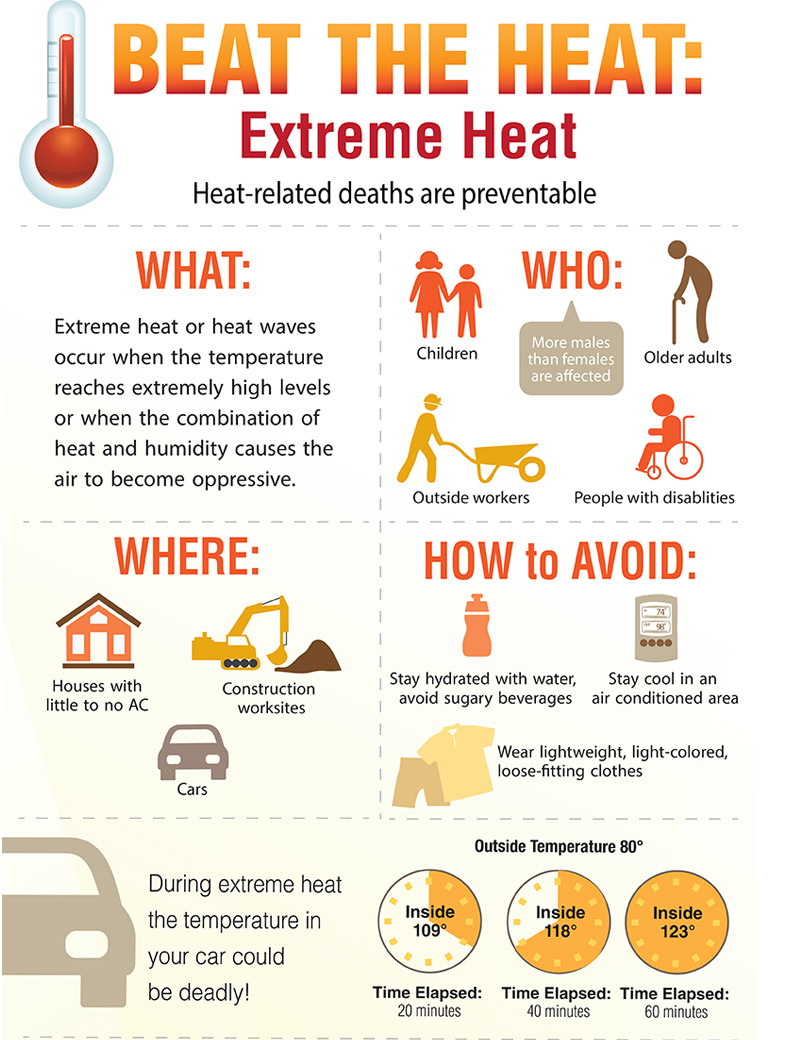
Authorities are reminding the public that extreme heat can be life-threatening, particularly for older adults, young children, and individuals with certain medical conditions. Taking simple precautions can make a significant difference in staying safe during a heat event.
Residents are encouraged to drink plenty of water throughout the day, even if they do not feel thirsty, and to avoid spending extended periods outdoors during the hottest parts of the day. Those who must be outside are advised to wear lightweight, light-colored clothing and take frequent breaks in shaded or air-conditioned areas.
Officials also stress the importance of checking on elderly relatives, neighbors, and others who may be more vulnerable to heat-related illness. If you know someone who does not have access to air conditioning, consider reaching out to see if they need assistance finding a cool place to stay.
Never leave children or pets unattended in parked vehicles, as temperatures inside a car can rise to deadly levels within minutes, even on a moderately warm day.
Anyone experiencing symptoms of heat exhaustion or heat stroke — such as heavy sweating, dizziness, confusion, or loss of consciousness — should seek medical attention immediately.
Sussex County officials are urging residents and visitors to take the upcoming heat wave seriously, as forecasters warn of a dangerous stretch of hot weather set to arrive just in time for the Fourth of July holiday.
Beginning Wednesday, July 1, a punishing heat wave is expected to settle over Sussex County and much of the eastern United States, with temperatures projected to climb above 100 degrees. When humidity is factored in, the heat index could soar as high as 115 degrees — making this the hottest holiday weekend of the summer so far. The National Weather Service has placed the area under an extreme heat watch through Independence Day. While scattered showers and thunderstorms may offer brief moments of relief, the oppressive heat and humidity could stick around into early next week.
To help people cope with the extreme conditions, Sussex County announced Tuesday that a number of air-conditioned facilities will serve as cooling stations from July 1 through July 5. Normally, county buildings including libraries are available during regular business hours throughout the summer as cooling spots, but the long holiday weekend means most public offices will be closed. To fill that gap, the County Administrative Offices building on The Circle in Georgetown will remain open from 8:30 a.m. to 4:30 p.m. Wednesday through Sunday.
Several library branches will also be open on a limited basis during the heat emergency. The Greenwood Library at 100 Mill St. in Greenwood and the Milton Library at 121 Union St. in Milton will both be open from 10 a.m. to 6 p.m. on Wednesday and Thursday, then closed Friday through Sunday. The South Coastal Library at 43 Kent Ave. in Bethany Beach will be open from 10 a.m. to 7 p.m. on Wednesday and Thursday, then closed the rest of the weekend.
The State of Delaware has also announced cooling stations at select state facilities. For more details, call 2-1-1 or check the state’s website.
Sussex County EMS will nearly double its staffing levels during the holiday period. Paramedics will make routine stops at county cooling facilities, as schedules allow, to field any heat-related questions or concerns. Free individual bottles of water will also be available at these locations. Anyone visiting a cooling station is encouraged to bring any needed medications or specialty items.
County officials are advising everyone to limit time outdoors, especially between roughly 1 p.m. and 6 p.m., when temperatures will be at their peak. County Emergency Managers are also strongly encouraging organizers of Fourth of July events to keep a close eye on the forecast and consider rescheduling activities to cooler parts of the day. Anyone who must be outside during the hottest hours should take frequent breaks and drink plenty of water.
Hot Weather Safety Tips:
Wear lightweight, light-colored clothing, since lighter fabrics reflect sunlight rather than absorbing heat. Stay in well-ventilated areas and avoid physically demanding activity during the hottest hours of the day. Drink plenty of water and steer clear of alcoholic beverages.
Know the warning signs of heat-related illness. Heat cramps can cause muscle pain and spasms during heavy exertion — resting somewhere cooler, sipping water, and gently stretching the affected muscle can help. Heat exhaustion and heat stroke are far more serious. Heat exhaustion may cause a pale or flushed face, headache, and nausea. Heat stroke symptoms include a rapidly rising body temperature, loss of consciousness, a rapid or weak pulse, and quick, shallow breathing. Seek medical attention immediately if heat stroke is suspected.
Check in on friends, family, and neighbors — especially the elderly and young children — who may be more vulnerable to extreme heat. Don’t forget pets: give them extra water, provide shade, or bring them inside where it’s cooler.
Conserving Electricity During the Heat Wave:
With temperatures expected to spike, electricity demand will rise sharply. Sussex County Emergency Management is asking all residents and businesses to help prevent power outages by conserving energy wherever possible.
At home, set air conditioners to 80 degrees or use fans as an alternative, and try to limit how often you open the refrigerator or freezer. Turn off water heaters and non-essential appliances and lights. Hold off on running high-energy appliances like washing machines and dryers until after 8 p.m. Opt for light meals that require little cooking — an outdoor grill or microwave uses far less energy than an electric range. Keep blinds, shades, and drapes closed during the hottest part of the day to block out sunlight. Move lamps, televisions, and other heat-generating items away from air conditioner thermostats, since the heat they emit can cause the AC to run longer than needed. Also make sure furniture and other objects aren’t blocking central air conditioning vents, so cool air can flow freely through your home.
Businesses can do their part by raising thermostats slightly and switching off any lighting or equipment that isn’t necessary.
Sussex County is also reminding residents to take advantage of the county’s free Smart911 service by creating a safety profile for their household. These profiles give first responders potentially life-saving details in an emergency, including property information, special medical needs, and family contacts. Visit www.smart911.com to sign up.
Sussex County Emergency Management will continue tracking the situation and will release updates as conditions develop. For the latest information, follow the county’s emergency management pages on Facebook at www.facebook.com/SussexCountyPublicSafety and on X at www.x.com/SussexCtyDE_EM.
Millions of people across the Midwest and Great Lakes states are enduring brutal heat and humidity Tuesday, with no quick end in sight before the oppressive conditions push eastward toward the Atlantic coast.
The National Weather Service pulled no punches in its assessment, describing the situation as “dangerous.” Heat index readings — which factor in both air temperature and moisture in the air — topped 100 degrees Fahrenheit (37.8 degrees Celsius) in several locations. Officials warned that the conditions pose a serious risk for heat-related illness, particularly for those without access to air conditioning.
In Detroit, air temperatures climbed into the high 90s and could potentially hit 100 degrees at some point through Thursday. City officials responded by opening a dozen recreation centers to the public as cooling refuges, with some staying open as late as 11 p.m. Large portions of Michigan, along with Illinois, Ohio, Indiana, Kentucky, and much of Iowa, are under an extreme heat warning.
The heat wave is expected to move into the Northeast next, with cities like New York and Boston set to experience the worst of it around the Fourth of July holiday. In Norristown, Pennsylvania — about 20 miles (32 kilometers) outside Philadelphia — officials have already canceled a Saturday parade due to the anticipated weather.
In Chicago, the History Museum opened its doors free of charge to Illinois residents Tuesday, offering a cool escape from the heat. The extreme temperatures also caused roads in parts of Illinois to buckle and crack, a phenomenon that occurs when pavement has no room to expand in the heat and forces itself upward.
Detroit window washer Stephen Mason, 72, was already on the job at 9:15 a.m., cleaning mayflies off the glass of a local convenience store. He started early to get ahead of the worst of the day’s heat — but even then, temperatures had already reached 85 degrees (29.4 C).
“It’s the only way to beat it. But it’s already starting to cook out here,” Mason said.
Nearby in Detroit’s Indian Village neighborhood, 36-year-old runner Adam Schubatis was pushing through a shortened route of just 6 miles (9.6 kilometers), going shirtless to cope with the heat.
“I know where all the drinking fountains are,” he said. “My wife thought I was crazy. She offered to pick me up if I got tired or if there was anything I was doing that wasn’t safe.”
In Milwaukee, more than 100 firefighters battled a school fire for hours in the sweltering heat. Fire Chief Aaron Lipski said crews were rotating shifts and removing their heavy protective coats to rehydrate throughout the effort.
In Grosse Pointe Park, a suburb of Detroit, 64-year-old George Liller stepped up to help his neighbors. After installing air conditioning in his own home, he posted a spare window unit on Facebook — free to whoever needed it, extension cord and remote control included.
“It was probably on my porch maybe 15 minutes,” Liller said. “That air conditioner was given to me. I thought, ‘Somebody needs it.’ I know how it feels to be in an old house when it’s this hot.”
If you’re planning to celebrate the Fourth of July outdoors this year, be prepared for some dangerously hot conditions. The National Weather Service has put heat warnings and watches in place across large portions of the Midwest and East Coast as the holiday weekend approaches.
Meteorologists warn that temperatures in many of these areas could climb high enough to break existing records. Residents are being urged to take precautions, stay hydrated, and limit time spent outside during peak heat hours.
A photo from Chicago captured residents seeking relief at the fountain in Millennium Park as temperatures climbed above 90 degrees earlier this week, offering a preview of what much of the country may experience heading into the holiday.
The National Weather Service office in Mount Holly, New Jersey has issued an Extreme Heat Watch, effective starting June 30th at 1:31 PM Eastern Time and continuing through July 4th at 8:00 PM Eastern Time.
The watch signals the potential for dangerously high temperatures over the multi-day period, which coincides with the Fourth of July holiday weekend when many people are expected to be outdoors.
Residents are encouraged to stay hydrated, limit time spent outside during the hottest parts of the day, and check on elderly neighbors, young children, and pets who may be especially vulnerable to extreme heat conditions.
Additional details and any updates to this watch can be found through the National Weather Service.
An Extreme Heat Warning has been issued by the National Weather Service office in Mount Holly, New Jersey, covering a multi-day stretch of dangerous heat conditions.
The warning went into effect on June 30th at 1:31 PM Eastern Time and is set to remain in place through July 4th at 8:00 PM Eastern Time — spanning the entire Independence Day holiday weekend.
Health officials and emergency management agencies typically urge residents to drink plenty of water, avoid prolonged time outdoors during peak afternoon hours, and check on elderly neighbors, young children, and pets during extreme heat events.
Cooling centers may be available in your area. Residents are encouraged to contact local officials for information on nearby locations where relief from the heat can be found.
Virginia wildlife officials have released their 2026 deer population report, offering an in-depth look at the 2025-26 hunting season — and the findings carry significance for the entire region, including the Delmarva Peninsula.
From a population management standpoint, deer numbers in Virginia are trending higher than desired. Officials use a deer population index — measuring the number of antlered bucks harvested per square mile of deer habitat in each county — to gauge where populations stand relative to management goals. Based on that index, deer numbers need to come down in 56 out of 97 Virginia counties. Management objectives are currently being met in just 37 of those 97 counties.
On public lands, particularly within the roughly 1.7 million acres of National Forest land in Virginia, deer populations tell a different story than on private land. Data from National Forest areas — especially those west of the Blue Ridge — form the backbone of public land population assessments, as Wildlife Management Areas and other public lands east of the Blue Ridge are generally too small to yield reliable population data.
Looking at the big picture, statewide deer population estimates going back to 2004 show a steady upward climb. Before the 2014 hunting season, the population was estimated at around 1.1 million deer. By 2023 and 2024, that figure had grown to an estimated 1.3 million. Officials use the Downing population reconstruction method — which incorporates harvest data, biological information, and observation surveys — to arrive at these estimates.
At the same time deer numbers are climbing, the number of hunters is heading in the opposite direction. Virginia sold more than 343,000 deer licenses at its peak in 1986. For the 2025-26 season, that number had dropped to just 177,541. License sales have fallen 19 percent over the last decade and 34 percent over the past 25 years. Hunters are aging out of the sport faster than younger generations are picking it up, and youth license numbers are also declining. Licensed deer hunters now make up only about 2 percent of Virginia’s total population. The number of hunters exempt from licensing requirements — once estimated near 39,000 in 2015 — is now thought to be somewhere between 17,000 and 20,000.
Disease Updates
Hemorrhagic Disease (HD) — which includes Epizootic Hemorrhagic Disease and bluetongue virus — was relatively quiet in Virginia last year. Officials confirmed one small outbreak in northern Virginia and received scattered reports of suspected deaths elsewhere that were never confirmed. However, neighboring states weren’t as fortunate. Southeastern Ohio and just across the state line in West Virginia experienced significant HD activity, fueled by severe drought conditions that created ideal breeding grounds for the biting midges that spread the disease. In areas where HD occurs less frequently, the virus tends to be more lethal to infected deer. The good news is that deer populations typically recover within a few years following an outbreak.
On the Chronic Wasting Disease front, officials broke their own record for the most positive detections in a single season, confirming 126 cases despite testing fewer deer than the year before. Sixty of those positives came from Frederick County alone. Officials say none of last year’s detections will trigger the creation of new Disease Management Areas or expand existing ones.
Of particular note for Delmarva residents: CWD has now been confirmed on the Delmarva Peninsula for the first time. Delaware recorded its first and second CWD-positive white-tailed deer in Sussex County, the state’s southernmost county. With Delaware’s detection, South Carolina is now the only remaining southeastern state that has yet to identify a CWD-positive animal.
Wildlife officials say more information on how hunters can help manage Virginia’s deer population will be available next month.
Justin Folks serves as the Deer Project Leader for the Department of Wildlife Resources.
New Castle County Division of Police detectives have arrested two juveniles following an investigation into an attempted robbery that also involved an assault on a victim in Newark, Delaware.
The incident was first reported on Friday, May 22, 2026, at around 6:27 p.m., when officers were dispatched to the Iron Hill Apartments, situated in the unit block of Brookedge Court, in the 19702 zip code area of Newark.
Upon arrival, officers learned that a victim had been assaulted during what appeared to be an attempted robbery. Given the nature of the circumstances involved, detectives took over the investigation, which ultimately led to the identification and arrest of two juvenile suspects.
A flagging operation is currently underway on Stockton Drive between South Stockton Drive and East Basin Road, and drivers in the area should be prepared for possible slowdowns.
The operation is described as intermittent, meaning traffic control personnel may be directing vehicles through the area at various intervals rather than continuously. The flagging activity is expected to remain in place until 1 p.m.
Drivers are encouraged to allow extra travel time or consider alternate routes if possible until the work is completed.
Delaware students are being set up for success in some of today’s most in-demand careers, thanks to a program that bridges traditional classroom instruction with practical, hands-on experience.
Through Career and Technical Education, students across the state are tackling real problems, developing solutions, and putting technical knowledge to work in real-world situations — skills that employers and Delaware’s broader economy will increasingly rely on in the coming years.
That dedication to preparing the next generation of workers recently paid off in a big way, as Delaware’s Career and Technical Education efforts earned national recognition — a milestone that underscores the impact these programs are having on students and the state alike.
Delaware is making strides in preparing young people for careers in the healthcare field, and the results are now drawing attention on a national stage.
Students from across the state earned national recognition at the 2026 HOSA competition, a milestone that underscores the value of connecting what students learn in the classroom to real-world healthcare settings.
State officials and educators have emphasized that when students are given the chance to put their knowledge into practice, develop hands-on technical skills, and explore potential career paths, they are far better equipped for life after graduation.
The national recognition received at the 2026 HOSA event is being seen as a reflection of that preparation paying off, with Delaware’s student competitors standing out among peers from across the country.
Delaware is working to secure the future of its teaching workforce by encouraging students to explore education careers before they even graduate.
Through programs such as Teacher Academy and Educators Rising, students are getting real classroom experience and building the leadership skills they will need if they choose to pursue careers in education.
State officials say the strategy is designed to help meet Delaware’s growing demand for qualified educators in the years ahead.
The programs give young people a head start by immersing them in the teaching profession early, allowing them to make informed decisions about whether education is the right career path for them.
Delaware officials recently highlighted the initiative as a key part of the state’s broader workforce development efforts, showcasing how early exposure to the classroom can help pipeline future teachers into the profession.
Delaware Attorney General Kathy Jennings is declaring a major legal win after the United States Supreme Court ruled in favor of her and a group of fellow attorneys general in a battle against the Trump Administration over birthright citizenship.
Jennings released a statement responding to the high court’s decision, describing the fight as one that began almost immediately after President Trump returned to the White House.
“When President Trump took office in 2025, he immediately issued a flood of flagrantly unconstitutional and illegal executive orders,” Jennings said. “In a matter of days, I and my fellow Attorneys General began filing lawsuits to stop him. We have [continued that fight.]”
The attorney general framed the Supreme Court’s ruling as a vindication of those early legal efforts, which she said were aimed at blocking executive actions she believed crossed constitutional boundaries.
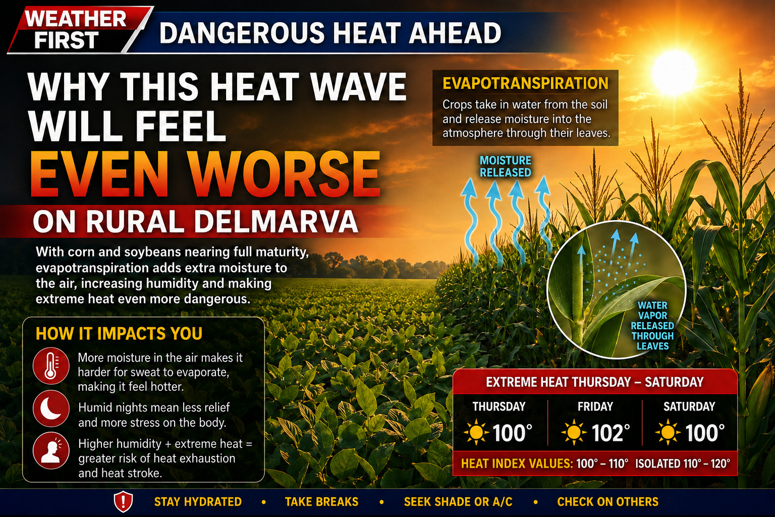
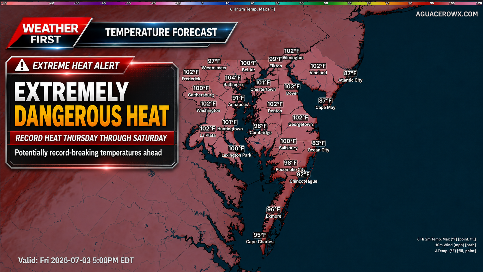
An already dangerous and potentially record-breaking heat wave is expected to become even more impactful later this week across Delmarva, especially in rural agricultural areas where crops are nearing peak maturity.
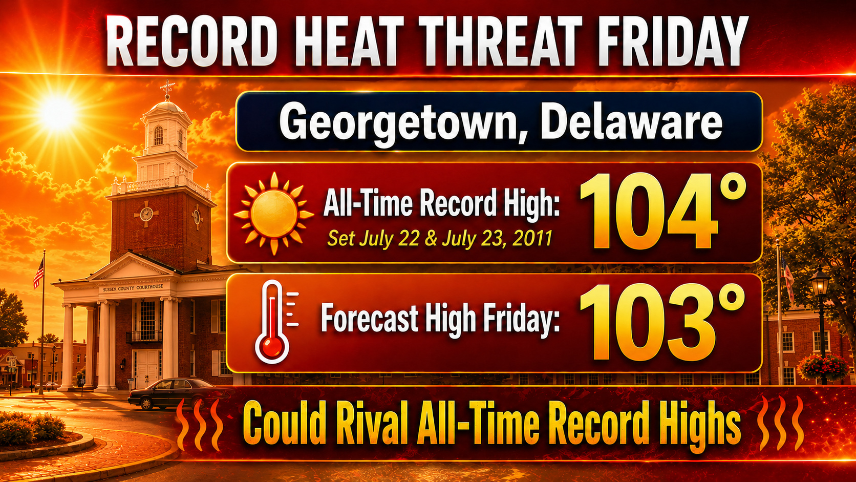
Temperatures are forecast to climb into the upper 90s and lower 100s Thursday through Saturday, with heat index values potentially reaching dangerous levels. While the air temperature alone will be hazardous, the humidity could make conditions feel even worse, and part of that local moisture may come directly from the fields.
Across Delmarva, corn and soybean fields are now approaching the point in the growing season where evapotranspiration becomes a major factor. Evapotranspiration is the process where moisture moves from the soil and plants into the atmosphere. In simple terms, crops take in water through their roots and release moisture through their leaves. When large areas of corn and soybeans are actively growing, they can add a noticeable amount of water vapor to the lower atmosphere.
This is sometimes called “corn sweat,” and while the term is often used in the Midwest, the same process can happen across Delmarva’s agricultural landscape.
During a major heat wave, that extra moisture can make a big difference. Higher humidity makes it harder for sweat to evaporate off the skin, which is the body’s natural way of cooling itself. As a result, the same air temperature can feel much hotter and become more dangerous for people working or spending time outside.
The impact may be especially noticeable in rural parts of Delaware and Maryland’s Eastern Shore, where large fields of corn and soybeans surround many communities. These areas can hold onto low-level moisture, especially during the morning, evening and overnight hours. That can keep dew points elevated and prevent temperatures from cooling efficiently at night.
This is one reason heat waves can become especially dangerous when they last several days. Even if afternoon dew points mix down somewhat due to west or northwest winds, the combination of intense sunshine, hot ground, maturing crops and lingering low-level moisture can keep heat stress elevated. Nights may also remain uncomfortably warm and muggy, giving the body less time to recover before the next day’s heat builds again.
The hottest stretch is expected Thursday through Saturday, when temperatures may reach 100 degrees or higher in parts of the region. Heat index values could climb into the 100 to 110 degree range at times, creating a serious risk for heat exhaustion and heat stroke.
Outdoor workers, farmers, construction crews, athletes, older adults, young children and those without reliable air conditioning will be most at risk. The agricultural influence on humidity means rural areas may not get much relief, even away from the larger towns and cities.
This heat wave should be taken seriously. Limit outdoor work during the hottest part of the day, take frequent breaks in shade or air conditioning, drink plenty of water and check on neighbors, family members and pets. Those working in fields or around farms should be especially cautious, as the combination of direct sun, high humidity and limited shade can become dangerous very quickly.
While crop evapotranspiration is a natural part of the growing season, it can amplify the human impact of extreme heat. Later this week, Delmarva will not only be dealing with record-challenging temperatures, but also a rural humidity boost from maturing crops that may make the heat feel even more oppressive.
Despite the heat, the New Castle County Division of Police is heading to the LaGrange Neighborhood with a Pop-Up Play Zone event designed to bring the community together.
Families and children are encouraged to come out and enjoy an afternoon packed with games, snacks, and the chance to meet and connect with local neighbors and officers.
The event is seen as a great way for kids to get outside and for residents to build relationships within their community.
With an extremely dangerous stretch of heat expected later this week, residents across Delaware, Maryland and the broader Mid-Atlantic should begin preparing now. Temperatures are forecast to climb into the upper 90s and lower 100s, with heat index values potentially reaching the 100 to 110 degree range at times. This type of heat can become dangerous quickly, especially when it lasts for several days in a row.
Extreme heat is one of the most serious weather hazards during the summer months. The Maryland Department of Health warns that exposure to extreme heat can lead to heat cramps, heat exhaustion, heat stroke and even death. The risk is highest for older adults, young children, people with chronic health conditions, outdoor workers, athletes, pets and anyone without reliable access to air conditioning.
The best way to stay safe is to limit outdoor activity during the hottest part of the day, usually from late morning through early evening. Drink plenty of water, even if you do not feel thirsty, and avoid alcohol or too much caffeine, which can increase dehydration risk. Wear lightweight, loose-fitting and light-colored clothing, and take frequent breaks in shade or air conditioning. The CDC recommends staying in air-conditioned spaces as much as possible, taking cool showers or baths, checking on neighbors and never leaving children or pets in vehicles.
For those who do not have air conditioning or need a safe place to cool down, cooling centers are available in parts of Delaware and Maryland.
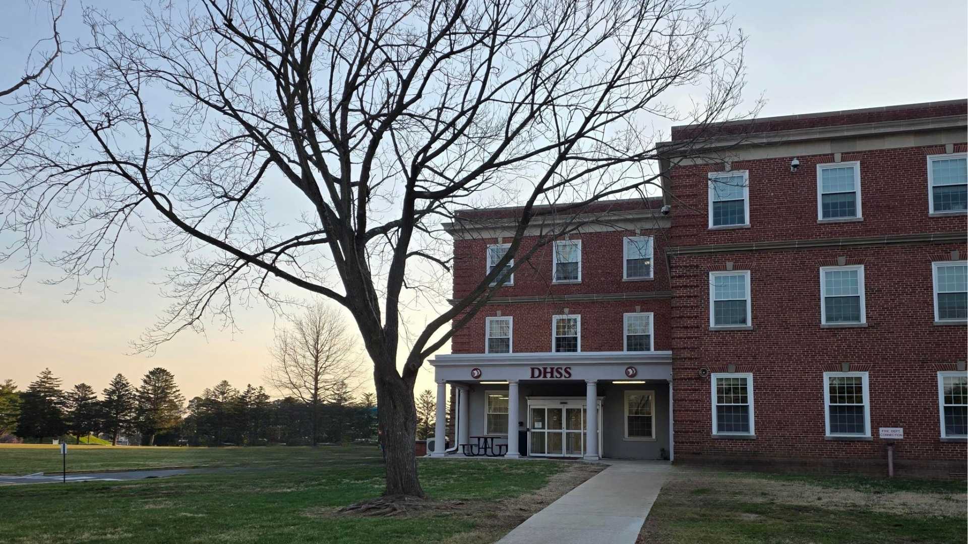
In Delaware, the Department of Health and Social Services has announced cooling centers at state service centers during this stretch of heat. As of the latest state announcement, DHSS facilities are open as cooling centers from June 30 through July 2 from 8:30 a.m. to 4:30 p.m. These locations provide air-conditioned spaces where residents can cool down and stay hydrated.
Delaware cooling locations include the Claymont State Service Center, DHSS Canby Park Office in Wilmington, Churchman’s Corporate Center in New Castle and Hudson State Service Center in Newark for New Castle County. In Kent County, locations include the Smyrna State Service Center and Williams State Service Center in Dover. In Sussex County, cooling locations include Adams State Service Center in Georgetown, Laurel State Service Center and Shipley State Service Center in Seaford. Hudson, Williams and Adams State Service Centers are also listed as being open until 6 p.m. on Wednesday, July 1. Residents should check Delaware DHSS or Delaware.gov for any updated hours later in the week.
In Maryland, cooling center information is handled by local counties and cities. The Maryland Department of Health maintains a county-by-county cooling center contact list with phone numbers, websites and local emergency management contacts. Eastern Shore residents can check with their county health department, local emergency management office or public library system for the closest open cooling location.
For Maryland’s Eastern Shore, Caroline County lists library branches in Denton, Federalsburg and Greensboro as shelter locations during extreme heat. Dorchester County says cooling centers will be open at the Cambridge and Hurlock branches of the Dorchester County Public Library during extreme heat events. Kent County, Queen Anne’s County, Somerset County, Wicomico County and Worcester County all have health department or emergency management contacts listed through the Maryland Department of Health cooling center contact page.
It is also important to know the warning signs of heat illness. Heat exhaustion can include heavy sweating, weakness, dizziness, nausea, headache, muscle cramps and a fast pulse. Move the person to a cooler location, loosen clothing, apply cool cloths and give sips of water. Heat stroke is a medical emergency. Warning signs can include confusion, passing out, very high body temperature, hot skin or a rapid pulse. Call 911 immediately if heat stroke is suspected.
This upcoming heat wave will be especially concerning because it may last several days and coincide with outdoor holiday events. Check on family members, elderly neighbors and anyone who may not have air conditioning. Bring pets indoors, limit pavement walks during peak heat and make sure animals have access to shade and fresh water.
The main message is simple: take the heat seriously. Plan outdoor work or errands for the morning, spend the hottest hours inside, use cooling centers when needed and stay updated on any warnings or local cooling station announcements through state and county officials.
ANNAPOLIS, Maryland — The Maryland Department of Agriculture (MDA) is calling on those involved in the state’s seafood industry to make their voices heard at a series of upcoming public meetings.
Harvesters, processors, restaurant owners, distributors, and other stakeholders connected to Maryland’s seafood trade are all encouraged to attend and share their thoughts on what’s working — and what isn’t — when it comes to promoting and marketing the state’s seafood products.
The MDA is organizing these sessions in collaboration with the Maryland Department of Natural Resources. Officials say the meetings are designed to capture a wide range of perspectives from across the industry on both the hurdles and the possibilities tied to seafood marketing in Maryland.
Further details on meeting dates, times, and locations were expected to be released through official MDA channels.
Seventeen downtown organizations across the First State are now holding national designations after the Delaware on Main Street Program presented them with certificates of recognition.
The Delaware on Main Street Program, which operates within the Delaware Division of Small Business, awarded the certificates of accreditation or affiliation to the 17 community organizations on behalf of Main Street America.
A potentially historic heat wave is set to build across the Northeast and Mid-Atlantic beginning Wednesday and lasting into the holiday weekend, with dangerous heat and humidity creating a significant risk for heat-related illness.
Strong high pressure in the mid-levels of the atmosphere is developing across the Mississippi Valley, Great Lakes and Ohio Valley early this week. That ridge will expand eastward into the Mid-Atlantic by Wednesday and remain in place through at least Saturday. This setup will allow temperatures to surge well above normal, with some locations potentially challenging all-time record highs Thursday and Friday.
High temperatures are expected to climb into the mid and upper 90s on Wednesday before reaching the 100 to 105 degree range Thursday and Friday. Heat index values will likely range from 100 to 110 degrees Wednesday, then increase greater than 110 degrees by Thursday and Friday.
The most intense heat is expected Thursday and Friday as winds shift more west to northwest. That flow will allow for better mixing of the lower atmosphere, lowering dew points somewhat during the afternoon but also helping temperatures climb even higher. Downsloping winds off the Appalachians may add additional warming, making this the type of pattern capable of producing record-breaking heat across the region.
The National Weather Service has upgraded the Extreme Heat Watch to an Extreme Heat Warning for southeastern Pennsylvania, northern Delaware and portions of New Jersey from Wednesday afternoon through Saturday. This includes areas where confidence is highest that heat index values will reach dangerous levels over multiple days.
For far southern New Jersey, the New Jersey barrier islands and Delmarva, an Extreme Heat Watch remains in effect from Thursday afternoon through Saturday. Heat index values may approach 100 degrees on Wednesday, but the more dangerous heat is expected to arrive Thursday and continue into Saturday.
While temperatures may ease slightly by Saturday, the heat will still be dangerous. Highs are forecast to remain in the mid 90s to near 100 degrees, with heat index values around 100 to 110 degrees. Even if some locations fall short of warning criteria by Saturday, the cumulative impact of several days of extreme heat will increase the risk for heat exhaustion and heat stroke, especially with outdoor holiday events and travel underway.
Some relief is expected by Sunday and Monday as the ridge begins to weaken and retreat southwest. However, highs may still remain in the low to mid 90s, with heat index values in the mid 90s to low 100s. The pattern change may also bring increasing chances for showers and thunderstorms during the holiday weekend.
This will be a high-impact heat event. Limit time outdoors during the afternoon and early evening, drink plenty of water, check on vulnerable neighbors and relatives, and never leave children or pets inside vehicles. Outdoor workers and anyone attending holiday events should take frequent breaks in shade or air conditioning.
Ocean City, Maryland is welcoming summer with an action-packed July schedule, centered around the nation’s 250th birthday and a spirit of community celebration.
The coastal resort town announced its July calendar on June 30, 2026, highlighting a landmark Independence Day event on July 4th as the centerpiece of the month’s festivities.
The celebration is designed to honor the United States’ 250th anniversary while also spotlighting the best that Ocean City has to offer — bringing together locals and visitors in a star-spangled tribute to the country’s milestone birthday.
Organizers are encouraging everyone to come out, enjoy the summer sunshine, and be part of what promises to be a memorable month along the Maryland shore.
The Worcester County Board of Electrical Examiners has announced that its upcoming meeting, originally scheduled for July 14, 2026, will not take place.
The session had been planned for 3:00 p.m. at the Worcester County Government Center, Meeting Room 1102, located at 1 West Market Street in Snow Hill, Maryland.
An agenda for the July 14 date had been made available through the county. Residents seeking additional information can visit the Worcester County events calendar online.
A horse named C Millertimeagain picked up his sixth career win Monday evening at Harrington Raceway, taking the top spot in one of three Delaware Standardbred Breeders’ Fund (DSBF) divisions for 3-year-old male pacers.
The race, worth $20,000, was completed in a time of 1:51.4, with driver Corey Callahan guiding the gelding to victory. C Millertimeagain returned $2.10 to win bettors.
The horse is owned by Ervin Miller, James Frawley, and James Knowlton. C Millertimeagain is a gelding by Roddy’s Bags Again.
The race took place on Monday, June 29, as part of the ongoing DSBF stakes series at Harrington Raceway in Delaware.
As Delaware gets ready to mark a truly historic occasion — the 250th anniversary of American independence — the Delaware State Fire Marshal’s Office is sending a clear message to both residents and visitors: when it comes to fireworks, leave it to the experts.
The upcoming Semiquincentennial celebration is expected to bring record-breaking crowds to community events throughout the state. With that in mind, fire officials say they are closely monitoring what they describe as an elevated risk of preventable fire-related injuries and incidents tied to the holiday festivities.
The Delaware State Fire Marshal’s Office is encouraging everyone taking part in the Fourth of July celebrations to attend professionally organized fireworks displays rather than attempting to handle fireworks on their own.
A left lane closure is in effect on W Market Street eastbound between S Mary Street and S James Street due to ongoing construction activity.
The closure is expected to remain in place until 4:30 PM. Drivers traveling through that stretch should anticipate possible delays and consider using alternate routes to avoid the affected area.
Motorists traveling southbound on Pennsylvania Avenue should plan for a lane restriction currently in place due to construction activity.
The right lane is closed along the southbound stretch of Pennsylvania Avenue between North Union Street and North Clayton Street. The closure is expected to remain in effect until 5 p.m.
Drivers in the area are encouraged to allow extra travel time or consider alternate routes to avoid potential delays.
Drivers traveling along Dinahs Corner Road should be prepared for intermittent lane closures currently in effect between Pearson Corner Road and West Denny Road.
The lane restrictions are due to construction activity in the area. The closures are expected to remain in place until 6:00 PM.
Motorists are encouraged to allow extra travel time or consider using an alternate route to avoid potential delays in the area.
Drivers traveling along Harvest Drive between Wagon Wheel Drive and Wheatsheaf Drive should be prepared for intermittent lane closures as construction crews work in the area.
The lane restrictions are expected to remain in place until 5 PM. Motorists are encouraged to use caution when passing through the construction zone and to allow additional time for their commute.
Northbound travelers on US-301 are facing a lane restriction near the merge with DE-1 due to ongoing construction activity.
The left lane is currently closed at that location, creating potential slowdowns for drivers in the area. The closure is expected to remain in effect until 5 p.m.
Drivers are encouraged to allow extra travel time or consider alternate routes to avoid delays in the construction zone.
Drivers traveling along Nassau Road should be aware of an intermittent lane shift currently in effect between Coastal Highway (Route 1) and New Road.
The lane shift is expected to remain in place until 5 p.m. Motorists are urged to slow down and proceed with caution through the affected stretch of roadway.
No additional details regarding the cause of the lane shift were provided. Drivers are encouraged to allow extra time when traveling through the area and to watch for any traffic control personnel or signage.
Drivers traveling along West Harvest Drive should be prepared for slowdowns due to ongoing construction activity in the area.
Intermittent lane closures are in effect on West Harvest Drive from Wagon Wheel Drive to Wheatsheaf Drive. The closures are expected to remain in place until 5 PM.
Motorists are encouraged to use caution when passing through the construction zone and to allow additional time for their commute if traveling in that area.
An intermittent lane closure is currently in effect at the intersection of Haystack Lane and Wheatsheaf Drive as a result of construction work in the area.
The lane restriction is expected to continue until 5 PM. Drivers traveling through that area should anticipate possible delays and consider alternate routes if available.
Motorists are encouraged to slow down and use caution when passing through the construction zone.
Drivers heading through the intersection of Centerville Road and Boxwood Road should be aware of a temporary lane restriction currently in effect.
The right turn lane at Boxwood Road is closed while crews perform signal service work at the intersection. Motorists are advised to allow extra travel time or consider alternate routes until the work is completed.
The closure is expected to remain in place until 8 a.m. No further details on the nature of the signal work were provided.
Good morning, Delmarva! We’re wrapping up June with a scorcher of a day. Expect mostly sunny skies and a high near 90°F this afternoon, with light south winds keeping things relatively calm at 0 to 10 mph. Make sure you’re staying hydrated and limiting time outdoors during peak afternoon heat if you can.
Tonight brings some relief as temperatures drop to a more comfortable 69°F under mostly clear skies — a pleasant night to open those windows!
Looking ahead to Wednesday, hold onto your hats because we’re cranking it up even further. A full sunny day will push temperatures close to 95°F, which could feel even hotter with humidity factored in. Heat safety will be critical — please check on elderly neighbors and keep pets indoors. Wednesday night stays warm, only cooling to around 76°F under mostly clear skies.
Bottom line: it’s a hot start to July Fourth week, Delmarva! Stay cool, stay safe, and keep it right here on TV Delmarva for your latest updates. See you tonight!
An Extreme Heat Warning has been issued by the National Weather Service out of Mount Holly, New Jersey, starting at 2:44 AM on June 30th and remaining in effect until 8:00 PM on July 4th.
The multi-day warning covers the heart of the Independence Day holiday weekend, raising concerns about dangerous heat conditions for anyone spending time outdoors for Fourth of July celebrations.
Residents are strongly encouraged to stay hydrated, limit outdoor activity during peak afternoon hours, and check on elderly neighbors, young children, and pets during this extended period of extreme heat.
The warning was issued well in advance to give communities time to prepare. Local cooling centers may be available for those without access to air conditioning — residents should contact local authorities for information on nearby resources.
The National Weather Service out of Mount Holly, New Jersey has put an Extreme Heat Watch into effect, warning residents of potentially dangerous heat conditions expected over the coming days.
The watch went into effect on June 30th at 2:44 AM Eastern Time and is set to remain active through July 4th at 8:00 PM Eastern Time — covering much of the Independence Day holiday weekend.
An Extreme Heat Watch means that conditions are favorable for a dangerous heat event to develop. Residents are urged to stay hydrated, limit time outdoors during peak afternoon hours, and check on elderly neighbors, young children, and pets.
Officials typically recommend finding air-conditioned spaces during extreme heat events, especially for those without cooling at home. Local cooling centers may be available in the area — residents should contact their local government for information on nearby resources.
NEW CASTLE — Delaware residents facing another dangerous stretch of high temperatures will have somewhere to turn for relief, as state health officials are opening cooling centers across the area.
The Delaware Department of Health and Social Services announced that its facilities will serve as cooling centers from June 30 through July 2, giving residents a safe place to escape the heat as extreme temperatures and dangerous heat index values are expected to continue.
Officials are urging anyone who needs relief from the heat to take advantage of these available locations during the specified dates and hours.
Drivers heading through the intersection of DE-26 and Kent Avenue should be aware that the traffic signal at that location is currently operating in flash mode.
According to Delaware Department of Transportation, the flashing signal is the result of construction activity in the area. The signal is expected to remain in flash mode until 5 a.m.
When a traffic signal is flashing, drivers should treat the intersection with extra caution. A flashing red light requires a full stop before proceeding, similar to a stop sign, while a flashing yellow light calls for drivers to slow down and proceed carefully.
Motorists in the area are encouraged to allow extra travel time and remain alert while passing through the construction zone.
Southbound travelers on Interstate 95 near the Chapman Road underpass should expect delays overnight as two right lanes have been closed in the area.
The lane closures are expected to remain in effect until 5 AM. Drivers are advised to allow extra travel time and proceed with caution through the affected stretch of highway.
No additional details regarding the cause of the closure were immediately available. Motorists are encouraged to stay alert for traffic control personnel and signage in the area.
Motorists traveling along US-13 between the US-40 junction and Llangollen Boulevard are facing a right lane closure that is expected to remain in place until 6 AM.
Drivers in the area are advised to use caution and allow for additional travel time while the lane restriction is active. No further details about the cause of the closure were immediately available.
Stay with TV Delmarva for updates on this and other traffic conditions across the region.
A westbound lane on DE-2 between Trout Stream Drive and Cleveland Avenue is closed, according to Delaware transportation officials.
The closure is expected to remain in effect until 6 AM. Motorists traveling in that area are advised to use caution and allow extra time for their commute.
No additional details regarding the cause of the closure were provided. Drivers are encouraged to check for updates before heading out.
Eastbound travelers on US-40 are facing a lane restriction between Salem Church Road and Rockwood Road, with the right lane closed until 6 AM.
DelDOT has reported the closure, and drivers in the area should anticipate potential slowdowns during this time. No additional details regarding the cause of the closure have been provided.
Motorists are encouraged to allow extra travel time or consider using an alternate route until the lane reopens.
Travelers on DE-16 between DE-113 and DE-1 should be aware of intermittent shoulder closures currently in place due to construction work in the area.
The closures are expected to continue until 6 a.m., and drivers are encouraged to remain alert and allow extra time when passing through the affected stretch of roadway.
No additional details regarding the nature of the construction were provided. Motorists should watch for construction crews and equipment near the shoulder and follow any posted signage or traffic control instructions.
Travelers heading southbound on Route 1 near the Route 9 intersection are facing lane restrictions following a crash at that location.
According to traffic officials, two right lanes on Route 1 southbound at Route 9 have been closed as a result of the incident. Motorists in the area are advised to use caution and allow for extra travel time.
Drivers are encouraged to consider alternate routes until the lanes are reopened and normal traffic flow is restored.
Northbound travelers on Valley Road between Limestone Road and Grove View Drive are facing intermittent lane closures that are expected to remain in place until 6 a.m.
Drivers in the area should use caution and allow extra travel time. Alternate routes are recommended where possible until the closures are lifted.
Travelers on DE-2 are facing overnight lane closures between East Green Valley Circle and Meadowood Drive, according to a traffic alert.
Both the eastbound and westbound left lanes on that stretch of roadway are currently closed. The restrictions are expected to remain in place until 6 a.m.
Drivers in the area should allow extra travel time or consider using alternate routes until the lanes reopen.
Travelers heading along Star Road between Alton Wood Lane and Cox Road are facing intermittent lane closures due to ongoing construction activity.
The lane restrictions are expected to remain in place until 6 p.m., according to traffic officials. Drivers in the area should anticipate possible delays and consider alternate routes if available.
Motorists are urged to slow down, remain alert, and follow the directions of any traffic control devices or personnel present in the construction zone.
Motorists traveling eastbound on Pennsylvania Avenue should be aware of an active lane closure currently in effect between North Union Street and North Clayton Street.
The right lane in the eastbound direction has been shut down to accommodate construction work in the area. Drivers are advised to plan accordingly and allow extra time when traveling through this stretch of road.
The lane is expected to reopen by 6 p.m. Until then, travelers may want to consider alternate routes to avoid potential delays.
Investigators are shining a new light on a decades-old homicide from Wilmington, Delaware, as authorities revisit the 1996 death of 38-year-old Debra Minor.
According to records from the New Castle County Division of Police, the incident occurred in the early morning hours of June 29, 1996 — at around 1:30 a.m. Officers from the New Castle County Division of Police, along with investigators from the State Fire Marshal’s Office, were called to 102 East 40th Street in the Pennrose community of Wilmington.
Debra Minor was 38 years old at the time of her death. Her case has gone unsolved for nearly 30 years.
Authorities have not released additional details about the circumstances surrounding her death at this time. Anyone with information related to this cold case is encouraged to come forward and contact investigators.
A moving operation is currently active near the intersection of Coastal Highway, also known as Route 1, and Broadkill Road, or Route 16, according to traffic officials.
The operation is expected to remain in the area until 3:00 PM. Motorists traveling through that stretch should be prepared for possible slowdowns or lane restrictions while the work is underway.
Drivers are encouraged to allow extra travel time or consider using an alternate route to avoid any delays associated with the moving activity.
A traffic crash has resulted in the right lane being closed at Meadowood Drive at Mayflower Drive, according to transportation officials.
Motorists traveling through the area are advised to use caution and allow extra travel time. Drivers may want to consider alternate routes until the scene is cleared and the lane is reopened.
No additional details regarding the crash or an estimated time for the lane to reopen were immediately available.
Bi-State Boulevard is closed between Bacons Road and Dorothy Road following a report of wires down in the area.
Motorists are urged to avoid the affected stretch of roadway and plan for alternate routes until further notice. No estimated time for reopening has been announced at this time.
Drivers should use caution in the surrounding area and stay alert for updates as crews work to address the situation.
Drivers heading through the Elderon Drive area at The Loop should be prepared for intermittent lane closures as construction work continues in the area.
According to traffic officials, the lane restrictions are expected to remain in place until 6:00 PM. The closures are intermittent, meaning traffic may be able to move through at times, but delays are still possible.
Motorists are encouraged to use caution when passing through the construction zone and to allow additional time for their commute if traveling in that area before the closures are lifted this evening.
An Extreme Heat Watch has been issued by the National Weather Service office in Mount Holly, New Jersey, warning residents of potentially dangerous heat conditions heading into the July 4th holiday weekend.
The watch went into effect at 5:17 PM EDT on June 29th and is set to remain in place until 8:00 PM EDT on July 4th, covering a significant stretch of the Independence Day holiday period.
Residents are urged to take the threat seriously and take steps to stay cool and hydrated during this extended period of extreme heat. Check on elderly neighbors, family members, and those without access to air conditioning, as they are among the most vulnerable during heat events.
Stay tuned to TV Delmarva for the latest updates on this developing weather situation as the holiday weekend approaches.
The National Weather Service office in Mount Holly, New Jersey has issued an Extreme Heat Watch for the area, effective starting June 29th at 5:17 PM Eastern Time and running through July 4th at 8:00 PM Eastern Time.
An Extreme Heat Watch means that conditions are favorable for a dangerous heat event to develop in the coming days. Residents are urged to take the threat seriously, as extreme heat is one of the leading weather-related causes of illness and death.
Health officials typically recommend that people stay indoors during the hottest parts of the day, drink plenty of water even if not feeling thirsty, and never leave children or pets inside parked vehicles. Those without air conditioning are encouraged to visit cooling centers in their area.
Special attention should be given to elderly residents, young children, and those with chronic health conditions, as these groups are most vulnerable to heat-related illness. Neighbors are encouraged to check in on one another during the watch period.
The watch covers the Fourth of July holiday weekend, when many people are expected to be outdoors for celebrations. Residents planning outdoor activities should schedule them for early morning or evening hours when temperatures are lower, and take frequent breaks in the shade or air conditioning.
A traffic crash has prompted the closure of Boulden Boulevard between Southgate Boulevard and Moores Lane, according to transportation officials.
Motorists traveling through the affected stretch are advised to find alternate routes until the roadway is cleared and reopened. No additional details regarding the severity of the crash or an estimated reopening time were immediately available.
Drivers are urged to use caution in the surrounding area and allow extra travel time.
Motorists traveling through Odessa in New Castle County should be aware of a lengthy road closure coming soon to the area.
The Delaware Department of Transportation (DelDOT) has announced that Taylor’s Bridge Road will be completely shut down between Union Church Road and Fleming Landing Road. The closure takes effect Monday, August 3rd and will remain in place 24 hours a day, seven days a week.
The shutdown is expected to last a total of 709 days — nearly two full years — while crews work to replace Taylor Bridge, also identified as Bridge 1-447, in Odessa.
Drivers are encouraged to seek alternate routes during the extended closure period.
Motorists in the area should be prepared for intermittent lane closures on Vance Neck Road between Bayview Road and Marathon Drive.
The lane restrictions are the result of ongoing construction activity in that stretch of roadway. Drivers are advised to plan accordingly and allow extra travel time until the closures are lifted at 5 p.m.
Travelers may want to consider alternate routes to avoid potential delays during this period.
Delaware State Police are currently investigating a shooting that took place Saturday evening in the Newark area.
Around 6:30 p.m. on June 27, 2026, troopers were called to a local hospital after two individuals showed up with gunshot wounds. Both victims were reported to be in stable condition with injuries not considered life-threatening. The Criminal Investigations Unit was brought in to take charge of the case.
As the investigation progressed, detectives determined the shooting likely happened on Otts Chapel Road near Elkton Road in Newark. Officers canvassed the scene and recovered multiple spent shell casings from the area.
The investigation remains active and ongoing. Detectives are urging anyone who may have witnessed the incident or has any relevant information to reach out to Detective J. Lucyk directly at (302) 365-8446. Tips can also be submitted through a private Facebook message to the Delaware State Police or by contacting Delaware Crime Stoppers at 1-800-847-3333.
Anyone who has been a victim or witness of a crime, or who has lost a loved one to a sudden death and needs support, can contact the Delaware State Police Victim Services Unit and Delaware Victim Center. The unit is available around the clock through a toll-free hotline at 1-800-VICTIM-1 (1-800-842-8461). You may also reach the Victim Services Unit by email at [email protected].
Governor Matt Meyer is asking Delaware’s utility watchdog agency to halt a proposed rate increase from Delmarva Power while regulators take a closer look at the request.
In a letter addressed to the Delaware Public Service Commission, Meyer urged the body to exercise its authority under state law — specifically 26 Del. C. § 310 — to freeze Delmarva Power’s distribution rates at their current level during the review process.
The governor’s request comes as the utility has submitted a new application seeking higher rates from customers. Meyer is asking the Commission to prevent any rate changes from taking effect until a full review is completed.
Two major organizations are joining forces to improve the heart health of Delaware residents living in public housing communities across Kent and Sussex counties.
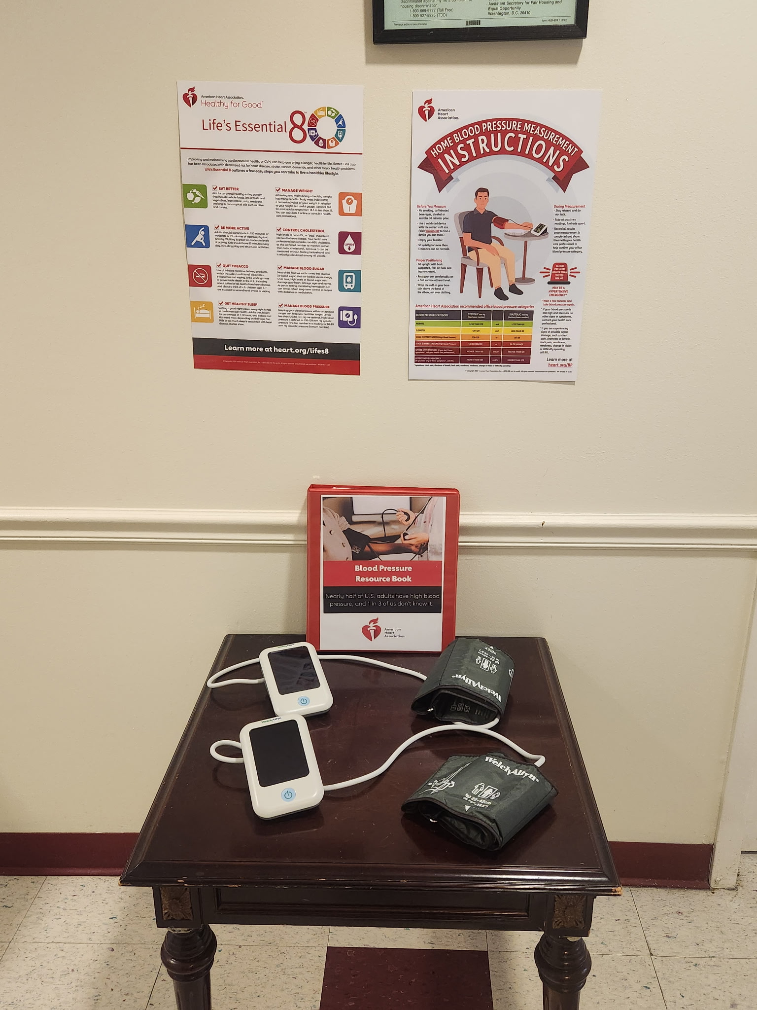
The Delaware State Housing Authority (DSHA) and the Delaware chapter of the American Heart Association (AHA) have announced a new partnership focused on reducing the risk of stroke, hypertension, and heart disease among people living in DSHA-managed public housing.
As part of the effort, residents will receive tools that allow them to monitor their own blood pressure at home, along with educational materials designed to help them better understand and manage their cardiovascular health.
The announcement was made on June 29, 2026, and represents a collaborative push to bring health resources directly into the communities where residents live.
An Extreme Heat Watch has been issued by the National Weather Service office in Mount Holly, New Jersey, set to take effect on June 29th at 2:10 PM Eastern Time and running through July 4th at 8:00 PM Eastern Time.
The watch covers an extended stretch of the upcoming holiday weekend, raising concerns about dangerous heat conditions for residents across the area.
An Extreme Heat Watch means that conditions are favorable for a dangerous heat event in the coming days. Residents are encouraged to stay hydrated, limit outdoor activity during the hottest parts of the day, and seek air-conditioned spaces when possible.
Those most at risk during extreme heat events include the elderly, young children, outdoor workers, and individuals with certain medical conditions. Neighbors are urged to check on one another, particularly those who may be living alone or without access to air conditioning.
Stay with TV Delmarva for continuing updates on this developing weather situation as the July 4th holiday approaches.
An Extreme Heat Watch has been issued by the National Weather Service office in Mount Holly, New Jersey, set to remain in effect from the afternoon of June 29th through the evening of July 4th.
The watch period begins at 2:10 PM Eastern Time on June 29th and extends through 8:00 PM Eastern Time on Independence Day, covering what could be a dangerously hot holiday weekend.
Residents are encouraged to stay hydrated, limit time outdoors during peak afternoon hours, and check on elderly neighbors, young children, and pets. Extreme heat is one of the leading weather-related causes of illness and death, particularly for vulnerable populations.
More details and updates are expected as the event approaches. Stay with TV Delmarva for the latest on this developing weather situation.
DES MOINES, Iowa — A powerful heat wave that has been baking the Midwest since the start of the week is on the move, and the Eastern United States — including the Mid-Atlantic region — is next in line. Outdoor events have been scrapped or pushed back, cooling centers have been activated, and health officials are warning people to take the heat seriously.
“Overall, we’re looking at just a really hot and humid pattern. It’s going to be with us through most of the week,” said Andrew Ansorge, a meteorologist based in Des Moines, Iowa, describing what he called the first prolonged stretch of heat this summer.
Much of Iowa and large portions of the Midwest remained under an extreme heat warning through at least Tuesday. Actual air temperatures were expected to climb into the 90s, but the “feels-like” heat index — which accounts for humidity — was forecast to exceed 100 degrees Fahrenheit (37.8 degrees Celsius), according to Ansorge.
Early Monday morning, a couple from Rogers, Arkansas, Tom and Cindy Youngblood, both 67, were already out walking through an outdoor sculpture park in Des Moines, where the heat index had already hit 96 degrees Fahrenheit (35.5 degrees Celsius) by 6 a.m.
“The breeze is helpful,” said Tom Youngblood, as he and his wife ducked in and out of shaded spots along the path.
The couple had just returned from a camping trip in Wisconsin but decided to skip sleeping in their camper van Sunday night. “We did not want to camp last night because we knew it would be too hot,” Cindy Youngblood said.
The heat is expected to get even more intense as it shifts toward the Ohio Valley, the Mid-Atlantic, and the Northeast later in the week. Scott Kleebauer, a meteorologist with the Weather Prediction Center in College Park, Maryland, said the worst conditions are likely to arrive Thursday and Friday, with the possibility of record-high temperatures being broken in some areas.
Kleebauer stressed that people should stay hydrated and find access to shade and air conditioning. He also noted the timing is particularly tricky: “It just so happens to be coinciding with a time frame where a lot of people are away and a lot of people are going away for vacation” during the Fourth of July holiday week.
The heat wave is not just a U.S. problem. In Europe, temperature records have also been shattered, and France has reported numerous heat-related deaths.
Medical professionals are raising the alarm about how quickly heat can become dangerous. Dr. Roy Elrod, chief of staff at DMC Detroit Receiving Hospital, said people often let their guard down at the start of summer.
“You’re happy winter’s gone, you’re ready to enjoy the summer, you’ve just been aching for it,” Elrod said. “And so, I think we slip into kind of a position where we think it’s got to be OK.”
But that mindset can lead to serious injury. Elrod warned that heat-related illness can set in within minutes, especially for those who skip the basics — drinking enough water, wearing light clothing, staying out of the sun during peak hours, and limiting overall exposure.
“We’re just not always prepared for it and it just takes an incident that rattles you and shakes you up that you understand that it can get serious very quick,” he said.
Across the Midwest on Monday, summer camp schedules were reshuffled to keep kids out of the heat. A farmers market in Michigan and a drive-in theater in Minnesota both shut down for the day due to the dangerous temperatures. In Flint, Michigan, the city opened four cooling centers that are set to operate through Wednesday, with the possibility of extending that timeline if the heat lingers.
Meanwhile, the University of Wisconsin-Madison announced it would close 23 campus buildings to the public beginning Tuesday and limit access to 11 others. A broken water line at the university’s cooling plant earlier this month has significantly reduced air conditioning capacity across campus, forcing some summer classes to be relocated.
Cox Neck Road is closed between Nowland Lane and Clarks Corner Road due to downed wires, according to traffic officials.
Motorists traveling through the affected area are urged to find alternate routes and avoid the closure until further notice.
No information has been released regarding what caused the wires to come down or when the road is expected to reopen. Drivers should use caution and stay alert for updates as crews work to address the situation.
Drivers traveling through Odessa should expect a significant detour for an extended period. The Delaware Department of Transportation (DelDOT) has announced the closure of a section of Walker School Road, specifically between Union Church Road and Fleming Landing Road.
The closure will be in effect around the clock, seven days a week, beginning Monday, August 3rd. Motorists should be prepared for the road to remain closed for a total of 709 days — nearly two years — while crews work to replace Taylor Bridge in Odessa.
Workers will be replacing Bridge 1-447 during the project. This closure affects a different portion of Walker School Road than a previously announced shutdown in the same area.
Drivers are encouraged to plan alternate routes and allow extra travel time for the duration of the project.
Dover police are investigating a shooting that critically injured an 18-year-old man in the early morning hours of Sunday, June 28th, 2026.
Officers were called to a rear alley in the 400 block of Kent Avenue at approximately 12:13 a.m. after a shooting was reported. When they arrived, they found the young man sitting in the passenger seat of a vehicle, suffering from a gunshot wound to his upper body. Officers immediately stepped in to help the victim until emergency medical crews arrived on scene.
The victim was taken by ambulance to a nearby hospital, where he remains in critical condition. Investigators recovered more than 30 shell casings from the scene, indicating a significant number of shots were fired.
The investigation is ongoing. Anyone with information is urged to contact the Dover Police Department at (302) 736-7145. Callers may remain anonymous. Tips can also be submitted through Delaware Crime Stoppers by calling 800-TIP-3333 or by visiting www.delaware.crimestoppersweb.com. A cash reward may be available for information that leads to an arrest.
A late-night traffic stop on North Dupont Highway escalated into a pursuit and resulted in multiple charges involving firearms and drugs, according to authorities.
At around 2:35 a.m. on Saturday, June 27, 2026, an officer working the Patrol B-Squad noticed a Chevrolet Malibu driving without a registration plate. The officer switched on their emergency equipment and moved to pull the vehicle over, but the driver refused to stop.
The article indicates the driver’s failure to comply led to further law enforcement action, ultimately resulting in multiple firearm and drug-related charges being filed in connection with the incident.
CAMDEN, Del. — The Delaware Department of Transportation has announced a significant road closure affecting drivers in the Camden area beginning Monday, July 6th.
Upper King Road will be completely closed between Willow Avenue and Voshell Mill Road. The closure is expected to remain in effect through Friday, September 4th, weather permitting. The work is being done to construct the new West Camden Bypass alignment.
Drivers heading north on Upper King Road toward Camden will need to follow a detour using Voshell Mill Road, then take US 13 northbound, and continue to Camden Wyoming Avenue.
For those leaving Camden and heading south on Upper King Road, the detour requires continuing on Camden Wyoming Avenue to US 13 southbound, then turning onto Voshell Mill Road.
Motorists are advised to allow extra travel time during this construction period and to follow all posted detour signs.
The University of Delaware softball team has announced the addition of utility player Eden Frederick, who is transferring from Furman, ahead of the 2027 season.
Frederick brings versatility to the Blue Hens roster as a utility player, giving the program added flexibility heading into the upcoming campaign.
Delaware’s DART transit system has released its service plan for Independence Day, falling on Saturday, July 4, 2026.
In New Castle County, bus service will be available on Routes 2, 4, 5, 6, 9, 13, 15, 33, 40, and 64. All of those routes will follow a Sunday schedule for the holiday. Paratransit service will be limited to complimentary ADA-only rides on that day.
Riders in Sussex County can take advantage of Beach Bus services, which will also be in operation during the holiday. Travelers heading to the shore are encouraged to check the DART First State website for specific route details and schedules.
For more information or questions, riders can contact DTC Public Affairs at [email protected] or by calling (302) 576-6002.
An extremely dangerous heat wave is expected to build across Delmarva and the Mid-Atlantic beginning Wednesday and lasting through the Fourth of July weekend, with the worst of the heat likely Thursday and Friday.
A strong ridge of high pressure will expand eastward from the Great Lakes and Ohio Valley into the Northeast and Mid-Atlantic by midweek. This setup will allow temperatures to surge well above normal, with highs reaching the mid and upper 90s Wednesday before climbing into the 100 to 105 degree range Thursday and Friday.
The combination of heat and humidity will create dangerous conditions for anyone spending time outdoors. Heat index values are expected to reach around 100 to 110 degrees Wednesday, then climb into the 110 to 120 degree range Thursday and Friday. Some locations could see heat index values near or above 115 degrees, especially where dew points remain higher during the afternoon.
This pattern could challenge daily and even all-time record high temperatures across parts of the region. For Georgetown, Delaware, the all-time record high is 104 degrees, set on July 22 and July 23, 2011. Forecast highs late this week may come close to that level, especially inland where a west to northwest wind could promote down sloping off the Appalachians and additional warming.
The hottest stretch is expected Thursday into Friday as winds shift more westerly to northwesterly. That flow should allow dew points to mix out somewhat during the afternoon, but the tradeoff will be even hotter air temperatures. Even if humidity drops slightly inland, the heat will remain dangerous.
Coastal areas may not be spared from the impacts. A sea breeze could hold actual temperatures down slightly near the beaches, but higher humidity could keep heat index values just as dangerous, especially during the afternoon and early evening.
An Extreme Heat Watch remains in effect for northern Delaware, New Jersey, southeast Pennsylvania, the Delaware Valley and the southern Poconos. Future updates could expand the watch to include more of Delmarva as confidence increases in the duration and severity of the heat.
Saturday will still be dangerously hot, even as the upper-level ridge begins to weaken and shift back toward the south and west. Highs are still expected to reach the mid 90s to near 100 degrees, with heat index values generally between 100 and 105 degrees. Locally higher values near 110 degrees remain possible where humidity does not mix out.
Relief will be slow to arrive. Temperatures should ease slightly by Sunday and Monday, but highs may still remain in the low to mid 90s with heat index values in the mid 90s to low 100s. That means heat-related impacts could continue beyond Saturday, especially for vulnerable groups and those without reliable cooling.
The pattern change may also bring increasing chances for showers and thunderstorms late Friday into the holiday weekend. Storm chances look higher Saturday and Sunday as the ridge breaks down and a trough tries to slide into the Northeast. Any storms that develop could briefly interrupt outdoor plans, but they may not provide widespread or lasting relief from the heat.
Residents should prepare now for a prolonged stretch of dangerous heat. Limit outdoor activity during the hottest part of the day, drink plenty of water, check on elderly neighbors and family members, never leave children or pets in vehicles and make sure pets have shade and water. Outdoor workers and anyone attending holiday events should take frequent breaks in air conditioning or shaded areas.
This type of heat can become dangerous quickly. Heat exhaustion and heat stroke are possible when the body cannot cool itself properly, especially during multi-day heat waves when overnight temperatures remain warm and recovery time is limited.
Eastbound travelers on Vines Creek Road (Route 26) are facing a right shoulder closure between Main Street and Armory Road (Route 20/Road 382) due to construction activity in the area.
The closure is expected to remain in place until 5 PM. Drivers are encouraged to use caution when passing through the area and allow extra travel time if possible.
Drivers traveling along Janice Road should be prepared for intermittent lane restrictions between southbound Coastal Highway and Arlene Drive.
The lane closure is the result of construction activity in the area and is expected to remain in effect until 5 p.m.
Motorists are encouraged to use caution when passing through the construction zone and to allow additional travel time if their route takes them through that stretch of road.
Delaware State Police have arrested a 65-year-old Wilmington man following a lengthy investigation into an organized retail theft scheme that spanned multiple businesses across New Castle County.
Eric Tillman was taken into custody after investigators spent months building a case against him. According to police, the Delaware State Police Criminal Investigations Unit received a tip in March 2026 that Tillman was targeting people struggling with drug addiction, convincing them to steal goods from retail stores in exchange for only a small portion of what those items were actually worth.
Detectives identified several major retailers as targets in the scheme, including Giant, Walgreens, CVS, Target, and Kenny Family ShopRite locations throughout New Castle County.
Investigators worked alongside the New Jersey State Police Troop “A” Criminal Investigation Office and loss prevention staff from the affected stores. Through that collaboration, they discovered Tillman was hauling the stolen goods to a storage unit in New Jersey, where he would then sell the merchandise at flea markets across the state.
On June 8, 2026, detectives tracked Tillman down in Wilmington and arrested him without any confrontation. Investigators then executed search warrants at his Wilmington home, the New Jersey storage unit, and two vehicles. The searches turned up approximately 4,317 items believed to be stolen, with a combined estimated retail value of $70,292.36.
Tillman was transported to Troop 2, where he was formally charged with three felonies: Theft – Organized Retail Crime, Receiving Stolen Property, and Conspiracy in the Second Degree. He was arraigned through the Justice of the Peace Court and later released on an $8,000 unsecured bond.
Motorists traveling on Levels Road over Route 301 are facing lane restrictions in both directions due to ongoing construction activity.
Both the eastbound and westbound left lanes are currently closed, and a lane shift is in effect for drivers passing through the area. Travelers should use caution and allow extra time when planning their route.
The lane closures and lane shift are expected to remain in place until 3:00 PM. Drivers are encouraged to consider alternate routes if possible to avoid delays.
Seven student-athletes from the Goldey-Beacom College Women’s Track & Field program have been recognized for their academic achievements, earning placement on the Central Atlantic Collegiate Conference All-Academic Team.
The honored athletes are Aiyana Adams of Pittsburgh, PA; Tania Alfaro of San Jose, Costa Rica; Ella Badra of Caracas, Venezuela; Ryley Dixon of Pilesgrove, NJ; Liv Drewling of Dusseldorf, Germany; Tess Pearce of Manchester, England; and Jourdyn Rumph of Ardmore, PA.
The recognition highlights the team’s commitment to excellence beyond competition, demonstrating strong academic performance alongside their athletic pursuits at the collegiate level.
If you’re planning a Fourth of July cookout this year, expect to spend a little more at the checkout line. A new survey from the American Farm Bureau Federation finds the average cost of a cookout for 10 people in Delaware now runs $68.75 — up 4%, or $2.36, compared to last year.
The increase tracks closely with the national annual inflation rate of 4.2% for the 12 months ending in May, though the survey covers only a specific basket of cookout staples rather than all grocery items.
Even with the uptick, Delaware shoppers are getting a relative deal. The state’s average cookout cost comes in below both the national average of $73.82 and the Southern Region average of $72.08.
American Farm Bureau Federation Economist Dr. Faith Parum acknowledged the strain on household budgets, but offered some perspective. “Families across the country are dealing with higher prices for many expenses including groceries,” she said. “As you look at the purchasing power of the dollar, however, it has remained relatively stable when it comes to food. America’s families spend less of their disposable income on food than most other nations and we enjoy one of the most abundant, affordable and safe food supplies in the world.”
Prices went up on 9 of the 12 items tracked in Delaware. Strawberries took one of the biggest leaps, jumping 41% to $4.80 for two pints. A spring frost that damaged young plants contributed to the spike, along with high labor costs and rising fuel expenses tied to refrigeration and transportation.
Pork and beans also got noticeably pricier. A 32-ounce can now costs $2.84, up 91 cents from last year, driven largely by surging aluminum costs that have pushed up production expenses for canned goods.
There were a couple of bright spots on the receipt, though. Potato salad prices dropped 59%, falling to just $3.64. That decline is tied in part to lower egg prices as poultry flocks rebound from avian influenza. Cheese prices also dipped in Delaware.
American Farm Bureau Federation President Zippy Duvall noted that rising store prices don’t always benefit the people growing the food. “Higher prices at the grocery store don’t always translate to more money for farmers. The farmer’s share of the food dollar is around 6% after expenses. Farmers are dealing with natural disasters and higher supply costs while making the same — or sometimes less — money for the food they grow. Still, they’re committed to growing safe, affordable, sustainable and abundant food for our nation.”
Duvall also called on lawmakers to prioritize farm policy, saying, “Farmers represent less than 2% of the population, but they carry a great responsibility in providing nutrition for the remaining 98% of America. The critical role they play has traditionally been supported by investments in innovation, research and risk management, all made possible by the farm bill. We encourage lawmakers to celebrate America’s 250th anniversary and then return to D.C. with a renewed commitment to pass a new, modernized farm bill. It’s an investment in our country’s future.”
The federal Consumer Price Index puts overall inflation at 4.2%, with food prices up 3.1% over the past year. The Farm Bureau’s cookout survey zeroes in on foods typically associated with summer grilling rather than the full range of grocery items.
The data was gathered by volunteer shoppers — including Farm Bureau members and others — who checked prices at stores in every state and Puerto Rico. The July Fourth cookout survey is part of the same series that tracks Thanksgiving dinner costs each fall.
Goldey-Beacom College has made camp information available for its 2026 volleyball and boys’ basketball programs.
Details regarding the upcoming camps are now accessible for those interested in participating. No further specifics were included in the initial release.
Motorists traveling along Dupont Boulevard, also known as Route 113, are being advised of a right lane closure currently in effect between Beach Highway (Route 16) and Fleatown Road.
The lane restriction is the result of ongoing construction activity in the area. Drivers should plan for possible slowdowns and allow extra travel time if their route takes them through that stretch of roadway.
The closure is scheduled to be lifted by 10:30 a.m. Motorists are encouraged to use caution when passing through the work zone.