Category: News

  • UMES Names Imanol Davila-Morales as Head Men’s Volleyball Coach

    UMES Names Imanol Davila-Morales as Head Men’s Volleyball Coach

    The University of Maryland Eastern Shore has appointed Imanol Davila-Morales to lead its men’s volleyball program, the school announced.

    Davila-Morales steps into the head coaching role at an exciting moment for the Hawks, taking over a program that has just completed its inaugural season of competition.

    In that first year on the court, UMES showed strong promise, posting an overall record of 17 wins and 11 losses. The team also performed well within conference play, going 7-5 in the Northeast Conference (NEC).

  • Chelsea Holliday Named Head Softball Coach at UMES

    Chelsea Holliday Named Head Softball Coach at UMES

    The University of Maryland Eastern Shore has announced the hiring of Chelsea Holliday as the program’s new head softball coach.

    Holliday steps into the role as the Hawks’ top leader for the softball program, bringing new leadership to the Princess Anne-based university’s athletic department.

    Further details about Holliday’s coaching background and her vision for the UMES softball program are expected to be shared by the university in the coming days.

  • Red Mill Rd Westbound Lane Closed Until Noon for Construction

    Red Mill Rd Westbound Lane Closed Until Noon for Construction

    A westbound right lane closure is in effect on Red Mill Road between Mary Ella Drive and Old Red Mill Road due to ongoing construction work.

    The closure is expected to remain in place until noon. Drivers traveling in that direction should anticipate potential slowdowns and consider using alternate routes to avoid delays.

    No further details about the nature of the construction project were provided. Motorists are encouraged to stay alert and follow any posted signage in the area.

  • UMES Names LaMonte Vaughn Jr. Head Coach of Track & Field and Cross Country

    UMES Names LaMonte Vaughn Jr. Head Coach of Track & Field and Cross Country

    The University of Maryland Eastern Shore has tapped LaMonte Vaughn Jr. to take the helm of its track and field and cross country programs, the school announced.

    Vaughn has been chosen to guide both programs at the UMES campus located on the Eastern Shore of Maryland. The university made the selection official, bringing new leadership to the Hawks athletics department.

    No additional details about Vaughn’s background or previous coaching experience were provided in the announcement at this time.

  • Red Mill Rd Westbound Lane Closed Until Noon for Construction

    Red Mill Rd Westbound Lane Closed Until Noon for Construction

    Drivers traveling westbound on Red Mill Road should be aware of an ongoing lane restriction in the area.

    The right lane on Red Mill Road between Mary Ella Drive and Old Red Mill Road is currently closed due to construction activity. The closure is expected to remain in effect until 12:00 p.m.

    Motorists in the area are encouraged to allow extra travel time or consider using alternate routes until the lane reopens.

  • UMES Names Justin Thomas as New Head Baseball Coach

    UMES Names Justin Thomas as New Head Baseball Coach

    The University of Maryland Eastern Shore has announced the selection of Justin Thomas as the program’s new head baseball coach.

    Thomas was chosen to lead the Hawks baseball program, according to an announcement from the university.

  • 10 New Castle County Officers Earn Child Car Seat Safety Certification

    Ten New Castle County Police Officers have earned a new credential aimed at keeping young passengers safer on Delaware roads.

    Working in collaboration with the Delaware Office of Highway Safety, the officers completed the requirements to become certified Child Passenger Safety Technicians. The newly certified officers come from two units within the department — detectives assigned to the Traffic Services Unit and officers serving in the Community Services Unit.

    The additional certifications expand the department’s ability to assist families in properly securing children while traveling by vehicle.

  • Litter Crew Working I-495 Median Between Newport and Claymont Until 4 PM

    Litter Crew Working I-495 Median Between Newport and Claymont Until 4 PM

    A litter cleanup operation is currently taking place along Interstate 495 between Newport and Claymont, affecting both northbound and southbound lanes.

    The work is being conducted in the median and is expected to continue until 4 p.m. today.

    Drivers traveling through that stretch of I-495 are encouraged to slow down and remain alert for workers and equipment near the roadway.

  • Litter Crew Working I-495 Median Between Newport and Claymont Until 4 PM

    Litter Crew Working I-495 Median Between Newport and Claymont Until 4 PM

    A litter operation is currently underway along Interstate 495 in the median between Newport and Claymont, affecting both northbound and southbound lanes.

    The work is scheduled to last until 4 p.m. Drivers passing through that stretch of highway in either direction should remain alert and watch for crew members and equipment in the area.

  • Lane Closure on Peachtree Run Northbound Due to Construction

    Lane Closure on Peachtree Run Northbound Due to Construction

    Northbound travelers on Peachtree Run are facing a lane closure between Millchop Lane and Fox Hollow Drive as construction crews work in the area.

    The lane restriction is expected to remain in place until 6 p.m., according to traffic officials. Drivers in the area should anticipate possible delays and allow extra travel time.

    Motorists are encouraged to use alternate routes if possible to avoid congestion in the construction zone.

  • UMES Names Christopher Puzzo as New Head Strength & Conditioning Coach

    UMES Names Christopher Puzzo as New Head Strength & Conditioning Coach

    The University of Maryland Eastern Shore has announced the selection of Christopher Puzzo as its new head strength and conditioning coach, the athletic program confirmed.

    Puzzo joins the Hawks athletics staff in Princess Anne, Maryland, taking on the top role in the program’s strength and conditioning department.

    UMES officials welcomed Puzzo to the team as the university looks to continue building its athletic programs on the Eastern Shore.

  • Left Lane Closed on US-301 Northbound Near Jamison Corner Rd Until 3PM

    Left Lane Closed on US-301 Northbound Near Jamison Corner Rd Until 3PM

    Motorists traveling northbound on US-301 should plan for delays as construction crews have closed the left lane between Jamison Corner Road and the Route 1 on-ramp.

    The lane restriction is expected to remain in effect until 3:00 PM. Drivers in the area are advised to allow extra travel time or consider alternate routes if possible.

    No additional details about the nature of the construction work have been provided at this time.

  • Road Closure: Old Furnace Rd Shut Down Between Cokesbury and Rementer Rds After Crash

    Road Closure: Old Furnace Rd Shut Down Between Cokesbury and Rementer Rds After Crash

    Old Furnace Road is closed in both directions between Cokesbury Road and Rementer Road following a crash, according to Delaware transportation officials.

    Motorists traveling through the area are urged to plan ahead and use alternate routes to avoid delays. The closure is in effect while crews work at the scene.

    No further information regarding the crash, including the number of vehicles involved or any injuries, has been made available at this time. TV Delmarva will provide updates as more details are released.

  • Road Closure: Old Furnace Rd Shut Down Between Cokesbury and Rementer Rds

    Road Closure: Old Furnace Rd Shut Down Between Cokesbury and Rementer Rds

    Old Furnace Road is closed in both directions between Cokesbury Road and Rementer Road following a crash, according to transportation officials.

    Motorists traveling through the affected area are advised to seek alternate routes until the roadway is reopened. The closure is in effect while crews work at the scene.

    No additional details regarding the crash have been made available at this time. Drivers should use caution near the area and allow extra travel time. Updates will be provided as more information becomes available.

  • Lane Closure Alert: Star Road Between Neptune Dr and Cox Rd Until 6 PM

    Lane Closure Alert: Star Road Between Neptune Dr and Cox Rd Until 6 PM

    Travelers on Star Road between Neptune Drive and Cox Road should expect intermittent lane restrictions due to active construction in the area.

    The lane closure is scheduled to remain in place until 6 PM, according to traffic officials. Drivers are encouraged to use caution when passing through the construction zone.

    No detour information was provided, but motorists may want to consider alternate routes to avoid potential delays during the closure period.

  • Right Lane Closed on Rt. 13 Southbound Near Wilton Blvd Until 3 PM

    Right Lane Closed on Rt. 13 Southbound Near Wilton Blvd Until 3 PM

    Motorists traveling southbound on DuPont Parkway, also known as Route 13, are facing a right lane closure this afternoon due to ongoing construction work.

    The lane restriction is located between Wilton Boulevard and 2nd Avenue. Drivers in the area should plan for potential delays and allow extra travel time until the closure is lifted.

    The construction-related lane closure is expected to remain in effect until 3 PM. Travelers are encouraged to use caution when passing through the work zone.

  • Seashore Hwy Closed Between Vaughn Rd and Piglet Path After Pole Comes Down

    Seashore Hwy Closed Between Vaughn Rd and Piglet Path After Pole Comes Down

    Seashore Highway is closed in both directions between Vaughn Road and Piglet Path following a downed pole in the roadway.

    Motorists traveling through the area are advised to find an alternate route and allow extra time for their commute until the road is back open.

    No information was immediately available regarding the cause of the downed pole or when crews expect to reopen the roadway. Drivers should stay alert for updates as conditions change.

  • Seashore Hwy Closed Between Vaughn Rd and Piglet Path After Pole Goes Down

    Seashore Hwy Closed Between Vaughn Rd and Piglet Path After Pole Goes Down

    Seashore Highway is closed in both directions between Vaughn Road and Piglet Path after a utility pole came down in the roadway.

    Motorists traveling through the affected stretch are urged to find an alternate route until the road is cleared and reopened. The closure is expected to remain in place until crews can safely address the downed pole.

    No information was immediately available regarding what caused the pole to fall or when the highway is expected to reopen. Drivers should use caution in the surrounding area and allow extra travel time.

  • Lane Closure in Effect at Jupiter Dr & Venus Dr Until 4 PM

    Lane Closure in Effect at Jupiter Dr & Venus Dr Until 4 PM

    Drivers passing through the intersection of Jupiter Drive and Venus Drive should be aware of an intermittent lane closure currently in effect due to construction work in the area.

    The lane restriction is expected to remain active until 4 PM, and conditions may vary as work crews operate in the zone. Travelers are encouraged to use caution when passing through and to expect possible delays.

    No additional detour information was provided, but motorists should remain alert to traffic control signage in the area and allow extra time if their route takes them through this location.

  • Southern Brazil Braces for El Niño Two Years After Deadly Record Floods

    Southern Brazil Braces for El Niño Two Years After Deadly Record Floods

    Two years after catastrophic flooding devastated southern Brazil, communities still picking up the pieces are now facing a new threat — forecasters warn that a strong El Niño could unleash extreme rainfall on the region before the year is out.

    In Porto Alegre, the capital of Rio Grande do Sul state, the scars of the disaster remain visible. Piles of rubble and the ruins of demolished homes stand as grim reminders of the worst flooding ever recorded in Brazil’s history, a disaster that claimed at least 181 lives in May 2024.

    “People are afraid,” said Marilian Fontoura, speaking from her home in Porto Alegre’s Sarandi neighborhood, where water stains stretch all the way to her ceiling — a stark mark of how high the floodwaters rose. “If the rain comes again, another downpour, another flood, then what? You’ll lose everything all over again.”

    Sarandi has become a symbol of the city’s ongoing vulnerability, even as money has been poured into new infrastructure, early warning systems, and monitoring improvements.

    Mayor Sebastiao Melo has said the city is now safer than it was in 2024 and is working “intensely” to repair pumping stations, rebuild dikes, and upgrade floodgates. This week, Porto Alegre’s water and sewage utility awarded a contract to a consortium to carry out state-funded flood protection work valued at approximately 24.2 million reais — roughly $4.7 million.

    “Specifically for El Niño, we are expediting some immediate projects that would have been built later on,” Mayor Melo said.

    But resident Fontoura says she has seen too many projects stall. A nearby levee construction effort has ground to a halt due to ongoing disputes over property expropriation between residents and city officials.

    At the state level, authorities are also stepping up preparations, committing 38 million reais to build a logistics hub for disaster response operations and another 33 million reais toward an El Niño readiness program aimed at protecting vulnerable communities across the region.

    Time may be running short. Global weather forecasters say there is a growing likelihood that a powerful El Niño — the periodic warming of eastern Pacific waters that disrupts precipitation patterns worldwide — will take shape during the second half of this year.

    “What has drawn a great deal of attention is the projected intensity,” said meteorologist Estael Sias, noting that forecast models indicate this year’s El Niño event could rank among the strongest ever recorded since satellite weather monitoring began.

  • Your Delmarva Forecast: Friday, June 19, 2026

    Your Delmarva Forecast: Friday, June 19, 2026

    Happy Juneteenth, Delmarva! We’re kicking off this historic holiday with a few morning rain showers possible before 11 a.m., so keep that umbrella handy if you’re heading out early. Rainfall amounts should stay light — less than a tenth of an inch — so no washouts are expected for any outdoor celebrations. After those showers clear out, we’ll settle into a mostly cloudy afternoon with a pleasant high near 83°F. A northwest breeze of 5 to 15 mph will keep things comfortable. Overall, precipitation chances are just 30%, so the better part of the day stays dry. Tonight looks lovely with mostly clear skies and a refreshing low of 64°F — perfect sleeping weather with the windows open. Looking ahead to Saturday, get ready for a gorgeous summer day! Sunny skies and another high of 83°F make it an ideal weekend day to get outside and enjoy the Peninsula. Saturday night stays clear with another comfortable low around 64°F. Enjoy the holiday and the weekend, Delmarva — you’ve earned it! 🌤️
  • Lane Closure on Polly Drummond Hill Rd at Linden Hill Rd & Old Coach Rd

    Lane Closure on Polly Drummond Hill Rd at Linden Hill Rd & Old Coach Rd

    A lane closure is currently in place on Polly Drummond Hill Road at the intersection of Linden Hill Road and Old Coach Road as construction work continues in the area.

    The closure is expected to remain in effect until 6 a.m. Motorists traveling through that corridor are advised to use caution and anticipate delays.

    Drivers are encouraged to consider alternate routes if possible until the construction work is complete and the lane reopens.

  • Texas Flood Disaster Site Had No Emergency Plan, State Report Finds

    Texas Flood Disaster Site Had No Emergency Plan, State Report Finds

    Close to a year after catastrophic flooding tore through the Texas Hill Country, state lawmakers have officially adopted a report laying out recommendations aimed at strengthening how the state predicts and responds to natural disasters.

    Among the most significant findings in the report is that Camp Mystic, which became a focal point of the flooding disaster, had no emergency plan in place at the time of the deadly event.

    State legislators approved the report’s recommendations as part of a broader effort to address the gaps in preparedness and response that were exposed by the disaster.

    The flooding, which caused widespread devastation across the region, prompted scrutiny of how facilities and emergency management officials handle extreme weather events and whether adequate systems exist to protect lives when disaster strikes.

  • Road Closure Alert: Dexter Corner Rd Blocked by Downed Tree in Wires

    Road Closure Alert: Dexter Corner Rd Blocked by Downed Tree in Wires

    A portion of Dexter Corner Road is currently shut down after a tree fell into overhead wires, creating a hazardous situation for drivers.

    The closure affects the stretch of Dexter Corner Road running between Ratledge Road and Commerce Street. Motorists are advised to seek alternate routes while crews work to address the downed tree and any affected wiring.

    No estimated time of reopening has been provided at this time. Drivers should use caution in the surrounding area and allow for extra travel time until the roadway is cleared and deemed safe.

  • US-40 Westbound Lane Closed Near Glasgow for Construction

    US-40 Westbound Lane Closed Near Glasgow for Construction

    Westbound travelers on US-40 are facing a lane restriction between Glasgow Pine Drive and Salem Church Road as construction crews work in the area.

    The left lane in the westbound direction is closed and is expected to remain shut down until 6 a.m. Drivers in the area should allow extra travel time or consider using an alternate route until the work is completed.

    No additional details were provided regarding the nature of the construction project. Motorists are encouraged to stay alert and watch for workers and equipment near the roadway.

  • Road Work Alert: U.S. 13 Striping Operation Underway Overnight

    Road Work Alert: U.S. 13 Striping Operation Underway Overnight

    A mobile striping operation is currently active on U.S. Route 13 between Lorewood Grove Road and Bayview Road, with crews working in both directions through 5 a.m.

    Drivers traveling through that stretch of highway overnight should be prepared for the presence of road crews and equipment in the area. The operation is moving through the corridor, so conditions may shift as the work progresses.

    Motorists are encouraged to slow down, stay alert, and follow any posted signs or signals in the work zone to keep both themselves and the road crews safe.

  • Crash Closes Northbound Lanes on DuPont Pkwy at St. Georges Bridge

    Crash Closes Northbound Lanes on DuPont Pkwy at St. Georges Bridge

    Northbound lanes on DuPont Parkway at the St. Georges Bridge are currently closed following a crash, according to traffic officials.

    Motorists traveling through the area are advised to use caution and consider alternate routes to avoid delays. The closure remains in effect as crews work at the scene.

    No further details regarding the crash, including the number of vehicles involved or any injuries, have been made available at this time. Drivers should monitor traffic conditions and allow extra travel time.

  • Crash Closes Two Right Lanes on I-95 South Near Frawley Stadium

    A crash on Interstate 95 southbound near Frawley Stadium has resulted in the closure of two right lanes, according to traffic officials.

    Motorists traveling in that area are advised to expect slowdowns and consider alternate routes until the lanes are reopened. No additional details about the crash have been released at this time.

    Drivers are urged to use caution and allow extra travel time if heading through that corridor.

  • Road Closure Alert: Philadelphia Pike EB Shut Down at Edgemoor Rd After Crash

    Road Closure Alert: Philadelphia Pike EB Shut Down at Edgemoor Rd After Crash

    Eastbound Philadelphia Pike is closed at Edgemoor Road as a result of a crash, according to traffic officials.

    Motorists traveling in the area are advised to avoid the roadway and plan for alternate routes until the road is reopened. Details surrounding the crash have not been released at this time.

    Drivers should use caution in the surrounding area and allow for extra travel time as crews work to clear the scene.

  • Maryland NRP Spring Enforcement Roundup: Illegal Hunting, Rescues, and More

    Maryland Natural Resources Police officers were busy this spring, taking action on a variety of criminal and natural resource law violations from March through May. Charges ranged from illegal hunting and fishing to weapons offenses and illegal dumping. Officers also conducted several successful search and rescue operations during the same period.

    Two Cited For Gillnetting Striped Bass On Patapsco River

    On May 25, NRP officers patrolling the Middle Branch section of the Patapsco River spotted individuals dropping gill nets from a recreational boat and moved in to stop the vessel. Aboard, officers discovered the boat was lacking required safety gear, including life jackets and a sound-producing device. Two striped bass were found and confiscated since they came from a catch-and-release-only zone. Inspecting the gill nets uncovered 20 additional striped bass. A 43-year-old man from Greenbelt and a 35-year-old man from Silver Spring were each cited for illegal possession of striped bass, using gill nets to catch fish, and failing to have life jackets on board.

    Pennsylvania Man Charged For Falsifying Records, Failure to Report Turkey Kills

    During a routine compliance check on May 22 in Carroll County, officers encountered a 33-year-old man from Hanover, Pa., who was actively turkey hunting. The man admitted that he had purchased resident hunting licenses even though he no longer lived in Maryland, and that he had harvested turkeys in the state in both 2025 and 2026 without reporting them. He was cited for failing to report two turkey kills, making false statements to obtain a license in each of those two seasons, and failing to carry a second form of identification. A guilty verdict could result in fines totaling up to $7,500.

    Coordinated Effort Rescues Two Hikers From Appalachian Trail

    Also on May 22, officers were sent to the Appalachian Trail near Pen Mark Park after a father and son failed to arrive at their scheduled pick-up location. The Washington County Sheriff’s Office, Washington County Fire Department, and Maryland Park Service all joined the search. After roughly six hours, responders learned that another hiker had come across the missing pair, who were suffering from dehydration and hypothermia and required emergency medical attention. Officers helped bring them to EMS personnel, who transported them to a nearby medical center. Both individuals made full recoveries.

    Officers Rescue Two Boaters After Vessel Sinks Near Fort Smallwood State Park

    On May 12, officers on routine patrol near Fort Smallwood State Park spotted two people in life jackets floating next to a submerged boat. Officers quickly responded by patrol vessel and pulled two adult males from the water. The men said their boat had capsized after being struck by a wake from a passing vessel and that they had been in the water for around 30 minutes. After being brought ashore, both were evaluated by EMS and released.

    Two Charged After Illegal Turkey Hunt In Patapsco Valley State Park

    On May 11, officers patrolling the Mercer/Norbeck area of Patapsco Valley State Park in Woodbine spotted two men dressed in camouflage and armed, appearing to be hunting turkeys in an area closed to that activity. The Mercer/Norbeck area is only open to public hunting during white-tailed deer season, which begins with archery on September 11. Officers intercepted the hunters and recovered a loaded 20-gauge pump-action shotgun with TSS shells — ammunition commonly associated with turkey hunting. Neither man could produce a hunting license, and both claimed not to know the area was off-limits for turkey hunting. A 19-year-old from Finksburg and a 20-year-old from Hanover, Pa., were both cited for hunting in a prohibited area, violating the public hunting permit, failing to provide a hunting license, and failing to carry identification. The 20-year-old also faced a charge of possessing a weapon in a state park, and the shotgun was seized. Each could face up to $4,000 in fines if convicted.

    White Marsh Man Charged With Illegal Firearm Possession At Indian Springs WMA

    On May 10, officers on routine patrol of the Indian Springs Wildlife Management Area near Blair’s Valley Road in Clear Spring noticed an unoccupied truck in a designated parking area. They then made contact with two individuals returning from turkey hunting, both carrying shotguns. A check of their hunting licenses revealed that one of the men — a 47-year-old from White Marsh — was legally barred from possessing firearms due to a prior disqualifying conviction. Two 12-gauge shotguns and six rounds of ammunition were seized. The man was subsequently charged with possessing a rifle with a felony conviction, possessing firearms while disqualified, and illegally possessing ammunition. A conviction on all charges could bring up to 19 years in prison and/or up to $2,000 in fines.

    Cumberland Man Charged For Hunting Turkeys Over Bait In Oldtown

    On May 10 in Allegany County, officers surveilling a suspected baited property on private land observed two people calling turkeys near a pop-up blind. The area had previously been flagged for baiting. A 67-year-old man from Cumberland admitted to both hunting turkeys and placing the bait on the property. He was cited for hunting turkeys with the aid of bait and for helping a juvenile hunter commit the same offense. If found guilty, he could face up to $3,000 in fines.

    Boonsboro Man Charged After Dumping Garbage In Greenbrier State Park

    On May 9, officers responded to a complaint about household trash bags found near a parking area at Greenbrier State Park in Washington County. Twelve bags of household garbage were discovered, and one contained an address to a Smithsburg residence. Officers visited that address and learned the homeowner had paid a local 18-year-old to haul away the trash. The young man instead dumped it near the Mountain Laurel Road parking lot at the park. The 18-year-old from Boonsboro was issued a criminal citation for dumping more than 100 pounds of trash, which carries a maximum penalty of $12,500 and/or one year in jail.

    Virginia Man Caught Running Unlicensed Tree Cutting Business in Harford County

    On May 8, officers received a tip about potentially unlicensed tree-cutting operators going door to door for business in Joppa. Arriving on scene, officers found workers trimming branches on a tree more than 20 feet tall — work that requires a licensed tree expert certification through the Maryland Forest Service. The business had no tree expert license number displayed and was not listed in the DNR’s tree service database. The owner and operator, a 58-year-old from Danville, Va., was cited for running a tree expert business without a license. Because it was a second offense, he faces up to $1,000 in fines or one year in prison.

    Delaware Man Caught Baiting Turkeys in Dorchester County

    On April 29, officers conducting surveillance of a suspected baited property in Dorchester County found several hunters near a field edge in an elevated blind. The group was hunting close to an area baited with grain and seeds and admitted to shooting at a turkey. A 51-year-old man from Dagsboro, Delaware, was cited for failure to provide a hunting license, hunting turkeys over bait, and aiding and abetting the same offense. A 12-gauge Beretta autoloading shotgun was seized as evidence. If convicted, the man faces up to $4,500 in fines.

    New Jersey Man Busted After Hunting Turkeys Near Corn Feeders in Princess Anne

    On April 25, officers surveilling a suspected baited property in Somerset County spotted a person hunting from an elevated blind near an active corn feeder. Additional feeders programmed to dispense whole kernel corn were also found on the property, along with clear signs of turkey activity. A 58-year-old man from Rutherford, N.J., was cited for hunting turkeys over bait, which carries a maximum fine of $1,500.

    Illegal Turkey Hunt at Morgan Run NEA Results In Seized Turkey, Citations

    On April 19, officers reviewing turkey harvest check-ins from Opening Day of Maryland’s spring turkey season noticed a turkey had been checked in from Morgan Run Natural Environment Area — a location only open to deer hunting during Maryland’s fall season. Officers tracked down the person who submitted the check-in, a 21-year-old man from Westminster, and informed him that turkey hunting there is prohibited under the Maryland public hunting permit. The turkey was retrieved from a nearby taxidermist, and the man was issued one citation for violating the public hunting permit, punishable by a maximum $1,000 fine.

    Opening Day Surveillance Catches Multiple Turkey Baiting Violations Statewide

    On April 18 — Opening Day of Maryland’s spring turkey hunting season — NRP officers conducted surveillance on suspected baited properties across the state. Among the violations found:

    In Somerset County, two hunters in ground blinds were found near feeders, bird seed, game cameras, and turkey decoys. A 44-year-old man from Lansdowne and a 39-year-old man from Glen Burnie were each cited for hunting turkeys with the aid of bait, punishable by up to $1,500 in fines.

    Also in Somerset County in Princess Anne, an individual in a pop-up tent blind was found near a feeder, cellular trail cameras, and grain while actively calling turkeys. A 56-year-old man from Pasadena was cited for hunting turkeys with the aid of bait, also punishable by up to $1,500 in fines.

    In Dorchester County, officers found multiple hunters on a property under surveillance, with freshly baited areas containing attractant grain near a ground blind, feeder, and trail cameras. The landowner — a 41-year-old man from Cambridge — was among those hunting and admitted to placing the bait. He received one citation for hunting turkeys over bait and three additional citations for helping others commit the same offense. If convicted, he faces up to $6,000 in fines.

    In Washington County, two men were found hunting on a property where bait had been observed within the previous 10 days, making it legally off-limits for turkey hunting. A feeder, whole corn kernels, and soybeans were found on site. A 42-year-old from Greencastle, Pa., and a 37-year-old from Enola, Pa., were each cited for hunting turkeys over bait, punishable by a maximum $1,500 fine.

    On private land bordering Sideling Hill Creek and Sideling Hill Wildlife Management Area in Washington County, three hunters were found at three separate baited locations. Each spot contained a combination of shelled corn, bird seed, sunflower seeds, and soybeans. One hunter admitted to placing the bait. A 55-year-old from Worton, a 67-year-old from Joppatowne, and a 23-year-old from Joppatowne were all cited for hunting turkeys over bait, each facing a maximum $1,500 fine.

    Boater Rescued in Deal Island WMA After Running Aground Without Oxygen Supply

    On April 17, officers responded to a distress call from a boater stranded in the Deal Island Wildlife Management Area near Fishing Creek in Somerset County. The man had run his jon boat aground and was unable to free it. NRP officers and Somerset County EMS deployed a patrol vessel and reached the individual within 45 minutes. Upon arrival, responders discovered the 72-year-old relied on supplemental oxygen and had run out of his supply. Maryland State Police Aviation was called in to assist with transport, and the man was flown to TidalHealth Peninsula Regional in Salisbury for precautionary evaluation.

    Frederick Man Cited For Baiting Turkeys During Youth Hunt

    On April 11, officers surveilling a suspected baited property in Frederick County found a group hunting from a ground blind about 10 yards from a recently discovered bait pile. Two turkey decoys were positioned in front of the blind, and leftover corn kernels from the illegal bait were found nearby. A 23-year-old man from Frederick was cited for hunting turkeys over bait, punishable by up to $1,500 in fines. Two juveniles were present with him at the time.

    After-Hours Fishing At Gunpowder Falls State Park Results In Multiple Charges

    On March 26, officers on routine patrol of Gunpowder Falls State Park in Harford County came across a group using lights to fish in a trout closure area after hours. The individuals were illegally fishing in closed waters, trespassing on park property after closing time, and had been drinking alcohol in a prohibited area. A 39-year-old man from Baltimore was charged with possession of alcohol in a state park and was also arrested on an unrelated active warrant. A 32-year-old and another 39-year-old, both from Baltimore, were cited for fishing in a put-and-take trout stream during the closed season, which carries a maximum fine of $1,000.

    Virginia Man Cited After Abandoning Sunken Boat in Potomac River

    On March 17, officers were alerted to an abandoned vessel sitting in about three feet of water in the Potomac River in Charles County, near Marshall Hall. Using the boat’s expired Maryland registration, officers tracked down the owner, who said the boat had been intentionally run aground while en route to Colonial Beach for removal. After 30 days with no action taken to move the vessel, it was officially deemed abandoned and subject to the state’s Abandoned Boat Removal process. On May 10, a 44-year-old man from Colonial Beach, Va., was cited for abandoning a boat in state waters, punishable by up to $1,000 in fines and/or six months in jail, plus the cost of removing the vessel.

    Two Anglers Caught Exceeding Daily Trout Limit on Patapsco River

    On March 14, officers patrolling Patapsco Valley State Park near the Daniels Dam area observed a group fishing for trout and storing their catch in a nearby vehicle. Two men in the group — a 20-year-old from Millersville and a 28-year-old from Brooklyn — admitted to catching and keeping a combined 10 trout. The daily limit in that stretch of the Patapsco River is two fish per person per day. Both were cited for exceeding the creel limit, punishable by up to $1,000 for a first offense. The seized trout were donated to Frisky’s Wildlife Rehabilitation Center.


  • Right Shoulder Closed on Rt. 13 Between Big Woods Rd and Cathleen Dr Until 3 PM

    Right Shoulder Closed on Rt. 13 Between Big Woods Rd and Cathleen Dr Until 3 PM

    Drivers traveling along S. Dupont Boulevard, also known as Route 13, should be aware of a right shoulder closure currently in effect between Big Woods Road and Cathleen Drive.

    The closure is the result of ongoing construction activity in the area. Authorities expect the shoulder to remain closed until 3 PM.

    Motorists are encouraged to remain alert and allow extra time when passing through the affected stretch of roadway.

  • Delaware Tourism Office and 1440 Film Co. Earn Silver Telly Award

    Delaware Tourism Office and 1440 Film Co. Earn Silver Telly Award

    Delaware’s tourism promotion efforts have earned national recognition, with the Delaware Tourism Office and 1440 Film Co. announcing they have received a Silver Telly Award for their “Back of House” video series.

    The award was presented in the Campaign: Food & Beverage category, honoring the collaborative video project that has drawn widespread praise since its release.

  • Rip Current Warning in Effect for Coastal Areas Until 8 PM Tonight

    Rip Current Warning in Effect for Coastal Areas Until 8 PM Tonight

    The National Weather Service office in Mount Holly, New Jersey has issued a Rip Current Statement effective the evening of June 18, lasting until 8:00 PM EDT.

    The alert was put in place at 5:25 PM EDT, giving beachgoers and coastal visitors a heads-up about the potential for dangerous rip currents along the shoreline during those hours.

    Rip currents are powerful, fast-moving channels of water that can pull swimmers away from shore quickly. Even strong swimmers can be caught off guard by these conditions.

    Authorities advise anyone at the beach to swim only in areas monitored by lifeguards, and to stay out of the water if rip current conditions are present. If caught in a rip current, experts recommend swimming parallel to the shore rather than fighting the current head-on.

    Residents and visitors planning to spend time at the beach this evening should remain aware of current conditions and heed any posted warnings or instructions from lifeguards and beach patrol personnel.

  • 14 UD Ice Hockey Players Earn AHA Academic Honors

    14 UD Ice Hockey Players Earn AHA Academic Honors

    BOSTON – Fourteen University of Delaware women’s ice hockey players have earned spots on the Atlantic Hockey America (AHA) 2025-26 Women’s League All-Academic Team, the conference announced Thursday.

    The AHA All-Academic Team recognizes student-athletes who achieved a grade point average of 3.0 or better across both semesters of the 2024-25 academic year.

  • Delaware Leaders Launch Period Product Drive at Legislative Hall

    Delaware Leaders Launch Period Product Drive at Legislative Hall

    DOVER — As the 153rd General Assembly nears its end, three Delaware state leaders are coming together to launch a drive aimed at collecting period products for women and girls across the state who are in need.

    Rep. Alonna Berry, Sen. Elizabeth “Tizzy” Lockman, and Lt. Governor Kyle Evans Gay are spearheading the effort, which will be formally unveiled at a press conference at Legislative Hall in Dover.

    Members of the public and media are welcome to attend the event, which marks the official launch of the initiative.

  • Two Philadelphia Teens Arrested After High-Speed Chase in Kent County

    Two Philadelphia Teens Arrested After High-Speed Chase in Kent County

    Delaware State Police have taken two Philadelphia, Pennsylvania residents into custody — 19-year-old Aveion Edwards-Thomas and a 16-year-old male — after a dangerous pursuit involving a stolen vehicle in Kent County on Wednesday evening.

    Around 8:30 p.m. on June 17, 2026, troopers spotted a Nissan Altima that had been reported stolen out of Pennsylvania heading southbound on South Dupont Highway near Walnut Shade Road. When officers attempted to stop the vehicle, the driver accelerated and fled. The chase that followed took the car through the Canterbury Crossing community, where it slammed into a Delaware State Police Tahoe before continuing to speed recklessly across multiple Kent County roads. The pursuit came to an end after troopers deployed stop sticks, causing the Altima to strike the wire rope guardrail in the median of Route 1 near Twin Willows Road. Neither Edwards-Thomas, who was behind the wheel, nor his 16-year-old passenger sustained injuries, and both were taken into custody without resistance.

    Edwards-Thomas was transported to Troop 3, where he was processed and arraigned before the Justice of the Peace. He faces the following charges: Receiving Stolen Property over $1,500 (Felony), Disregarding a Police Officer’s Signal (Felony), Conspiracy 2nd Degree (Felony), Malicious Mischief by a Motor Vehicle, and multiple traffic violations. He was subsequently committed to the Department of Correction on a $2,900 cash bond.

    The 16-year-old was also brought to Troop 3 and arraigned before the Justice of the Peace. He was charged with Receiving Stolen Property over $1,500 (Felony) and Conspiracy 2nd Degree (Felony), then released to a parent or guardian on a $2,000 unsecured bond.

  • Salisbury City Offices Closing July 3 for Independence Day Weekend

    Salisbury City Offices Closing July 3 for Independence Day Weekend

    SALISBURY, Md. — City of Salisbury government offices will be closed on Friday, July 3, 2026, as the city marks Independence Day. However, the Salisbury Zoo will stay open and continue welcoming guests throughout the holiday weekend.

    Salisbury residents and visitors will have a full slate of activities to enjoy as part of the nation’s 250th anniversary celebrations. On Saturday, July 4, the city is teaming up with the longtime organizers of Red, White & Boom for a free event at James M. Bennett High School. The festivities run from 5 to 9 p.m. and will include food, music, games, and family-friendly activities, with the annual fireworks show kicking off at approximately 9:15 p.m.

    The following day, Sunday, July 5, Poplar Hill Mansion will host an America250 Potluck Picnic from 1 to 4 p.m. Community members are encouraged to bring a cherished family recipe, a dish reflecting their cultural background, or a local tradition — though simply showing up to enjoy the gathering is equally welcome. Admission to the event is free, and it is part of the broader national America250 celebration.

    On the sanitation side, residents should be aware that Friday’s regularly scheduled trash and recycling pickup will be bumped to Saturday, July 4. Containers should be placed at the curb no later than 6 a.m.

    The City of Salisbury extended its wishes for a safe and enjoyable Independence Day weekend to everyone in the community.

  • Welsh Tract Rd. Closed Between Rt. 896 and Whittaker Rd. Due to Tree Down in Wires

    Welsh Tract Rd. Closed Between Rt. 896 and Whittaker Rd. Due to Tree Down in Wires

    Welsh Tract Road is completely shut down between Route 896 and Whittaker Road after a tree fell into overhead wires, blocking all lanes of travel.

    Drivers in the area should expect delays and plan for alternate routes while crews work to clear the hazard and restore safe conditions on the roadway.

    No timeline for reopening has been announced at this time. Motorists are urged to use caution and avoid the affected stretch of Welsh Tract Road until further notice.

  • Shoulder Closure on Rt. 14 in Milford Between Canterbury Rd and Church Hill Rd

    Shoulder Closure on Rt. 14 in Milford Between Canterbury Rd and Church Hill Rd

    A shoulder closure is currently in effect along Route 14, also known as Harrington Highway, in Milford, Delaware.

    The affected stretch runs between Canterbury Road and Church Hill Road. The closure is the result of construction activity taking place in that corridor.

    The shoulder is expected to remain closed until 5 p.m. Drivers passing through the area should slow down and stay alert for workers and equipment near the roadway.

  • Bridgeville Man Nabbed with Stolen Gun and Heroin After Camden Traffic Stop

    Bridgeville Man Nabbed with Stolen Gun and Heroin After Camden Traffic Stop

    A 26-year-old Bridgeville man is facing a string of felony charges after Delaware State Police found a stolen firearm and drugs inside his vehicle during a Tuesday evening traffic stop in Camden.

    At around 5:00 p.m. on June 16, 2026, detectives with the Delaware State Police Kent County Special Investigations Unit were on patrol along Berrytown Road near Willow Grove Road when they spotted a Dodge Durango commit a traffic violation. Officers conducted a stop and spoke with the driver, who was identified as Kurtrell Wynder. With Wynder’s consent, detectives searched the vehicle and discovered the following:

    • A loaded 9mm handgun
    • Approximately 3.9 grams of heroin, packaged in roughly 130 bags
    • Approximately .02 grams of cocaine
    • Drug paraphernalia

    A records check on the handgun revealed it had been previously reported stolen to the Virginia Beach Police Department.

    Wynder was transported to Troop 3, where he was formally charged and arraigned before a Justice of the Peace. He was then turned over to the Department of Correction and held on a $33,601 secured bond.

    Wynder faces the following charges:

    • Possession of a Firearm During the Commission of a Felony (Felony)
    • Possess, Purchase, Own, or Control a Deadly Weapon, Semi Auto or Auto, by a Person Prohibited who also Possesses Controlled Substance (Felony)
    • Carrying a Concealed Deadly Weapon – Firearm (Felony)
    • Receiving a Stolen Firearm (Felony)
    • Possession with Intent to Deliver a Controlled Substance, Tier 2 Quantity (Felony)
    • Possession of a Controlled Substance, Tier 2 Quantity (Felony)
    • Possess or Consume a Controlled or Counterfeit Substance without a Prescription
    • Possession of Drug Paraphernalia
    • Failure to Signal
  • Clover Hill Dairy Expands Cheese Recall Over Listeria Contamination Risk

    Clover Hill Dairy Expands Cheese Recall Over Listeria Contamination Risk

    Clover Hill Dairy, based in Mechanicsville, Maryland, has announced an expansion of an existing recall to now cover all cheese products sold under the Clover Hill Dairy brand name.

    The recall was broadened due to the potential that the cheese may be contaminated with Listeria monocytogenes, a harmful organism capable of causing serious and sometimes deadly infections. Young children are among those most vulnerable to severe illness from this type of contamination.

    The announcement was made on June 18, 2026. Anyone who has purchased Clover Hill Dairy brand cheese is urged to take precautions and watch for any further guidance from health officials regarding this recall.

  • Maryland Approves $1.2M for Parks, Trails, and Accessible Play Boards in Three Counties

    Maryland Approves $1.2M for Parks, Trails, and Accessible Play Boards in Three Counties

    Maryland’s Board of Public Works has signed off on more than $1.2 million in grants from the state Department of Natural Resources, directing the money toward parkland acquisition, trail improvements, and new recreational communication boards in Prince George’s, Somerset, and St. Mary’s counties.

    The funding, distributed through the Program Open Space – Local program, covers two main projects. One involves purchasing 8 acres of new parkland to expand Prince George’s County’s Patuxent River Park. The other focuses on trail improvements and kayak launch sites on Smith Island in Somerset County.

    An additional $8,760 was approved to install recreational communication boards at three locations in St. Mary’s County: Cecil Park, St. Clements Shores, and Leonard Hall Childcare Center. The boards use photos, symbols, and illustrations to help people with limited language skills communicate while using play areas, improving overall accessibility.

    Beyond the local grants, the board also approved six Program Open Space – Stateside projects totaling $9.73 million to acquire and protect approximately 1,146 acres across the state. Those projects include:

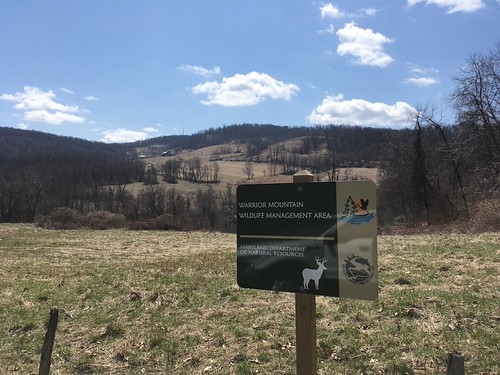
    Adding 18.86 acres to Chesapeake Forest Lands in Worcester County, to be managed as working forestland; acquiring a 367.73-acre conservation easement in Talbot County’s Lower Choptank River watershed, which will include public trail access; and adding 204.43 acres to the Warrior Mountain Wildlife Management Area in Allegany County to expand public recreation opportunities.

    Additional acquisitions include a 144-acre property near Assateague State Park in Worcester County for passive recreation; a 20.6-acre forest near St. Mary’s River State Park to protect bird habitat; and 390.43 acres in St. Mary’s County to be managed by the Maryland Forest Service as working forestland with public recreation access.

    The three-member Board of Public Works consists of Governor Wes Moore, Treasurer Dereck E. Davis, and Comptroller Brooke E. Lierman.

    Program Open Space – Local has been in operation since 1969 and is funded through a property transfer tax. It provides money to county and municipal governments for planning, acquiring, and developing recreational land and facilities, with each county receiving an annual allocation.

  • DSU Hosts Career and Workforce Readiness Event for Students and Community

    DSU Hosts Career and Workforce Readiness Event for Students and Community

    Delaware State University recently served as the host for a Community Thrive event centered on career readiness and workforce development.

    The gathering drew together a diverse group of participants, including current students, alumni, employers, and members of the surrounding community, all coming together to explore opportunities for professional growth and development.

    The event was designed to connect attendees with resources and experiences aimed at preparing them for success in today’s workforce.

  • Rip Current Warning in Effect for Local Beaches Through Wednesday Evening

    Rip Current Warning in Effect for Local Beaches Through Wednesday Evening

    The National Weather Service office in Mount Holly, New Jersey has issued a Rip Current Statement in effect from 12:25 PM through 8:00 PM EDT on Wednesday, June 18.

    Rip currents are powerful, fast-moving channels of water that flow away from shore and can quickly pull swimmers out to sea. They are one of the leading hazards for beachgoers along the Atlantic coast.

    Authorities urge anyone heading to the beach to be aware of current conditions and to swim only in areas monitored by lifeguards. If caught in a rip current, experts advise swimmers not to fight the current by swimming directly back to shore, but instead to swim parallel to the shoreline until free of the current, then make their way back to the beach.

    The statement is in effect through the evening hours. Residents and visitors planning beach trips are encouraged to check the latest forecasts from the National Weather Service before heading out.

  • DNREC Cuts Ribbon on New State Environmental Lab Near Smyrna

    DNREC Cuts Ribbon on New State Environmental Lab Near Smyrna

    Delaware’s Department of Natural Resources and Environmental Control has officially unveiled its new Delaware Environmental Laboratory, situated near Smyrna.

    The facility is described as a state-of-the-art testing center capable of analyzing water quality, identifying chemical contaminants — including per- and polyfluoroalkyl substances, commonly known as PFAS — and conducting both molecular and microbiology research.

    DNREC Secretary Greg Patterson presided over a ceremonial ribbon cutting to mark the occasion. He was joined by members of Delaware’s congressional delegation, state legislators, former DNREC cabinet secretaries, and representatives from various organizations that rely on the environmental lab for scientific analysis and data.

  • Gold Alert Issued for Missing 17-Year-Old Elias Del Valle in New Castle

    Gold Alert Issued for Missing 17-Year-Old Elias Del Valle in New Castle

    The New Castle County Division of Police has issued a Gold Alert for a missing 17-year-old identified as Elias Del Valle, a resident of New Castle, Delaware.

    Del Valle was last seen departing his home in the unit block of Kingston Road at around 8:57 a.m. on Tuesday, June 2, 2026. He is described as a black male.

    Anyone with information on his whereabouts is urged to contact authorities immediately.

  • UD Softball Roster Gets Boost with Virginia Tech Transfer Charlotte Moore

    UD Softball Roster Gets Boost with Virginia Tech Transfer Charlotte Moore

    The University of Delaware softball team is welcoming a new face to its lineup ahead of the 2027 season.

    Charlotte Moore, an outfielder who spent time at Virginia Tech, has transferred to Delaware and will suit up for the Blue Hens starting in 2027.

  • Delaware Plants 61,000+ Trees in First Year of Forest Resiliency Fund

    Delaware Plants 61,000+ Trees in First Year of Forest Resiliency Fund

    One of the earliest lessons in forestry education involves what’s known as the “4 W’s” — wood, water, wildlife, and recreation. While those four concepts offer a starting point for understanding why forests matter, they only scratch the surface. Forests clean the air, store carbon, protect water supplies, soften the blow of extreme weather events, and deliver a wide range of environmental, economic, and recreational benefits to communities and wildlife alike.

    Right now, Delaware’s forests are under pressure from multiple directions. Urban and suburban development, a shifting climate, invasive species, and the threat of wildfire are all taking a toll on the health of forested land across the state. Tackling these challenges calls for hands-on management and sustained investment in forest restoration and conservation efforts.

    Fortunately, land managers have a growing toolkit to work with. Prescribed burns can reduce the buildup of combustible materials and lower the chances of a devastating wildfire. Controlling invasive species opens the door for native plants and animals to flourish. Planting new trees — whether restoring previously forested land or establishing forests where none existed — can create diverse, native woodlands better suited to handle whatever environmental pressures lie ahead.

    To help make that work possible, the Delaware Forest Service created the Forest Resiliency Fund, a program that offers financial assistance to landowners who carry out practices aimed at boosting forest health across Delaware. The program is open to landowners with fewer than 10,000 acres of forestland in the state, including private individuals, municipalities, county governments, and homeowners associations. Projects must cover at least three acres to qualify.

    The Delaware Forest Service has now completed its first planting season through the Forest Resiliency Fund — a significant milestone for the young program. In that inaugural season, approximately 61,698 tree seedlings were put in the ground, resulting in around 142 acres of newly established forest throughout the state. Work was carried out on private properties as well as land belonging to Sussex County and the City of Lewes.

    Key accomplishments from the first planting season include:

    — 51 acres of mixed native hardwood forest planted on Sussex County property.
    — 23 acres of new forest established for two private landowners in Sussex County.
    — Nearly one mile of streamside buffer in Kent County converted from a single-species pine stand into a diverse native hardwood forest.
    — 11 acres of new forest added to City of Lewes property.
    — An additional 9 acres of new forest created for private landowners in Kent County.

    The benefits from these projects are expected to last for generations. The newly planted forests will support wildlife habitat, improve water quality, capture more carbon from the atmosphere, and make Delaware’s natural landscapes more resilient overall. Perhaps most significantly, they represent a meaningful commitment to ensuring that future Delawareans can continue to depend on — and enjoy — healthy, thriving forests.

    As the Forest Resiliency Fund expands, the Delaware Forest Service says it looks forward to working with additional landowners and communities to restore, protect, and grow Delaware’s forests, building a stronger and more resilient natural landscape for everyone across the state.

  • Tropical Storm Arthur Remnants Drench Gulf States as Midwest Cleans Up After Tornadoes

    Tropical Storm Arthur Remnants Drench Gulf States as Midwest Cleans Up After Tornadoes

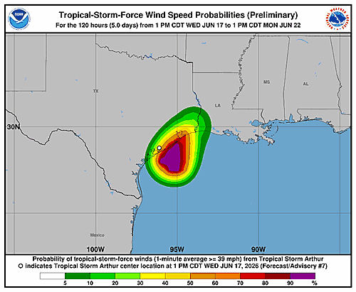
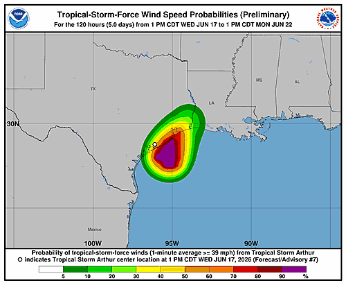
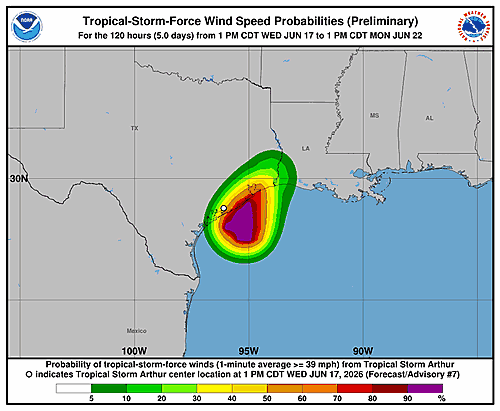
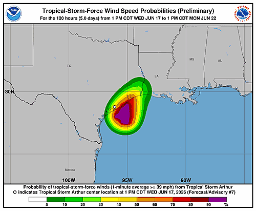
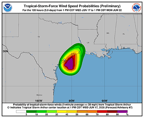
    What’s left of Tropical Storm Arthur continued causing problems Thursday, drenching parts of the southeastern United States with heavy rainfall and setting off flash flood and tornado warnings along the Gulf Coast.

    At the same time, residents across parts of Illinois, Indiana, and northern Kentucky were dealing with the aftermath of a fierce storm system that swept through the region Wednesday, bringing what may have been tornadoes, destroying homes, and knocking down trees and power lines.

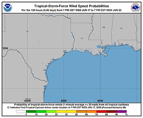
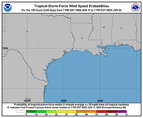
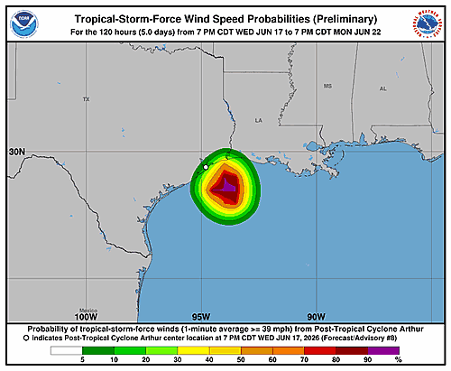
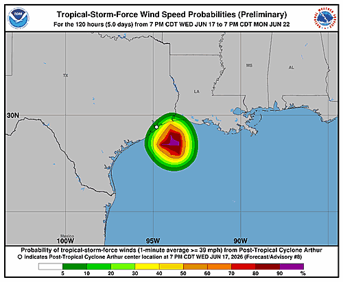
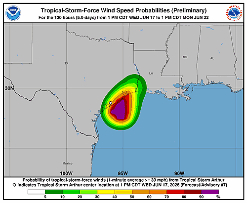
    Arthur, which holds the distinction of being the Atlantic basin’s first tropical storm of the season, was knocked down to a low pressure system near the upper Texas coast Wednesday night. The National Hurricane Center in Miami said it will continue to lose strength as it pushes inland through Louisiana, Mississippi, Alabama, Georgia, and the Florida Panhandle — though it will still drop significant amounts of rain along the way.

    The National Weather Service reported that southern Louisiana and Mississippi were receiving rainfall at a rate of 3 inches — about 8 centimeters — per hour in certain locations Thursday morning. Flooded streets were visible in television coverage and social media posts from the area. Multiple tornado warnings were issued Thursday morning across southern Louisiana and Mississippi, and tens of thousands of homes and businesses lost power.

    The weather service warned that Arthur’s remnants could dump 4 to 8 inches — or 10 to 20 centimeters — of rain, and possibly more, across Gulf states through Thursday and Friday. Texas had already seen flash flooding Wednesday, on top of heavy rain that had already hit the region earlier in the week.

    National Hurricane Center director Michael Brennan described the primary danger: “The main threat from Arthur is going to be a prolonged, multiday, heavy rainfall event that could produce dangerous to life-threatening flash flooding.”

    In New Orleans, Mayor Helena Moreno said ahead of the storm’s arrival that police were getting boats ready and placing barricades in areas known to flood. Sandbag collection sites also appeared throughout Louisiana for residents to prepare.

    One resident, Luke Barwick, explained why he stopped by a sandbag station in Covington, Louisiana, on Wednesday: “We both decided we got so much rain yesterday at our house that it was probably a good idea just to pick up a few bags.”

    Back in the Midwest, there were many reports of tornado and wind damage, though no deaths or serious injuries were immediately confirmed. As of Thursday morning, more than 130,000 homes and businesses in Illinois, Indiana, Kentucky, and Ohio were without electricity, according to poweroutage.us.

    A tornado touched down near Effingham, Illinois — roughly 90 miles, or 145 kilometers, southeast of Springfield — on Wednesday evening. A number of people were treated for minor injuries, officials confirmed.

    Effingham Fire Chief Brant Yochum released a statement describing the scope of the destruction: “A tornado caused significant damage in areas north of the City of Effingham, impacting homes, roadways, utilities, and other property throughout portions of Effingham County.”

    Yochum added that firefighters were kept busy responding to damaged and collapsed structures, vehicle accidents, downed power lines, gas leaks, and roads blocked by debris.

    An automobile museum and auto parts complex in Effingham announced on Facebook that it suffered what it called “catastrophic” damage, though fortunately no injuries were reported.

    The National Weather Service also noted that a tractor-trailer overturned on Interstate 57 north of Effingham, sending the driver to the hospital with injuries.

    In Florence, Kentucky, near the Cincinnati area, local news footage and photos showed roofs and siding torn from buildings, along with downed trees and power lines, following reports of strong winds and a possible tornado.

    Possible tornadoes were also reported Wednesday in southwestern Wisconsin and in Alabama. The weather service said it received a large number of wind damage reports spanning a broad area stretching from Iowa and Missouri all the way to Ohio and West Virginia.

    The storm system was forecast to continue moving through the central Appalachians and into New England on Thursday, the weather service said.

  • UD Volleyball Reveals Full 2026 Schedule with 12 Home Matches

    UD Volleyball Reveals Full 2026 Schedule with 12 Home Matches

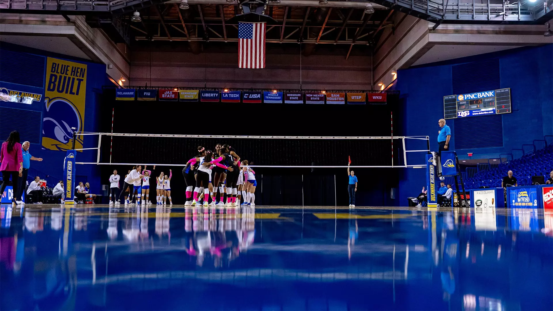
    The University of Delaware volleyball team now has its 2026 roadmap in place. Head coach Kim Lambert announced Thursday that the Fightin’ Blue Hens will compete in 26 regular-season matches throughout the upcoming campaign.

    Delaware fans will have plenty of chances to cheer on their team in person, as 12 of those matches are set to be played at home inside the Bob Carpenter Center.

  • Three UD Field Hockey Players Selected for 2026 Senior Nexus Championship

    Three UD Field Hockey Players Selected for 2026 Senior Nexus Championship

    Three Blue Hens are heading to a national stage. University of Delaware field hockey players Ella Cellini, Katie Clarke, and Penelope Kousouris have been chosen to take part in the 2026 Senior Nexus Championship, USA Field Hockey revealed Wednesday.

    The announcement was made in Virginia Beach, Virginia, marking a significant achievement for the trio of student-athletes from the University of Delaware program.

  • Delaware Farm Bureau Member Represents State at National Women in Ag Summit

    Delaware Farm Bureau Member Represents State at National Women in Ag Summit

    Written by Maci Dickerson, Delaware Farm Bureau

    More than 500 women from across the United States gathered in Washington, D.C. for the 2026 ACE Summit — short for Advocate, Cultivate, Empower — an event organized by the American Farm Bureau Federation Women’s Leadership program. The conference took place in recognition of the International Year of the Woman Farmer, making it a particularly meaningful gathering for those who attended.

    The opening session featured a panel of women in leadership roles who were part of the original group that launched the International Year of the Woman Farmer campaign more than a decade ago. Hearing the story behind how that global movement came together was described as a deeply inspiring experience.

    Throughout the conference, attendees took part in breakout sessions designed to strengthen their advocacy and media communication skills. One session focused on how women in agriculture can speak clearly and confidently on behalf of the industry when engaging with media outlets. Another session encouraged participants to pursue their ambitions with purpose, offering practical tools to shift from a mindset of self-discipline toward one of self-devotion.

    The summit wrapped up with a presentation of results from the National Women in Agriculture Study, which collected more than 4,000 responses. The survey painted a detailed picture of the wide range of responsibilities and skills that women in agriculture bring to the table. Among the standout findings: nine out of ten women surveyed said they feel confident speaking about agriculture at community meetings — a result that highlighted just how prepared women in the industry are to tell their own stories.

    Following the summit, attendees participated in Women in Ag Day on Capitol Hill, where they had the opportunity to meet with members of both the U.S. House and Senate representing their home states. With the Farm Bill currently under review by the Senate Agriculture Committee, the timing made these conversations especially important for Delaware Farm Bureau members to be part of.

    The experience left attendees energized and motivated to make a difference back home. Women are widely recognized as a cornerstone of the agriculture industry, and the summit served as a reminder of the strength that comes from community — whether within one’s own family or through the broader Farm Bureau network.

  • Salisbury to Begin Naylor Mill Water Main Extension in Late June

    Salisbury to Begin Naylor Mill Water Main Extension in Late June

    SALISBURY, Md. — The City of Salisbury has officially announced plans for the Naylor Mill Water Main Extension Project, with an outside contractor set to break ground on Monday, June 29, 2026. The project is expected to take about a year, with completion targeted for June 2027.

    The goal of the project is to expand water service and deliver dependable, high-quality drinking water to the surrounding area. The work will span from Scenic Drive to Ed Taylor Road and is part of the city’s ongoing push to upgrade its water infrastructure and improve service reliability.

    Drivers should be aware that while the road will stay open during construction, traffic will be managed under single-lane control. Motorists are asked to slow down, plan for potential delays, and pay close attention to posted signs and flagging crews working in the construction zone.

    Work is scheduled to take place Monday through Friday, between 7 a.m. and 5 p.m.

    The city is asking for the public’s patience as the project moves forward and says additional updates will be shared as construction progresses. Residents with questions can reach the Water Works Department at 410-548-3199.

  • Supreme Court Rules Marijuana Users Have Right to Own Guns

    Supreme Court Rules Marijuana Users Have Right to Own Guns

    WASHINGTON — The U.S. Supreme Court handed down a unanimous ruling Thursday in favor of a Texas marijuana user who challenged his right to legally possess a firearm, marking the latest in a growing series of decisions that have broadened gun rights across the country.

    The justices ruled in favor of Ali Danial Hemani, who contended that a federal law prohibiting anyone who uses illegal drugs from owning a gun runs afoul of the Second Amendment. Hemani had not been accused of any other criminal activity, nor was he alleged to have handled the firearm while under the influence of marijuana.

    The ruling is a setback for President Donald Trump’s Republican administration, which had defended the 1968 law even as it has pushed back against other firearms restrictions. That same law played a central role in the case against Hunter Biden, who was convicted in Wilmington, Delaware, of purchasing a firearm while addicted to cocaine in 2018. He was subsequently pardoned by his father, then-President Joe Biden, a Democrat.

    Thursday’s decision is the most recent in a string of gun-related cases to reach the nation’s highest court following a landmark 2022 ruling that expanded Second Amendment protections and sparked a nationwide wave of legal challenges.

    In the years since that 2022 ruling, the Supreme Court has upheld a law designed to shield domestic violence victims and maintained strict regulations on ghost gun kits, while striking down a prohibition on bump stocks — attachments that allow semi-automatic weapons to fire at a much faster rate. The court took up two separate firearms cases during this term alone.

    The legal landscape surrounding marijuana has also undergone major changes in recent years. More than half of all U.S. states have now broadly legalized cannabis, and its use for medical purposes has become widespread. Nevertheless, recreational marijuana remains illegal at the federal level, even following the Trump administration’s move in April to reclassify medical marijuana as a less-dangerous substance.

    Standalone criminal charges against individuals accused solely of possessing guns while using drugs are uncommon. In most cases, that charge is added on top of other alleged offenses.

    The case drew some unexpected political alliances. Both the American Civil Liberties Union and the National Rifle Association filed in support of Hemani, as did cannabis legalization advocates including NORML. Opposing Hemani were gun safety organizations such as Everytown, which typically find themselves on the opposite side of the Trump administration when it comes to Second Amendment debates.

  • Extreme Drought Expands Across Delmarva as Rainfall Deficits Continue

    Extreme Drought Expands Across Delmarva as Rainfall Deficits Continue

    GEORGETOWN, Del. — The latest U.S. Drought Monitor update shows drought conditions continuing to worsen across portions of the Delmarva Peninsula, with areas of Extreme Drought (D3) expanding as the region struggles with persistent rainfall deficits and increasing moisture loss from above-normal temperatures.

    The newest drought assessment indicates that much of Delaware and portions of Maryland’s Eastern Shore remain locked in severe to extreme drought conditions. The expansion of Extreme Drought is the latest sign that recent scattered showers and thunderstorms have done little to address the long-term moisture shortages that have developed across the region.

    According to drought monitoring data, Delaware has experienced a prolonged stretch of below-normal precipitation, while streamflows, groundwater levels, and soil moisture continue to run well below average. State climatologists have noted that precipitation deficits have persisted for several months, with many locations still waiting for meaningful widespread rainfall.

    The worsening drought is becoming increasingly noticeable across Delmarva. Lawns and agricultural fields continue to show signs of stress, ponds and streams remain below normal levels, and wildfire concerns have increased due to the combination of dry vegetation and periodic stretches of hot weather. Recent drought assessments have highlighted continued expansion of drought conditions across Delaware and southeastern Maryland as rainfall has frequently missed the region.

    The broader Mid-Atlantic has also seen drought conditions intensify during recent weeks. National drought monitoring reports show Severe Drought (D2) expanding across portions of the Mid-Atlantic and Northeast as widespread heat and below-normal precipitation continue to impact the region.

    Looking ahead, significant improvement will likely require multiple widespread soaking rainfall events over an extended period. While scattered thunderstorms can provide localized relief, they often fail to produce the widespread rainfall necessary to reverse long-term drought conditions. Until a wetter weather pattern develops, drought impacts across Delmarva are expected to persist and could continue to worsen during the summer months.

    Residents are encouraged to remain mindful of water conservation efforts and local burn restrictions, especially as dry conditions continue to increase fire danger across the region.

  • Rehoboth Beach Invites Public to Shape City’s Zoning Future During Charrette Week

    Rehoboth Beach Invites Public to Shape City’s Zoning Future During Charrette Week

    Rehoboth Beach is moving forward with a commercial zoning code overhaul, and city officials want the public to be part of the conversation. The city has joined forces with planning and design firm Dover Kohl & Partners to guide the update, which aims to address existing problems and strengthen the character and community life of Rehoboth Beach.

    A key part of that effort is Charrette Week, a community-driven planning event set to take place July 13-17 at the Rehoboth Beach Convention Center. A charrette is a collaborative planning session where community members, stakeholders, and planners work together to identify challenges and develop solutions.

    The week is designed to give residents, business owners, property owners, visitors, and anyone who cares about the city’s future a direct voice in the planning process. A range of activities will be offered throughout the week to make participation as accessible and engaging as possible.

    Walking Tours will take participants through key streets and public spaces, encouraging them to take a closer look at the built environment — how buildings relate to the sidewalk, how safe and welcoming spaces feel, and how design decisions affect the overall character of a place. Participants will also have the chance to share stories about past issues and how they were handled.

    Interactive Map Sessions will give attendees a chance to act as planners themselves. Large maps will be spread out and markers handed out so that participants can draw ideas, flag concerns, and mark opportunities directly on the map. All input will be recorded so nothing is overlooked.

    Drop-In Studio Hours will allow anyone to stop by at their convenience to see the planning team at work — sketching concepts and visualizing early ideas based on feedback gathered throughout the week. Visitors can ask questions, share thoughts, or simply observe the process informally.

    Focus Meetings will zero in on specific topics or groups, though all of these sessions are open to anyone who wishes to attend.

    End-of-Week Summary — At the close of Charrette Week, the team will present a recap of what was heard and share some initial concepts that emerged from community input. This presentation will lay the groundwork and policy direction that will ultimately guide how the new zoning code is written.

    The week gets underway on Monday, July 14, with a Kick-Off Meeting from 4:00 to 7:00 p.m. at the Convention Center. Attendees will have the chance to meet the Dover Kohl & Partners team, learn about the initiative, and provide hands-on feedback.

    Sessions will continue Tuesday through Thursday, running as early as 8:00 a.m. and wrapping up by 6:00 p.m. At the conclusion of the week, Dover Kohl & Partners will deliver a Progress Presentation at 2:00 p.m. during the Mayor & Commissioners Meeting. That meeting is open to the public and will also be livestreamed and archived on the city’s YouTube channel for those who cannot attend in person.

    A full schedule, along with additional information, videos, and frequently asked questions, is available on the city’s official website under the Zoning Code Changes section. Members of the media are welcome to attend all sessions.

    For more information, contact Communications Director Brooke Thaler at 302-227-6181, ext. 522.

  • Gunfire Hits Dover Home and Parked Car on Barrister Place

    Gunfire Hits Dover Home and Parked Car on Barrister Place

    The Dover Police Department is currently investigating a shooting that took place late Wednesday night in the 400 block of Barrister Place, where both a home and a parked car were struck by gunfire.

    Officers were called to the area around 11:31 p.m. on June 17th, 2026, following reports of shots fired. When they arrived, they discovered that an unoccupied vehicle had been hit by gunfire, and a nearby occupied residence had been struck two to three times.

    At the time of the shooting, six people were inside the home. Fortunately, none of them were injured.

    The investigation remains active and ongoing. Anyone who may have information about this incident is encouraged to reach out to the Dover Police Department at (302) 736-7145. Callers can choose to remain anonymous. Tips can also be submitted through Delaware Crime Stoppers by calling 800-TIP-3333 or by visiting www.delaware.crimestoppersweb.com online. A cash reward may be offered for any information that leads to an arrest.

  • Lane Shift in Effect on Rogers Rd Between New Castle Ave and S Heald St Until 4PM

    Lane Shift in Effect on Rogers Rd Between New Castle Ave and S Heald St Until 4PM

    A lane shift is currently in effect on Rogers Road between New Castle Avenue and South Heald Street, according to traffic officials.

    The lane adjustment is expected to remain active until 4:00 PM. Drivers traveling through the area should use caution and be prepared for altered traffic patterns.

    Motorists are encouraged to allow additional travel time or consider alternate routes if possible until the lane shift is lifted.

  • Route 13 North Shoulder Closed Between Voshells Mill Rd and Willow Grove Rd Until 4PM

    Route 13 North Shoulder Closed Between Voshells Mill Rd and Willow Grove Rd Until 4PM

    Travelers heading northbound on Route 13 should be aware of a right shoulder closure currently in effect between Voshells Mill Road and Willow Grove Road.

    The lane restriction is the result of ongoing construction activity in the area. DelDOT reports the closure is expected to be lifted by 4:00 PM.

    Motorists are advised to use caution when passing through the affected stretch and to expect possible delays during the closure window.

  • Lane Shift in Effect on Rogers Rd Between New Castle Ave and S Heald St Until 4PM

    Lane Shift in Effect on Rogers Rd Between New Castle Ave and S Heald St Until 4PM

    A lane shift is currently in effect on Rogers Road between New Castle Avenue and South Heald Street, according to traffic officials.

    The lane shift is associated with work being performed in the area and is expected to remain active until 4:00 PM.

    Drivers passing through that stretch of road are encouraged to slow down, stay alert, and allow extra travel time as crews work in the vicinity.

  • Lane Closure in Effect at Jupiter Dr & Venus Dr Until 4 PM

    Lane Closure in Effect at Jupiter Dr & Venus Dr Until 4 PM

    Travelers passing through the intersection of Jupiter Drive and Venus Drive should be aware of intermittent lane closures currently in effect due to construction work in the area.

    According to traffic officials, the lane restriction is expected to remain active until 4 p.m. Drivers are encouraged to use caution when passing through the work zone and to budget additional time for their commute if their route takes them through that area.

    No further details about the nature of the construction work were immediately available. Motorists should stay alert for flaggers or signage directing traffic through the area.

  • Right Lane Closed on E. Newport Pike in Newark Until 5 PM

    Right Lane Closed on E. Newport Pike in Newark Until 5 PM

    Westbound travelers on East Newport Pike in Newark are facing a right lane closure this afternoon due to construction activity in the area.

    The lane restriction is located between Cedar Street and North Walnut Street. Drivers using that stretch of road should expect some congestion and may want to consider an alternate route.

    The closure is expected to remain in place until 5 PM, at which point the lane is scheduled to reopen. DelDOT is the source of the traffic alert.

  • Road Work Alert: Bryants Corner Rd Closed to Mobile Operation Until 1PM

    Road Work Alert: Bryants Corner Rd Closed to Mobile Operation Until 1PM

    Motorists traveling on Bryants Corner Road (Road 103) should be aware of a mobile operation currently working in the area.

    The work zone is located between Pine Tree Road (Road 217) and Holly Island Road (Road 191). The operation is expected to remain active until 1:00 PM.

    Drivers are encouraged to use caution when passing through the area or consider alternate routes to avoid any potential delays.

  • Left Shoulder Closed on E Main St Westbound Due to Construction

    Left Shoulder Closed on E Main St Westbound Due to Construction

    Drivers heading westbound on East Main Street should be aware of an active lane restriction currently in place due to construction activity.

    The left shoulder on East Main Street westbound, between Tyre Avenue and Washington Street, is closed as crews work in the area. The closure is scheduled to remain in effect until 3 PM.

    Motorists are advised to slow down and use caution when passing through the affected stretch of roadway. Drivers may want to consider alternate routes to avoid potential delays.

  • UN Agencies Request $202M to Protect Millions from Approaching El Niño

    UN Agencies Request $202M to Protect Millions from Approaching El Niño

    Two major United Nations food agencies are urgently requesting $202 million to help shield 8.8 million people across 22 high-risk nations from the growing threat of an El Niño weather event. The appeal was made Thursday by the UN’s Food and Agriculture Organization and the World Food Programme.

    The two agencies warn that strong El Niño conditions expected during the second half of 2026 could significantly increase the chances of drought, flooding, and powerful storms across regions of Africa, Asia, the Pacific, and Latin America and the Caribbean.

    The 22 countries identified as most vulnerable include Cameroon, Ethiopia, Kenya, Madagascar, Malawi, Mozambique, Nigeria, Somalia, South Sudan, Sudan, Uganda, and Zimbabwe on the African continent. In the Asia-Pacific region, Afghanistan, Pakistan, the Philippines, and East Timor are listed among those at greatest risk. Rounding out the list are Colombia, El Salvador, Guatemala, Haiti, Honduras, and Venezuela in Latin America and the Caribbean.

    The agencies noted that securing the requested funding would allow them to expand their reach beyond the 1.2 million people already being targeted for assistance. Planned aid measures include cash transfers, seeds designed to withstand climate stress, protection for livestock, and flood control efforts.

    El Niño is a naturally occurring weather phenomenon caused by a warming of sea surface temperatures in the eastern Pacific Ocean, triggered by a weakening of trade winds. It typically occurs every two to seven years and generally lasts between nine and twelve months.

    The U.S. National Oceanic and Atmospheric Administration officially declared El Niño’s arrival last week, adding that conditions are likely to grow stronger. The agency placed the probability of a very strong or so-called ‘super El Niño’ developing heading into 2027 at 63%.

  • Your Delmarva Forecast: Thursday, June 18, 2026

    Your Delmarva Forecast: Thursday, June 18, 2026

    Good morning, Delmarva! It’s going to be a hot and breezy one out there today. Expect partly sunny skies this morning with temperatures climbing to a steamy high near 94°F. Southwest winds will be gusty, reaching up to 35 mph, so secure any loose outdoor furniture. By mid-afternoon, we’re watching a chance of showers and thunderstorms developing — roughly between 2 and 5 p.m. — so if you have outdoor plans, try to wrap them up before then. Storm chances linger into the evening, though rainfall totals should remain light. Overnight, expect mostly cloudy skies with a low near 69°F. Tomorrow is Juneteenth, and we’re tracking another round of possible showers and thunderstorms in the morning. The good news? Skies should clear out by afternoon with a more comfortable high near 84°F. Friday night looks beautiful — clear skies and a pleasant low of 65°F. Stay cool, stay safe, and keep that umbrella handy today! I’ll have updates throughout the day right here on TV Delmarva.
  • Post-Tropical Cyclone Arthur Wind Probability Update Issued

    Post-Tropical Cyclone Arthur Wind Probability Update Issued

    The National Hurricane Center has issued updated wind speed probability graphics for Post-Tropical Cyclone Arthur, providing forecasters and the public with the latest information on potential wind impacts.

    The graphics display the probability of 34-knot wind speeds affecting different regions over a 120-hour period. According to the National Hurricane Center, the wind speed probabilities were last updated on Thursday, June 18, 2026, at 3:20 a.m. GMT.

    Residents are encouraged to monitor the latest updates from the National Hurricane Center as conditions continue to be assessed.

  • Gold Alert Canceled: Shayone Teachy Has Been Found

    Gold Alert Canceled: Shayone Teachy Has Been Found

    Authorities have canceled a Gold Alert that had been issued for Shayone Teachy after the individual was successfully located.

    Officials confirmed that Teachy has been found, bringing the alert to a close. No additional information was released regarding the circumstances of the case.

  • Right Lane Closed on I-495 Northbound Between Exits 2 and 3

    Right Lane Closed on I-495 Northbound Between Exits 2 and 3

    Drivers heading northbound on Interstate 495 should be aware of a lane restriction currently in effect due to construction activity.

    The right lane between exits 2 and 3 is closed as part of an ongoing construction project. The closure is scheduled to remain in place until 5:00 a.m.

    Motorists traveling through the affected stretch are advised to allow extra travel time and remain alert for construction crews and equipment in the area.

  • Rip Current Warning in Effect for Delmarva Beaches Through Wednesday Evening

    Rip Current Warning in Effect for Delmarva Beaches Through Wednesday Evening

    A Rip Current Statement has been issued by the National Weather Service out of Mount Holly, New Jersey, taking effect at 4:22 AM on Wednesday, June 18, and remaining in place through 8:00 PM that same evening.

    Rip currents are powerful, fast-moving channels of water that can pull swimmers away from shore quickly. They are one of the leading causes of drowning deaths at beaches each year.

    Residents and visitors planning to spend time at local beaches on Wednesday should be aware of the elevated risk. Swimmers caught in a rip current are advised not to fight the current by swimming directly back to shore, but instead to swim parallel to the shoreline until free of the current, then make their way back to the beach.

    The National Weather Service recommends only swimming at beaches with a lifeguard on duty during periods when rip current alerts are active.

  • Hong Kong Issues Highest Rain Alert, Shuts Schools Amid Severe Flooding Risk

    Hong Kong Issues Highest Rain Alert, Shuts Schools Amid Severe Flooding Risk

    Hong Kong’s weather observatory issued its most severe rain warning — known as the black rain signal — on Thursday at 12:55 p.m. local time, ordering schools to close and pushing some businesses to suspend operations as officials warned residents to find shelter and prepare for serious flooding.

    The observatory reported on its website that heavy rainfall exceeding 70 millimeters per hour was expected to persist. This marks the second time this year the black rain signal has been activated, with the first occurrence happening just over a week earlier on June 8.

    The major financial city, along with much of southern China, has endured several consecutive days of soaking rain driven by an active southwest monsoon and a persistent low-pressure trough in the region.

    Strong wind gusts have also been battering the city, with speeds of approximately 80 kilometers — about 50 miles — per hour recorded in Hong Kong’s southwestern district of Tai O, according to the observatory.

    The severe weather arrives at an especially inconvenient time, falling just before the Dragon Boat Festival on Friday, which kicks off a three-day weekend during which large numbers of residents are expected to be traveling.

    Just across the border in Shenzhen, mainland China, local authorities issued a red rain signal and called on residents to avoid low-lying areas, waterlogged zones, and what officials described as “other dangerous areas.” Officials there also warned of a heightened risk of mountain floods, landslides, and other related disasters.

  • Right Lane Closed on Route 896 NB for Overnight Construction

    Right Lane Closed on Route 896 NB for Overnight Construction

    Motorists traveling northbound on Route 896 are facing a lane closure overnight due to construction activity.

    The right lane between South Old Baltimore Pike and Ramp J is shut down and is expected to remain closed until 6 a.m.

    Drivers in the area are advised to plan accordingly and allow extra time for their commute.

  • Post-Tropical Cyclone Arthur Wind Probability Forecast Released

    Post-Tropical Cyclone Arthur Wind Probability Forecast Released

    The National Hurricane Center has released updated wind speed probability graphics for Post-Tropical Cyclone Arthur, providing forecasters and the public with the latest outlook on potential wind impacts.

    The imagery depicts the probability of 34-knot wind speeds affecting different regions as the storm system continues to be monitored. These graphics are a standard tool used by meteorologists to communicate the range of possible storm impacts.

    According to the National Hurricane Center, the wind speed probability graphics were last updated on Thursday, June 18, 2026, at 3:20 a.m. GMT. Residents in potentially affected areas are encouraged to monitor official forecasts for the latest information as conditions may change.

  • Post-Tropical Cyclone Arthur Wind Probability Forecast Issued

    Post-Tropical Cyclone Arthur Wind Probability Forecast Issued

    The National Hurricane Center has issued updated wind speed probability graphics for Post-Tropical Cyclone Arthur, providing forecasters and the public with the latest outlook on the storm system.

    The graphics display the probability of 34-knot wind speeds occurring across the storm’s projected path over a 120-hour period. These probability maps are a standard tool used by meteorologists to communicate the likelihood of hazardous winds reaching specific areas.

    The wind speed probability information was last updated Thursday, June 18, 2026, at 2:51 a.m. GMT, according to the National Hurricane Center.

  • Former Tropical Storm Arthur Weakens to Low Pressure System Near Texas Coast

    Former Tropical Storm Arthur Weakens to Low Pressure System Near Texas Coast

    What was once Tropical Storm Arthur has weakened significantly, now classified as a low pressure area hugging the upper Texas coast.

    According to the National Hurricane Center, as of 10:00 PM CDT on Wednesday, June 17, the center of the system was positioned near coordinates 29.7 degrees north, 94.5 degrees west, moving to the northeast at approximately 9 miles per hour.

    The storm’s minimum central pressure was recorded at 1000 millibars, with maximum sustained winds of around 35 miles per hour — down from its peak tropical storm intensity.

    Even though Arthur has lost its tropical storm classification, forecasters are warning that life-threatening flooding remains a serious concern for portions of the southeastern United States. Residents in affected areas are urged to remain cautious and stay informed through local emergency management officials.

  • Post-Tropical Cyclone Arthur Dissipates, Final Advisory Issued

    Post-Tropical Cyclone Arthur Dissipates, Final Advisory Issued

    The National Hurricane Center in Miami issued its final forecast advisory for Post-Tropical Cyclone Arthur at 3:00 a.m. UTC on Thursday, June 18, 2026, signaling the end of active storm tracking for this system.

    At the time of the final advisory, the storm’s center was pinpointed near 29.7 degrees North latitude and 94.5 degrees West longitude, with that position considered accurate within 30 nautical miles. The system was moving toward the northeast at approximately 8 knots, or roughly 9 miles per hour.

    Arthur’s estimated minimum central pressure stood at 1,000 millibars, with maximum sustained winds of 30 knots and gusts reaching up to 40 knots at the time of the report.

    Forecasters indicated the storm was expected to fully dissipate by 12:00 p.m. UTC on Thursday. However, the National Hurricane Center noted that the remnants of Arthur could re-emerge over the Atlantic Ocean by Friday. If that occurs, additional information will be available through High Seas Forecasts issued by the National Weather Service.

    The advisory was the eighth and final one issued for this storm, designated AL012026. Forecaster Beven authored the final report. Ships within 300 nautical miles of the storm’s last known position were asked to submit reports every three hours.

  • Arthur Downgraded to Post-Tropical Low, Still Threatens Southeast with Flooding

    Arthur Downgraded to Post-Tropical Low, Still Threatens Southeast with Flooding

    The National Hurricane Center announced Wednesday night that Arthur has officially been downgraded from a tropical cyclone to a post-tropical low, after the storm’s structure broke down along the Upper Texas coastline.

    According to forecasters, surface observations showed that Arthur’s center briefly re-formed near Galveston between approximately 9 and 10 p.m. Eastern time Wednesday following an offshore burst of thunderstorm activity. However, organized storm activity near the center soon disappeared, and the circulation stretched out along the Upper Texas coast — prompting the downgrade. The system is now carrying maximum sustained winds of 30 knots.

    The storm’s path remains somewhat uncertain due to the center reformation, but forecasters estimate it is beginning to pick up speed, moving toward the northeast at around 8 knots. The surface center is expected to fall apart later Wednesday night over southeastern Texas or southwestern Louisiana. After that, the remnants of Arthur are forecast to track east-northeastward across the southeastern United States before emerging into the Atlantic Ocean on Friday, continuing out to sea from there.

    Although the surface center is expected to dissipate, global weather models indicate it could potentially re-form near the Atlantic coast on Friday, with some strengthening possible as it moves offshore. Forecasters say it remains unclear whether any redevelopment would result from tropical or non-tropical weather processes. As a precaution, marine gale warnings have been issued for portions of the western Atlantic.

    Despite losing its tropical cyclone designation, Arthur continues to pose significant dangers. Forecasters warn that heavy rainfall and life-threatening flash flooding will remain a major concern across the southeastern United States for the next several days. An elevated tornado risk is also in place for parts of the Southeast through Thursday.

    Key hazards outlined by forecasters include: potentially life-threatening flash flooding and urban flooding likely through Friday across southern Louisiana, southern Mississippi, southern Alabama, southwestern Georgia, and the Florida Panhandle; the possibility of scattered minor river flooding, with isolated moderate to major river flooding; wind gusts reaching tropical-storm force along portions of the Louisiana coast Wednesday night; and coastal flooding along the Texas and Louisiana coasts expected to gradually ease later tonight and into Thursday.

    Wednesday night’s update marks the final advisory the National Hurricane Center will issue on Arthur. Rainfall forecasts and flash flood risk outlooks for the storm’s remnants will continue to be available through the Weather Prediction Center.

  • Post-Tropical Cyclone Arthur Wind Speed Probabilities Issued by NHC

    Post-Tropical Cyclone Arthur Wind Speed Probabilities Issued by NHC

    The National Hurricane Center in Miami issued Wind Speed Probability Update Number 8 for Post-Tropical Cyclone Arthur at 3:00 a.m. Coordinated Universal Time on Thursday, June 18, 2026.

    At the time of the bulletin, the center of the post-tropical system was located near latitude 29.7 degrees north and longitude 94.5 degrees west. The storm was carrying maximum sustained winds of approximately 30 knots, which equals about 35 miles per hour or 55 kilometers per hour.

    The bulletin was designed to provide the probability of sustained wind speeds reaching at least 34 knots (39 mph), 50 knots (58 mph), and 64 knots (74 mph) at specific locations over the following five days. However, forecasters noted that no official forecast existed for the applicable date and time window, meaning no wind speed probability calculations could be generated for any of the listed locations.

    The update was issued by Forecaster Beven.

  • Post-Tropical Cyclone Arthur Wind Probability Forecast Issued

    Post-Tropical Cyclone Arthur Wind Probability Forecast Issued

    The National Hurricane Center has issued updated wind speed probability graphics for Post-Tropical Cyclone Arthur, providing forecasters and the public with the latest outlook on potential wind impacts.

    The graphics, which display the probability of 34-knot wind speeds over a 120-hour period, were last updated on Thursday, June 18, 2026, at approximately 2:51 a.m. GMT.

    Residents in areas that could be affected by the storm’s remnants are encouraged to monitor the latest updates from the National Hurricane Center as conditions continue to evolve.

  • Tropical Storm Arthur Wind Probability Forecast Issued

    Tropical Storm Arthur Wind Probability Forecast Issued

    The National Hurricane Center has issued updated wind speed probability graphics for Tropical Storm Arthur, the first named storm of the Atlantic hurricane season.

    The graphics, which were last updated on Wednesday, June 17, 2026, at 9:26 p.m. GMT, display the probability of 34-knot wind speeds occurring over a 120-hour forecast window.

    Forecasters are urging residents in potentially affected coastal areas to stay informed and continue monitoring official updates from the National Hurricane Center as the storm develops.

  • Tropical Storm Arthur Wind Probability Graphics Released

    Tropical Storm Arthur Wind Probability Graphics Released

    The National Hurricane Center has released updated wind speed probability graphics for Tropical Storm Arthur, providing a visual look at where the storm’s winds could have an impact.

    The graphics illustrate the probability of 34-knot wind speeds reaching different areas over a 120-hour forecast window, helping residents and emergency managers gauge potential risk zones.

    According to the National Hurricane Center, the wind speed probability data was last updated on Wednesday, June 17, 2026, at 9:26 p.m. GMT. Residents in potentially affected areas are encouraged to monitor the latest updates from official weather sources as the storm continues to develop.

  • I-495 South Ramp Closed Overnight for Construction Work

    I-495 South Ramp Closed Overnight for Construction Work

    Motorists traveling southbound on Interstate 495 should be aware of an overnight ramp closure currently in effect due to construction activity.

    The ramp from Exit 5A-B connecting to southbound Interstate 95 is closed as crews carry out construction work in the area. The closure is expected to remain in place until 5:00 AM.

    Drivers are encouraged to allow extra travel time and consider using alternate routes to avoid delays during the closure.

  • Salem Church Rd. Southbound Closed at Cornell Dr. Until 6 AM

    Salem Church Rd. Southbound Closed at Cornell Dr. Until 6 AM

    Salem Church Road southbound is currently closed at Cornell Drive due to ongoing construction activity.

    The road closure is expected to remain in place until 6 AM, at which point the roadway is anticipated to reopen to traffic.

    Drivers in the area are encouraged to seek alternate routes and plan accordingly to avoid delays during the closure period.

  • Tropical Storm Arthur Wind Probability Graphics Released

    Tropical Storm Arthur Wind Probability Graphics Released

    The National Hurricane Center has issued updated wind speed probability graphics for Tropical Storm Arthur, providing forecasters and the public with a visual look at where dangerous winds may develop over the coming days.

    The graphics depict the probability of 34-knot wind speeds occurring across affected areas within a 120-hour forecast window. These types of visuals help residents and emergency managers assess potential storm impacts and plan accordingly.

    The wind speed probability information was last updated on Wednesday, June 17, 2026, at 9:26 PM GMT. Residents in potentially affected coastal areas are encouraged to monitor the latest updates from the National Hurricane Center as the storm continues to develop.

  • Tropical Storm Arthur Brings Life-Threatening Flood Threat to Southeastern U.S.

    Tropical Storm Arthur Brings Life-Threatening Flood Threat to Southeastern U.S.

    Tropical Storm Arthur has re-formed near Galveston, Texas, and is now tracking toward the northeast, bringing with it the threat of life-threatening flooding across portions of the southeastern United States.

    According to the National Hurricane Center, as of 7:00 PM Central Daylight Time on Wednesday, June 17, the center of the storm was positioned near coordinates 29.4 degrees north, 94.9 degrees west. Arthur was moving to the northeast at approximately 8 miles per hour.

    The storm’s minimum central pressure was recorded at 1000 millibars, with maximum sustained winds of around 40 miles per hour.

    Forecasters are urging residents across the affected southeastern states to take the flooding threat seriously, as conditions could become dangerous. Residents in the storm’s path should monitor updates from local emergency management officials and the National Hurricane Center.

  • Tropical Storm Arthur Wind Probability Graphics Released

    Tropical Storm Arthur Wind Probability Graphics Released

    The National Hurricane Center has released updated wind speed probability graphics for Tropical Storm Arthur, providing forecasters and the public with a look at where tropical-storm-force winds may develop over the coming days.

    The graphics illustrate the probability of 34-knot winds — the threshold for tropical storm conditions — affecting different areas within a 120-hour forecast window.

    According to the National Hurricane Center, the wind speed probability data was last updated Wednesday, June 17, 2026, at approximately 9:26 p.m. GMT.

    Residents in coastal areas are encouraged to monitor the latest updates from the National Hurricane Center as the storm continues to develop.

  • UD Women’s Tennis Lands Top CUSA Recruiting Class for 2026

    UD Women’s Tennis Lands Top CUSA Recruiting Class for 2026

    The University of Delaware women’s tennis program is bringing in one of the top recruiting classes in the country for 2026, earning recognition as the best in Conference USA.

    According to tennisrecruiting.net, the Blue Hens landed the 18th-ranked mid-major recruiting class in the nation, topping all other programs in CUSA. The announcement was made this week.

  • Tropical Storm Arthur Threatens Life-Threatening Flooding Across Southeast U.S.

    Tropical Storm Arthur Threatens Life-Threatening Flooding Across Southeast U.S.

    Tropical Storm Arthur is posing a serious threat to communities across the southeastern United States, with forecasters warning of life-threatening flooding in the region.

    As of 4:00 PM CDT on Wednesday, June 17, the center of Arthur was positioned near coordinates 28.9 degrees north latitude and 96.1 degrees west longitude. The storm was tracking in a north-northeast direction at a forward speed of 7 miles per hour.

    Meteorologists recorded a minimum central pressure of 1,001 millibars, with maximum sustained winds reaching approximately 45 miles per hour.

    A Tropical Storm Warning continues to be in place for sections of the Texas and Louisiana coastlines. Residents in those areas are urged to take the flooding threat seriously and follow guidance from local emergency officials.

  • Right Lane Closed on Christiana Rd Westbound Until 3 PM

    Right Lane Closed on Christiana Rd Westbound Until 3 PM

    Westbound travelers on Christiana Road, also known as Route 273, are facing a right lane closure between Harmony Road and Cedarwood Road.

    The lane restriction is expected to remain in place until 3 PM. Drivers in the area should allow extra travel time or consider using an alternate route to avoid delays.

    No additional details regarding the cause of the closure have been provided at this time. Motorists are encouraged to stay alert and follow any posted traffic control signs in the work zone.

  • Minor Coastal Flooding Expected Overnight in New Castle County

    Minor Coastal Flooding Expected Overnight in New Castle County

    A Coastal Flood Advisory is in effect for New Castle County, Delaware, with minor tidal flooding expected in the overnight hours. The National Weather Service out of Mount Holly, New Jersey has issued the advisory, which runs from midnight tonight through 4 a.m. Thursday. Forecasters say up to half a foot of inundation above ground level is possible in low-lying areas near shorelines and tidal waterways. The biggest concern? Your morning commute. Flooding is expected to impact the most vulnerable roads along tidal waterways, and some partial or full road closures are possible. Authorities are urging residents to take precautions before the flooding begins. Do not leave your vehicle parked in areas prone to tidal flooding overnight. If you do encounter standing water on the road, turn around — do not attempt to drive through it. Water can be deeper than it appears, putting you and your vehicle at serious risk. The advisory expires at 4 a.m. Thursday. Residents can monitor updated water level information and local tide gauge data through the National Water Prediction Service at water.noaa.gov. Stay with TV Delmarva for any updates to this advisory overnight.
  • Tropical Storm Arthur Wind Probability Graphics Released

    Tropical Storm Arthur Wind Probability Graphics Released

    The National Hurricane Center has issued updated wind speed probability graphics for Tropical Storm Arthur, providing the latest look at where potentially dangerous winds could develop over the next five days.

    The graphics, which track the probability of 34-knot wind speeds, were last updated on Wednesday, June 17, 2026, at 9:26 PM GMT. These probability maps help forecasters and residents understand the likelihood of tropical storm-force winds reaching specific areas.

    Residents in potentially affected coastal regions are encouraged to monitor the latest updates from the National Hurricane Center as the storm continues to develop.

  • Coastal Flood Advisory in Effect Overnight for the Region

    Coastal Flood Advisory in Effect Overnight for the Region

    The National Weather Service office out of Mount Holly, New Jersey has put a Coastal Flood Advisory into effect starting at 5:23 PM EDT on June 17, with the alert set to expire at 4:00 AM EDT on June 18.

    A Coastal Flood Advisory indicates that minor flooding is possible in low-lying areas near the coast during high tide cycles. Residents living near coastal zones are encouraged to take precautions and avoid unnecessary travel through areas prone to standing water.

    The advisory was issued by the NWS Mount Holly office, which covers portions of the region including coastal communities. People should monitor updated forecasts from the National Weather Service for the latest information as conditions develop overnight.

  • Tropical Storm Arthur Wind Probability Graphics Released

    Tropical Storm Arthur Wind Probability Graphics Released

    The National Hurricane Center has issued updated graphical information for Tropical Storm Arthur, providing a visual look at the probability of tropical storm-force winds reaching certain areas.

    The graphics specifically display the chances of 34-knot wind speeds occurring within a 120-hour forecast window, giving forecasters and the public a clearer picture of where the storm’s impacts could be felt.

    According to the National Hurricane Center, the wind speed probability data was last updated on Wednesday, June 17, 2026, at 9:00 PM GMT. Residents in potentially affected areas are encouraged to monitor the latest updates from official weather sources as the storm continues to develop.

  • Coastal Flood Advisory in Effect Overnight for the Region

    Coastal Flood Advisory in Effect Overnight for the Region

    The National Weather Service office out of Mount Holly, New Jersey has put a Coastal Flood Advisory into effect for the area, running from the evening of June 17 through 4:00 AM Eastern time on June 18.

    The advisory, which was issued at 4:51 PM Eastern time on June 17, signals that minor coastal flooding is possible during this timeframe. Residents who live in low-lying areas near the coast should take precautions and remain alert to changing water conditions overnight.

    Coastal flood advisories are typically issued when water levels are expected to rise enough to cause minor flooding in vulnerable areas, such as low-lying roads, parking lots, and properties near the shoreline. While this level of advisory does not indicate a severe threat, it does warrant attention from those living or traveling near coastal zones.

    Residents are encouraged to monitor updates from the National Weather Service and avoid any flood-prone areas during the advisory period.

  • Tropical Storm Arthur Expected to Dissipate by Thursday

    Tropical Storm Arthur Expected to Dissipate by Thursday

    The National Hurricane Center in Miami issued Forecast Advisory Number 7 for Tropical Storm Arthur at 9:00 p.m. UTC on Wednesday, June 17, 2026.

    At the time of the advisory, the storm’s center was positioned near 28.9 degrees North latitude and 96.1 degrees West longitude, with that position accurate to within 30 nautical miles. The storm was moving toward the north-northeast at approximately 6 knots, on a heading of about 15 degrees.

    Arthur was packing maximum sustained winds of 40 knots — roughly 46 miles per hour — with gusts reaching up to 50 knots. The storm’s estimated minimum central pressure stood at 1001 millibars. Tropical storm-force winds of 34 knots extended up to 150 nautical miles to the southeast of the center.

    According to the forecast, Arthur is expected to weaken significantly overnight. By 6:00 a.m. UTC Thursday, June 18, the storm is projected to have degraded into a post-tropical remnant low near 30.8 degrees North and 94.6 degrees West, with maximum winds dropping to around 30 knots and gusts near 40 knots.

    The National Hurricane Center forecasts that Arthur will have fully dissipated by 6:00 p.m. UTC on Thursday, June 18.

    Ships within 300 nautical miles of the storm’s center have been asked to submit reports every three hours. Forecaster Reinhart issued the advisory, with the next update scheduled for 3:00 a.m. UTC Thursday.

  • Tropical Storm Arthur Makes Texas Landfall, Flash Flood Threat Spreads Across Gulf States

    Tropical Storm Arthur Makes Texas Landfall, Flash Flood Threat Spreads Across Gulf States

    The National Hurricane Center confirmed Wednesday afternoon that Tropical Storm Arthur came ashore over Matagorda County, Texas, earlier in the day, based on satellite imagery and ground-level weather observations.

    Despite making landfall, Arthur’s circulation center has become increasingly disorganized and harder to pinpoint over the past several hours. A broad area of heavy thunderstorm activity continues over the northwestern Gulf of America, but powerful westerly wind shear has pushed that storm activity far away from the actual center of circulation.

    Data gathered by NOAA Hurricane Hunter aircraft and marine weather stations show that tropical-storm-force winds — including strong gusts — are still occurring within that convection, located well to the east and southeast of the storm’s center. Based on a combination of aircraft data and surface observations, the storm’s current maximum sustained winds are estimated at 40 knots, or about 45 miles per hour.

    The storm’s center tracked farther north than forecasters initially anticipated, moving north-northeastward at roughly 6 knots. Most computer forecast models indicate the circulation will fall apart within the next 6 to 12 hours. Wednesday’s updated track forecast shifted the projected path farther inland compared to earlier predictions, though forecasters note that has little practical impact since the most dangerous conditions are occurring well east of the center.

    With Arthur now over land and battling strong wind shear along with drier air moving in from the west, further weakening is expected. Forecast models suggest the storm’s associated thunderstorm activity will largely collapse overnight Wednesday. The 12-hour forecast designates Arthur as a remnant low, though forecasters say it could dissipate even sooner than that.

    Some weather models — specifically the European and Canadian models — hint at the possibility of a new area of low pressure developing over the western Atlantic later this week or into the weekend, as leftover energy from Arthur moves off the southeastern U.S. coastline. Forecasters say it is unclear how tropical that system might become, and they will continue watching model data closely.

    Forecasters are stressing that heavy rainfall and life-threatening flash flooding remain the top hazard from this storm — and that this danger extends far beyond the storm’s center, even after Arthur fully dissipates.

    The National Hurricane Center issued three key messages with this forecast discussion:

    First, potentially life-threatening flash flooding and urban flooding are expected to continue through Friday across southern Louisiana, southern Mississippi, southern Alabama, southwestern Georgia, and the Florida Panhandle. Some rivers could see isolated moderate to major flooding, and ongoing heavy rain could keep the flood threat going through the weekend.

    Second, tropical-storm-force winds, particularly in gusts, are expected along the Upper Texas and Louisiana coastlines over the next several hours, where a Tropical Storm Warning remains in effect.

    Third, minor to moderate coastal flooding is anticipated along portions of the Upper Texas and Louisiana shorelines through Wednesday.

    Arthur is forecast to be fully dissipated by Thursday evening. This discussion was prepared by Forecaster Reinhart at the National Hurricane Center.

  • Tropical Storm Arthur Threatens Texas Gulf Coast with 45 MPH Winds

    Tropical Storm Arthur Threatens Texas Gulf Coast with 45 MPH Winds

    The National Hurricane Center in Miami issued its seventh wind speed probability update for Tropical Storm Arthur at 9 p.m. UTC on Wednesday, June 17, 2026.

    At the time of the advisory, the center of Tropical Storm Arthur was positioned near latitude 28.9 North and longitude 96.1 West, with maximum sustained winds of approximately 40 knots — equivalent to 45 mph or 75 km/h.

    Forecasters calculated the probability of locations experiencing sustained tropical-storm-force winds of at least 39 mph over the next five days. The data shows the highest cumulative probabilities concentrated along the upper Texas coast.

    Freeport, Texas faces a 90 percent cumulative chance of encountering tropical-storm-force winds during the forecast period, while Galveston, Texas carries an 82 percent cumulative probability. High Island, Texas sits at 66 percent, and Matagorda, Texas has a 38 percent cumulative chance.

    Further inland and along the Louisiana border, Port Arthur, Texas has a 32 percent cumulative probability of tropical-storm-force winds. Kountze, Texas stands at 22 percent, while Port O’Connor, Texas is at 11 percent.

    Communities in southwest Louisiana, including Lake Charles and Cameron, each carry an 8 percent cumulative probability of tropical-storm-force winds. Fort Polk, Louisiana sits at 3 percent. Houston, Texas and Jasper, Texas each show a 7 to 8 percent cumulative probability.

    No locations in the forecast area currently show significant probabilities of winds reaching 58 mph or higher during the five-day outlook period.

    The advisory was prepared by Forecaster Reinhart at the National Hurricane Center.

  • Tropical Storm Arthur Wind Speed Probabilities Issued

    Tropical Storm Arthur Wind Speed Probabilities Issued

    The National Hurricane Center has issued updated wind speed probability graphics for Tropical Storm Arthur, the first named Atlantic storm of the 2026 hurricane season.

    The latest imagery, released Wednesday, June 17, 2026, depicts the probability of 34-knot wind speeds associated with the storm over a 120-hour forecast period.

    Residents in potentially affected coastal areas are encouraged to monitor updates from the National Hurricane Center as the storm continues to develop.

  • Lane Shift in Effect on Savannah Rd Between Parker Run Rd and Wescoats Rd

    Lane Shift in Effect on Savannah Rd Between Parker Run Rd and Wescoats Rd

    A lane shift is currently in effect on Savannah Road between Parker Run Road and Wescoats Road as crews carry out work in the area.

    The lane shift is expected to remain active until 6:00 PM. Drivers are encouraged to slow down and proceed with caution through the work zone.

    No additional details about the nature of the work were provided. Motorists should plan ahead and allow extra travel time if their route takes them through this stretch of road.

  • Maryland Fishing Report: Striped Bass, Blue Crabs, and Ocean City Action – June 17

    Maryland Fishing Report: Striped Bass, Blue Crabs, and Ocean City Action – June 17

    Fishing conditions across Maryland are looking good this week, with striped bass action reported throughout the Chesapeake Bay, solid freshwater opportunities, and exciting catches along the Ocean City coast.

    With the first day of summer arriving Sunday, June 21 — the longest day of the year — anglers have more daylight to enjoy the water. However, the Maryland Department of Natural Resources is urging fishermen to be mindful of rising water temperatures and their impact on fish survival during catch-and-release fishing.

    The Department of Natural Resources is running its Striped Bass Summer Fishing Advisory Forecast, a campaign designed to reduce striped bass deaths from catch-and-release fishing during hot weather. The agency monitors temperature forecasts and issues daily recommendations for the week ahead.

    Forecast Summary: June 17 – June 23

    Main Bay surface and river mouth water temperatures have climbed into the mid to upper 70s and are expected to keep rising throughout the week. Bottom waters are currently cooler and offer better conditions for striped bass. Smaller rivers and streams have also warmed to the upper 70s. As waters heat up, oxygen levels at the bottom are beginning to drop. Adequate oxygen is present in most Bay bottom waters, with the exception of the area near Quantico to Colonial Beach in the Potomac River, and from Swan Point down to the Bay Bridge area.

    Most Maryland rivers and streams are running below average flow levels. Water clarity throughout the Bay and its rivers is expected to be near average. Strong tidal currents are anticipated from Saturday through Tuesday due to the new moon on Monday, June 15.

    Upper Chesapeake Bay

    At the Conowingo Dam pool, anglers are making long casts toward the turbine wash where striped bass are holding. Topwater lures and paddletails have been effective during morning and evening hours, while cut bait is drawing striped bass, blue catfish, and flathead catfish throughout the day. In the lower Susquehanna, striped bass are being found along grass flat edges during low-light hours, with poppers and paddletails among the top lure choices.

    Blue catfish fishing has been solid near the mouths of the Susquehanna and Elk rivers, even as many of the larger females are in spawning mode. The upper Bay and its tidal rivers also hold blue catfish populations.

    Striped bass fishing has been strong this month in the upper Bay. Live-lining spot has become the go-to technique now that spot are widely available. The 30-foot outside edge of Swan Point, the area near Pooles Island, and the Love Point rocks are all producing well. Spot are also being located on the shallow west side of the Bay Bridge, at Podickory Point, near the mouth of the Magothy River, and in the Chester River near Hail Point. White perch and small croaker occasionally show up in the same areas, though white perch fishing in the tidal rivers and creeks of the upper Bay is currently rated fair to poor.

    Middle Bay

    The Bay Bridge remains a popular destination this week. Anglers are drifting live spot and other baits along the east side of the bridge near the 30-foot drop-off, targeting striped bass around the pier bases. Soft plastic jigs cast close to the piers are also producing results. On the shallower west side, spot, croaker, and white perch are being caught.

    Live-lining spot along channel edges has been very popular. Good reports are coming in from the channel edge off Kent Island between the Brick House Bar area and Bloody Point. A few boats are trolling umbrella rigs, but live-lining remains the most popular approach, with jigging a close second. Action is also picking up along the edge from Buoy 84A south to Stone Rock, the Clay Banks, and the False Channel. The Kent Narrows area is also worth fishing for striped bass. Bluefish are in the mix this week, and Thomas Point on the western shore is worth checking. Anglers are reminded to use proper release techniques as warming water temperatures make fish more vulnerable.

    Shallow-water striped bass fishing along Bay shores and in the lower sections of tidal rivers continues to be productive, though a higher percentage of smaller fish is expected. The best action is happening during the early morning and late evening hours. Poppers, skipping bugs, paddletails, and jerkbaits are all working well. Speckled trout are occasionally showing up, and cownose rays are stirring up the shallows at times.

    White perch fishing in the tidal rivers and creeks of the middle Bay is rated fair to good. Anglers are targeting deep-water docks, piers, submerged rocks, and oyster reefs using bottom rigs baited with grass shrimp, peeler crab, or bloodworm pieces. Casting spin-jigs, small spinnerbaits, and spinners along promising shorelines during morning and evening hours is a fun way to target larger white perch.

    Lower Bay

    Higher salinity and clearer water — a result of the current drought in Maryland — may bring Spanish mackerel and cobia to the lower Bay earlier than usual and keep them around longer. The 2026 Maryland cobia season opened June 15. The minimum size is 43 inches total length, with a limit of one cobia per angler per day and two per vessel when two or more anglers are aboard. The minimum length for Spanish mackerel is 14 inches with a daily creel limit of 15 fish. The bluefish daily limit is five fish.

    Striped bass fishing is good this week across a variety of locations and depths in the lower Bay. As water temperatures push past the mid-70s, larger slot-size striped bass are moving to deeper, cooler water during the day, while shallower areas produce action during the early morning and late evening hours.

    The lower Potomac and Patuxent rivers are productive spots for live-lining spot or jigging along channel edges, with the 30-foot depth range being especially productive. Artificial reef sites are also worth checking with depth finders. Early morning and late evening hours offer good shallow-water striped bass fishing at the St. Marys River, Cedar Point, Tangier Sound, and the cuts through Hoopers Island. Paddletails, soft plastic jigs, and poppers are all effective. Speckled trout may also be in the mix.

    For trolling, umbrella rigs, tandem-rigged bucktails, and swim shads remain popular. Drone spoons are now being added to trolling spreads as bluefish move into the lower Bay and Spanish mackerel become a possibility. The outside channel edges from Buoy 68 north past the Southwest and Northwest Middle Grounds to Buoy 72 have been productive for both trolling and jigging.
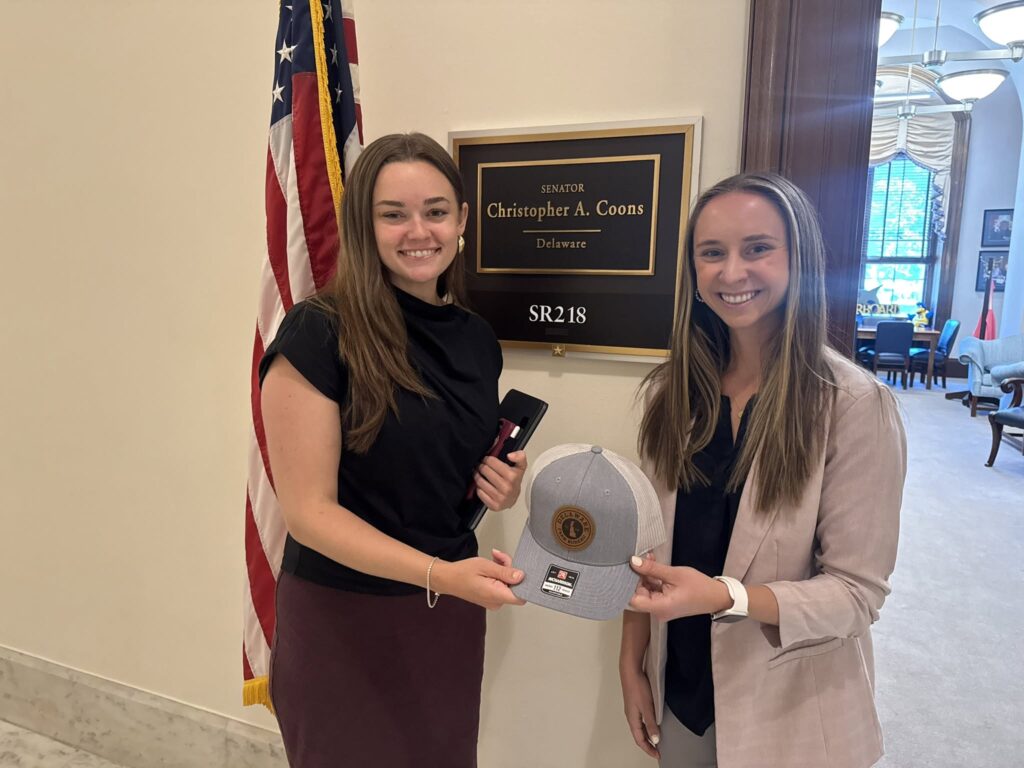
    Spot and croaker can be found in several lower Bay locations, including the Cobb Island area, the mouths of the Wicomico and St. Marys rivers, Cornfield Harbor in the lower Potomac, the mouth of the Patuxent, Tangier Sound, and the mouth of the Honga River. Most croaker are running slightly under the required 9-inch minimum. White perch occasionally mix in.

    Large red drum are providing exciting catch-and-release action near the Target Ship and Point Lookout areas, where anglers are jigging, trolling, and dropping soft crab baits. Cobia are also expected to be roaming these same areas this week.

    Blue Crabs

    Recreational crabbers are seeing fair to good catches in the middle and lower Bay this week. The best hauls are coming from the southern region on the eastern side of the Bay. Larger crabs are being found in 10 to 12 feet of water, while smaller crabs are showing up in shallower areas under 8 feet.

    Freshwater Fishing

    At Deep Creek Lake, smallmouth and largemouth bass are settling into their summer routines. Early morning finds them on main lake points and grass edges, while later in the day they seek shade under floating docks, fallen treetops, and submerged stumps. Bluegills are near docks, and trout are holding deep along the dam face.

    Trout fishing in the Group II Delayed Harvest areas has been good since those sections opened June 15. Sections of the North Branch of the Potomac, the Casselman, and the Youghiogheny are now open to trout harvest. Anglers should confirm which specific sections are open before fishing — details are available on the DNR website or on page 25 of the Maryland Fishing and Crabbing Guide.

    The upper Potomac is running low and clear. Long casts and light lines are essential. Smallmouth bass fishing is good with crawfish crankbaits and topwater lures in the early morning. Deeper-holding smallmouth and walleye can be targeted with ring worms, paddletails, and tubes.

    Water levels are low in central region reservoirs, but fishing for largemouth and smallmouth bass remains good. The best action is during early morning and late evening near grass beds and shoreline structure. Spinnerbaits, paddletails, poppers, and soft plastics are all productive choices. Largemouth bass are transitioning to a summer pattern, feeding mostly at night and in low-light conditions. Targeting floating grass mats with wacky-rigged stick worms, flipping under docks and fallen treetops, or working deep structure are all solid tactics. Chesapeake Channa (snakeheads) are holding in grass beds of the tidal rivers and can be targeted with frogs, buzzbaits, or chatterbaits.

    Atlantic Ocean and Coastal Bays

    Surf anglers near Ocean City are pulling in kingfish along with a mix of flounder, blowfish, and bluefish. Bloodworms and artificial bloodworm baits are the top choice for kingfish; squid works well for flounder and blowfish; and cut mullet or finger mullet is the go-to for bluefish.

    At the inlet and Route 50 Bridge area, striped bass are being caught during morning and evening hours near jetty rocks and bridge and dock piers. Soft plastic jigs and paddletails are popular lures. After dark, anglers are catching striped bass and bluefish by drifting cut bait. Sheepshead are being caught near the jetty rocks and bulkheads using sand fleas.

    Flounder fishing has been good in the channels leading from the inlet and in some back bay channel areas. Drifting in front of the airport is reported to be a productive spot for flounder. Striped bass are still being caught during early morning and late evening hours at the Verrazzano and Route 90 bridge piers, with soft plastic jigs and paddletails as the top lure choices.

    Black sea bass fishing remains solid at offshore wreck and reef sites. Flounder are also being found at those same locations and on shoals and lumps outside the inlet. At the canyon areas, the first white marlin release of the season has been reported, and some yellowfin tuna and golden tilefish have been brought to the docks.

    The Maryland Fishing Report is written and compiled by Keith Lockwood, a fisheries biologist with the Maryland Department of Natural Resources. The Forecast Summary is written by Tidewater Ecosystem Assessment Director Tom Parham. Maryland anglers are encouraged to participate in DNR’s Volunteer Angler Surveys to help scientists monitor and manage important fish species.