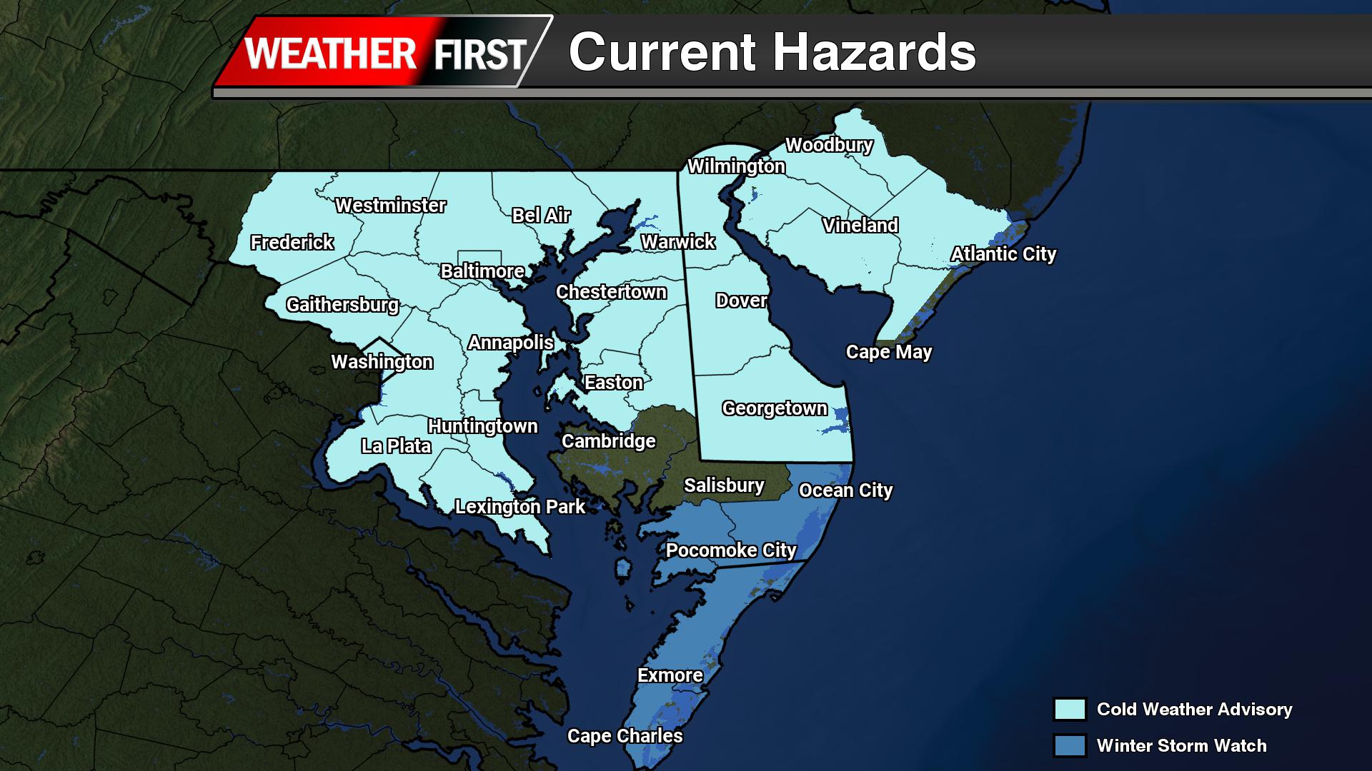
...WINTER STORM WATCH IN EFFECT FROM SATURDAY MORNING THROUGH SUNDAY
AFTERNOON...

* WHAT...Heavy snow possible. Total snow accumulations between 3 and
  5 inches possible. Winds could gust as high as 45 to 55 mph.

* WHERE...In Maryland, Inland Worcester, Maryland Beaches, and
  Somerset Counties. In Virginia, Accomack County.

* WHEN...From Saturday morning through Sunday afternoon.

* IMPACTS...Plan on slippery road conditions. Strong winds could
  cause tree damage.

PRECAUTIONARY/PREPAREDNESS ACTIONS...

Monitor the latest forecasts for updates on this situation.
Delaware State Police are actively searching for two armed suspects following a Tuesday evening robbery at a Dover tobacco store.
Authorities responded to the New York Smoke Shop at 3150 North Dupont Highway around 10:00 p.m. on January 27, 2026, after receiving reports of an armed robbery. According to investigators, two men wielding hatchets burst into the store and forced the employee to open the cash register. The pair grabbed money and several tobacco items before fleeing on foot.
Police describe both suspects as males dressed in dark clothing who concealed their identities with face masks and wore gloves during the crime.
The case remains under active investigation by the Delaware State Police Troop 3 Criminal Investigations Unit. Authorities are urging anyone with relevant information to reach out to Detective D. Adams at (302) 698-8442. Tips can also be submitted through private messages to the Delaware State Police Facebook page or by calling Delaware Crime Stoppers at 1-800-847-3333.
Crime victims and witnesses seeking support can access assistance around the clock through the Delaware State Police Victim Services Unit and Delaware Victim Center. Help is available by calling the 24-hour hotline at 1-800-VICTIM-1 (1-800-842-8461) or by emailing [email protected].
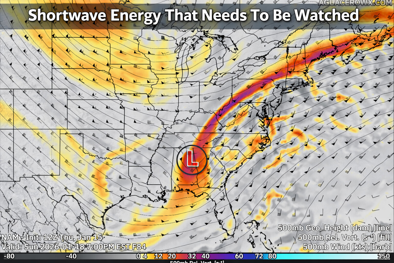
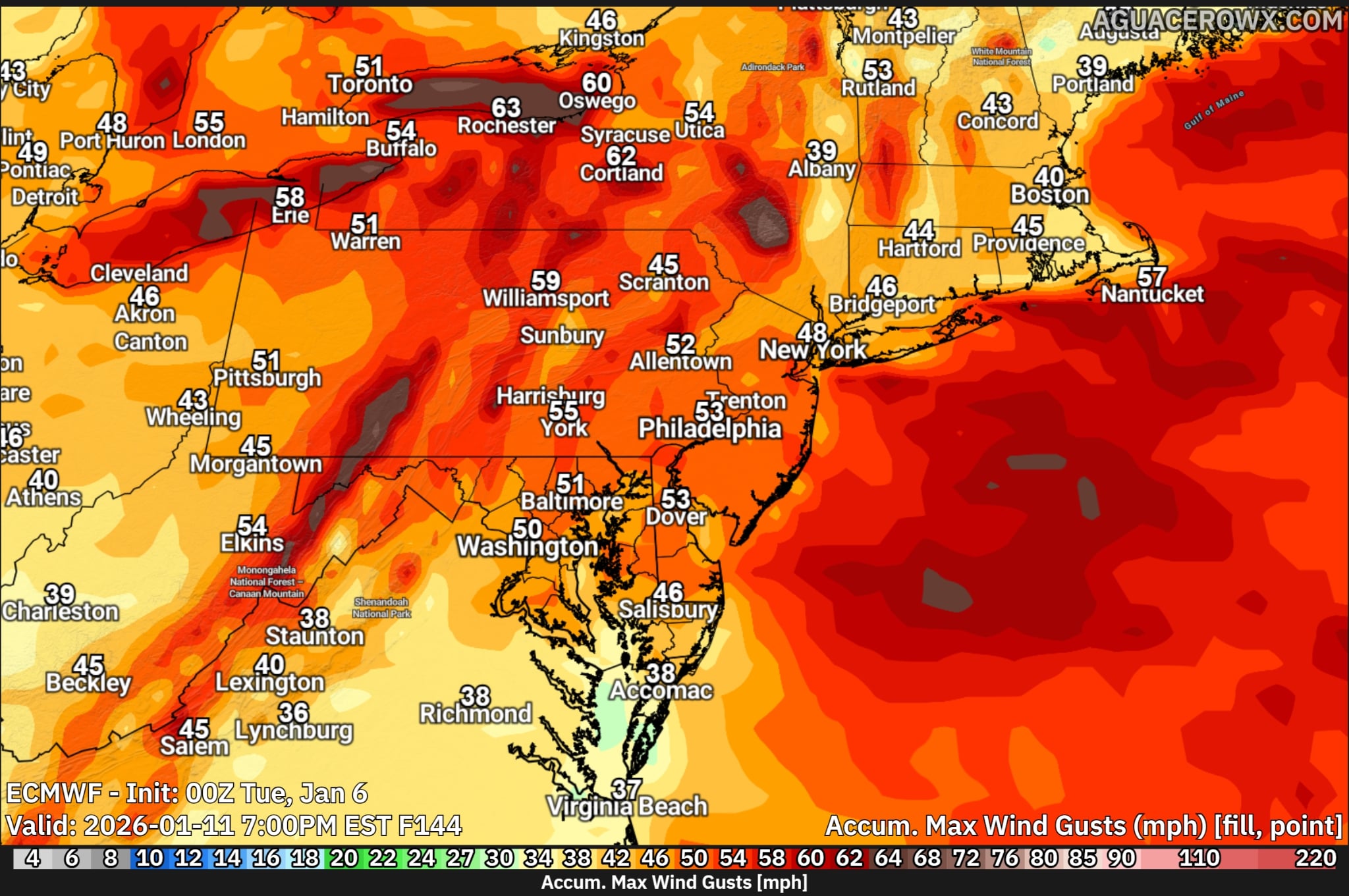
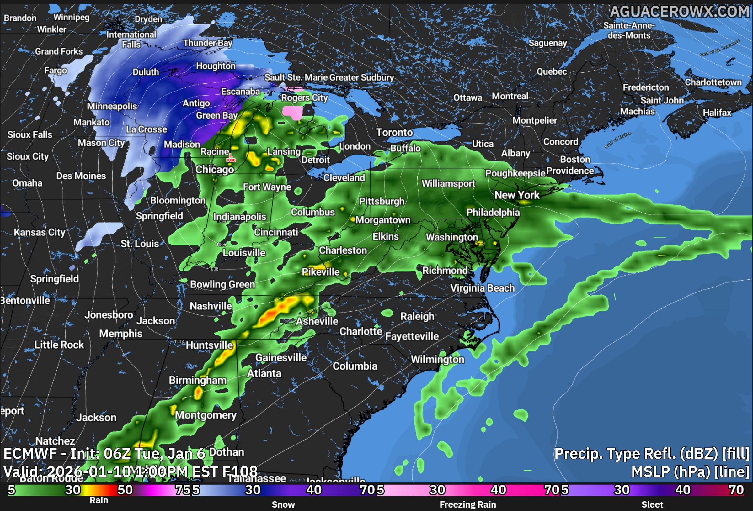
We are closely monitoring a rapidly strengthening coastal storm expected to develop off the East Coast this weekend. While confidence in the exact track and impacts remains low, the system has the potential to bring moderate to significant winter weather impacts to parts of the region, including snow, strong winds, and coastal flooding.
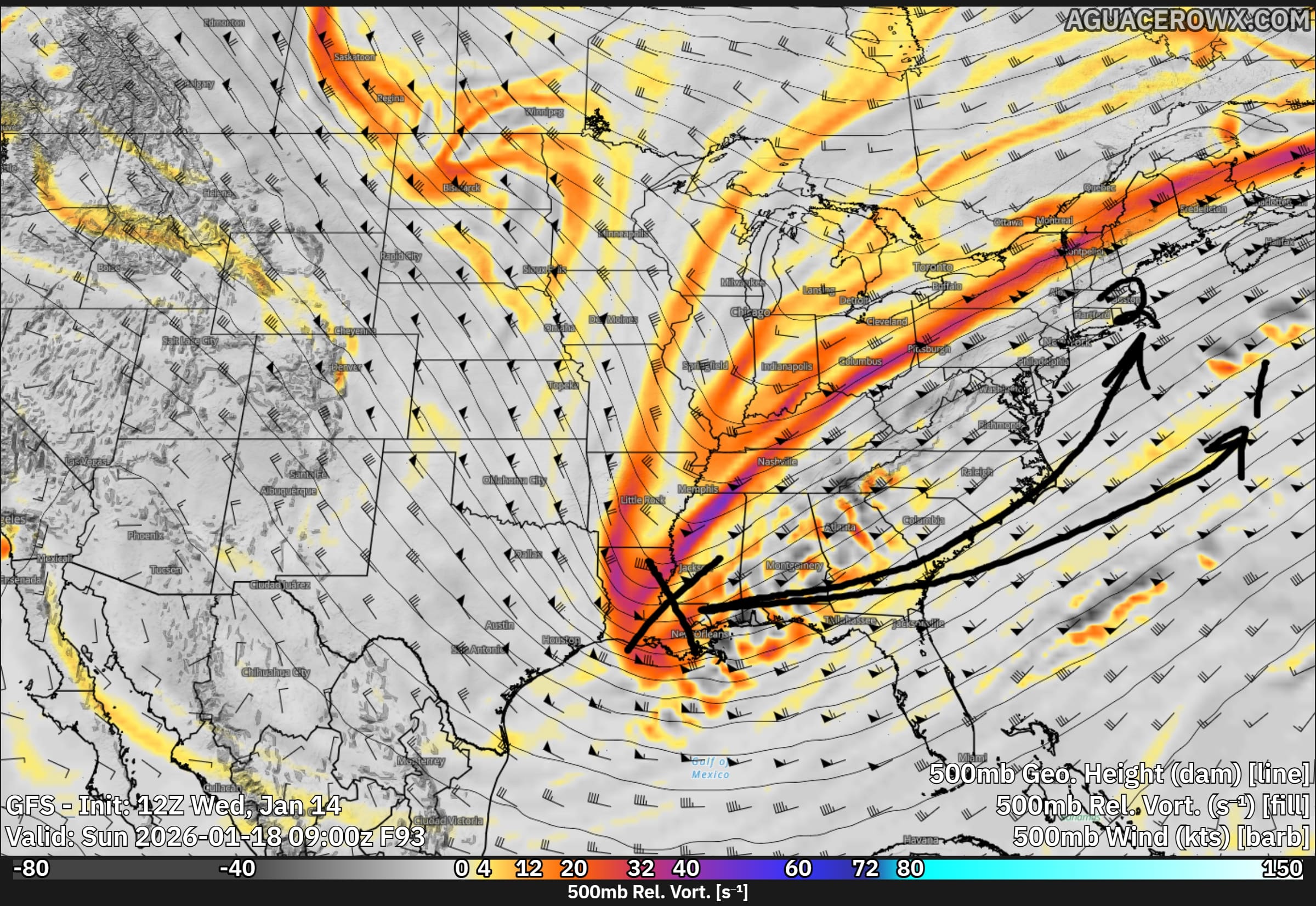
Forecast guidance continues to show low pressure rapidly developing off the southeastern U.S. coast on Saturday before intensifying and moving north and east Saturday night into Sunday. This storm will strengthen as a powerful upper level disturbance rotates around the base of a large-scale trough over the eastern United States and interacts with a strong temperature contrast along the coastline. This setup is favorable for rapid intensification, which could lead to high-impact weather depending on the storm’s eventual track.
One of the reasons forecast confidence remains limited is ongoing difficulty within some weather models in accurately handling the storm’s development. Several models are struggling with an issue known as convective feedback. This occurs when the model generates unrealistic high vertical velocities that are too strong or widespread, which in turn creates artificial areas of low pressure that should not exist. These false low pressure centers can disrupt the overall storm structure, leading to errors in the placement of the main low and causing the precipitation shield to appear displaced or unrealistic compared to what may actually occur.
As a result, small but important details such as where the heaviest snow sets up and how far inland precipitation reaches remain uncertain. This has contributed to notable spread among model solutions, particularly regarding how close the storm tracks to the coast.
If the storm tracks closer to shore, impacts could begin as early as late Saturday, with the most significant conditions occurring Saturday night into Sunday morning. With very cold air firmly in place at both the surface and aloft, any precipitation that reaches the region would almost certainly fall as snow.
Probabilistic snowfall data suggests a moderate risk for accumulating snow. The likelihood of at least 2 inches of snow is around 50 percent near the coast and roughly 40 percent along the I-95 corridor, with lower probabilities farther inland. The chance of 6 inches or more increases closer to the coast, reaching around 40 percent, while remaining near 30 percent around the urban corridor. These probabilities remain subject to change as confidence improves.
Regardless of snowfall totals, increasing winds appear likely. Northerly to northeasterly winds are expected to strengthen Saturday night into Sunday, with gusts of 25 to 35 mph inland and up to 50 mph along the coast. A closer track could result in even stronger winds, raising the risk for power outages, minor structural damage, and hazardous marine conditions. The strong wind field may also contribute to coastal flooding as water is pushed toward the shoreline.
By Sunday evening, the storm is expected to rapidly pull away to the northeast, with quieter but cold conditions settling in for early next week.
This storm remains one to watch closely over the coming days. Forecast details should become clearer as additional data is sampled and models better resolve the system. Residents are encouraged to stay informed and prepared for potential winter weather impacts this weekend.
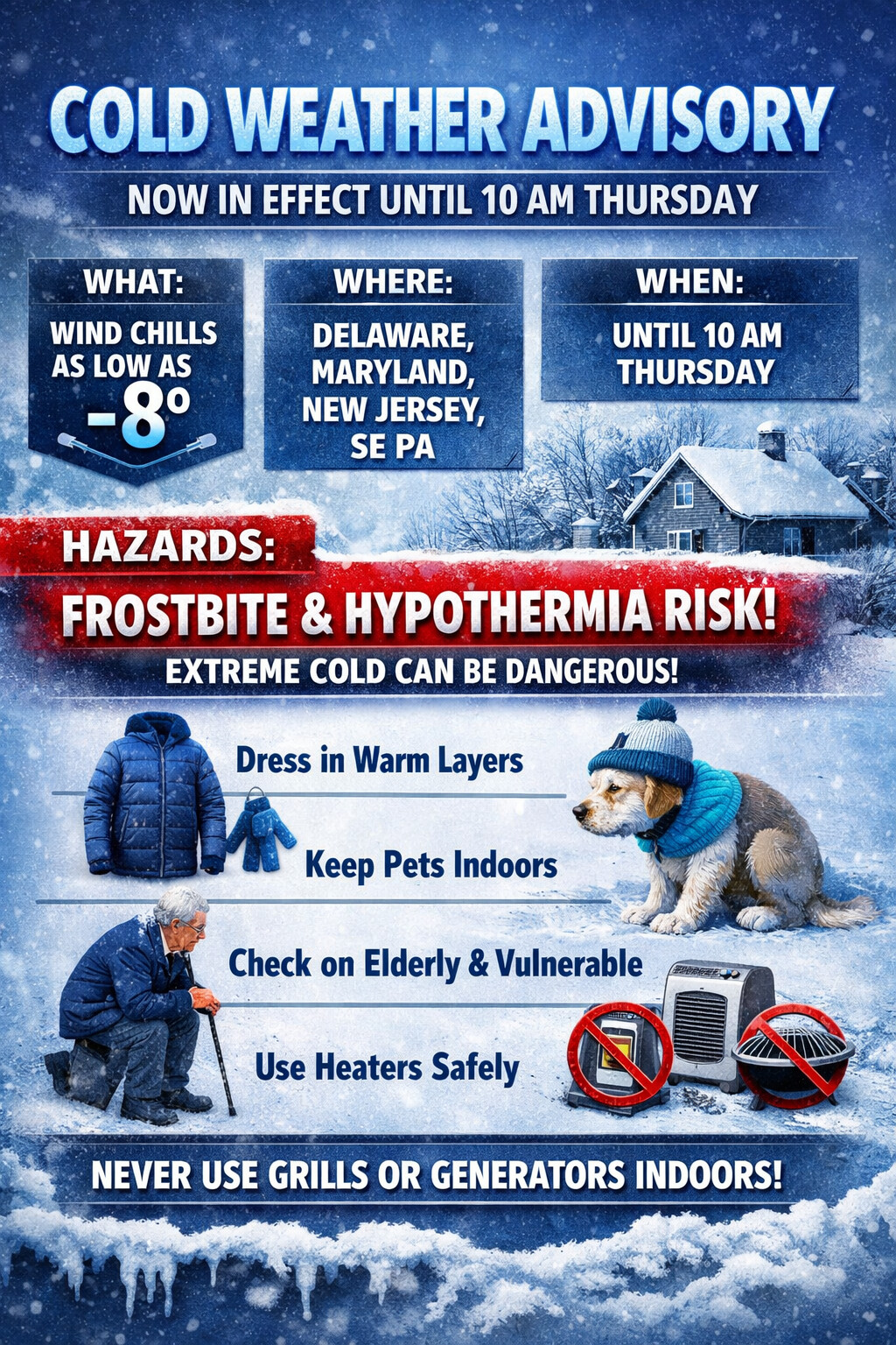
...COLD WEATHER ADVISORY NOW IN EFFECT UNTIL 10 AM EST THURSDAY...

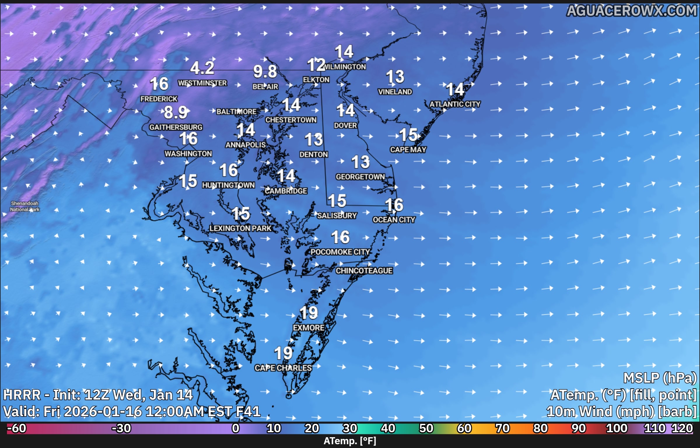
* WHAT...Very cold wind chills as low as 8 below.

* WHERE...Portions of central, northern, and southern Delaware,
  northeast Maryland, central and southern New Jersey, and southeast
  Pennsylvania.

* WHEN...Until 10 AM EST Thursday.

* IMPACTS...The cold wind chills as low as 10 below zero could
  result in hypothermia if precautions are not taken. Frostbite and
  hypothermia will occur if unprotected skin is exposed to these
  temperatures.

PRECAUTIONARY/PREPAREDNESS ACTIONS...

Use caution while traveling outside. Wear appropriate clothing, a
hat, and gloves.

Keep pets indoors as much as possible.

Make frequent checks on older family, friends, and neighbors. Ensure
portable heaters are used correctly. Do not use generators or grills
inside.
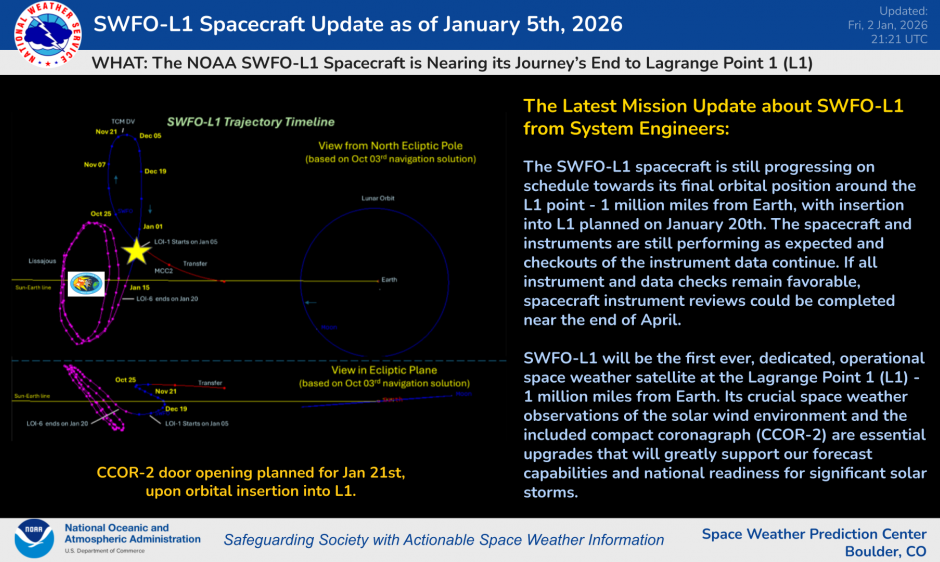
A major milestone in space weather monitoring was reached this week as NOAA’s Space Weather Follow On-Lagrange 1 (SWFO-L1) observatory successfully executed its final engine burn and entered its intended orbit at the Sun-Earth Lagrange point 1, roughly one million miles from Earth. At this unique vantage point, the satellite will be able to continuously observe the sun and space weather conditions before they reach our planet.
With its arrival at this critical location on January 23, the observatory has officially been renamed Space weather Observations at L1 to Advance Readiness – 1 (SOLAR-1). This marks a significant step forward in operational space weather forecasting for NOAA.
Greg Marlow, Director of NOAA’s Office of Space Weather Observations, highlighted the importance of the mission, saying, “SOLAR-1, America’s first satellite designed exclusively for continuous, operational space weather observations, represents a major advancement in our defense against solar storms.”
SOLAR-1 will provide state-of-the-art data to forecasters and other users, improving the timeliness and accuracy of space weather forecasts, warnings and alerts. Richard Ullman, Deputy Director of NOAA’s Office of Space Weather Observations, emphasized that the data will help protect critical missions and infrastructure, including support for NASA’s Artemis lunar exploration program.
“This spacecraft is going to be an impressive new tool… because space weather is a global concern,” said Shawn Dahl, Service Coordinator at NOAA’s Space Weather Prediction Center. Dahl noted that space weather events can have wide-ranging impacts, from affecting critical systems on Earth to space-based infrastructure.
SOLAR-1 will undergo additional checkout and instrument validation before beginning operational service in Spring 2026. Once fully commissioned, the observatory is expected to deliver continuous real-time observations of the solar wind and other space weather phenomena that can disrupt communications, navigation systems and power infrastructure here on Earth.
The satellite was launched on September 24, 2025, aboard a SpaceX Falcon 9 rocket from NASA’s Kennedy Space Center in Florida, marking the start of its journey to its final orbit.
We are closely monitoring the potential for a coastal storm to develop near the Mid-Atlantic next weekend. While confidence remains low regarding exact impacts, there is growing concern that the storm could track close enough to bring at least some impacts to portions of the region.
Latest forecast guidance, including both deterministic and ensemble models, continues to signal the development of a system off the Mid-Atlantic coast. Recent model trends suggest a scenario in which the storm tracks close to the coastline, potentially scraping coastal areas. Under this setup, locations along the immediate coast and across Delmarva would be most vulnerable, while areas farther inland such as the Poconos and nearby higher elevations could see little to no impact.
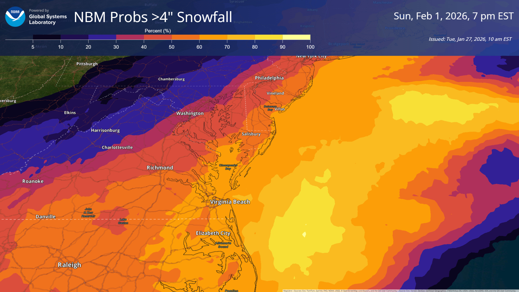
Current probabilistic snowfall guidance highlights this coastal focus. The latest National Blend of Models indicates a 20 to 25 percent chance of more than 4 inches of snow across northern and western zones. Probabilities increase to around 40 percent along the I-95 corridor and climb to near 50 percent along the immediate coast. These probabilities remain subject to change as the storm track becomes better defined in the coming days.
If the storm does impact the region, timing would favor a late Saturday arrival, with effects potentially lingering through Sunday. In addition to snowfall, strong winds may accompany the system. Even if the storm’s center remains offshore, coastal areas could still experience gusty conditions capable of producing hazardous travel and marine impacts.
One factor that is not in question is the presence of a cold airmass. Temperatures are expected to remain well below normal through next weekend and into early next week. This cold setup would be more than sufficient to support snow at the onset of the storm, should it materialize.
At this time, the forecast remains highly uncertain, and residents are encouraged to stay informed as newer data becomes available. Small changes in storm track could result in large differences in impacts, especially across coastal and near-coastal areas. Updates will continue as confidence increases over the next several days.
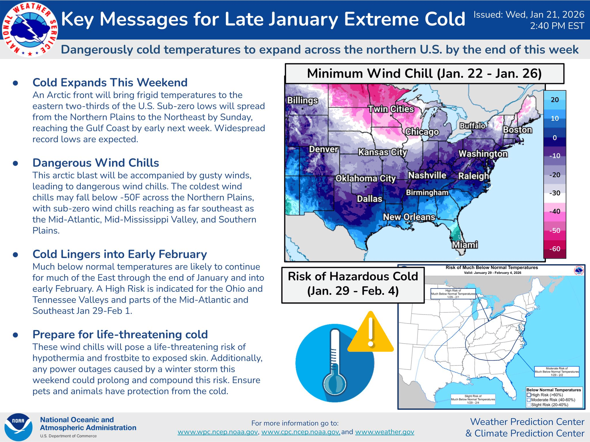
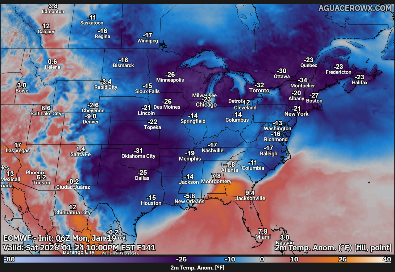
A prolonged and dangerous stretch of arctic cold is firmly in place across much of the eastern United States and is expected to continue into early February, according to the latest outlook from the Weather Prediction Center and Climate Prediction Center.
The cold air mass has already delivered record and near-record low temperatures across large portions of the South and Midwest in the wake of a recent winter storm. Overnight lows have plunged into the single digits and below zero in many areas, creating life-threatening conditions, especially for those still dealing with power outages or inadequate heating.
Wind chills are compounding the danger. In parts of the Ohio Valley, wind chills are forecast to drop into the minus 20s, posing a serious risk of frostbite and hypothermia even with limited exposure. Officials urge residents to limit time outdoors, dress in multiple layers, and ensure pets and livestock have adequate shelter from the cold. Frozen pipes also remain a major concern as temperatures stay well below freezing for extended periods.
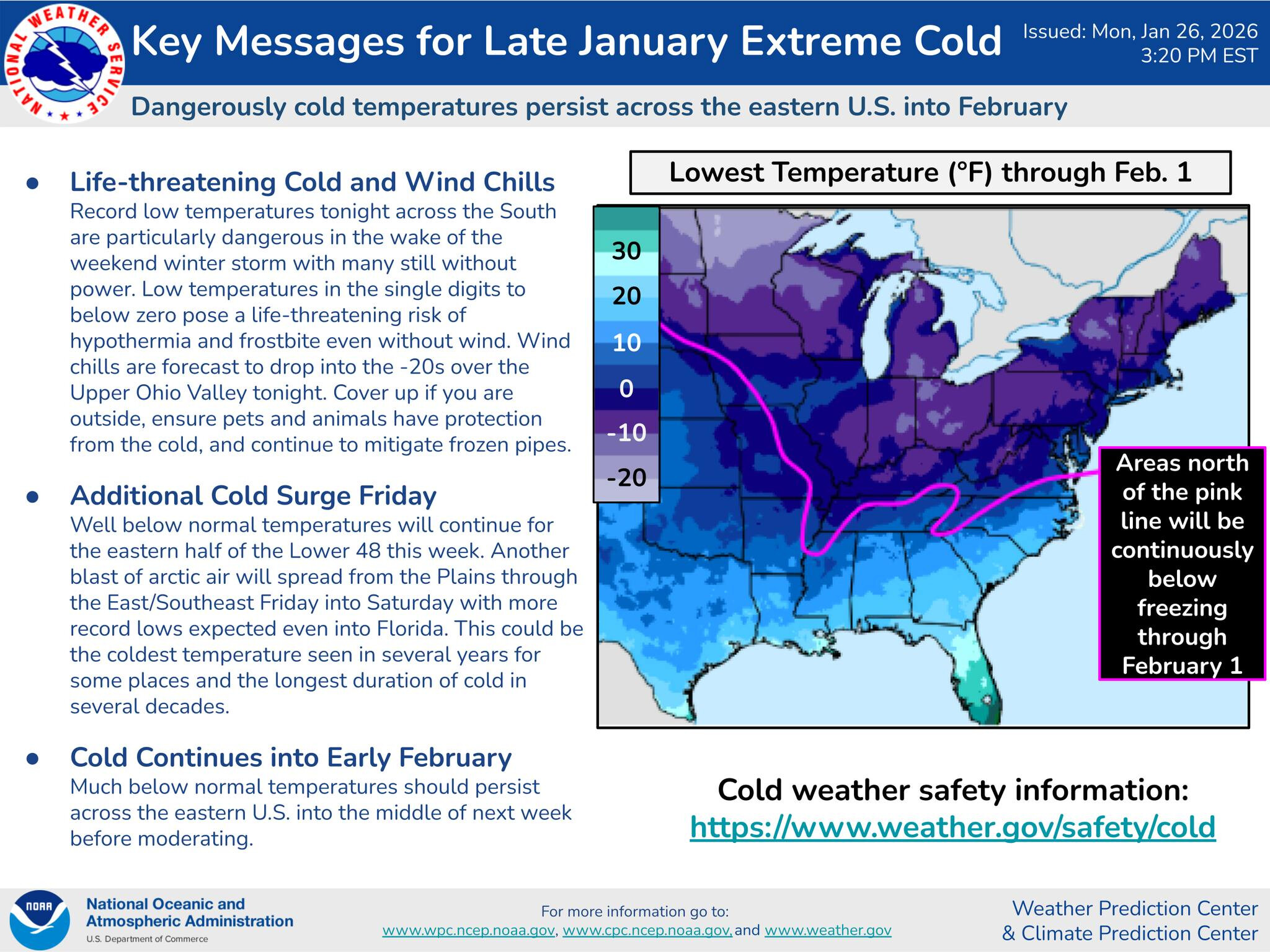
The accompanying temperature outlook map shows that areas north of the highlighted pink line are expected to remain continuously below freezing through at least February 1. This includes much of the Midwest, Great Lakes, Northeast, and interior Mid-Atlantic, where daytime highs may struggle to rise above the teens and 20s.
Relief will be limited, as another surge of arctic air is expected to move southward late this week. Forecast guidance indicates a renewed blast of bitter cold spreading from the Plains into the East and Southeast Friday into Saturday. This surge could bring additional record low temperatures, potentially reaching as far south as Florida, and may mark the coldest conditions seen in several years for some locations.
Forecasters also warn that this could become one of the longest-lasting cold stretches in decades for parts of the eastern half of the country. Much below normal temperatures are expected to persist into the middle of next week before a gradual moderation begins.
With the extended duration of the cold, residents are encouraged to take ongoing precautions. This includes checking on vulnerable neighbors, using space heaters safely, keeping a slow drip on indoor plumbing, and having emergency supplies readily available.
Governor Matthew Meyer has officially ended the State of Emergency that was declared in response to the recent winter storm, effective 3 p.m. on Monday, January 26, 2026. The order, which was first issued Friday, January 23 and took effect in the early hours of Sunday, January 25, also releases the Delaware National Guard from active storm response duties.
Although the formal emergency declaration has concluded, Level 1 driving warnings remain in effect for New Castle and Kent Counties, meaning drivers are strongly advised to avoid travel unless it is necessary for health, safety, or critical business reasons. All motorists should continue to exercise extreme caution on roadways.
State and local crews are continuing cleanup operations, particularly on secondary roads where hazardous conditions may persist as ice melts and temperatures remain below freezing. The National Weather Service has issued a cold weather advisory that is expected to remain in place through Wednesday, January 28, as sub-freezing temperatures continue across the region.
In announcing the end of the state of emergency, Governor Meyer thanked residents for their cooperation during the storm.
“I am grateful that Delaware residents helped weather this winter storm by being prepared, staying informed and by remaining at home, allowing emergency crews to clear the roads and respond to calls for assistance,” Meyer said. He urged continued caution, especially while road conditions improve and winter weather impacts linger.
Residents who have not already done so are encouraged to sign up for emergency alerts through the Delaware Emergency Notification System (DENS) and visit PrepareDE.org for guidance on winter weather readiness.
The Delaware Emergency Management Agency (DEMA) continues leading coordination efforts for storm response and community safety. DEMA works with state and local partners to support preparedness, response, and recovery efforts during weather-related and other emergencies.
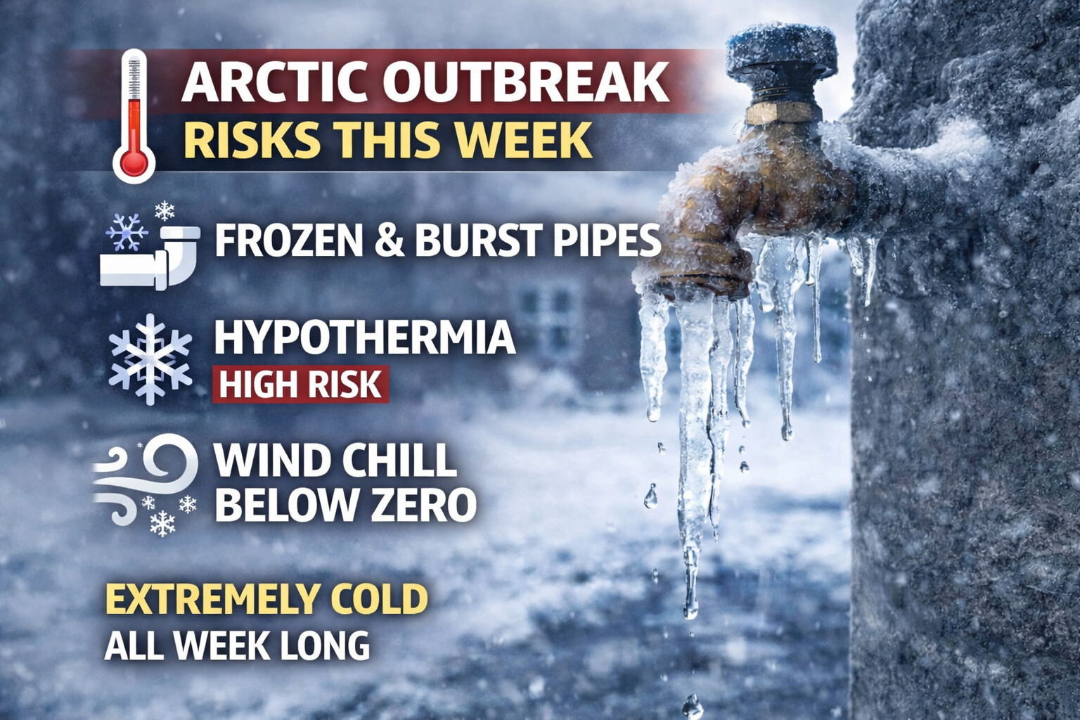
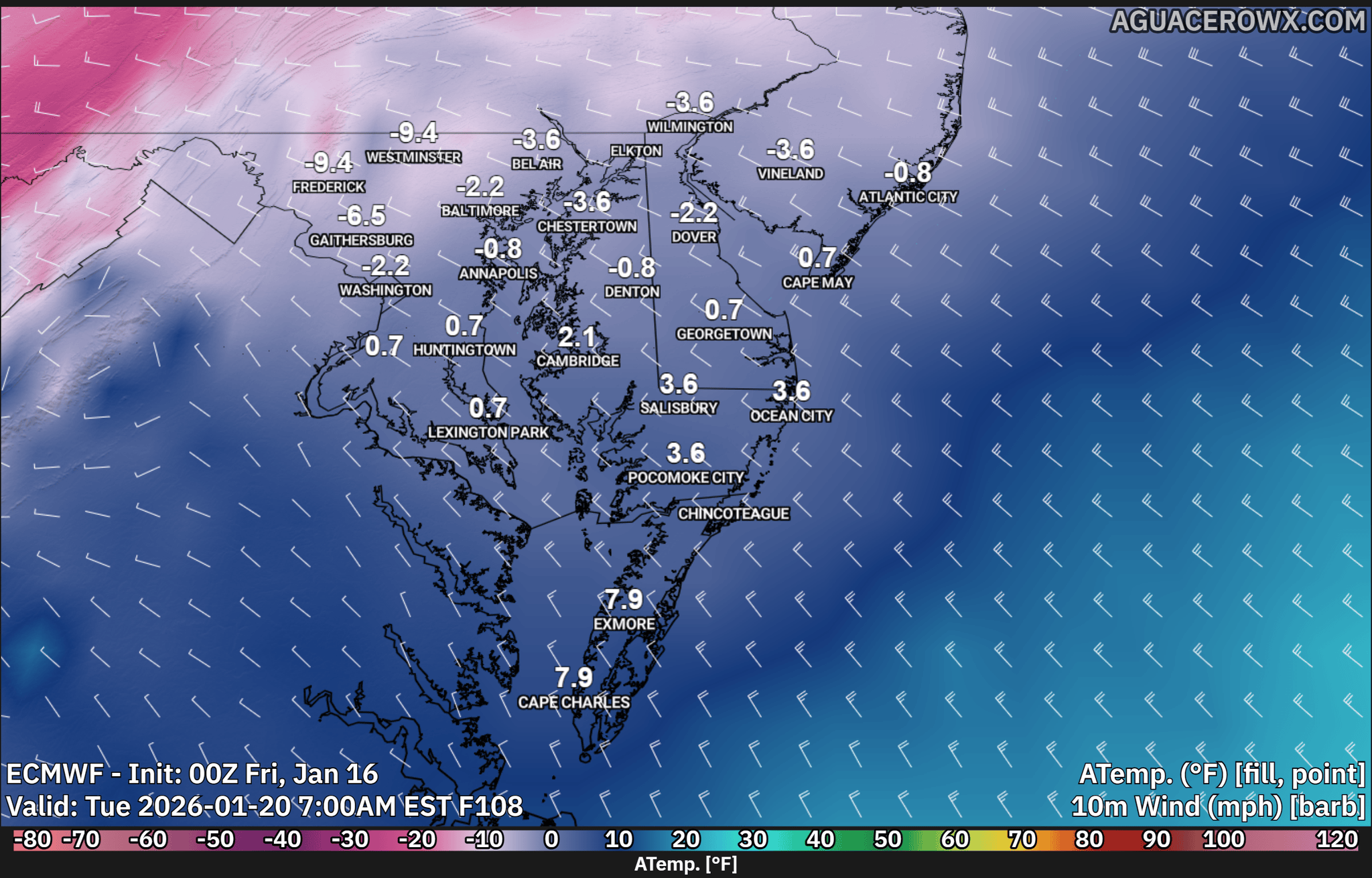
An extended period of dangerously cold weather is expected this week, with overnight low temperatures dropping into the single digits and wind chills falling below zero for several nights. These conditions increase the risk of frozen pipes, hypothermia, and other cold related hazards across the region.
Residents are urged to take precautions now, as the prolonged nature of the cold makes this event particularly concerning. When temperatures remain below freezing for extended periods, water inside pipes can freeze, expand, and cause pipes to crack or burst, leading to significant water damage.
To reduce the risk of frozen pipes, homeowners should allow faucets to drip slightly, especially those connected to exterior walls. Opening cabinet doors beneath sinks can help warmer air circulate around plumbing. Pipes in unheated areas such as basements, crawl spaces, garages, and exterior walls should be insulated if possible. If leaving home, indoor temperatures should be kept no lower than 55 degrees.
Knowing where your main water shutoff valve is located can help limit damage if a pipe bursts. If a frozen pipe is suspected, keep the faucet open and apply gentle heat using a hair dryer or warm towels. Open flames should never be used to thaw pipes.
The extreme cold also poses a serious threat to personal safety. With wind chills expected to remain below zero at times throughout the week, the risk of hypothermia increases significantly. Hypothermia occurs when the body loses heat faster than it can produce it, causing body temperature to drop to dangerous levels.
Symptoms of hypothermia include intense shivering, confusion, slurred speech, drowsiness, and loss of coordination. Anyone experiencing these symptoms should seek medical attention immediately. Limiting time outdoors, wearing multiple layers, and covering exposed skin are critical during this cold stretch. Hats, gloves, scarves, and insulated footwear can greatly reduce heat loss.
Space heaters should be used with caution. Keep them at least three feet away from flammable materials and never leave them unattended. Carbon monoxide and smoke detectors should be checked to ensure they are working properly, especially when using supplemental heat sources.
Pet safety is also a concern during this cold outbreak. Pets should be brought indoors whenever possible. Outdoor animals must have adequate shelter, unfrozen water, and extra food to maintain body heat.
With bitter cold expected to persist all week, preparation and awareness are essential. Taking steps now can help prevent costly damage to homes and reduce the risk of serious cold related illnesses.
Residents are encouraged to continue monitoring forecasts and any cold weather advisories or warnings that may be issued as conditions evolve.
...Kent County... Dover 6.5 in 0910 AM 01/25 Public Dover Air Force Base 6.5 in 1155 AM 01/25 AWOS Woodside 6.3 in 0300 PM 01/25 Trained Spotter Smyrna 6.0 in 0938 AM 01/25 Trained Spotter Camden 6.0 in 1138 AM 01/25 Trained Spotter Magnolia 5.6 in 0100 PM 01/25 Trained Spotter Dover 5.5 in 1100 AM 01/25 Public Harrington 2 ENE 5.5 in 0830 AM 01/26 COCORAHS
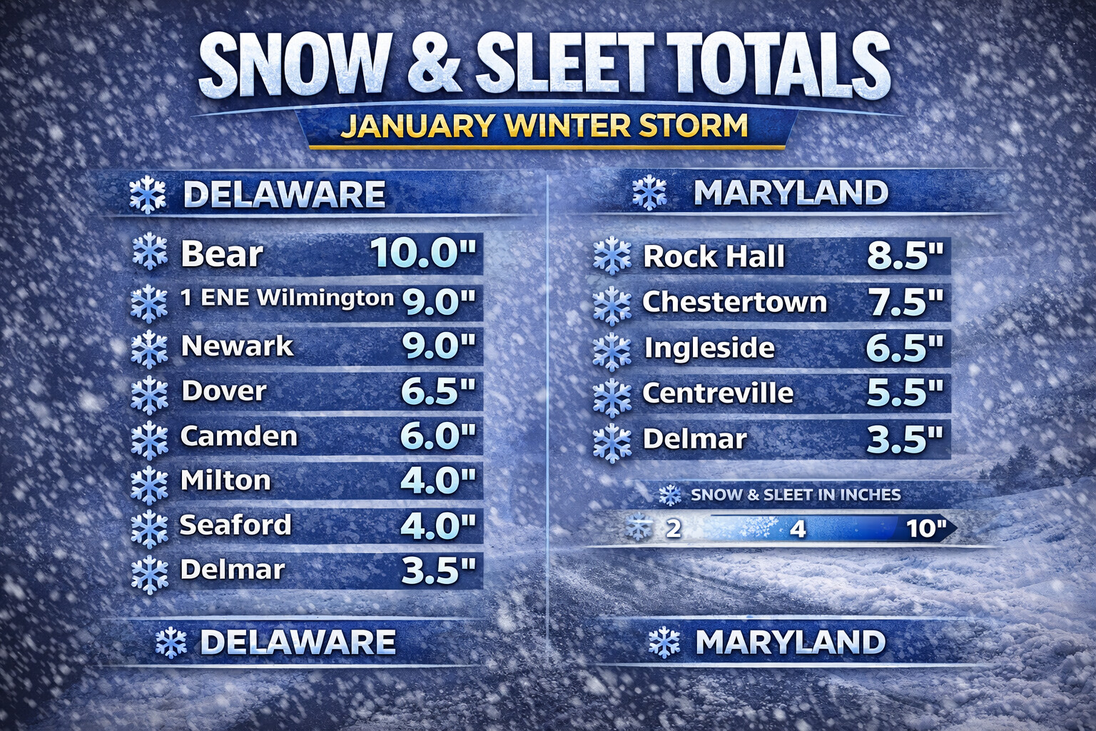
...New Castle County... Bear 10.0 in 1100 PM 01/25 Public 1 ENE Wilmington 9.0 in 0800 PM 01/25 Public Newark 1.5 S 9.0 in 0730 AM 01/26 COCORAHS 1 NE Holiday Hills 8.7 in 0900 PM 01/25 Trained Spotter Pike Creek 8.5 in 1000 PM 01/25 Trained Spotter New Castle County Airport 8.3 in 1200 AM 01/26 ASOS Twin Oaks 8.1 in 0800 PM 01/25 Trained Spotter 1 E Talleyville 8.0 in 0315 PM 01/25 Public New Castle 8.0 in 0646 PM 01/25 Public Hockessin 7.8 in 1015 PM 01/25 Trained Spotter Newark 7.5 in 0600 PM 01/25 Trained Spotter Hockessin 6.5 in 1020 AM 01/25 Public Wilmington 6.5 in 1120 AM 01/25 Trained Spotter Odessa 6.5 in 1230 PM 01/25 Trained Spotter 1 SW Middletown 6.0 in 1030 AM 01/25 Public
...Sussex County... 3 ESE Bridgeville 4.5 in 0800 AM 01/26 COCORAHS Milton 4.0 in 0800 AM 01/25 Broadcast Media Selbyville 4.0 in 0839 AM 01/25 Trained Spotter Seaford 4.0 in 0700 AM 01/26 COCORAHS Ellendale 3.4 ENE 3.7 in 0700 AM 01/26 COCORAHS Dagsboro 6.3 E 3.7 in 0715 AM 01/26 COCORAHS Milton 3.5 in 1130 AM 01/25 Public Milton 3.0 E 3.0 in 0700 AM 01/26 COCORAHS Lewes 3.9 SW 3.0 in 0942 AM 01/26 COCORAHS Dagsboro 7.1 ENE 2.9 in 0700 AM 01/26 COCORAHS Delmar 4.3 E 2.0 in 0700 AM 01/26 COCORAHS Delmar 0.1 WSW 2.0 in 0731 AM 01/26 COCORAHS Georgetown 1.5 in 0615 AM 01/25 Amateur Radio 1 WNW Seaford 1.5 in 0615 AM 01/25 Amateur Radio Millsboro 1.3 W 1.5 in 0700 AM 01/26 COCORAHS
...Maryland...
...Kent County... Rock Hall 8.5 in 0400 PM 01/25 Trained Spotter Chestertown 7.5 in 0820 PM 01/25 Trained Spotter
...Queen Annes County... Ingleside 6.5 in 1030 AM 01/25 Trained Spotter Barclay 5.5 in 0820 AM 01/25 Broadcast Media Centreville 5.5 in 0912 AM 01/25 Emergency Mngr Sudlersville 5.0 in 0851 AM 01/25 Emergency Mngr Queenstown 2.6 S 4.0 in 0800 AM 01/26 COCORAHS Church Hill 3.5 in 0810 AM 01/25 Emergency Mngr Grasonville 3.0 in 0720 AM 01/25 Emergency Mngr
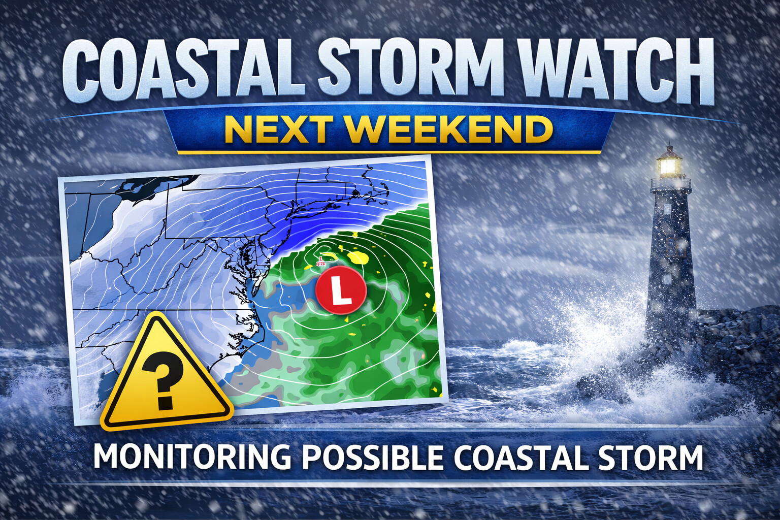
Forecast models are signaling the potential for a coastal storm to develop near the Mid-Atlantic next weekend, though confidence remains low at this time regarding whether a system will actually form and what impacts it could bring to Delmarva.
Both deterministic and ensemble guidance continue to suggest that some type of storm system may attempt to organize off the Mid-Atlantic coast during the weekend. However, overnight model runs remain inconsistent, showing a wide range of possible outcomes. While there is general agreement that a disturbance could develop, there is little agreement on the track, strength, or impacts of the system.
The ECMWF and its AI-based guidance are currently the most bullish, indicating a more organized coastal system. In contrast, the GFS and CMC models favor scenarios that either miss the region entirely or produce only minor impacts. This spread highlights the uncertainty that still exists several days out.
Probabilistic guidance also reflects the low confidence. The EPS ensemble shows only a 20 to 35 percent chance of at least four inches of snow in a 24 hour period across the region, with similar probabilities indicated by the National Blend of Models. These values suggest that while snow is possible, the risk of a significant snowfall remains limited at this stage.
One factor that is more certain is the cold air mass that will be in place. Below normal temperatures are expected to persist into next weekend, meaning that any precipitation associated with a storm would likely fall as snow, provided a system tracks close enough to impact Delmarva.
At this point, the forecast hinges on whether a storm develops at all and where it ultimately tracks. These details are expected to become clearer over the coming days as models better resolve atmospheric features following the recent storm system.
Residents across Delmarva are encouraged to stay informed and monitor forecast updates, especially given the cold conditions that will already be in place. While it is too early to pin down specific impacts, this is a system worth watching as the weekend approaches.
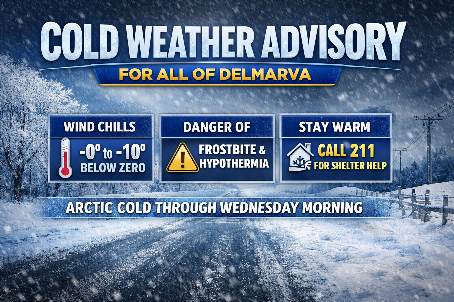
A Cold Weather Advisory is now in effect for all of Delmarva as an arctic air mass settles across the region, bringing dangerously cold wind chills through Wednesday morning.
The advisory is in effect from 7 p.m. this evening through 10 a.m. Wednesday, with the coldest conditions expected overnight and during the early morning hours. Wind chills across Delmarva are forecast to fall between 0 and 10 degrees below zero, creating hazardous conditions for anyone exposed to the cold for extended periods.
These bitterly cold wind chills can quickly lead to hypothermia or frostbite if proper precautions are not taken. Even brief exposure without adequate protection can become dangerous, especially during the overnight hours when temperatures and wind chills reach their lowest values.
Residents are urged to limit time outdoors, dress in multiple layers, and wear a hat and gloves when outside. Extra care should be taken for vulnerable populations, including children, the elderly, and pets. Outdoor pets should be brought indoors, and livestock should have access to adequate shelter and water that is not frozen.
Those who do not have reliable heat in their homes or lack proper shelter are encouraged to seek assistance. Dial 211 to find warming centers or emergency shelter options available in your area.
Looking ahead, additional cold weather headlines are likely. Forecast confidence continues to increase that the Cold Weather Advisory may be extended and could be upgraded to an Extreme Cold Warning for Wednesday night and possibly Thursday night. Wind chills below zero are expected to continue during nighttime hours into the weekend, keeping dangerous cold conditions in place across Delmarva.
Residents should continue to monitor the forecast closely and prepare now for an extended stretch of dangerous cold.
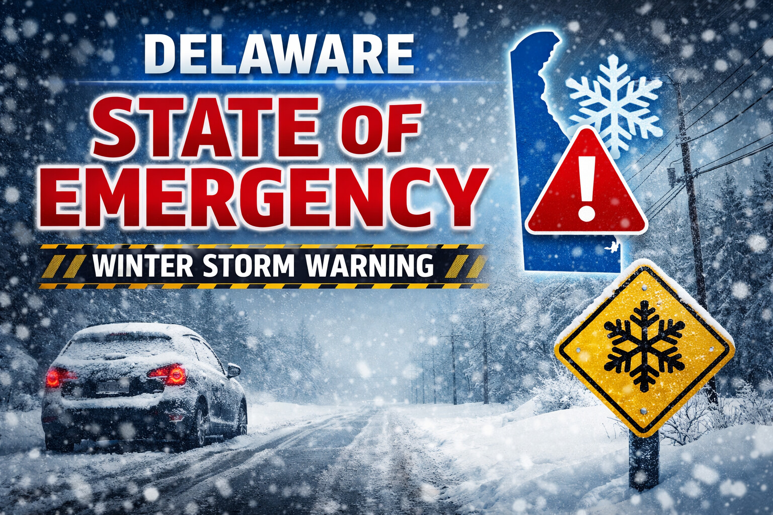
The State of Delaware has issued a Level 1 Driving Warning for all counties beginning at 12:01 a.m. on Sunday, aligning with the ongoing State of Emergency activated in response to the approaching winter storm. The warning will remain in effect until further notice and may be escalated if conditions deteriorate.
Governor Matthew Meyer and state officials say the warning is intended to protect residents and emergency personnel by minimizing nonessential travel while hazardous conditions develop across the region.
What the Level 1 Driving Warning Means
Under this advisory:
Drivers must exercise extra caution if they choose to operate a vehicle.
Motorists are strongly encouraged to stay off the roads unless travel is necessary for safety, health, or essential business reasons.
The warning reflects the dangerous conditions expected from the winter storm, which includes accumulating snow, ice, and slick road surfaces. This advisory is designed to help keep roads clear for plow operators, first responders, and other essential travel during the worst of the storm.
Safety Resources and Assistance
Delawareans in need of help during the storm are urged to call 211 for critical resources, including:
Shelter options
Food assistance
Transportation support for essential medical needs
Shelters Open Across the State
State officials also confirmed that Code Purple shelters are open 24 hours statewide in response to the severe winter weather. These shelters provide a warm, safe refuge for vulnerable residents, including meals and additional support services.
Contacts for shelter services include:
New Castle County: 302-652-8033
Kent County: 1-800-733-6816
Sussex County: 302-519-0024
Why Travel Restrictions Matter
Winter weather systems like this one pose a significant risk for motorists, especially when snow and ice accumulate on untreated road surfaces. Roads can become dangerously slippery, leading to increased crashes and response delays. By reducing nonessential travel, officials aim to:
Reduce crashes and roadside emergencies
Allow crews to clear and treat roads more efficiently
Keep emergency responders available for those who truly need help
State transportation crews and plow operators are already working to pre-treat major routes, but officials remind drivers that conditions can change rapidly and secondary roads may remain hazardous for longer.
Stay Updated
Residents should continue to monitor official state updates for the latest advisories and safety guidance as the storm progresses. Following weather alerts from the National Weather Service and alerts from state agencies will help keep communities safe throughout the event.
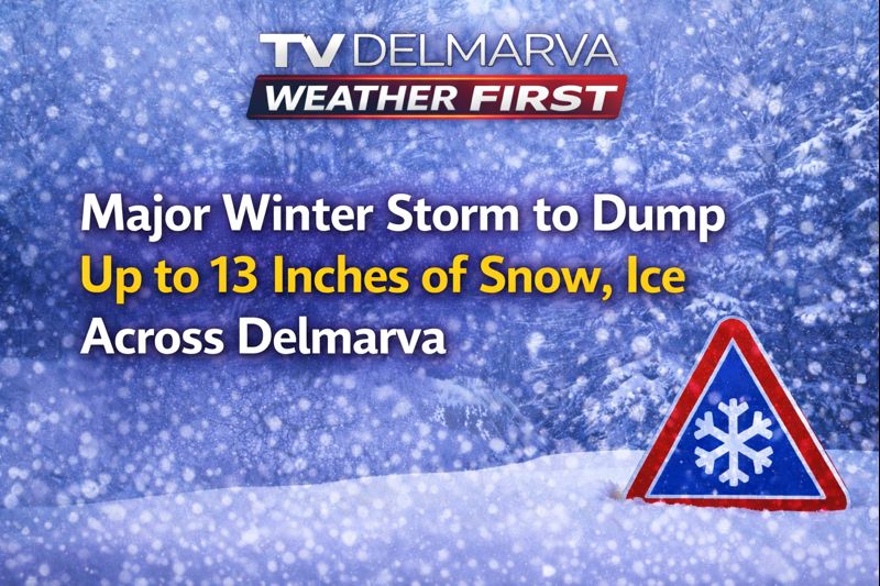
A dangerous winter storm is barreling toward the Delmarva Peninsula, prompting the National Weather Service to issue a Winter Storm Warning from 7 PM tonight through 1 PM Monday.
The storm is expected to bring 7 to 13 inches of heavy snow and sleet, along with up to three-tenths of an inch of ice accumulation across central and northern Delaware, northeast Maryland, and portions of New Jersey and Pennsylvania.
“Travel could be nearly impossible,” warns the National Weather Service. Ice buildup on power lines and tree limbs may cause widespread power outages and tree damage throughout the region.
Locally, New Castle and Kent counties in Delaware, along with Queen Anne’s, Talbot, and Caroline counties on Maryland’s Eastern Shore, are all under the warning. The hazardous conditions are expected to severely impact Monday morning’s commute.
Officials strongly advise residents to avoid unnecessary travel. If you must drive, keep emergency supplies including a flashlight, food, and water in your vehicle. For the latest road conditions, dial 511.
The Winter Storm Warning remains in effect until 1 PM Monday. TV Delmarva will continue monitoring conditions and providing updates throughout the storm.
The State of Delaware has declared a State of Emergency as a powerful winter storm approaches the region, mobilizing state and local agencies to prepare for potentially hazardous conditions. In response, the Delaware Emergency Management Agency (DEMA) has activated the Emergency Operations Center (EOC) to coordinate preparations and response efforts across the state.
Governor Matt Meyer emphasized the importance of readiness as this system moves in, saying that Delawareans should feel secure and well supported as severe winter weather conditions develop.
What the Declaration Means
A State of Emergency gives state leaders the authority to streamline decision-making and resource deployment, improve coordination with local governments and emergency responders, and position personnel and equipment strategically ahead of the storm. The EOC activation brings key agencies together to share data, track impacts in real time, and ensure rapid communication on public safety actions.
Expected Weather and Conditions
Forecasters are tracking a strong winter system expected to bring heavy snow, a wintry mix, and significant icing across much of Delaware. Snow totals could reach near a foot in some areas, with the exact amounts depending on storm track and temperature changes. After the storm’s passage, temperatures are projected to plunge into the teens and low 20s, increasing the risk of slick conditions and prolonged cold.
This system is part of a larger winter storm affecting the Mid-Atlantic and Northeast, with similar emergency declarations and warnings issued in neighboring states as snow and ice threaten travel and infrastructure.
Preparedness Actions Urged for Residents
Officials are urging Delaware residents to take proactive steps now to prepare for potential disruptions:
Stock up on essential supplies like non-perishable food, water, prescription medicines, and pet needs.
Prepare your home for extended cold by checking heating systems, weatherproofing doors and windows, and ensuring fuel supplies are adequate.
Assemble emergency kits for vehicles and households with flashlights, batteries, blankets, first-aid kits, and a battery-powered weather radio.
Avoid nonessential travel when conditions worsen. If travel is necessary, leave extra time, go slowly, and carry emergency gear in your vehicle.
DEMA also reminds residents to dress appropriately outdoors in layers and take measures to prevent cold-related health issues like hypothermia and frostbite.
What to Watch For
Officials warn that travel could become dangerous or impossible at times during the storm, particularly on Sunday and into early next week. Power outages and hazardous road conditions are possible, especially where heavier snow and ice accumulate.
State and local partners will continue monitoring conditions, issuing updates through emergency alerts, social media, and official channels. Residents should stay tuned to local forecasts and guidance from DEMA, the National Weather Service, and transportation authorities.
..WINTER STORM WARNING IN EFFECT FROM 7 PM SATURDAY TO 1 PM EST
MONDAY...

* WHAT...Heavy snow and mixed precipitation expected. Total snow
  accumulations between 8 and 12 inches and ice accumulations around
  three tenths of an inch.

* WHERE...Portions of central and northern Delaware, northeast
  Maryland, southern New Jersey, and southeast Pennsylvania.

* WHEN...From 7 PM Saturday to 1 PM EST Monday.

* IMPACTS...Significant ice accumulation on power lines and tree
  limbs may cause widespread and long-lasting power outages. Power
  outages and tree damage are likely due to the ice. Travel could be
  nearly impossible. The hazardous conditions could impact the
  Monday morning commute.

PRECAUTIONARY/PREPAREDNESS ACTIONS...

If you must travel, keep an extra flashlight, food, and water in
your vehicle in case of an emergency. The latest road conditions for
the state you are calling from can be obtained by calling 5 1 1.
...WINTER STORM WARNING IN EFFECT FROM 7 PM SATURDAY TO 7 AM EST
MONDAY...

* WHAT...Heavy snow with mixed precipitation expected. Total snow
  accumulations between 6 and 10 inches and ice accumulations around
  one tenth of an inch. Winds gusting as high as 35 mph.

* WHERE...Portions of southern Delaware and southern New Jersey.

* WHEN...From 7 PM Saturday to 7 AM EST Monday.

* IMPACTS...Travel could be very difficult. The hazardous conditions
  could impact the Monday morning commute.

PRECAUTIONARY/PREPAREDNESS ACTIONS...

If you must travel, keep an extra flashlight, food, and water in
your vehicle in case of an emergency. The latest road conditions for
the state you are calling from can be obtained by calling 5 1 1.
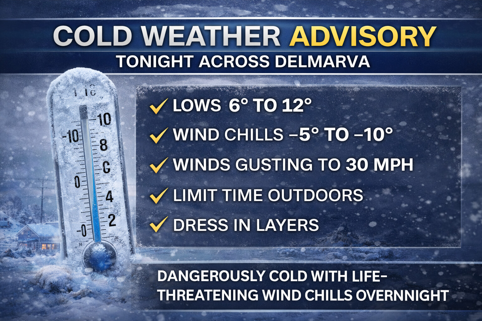
A Cold Weather Advisory is in effect tonight across the Delmarva Peninsula as a dangerous surge of arctic air settles into the region. Mostly clear skies combined with strong winds will allow temperatures to fall rapidly after sunset, creating life-threatening cold conditions overnight into early Saturday morning.
Overnight lows are expected to range between 6 and 12 degrees, but north winds of 10 to 20 mph with gusts up to 30 mph will dramatically increase the cold impact. As a result, wind chill values are expected to fall below zero across much of Delmarva, with several locations dropping into the -5 to -10 degree range by the pre-dawn hours.
The coldest wind chills are expected across interior sections of the peninsula, while coastal areas will still experience bitter conditions despite some marine influence. These wind chills can cause frostbite on exposed skin in as little as 30 minutes, especially with prolonged exposure.
Residents are urged to limit time outdoors, dress in multiple layers including hats and gloves, and ensure pets are brought indoors. Exposed pipes should be protected, and those relying on supplemental heating should use it safely. Power outages are not expected to be widespread, but strong gusts could lead to isolated issues.
Conditions will slowly improve after sunrise Saturday, though temperatures will remain well below normal, and cold weather precautions will remain necessary throughout the day.
Stay weather aware and prepared for hazardous cold conditions across the Delmarva region tonight.
A complex and potentially high-impact winter storm is expected to affect the Mid-Atlantic this weekend, bringing a combination of snow, sleet, and freezing rain from Saturday into Monday. While confidence is increasing that much of the region will be impacted, significant uncertainty remains regarding exact precipitation types and totals due to a difficult forecast setup involving strong warm air advection overriding very cold surface temperatures.
This setup raises the risk for not only accumulating snow, but also dangerous icing, particularly across parts of Maryland, Delaware, New Jersey, and the Delmarva Peninsula.
Snowfall Forecast Overview
The heaviest snowfall is expected across northern and western portions of the region, where colder air is more firmly established.
Across northern Maryland, including areas such as Frederick, Westminster, Bel Air, Baltimore, and Wilmington, snowfall totals of 8 to 12 inches are possible by the time the storm concludes.
Farther south and east, including Washington, Annapolis, Easton, Dover, and much of central Maryland and Delaware, snow totals are expected to range between 5 and 10 inches. Snowfall amounts begin to decrease closer to the coast as warmer air aloft works into the region.
Along the immediate coast and across portions of southern Delmarva, including Salisbury, Ocean City, and Pocomoke City, snowfall totals are forecast to range from 4 to 8 inches, with lower amounts of 3 to 6 inches possible for coastal Virginia locations such as Chincoteague, Exmore, and Cape Charles.
Significant Ice Threat Also Expected
In addition to snow, portions of the Mid-Atlantic face a serious icing risk due to periods of freezing rain and sleet.
Areas shaded in darker purple on the ice forecast indicate significant icing, where ice accretion of one quarter inch or greater is possible, along with 1 to 3 inches of sleet. This includes parts of central Maryland, the western shore of the Chesapeake Bay, and portions of interior Delaware.
Surrounding areas shown in lighter pink could still see impactful icing, with less than one quarter inch of ice accumulation and 1 to 2 inches of sleet possible. Even lighter ice amounts can cause hazardous travel, downed tree limbs, and isolated power outages.
Why This Forecast Is So Difficult
This storm is particularly challenging to forecast due to strong warm air advection aloft, which allows warmer air to surge over top of a shallow layer of arctic air locked in at the surface. This creates a narrow and highly sensitive transition zone between snow, sleet, and freezing rain.
Small changes in temperature, storm track, or precipitation intensity could lead to sharp gradients in impacts over short distances. As a result, precipitation types and totals may vary significantly from one location to another, even within the same county.
Travel and Infrastructure Impacts
The combination of heavy snow and ice could lead to dangerous travel conditions throughout the weekend. Roads may quickly become snow covered or ice glazed, especially during periods of freezing rain. Ice accumulation also increases the risk of downed trees and power lines, which could result in scattered power outages.
Residents should be prepared for rapidly changing conditions and possible travel disruptions.
How to Prepare
Residents across the Mid-Atlantic are urged to take preparation steps now, ahead of the storm:
Avoid unnecessary travel during the height of the storm.
Keep an emergency kit ready with flashlights, batteries, food, water, and medications.
Charge electronic devices ahead of time in case of power outages.
Check on elderly neighbors and those with limited mobility.
If you must travel, keep a winter survival kit in your vehicle including blankets, food, and a fully charged phone.
Monitor the latest forecasts and updates, as adjustments to snow and ice totals are likely.
Bottom Line
This weekend’s winter storm has the potential to bring heavy snow, significant icing, and hazardous travel conditions across much of the Mid-Atlantic. While confidence is high that the region will be impacted, the exact nature of those impacts remains uncertain due to the complex interaction between warm air aloft and very cold surface temperatures.
Residents are encouraged to stay weather aware and prepared as the forecast continues to evolve over the coming days.
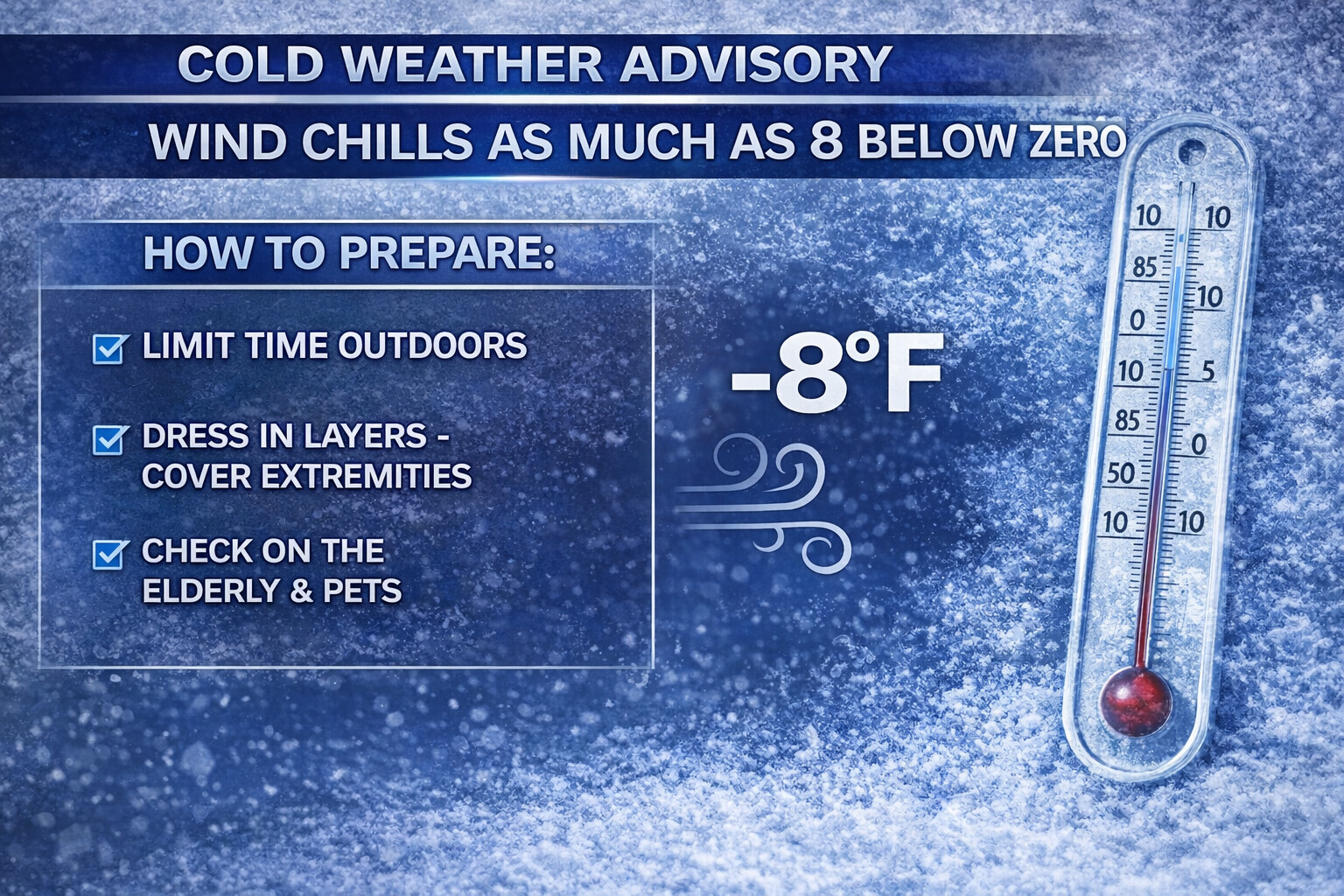
…COLD WEATHER ADVISORY IN EFFECT FROM MIDNIGHT FRIDAY NIGHT TO 10 AM EST SATURDAY…
* WHAT…Very cold wind chills as low as 8 below expected.
* WHERE…Portions of central, northern, and southern Delaware, northeast Maryland, central, northern, and southern New Jersey, and southeast Pennsylvania.
* WHEN…From midnight Friday Night to 10 AM EST Saturday.
* IMPACTS…The cold wind chills as low as 8 below zero could result in hypothermia if precautions are not taken. Frostbite and hypothermia will occur if unprotected skin is exposed to these temperatures. Wind chill values can lead to hypothermia with prolonged exposure.
PRECAUTIONARY/PREPAREDNESS ACTIONS…
Use caution while traveling outside. Wear appropriate clothing, a hat, and gloves.
A significant winter storm is expected to impact the Mid-Atlantic this weekend, beginning late Saturday and continuing through Monday. The storm is forecast to bring a wide range of winter weather impacts across the region, including heavy snowfall, mixed precipitation, and areas of freezing rain, particularly across Delmarva and southern portions of Maryland and New Jersey.
Snowfall Outlook
The heaviest snowfall is expected across northern and western portions of the region. Much of northern Maryland, including areas such as Frederick, Westminster, Baltimore, Bel Air, and Gaithersburg, along with northern Delaware and southern New Jersey, could see widespread snowfall totals of 12 to 18 inches. Wilmington, Vineland, and surrounding communities also fall within this higher-impact zone.
Snow totals decrease moving south and east toward the Chesapeake Bay and coastal plain. Central Maryland locations such as Annapolis and Chestertown are forecast to receive 8 to 14 inches of snow. Areas farther south, including Easton, Cambridge, La Plata, and Lexington Park, are currently forecast to receive 6 to 12 inches.
Across southern Delmarva and the lower Eastern Shore, snowfall amounts are expected to be lower due to warmer air and a greater risk of mixing. Salisbury is forecast to receive 5 to 10 inches, while Ocean City, Pocomoke City, Chincoteague, Exmore, and Cape Charles are expected to see between 3 and 6 inches of snow.
Ice and Mixed Precipitation Concerns
In addition to snowfall, icing is a major concern for parts of the region. A corridor of significant icing is possible across southern and central Delmarva, including areas such as Georgetown, Salisbury, Ocean City, Pocomoke City, Chincoteague, and Cape Charles. These areas could experience up to a quarter inch of freezing rain, along with the potential for sleet accumulations exceeding one half inch. This could lead to hazardous travel conditions and the potential for power outages.
Farther north, including parts of northern Maryland, northern Delaware, and southern New Jersey, lighter icing is possible. These areas may see up to a tenth of an inch of freezing rain, along with periods of sleet, mainly during transitions between snow and rain.
Impacts and Timing
Travel conditions are expected to deteriorate rapidly late Saturday night as precipitation overspreads the region. The most significant impacts are likely to occur Sunday into early Monday, when snowfall rates may become heavy at times and icing issues increase across southern areas. The combination of heavy snow, ice accumulation, and gusty winds could lead to dangerous road conditions and scattered power outages.
Weather First will continue to monitor this evolving storm closely. While confidence is increasing in a high-impact winter weather event, exact snow and ice totals may still shift depending on the storm track and temperature profile.
Residents are urged to prepare now, review travel plans, and stay tuned for forecast updates as the weekend approaches.
A dangerous surge of Arctic air is expected to spread across the Mid-Atlantic region late this week and persist into early February, bringing some of the coldest conditions of the winter season so far. Forecast confidence continues to increase that this will be a prolonged and impactful cold stretch rather than a brief cold snap.
An Arctic front is forecast to move through the region this weekend, allowing frigid air to pour southward into Maryland, Delaware, Virginia, and surrounding areas. Temperatures are expected to fall sharply behind the front, with daytime highs struggling well below normal and overnight lows dropping into the teens and single digits in many locations. Some inland and higher elevation areas may fall even colder.
Strong winds accompanying the Arctic air will significantly worsen conditions by driving wind chills into dangerous territory. Wind chill values are expected to drop below zero at times across parts of the Mid-Atlantic, especially overnight and during the early morning hours. These conditions can lead to frostbite on exposed skin in a short amount of time and increase the risk of hypothermia for anyone spending extended periods outdoors.
The cold is expected to linger well beyond the weekend. Forecast trends indicate much below normal temperatures continuing through the end of January and into early February, with a heightened risk of hazardous cold conditions returning in waves. This suggests limited opportunities for meaningful warmups during this period.
The prolonged nature of the cold raises concerns for frozen pipes, increased energy demand, and stress on infrastructure. Any power outages that occur during this time could quickly become dangerous due to the sustained cold. Pets, livestock, and outdoor plumbing will need protection as temperatures remain well below seasonal averages.
Residents across the Mid-Atlantic should prepare now for an extended stretch of winter cold. Cold weather safety precautions are strongly encouraged, including limiting time outdoors, dressing in layers, protecting exposed skin, and ensuring adequate heating is available.
Additional updates will be provided as the timing and severity of the cold become more refined.
Dover authorities have arrested a school bus driver after surveillance video captured him engaging in sexual activity with a woman on his bus while parked in a residential area.
Alvin Rohm, 62, of Dover, faces charges of patronizing a prostitute within 1,000 feet of a school, residence, church or other place, as well as lewdness, according to Dover Police.
The investigation began when a local school district employee was examining bus video footage as part of an unrelated matter on January 6th, 2026. During that review, the employee discovered recordings that showed Rohm collecting a woman near the intersection of Governors Avenue and Loockerman Street before driving to Jerusalem Way.
According to Lt. Mark Hoffman, Dover Police Public Information Officer, the video evidence showed Rohm participating in sexual acts with the woman and exchanging money for those services while the bus was parked on Jerusalem Way.
Police clarify that Rohm was not directly employed by the school district but rather worked for a private company that provides transportation services under contract.
School officials immediately turned over the video evidence to Dover Police, who launched their own investigation into the matter.
Authorities took Rohm into custody on January 12th without any complications. He was subsequently released on his own recognizance bond pending further court proceedings.
The case highlights the importance of surveillance systems on school buses and the ongoing oversight of contracted transportation services in the Dover area.
Confidence continues to grow that a significant winter storm will impact much of the Mid Atlantic, including the Delmarva Peninsula, beginning Saturday night and potentially lasting into Monday. While there is still uncertainty regarding the exact track and where the heaviest snowfall sets up, the overall signal for a high impact event continues to strengthen.
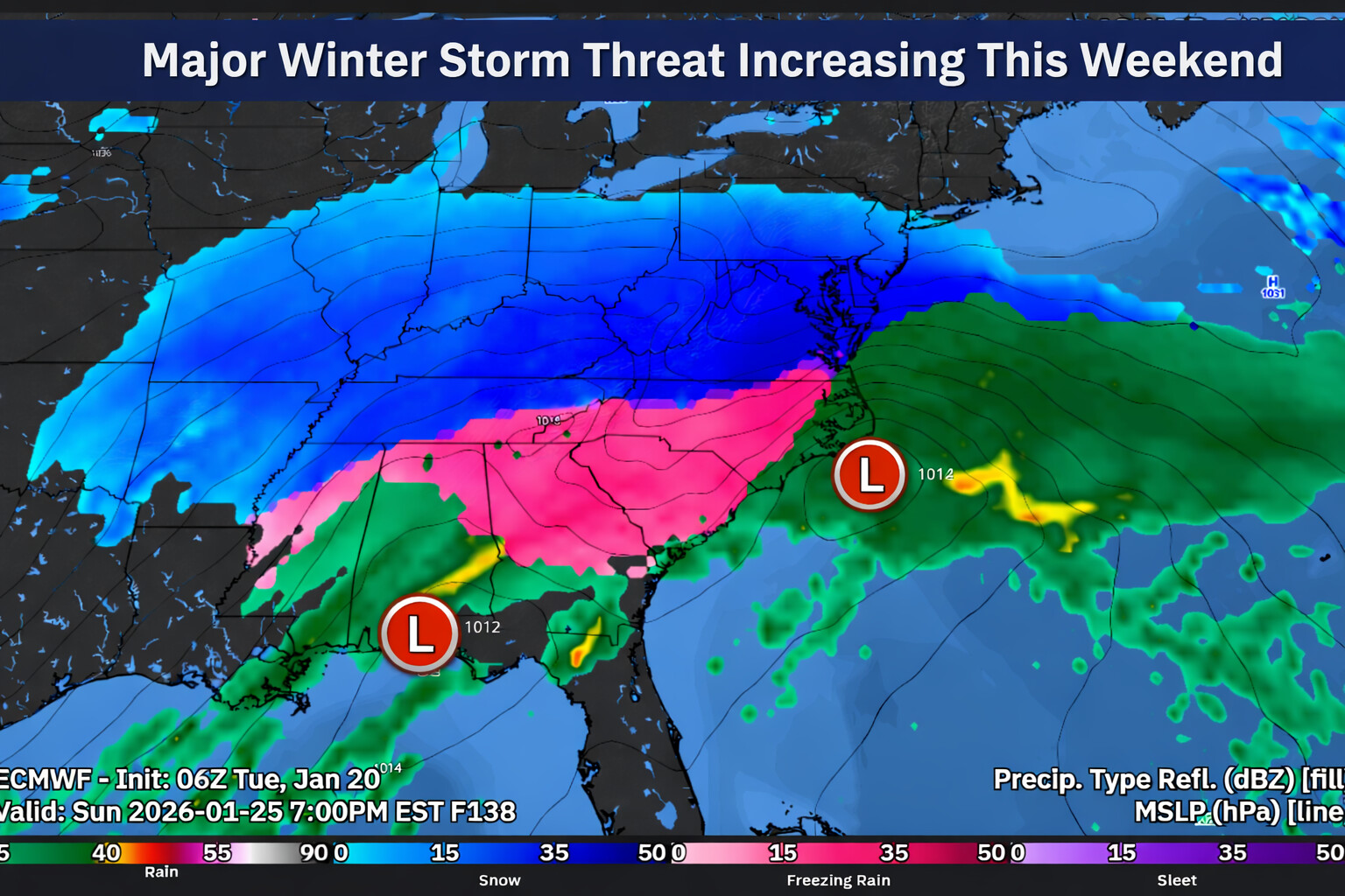
A developing area of low pressure is expected to organize near the Texas Gulf Coast on Saturday. This system will be fueled by several pieces of upper level energy diving south into the base of a persistent long wave trough dominating much of the continental United States. As these upper level disturbances interact and begin to phase Saturday night into Sunday, surface low pressure is expected to deepen while tracking east through the southeastern states and then turning north and east toward the Virginia coastline by late Sunday.
Forecast guidance has continued to trend northward with the track of the low, largely due to improved phasing of the upper level energy. While this trend increases confidence that the storm will affect the region, it also introduces uncertainty regarding snowfall totals and precipitation type, particularly for southern and coastal locations.
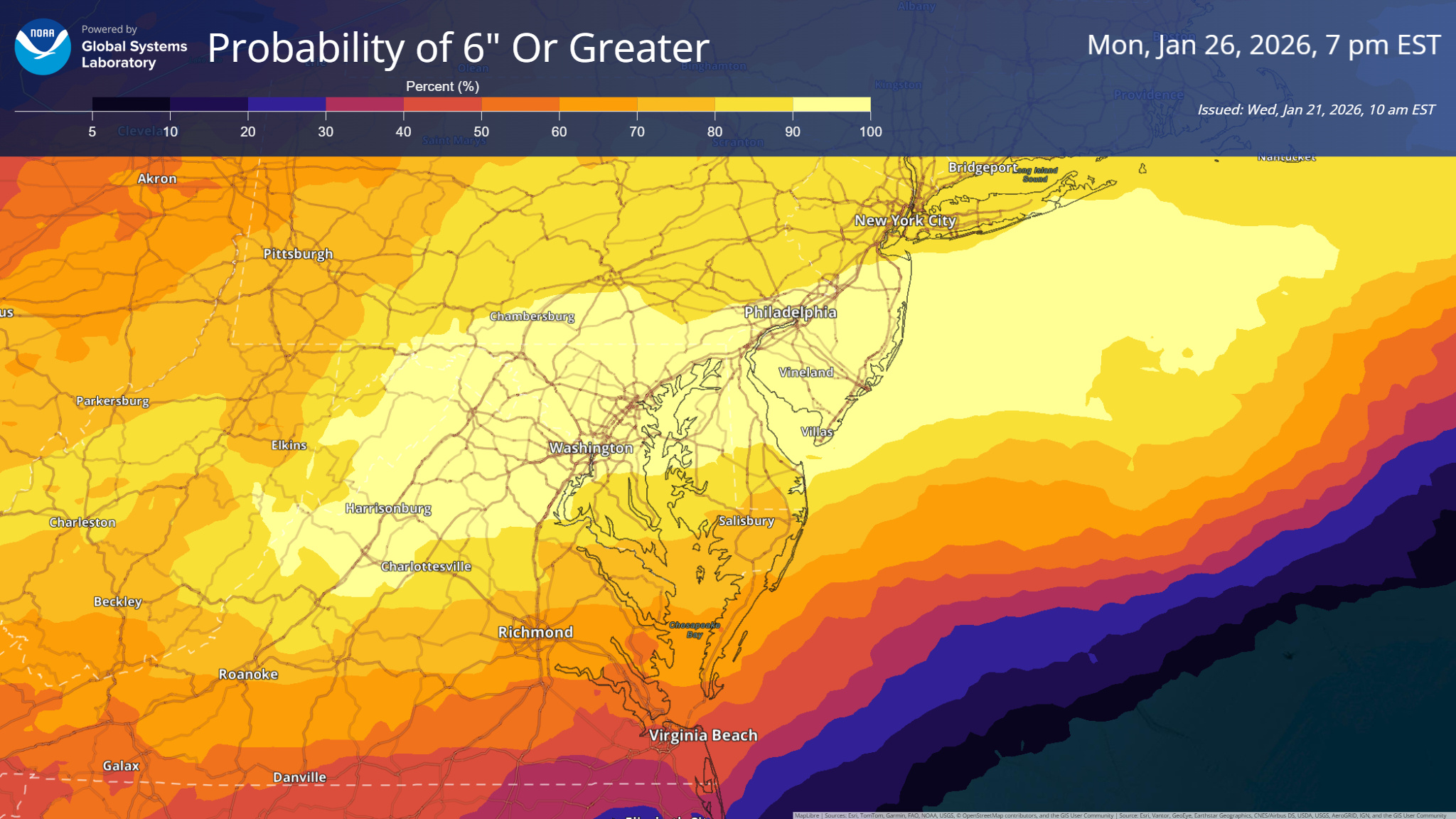
At this time, confidence is high that much of the region will see moderate to heavy snowfall. Probabilities for six inches or more of snow have increased significantly, ranging from around 60 percent in the southern Poconos to as high as 80 to 90 percent near and south of the I 95 urban corridor. Many areas also have the potential to receive over one inch of liquid equivalent precipitation, which supports the potential for impactful snow totals.
Snow is expected to break out across the region late Saturday night into Sunday morning. Temperatures will be cold enough at the onset for all snow, with overnight lows dropping into the single digits across northern areas and into the teens to near 20 degrees across Delmarva. These cold temperatures should initially support efficient snow accumulation.
Snow is likely to continue through the day Sunday and may fall heavy at times, especially as northeast winds increase, particularly along the coast. Late Sunday into Sunday night, there is the potential for some mixing across southern portions of the region, including Delmarva and parts of southern New Jersey, and possibly as far north as the Philadelphia area if the low tracks close enough to the coast. Given the strength of the arctic high pressure to the north and the entrenched cold air mass, plain rain appears less likely. Any mixing would more likely involve sleet or freezing rain rather than a full changeover to rain.
If mixing does occur, a return to all snow is expected later Sunday night into early Monday as colder air reasserts itself and the system begins to pull away. Precipitation should gradually taper off across the region during the day Monday.
While confidence has increased that this will be a significant winter storm, uncertainty remains regarding where the heaviest snowfall ultimately falls. Just 24 hours ago, the primary concern was whether the storm would pass far enough south to largely miss the area. Now, the focus has shifted to whether the track becomes far enough north to introduce mixing for southern and coastal locations.
As is often the case with large winter storms, the corridor of heaviest snowfall is typically narrow, sometimes only 100 miles wide. Areas southeast of this axis may experience more mixing or lower snow totals, while areas northwest may see lighter precipitation. Because of this, it will likely take another one to two forecast cycles to better resolve where any potential blockbuster snowfall sets up within the region.
Residents across Delmarva and the surrounding Mid Atlantic should closely monitor forecast updates over the coming days, as even small shifts in the storm track could have a significant impact on snowfall totals and overall impacts.
Forecast confidence is increasing that a potentially impactful winter storm could affect the Delmarva region late Saturday through Sunday, though important details regarding track and snowfall amounts remain uncertain at this time.
Weather patterns aloft are becoming increasingly active as we head toward the weekend, with interactions expected between northern and southern jet stream systems. The energy driving this setup is currently located over the Arctic and the Pacific Ocean, meaning it will take several more days for forecasts to fully resolve how this system evolves. Even so, most forecast guidance now consistently shows an area of low pressure developing near Texas on Friday before moving east along the Gulf Coast into Saturday.
As the system approaches the East Coast, guidance generally favors the low tracking northeast toward the North Carolina coast before moving offshore late Sunday into early Monday. This type of track would place Delmarva on the colder, northern side of the storm, increasing the potential for winter weather impacts across the region. A key question remains how close the storm tracks to the coastline, as even small shifts could have a major influence on snowfall totals.
A strong arctic high pressure system will be positioned to the north, supplying cold air into the Mid Atlantic. Earlier forecast guidance suggested this high might suppress the storm farther south, limiting impacts locally. However, trends over the past 12 to 24 hours show the storm track edging farther north, increasing the likelihood that precipitation spreads into Delmarva.
Snow probabilities have responded accordingly. Current guidance now indicates a 75 to 95 percent chance of at least 2 inches of snow and a 70 to 85 percent chance of 6 inches or more for areas along and south of the Interstate 95 corridor, with probabilities decreasing farther north.
Even more impressive with NBM blends of >12 inches of snow are between 50-60% as of this morning. These numbers are notably higher than those from previous forecast cycles and point toward a growing signal for a meaningful winter weather event.
If this storm materializes, snowfall could begin late Saturday and continue through Sunday, with the potential for lingering impacts into Monday depending on how quickly the system moves away. While confidence in exact snowfall totals remains low, the overall signal for a winter storm affecting at least part of Delmarva is stronger than typically seen at this lead time.
It is important to note that East Coast winter storms often produce narrow bands of heavy snow, sometimes only 50 to 100 miles wide. With the storm’s key ingredients still thousands of miles away, it is far too early to determine which specific locations will see the highest accumulations. Residents across Delmarva should continue to monitor forecast updates closely over the coming days as details become clearer.
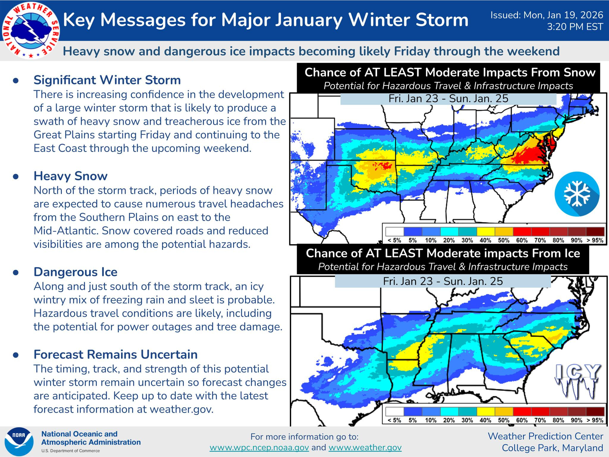
Confidence continues to increase in the development of a significant winter storm that is expected to impact a large portion of the central and eastern United States beginning Friday and continuing through the weekend. This system has the potential to produce a wide swath of heavy snow and dangerous ice, leading to hazardous travel and possible infrastructure impacts.
Current forecast trends indicate this storm will track from the Great Plains toward the East Coast, strengthening as it moves east. Areas north of the storm track are expected to see periods of heavy snow, while locations along and just south of the track face a heightened risk for freezing rain and sleet.
Heavy snow is likely across portions of the central Plains, Ohio Valley, and into parts of the Mid-Atlantic and Northeast. Snowfall rates could become intense at times, resulting in rapidly deteriorating road conditions, reduced visibility, and significant travel disruptions. Snow-covered roads and difficult driving conditions are expected where the heaviest bands develop.
South of the snow zone, dangerous ice accumulation is becoming increasingly likely. A wintry mix of freezing rain and sleet may create treacherous conditions, especially on untreated surfaces. Ice accretion raises concerns for downed trees and power outages, particularly in areas that experience prolonged freezing rain.
There is a growing signal for at least moderate winter storm impacts from Friday through Sunday. These impacts include hazardous travel, disruptions to daily routines, and possible damage to infrastructure. The combination of snow, ice, and cold temperatures could make conditions especially dangerous during peak travel periods.
While confidence in a high-impact winter storm is increasing, some uncertainty remains regarding the exact track and timing. Small shifts in the storm’s path could significantly change where the heaviest snow and ice set up. Forecast details will continue to be refined as the system approaches.
Residents across the affected regions should begin preparing now for potentially dangerous winter weather conditions this weekend. Additional updates will be issued as confidence continues to improve and impacts become clearer.
This is the largest solar radiation storm in over 20 years. The last time S4 levels were observed was in October, 2003
Space weather officials confirm the Earth is now experiencing an S4 (Severe) solar radiation storm, a significant escalation in space weather conditions triggered by a powerful X2-class solar flare that erupted from the Sun roughly 48 hours ago. The delayed arrival of high-energy solar particles is consistent with this type of event and marks a period of increased risk for aviation, satellite operations, and space-based technology.
According to the NOAA Space Weather Prediction Center, S4 radiation storms are among the strongest levels on the solar radiation scale and occur when energetic protons accelerated by a solar flare and associated shock wave reach Earth.
What Is an S4 Solar Radiation Storm?
Solar radiation storms are classified from S1 (Minor) to S5 (Extreme) and are driven by high-energy particles, primarily protons, traveling outward from the Sun at near-relativistic speeds. An S4 storm indicates severe radiation levels in near-Earth space, capable of producing real-world impacts beyond just auroras.
While geomagnetic storms mainly affect Earth’s magnetic field, radiation storms directly impact satellites, aircraft at high altitudes, and astronauts.
Hazards and Potential Impacts
During an S4 radiation storm, several hazards become more likely:
Aviation Impacts
Flights on polar and high-latitude routes may be forced to reroute to lower latitudes
High-frequency (HF) radio communication used by transpolar flights can become unreliable or unavailable
Increased radiation exposure for flight crews and passengers on long-haul polar flights
Satellite and Space Systems
Elevated radiation levels can cause single-event upsets, memory errors, or temporary malfunctions in satellites
Increased drag and sensor noise may degrade satellite performance
Some spacecraft operators may place satellites into protective safe modes
Astronaut Safety
Astronauts aboard the International Space Station may take protective measures, including moving to more shielded areas
Spacewalks are typically postponed during severe radiation events
Radio and Navigation Disruptions
HF radio blackouts are possible, especially over polar regions
GPS accuracy may be reduced due to increased ionospheric disturbance
What This Means for the Public
For most people on the ground, direct impacts remain limited, and radiation levels at Earth’s surface remain safe. However, this storm underscores the heightened level of solar activity currently underway and why space weather is closely monitored.
Looking Ahead
Radiation storms can persist for several days, depending on how long elevated particle flux continues. Additional flares from the same active solar region could prolong impacts or intensify conditions further.
Forecasters continue to monitor solar activity closely, as strong radiation storms often occur alongside or shortly before geomagnetic storm conditions, which could increase the chance for auroras at lower latitudes in the coming days.
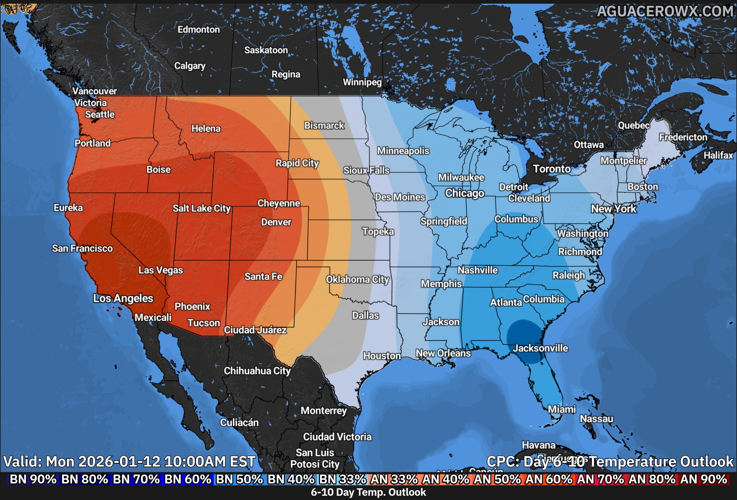
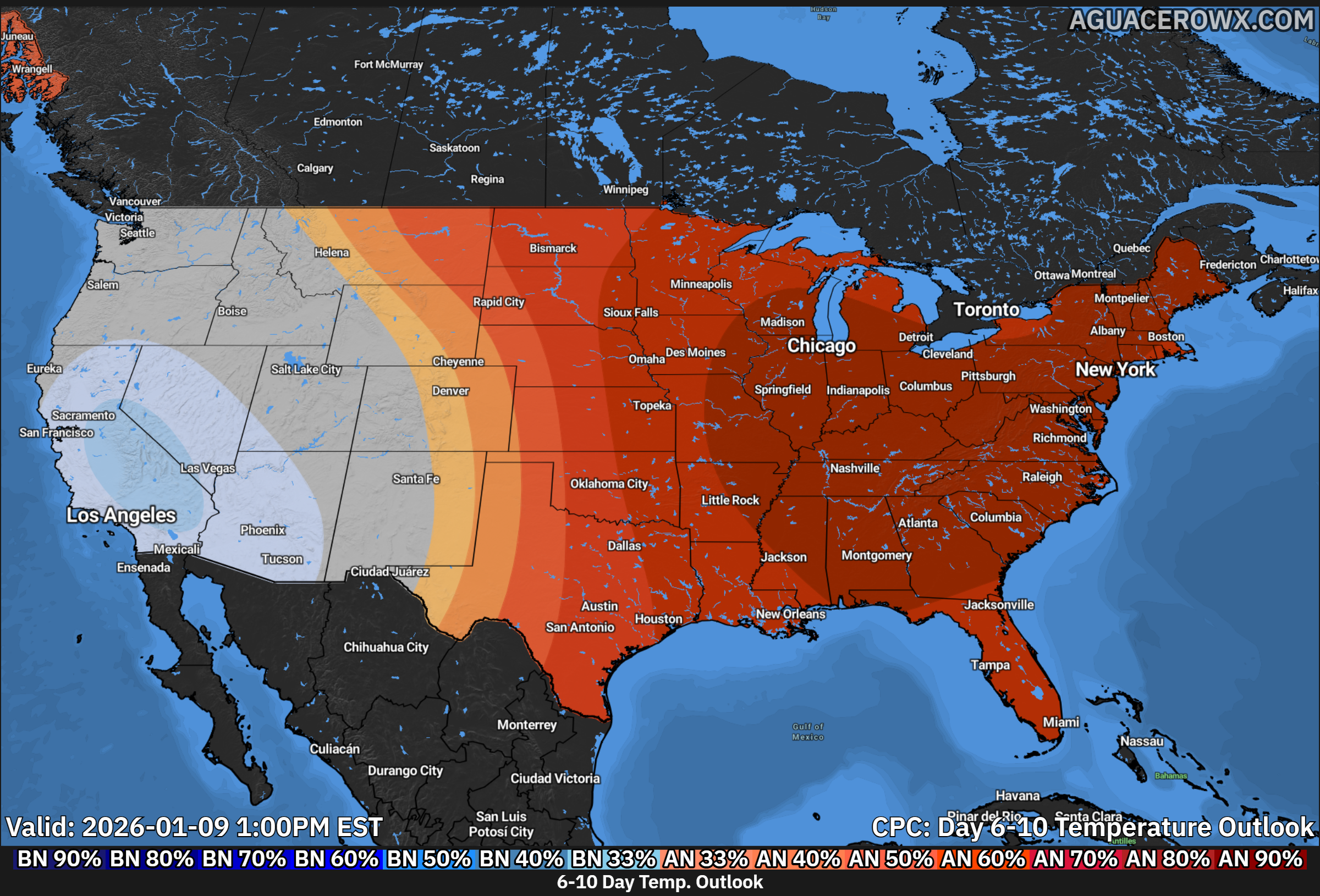
A prolonged stretch of colder than normal temperatures is becoming increasingly likely across much of the eastern United States as we move deeper into late January. The latest temperature outlooks from the Climate Prediction Center show a strong and persistent signal for below average temperatures developing during both the 6–10 day and 8–14 day forecast periods.
The 6–10 day outlook highlights a broad area of colder than normal conditions expanding from the Midwest into the Ohio Valley, Mid-Atlantic, and Northeast. The highest confidence for below normal temperatures is centered over the Great Lakes and interior Northeast, where probabilities strongly favor temperatures well below seasonal averages. This colder air mass is expected to gradually spread eastward and southward as the pattern evolves.
By the 8–14 day timeframe, the cold signal strengthens and becomes more entrenched across the eastern half of the country. Much of the Mid-Atlantic, Southeast, and Northeast show a high likelihood of sustained below normal temperatures, indicating that this will not be a brief cold snap. Instead, forecast guidance suggests repeated intrusions of Arctic air reinforcing the cold pattern well into early February.
Meteorologically, this setup is driven by a strong ridge of high pressure over the western United States and a deep trough anchored across the eastern U.S. This configuration allows cold air from Canada to repeatedly spill southward, keeping temperatures suppressed for an extended period. While the western U.S. remains warmer than average under the ridge, the eastern states remain locked in a colder regime.
For residents across the Mid-Atlantic and Northeast, this pattern could bring multiple days of daytime highs running well below normal, along with colder overnight lows. The persistence of the cold also raises the potential for increased energy demand, frozen pipes, and heightened vulnerability for those without adequate heating. Any storm systems that develop during this period would also need to be closely monitored, as the presence of cold air could support winter weather threats.
Forecast confidence is increasing that this cold stretch will be one of the more significant and long-lasting cold periods of the season for the eastern United States. Residents are encouraged to prepare for prolonged winter conditions and stay updated as forecasts are refined in the coming days.
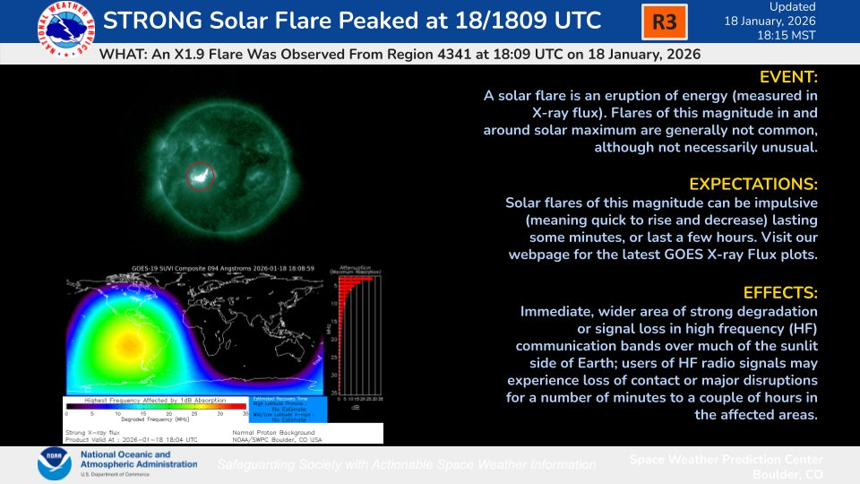
A strong solar flare, classified as an X1.9 event, erupted from the Sun on January 18, 2026, peaking around 18:09 UTC, according to the NOAA Space Weather Prediction Center. This flare originated from Active Region 3431, a magnetically complex sunspot group currently facing Earth.
Space weather forecasters are tracking a G4 (Severe) geomagnetic storm affecting Earth’s magnetic environment tonight, raising the possibility of rare auroral displays visible across mid-Atlantic skies, including the Delmarva region.
What Is a G4 Magnetic Storm?
A geomagnetic storm occurs when charged particles from the Sun, often launched by a solar flare or coronal mass ejection (CME), slam into Earth’s magnetosphere and disturb its magnetic field. The intensity of these storms is measured on the NOAA Space Weather Scale from G1 (minor) to G5 (extreme). A G4 storm represents severe levels of geomagnetic activity, indicating strong magnetic fluctuations and a heightened potential for vivid auroras at unusually low latitudes.
During a G4 event:
Particles from the Sun funnel into the upper atmosphere near the poles and excite atoms like oxygen and nitrogen, creating luminous curtains of light known as the aurora borealis.
The auroral zone expands, sometimes far south of its normal range, allowing observers in mid-latitude regions (including the Mid-Atlantic) to see lights typically confined to far northern skies.
Geomagnetic storms at this level can also affect radio communications, GPS accuracy, and in rare cases electric power systems, though modern grids are usually resilient.
Aurora Potential Tonight for Delmarva
Forecasters monitoring the aurora forecast models say the current geomagnetic activity could push the auroral oval southward toward the mid-Atlantic. Under G4 conditions, auroras have in the past been reported as far south as the southeastern United States, with some displays reaching states like Florida and Alabama during strong storms.
For observers in Delaware and the broader Delmarva region, this means:
Timing: The best chances for sightings are typically after local sunset through the late evening and into the early morning hours. Auroras are most visible when the sky is fully dark.
Colors & Forms: If visible, the lights may appear as greenish glows or shimmering curtains, occasionally with hints of red or pink at the edges, depending on atmospheric conditions and storm strength.
Visibility Factors: Clear skies and low light pollution will improve viewing prospects. Urban lighting and cloud cover can wash out faint auroral activity.
This level of geomagnetic storming is rare for mid-latitude regions like the Mid-Atlantic, and any display would be an unusual and noteworthy event for skywatchers in the area.
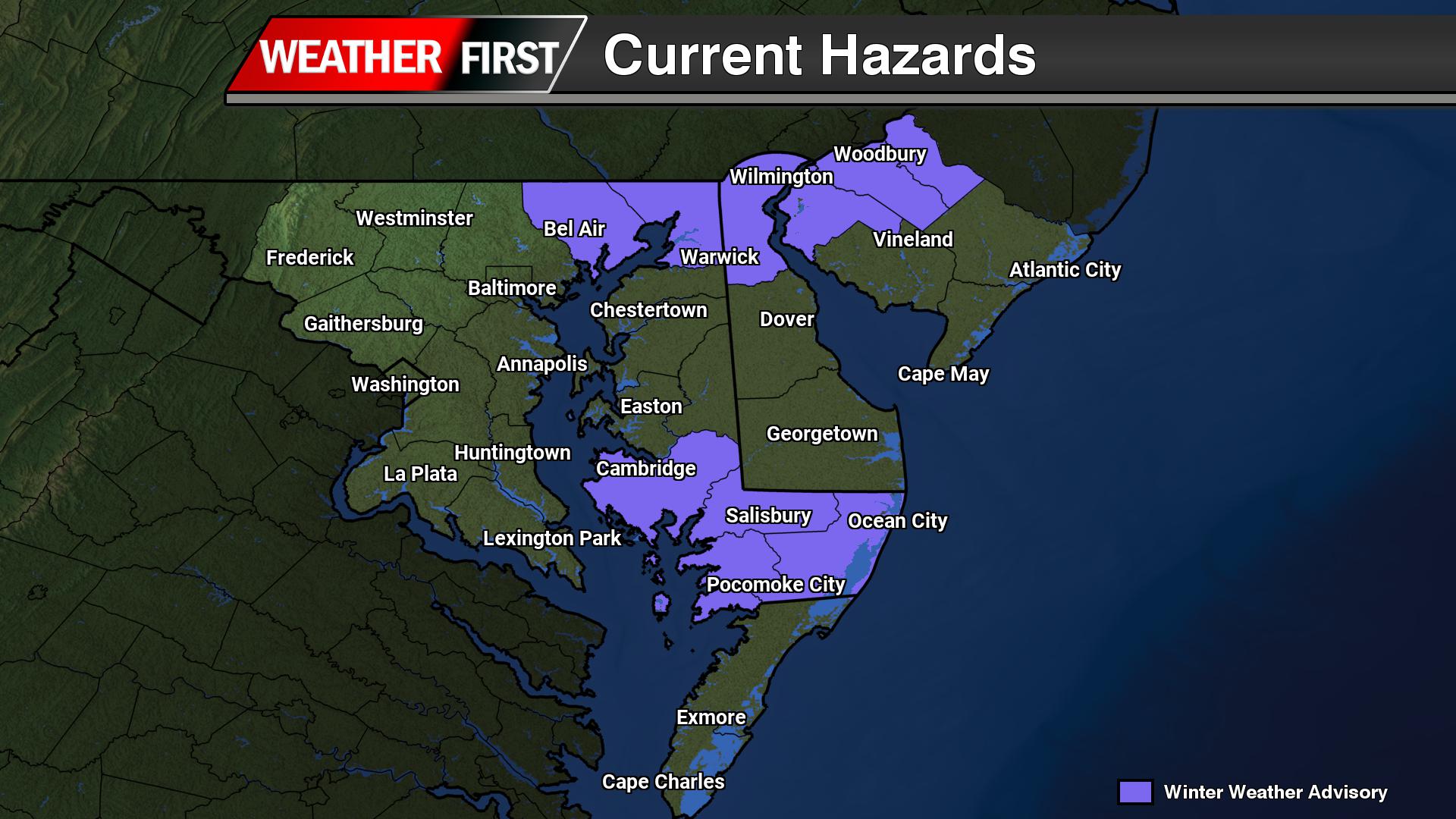
...WINTER WEATHER ADVISORY IN EFFECT FROM 10 AM TO 10 PM EST
SUNDAY...

* WHAT...Wet snow expected. Total snow accumulations up to two
  inches.

* WHERE...Dorchester, Inland Worcester, the Maryland Beaches,
  Somerset, and Wicomico Counties.

* WHEN...From 10 AM to 10 PM EST Sunday.

* IMPACTS...Plan on slippery road conditions.

* ADDITIONAL DETAILS...The advisory may need to be expanded
  southward with future updates if the snow forecast continues to
  trend upward.

PRECAUTIONARY/PREPAREDNESS ACTIONS...

Slow down and use caution while traveling. Call 511 for road
information.
A prolonged stretch of below normal temperatures is expected to grip the Delmarva region beginning Sunday and lasting through the middle of next week, with the most dangerous cold arriving Monday night into Tuesday.
A deep upper level trough will settle over the eastern United States, allowing an arctic air mass to surge southward into the Mid Atlantic. At the surface, strong high pressure will dominate the region, keeping conditions dry but doing little to prevent temperatures from falling sharply.
Cold air will steadily build into the region starting Sunday, with daytime temperatures remaining well below average through at least Wednesday. The core of the arctic air mass is expected to be centered over Delmarva Monday night through Tuesday night, when the cold will be at its most intense.
During this time, overnight wind chill values are expected to fall into the single digits and potentially below zero, especially during the overnight and early morning hours. Current indications suggest Monday night will be the coldest period, with slightly less extreme conditions expected Tuesday night.
Daytime temperatures on Tuesday are also trending colder, with highs forecast to struggle into the upper teens to low 20s across much of Delmarva. These values are well below normal for mid January and could pose risks to anyone spending extended time outdoors.
Given the severity of the cold, cold weather advisories or warnings may be issued for one or both nights. Residents are encouraged to prepare now by limiting outdoor exposure, protecting pets, and ensuring vulnerable pipes and plumbing are properly insulated.
Temperatures are expected to gradually moderate later in the week as the upper level trough begins to lift, allowing readings to trend closer to seasonal averages by Thursday.
A developing storm system will bring a period of light snow early Saturday morning before transitioning to rain for many locations as the day goes on. The highest chances for accumulating snow will be found near and northwest of the Interstate 95 corridor, with the greatest totals expected farther north.
An upper level trough will be positioned over the eastern United States this weekend, allowing several smaller disturbances to move through the region. The first of these systems is expected to arrive during the pre dawn hours on Saturday. As it moves in, increasing lift in the atmosphere and a gradual influx of milder air aloft will help precipitation develop.
Forecast guidance now suggests the system will be slightly more organized than previously expected. As a result, rainfall totals have increased modestly. Areas near and northwest of I 95 are expected to receive between one tenth and two tenths of an inch of liquid precipitation through Saturday, while locations southeast of I 95 are likely to remain under one tenth of an inch.
Precipitation is expected to begin mainly as snow early Saturday before gradually changing to rain from southeast to northwest. Little to no snow accumulation is expected southeast of the I 95 corridor before the transition occurs. Near and just northwest of I 95, snowfall amounts should range from a light dusting up to one inch.
Farther north, including the Lehigh Valley, northwest New Jersey, and the southern Poconos, colder air will allow snow to persist longer. In these areas, snowfall totals are now forecast to reach one to two inches, with up to three inches possible at higher elevations in the southern Poconos where rain mixing may be limited.
Watching a Coastal System for Sunday
Attention then turns to a separate storm system expected to develop offshore late in the weekend. This coastal low is forecast to form near the Outer Banks and track northeastward on Sunday. At this time, the overall threat for a significant snowfall remains low.
Most forecast models continue to favor a track well offshore, which would limit impacts across the region. Under the current forecast, light snow is possible along the coast and areas south and east of I 95 on Sunday, while locations farther inland may see little or no accumulation.
There is still some uncertainty, as a small number of ensemble models suggest a closer track could occur. However, confidence in that scenario remains low. Probabilities for advisory level snowfall remain modest, generally around 20 to 25 percent at the immediate coast, decreasing farther inland.
Current snowfall forecasts call for around one half inch to one and a half inches along the coast and southern Delaware, with a coating to one inch possible up to the I 95 corridor. North and west of I 95, only a few flurries or trace amounts are expected.
Any precipitation associated with this system is expected to taper off Sunday night as the storm pulls farther offshore.
The Mid-Atlantic region continues to grapple with expanding dry conditions this winter, with drought intensifying across much of the area, according to the latest update from the United States Drought Monitor.
The U.S. Drought Monitor map released this week shows that moderate to severe drought conditions have grown across key parts of the Mid-Atlantic, including central Maryland and large portions of central Virginia. While some northern areas of Pennsylvania experienced wetter conditions, southern and eastern portions of the region have remained dry, allowing drought to deepen.
Abnormally dry conditions now extend through wide swaths of the Mid-Atlantic. The Monitor categorizes drought severity on a scale from D0 (abnormally dry) to D4 (exceptional drought), and recent assessments show that drought categories have climbed across the region as a result of ongoing precipitation deficits and above-normal temperatures.
Officials say the dry pattern is tied largely to below-average rainfall and snowfall over recent months. Water resources, including streamflow and groundwater levels, have been slow to recover, particularly in areas that saw little relief from fall and early winter precipitation. Some parts of the region have already enacted water restrictions for residents and agriculture due to low reservoir and river levels.
Forecasters with NOAA’s Climate Prediction Center warn that drought persistence is likely through the late winter and early spring, as the outlook shows no strong signal for widespread heavy precipitation in the Mid-Atlantic. Climatologists note that any recovery will be gradual, and areas with long-term moisture deficits may continue to see dry conditions linger well into the spring months.
The drought’s effects are being felt across industries and ecosystems. Farmers report increasingly dry fields that have challenged winter cover crops and pasture lands. Municipal water managers are monitoring reservoir levels and preparing for the possibility of expanded water use restrictions as the season progresses. Ecologists also warn that prolonged dry conditions could strain forests, wetlands, and aquatic habitats already stressed by low streamflows.
Residents across the Delmarva region will want to stay weather aware this weekend as multiple rounds of precipitation are possible, including the potential for snow. Forecast confidence remains moderate to low, but the overall pattern supports unsettled conditions from Saturday through Sunday night.
A broad area of low pressure aloft, known as a longwave trough, will settle over the eastern United States this weekend. Several smaller disturbances moving through this pattern will help generate periods of precipitation, beginning early Saturday and possibly continuing into Sunday night.
The first system is expected to move through Saturday morning and appears to be relatively weak. Precipitation may begin near or shortly after daybreak, when temperatures are at their coldest. Some locations could see a brief mix or light snow at the onset, especially inland areas, before temperatures rise through the morning. As daytime heating and weak warm air move in, most of Delmarva should transition to light rain. Any snow accumulation during this first round is expected to be minimal, with little more than a trace for most areas. Overall precipitation amounts should remain under a tenth of an inch.
Attention then turns to a second system that could develop offshore late Sunday into Sunday night. This system carries more uncertainty and higher potential impacts, depending largely on how close the surface low tracks to the coast. Recent forecast guidance has shown a slight shift toward a closer approach, which has increased the chance for precipitation across the region, especially near coastal areas.
With a cold front moving through Saturday night, colder air will be in place on Sunday. If the offshore low tracks close enough, much of the precipitation could fall as snow, particularly during the latter half of Sunday and into Sunday night. At this time, the probability of seeing measurable snow across coastal Delmarva is around 35 to 50 percent (of greater than 1″), with lower chances farther inland. The likelihood of higher snowfall amounts remains low, but it cannot be ruled out if the storm trends closer to the coast.
While confidence has increased slightly compared to earlier forecasts, there is still considerable uncertainty regarding the exact track and strength of this system. Residents across Delmarva should continue to monitor the forecast through the weekend, as small changes in storm position could significantly impact precipitation type and amounts.
More updates will be provided as forecast confidence improves.
WILMINGTON, Del. – Authorities in New Castle County are actively searching for a Maryland man accused of running home improvement scams targeting local residents.
Police have issued a warrant for 58-year-old Richard Kirchner, who lives in Elkton, Maryland. Kirchner faces charges related to several alleged fraudulent home improvement schemes.
The investigation began on January 14, 2026, when law enforcement officers were called to several homes along South Tupelo Turn in Wilmington’s Pepper Ridge Townhouse development.
According to the New Castle County Division of Police, their investigation revealed that Kirchner was connected to multiple fraudulent home improvement operations targeting residents in the area.
Anyone with information about Kirchner’s whereabouts is encouraged to contact the New Castle County Police immediately.
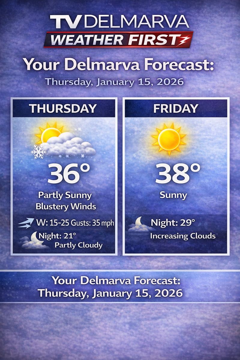
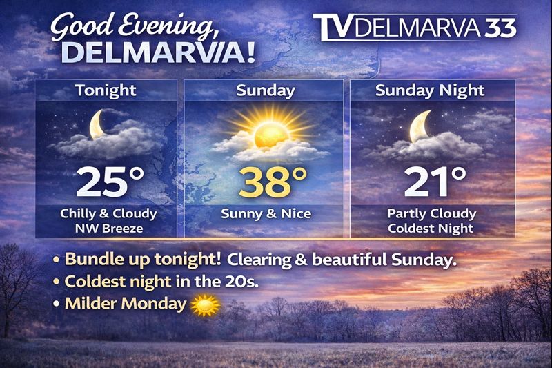
Good morning, Delmarva! We’re starting Thursday with a few lingering snow flurries through 7am, but don’t worry – any accumulation will be minimal. Once that clears out, we’re looking at a much brighter day with mostly sunny skies and a high of 36 degrees. Now, bundle up if you’re heading out today! We’ve got some gusty west winds at 15 to 20 mph, with gusts potentially reaching 35 mph. That’ll make it feel quite a bit chillier than our actual temperature, so grab that winter coat and maybe secure any loose outdoor items. Tonight turns partly cloudy and quite cold, with lows dropping to a brisk 21 degrees – definitely a night to keep the heat on and maybe enjoy some hot cocoa indoors. Looking ahead to Friday, we’re in for a treat with full sunshine and a slightly warmer high of 38 degrees. Friday night brings increasing clouds with lows around 29.
Millions of Verizon wireless customers, including Delmarva subscribers, found themselves without cellular service Wednesday afternoon as the telecommunications giant battled a nationwide network disruption affecting both voice calls and data connections.
The service interruption began impacting users around noon Eastern Time, with frustrated customers taking to social media platforms to report their devices displaying no signal bars or emergency-only “SOS” indicators.
Verizon, which serves over 146 million subscribers nationwide, acknowledged the technical difficulties and stated that their engineering teams were actively investigating the problem and working toward a swift resolution.
By mid-afternoon, the wireless carrier provided an updated statement acknowledging the significant impact on customers’ daily activities while reaffirming their dedication to restoring normal service as rapidly as possible. However, company officials did not specify what caused the widespread disruption or provide an estimated timeline for full restoration.
The outage prompted emergency management agencies in major cities to issue public advisories. Washington D.C.’s emergency alert system notified residents about the nationwide service disruption, recommending that people experiencing emergencies seek help through alternative wireless carriers, traditional landline phones, or by visiting local police stations and fire departments directly.
Similarly, New York City’s emergency management office confirmed awareness of the telecommunications disruption and announced they were coordinating with various partners to evaluate potential impacts on municipal services and critical infrastructure.
While some users reported difficulties with T-Mobile service, a company representative clarified that their network was functioning properly. The spokesperson explained that T-Mobile customers might experience problems reaching people using Verizon devices due to the ongoing outage affecting the competing carrier.
AT&T also confirmed their network operations remained unaffected by the technical issues plaguing their competitor, with normal service continuing across Delmarva, and their other coverage areas.
We are gearing up to be in a fairly hostile pattern with many pieces of energy to play with here over the next 2 weeks as a large long wave trough sits over the eastern US. The biggest issue right now is do they interact with each other or will they remain strung out wasting the potential for snow lovers out there.
While the overall risk of impactful wintry weather remains low heading into early next week, colder temperatures mean even small changes in the forecast could introduce a chance for snow.
A brief warm up to near seasonal levels is expected Saturday ahead of a passing cold front. Behind it, a colder pattern looks likely to settle back in and persist through at least the middle of next week, with temperatures running below normal. During this time, several weak disturbances are forecast to move through the region. While none of these systems appear particularly strong on their own, there is a possibility they could interact in a way that brings a wintry weather threat late Sunday into Monday.
ECMWF Model OutputECMWF-AIFS Model OutputCMC Model OutpuutGFS Model Output
At this time, the most likely outcome would be flurries or light snow, with limited or no accumulation. However, if the shortwave has more of a interaction with the Jetstream, that can bring larger impacts. Forecast confidence remains low, with precipitation chances generally in the 20 to 30 percent range.
Given the cold air in place, this period will need to be monitored closely for any changes that could increase the wintry weather threat. For now, the risk of a significant winter storm from Sunday into early next week remains low, but not zero.
A surge of colder air behind a cold front will bring sharply colder temperatures and strong winds to the region late Thursday into Friday, creating dangerously cold wind chills.
After the cold front moves through Thursday morning, strong cold air will continue to pour into the area through Friday morning. Afternoon temperatures on Thursday are expected to remain stuck in the low to mid 30s, while west winds increase to 15 to 20 mph with gusts reaching 30 to 35 mph. These gusty winds will make it feel much colder, with wind chills struggling to climb out of the upper teens and lower 20s during the day.
As temperatures fall Thursday night, most locations will drop into the mid teens to near 20 degrees by early Friday morning. Although winds will ease slightly overnight, steady west winds of 10 to 15 mph will persist. This combination of cold air and lingering wind will cause wind chills to fall into the single digits across much of the area by daybreak Friday, with below zero wind chills possible in the higher elevations of the southern Poconos.
By Friday morning, the strongest push of cold air will begin to ease, allowing winds to turn more southwesterly and temperatures to slowly recover. Afternoon highs on Friday will range from the upper 20s to the mid 30s. However, continued breezy conditions will keep wind chills in the 20s for much of the day, making it feel colder than the actual temperatures suggest.
Residents are encouraged to dress in layers, limit prolonged exposure to the cold, and take precautions to protect pets, pipes, and vulnerable populations during this stretch of cold and windy weather.
New Castle County police are investigating after a teenage girl was wounded in a shooting at an apartment complex Monday evening.
Law enforcement officers were dispatched to the Paladin Club Apartments located in the 8000 block of Park Court around 9:16 p.m. on Monday, January 12, 2024, following reports of gunfire.
According to initial findings from investigators, a dispute took place outside the residential complex that led to a 15-year-old female being shot.
The New Castle County Division of Police is continuing their investigation into the circumstances surrounding the shooting incident.
A Wilmington man is now behind bars facing numerous charges after Delaware State Police connected him to an armed robbery that took place at a local grocery store last fall.
Authorities have charged 36-year-old Charles Carter with robbery and multiple related offenses stemming from the November incident at La Oaxaquena Grocery Store on North Maryland Avenue in Wilmington.
The robbery unfolded on November 14, 2025, around 3:30 in the afternoon when two men walked into the grocery store and ordered an employee to hand over cash. During the holdup, one of the robbers aimed a gun at both workers and shoppers inside the store. While attempting to reach across the counter, the armed individual stumbled and accidentally discharged the weapon once. Fortunately, nobody suffered injuries in the incident. The pair escaped with store money and personal items belonging to an employee before speeding away in a dark-colored car.
Law enforcement officers quickly determined the escape vehicle was a black Hyundai Elantra bearing Virginia license plates. The following evening, November 15, 2025, around 9:00 p.m., Wilmington Police spotted and pulled over the sedan. The driver was identified as Ignacio Reyes-Hernandez, who was subsequently arrested by State Police detectives as one of the robbery participants. Further investigation led authorities to identify Carter as the second suspect, prompting them to secure an arrest warrant.
Carter’s arrest came on January 12, 2026, when members of the New Castle County Governor’s Task Force stopped a Toyota Camry in which he was riding as a passenger. Officers took him into custody without any complications. A search of Carter revealed 9mm bullets and six oxycodone tablets on his person. Additional searching of the vehicle turned up roughly 0.68 grams of crack cocaine along with a digital scale. Investigators also linked Carter to multiple theft cases at both Concord Mall and Christiana Mall. The remaining individuals in the car were also arrested on lesser charges.
Following his arrest, Carter was transported to Troop 6 for processing. He appeared before Justice of the Peace Court 11 for arraignment and is currently being held at Howard R. Young Correctional Institution. His bail has been set at $78,280 in cash and secured bonds.
The extensive list of charges against Carter includes first-degree robbery, using a firearm while committing a felony, illegal firearm possession by a previously convicted felon, first-degree reckless endangering, two counts of aggravated menacing, wearing a disguise during a felony, three counts of second-degree conspiracy, felony shoplifting over $1,500, attempted felony shoplifting over $1,500, two counts of shoplifting under $1,500, two counts of third-degree conspiracy, two counts of controlled substance possession without prescription, and possession of drug paraphernalia.
Delaware environmental and public health officials are launching a new initiative to identify water infrastructure projects eligible for federal funding support.
Starting this Friday, January 16th, the Department of Natural Resources and Environmental Control will work alongside the Division of Public Health to collect proposals for water system enhancements. This collaboration marks the beginning of their effort to establish the 2026 priority rankings for both the Clean Water State Revolving Fund and Drinking Water State Revolving Fund programs.
Officials emphasize that any project seeking financial assistance through these programs must first secure a position on the respective priority lists. The state agencies will use these rankings to determine which water quality initiatives receive funding support through the Infrastructure Investment and Jobs Act resources.
The solicitation process represents Delaware’s systematic approach to improving water infrastructure statewide, ensuring that the most critical projects receive priority consideration for available federal dollars.
The South Wilmington Wetlands Park (shown above in 2020) was designed to create a stormwater management facility and remediate and restore 22 acres of wetlands along the Christina River in the South Wilmington area. /Delaware DNREC photo
Delaware residents will be able to submit their 2025 individual tax returns beginning January 26, 2026, according to the state’s Division of Revenue.
While the filing window opens late this month, taxpayers will need to wait an additional three weeks before receiving any refunds. The state won’t start distributing refunds until February 16, 2026, as part of enhanced security protocols designed to protect residents from fraudulent activity.
State officials are urging Delaware taxpayers to submit their returns digitally rather than through traditional mail. Electronic filing significantly reduces processing times compared to paper submissions, which can experience delays.
The three-week gap between the start of filing season and refund distribution represents the state’s commitment to implementing stronger safeguards against tax-related fraud schemes that have targeted taxpayers in recent years.
A Delaware chef is heading to the world stage after being handpicked to serve Italy’s Olympic team at the 2026 Winter Games, according to The Cafe on 26’s Facebook page.
Maria Fraser, who owns and operates The Cafe on 26 in Oceanview as executive chef, received the exclusive invitation to prepare cuisine for Team Italy during the upcoming Winter Olympics in Milan and Cortina d’Ampezzo.
The selection represents a remarkable achievement for Fraser and brings significant attention to Delaware’s restaurant industry on an international level. Being chosen to feed an entire Olympic team is considered one of the highest honors in the culinary world.
The 2026 Winter Olympics, officially known as Milano Cortina 2026, will mark the first time Italy has hosted the Winter Games since 1956. The competition will take place across multiple venues in the Italian Alps, with events scheduled from February 6-22, 2026.
Fraser’s appointment puts the Delmarva Peninsula on the map in an unexpected way, showcasing the region’s culinary talent to a global audience.
This opportunity will likely provide tremendous exposure for both Fraser and The Cafe on 26, potentially attracting food enthusiasts and tourists to the Oceanview establishment. The recognition also highlights the quality of culinary professionals working in Delaware’s restaurant scene.
A rapidly moving arctic cold front will create dangerous flash freezing conditions early Thursday morning, posing a significant hazard for travel across the region.
Temperatures are expected to fall sharply from the 50s into the 20s in just a few hours as the front passes. Rain will transition to snow during this time, but the most serious concern will be the sudden freeze of wet roadways, sidewalks, and bridges.
As colder air rushes in behind the front, any standing water from earlier rainfall will freeze almost instantly. This can lead to a thin but extremely slippery layer of ice forming with little to no warning. Bridges, overpasses, untreated roads, and shaded areas will be especially vulnerable to rapid icing.
The timing of the temperature drop may coincide with the Thursday morning commute, increasing the risk for accidents and hazardous travel conditions. Even areas that see minimal snowfall could experience dangerous conditions due to ice forming faster than road crews can treat surfaces.
Gusty winds behind the front will reinforce the cold air and cause wind chills to drop quickly, making conditions feel even colder by daybreak. Any snow that does fall will be brief, but it may further reduce visibility during the transition.
Residents are urged to use caution if traveling early Thursday morning. Slowing down, allowing extra stopping distance, and remaining alert for icy patches will be critical. If possible, delaying travel until conditions improve later in the morning is strongly advised.
Conditions are expected to stabilize later Thursday as precipitation ends, but cold temperatures will persist through the day.
Sussex County Council has unanimously rejected a massive retail development that would have brought major stores like Costco and Target to John J Williams Hwy (Rt 24) near Rehoboth Beach, citing traffic concerns that have plagued area residents for years.
The January 13th decision blocks the Atlantic Fields project, which sought to transform 73.5 acres of agricultural land at the northeast corner of John J Williams Hwy and Mulberry Knoll Road into a sprawling 665,000-square-foot shopping complex.
Council members denied the request to rezone the property from agricultural-residential use to planned commercial district, effectively killing the $175 million development that also promised to include Whole Foods, Nordstrom Rack, Dick’s Sporting Goods, Hobby Lobby, and Ross Stores.
Ben Hoskins, president of Southside Investment Partners, had told the Sussex County Planning & Zoning Commission during September hearings that the project would create approximately 1,750 permanent positions.
However, traffic impact studies revealed the development would generate more than 26,000 additional daily vehicle trips on a stretch of Route 24 that already handles nearly 19,000 vehicles year-round and over 23,700 during busy summer months.
The traffic concerns have been a persistent source of frustration for local residents, particularly since John J Williams Hwy narrows to just two lanes west of the proposed site, creating bottlenecks near two area schools. Making matters worse, the Delaware Department of Transportation has no set timeline for planned road improvements, including expanding the Love Creek Bridge.
While DelDOT had required traffic studies that led to proposed road improvements costing between $3 million and $4 million, including upgrades to Mulberry Knoll Road and John J Williams Hwy near the development site, these measures weren’t enough to address community concerns about safety and congestion around nearby schools.
The rejection represents a significant victory for residents who have long complained about deteriorating traffic conditions on this crucial corridor connecting inland communities to Delaware’s popular coastal destinations.
Nine years after a deadly shooting claimed two lives at a Newark apartment complex, investigators are still working to solve the double homicide that shocked the local community.
La’Hmeer Carter, age 20, and Brian Eller, age 32, were both fatally shot on January 12, 2015, at the Vinings at Christiana Apartments located on Vinings Way in Newark.
New Castle County Police officers arrived at the apartment complex at around 7:18 that evening after receiving reports of the shooting. The incident occurred in the 19702 zip code area of Newark.
Despite nearly a decade passing since the tragic event, the case remains open as detectives continue their investigation into what led to the deaths of both men that winter evening.
The double homicide represents one of the ongoing cold cases that local law enforcement continues to pursue, hoping that new information or evidence might eventually lead to answers for the families of both victims.
Anyone with information about this case is encouraged to contact the New Castle County Police Department as investigators remain committed to finding justice for Carter and Eller.
Milford police have arrested a Dover man in connection with an attempted bank burglary that occurred earlier this month.
Authorities have charged John A Carey Jr., age 26, from Dover, Delaware, as the primary suspect in the case. The incident took place on January 8th at a local banking facility in Milford.
Law enforcement officials were able to successfully identify Carey through their ongoing investigation into the attempted break-in. The suspect now faces charges related to the unsuccessful burglary attempt.
This marks the second update police have provided regarding their investigation into the incident at the Milford-area bank. Officers continue to work on gathering additional details about the case.
The Milford Police Department has not released further specifics about the circumstances surrounding the attempted burglary or whether additional suspects may be involved.
A developing storm system will bring a brief period of light rain to Delmarva late Wednesday, with the potential for a few snowflakes before the precipitation ends early Thursday. While impacts from precipitation look minimal, the bigger story will be the sharp drop in temperatures and strong winds that follow and last into Friday.
On Wednesday, a cold front associated with a passing system to our north will move through the region. This front will help produce a shield of light precipitation across the area Wednesday afternoon and evening. With temperatures starting off mild, most locations on Delmarva will see rain initially. As colder air moves in overnight, rain could briefly mix with or change to snow before ending early Thursday morning. Any snow accumulation is expected to be very light, with little to no impact expected across Delmarva.
A secondary storm system is expected to develop offshore along the Carolina coast late Wednesday night into Thursday. Current forecast guidance keeps this system well offshore, meaning it should have little to no effect on our region. Because of this, confidence remains high that Thursday will be largely dry, aside from a small chance of lingering light precipitation early in the morning.
Temperatures will be relatively mild ahead of the front on Wednesday, with highs ranging from the mid 40s to near 50 degrees across Delmarva. Conditions will change quickly Wednesday night as colder air pours into the region. By Thursday morning, temperatures will drop into the mid 20s to near 30 degrees. Strong west to northwest winds will develop, creating wind chills in the teens and lower 20s through much of the day.
Thursday will feel bitterly cold and blustery, with sustained winds of 15 to 25 mph and gusts occasionally reaching 30 to 35 mph. Afternoon temperatures will struggle to recover, only reaching the upper 20s to mid 30s despite some sunshine.
The coldest air arrives Thursday night into early Friday. Overnight lows will fall into the teens and lower 20s across Delmarva, and persistent winds will push wind chills into the single digits by Friday morning. Friday remains cold, with highs once again in the upper 20s to mid 30s and wind chills staying in the lower to mid 20s.
While this system will not bring significant precipitation, the combination of strong winds and sharply colder temperatures will make it feel more like mid winter across Delmarva heading into the end of the week.
Good morning, Delmarva! We’re starting Tuesday with some beautiful sunshine across the peninsula, and it’s shaping up to be a pleasant day despite the chilly January temperatures.
Today will be sunny with highs reaching around 50 degrees – not bad for mid-January! You’ll feel a gentle southwest breeze at 5 to 10 mph, so it might feel just a touch cooler when you’re out and about. Perfect weather for any outdoor errands or a brisk walk.
Tonight, we’ll see clouds moving in as temperatures drop to around 38 degrees. Wednesday brings mostly cloudy skies with highs near 52 degrees, so we’ll actually warm up a degree or two.
However, here’s what you need to know for planning ahead: Wednesday night is when things get interesting. Temperatures will plummet to around 27 degrees, and we’re likely to see a mix of rain and snow developing. This could impact Thursday morning’s commute, so keep that in mind.
Enjoy today’s sunshine, Delmarva – stay warm and have a great Tuesday!
Forecast guidance continues to signal the potential for a disruptive winter weather pattern later this week, mainly from Wednesday through Friday, as an upper level low strengthens over the Lower Great Lakes and moves toward the Northeast. This system is expected to bring an increase in wintry precipitation across parts of the Lower Great Lakes, the central Appalachians, and portions of the interior Northeast, with colder air also setting the stage for lake effect snow in typical snowbelt regions.
However, confidence in the overall setup remains low. Key details such as the exact placement and strength of the upper level low are still uncertain, which will ultimately determine where the heaviest precipitation develops. There is also considerable question surrounding coastal low development, including whether it forms too late, remains weak, or tracks well offshore. Recent trends as of today favor a later developing system that stays farther out to sea, which would significantly limit impacts for much of the I-95 corridor.
The primary question for Delmarva centers on whether a coastal low is able to develop in time and close enough to influence the region. Current guidance shows large spread in both timing and track, with recent trends favoring a system that forms too late and remains well offshore. If this trend holds, meaningful winter weather impacts across Delaware, eastern Maryland, and Virginia’s Eastern Shore would be limited or possibly avoided altogether.
Because of these uncertainties, forecast impacts to travel and infrastructure remain unclear at this time. While some wintry weather is possible inland, especially across higher elevations and areas closer to the Great Lakes, any coastal impacts would depend on how quickly and how close a coastal low can organize. Forecast confidence should improve over the next few days as the system comes into better range of higher resolution models.
A noticeable shift toward colder than average temperatures is expected to develop across much of the eastern United States over the next few weeks, according to the latest temperature outlooks from the Climate Prediction Center. Multiple forecast periods show increasing confidence that below average temperatures will dominate the East, including the Mid Atlantic and Delmarva region.
6 to 10 Day Outlook: Cold Begins to Push East
During the 6 to 10 day period, colder air is forecast to expand across much of the eastern half of the country. Below average temperatures are favored from the Midwest through the Ohio Valley and into the Mid Atlantic and Southeast. The Delmarva Peninsula falls within this colder zone, signaling a transition away from recent mild conditions.
While the strongest cold anomalies are centered farther west early on, the overall pattern supports repeated intrusions of cooler air into the region. Daytime highs are expected to trend several degrees below normal, with overnight lows becoming more seasonable to colder than average.
8 to 14 Day Outlook: Below Average Temperatures Become More Established
Confidence increases during the 8 to 14 day period as below average temperatures become more firmly established across the eastern United States. The cooler air mass expands and deepens, covering much of the Mid Atlantic, Northeast, and Southeast.
For Delmarva, this period favors a sustained stretch of cooler conditions, especially during nighttime hours. Persistent northwest flow behind passing systems may keep temperatures suppressed for several days at a time.
Weeks 3 to 4: Colder Pattern Persists
Looking ahead into weeks 3 and 4, the temperature outlook continues to favor below average conditions across much of the eastern United States. While forecast confidence naturally decreases at longer ranges, the signal remains consistent for a cooler than normal pattern.
Across Delmarva, this suggests limited warm ups and continued winterlike temperatures heading into late January. Brief periods of moderation may occur, but cooler air is expected to return frequently as the broader pattern remains favorable for below average temperatures.
What This Means for Delmarva
For residents across Delaware, Maryland’s Eastern Shore, and Virginia’s Eastern Shore, the next few weeks are expected to feature a noticeable chill compared to normal January conditions. While temperatures will fluctuate, the overall trend points toward a colder pattern settling in across the region.
Overall, the outlook supports a sustained period of below average temperatures across the eastern United States, with Delmarva remaining solidly within the cooler regime through much of the remainder of January.
Delaware State Police have taken a 64-year-old Felton resident into custody on felony charges after what authorities say was his fifth drunk driving offense. Whitey Moore was apprehended Saturday afternoon during a traffic stop in the Camden-Wyoming area.
The incident unfolded around 2:00 p.m. on January 10, 2026, when a state trooper noticed a GMC Sierra swerving between lanes while traveling west on Henry Cowgill Road near Dundee Road. Upon running the vehicle’s registration, officers discovered the license plate was not properly registered, prompting the traffic stop.
When the trooper approached Moore’s vehicle, the driver displayed clear indicators of being under the influence of alcohol. A subsequent vehicle search uncovered several empty alcoholic beverage containers. Officers transported Moore to Troop 3 headquarters, where his condition remained consistent with alcohol impairment, leading authorities to secure a warrant for blood testing.
Records checks revealed Moore’s extensive history with impaired driving violations, showing four previous DUI convictions on his record. Additionally, his driving privileges had been suspended at the time of Saturday’s arrest.
Following his arraignment at Justice of the Peace Court 7, Moore now faces multiple charges including fifth-offense DUI as a felony, operating a vehicle with a suspended or revoked license, and several additional traffic violations. He remains incarcerated at Sussex Correctional Institution with bail set at $5,700 cash.
A prolonged period of unsettled weather is expected to impact much of the Mid Atlantic beginning later this evening and continuing through Sunday, bringing multiple rounds of rain and the potential for localized flooding concerns.
Rain showers will begin moving into the region from west to east this evening as a mild and moisture rich weather pattern remains in place. While rainfall tonight is expected to be generally light to moderate, coverage will increase overnight and into Saturday as a stronger system approaches.
More widespread rain is forecast for Saturday and Saturday night as deeper moisture moves into the Mid Atlantic. Periods of steady rain are likely, with occasional heavier downpours. Embedded isolated thunderstorms are also possible during this time, which could briefly enhance rainfall rates in some areas.
By Sunday, additional rounds of showers are expected to continue, keeping soils saturated and rivers on the rise. While rainfall amounts will vary by location, several areas could see one to two inches of rain by the end of the weekend, with locally higher totals where heavier showers or thunderstorms occur.
Delmarva Region Faces Elevated Rain And Water Concerns
Across the Delmarva Peninsula, including Delaware, eastern Maryland, and the Eastern Shore of Virginia, the rain threat will become more pronounced overnight and persist through the weekend. Rainfall totals of one to two inches are likely across much of the region, with isolated higher amounts possible.
The combination of steady rain, mild temperatures, and ongoing snow and ice melt farther north could lead to noticeable rises on rivers, streams, and creeks. Low lying and poor drainage areas may be especially susceptible to ponding of water, particularly during periods of heavier rain.
While widespread flooding is not currently expected, localized minor flooding cannot be ruled out, especially if thunderstorms produce brief heavy downpours. Urban areas and locations near small waterways should remain alert for changing conditions.
The latest climate update from the Climate Prediction Center, part of the National Oceanic and Atmospheric Administration, shows that the ongoing La Nina pattern in the Pacific Ocean is weakening. Forecasters say a transition toward more neutral conditions is expected over the next few months.
La Nina is a climate pattern marked by cooler than normal sea surface temperatures across the central and eastern tropical Pacific Ocean. These cooler waters have persisted into early 2026, based on recent ocean temperature observations. While La Nina remains in place, its influence is beginning to fade.
According to NOAA, there is about a 75 percent chance that the Pacific will move into ENSO neutral conditions between January and March 2026. ENSO neutral means the Pacific is not in either a La Nina or El Nino phase. Forecast models suggest these neutral conditions could last through at least late spring.
One of the main signals supporting this shift is warming water beneath the ocean surface. Warmer water that had been confined to the western Pacific is now spreading eastward, helping to weaken the remaining La Nina pattern. While some atmospheric features still resemble La Nina, key wind and temperature signals are gradually trending toward neutral.
Forecasters caution that even after sea surface temperatures return to neutral, lingering impacts from La Nina could still influence weather patterns during early spring. Looking further ahead, there is increasing potential for El Nino to develop later in 2026, although confidence in that part of the forecast remains lower at this time.
NOAA continues to monitor ocean and atmospheric conditions closely and will provide regular updates as the Pacific climate pattern evolves. These outlooks help forecasters, emergency planners, and the public prepare for seasonal weather changes influenced by shifts in the tropical Pacific.
Good morning, Delmarva! We’re starting this Friday with partly sunny skies and pleasant conditions, but don’t let that fool you – changes are coming our way.
This afternoon will see partly sunny skies give way to increasing clouds, with temperatures climbing to a comfortable 58 degrees. Keep that umbrella handy though, as we have a 40% chance of light rain developing after 1 PM. Southerly winds will be gentle at 5 to 10 mph, and any rainfall amounts should stay under a tenth of an inch.
Tonight, that chance of light rain continues as temperatures drop to around 46 degrees – perfect sleeping weather if you enjoy the sound of raindrops.
Looking ahead to your Saturday, rain becomes more likely with highs only reaching 53 degrees. The wet weather looks to stick around through Saturday night as temperatures dip to 41 degrees.
So enjoy this morning’s partly sunny skies, grab that rain gear for later, and have a wonderful Friday! Stay dry out there Delmarva.
A Dover contractor is facing serious criminal charges after authorities say he took thousands of dollars from an elderly victim for home improvement work that was never finished.
Delaware State Police have taken 59-year-old Stephen Kurtz into custody on charges of home improvement fraud and felony theft. The investigation into Kurtz’s alleged criminal activity started in November 2025.
According to investigators, Kurtz entered into an agreement with a 64-year-old Rehoboth Beach resident in February 2025 to perform construction services. The victim paid Kurtz more than $38,000 for the promised work, but authorities say the project was never completed and the homeowner never received their money back.
Law enforcement officials secured an arrest warrant for Kurtz following their investigation. He was taken into custody on January 7, 2026, and appeared before Justice of the Peace Court 2 for arraignment. Kurtz was subsequently released after posting a $10,000 unsecured bond.
The charges against Kurtz include:
• Home Improvement Fraud by False Pretense involving $1,500 or more with a victim aged 62 or older (Felony) • Theft of $1,500 or more with a victim aged 62 or older (Felony)
Delaware State Police believe there may be additional victims who were similarly deceived by Kurtz. Investigators are encouraging anyone who believes they may have been defrauded by the suspect to reach out to Troop 4 Financial Crimes at 302-856-5850.
Tips can also be submitted through a private message to the Delaware State Police Facebook page or by calling Delaware Crime Stoppers at 1-800-847-3333.
Milford law enforcement authorities have made progress in their investigation of an attempted bank break-in by successfully identifying the male individual they had been seeking.
Police officials confirmed that the previously unidentified suspect in the attempted burglary case has now been determined through their ongoing investigation.
The identification represents a significant development in the case involving the local financial institution, though additional details about the suspect or potential charges have not yet been released by the Milford Police Department.
This story is developing and TV Delmarva will continue to follow the investigation as more information becomes available from local authorities.
With days as of this past week constantly being int he 50’s and even 60’s, many wonder where did winter go? Normally in the winter months across the lower 48 go through a longer duration warming trend as a recharge of the overall pattern and sign are pointing at a return to more winter weather moving back across the eastern half of the US.
Weather models are all onboard for a bigger shift in the overall weather pattern across the Northern Hemisphere Mainly what’s going on across the Pacific Ocean which is the biggest driver to the Lower 48 weather pattern for supplying the cold air and the active storm track. One thing that is peaking my interests is a significant drop in the Eastern Pacific Oscillation during the time period of the 14th-20th.
A very large negative Eastern Pacific Oscillation, or EPO, is a significant large scale weather pattern that can strongly influence temperature and storm tracks across the United States, especially during the fall and winter months.
When the EPO is strongly negative, a powerful ridge of high pressure builds over the eastern Pacific, often near Alaska and the Gulf of Alaska. This ridge acts as a blocking feature, forcing the jet stream to buckle sharply northward into Alaska and then dive southward downstream into western and central North America. As a result, Arctic air is displaced south out of Canada and into the United States.
For the western United States, a negative EPO often brings colder than normal temperatures, particularly to the Pacific Northwest and northern Rockies. The ridge offshore can suppress precipitation along parts of the West Coast, leading to drier conditions in California, while the colder air aloft supports snow in the higher elevations of the Northwest and Intermountain West when storms are able to undercut the ridge.
Across the central and eastern United States, the downstream response to a negative EPO is often a broad trough, which allows cold air to spill southward. This can lead to below normal temperatures across the Plains, Midwest, and East Coast. When moisture is available, this pattern can be favorable for winter storms, as cold air at the surface can interact with southern stream systems or coastal lows.
The strength of the negative EPO matters. A weak negative phase may only produce brief or modest cold shots, while a strongly negative EPO can support prolonged cold outbreaks, sometimes reaching deep into the southern United States. This setup can also increase the likelihood of sharp temperature swings if the blocking ridge eventually breaks down.
Weather across the Eastern US might get very interesting going forward into the mid-month.
Residents across the Delmarva Peninsula should prepare for several rounds of rain as a series of weather systems move through the region from late Friday into early Sunday. While no significant flooding or severe weather is expected, the stretch will bring generally wet and mild conditions.
The first system arrives late Friday as a weakening cold front moves into the Mid-Atlantic. This front is tied to an area of low pressure lifting north from the Great Lakes toward Quebec. Rain is expected to develop Friday afternoon and continue into Friday night. As the front weakens and gradually dissipates over the region, temperatures are not expected to drop noticeably, with little to no cold air pushing in behind it.
A second, more impactful system follows on Saturday. A deepening upper-level trough moving south from Canada into the Great Lakes will help spawn a new surface low over the lower Mississippi River Valley. This low will track northeast, pushing a warm front northward across Delmarva on Saturday. As the warm front lifts through the region, rain coverage will increase and milder air will overspread the peninsula.
Temperatures on Saturday may behave unusually, with some locations seeing their highest readings later in the day or even during the evening hours as warmer air moves in. Overnight temperatures may hold steady or even rise slightly in some areas. Overall, Saturday is expected to be a warm and wet day, with temperatures ranging from the upper 40s to the low 60s.
Heavier rain is expected to move in later Saturday as an initial cold front crosses the region. While a brief rumble of thunder cannot be ruled out due to some elevated instability in the atmosphere, no severe weather is anticipated. Showers may linger Saturday night until a secondary cold front moves through on Sunday morning. Behind that front, winds will increase, but the chance of wind gusts reaching advisory levels remains low.
There is higher confidence that Delmarva will see periods of rain from Friday afternoon through Sunday morning, though exact rainfall totals remain uncertain. Most guidance suggests at least a half inch of rain, with some models indicating localized totals between 1.5 and 2 inches. The probability of receiving one inch or more of rain is around 40 to 60 percent, while the chance of exceeding two inches is low.
Rainfall is expected to fall over a 36 to 48 hour period with breaks between systems, reducing the risk of flooding. With mild temperatures in place leading into the weekend, any remaining ice in streams or rivers should have already melted, allowing water to drain efficiently. Confidence in rainfall totals and timing is expected to improve as the weekend approaches.
A New Castle woman who had been the subject of a missing person search has been found safe, according to local authorities.
Sharon Figueroa, who prompted officials to issue a Gold Alert when she disappeared, has been successfully located. Law enforcement has confirmed that the alert system activation has been discontinued following her safe recovery.
Gold Alerts are typically issued for missing adults who may be in danger due to age, health conditions, or other circumstances that could put them at risk.
No additional details about the circumstances of Figueroa’s disappearance or the conditions under which she was found have been released at this time.
Good morning, Delmarva! We’re waking up to a chilly but pleasant start this Thursday. Calm winds and plenty of sunshine are on tap!
Today will be a beautiful winter day across the peninsula with sunny skies and temperatures climbing to a comfortable 51 degrees. It’s perfect weather for getting outside and enjoying some fresh air – just grab a light jacket for the morning hours.
Tonight will stay pleasant with partly cloudy skies and lows dipping to around 35 degrees. Looking ahead to Friday, we’ll see partly sunny conditions with highs near 58 degrees, but keep an eye on the sky later in the day as we have a slight chance of some light rain moving in Friday night.
Overall, it’s shaping up to be a nice stretch of January weather for our area.
Good evening, Delmarva! We’re wrapping up Wednesday with a crisp but pleasant night ahead. Temperatures will dip to around 33 degrees under mostly clear skies, with light northwest winds keeping things calm across the peninsula.
Looking ahead to Thursday, you’ll want to shed those heavy winter coats! We’re in for a beautiful sunny day with temperatures climbing to a very comfortable 50 degrees – that’s well above normal for early January. It’s perfect weather for getting outside and soaking up some sunshine.
Thursday night will see increasing clouds as temperatures drop back to 35 degrees. Friday brings partly sunny skies with highs reaching 58 degrees, though we may see our first chance of precipitation with some light rain possible later in the day.
This mild pattern is quite a treat for January! Take advantage of Thursday’s sunshine – it’s going to be a gorgeous day across the Delmarva Peninsula. Stay warm tonight, and I’ll see you back here tomorrow with your updated forecast!
Delaware State Police have taken a 49-year-old Newark man into custody on felony assault charges after he allegedly attacked a woman with pepper spray during a Tuesday afternoon road rage encounter.
Police say James Atkins became involved in a traffic dispute with a female driver on Ruthar Drive near Red Mill Road around 3:15 p.m. on January 6, 2026. According to investigators, the confrontation escalated when Atkins pursued the woman into the parking area of Aspira Delaware on Ruthar Drive. Once there, authorities say Atkins positioned his truck to prevent the woman from leaving the lot.
The victim sought assistance from school personnel in the area before returning to her car. At that point, police report that Atkins deployed pepper spray against the woman before retreating to his vehicle. A second altercation ensued when the woman approached Atkins’ truck, resulting in damage to his vehicle.
Law enforcement officers apprehended Atkins at the scene without resistance.
Medical personnel transported the female victim to a nearby hospital for treatment of injuries that were not considered life-threatening.
Following his arrest, Atkins was processed at Troop 6 headquarters and formally charged with second-degree assault, a felony offense. Justice of the Peace Court 11 conducted his arraignment, and he was subsequently housed at the Howard R. Young Correctional Institution under a $10,000 cash bond.
The Delmarva region is expected to see several rounds of rain as a series of weather systems move through the area from late Friday into Sunday morning. While the rain will be spread out over time, confidence is high that most locations will see wet conditions at some point during the weekend.
The first round of rain arrives late Friday into Friday night as a weakening cold front crosses the region. This front is associated with an area of low pressure moving from the Great Lakes toward eastern Canada. Because the front is weakening as it approaches Delmarva, it is not expected to bring much of a temperature drop or colder air. Rain during this period should generally be light to moderate.
A stronger system moves in on Saturday as a slow moving trough dives south from Canada into the Great Lakes. This will help develop a new area of low pressure over the Lower Mississippi Valley that tracks northeast toward the Mid Atlantic. A warm front is expected to lift through Delmarva Saturday morning, placing the region in a warmer and more humid air mass. Temperatures are forecast to rise into the 60s, which is mild for this time of year, though still a few degrees shy of daily records.
Heavier rain is expected later Saturday into Saturday night as a cold front moves through the region. There may be enough instability in the atmosphere for a rumble of thunder, but severe weather is not expected. After the initial front moves offshore Saturday night, scattered showers may linger until a secondary cold front passes through on Sunday morning.
Once the secondary front clears the area, winds will increase, but the chance of wind gusts reaching advisory levels remains low. Overall, rainfall will be spread out over a 36 to 48 hour period with breaks between rounds.
Forecast confidence is high that rain will occur, but exact rainfall totals remain uncertain. Most guidance suggests at least a half inch of rain, with some models indicating localized totals between 1.5 and 2 inches. The probability of receiving one inch or more of rain sits around 30 to 50 percent, while the chance of exceeding two inches is low.
Despite the potential for moderate rainfall, flooding concerns remain minimal. The rain will fall gradually rather than all at once, and recent mild temperatures should have eliminated any lingering ice in creeks or rivers, allowing water to drain efficiently.
More confidence in rainfall totals is expected as the weekend approaches, but residents across Delmarva should be prepared for several periods of rain from Friday afternoon through Sunday morning.
Dover Police Department detectives are working to solve a gunfire incident that took place Tuesday evening in the unit block of South New Street.
Officers responded to reports of gunshots at 7:01 p.m. on January 6th, 2026, according to Master Corporal Ryan Schmid, the department’s Public Information Officer. When police arrived at the scene, they discovered that bullets had hit both a car and a residential property.
According to the investigation, two individuals were sitting inside a vehicle when unidentified attackers opened fire on them. Following the gunfire, one of the individuals fled the car on foot and left the area. Fortunately, neither person sustained injuries from the shooting, though the vehicle and a house in the vicinity were damaged by bullets.
The individual who fled the scene has declined to assist police with their investigation, officials said.
At this time, authorities have not released any suspect information or leads in the case.
The investigation remains active, and Dover Police are asking community members with any relevant information to call (302) 736-7130. Those who wish to provide tips can do so anonymously.
Additionally, residents can submit information through Delaware Crime Stoppers by calling 800-TIP-3333 or visiting www.delaware.crimestoppersweb.com online. Crime Stoppers may offer a monetary reward for tips that result in an arrest.
This is case number 50-26-578. Anyone with information about the South New Street shooting is encouraged to contact Dover Police or Crime Stoppers.
This winter marks 30 years since one of the most powerful and memorable winter storms in Mid-Atlantic history — the Blizzard of 1996. From January 6 through January 8, a classic nor’easter buried much of the Eastern United States under a historic blanket of snow, bringing life to a standstill from Virginia all the way to southern New England. Thirty years later, the effects of that storm remain part of the weather lore of communities across the Delmarva Peninsula.
A Storm that Shut Down the Region
The Blizzard of ’96 was not simply a big snowstorm, it was a paralyzing meteorological event. Fueled by abundant Gulf moisture lifting into frigid Arctic air, the storm produced heavy snowfall, fierce winds, and drifts as high as 5 to 8 feet in places, and it cut off normal travel and commerce for days. More than 20 inches of snow was common from the Smoky Mountains to the Northeast, with Baltimore alone recording more than 22 inches.
Across the broader Mid-Atlantic, most major airports closed, highways like Interstate 95 became impassable, government and business operations shut down, and utility outages were widespread as heavy snow and strong winds downed trees and power lines.
Delmarva’s Experience: Snow, School Closures, and Water Issues
Although Delmarva lies on the more southern and coastal edge of the storm’s heaviest snow, many parts of the Eastern Shore still saw significant impacts. In Delaware and Maryland’s eastern counties, reports from regional accounts show that snowfall totals often reached into the teens across Delmarva, with southern and interior areas picking up even more as the storm slowly moved northward.
Across the peninsula, schools and local governments closed for days, giving many children extended breaks and making the blizzard one of the most memorable weather events of a generation for families on the Eastern Shore. Many locals from surrounding Mid-Atlantic communities still reminisce about “the week the snow didn’t stop” and the long task of digging out afterward.
After the Snow: Rapid Melt and Flooding
What made the Blizzard of 1996 especially notable wasn’t just the snowfall — it was what happened after the snow stopped. Warm and humid air rapidly moved in shortly after the storm, bringing heavy rain and quick snowmelt across the Mid-Atlantic. This combination caused major flooding in rivers and streams throughout the region, including Chesapeake Bay tributaries that affect Delmarva’s watersheds.
Tributaries that feed into the Bay saw record flows as hundreds of millions of gallons of water — along with nutrients and sediment from the melting snowpack — rushed downstream, raising water levels and flooding low-lying farmland around Delmarva rivers and streams.
Long-Term Memories and Local Culture
In the decades since, the Blizzard of ’96 has remained a touchpoint in local weather memory. Many families on Delmarva still tell stories of being snowed in for days, navigating icy roads, building massive drifts and snow forts, and enduring extended school closures that are still talked about at community gatherings.
For long-time residents of the Mid-Atlantic and Delmarva, the storm also stands as a reminder of how quickly winter weather can transition from snow to serious flooding, the importance of emergency preparation for both snow and water events, and how a single storm system can reshape community life for weeks.
Authorities have successfully located Grant Lenox, the Newark resident who had been reported missing, prompting officials to call off the search alert that had been issued.
The Gold Alert that was previously activated to help locate Lenox has now been officially canceled following his safe recovery.
No additional details about the circumstances surrounding his disappearance or the location where he was found have been released at this time.
A Magnolia resident is facing multiple charges after law enforcement officers spent over two hours negotiating his surrender during a tense standoff in Dover on Tuesday afternoon.
Traymere Stevens, age 29, was taken into custody at approximately 4:49 p.m. following the incident that began around 2:27 p.m. in the Unit block of Fairway Lakes Drive.
According to Dover Police, a joint law enforcement team including the Dover Police Department’s Drugs, Vice and Organized Crime Unit, the US Marshals First State Fugitive Task Force, and ATF agents had arrived to apprehend Stevens in connection with a shooting incident from June 2025.
When officers moved to make the arrest, Stevens fled into a nearby apartment and barricaded himself inside, refusing to come out. This prompted police to call in their Special Operations Response Team along with Crisis Negotiations specialists to handle the situation.
The standoff lasted approximately two and a half hours before Stevens voluntarily surrendered without any additional complications.
During their subsequent search of the apartment, investigators discovered significant quantities of illegal substances including 33.5 grams of cocaine and 51.5 grams of crack cocaine. Officers also recovered a silver revolver.
Stevens has been processed at SCI with bail set at $188,000 cash. He faces an extensive list of charges including Assault First Degree, multiple counts of Possession of a Deadly Weapon During the Commission of a Felony, Possession of a Firearm During the Commission of a Felony, four counts of Possession with Intent to Deliver a Controlled Substance, two counts of Possession of a Firearm By a Person Prohibited, Tampering With Physical Evidence, Criminal Mischief Over $5000, Conspiracy Second Degree, Resisting Arrest, Criminal Mischief Under $1000, and Possession of Drug Paraphernalia.
The case stems from a shooting investigation that Dover Police have been pursuing since June of last year. Stevens is considered innocent until proven guilty in court.
Master Corporal Ryan Schmid serves as the Dover Police Department’s Public Information Officer for this case.
Good morning, Delmarva! We’re starting Wednesday with some thick fog blanketing the peninsula, but don’t worry – it’ll clear out by 9 AM as west winds pick up.
Once that fog lifts, we’re in for a pleasant winter day with mostly sunny skies and temperatures climbing to a comfortable 54 degrees. Those west winds will be noticeable though, running 5 to 15 mph with gusts potentially reaching 30 mph, so secure any loose outdoor items.
Tonight brings mostly clear skies as we cool down to a chilly 33 degrees – typical for early January. It’s a great night to cozy up indoors!
Looking ahead to Thursday, we’ll see another nice day with mostly sunny conditions and highs around 50 degrees. Clouds will start building Thursday night as temperatures dip to 36.
Overall, it’s shaping up to be a beautiful couple of days across the peninsula after we get past this morning’s foggy start. Perfect weather for getting outside and enjoying some fresh winter air!
Stay warm and have a wonderful Wednesday, Delmarva!
January 6, 2026 — NOAA’s Space Weather Follow On-L1 (SWFO-L1) spacecraft is nearing the final stages of its journey to Lagrange Point 1 (L1), with orbital insertion scheduled for January 20, 2026. According to a NOAA Space Weather Prediction Center update, the mission’s instrumentation is performing as expected, and engineers report that the spacecraft continues to meet operational milestones as it approaches its final orbit.
SWFO-L1 was launched on September 24, 2025 aboard a SpaceX Falcon 9 rocket and is designed to provide continuous, real-time monitoring of the solar environment upstream of Earth. Upon reaching the gravitationally stable L1 point—approximately 1 million miles from Earth—it will be renamed SOLAR-1 (Space weather Observations at L1 to Advance Readiness-1).
Mission engineers are preparing to open the compact coronagraph (CCOR-2) door on January 21, the day after insertion, which will allow NOAA to begin evaluating imagery performance from this key instrument. Early tests of other sensor suites have already shown promising results.
SWFO-L1 carries several advanced instruments, including a magnetometer, solar wind plasma sensor (SWiPS), and a supra-thermal ion sensor (STIS). These instruments will provide vital measurements of solar wind speed, density, and magnetic field characteristics that drive space weather disturbances. Previous early data from these sensors have already contributed to improved monitoring of solar wind and geomagnetic conditions during space weather events.
Once commissioned in spring 2026, SOLAR-1’s data is expected to significantly enhance NOAA’s ability to forecast and issue warnings for geomagnetic storms, solar flares, and interplanetary shocks that can impact critical infrastructure such as power grids, communications, navigation systems, and satellites.
With more accurate and timely space weather data, NOAA officials say the mission will help protect both space-based and ground-based technological systems that are increasingly vulnerable to solar activity—ensuring better preparedness for potentially disruptive solar events.
Delaware State Police detectives are working to identify a suspect who held up a Claymont area convenience store during the overnight hours Tuesday.
Authorities were called to the Dash In store on Philadelphia Pike at 3700 around 2:40 a.m. on January 6, 2026, following reports of an armed robbery. According to investigators, a male suspect entered the establishment and threatened an employee while pretending to be carrying a weapon. The individual forced the worker to access the cash drawer before fleeing with money from the register. The perpetrator escaped on foot, though police have not determined which direction he traveled. Store personnel were not harmed during the crime.
Police have released a description of the individual they’re seeking: a male dressed entirely in black attire, including a facial covering and gloves.
The case remains under active investigation by Delaware State Police Criminal Investigations Unit detectives. Authorities are asking members of the public who may have seen the robbery or possess information related to the case to reach out to Detective R. Strecker by calling (302) 365-8413. Tips can also be submitted through private messaging on the Delaware State Police Facebook page or by contacting Delaware Crime Stoppers at 1-800-847-3333.
Crime victims, witnesses, or families affected by sudden loss can access support services around the clock through the Delaware State Police Victim Services Unit and Delaware Victim Center. The toll-free assistance hotline is available at 1-800-VICTIM-1 (1-800-842-8461), and services can also be reached via email at [email protected].
A strong cold front moving through the Northeast is expected to bring a period of gusty winds through Sunday night, with the highest wind gusts occurring in the wake of the front. Widespread gusts of 40 to 55 mph are likely across much of the Mid-Atlantic and interior Northeast, including Pennsylvania, New Jersey, New York, and New England. Stronger gusts in the 55 to 65 mph range are possible across parts of upstate New York and areas downwind of the Great Lakes, where the pressure gradient will be strongest. Along the coast, especially across New Jersey, Long Island, and southern New England, gusts may exceed 50 mph, increasing the risk for downed trees, power outages, and travel disruptions.
Here is a break down per state in the region…
Delaware: Strong winds are expected behind the cold front, with peak gusts generally ranging from 45 to 55 mph statewide. The highest gusts are most likely along the coast and across the Delmarva Peninsula, where marine influence and a tighter pressure gradient could push isolated gusts slightly higher. These winds may lead to scattered power outages and difficult travel, especially on bridges and causeways.
Maryland: Widespread gusts of 45 to 55 mph are forecast across much of Maryland, including the I-95 corridor from Baltimore to Washington. Western Maryland could see locally stronger gusts approaching 55 to 60 mph, particularly in higher elevations and along exposed ridgelines. The combination of saturated soils and strong winds may increase the risk for downed trees and power lines.
Virginia: Much of northern and central Virginia can expect wind gusts between 40 and 50 mph, with higher gusts of 50 to 55 mph possible across eastern Virginia and along the Chesapeake Bay. Coastal and tidal areas may experience the strongest winds as colder air surges in behind the front. Impacts may include isolated power outages, difficult travel for high-profile vehicles, and minor coastal concerns.
MIDDLETOWN, Del. – New Castle County police have taken two people into custody after a chase that started when an officer noticed suspicious behavior at a local construction site.
The incident unfolded late Friday evening, January 2nd, around 11:08 p.m. when a patrol officer spotted an older Ford F-150 pickup truck with blue and white coloring departing from a construction area within the Whitehall development in Middletown.
According to police reports, the officer became suspicious when he witnessed the vehicle leaving the under-construction portion of the neighborhood. When the truck exited the development, the officer attempted to make contact with the occupants.
The situation escalated when the suspects fled the scene, leading to a pursuit through the Crystal Run Farms area. Details about the length of the chase and specific charges have not yet been released by authorities.
Both individuals were successfully apprehended and are now in police custody. The New Castle County Division of Police has not disclosed the identities of the suspects or provided information about potential charges they may face.
The investigation into what the suspects were doing at the construction site remains ongoing. Police encourage anyone with information about this incident to contact the New Castle County Division of Police.
Authorities are working to identify the person responsible for firing multiple rounds into a Frankford home Sunday evening, leaving five residents shaken but uninjured.
The incident unfolded around 8:30 p.m. on January 5, 2026, when law enforcement officers were dispatched to the area of Honolulu Road and Kauffman Lane following reports of gunfire. According to initial findings from investigators, an unidentified individual discharged several rounds that hit a home where five people were present at the time.
The case remains under active investigation by Delaware State Police Troop 4’s Criminal Investigations Unit. Authorities are seeking assistance from the public and encourage anyone with pertinent details to reach out to Detective P. LaPlaca at (302) 752-3798. Tips can also be submitted through private messages to the Delaware State Police Facebook page or by contacting Delaware Crime Stoppers at 1-800-847-3333.
Those affected by crime or sudden loss have access to support services around the clock through the Delaware State Police Victim Services Unit and Delaware Victim Center. The toll-free assistance line is available at 1-800-VICTIM-1 (1-800-842-8461), and support can also be requested via email at [email protected].
As the temperatures begin to warm up, so does the rain chances as we approach the weekend ahead. Rain will begin to move into the Delmarva region during the morning hours on Friday as a warm front lifts towards New England. Rain chances continue all the way through early Sunday morning when the cold front swings through. But will this bring any relief to the drought situation here in the Mid-Atlantic?
Much of the Mid-Atlantic remains under ongoing drought conditions as of early January. Abnormally dry conditions continue across large portions of Maryland, Delaware, southern Pennsylvania, and northern Virginia, with moderate drought expanding across central and western Maryland into parts of northern Virginia. The most pronounced dryness is focused west of the Chesapeake Bay, including areas near Washington, Frederick, and Hagerstown, where prolonged precipitation deficits persist. While coastal sections of the Delmarva Peninsula remain primarily abnormally dry, limited improvement has occurred, and soil moisture remains below normal. These conditions continue to stress agriculture, water resources, and increase the risk of winter wildfire activity if dry weather persists.
Heavier rainfall potential this weekend is focused farther north and west, with higher totals indicated across parts of western and central Pennsylvania and into the higher terrain of western Maryland. Lighter precipitation amounts are expected south and east, including much of central and southern Virginia and portions of the Delmarva Peninsula, where totals look more modest. This setup suggests the best chance for more meaningful rainfall will be away from the coastal plain, while areas closer to the Chesapeake Bay and southward may see limited rainfall and little improvement to ongoing dry conditions.
Dover police are actively investigating an armed theft that occurred Sunday evening in a residential area of the city.
Officers responded to the unit block of Rockford Crossing at approximately 10:03 p.m. on January 4th following reports of a robbery, according to Master Corporal Ryan Schmid, the Dover Police Department’s Public Information Officer.
During their investigation, police learned that a victim had been confronted by a Black male suspect carrying a silver firearm. The armed individual ordered the victim to hand over their electric scooter.
When the victim fled the scene on foot, the suspect made off with the scooter and disappeared from the area.
Police have not released any additional suspect information or investigative leads at this time.
The case remains under active investigation. Dover Police are encouraging anyone with relevant information to contact them at (302) 736-7130, with the option to remain anonymous.
Residents can also provide tips through Delaware Crime Stoppers by calling 800-TIP-3333 or visiting www.delaware.crimestoppersweb.com online. Crime Stoppers may offer a cash reward for information that results in an arrest.
The incident has been assigned case number 50-26-367.
Dover police are seeking information about an armed robbery that targeted a food delivery driver Friday evening in the 800 block of Carvel Drive.
According to authorities, the incident unfolded around 5:43 p.m. on January 2nd when officers responded to reports of a robbery in the area. Police say the victim had been making a food delivery and discovered an unknown person sitting in his driver’s seat when he returned to his car.
The situation escalated when three additional suspects approached the scene on foot, with one claiming to be armed with a gun, according to the Dover Police Department. The group then demanded the victim hand over his belongings.
Police report the victim managed to escape by running from the scene, but the four suspects made off with items from his vehicle before fleeing the area. Authorities describe all four suspects as Black males but have not released additional descriptive details.
The investigation remains active, and Dover Police currently have no further leads to share with the public.
Master Corporal Ryan Schmid with the Dover Police Department is serving as the public information officer for this case. Anyone who may have witnessed the incident or has relevant information is encouraged to contact Dover Police at (302) 736-7130.
Those wishing to provide tips anonymously can reach Delaware Crime Stoppers at 800-TIP-3333 or submit information online at www.delaware.crimestoppersweb.com. A monetary reward may be available for information that leads to an arrest in this case.
Law enforcement officials are looking into a drive-by shooting that happened in the early hours of Friday morning in a Magnolia residential area.
Authorities were called to Whitetail Lane’s 100 block around 9:30 a.m. on January 2, 2026, following a delayed report of gunfire in the neighborhood. When officers arrived at the scene, they discovered bullet casings scattered across the street in front of a home. Fortunately, no individuals were harmed and no houses sustained damage from the gunfire.
Initial findings from the investigation indicate that around 2:00 a.m. that same morning, an unidentified dark-colored SUV passed by the residence and fired several shots in the direction of the house before speeding away from the scene.
The case remains under active investigation by Delaware State Police Troop 3’s Criminal Investigations Unit. Investigators are requesting that anyone who may have witnessed the incident or possesses relevant information reach out to Detective I. Hitchens at 302-698-8503. Tips can also be submitted through a private message on the Delaware State Police Facebook page or by calling Delaware Crime Stoppers at 1-800-847-3333.
Those affected by crime or sudden loss can access support through the Delaware State Police Victim Services Unit and Delaware Victim Center, which provides assistance around the clock via their hotline at 1-800-VICTIM-1 (1-800-842-8461). Support can also be requested by emailing [email protected].
Good morning, Delmarva! We’re starting this Tuesday with gray skies and mild January temperatures as clouds blanket the peninsula. Expect a high near 49 degrees today with very light south winds keeping things calm.
The big weather story today is our slight chance of very light rain developing after 5 PM. Don’t worry though – we’re only looking at a 20% chance, so most of you will stay dry during the evening commute. If you do see any sprinkles, they’ll be brief and light.
Tonight, those rain chances will fade away as we drop to a pleasant 42 degrees under mostly cloudy skies.
Here’s the great news for Wednesday – sunshine returns! We’ll see beautiful clear skies with temperatures climbing to a nice 54 degrees. Wednesday night will be our coolest point of the forecast, dipping down to 33 degrees under mostly clear conditions.
Overall, it’s a pretty typical January pattern for our area. Keep that umbrella handy this evening just in case, but get ready to enjoy some sunshine tomorrow!
New Castle County police are actively searching for a missing 48-year-old woman after she vanished Monday evening from a local neighborhood.
Authorities have activated a Gold Alert for Sharon Figueroa, who was last spotted in the area of the unit block of Lea Road at approximately 5:15 p.m. on Monday, January 5, 2026.
Police officials report that Figueroa’s intended destination remains a mystery, making the search efforts more challenging for investigators.
Despite conducting thorough search operations, law enforcement officers have not been successful in tracking down Figueroa or establishing contact with her.
The New Castle County Division of Police continues to investigate this disappearance and is asking anyone with information about Figueroa’s whereabouts to come forward.
The month of December brought well below average temperatures across much of the Mid-Atlantic region. Averaging as much as 4 to 6 degrees below normal. Putting impacts on energy costs already this early into the season but we are looking to see some relief on those heating bills over the next week. starting Tuesday, we flip the switch from being the freezer to being able to thaw out in a big way.
Throughout the rest of this week, we are about to go from January weather to what i would say be ;ate October weather as we start cranking up to the 50s. Eventually towards the weekend we are even crossing the 60s threshold. Which is going to feel quite nice after being stuck every day in the 30s. But the real question lies, how long will this warm up will last?
It appears this will be a week long warm up with the warmest time frame appearing closer to the weekend with highs approaching the mid 60s. But also bring the onset of rain chances as a storm system will be lifting up towards the Great Lakes area. But towards the mid-month, signs are pointing to a return of the west coast ridge allowing for troughs to extend east towards the Mid-Atlantic to bring back more seasonable temperatures. Cold air intrusion would be possible after the 15th when this occurs so that’s when any snow chances would return as of now.
Enjoy the warmth and thaw while it last as we still have a whole lot of winter to get through!
WASHINGTON – Police have arrested one individual in connection with a security incident that occurred at Vice President JD Vance’s Ohio residence on Monday, according to reports from CNN.
The Vice President and his family were away from the property when the incident took place, CNN reported. An unnamed federal law enforcement official told the network that investigators do not believe the suspect successfully gained access to the home’s interior.
Local media outlets in Ohio have reported visible damage to at least one window at the residence, though authorities have not released additional details about the nature of the incident or the identity of the person taken into custody.
The investigation into the security breach remains ongoing as law enforcement officials work to determine the full scope of what occurred at the Vice President’s home.
Good evening, Delmarva! Bundle up tonight as we’re looking at a chilly but quiet Saturday evening across the peninsula. Cloudy skies will blanket our region with temperatures dropping to a crisp 25 degrees. Light northwest winds will keep things calm, so at least we won’t have to deal with any biting wind chill.
The good news? Sunday brings a beautiful turnaround! Those gray clouds will clear out, giving way to gorgeous sunshine and much more comfortable temperatures reaching 38 degrees. It’s going to be a perfect day to get outside and shake off those winter blues.
Sunday night will see partly cloudy skies return as temperatures dip back down to 21 degrees – our coldest reading of this stretch. Looking ahead to Monday, we’ll see mostly cloudy conditions developing, but temperatures will rebound nicely to around 41 degrees.
Overall, it’s a typical January pattern for Delmarva – cold nights with pleasant afternoon recoveries. Make sure to layer up for those morning and evening hours, but enjoy that beautiful sunshine tomorrow! Stay warm out there, everyone!
Delaware law enforcement authorities are issuing warnings about a deceptive scheme targeting local residents as 2026 begins, with criminals posing as court officials to steal money and personal information.
Officials report receiving multiple complaints about fraudsters contacting people through various communication methods, falsely informing them they failed to appear for required jury service. The criminals claim victims now face serious legal consequences, including failure-to-appear violations or contempt-of-court penalties.
According to authorities, some of these fraudulent communications specifically impersonate the New Castle County Sheriff’s Office. The scammers often include fake official documents in their messages, with some containing QR codes designed to add legitimacy to their deceptive claims and create urgency among potential victims.
Law enforcement emphasizes that legitimate court systems do not contact citizens about missed jury duty through unsolicited phone calls, text messages, or emails demanding immediate payment or personal information. Residents who receive such communications should contact their local authorities rather than responding to the scammers.
Dover Police have successfully located a 74-year-old Wyoming man who disappeared from a local hospital area over the weekend, prompting authorities to issue a Gold Alert.
Peter Reidy has been found safe, according to an update from the Dover Police Department, which has now called off the search alert that was activated earlier.
The incident began on Sunday, December 14th, 2025, around 10:16 a.m. when Reidy vanished from the vicinity of Bayhealth Kent Campus located at 640 South State Street in Dover. Police had been unable to reach him, raising concerns about his wellbeing.
Master Corporal Ryan Schmid, who serves as the department’s Public Information Officer, had earlier described Reidy as a white male standing 5 feet 10 inches tall and weighing approximately 180 pounds. Authorities noted that what clothing he was wearing when he disappeared remained unknown.
The case was assigned incident number 50-25-44661 by the Dover Police Department. Gold Alerts are typically issued for missing adults who may be in danger due to age, health conditions, or other circumstances that make them vulnerable.
No additional details about where or how Reidy was located have been released by police at this time.
A strong signal for above-normal temperatures is shaping up across much of the eastern United States as we head into the January 8–12, 2026 timeframe, according to the latest 6–10 day temperature outlook issued by NOAA on January 2.
The outlook shows a broad and confident area of above-average temperatures extending from the Mississippi Valley eastward to the Atlantic Coast. This includes the Midwest, Ohio Valley, Southeast, and much of the Mid-Atlantic and Northeast. In these areas, probabilities favoring above-normal temperatures range from 60% to as high as 90%, indicating a strong likelihood that temperatures will trend warmer than what is typical for early January.
For the Mid-Atlantic region, including Delmarva, Maryland, and Pennsylvania, the signal is particularly robust. Persistent ridging in the upper atmosphere is expected to keep Arctic air bottled up well to the north, allowing milder air to dominate. This pattern would favor daytime highs running several degrees above normal, with fewer opportunities for sustained cold or wintry weather during this period.
In contrast, below-normal temperatures are favored across portions of the western United States, especially parts of California, the Great Basin, and the Southwest. These regions show a 33–60% probability of cooler-than-average conditions, suggesting a more active Pacific pattern delivering cooler air and potentially unsettled weather.
Areas of the northern Rockies and portions of the interior West are expected to remain near seasonal averages, lying along the transition zone between the cooler West and warmer East.
Alaska shows a split pattern, with below-normal temperatures favored across much of the mainland, while parts of the southern coast lean above normal. Hawaii is expected to see above-average temperatures statewide.
Overall, the pattern supports a continuation of a relatively mild January for large portions of the eastern U.S., potentially limiting snow and ice opportunities while increasing the risk of rapid snowmelt in areas that currently have snowpack.
New Castle County authorities have successfully located Joseph Schretzman, leading to the cancellation of the Gold Alert that had been issued for the missing person.
Officials confirmed that Schretzman has been found safe, bringing the search effort to a positive conclusion. The Gold Alert system, which is used to help locate missing adults who may be vulnerable due to age or other circumstances, is no longer active for this case.
No additional details about the circumstances of Schretzman’s disappearance or recovery have been released at this time.
New Castle County Police are still searching for answers in the unsolved murder of a Newark man that occurred on the final night of 2019.
Twenty-six-year-old Jahlil Patton was discovered fatally wounded next to his wrecked vehicle on Taylor Drive in the Beech Hill area of Newark on December 31st, 2019. Police officers arrived at the scene at 11:12 p.m. after receiving reports of someone lying near a car.
When authorities reached the location in the 19702 zip code area, they found Patton beside his crashed automobile. The circumstances surrounding both the vehicle accident and the shooting death have left investigators with numerous unanswered questions.
The case has since been classified as a cold case homicide, with detectives continuing to seek information from the public that might help solve Patton’s murder. The timing of the incident, occurring just minutes before the start of 2020, marked a tragic end to the year for the victim’s family and the Newark community.
Anyone with information about this unsolved homicide is encouraged to contact New Castle County Police as investigators work to bring closure to this case that has remained open for more than five years.
Delaware State Police have taken a 45-year-old Wilmington resident into custody following an incident at a Newark shopping plaza that began as a report of suspicious activity.
Victor Shipley was apprehended Monday afternoon after authorities responded to Center Pointe Plaza on Churchmans Road on December 29, 2025. Officers initially received calls about a suspicious individual in the area.
When troopers arrived at the shopping center located at 1291 Churchmans Road, witnesses pointed them toward Shipley, who was seen moving through the parking area and storing personal belongings beneath a parked vehicle.
According to the police investigation, Shipley confronted a female shopper who was putting items in her car and asked her for money. The woman complied, giving him an undetermined sum before getting into her vehicle to drive away. However, Shipley then climbed into the passenger side of her car and made inappropriate demands while taking her keys and preventing her departure.
The situation caught the attention of another person in the area, who approached the pair and became concerned enough to contact emergency services. Shipley eventually exited the woman’s vehicle and was taken into custody by arriving officers without resistance. The victim suffered minor injuries during the encounter.
Following his arrest, Shipley was transported to Troop 2 headquarters where he was processed on several criminal charges. He appeared before Justice of the Peace Court 2 for arraignment and was subsequently held at the Howard R. Young Correctional Institution with bail set at $56,000 cash.
The charges filed against Shipley include:
• Attempted to Commit Robbery First Degree (Felony) • Attempted to Commit Sexual Extortion (Felony) • Unlawful Imprisonment Second Degree
Drivers across Delmarva, Maryland, and much of Pennsylvania are being urged to use caution this New Year’s Eve as a strong Arctic cold front moves through the region, bringing the potential for sudden snow squalls and dangerous travel conditions. While snowfall amounts are expected to be brief and localized, the intensity of these squalls could quickly reduce visibility to near zero and lead to slick, snow-covered roadways in a matter of minutes.
Forecasters say the greatest risk for snow squalls will develop this evening across western and central Pennsylvania before shifting east overnight into eastern Pennsylvania, northern Maryland, and parts of Delmarva. The squalls may be accompanied by gusty winds, creating whiteout conditions along major travel routes including Interstates 76, 81, 83, 95, and portions of U.S. Route 13 across the Delmarva Peninsula.
Timing is a major concern, as the snow squalls could impact travel during peak New Year’s Eve festivities and late-night returns home. In Maryland, areas north of the Baltimore Washington corridor stand the best chance of seeing brief but intense snow bursts overnight, while Delmarva may see fast-moving squalls or snow showers capable of briefly coating roadways, particularly in northern and interior sections in the early morning hours.
Even though total snowfall amounts will be limited, the rapid drop in temperatures behind the front could allow any moisture on roadways to freeze quickly, increasing the risk of icy conditions. Motorists may encounter rapidly changing visibility and road conditions with little advance warning.
Looking ahead, much colder air settling in behind the front will fuel lake-effect snow across western and north-central Pennsylvania through Friday. While this will not directly impact Delmarva or most of Maryland, it could lead to continued travel disruptions for those heading north or west after the holiday.
Officials urge drivers to slow down, increase following distance, and avoid unnecessary travel during squalls. Snow squalls are often short-lived but can be just as dangerous as longer-duration winter storms, especially during busy holiday travel periods.
Delaware State Police have released the name of the pedestrian who was killed in a deadly hit-and-run incident that occurred Sunday in Wilmington. The victim has been identified as Serina White, a 40-year-old woman from Dallas, Texas.
Authorities have also made progress in identifying the vehicle involved in the fatal collision. Police say they have determined the suspect vehicle is a maroon 2011 Nissan Altima.
The investigation into this deadly crash remains active under the Delaware State Police Troop 2 Collision Reconstruction Unit. Officials are reaching out to the community for assistance in solving this case. Corporal K. Oakes is asking anyone who may have seen the crash occur, possesses surveillance footage or dash-camera video, or has any pertinent details about the vehicle in question to call (302) 365-8483.
Those with information can also reach out through a private message to the Delaware State Police Facebook page or by calling Delaware Crime Stoppers at 1-800-847-3333.
For individuals or families affected by crime or sudden loss who need support services, the Delaware State Police Victim Services Unit and Delaware Victim Center provide around-the-clock assistance. Help is available through their 24-hour toll-free line at 1-800-VICTIM-1 (1-800-842-8461), or by emailing [email protected].
Delaware residents are being advised to prepare for substantial traffic disruptions on Monday, January 5th, as the state pays its final respects to fallen Delaware State Trooper Cpl/1 Matthew T. “Ty” Snook.
The memorial service will be held at the University of Delaware’s Bob Carpenter Center, located at 631 S. College Avenue in Newark. Authorities are warning drivers to expect considerable delays in the surrounding area between 6:00 a.m. and 5:00 p.m.
The extended timeframe for potential traffic impacts reflects the anticipated large attendance as law enforcement officers, community members, and officials gather to honor the fallen trooper’s service and sacrifice.
Motorists planning to travel through or near the South College Avenue corridor are strongly encouraged to seek alternative routes or allow extra time for their commutes throughout Monday.
New Castle County Police are actively searching for a 72-year-old Newark resident who vanished from his home earlier this week.
Authorities have activated a Gold Alert for Grant Lenox, who departed from his home on Sentry Lane around 11:30 Monday night on December 29, 2025, and hasn’t been seen since.
Police report that Lenox’s destination remains unknown, and investigators have no information about where he may have been heading when he left his residence in the unit block of the street.
Search teams have been working around the clock to locate the missing man, but their efforts have not yet yielded results, according to the New Castle County Division of Police.
Anyone with information about Grant Lenox’s whereabouts is urged to contact local authorities immediately.
Delaware State Police have announced that property owners can now begin the process of retrieving vehicles and personal belongings left behind at the Wilmington DMV following an incident on December 23, 2025.
Anyone who abandoned cars, personal items, or other belongings at the DMV facility on 2230 Hessler Boulevard in Wilmington should reach out to state police to arrange pickup, according to authorities.
For safe and organized property recovery, owners must email Detective D. Grassi at [email protected] to coordinate the process. Police say further instructions will be given once contact is made.
Authorities warn that some areas of the property remain off-limits as investigators continue examining the line-of-duty death case. State police are asking for continued patience and understanding from the community while the investigation proceeds.
Anyone affected by crime, serving as a witness, or grieving the sudden loss of a family member can access support through the Delaware State Police Victim Services Unit and Delaware Victim Center. Help is available around the clock by calling the toll-free number 1-800-VICTIM-1 (1-800-842-8461) or sending an email to [email protected].
ANNAPOLIS, Md. — Barbers, cosmetologists and other licensed beauty professionals in Maryland will be required to complete domestic violence awareness training beginning Jan. 1, 2026, under legislation approved by the General Assembly and signed into law this year.
The requirement, established under House Bill 1547, mandates at least one hour of training as part of licensure and renewal through the Maryland Department of Labor. State officials say the course must be taken from an approved provider and is intended to help licensees recognize signs of domestic abuse, understand appropriate responses and know how to refer clients to professional resources.
Supporters of the measure say salons and barbershops often serve as trusted spaces where victims may disclose abuse long before contacting law enforcement or social services.
“People talk to their barber or stylist,” said Christian Tillery, a Maryland barber interviewed by WBAL-TV. “We’re like street psychiatrists. Having tools to handle those conversations properly matters.”
Maryland joins a growing list of states that have adopted similar requirements for the beauty industry.
Illinois implemented a one-hour domestic violence training requirement for many cosmetology licensees after legislation passed in 2016, with continuing education rules following. Tennessee now requires domestic violence training for beauty professionals as part of licensure compliance, with the state warning that failure to complete the course can invalidate a license. Arkansas mandates domestic violence and sexual assault awareness training for cosmetology students and includes legal protections for licensees who act — or choose not to act — in good faith. Washington state has approved a one-hour domestic violence and sexual assault awareness course tied to certain beauty licenses.
Advocacy groups backing the measures argue the training is about awareness, not intervention. Programs such as the Professional Beauty Association’s “Cut It Out” initiative emphasize that stylists are not expected to investigate abuse, confront suspected abusers or give legal advice — only to recognize warning signs and share support resources when appropriate.
Not everyone in the industry supports the mandate.
“I’m here to provide a professional service to hair, beauty and skin,” said Annette Moneski, a longtime Maryland stylist and salon owner, in a WBAL-TV interview. Moneski questioned whether the state should require training that could blur professional boundaries or create legal and safety concerns for licensees.
Some salon owners have also raised concerns about additional costs, time burdens and the fear of mishandling sensitive situations — particularly for independent operators without corporate legal support.
State officials counter that the training is brief, standardized and designed to reduce risk by clearly defining what beauty professionals should and should not do.
Domestic violence advocates say the policies reflect a broader national effort to expand early-intervention awareness beyond traditional healthcare and education settings.
According to the National Coalition Against Domestic Violence, nearly 1 in 4 women and 1 in 9 men experience severe intimate partner violence during their lifetime — a statistic often cited by lawmakers backing the training.
The Maryland Department of Labor is expected to release final guidance on approved training providers and compliance procedures ahead of the 2026 start date.
Delaware State Police are searching for a driver who fatally struck a pedestrian and fled the scene Sunday evening in Wilmington.
Authorities responded to East Lea Boulevard near Colony Boulevard around 9:15 p.m. on December 28, 2025, following reports of a vehicle striking a pedestrian. According to preliminary findings from investigators, an unidentified vehicle hit the pedestrian before leaving the area. The direction the vehicle was traveling and other details about the incident remain under investigation.
The victim, a 40-year-old woman visiting from Dallas, Texas, was transported to a nearby hospital where medical staff pronounced her deceased. Police are withholding her identity while they work to inform her relatives.
Traffic along the roadway was halted for roughly two hours as investigators examined the crash site and cleared the area.
Authorities are urging anyone who saw the collision, captured surveillance or dash-camera video, or possesses information about the vehicle to reach out to Corporal K. Oakes at (302) 365-8483. Tips can also be submitted through private messages to the Delaware State Police Facebook page or by calling Delaware Crime Stoppers at 1-800-847-3333.
Those affected by crime or sudden loss can access support through the Delaware State Police Victim Services Unit and Delaware Victim Center, which provides round-the-clock assistance via their hotline at 1-800-VICTIM-1 (1-800-842-8461). Support is also available by emailing [email protected].
New Castle County Police are searching for a missing 14-year-old boy who vanished from his Newark home early Monday morning.
Authorities have activated a Gold Alert for Joseph Schretzman, who disappeared from his family’s home on Langley Court around 1:40 a.m. on December 29, 2025.
Police report that the teenager left his residence in the unit block of Langley Court and has failed to return home. Law enforcement officials say they currently do not know where Joseph might be located.
The Gold Alert system is used by Delaware authorities to help locate missing individuals who may be in danger or vulnerable due to their age or circumstances.
Anyone with information about Joseph Schretzman’s whereabouts is urged to contact New Castle County Police immediately.
New Castle County Police continue their search for answers in a deadly shooting that claimed the life of a Pennsylvania man nearly 18 years ago on New Year’s Eve.
Ira Graham, age 50, became the victim of a fatal shooting incident that occurred on December 31, 2007, along Peachtree Road in the Stoneybrook Apartments community located in Claymont.
According to police records, officers were alerted to the shooting around 7:45 in the evening when they received notification from Wilmington Hospital. Graham had been brought to the medical facility by someone he knew, but despite medical efforts, he died from the gunshot wounds he sustained.
The case remains open as investigators work to identify those responsible for Graham’s death and bring closure to his family after more than a decade of uncertainty.
Dover police are actively investigating an armed robbery that targeted a food delivery driver Sunday afternoon in a residential neighborhood.
Officers responded to a call at 12:01 p.m. regarding the robbery incident in the unit block of Edgehill Avenue. When police arrived at the scene, they spoke with the victim to gather details about what happened.
According to the police investigation, the victim had been making a food delivery to a residence in the neighborhood when the crime occurred. A Black male suspect wearing a black ski mask, black jacket, and jeans confronted the delivery driver. The suspect then pulled out a handgun and demanded the victim’s property before taking off on foot from the scene.
Dover Police Department’s Master Corporal Ryan Schmid is serving as the public information officer for this case. The incident has been assigned case number 50-25-46151.
At this time, investigators have not released any additional information about potential leads in the case.
Police are encouraging anyone who may have witnessed the incident or has relevant information to reach out to the Dover Police Department by calling (302) 736-7130. Those who prefer to remain anonymous can contact Delaware Crime Stoppers at 800-TIP-3333 or submit tips online at www.delaware.crimestoppersweb.com. A cash reward may be available for information that leads to an arrest in this case.