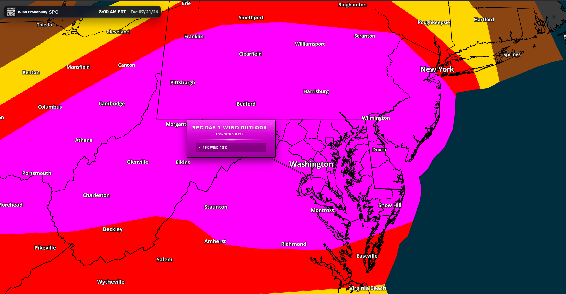

An elevated risk for severe thunderstorms and flash flooding will continue across the Mid-Atlantic through Wednesday, with the greatest threat expected Tuesday afternoon and evening.
A strong upper-level disturbance will move into the Northeast and Mid-Atlantic later Tuesday, providing the atmospheric energy needed for several rounds of showers and thunderstorms. A warm front lifting northward across the region will bring increasingly humid air, followed by a cold front approaching from the west later in the day and Tuesday night.

Scattered showers and thunderstorms may initially develop Tuesday morning, particularly north and west of Interstate 95. These early storms should move relatively quickly, which may limit the flooding threat during the morning hours.
Conditions are expected to become increasingly favorable for stronger thunderstorms during the afternoon and evening. Dew points will rise behind the warm front, and any periods of sunshine could allow instability to build rapidly.

Thunderstorms are expected to initially develop west of the region before organizing into clusters or broken lines as they move eastward. Damaging straight-line winds will be the primary severe weather hazard, especially if storms develop bowing segments capable of producing widespread wind gusts.

A few stronger storm cores could also produce large hail. There will also be a risk of isolated tornadoes, particularly with any discrete storms that interact with the warm front. The position and speed of the front will play an important role in determining where the greatest tornado threat develops.
The severe weather risk may continue into Tuesday evening as instability remains in place. Multiple storm clusters and competing outflow boundaries could create a complicated storm pattern, increasing the possibility of repeated thunderstorms over some locations.
Significant Flash Flooding Concern
In addition to severe weather, thunderstorms will be capable of producing extremely heavy rainfall.

Deep tropical moisture will move northward behind the warm front, with precipitable water values increasing to between 2 and 2.25 inches. These moisture levels will allow stronger thunderstorms to produce rainfall rates of 1 to 3 inches per hour.

Some communities could receive between 2 and 4 inches of rain, while nearby areas may receive considerably less. The highest totals will depend on where thunderstorms repeatedly move across the same locations.
Urban areas, poor-drainage locations and communities that have received heavy rain in recent days will be especially vulnerable. Portions of northern New Jersey and the Philadelphia metropolitan area remain saturated following recent rainfall, increasing the potential for rapid runoff and flash flooding.
A Flash Flood Watch remains in effect through Tuesday night, with the main flooding threat expected during the afternoon and evening.
Storm Threat Shifts South Wednesday

The cold front will gradually move south and east Wednesday, but showers and thunderstorms may continue as additional upper-level disturbances cross the region.
The greatest thunderstorm coverage is expected from southern New Jersey into Delmarva, although storms could briefly extend back toward the Interstate 95 corridor.

Damaging wind gusts will remain the main severe weather threat Wednesday. The highest combination of instability and wind shear is expected across Delmarva and areas farther south, where a somewhat greater severe thunderstorm risk may develop.
Locally heavy rainfall and isolated flash flooding will remain possible, but the overall flooding threat should be lower than Tuesday as the front and deepest moisture shift toward the coastal plain.
Once the cold front moves offshore later Wednesday, much drier weather is expected to arrive Thursday and Friday. The quieter pattern may continue into the weekend.