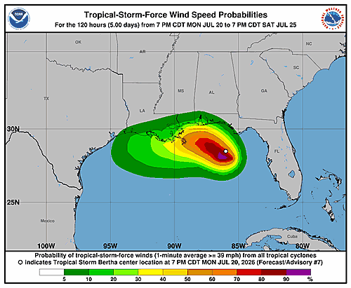

The National Hurricane Center issued its latest forecast discussion Monday afternoon for Tropical Depression Two, a slow-moving storm system in the Gulf of Mexico that forecasters say could gradually strengthen into a tropical storm over the next day or two.
According to the 4:00 PM CDT update, an aircraft flying into the depression measured a minimum central pressure of 1,005 millibars and maximum flight-level winds of 34 knots. Satellite data and additional wind measurements confirmed winds were still below tropical storm strength, keeping the system’s initial intensity at 30 knots — just shy of the 35-knot threshold needed to be classified as a tropical storm.
The storm’s center has been moving erratically throughout the day, but its general motion is toward the northwest at about 3 knots. Forecasters say the depression is caught between two mid-level high pressure ridges — one to its northwest over the central United States and one to its southeast near the Bahamas. As the U.S. ridge strengthens and pushes eastward, it is expected to become the dominant steering force for the storm.
Most forecast models agree the system will drift slowly northwestward to west-northwestward for about 36 hours before turning more toward the west. However, there is some disagreement among models about how close the center will get to the northern Gulf Coast and how sharply it will turn westward. The updated forecast track sits slightly north of the previous one. Forecasters noted that models such as the ECMWF and Canadian models suggest the system could move inland along the northern Gulf Coast.
Strong northeasterly wind shear is expected to give the storm an uneven structure, with the majority of rainfall and much of the wind occurring south of the center rather than in a typical symmetrical pattern around the eye.
Forecasters expect the depression to intensify to a peak of 45 knots — tropical storm strength — around the 36-hour mark. After that, increasing wind shear is expected to disrupt the storm’s vertical structure, halting intensification and causing it to weaken. The system is forecast to degrade to a remnant low by 120 hours, with a possibility it could dissipate altogether between 72 and 120 hours due to shear and interaction with land.
The National Hurricane Center issued the following key messages with Monday’s forecast:
The depression is expected to gradually strengthen and could bring tropical storm conditions to portions of the Gulf Coast from the Florida Panhandle westward to southeastern Louisiana on Tuesday and Wednesday.
A Storm Surge Watch is in effect for the Alabama, Mississippi, and southeastern Louisiana coasts, where a life-threatening storm surge is possible.
Interests elsewhere in Louisiana and Texas should monitor the storm’s progress, as additional watches could be issued for parts of those areas Monday night or Tuesday.
Flash flooding will be possible through Friday along the Gulf Coast and nearby inland areas from western Florida north of Fort Myers to the Middle Texas Coast, including southern portions of Alabama, Mississippi, and Louisiana.
This forecast was prepared by Forecaster Beven at the National Hurricane Center.