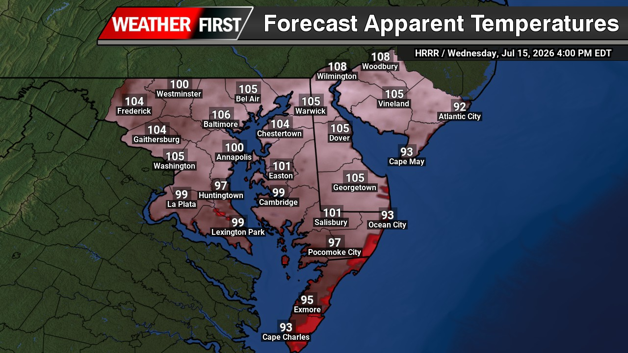
Dangerously hot and humid conditions will peak across the Mid-Atlantic today as above-normal temperatures continue through the end of the week. Extreme Heat Warnings and Heat Advisories are in effect across the entire forecast area, with heat index values expected to reach dangerous levels during the afternoon.

Strong upper-level high pressure positioned to the southwest, combined with warm westerly flow, will push temperatures into the middle and upper 90s across most of the region. Some communities, particularly along and southeast of the Interstate 95 corridor, could approach or briefly reach 100 degrees.

Increasing humidity will make conditions feel even hotter. Heat index values are forecast to range from 100 to 109 degrees across much of the area, with the highest readings expected from northern Delaware and the Philadelphia region southward through Delmarva and portions of southern New Jersey.
Even coastal communities will receive limited relief. A westerly wind of 10 to 15 mph should prevent the afternoon sea breeze from moving very far inland. Temperatures along the Delaware Beaches and New Jersey Shore could still climb into the middle and upper 90s, with heat index values near 100 to 105 degrees.
While today’s heat will be dangerous, it is not expected to reach the same magnitude or duration as the extreme heat experienced at the beginning of July. Humidity levels will also be slightly lower, and the most intense conditions should be limited to one day.

Canadian wildfire smoke is not expected to significantly reduce temperatures today. Forecast guidance indicates the region may remain between the thickest elevated smoke plumes, allowing temperatures to rise despite some haze remaining in the sky.
A weak cold front will move into the area tonight, helping lower temperatures and dew points slightly. Thursday will remain hot, especially along and southeast of Interstate 95, where heat index values could still reach the upper 90s or lower 100s.

Additional Heat Advisories may eventually be needed Thursday across southern portions of the region, although confidence remains limited. Another plume of wildfire smoke could reduce sunshine and suppress temperatures enough to keep heat index values below advisory criteria.
More noticeable relief from the humidity is expected Friday as drier air moves southward. Temperatures may still reach the lower and middle 90s in some areas, but lower dew points should make conditions feel less oppressive.
Residents should limit strenuous outdoor activity during the hottest part of the day, drink plenty of water, wear lightweight clothing, and check on elderly relatives and neighbors. Children and pets should never be left inside a parked vehicle, even for a brief period.