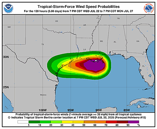

Tropical Storm Bertha came ashore in southeastern Louisiana earlier Wednesday, and forecasters at the National Hurricane Center say the storm’s center has since become harder to pinpoint. The system appears to have drifted slightly southwestward, putting it close to the south Louisiana coastline.
Most of the storm’s heavy rainfall and thunderstorm activity is concentrated south and southwest of the center, out over the northern Gulf of Mexico. That positioning is being driven by persistent north-northeasterly vertical wind shear, which has left the storm’s overall cloud pattern disorganized and stretched from southwest to northeast. The storm’s maximum sustained winds remain at 40 knots — about 45 miles per hour — with those strongest winds occurring primarily over the Gulf waters.
Over the past several hours, Bertha has been tracking slightly south of due west, with its current motion estimated at 260 degrees at 10 knots. A large, powerful high-pressure system sitting over the south-central United States is the main force steering the storm. Bertha is expected to ride along the southern edge of that high-pressure area over the next day or two.
Forecasters say the storm should briefly move back over the northwestern Gulf waters on Thursday before crossing the upper Texas coast later that day and then pushing inland into Texas. The official forecast track has been shifted slightly south compared to the previous prediction, largely because the storm’s center ended up a bit farther south than anticipated. The updated track closely follows the HCCA consensus guidance.
Significant re-intensification is considered unlikely. The storm is expected to remain surrounded by dry air at mid-levels and continue to battle strong wind shear through Thursday. The official intensity forecast leans toward the higher end of what the models suggest, near the SHIPS model prediction.
The National Hurricane Center issued the following key messages with this advisory:
Tropical storm conditions are expected to spread westward along the northern Gulf Coast from Mississippi to southwestern Louisiana — including the greater New Orleans area — Wednesday night and into Thursday. Portions of the upper Texas coast can also expect tropical storm conditions on Thursday.
A Coastal Flood Warning is in effect for the Mississippi and Louisiana coastlines, where moderate coastal flooding is anticipated.
Isolated flash flooding remains possible along the Texas Gulf Coast and South Texas through Thursday night.
Forecast positions show the storm at 29.4°N, 91.1°W with 40-knot winds at the initial time, moving to near 29.2°N, 92.8°W by Thursday morning, then reaching the Texas coast near 29.1°N, 95.6°W by Thursday evening with winds down to 35 knots. By Friday morning, the system is expected to have weakened to a post-tropical remnant low, and it is forecast to dissipate entirely by Saturday. This advisory was issued by Forecaster Pasch.