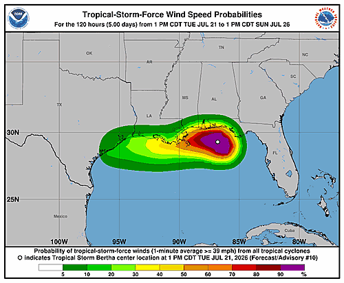

The National Hurricane Center issued its latest forecast discussion for Tropical Storm Bertha on Tuesday afternoon, painting a picture of a storm under stress but still capable of causing significant impacts along the northern Gulf Coast.
Forecasters say Bertha remains a sheared tropical storm, meaning strong northerly winds high in the atmosphere are pushing the storm’s deep cloud activity away from its center. The low-level center of circulation is currently exposed, with bursts of heavy thunderstorm activity displaced to the south. Satellite and scatterometer data collected around 1520 UTC revealed the storm’s tropical-storm-force wind field is larger than previously thought, prompting forecasters to expand the wind radii in their estimates.
Surface observations confirmed that tropical-storm-force winds had already reached some coastal sections of the Florida Panhandle. The storm’s central pressure has stabilized at around 995 millibars, and maximum sustained winds are currently estimated at 50 knots — about 60 miles per hour — based on earlier aircraft reconnaissance data. Forecasters acknowledged that estimate could be slightly high, and an Air Force Reserve Hurricane Hunter aircraft is scheduled to fly through the storm tonight to get a better read on its intensity.
After briefly tracking northward earlier Tuesday, Bertha appears to have shifted back to a northwestward motion, moving at roughly 5 knots. A mid-level ridge of high pressure over the central United States is expected to build eastward on Wednesday, becoming the primary force steering the storm. That steering pattern is projected to push Bertha on a generally westward track, bringing the center near or along the northern Gulf Coast and toward southeastern Louisiana by Wednesday.
What happens after that remains uncertain. The GFS and UKMET computer models suggest the storm’s center could redevelop off the Louisiana coast late Wednesday, while the ECMWF and Canadian models lean toward the storm moving inland and steadily weakening. Forecasters also noted that track guidance this cycle ran faster than before, and the official forecast was adjusted to reflect a quicker pace between the 24- and 60-hour timeframes.
Given Bertha’s current structure and the persistent wind shear battering the storm, additional strengthening is considered unlikely. The official forecast calls for gradual weakening over the next two to three days, consistent with the majority of intensity models. However, forecasters caution the storm could fall apart into a trough of low pressure over southern Louisiana sooner than the forecast currently suggests.
Tropical Storm Watches and Warnings have been extended westward along the Louisiana coast based on the latest forecast track.
Key Messages from the National Hurricane Center:
1. Tropical storm conditions are expected to spread westward along portions of the northern Gulf Coast — from the Florida Panhandle to southeastern Louisiana, including the Metro New Orleans area — through Wednesday night. Tropical storm conditions are also possible along the southwestern Louisiana coast Wednesday night into Thursday.
2. A Coastal Flood Warning is in effect for the Mississippi and Louisiana coastlines, where moderate coastal flooding is anticipated.
3. Residents in far western Louisiana and along the Upper Texas Coast should keep a close eye on this system, as additional watches or warnings may be issued for those areas.
4. Isolated flash flooding will be possible through Thursday along the Gulf Coast, from the western Florida Panhandle into southern Louisiana.
The storm is forecast to dissipate by Saturday, July 25. This discussion was prepared by Forecaster Reinhart.