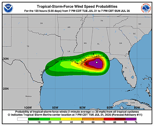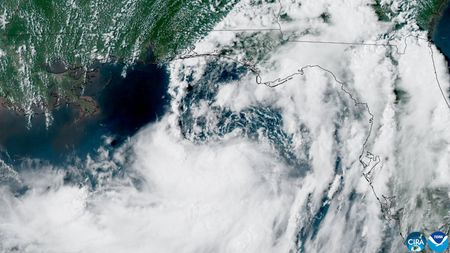

Tropical Storm Bertha was making its presence known across the northeastern Gulf of Mexico on Tuesday, spreading tropical-storm conditions along portions of the northern Gulf Coast while a separate weather system threatened to unleash severe thunderstorms and heavy rainfall across the northeastern United States.
As of 7 p.m. CDT Tuesday, the National Hurricane Center placed Bertha approximately 105 miles south-southeast of Mobile, Alabama. The storm — the second named storm of the Atlantic hurricane season — was carrying maximum sustained winds of 60 mph and drifting westward at just 6 mph. Forecasters expected Bertha to come ashore in Louisiana sometime late Wednesday.
A gradual reduction in storm strength was anticipated from Wednesday through Friday.
Tropical storm warnings were in effect from Florida’s Panhandle westward through coastal Louisiana, covering the greater New Orleans area and Lake Pontchartrain. The National Hurricane Center cautioned summer beachgoers about hazardous surf and dangerous rip currents.
Energy company Chevron announced it was halting production at its Petronius facility in the Gulf as a safety measure, relocating all associated workers to shore ahead of the storm. The company also said nonessential staff were being moved off its two other Gulf platforms.
The primary danger from Bertha was expected to come in the form of heavy rain and localized flooding. Forecasters called for several inches of rainfall along parts of the central Gulf Coast, stretching from western Florida to southern Louisiana, through Thursday.
Further north, the National Weather Service issued warnings for numerous severe thunderstorms expected to develop from the Ohio Valley into the Mid-Atlantic and Northeast states. Forecasters said widespread damaging wind gusts were likely, and some areas could see tornadoes as the storm system pushed eastward.
A tornado watch had been issued for New York City on Tuesday night but was later lifted. Tornadoes remained possible in connection with severe storms across the Tennessee Valley and into the Mid-Atlantic region, the weather service said.
The storm system was also expected to drop heavy rainfall across parts of the Northeast, raising the risk of flash flooding — particularly in areas already soaked by recent wet weather.