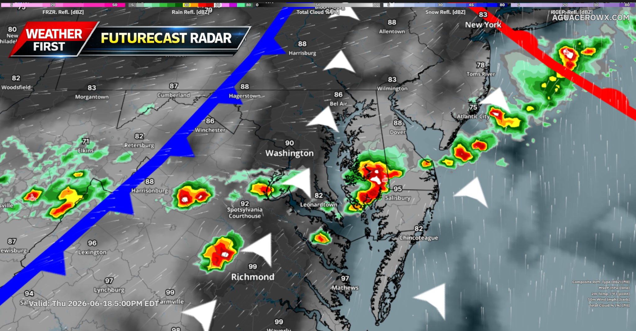

DELMARVA — Residents across the Delmarva Peninsula should prepare for a potentially active weather day Thursday as hot, humid conditions combine with a powerful storm system capable of producing severe thunderstorms during the afternoon and evening hours.
A strong upper-level disturbance will move across southern Canada and New England on Thursday. While the center of the storm system will remain well north of the region, its influence will extend southward into the Mid-Atlantic, creating an environment favorable for severe weather development.

A warm front is expected to lift north through the region during the early morning hours, placing Delmarva firmly within a warm and increasingly humid air mass. Temperatures are forecast to surge into the upper 80s and lower 90s by afternoon, while dew points climb into the upper 60s and lower 70s. The combination will push heat index values into the low and middle 90s, creating uncomfortable conditions before storms develop.

The primary concern arrives later in the day as a cold front approaches from the west. Strong atmospheric winds associated with the system will overspread the region, creating an environment capable of supporting organized thunderstorms. Forecast data indicates winds exceeding 60 mph just a few miles above the ground, resulting in deep-layer wind shear values of 50 to 55 knots which is more than sufficient to organize storms into fast-moving clusters or line segments.
Despite only moderate instability expected across the region, enough daytime heating and moisture should be present to support scattered thunderstorm development during the afternoon and evening hours.
That is what we are looking at right now. An atmosphere that will not need many storms to become severe. The combination of strong wind fields and increasing instability could allow any thunderstorm that develops to quickly intensify.

The primary threat appears to be damaging straight-line winds capable of downing trees and power lines. Some storms may also produce hail due to the strength of the winds aloft. Tornado potential currently appears limited, though it cannot be ruled out entirely if storms become more organized.
There remains some uncertainty regarding the overall coverage of storms. Computer models continue to differ on the timing of the strongest upper-level disturbance. If it moves through earlier in the day, sinking air behind the system could somewhat limit thunderstorm development. However, even in that scenario, the approaching cold front should still be capable of triggering isolated to scattered severe storms.
The highest concern for severe weather currently appears to be from Thursday afternoon through the early evening hours, especially across southeastern Pennsylvania, southern New Jersey, and much of Delmarva where stronger heating and richer moisture are expected.

Another factor to watch will be the heat and humidity ahead of the storms. Temperatures approaching 90 degrees combined with tropical moisture will make it feel several degrees hotter, with heat index values reaching the low to mid 90s during the afternoon.

In addition to the thunderstorm threat, residents should prepare for a notably windy day. Southwesterly winds will increase throughout the afternoon, with frequent gusts between 25 and 35 mph expected across the peninsula. While widespread wind advisory criteria are not anticipated, the gusty conditions may make outdoor activities challenging and could contribute to scattered tree damage if severe storms develop.
As of now, that is what we are looking at for Thursday: a hot, humid, and breezy day with the potential for scattered severe thunderstorms capable of producing damaging winds and isolated hail during the afternoon and evening hours. While questions remain regarding exactly how widespread storm coverage becomes, residents across Delmarva should stay weather aware and monitor the latest forecasts as Thursday approaches.