
For a long time, scientists have been puzzled by a curious imbalance between Earth’s two polar regions — Antarctica froze over roughly 34 million years ago, yet the Arctic didn’t develop a permanent ice cap until about 25 million years later. Now, a new study may finally have the answer.
Researchers examined the ancient landscape of the Antarctic region and used computer simulations to trace how its terrain changed across tens of millions of years. What they discovered was that a slow but powerful geological force deep within the Earth drove the rise of a mountain range in eastern Antarctica — and that uplift ultimately crossed a critical elevation point that allowed glaciers to grow and permanent ice to take hold.
The outcome was the formation of the vast East Antarctic ice sheet at a time when global temperatures were roughly 9 degrees Fahrenheit — or 5 degrees Celsius — warmer than they are today. This gave the South Pole its ice cap long before a gradual global cooling trend eventually allowed ice to become permanently established around the North Pole. The East Antarctic ice sheet was already in place by the beginning of a period in Earth’s history known as the Oligocene epoch, which came after the Eocene epoch.
Long before any of this happened, Antarctica was once part of a massive Southern Hemisphere supercontinent known as Gondwana, which also included what are now Africa, South America, Australia, Arabia, and the Indian subcontinent. Over time, through the process of plate tectonics — the slow, constant movement of large sections of Earth’s outer shell — these landmasses broke apart and drifted to where they are today.
“Our study shows that an ancient geological process that started more than 160 million years ago during the continental breakup of Africa and Antarctica and played out over many tens of millions of years determined when and where Earth’s major ice sheets could form during the Eocene-Oligocene transition, approximately 34 million years ago,” said geoscientist Thomas Gernon of the University of Southampton in England, who co-led the study published Thursday in the journal Science.
Gernon noted that this transition marked a shift from Earth’s warm “greenhouse” climate to the cooler period the planet is in today.
Antarctica stayed connected to Australia and South America for tens of millions of years after Africa broke away, before eventually separating from those continents as well.
The geological force at the heart of this story is known as mantle waves — slow-moving disturbances that originate deep inside the Earth and are set off when continents split apart.
“These waves can remove dense rock from the underside of tectonic plates, making the continents lighter and causing them to rise, ultimately forming high ground such as plateaus and mountain ranges,” Gernon explained.
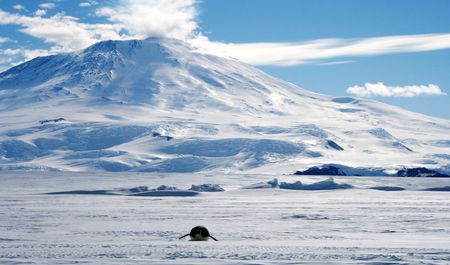
As these mantle waves passed beneath Antarctica, they triggered the formation of a large elevated plateau topped by the Gamburtsev Mountains — a range located in the central part of eastern Antarctica. Those mountains reach heights of up to about 11,120 feet, or roughly 3,390 meters, though today the entire range lies buried beneath the world’s largest ice sheet.
The researchers concluded that erosion and the upward push caused by mantle waves gradually raised the landscape to elevations high enough for ice to stabilize, even during a period of global warmth.
“Our study underscores the importance of the interaction of changing climate and changing topography,” said Thea Hincks, a geoscientist at the University of Southampton and co-leader of the study.
Gernon said that toward the end of the Eocene, the elevation needed to sustain permanent ice in Antarctica was roughly between 4,920 and 6,560 feet — or about 1.5 to 2 kilometers. The study’s models showed that by around 45 million years ago, large portions of eastern Antarctica had already risen above that threshold.
“Just as temperatures fall as we climb a high mountain, higher elevations are more likely to retain snow year-round. We found that before Antarctica became glaciated, the area of the Gamburtsev Mountains above the critical elevation for sustaining ice increased dramatically. By about 34 million years ago, nearly 90% of the region lay above this threshold, compared with only about one-third 60 million years ago,” Gernon said.
The Arctic tells a very different story. Glaciers there have come and gone over the past 50 million years, but large, stable ice sheets didn’t form until less than 10 million years ago. A key reason: there is no actual landmass at the North Pole. It sits in the middle of the Arctic Ocean, meaning there was no terrain available to reach the elevation threshold needed to support permanent ice earlier in history.
“The climate needed to get cooler via reduced atmospheric carbon dioxide concentrations before permanent ice could form at lower elevations,” Gernon said.