
PAGE, Ariz. — Matt Barrett has watched Lake Powell shrink almost every year since around 2013, when he first began making regular visits to the reservoir straddling the Utah-Arizona border. A handful of unusually snowy winters helped the water bounce back temporarily, but this year offered no such relief.
“We need another one of those fast,” Barrett said. “A few of those fast.”
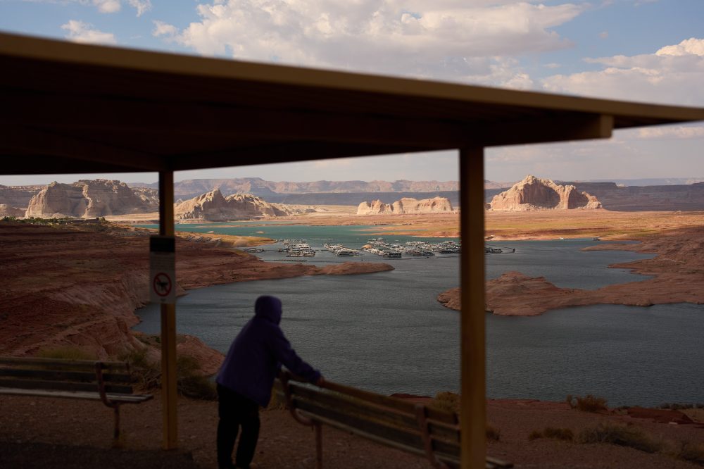
The dramatically low water has made it increasingly difficult for visitors like Barrett to get their boats on the lake, since “all the other boat ramps are dried up.” Barrett, who planned to spend several days boating and camping at the lake with his wife, said the situation is “kind of a big deal when the water is low, especially for loading and unloading.”
Lake Powell — the Colorado River’s second-largest reservoir in the country — is steadily disappearing. A historically dry winter combined with extreme heat, plus decades of overuse, persistent drought, and climate change, are pushing the lake toward near-record low levels. Marinas at this major tourist destination have been forced to respond: boat ramps have shut down or been relocated, new ones are under construction, and some marina facilities have been temporarily moved to reach deeper water.
“The Colorado River is in full-blown crisis mode,” said John Berggren, regional policy manager with Western Resource Advocates, an environmental nonprofit.
Despite the alarming conditions, marina operators say there is still enough water on Lake Powell for recreational use.
The reservoir is currently sitting at roughly 23% of its capacity and is approximately 33 feet — about 10 meters — away from the threshold below which hydropower generation becomes impossible. The lake could break its all-time record low as early as this coming September.
When combined with Lake Mead — the nation’s largest reservoir, located downstream — the two bodies of water are at their lowest combined levels in nearly 70 years. According to a recently published paper by a team of academics and retired water officials, the last time the combined storage was this low was in May 1957, when the Glen Canyon Dam that holds back Powell was still under construction. Powell itself began filling in 1963.
“There’s less water in the two reservoirs than there has ever been at any time in the history of Lake Powell even existing,” said Jack Schmidt, lead author of the paper and director of the Center for Colorado River Studies at Utah State University. Together, Mead and Powell hold just under 60% of all water stored across the basin. “It is a reminder that we are significantly failing in our ability to control and reduce our basin-wide consumptive use,” Schmidt added.
The paper’s authors caution that both reservoirs will keep declining until winter snowpack starts melting next spring. “Every day going forward … a record low will likely be set,” they wrote, calling it “a significant moment in the evolving Colorado River water supply crisis.”
The Colorado River supplies water to farmers, industries, wildlife, hydropower systems, and more than 40 million people spread across seven U.S. states, tribal nations, and Mexico. To help keep Powell above critical elevations, up to 1 million acre-feet — roughly 1.23 billion cubic meters — of water is being routed from the Flaming Gorge Reservoir upstream through next April. The federal government is also expected to soon release its preferred short-term proposal for how seven states — California, Nevada, Arizona, Colorado, New Mexico, Wyoming, and Utah — should divide the river’s shrinking supply. Current water-sharing guidelines expire this year, and the states have yet to reach a long-term deal.
Near Page, Arizona, a pale mineral ring etched into the canyon walls marks where the water once stood at its peak. Visitors now travel by golf cart some 20 feet — roughly 6 meters — below a dock that was once at water level.
Lake Powell is one of eight western reservoirs the Bureau of Reclamation has identified as being at or near all-time low levels.
Elephant Butte State Park in New Mexico — the largest reservoir along the Rio Grande, a separate river system from the Colorado — is at approximately 2% of its capacity. Critically low levels forced two boat ramps to close in June, and crews must now use heavy machinery every day to clear sediment from the main ramp just to allow boats to launch.
Richard Holcomb, mayor of Elephant Butte, said the area is seeing a noticeable drop in both tourists and regular visitors.
“Many of our weekend homeowners have decided to look elsewhere for water opportunities,” he said. “This hits our gross receipts tax, which is a major source of our revenue” — money that helps fund local infrastructure improvements.
New Mexico water managers are also facing pressure to meet delivery obligations to Texas under a settlement recently approved by the U.S. Supreme Court. Researchers have warned that unsustainable use of the Rio Grande — which starts in Colorado and flows into Mexico — threatens water security for millions of people.
The National Park Service is cautioning visitors that low water levels have created new hazards on the water, including newly exposed shorelines, submerged obstacles, and channels that are narrower or constantly shifting. Current water levels are so low that houseboats and small motorized watercraft cannot safely launch from most ramps, several of which have already been closed. Fewer available ramps also mean longer wait times and increased congestion.
Multiple infrastructure projects are either in development or already underway to preserve water access as levels continue to fall.
At Antelope Point Marina, plans call for spending approximately $81 million to extend a boat ramp so the lake can still be accessed even if water drops to as low as 3,520 feet — about 1,073 meters — above sea level. Kenneth Runnels, chief administrator with Antelope Point Holdings, said the project will be completed and operational next year. “We’ll be able to launch no matter what,” he said.
In another part of the lake, the marina at Bullfrog Bay is being relocated to deeper water, with a new boat ramp and marina access to be built at an estimated cost of $73.4 million. Meanwhile, the Wahweap Stateline ramp is being continuously extended downward. “As the water goes down, they continue to pour concrete to make it go deeper and deeper,” Runnels said.
The low water is taking a financial toll, Runnels acknowledged. Longtime visitors and boat owners are still making the trip, but first-time tourists are staying away — a problem that “doesn’t just affect us. That affects the whole town of Page,” he said.
Even so, Runnels noted that the Antelope Point Marina currently sits in 338 feet — about 103 meters — of water, and that recreation remains viable.
“There’s plenty of water to recreate. The problem isn’t the recreation. The problem is the access, which is going to get fixed by the improvements in the ramp,” he said.