Motorists traveling on Interstate 495 northbound should expect to see debris removal crews working along the roadway shoulder today between the Claymont and Edgemoor areas.
According to DelDOT traffic officials, the trash cleanup operation began this morning and is expected to wrap up by 12:00 PM. The work is taking place on the shoulder of the northbound lanes in that stretch of the highway.
Drivers are advised to use caution when passing through the work zone and to be aware of crews and equipment operating near the travel lanes.
Students interested in pursuing agricultural studies can now apply for financial assistance through the Delaware Farm Bureau’s scholarship program, which provides awards of up to $2,500 per recipient.
The funding comes from collaborative efforts between the Delaware Farm Bureau Women’s Committee, the Young Farmers & Ranchers Committee, and Farm Bureaus across all three counties in the state.
These committees work year-round to raise money for the scholarship fund. The Women’s Committee contributes earnings from operating their food stand during the Delaware State Fair, while the Young Farmers & Ranchers group organizes fundraising activities including their annual Antique Tractor Pull event in July.
Connor Vincent, who serves as State Chair for the Young Farmers & Ranchers, expressed enthusiasm about the program’s mission. “We’re grateful for every opportunity to invest in the next generation of agricultural leaders,” Vincent said. “Supporting students through these scholarships is one of the ways our committee helps develop the future of agriculture.”
Students interested in applying can find the necessary forms on the organization’s website at defb.org/about-us/scholarships-and-programs/scholarships/. The deadline for submitting completed applications is Friday, May 1, 2026.
Additional details about the scholarship program are available by visiting defb.org or calling the Delaware Farm Bureau directly at 302-697-3183.
Delaware Department of Transportation crews are actively removing debris from Interstate 495 northbound this morning, working along the shoulder between the Claymont and Edgemoor areas.
The cleanup operation began earlier today and is expected to wrap up by noon, according to DelDOT traffic reports. The debris removal work is being conducted on the shoulder of the highway to minimize disruption to traffic flow.
Motorists traveling through the area should exercise caution and be prepared for possible minor delays as crews complete their work. The operation affects the northbound lanes of I-495 in the specified section between Claymont and Edgemoor.
Devastating tornadoes ripped through Illinois and Indiana communities Tuesday evening, claiming two lives and leaving a trail of destruction as additional severe weather systems continued to threaten the region Wednesday.
Newton County Sheriff Shannon Cothran urged residents to stay away from affected areas during a video briefing recorded in front of a demolished residence in Lake Village, a small northwestern Indiana town. “Please do not come here. Do not try to help right now,” Cothran warned.
Lake Township Fire Department spokesperson Laurie Postma confirmed the two fatalities during a Wednesday press conference attended by the sheriff, state police, and local officials. The victims’ identities have not been disclosed.
Postma reported that fewer than 10 individuals sustained injuries from Tuesday’s severe weather, which also brought down numerous trees and electrical lines throughout the area.
An apparent tornado demolished several residences in the community, according to Indiana State Police Cpl. Eric Rot, who confirmed injuries but could not specify exact numbers or medical conditions.
Local paramedic David Ferris, who resides in Lake Village near the impacted zone, described sheltering with his wife and dogs in their downstairs bathroom during the storm. “We rode it out in our downstairs bathtub,” Ferris explained to The Associated Press. While they escaped injury and only lost electricity, Ferris later assisted in rescue operations, treating victims with various cuts, scrapes, and head injuries.
“We had another house where a guy crawled out,” Ferris recounted. “He was having some trouble breathing because he was covered in house insulation.”
Ferris observed extensive damage including the complete destruction of the local Family Dollar store and a gas station located across the street, along with numerous large trees that were completely uprooted.
The National Weather Service warned that severe storms bringing heavy rainfall and hail across Midwest regions posed continued threats of powerful tornadoes, destructive winds, and exceptionally large hail from the southern Plains through the southern Great Lakes. Tornado watches remained active Wednesday morning for portions of Illinois, Indiana, Kentucky, and Ohio.
Multiple tornadoes developed throughout northeastern Illinois and northwestern Indiana, though Storm Prediction Center meteorologist Andrew Lyons noted that precise counts await completion of official damage assessments.
Illinois Governor JB Pritzker acknowledged the storm damage in a social media post, stating he had received briefings on the situation. “Keeping in our thoughts all Illinoisans impacted by the severe weather — we’ll be here to help them recover,” he wrote.
A tornado touched down near Kankakee fairgrounds, approximately 57 miles south of Chicago, before moving northeast into Aroma Park where it produced widespread damage, the Kankakee County Sheriff’s Office reported. No injuries were documented in that area.
“I want to remind area residents to check on their neighbors and loved ones but to avoid unnecessary travel, if at all possible,” Kankakee County Sheriff Mike Downey stated.
Social media footage captured the twister moving across agricultural fields near an airport while vehicles gathered along nearby roadways.
Weather officials placed over 2 million Americans under moderate severe weather risk across Illinois and Indiana. An additional nearly 22 million people faced slightly lower risk levels in an expanded zone encompassing Chicago, Fort Worth, Texas, and Oklahoma City, Oklahoma.
SALISBURY, Md. – Salisbury residents have an opportunity to dispose of large household items at no charge during a special collection week scheduled for March 16-20, 2026. The city requires advance registration, with a deadline of noon on Friday, March 13.
Homeowners interested in participating should contact the Department of Field Operations at 410-548-3177 to arrange their pickup. Callers need to mention they want the complimentary bulk collection service for the March 16 week and provide their regular garbage pickup day. The city warns that late requests may not be fulfilled.
Residents who encounter voicemail should leave a complete message with their full name, contact number, home address, regular collection day, and a description of items requiring pickup.
The program includes several restrictions:
Maximum of three large items per household.
Items containing fabric, including mattresses and box springs, require plastic wrapping secured with tape.
The service excludes appliances and building materials such as lumber, bathroom fixtures, toilets, and playground equipment.
Apartment and condominium complexes must handle their own bulk disposal as city services don’t cover multi-unit buildings.
Large items cannot go in regular trash or recycling containers.
All materials must be placed at the curb by 6:00 a.m. on the resident’s normal collection day, with overnight placement recommended.
Questions about the program can be directed to the Department of Field Operations at 410-548-3177.
Motorists using Chapel Street in Newark are dealing with traffic restrictions today as construction crews continue their work in the area.
The Delaware Department of Transportation reports that the right lane is currently blocked for northbound traffic on Chapel Street in the stretch between Old Baltimore Pike and Interstate 95.
The lane restriction is scheduled to remain in place until 3 PM today, according to DelDOT’s traffic incident reporting system.
Drivers are advised to allow extra travel time and use caution when passing through the construction zone. Traffic may be moving more slowly than usual during peak hours.
Salisbury municipal workers will tackle a sinkhole repair project Wednesday, October 8th, as part of the city’s continuous efforts to upgrade and maintain its sewer infrastructure. The Waterworks Utilities Division will address the damaged roadway in the 600 block of Monroe Street.
The repair operation will require shutting down Monroe Street to through traffic from Washington Street to Prince Street while crews work to fix and fill the sinkhole. City officials anticipate wrapping up the project by approximately 3:30 p.m., assuming no unexpected complications arise.
Utility location services and Central Alarm systems have received advance notification of the planned work.
Motorists in Wilmington are dealing with traffic delays on West Avenue today as construction crews have shut down one northbound lane.
The Delaware Department of Transportation reports that the lane closure affects the stretch of West Avenue running between Delaware Avenue and Scanlon Street. Officials say the construction work is expected to wrap up by 3 PM this afternoon.
Drivers are advised to allow extra travel time or seek alternate routes while the work continues. DelDOT continues to monitor the situation and will reopen the lane once construction activities are completed.
Students at Warner Elementary School in Wilmington got a firsthand look at agriculture career possibilities when Liz Harrison visited their Junior Achievement Exploration Fair. Harrison, who serves as Chair of New Castle County Young Farmers and Ranchers, works as a farm insurance agent and spoke with students about her professional journey in the agricultural sector.
The exploration event featured multiple stations where business professionals and volunteers from various Delaware industries shared insights about their work. Harrison joined other community members in broadening students’ perspectives on potential career paths they might pursue in the future.
Young learners peppered Harrison with numerous inquiries about agricultural work and farming life. She detailed how farmers maintain demanding schedules with unpredictable hours, explaining that her role as their insurance representative requires her to remain accessible whenever clients require assistance. When students questioned how to recognize authentic food products, Harrison discussed whole food concepts and locations where they’re available, noting that farmers markets along with grocery store produce, meat, and dairy departments provide excellent opportunities to support area farmers while selecting nutritious options.
The interaction proved meaningful for Harrison, who appreciated learning about the students’ personal interests and career dreams. “I always ask kids what they want to change about their world when they grow up and the responses blew me away,” she said. “Our youth have big aspirations for their future!” Additional details about Junior Achievement of Delaware can be found at https://delaware.ja.org/, while Delaware Farm Bureau information is available at www.defb.org.
Two Delaware State University women’s basketball players received prestigious conference honors when the Mid-Eastern Athletic Conference revealed its 2026 all-conference selections.
First-year players Amya Scott and Liliana Harrison both earned spots on the MEAC All-Rookie Team, as announced by the conference on March 10th, 2026, from Norfolk, Virginia.
The recognition highlights the exceptional debut seasons both players had with the Hornets women’s basketball program during their freshman campaigns.
Delaware State basketball secured a thrilling 75-70 overtime victory against Morgan State, powered by Miles Webb’s outstanding double-double performance.
Webb’s dominant showing on both ends of the court proved crucial as the Hornets battled through regulation and into the extra period to claim the conference win.
The game showcased Delaware State’s defensive intensity, which became the determining factor in the closely contested matchup. The Hornets’ ability to execute defensively in key moments allowed them to outlast their opponents in the additional five-minute period.
The overtime thriller demonstrates Delaware State’s resilience and ability to perform under pressure as they continue their season. Webb’s exceptional individual effort highlighted a complete team performance that secured an important victory for the Hornets.
Drivers in the area will need to find alternate routes as a section of Reybold Road remains completely impassable due to urgent utility repairs.
The Delaware Department of Transportation reports that both eastbound and westbound lanes are blocked between Salem Church Road and Whitewood Court while crews address emergency utility infrastructure issues.
Motorists should plan for delays and seek alternative routes until the emergency repairs are completed and the roadway can safely reopen to traffic.
Construction has been temporarily suspended on a major immigration detention facility in Maryland after a federal judge sided with state environmental concerns this week.
U.S. District Judge Brendan Hurson issued the restraining order Wednesday, putting work on hold for up to two weeks while the court reviews Maryland’s broader legal challenge to the project.
The facility, situated on 54 acres in Washington County, involves converting an existing warehouse into a detention center with capacity for 1,500 individuals. Federal officials have invested more than $100 million in the project, according to Maryland Attorney General Anthony Brown, who filed the lawsuit in February.
Brown’s legal team contended that the Trump administration bypassed required environmental assessments and failed to seek public comment before moving forward with construction.
In his ruling, Judge Hurson determined the state demonstrated federal officials “likely failed to comply with their obligations under (the National Environmental Policy Act).”
The judge further noted that “Defendants do not appear to have taken a ‘hard look’ at the potential environmental consequences of their plans for the Williamsport Warehouse.”
The Department of Homeland Security, which oversees Immigration and Customs Enforcement, had previously indicated willingness to collaborate with state authorities on expanding detention capacity. However, federal officials have disputed Maryland’s claims that environmental issues are the true basis for the legal action.
The Trump administration’s expanded immigration enforcement efforts have drawn sharp criticism from civil rights organizations, who argue the policies violate constitutional protections and create dangerous conditions for minority communities.
Trump has defended his immigration policies as necessary measures to combat illegal border crossings and enhance national security.
Attorney General Brown celebrated the court decision as a victory for proper legal procedures.
“Though temporary, this ruling stops the construction of this massive immigration detention center while our lawsuit continues to play out in court. We will not let DHS and ICE rush through the proper legal process in their haste to ramp up deportations,” Brown stated.
Delaware Department of Transportation officials have temporarily closed the eastbound left turn lane on Route 40 at the intersection of Porter Road and Salem Church Road.
The lane closure is necessary to accommodate construction activities in the area. DelDOT reports the restriction will stay in place until 5 a.m.
Motorists traveling eastbound on Route 40 should plan alternate routes or expect delays when attempting to make left turns at this location during the closure period.
Delaware Department of Transportation officials have implemented lane closures on westbound Route 40 that will affect traffic flow at two key intersections through early morning hours.
Both right and left turning lanes are currently blocked at the Porter Road and Salem Church Road intersections along westbound Route 40, according to DelDOT’s traffic incident reporting system.
The lane restrictions stem from ongoing construction work in the area and are expected to remain in place until 5 a.m.
Motorists traveling through the area should plan for potential delays and consider alternate routes if possible during the closure period.
Motorists using Interstate 95 northbound are encountering traffic delays due to ongoing construction work that has shut down one lane of travel.
Delaware Department of Transportation reports that construction crews have closed the right lane on northbound I-95 in the stretch between the toll plaza and the welcome center.
Drivers should plan for potential delays and consider using alternate routes if possible while the construction work continues in this area.
Delaware Department of Transportation officials have temporarily shut down the right shoulder along a section of Ingram Branch Road as construction crews continue their work in the area.
The shoulder closure affects the stretch of roadway running from Whiteleysburg Road to Brownsville Road, creating potential delays for drivers traveling through the zone.
Transportation officials indicate the restriction will remain active until 5 PM today, after which normal traffic patterns should resume.
Motorists are advised to use caution when driving through the construction zone and allow extra travel time to reach their destinations.
Delaware State Police are working to determine what caused a deadly head-on collision that took the life of a Pennsylvania man Tuesday afternoon in Hockessin.
The crash happened around 1:30 p.m. on March 10, 2026, along Lancaster Pike just south of Mc Govern Road. According to investigators, a Hyundai Sonata heading north veered across the center line and slammed directly into an oncoming Chevrolet Silverado traveling south.
The Hyundai’s driver, a 65-year-old Landenberg, Pennsylvania resident, was rushed to a nearby hospital where he died from his injuries. Authorities are not releasing his identity until relatives have been contacted.
The Silverado’s operator, a 79-year-old Hockessin man, was also hospitalized but is expected to recover from injuries that are not considered life-threatening.
Traffic was diverted from the area for roughly three hours as emergency crews responded and investigators documented the scene.
The case remains under active investigation by Delaware State Police Troop 2’s Collision Reconstruction Unit. Authorities are asking anyone who saw the crash happen or has information that could help investigators to reach out to Corporal D. McKenna at (302) 365-8486. Tips can also be shared through private messages to Delaware State Police on Facebook or by calling Delaware Crime Stoppers at 1-800-847-3333.
Those affected by sudden loss or crime-related trauma can access support services around the clock through the Delaware State Police Victim Services Unit and Delaware Victim Center. The free helpline is available at 1-800-VICTIM-1 (1-800-842-8461), and assistance can also be requested via email at [email protected].
Delaware State Police have taken a 57-year-old Lewes resident into custody after he allegedly broke into an occupied home and physically assaulted one of the residents during the early morning hours of March 10, 2026.
Law enforcement officers were dispatched to a home in the 19000 block of Plantation Road in Lewes around 2:00 a.m. after receiving reports of an active break-in. Upon arrival, officers encountered residents who were shouting and gesturing toward the direction where the intruder had fled.
Police quickly apprehended the suspect, later identified as Dale Andrews, without any resistance. According to the investigation, Andrews had gained entry to the home by walking through an unlocked door and then physically grabbed a 57-year-old male resident. He fled the scene after being confronted by another person inside the house. The male victim sustained minor injuries during the incident.
Following his arrest, Andrews was transported to Troop 7 for processing. He now faces multiple charges including first-degree burglary of an occupied dwelling causing injury, which is classified as a felony, as well as offensive touching.
After appearing before Justice of the Peace Court 11 for arraignment, Andrews was remanded to Sussex Correctional Institution where he is being held on $20,500 cash bond.
SALISBURY, Md. – The nationally-ranked Salisbury University women’s lacrosse squad delivered a commanding performance against Ohio Northern University Wednesday evening, defeating the Polar Bears 16-7 at Sea Gull Stadium.
The Sea Gulls, currently sitting at No. 5 in national rankings, dominated the game’s final 30 minutes by outscoring their visitors 8-2 throughout the second half. Most impressively, Salisbury completely blanked Ohio Northern during the final quarter, scoring six unanswered goals to seal the victory.
The midweek matchup showcased the Sea Gulls’ offensive firepower and defensive strength as they pulled away from the Polar Bears after what appeared to be a closer contest at halftime.
Motorists traveling eastbound on Pennsylvania Avenue will encounter a lane restriction near Woodlawn Avenue as construction crews continue their work in the area.
According to DelDOT traffic reports, the right lane remains blocked to traffic due to ongoing construction activities. The closure is expected to last until 2 PM today.
Drivers are advised to use caution when approaching the work zone and allow extra time for their commute. Traffic may experience delays as vehicles merge from the closed right lane into the remaining open lanes.
Law enforcement officials in Maryland are preparing for heightened road safety enforcement as St. Patrick’s Day weekend approaches, with state troopers warning drivers to stay alert and avoid dangerous behaviors behind the wheel.
Officers from all 23 Maryland State Police barracks will deploy enhanced patrol operations from Friday, March 13 through Tuesday, March 17, targeting drivers who operate vehicles while impaired, distracted, or aggressively. The specialized State Police Impaired Driving Reduction Effort (SPIDRE) unit will join regular troopers in concentrating on roadways known for frequent alcohol-related accidents. The Maryland Department of Transportation Motor Vehicle Administration’s Highway Safety Office is providing financial support for these enforcement activities.
The comprehensive patrol strategy will span five regions throughout the state:
Eastern Region: Officers stationed at Berlin, Centreville, Easton, Princess Anne and Salisbury will concentrate enforcement activities on primary travel routes, specifically Route 301 and Route 50.
Central Region: Personnel from College Park, Forestville, Golden Ring, Rockville, Waterloo and Westminster stations will maintain highly visible presence on Interstate 495, Interstate 270, and Routes 50, 5 and 301. Westminster officers will coordinate their efforts with both Carroll County Sheriff’s Department and Westminster City Police Department.
Western Region: Troopers based in Cumberland, Frederick, Hagerstown and McHenry will prioritize accident prevention and DUI detection on key highways including Interstate 70, Interstate 81, and Routes 40 and 65.
Northern Region: Law enforcement from Bel Air, JFK Memorial Highway and North East facilities will target locations with documented histories of impairment-related collisions.
Southern Region: Officers from Annapolis, Glen Burnie, La Plata, Leonardtown and Prince Frederick will monitor heavily traveled corridors such as Route 295 and Interstate 695.
For individuals planning to attend St. Patrick’s Day celebrations, police recommend several safety measures: Choose a designated driver before leaving home and hand over vehicle keys to that person. Avoid consuming alcohol if you intend to operate a vehicle. Explore public transit options, taxi services, or ride-sharing applications. Prevent intoxicated friends from getting behind the wheel. Contact emergency services at 911 if you observe suspected impaired driving. Always wear seatbelts and stay focused on driving without texting or using handheld devices.
Those hosting St. Patrick’s Day gatherings should remember their potential legal responsibility if guests they serve alcohol to cause impaired driving incidents. Hosts should provide substantial food options and non-alcoholic drink choices, arrange transportation alternatives in advance for drinking guests, keep local taxi contact information accessible, and confiscate keys from anyone considering impaired driving.
Authorities emphasize the importance of responsible celebration practices and urge all motorists to avoid impaired, aggressive, and distracted driving behaviors during the holiday period.
Rising temperatures are drawing fishing enthusiasts to Maryland’s waterways as spring conditions take hold. Recent trout stockings are delivering excellent fishing opportunities in waters currently open to anglers, while yellow perch are starting their annual spawning migrations and numerous freshwater species are showing increased activity.
Weekly Outlook: March 11-17
Spring indicators are abundant throughout the region – spring peepers are calling, trees are beginning to bud, and crocuses are in bloom. With lengthening days and climbing temperatures, Chesapeake Bay waters continue their gradual warming trend, encouraging gamefish to move toward spawning areas. Monitoring buoy data shows main Bay surface temperatures remaining in the mid-40s, while river temperatures hold steady in the low 50s. Smaller waterways and downwind locations on sunny days will experience faster warming, often reaching temperatures closer to the 50s. These warmer, low-salinity areas will be prime locations for yellow perch as they migrate from their winter refuges in downstream river sections, preparing to spawn in Maryland waters over the coming weeks.
Most Maryland rivers and streams are expected to maintain average flow levels. Water clarity should remain typical for most Maryland sections of the Bay and tributary rivers. Above-average tidal current conditions are anticipated from Sunday through Tuesday due to the new moon arriving March 18.
Upper Chesapeake Bay
The lower Susquehanna River remains stained this week with water temperatures around 44 degrees. Anglers taking advantage of pleasant weather are targeting deeper river sections for yellow perch and blue catfish. Yellow perch fishing involves dropper rigs with small minnows and adequate weight to maintain bottom contact. The ice formation at the North East River entrance has disappeared, allowing anglers to fish shallower areas using lip-hooked minnows near the bottom. Working a lip-hooked minnow slowly across the bottom with appropriate split shot weight proves highly effective for yellow perch, while dropper rigs work best in deeper areas.
Anchoring over deeper holes in the lower Susquehanna provides excellent blue catfish opportunities. The Conowingo Dam pool also attracts blue catfish anglers using surf rods to cast baits into the pool. Effective rigs include sliding sinker setups with 8/0 circle hooks and fresh cut bait or scented attractants. Standard J-hooks with sinkers also produce results. While blue catfish inhabit every upper Bay tidal river, the lower Susquehanna and Chester rivers maintain the highest concentrations.
Yellow perch are now entering upper sections of multiple regional tidal rivers, including the North East, Bush, Sassafras, Chester, and Magothy. In shallow, confined waters, lip-hooked minnows, Beetle-spins, small jigs, and shad darts tipped with grass shrimp or minnow pieces work effectively when fished slowly near bottom. Deeper waters require bottom rigs baited with lip-hooked minnows or grass shrimp.
Middle Bay
Middle Bay anglers are concentrating on tidal rivers this week as yellow perch move into upper spawning areas. With water temperatures in the low 40s, spawning will commence when temperatures reach the upper 40s in spawning zones, likely occurring before the weekend due to warmer air. The Hillsboro section of the Tuckahoe and Greensboro area of the Choptank show excellent potential for yellow perch fishing.
Popular techniques include lip-hooked small minnows with light weights for bottom fishing. Prime locations from kayaks, canoes, or jon boats include deep areas near outside river bends, channels, and submerged treetops. Shore anglers can cast lip-hooked minnows with split shot positioned approximately one foot ahead. Additional effective methods include bottom rigs and Beetle-spin blade jigs or small jigs and shad darts enhanced with scented attractants. Anglers should consider releasing egg-bearing females to support future fishery health. Daily limits for yellow perch are five fish with a 9-inch minimum length requirement.
Warming temperatures will increase blue catfish activity in channel areas. While present in every middle Bay tidal river, the Choptank River system supports the largest population. Areas from the town of Choptank upstream past Denton offer prime blue catfish opportunities. Cut bait remains the top choice, though scented baits and chicken liver also produce results.
Large female striped bass are entering the Choptank River, but anglers must remember that the Choptank and several other Maryland tidal rivers are currently closed to all striped bass fishing, including catch-and-release.
Lower Bay
The lower Bay and main Potomac River offer some of the region’s best striped bass catch-and-release opportunities. Striped bass are traveling along steeper channel edges and moving up the Potomac. Heavy tackle jigging with large soft plastic jigs remains popular this week. The warm water discharge at Calvert Cliffs Nuclear Power Plant continues attracting striped bass and anglers during March.
Yellow perch are advancing up the Patuxent River and should reach the Route 4 area by week’s end. Upper Mattawoman Creek sections are seeing yellow perch activity. On the Eastern Shore, the Nanticoke and Wicomico rivers feature strong yellow perch spawning runs. The western shore Wicomico, a Potomac tributary, has historically produced good spawning runs at “Alan’s Fresh,” though recent reports from this area are limited.
The tidal Potomac River contains abundant blue catfish populations that will become more active as waters warm. Channel areas provide the best targeting opportunities, with deep channels near Fort Washington noted for producing the largest specimens. The Nanticoke River near Sharptown and the Marshyhope offer excellent blue catfish fishing.
Freshwater Fishing
Closure 1 put-and-take trout waters are now closed until 6:30 a.m. on March 28, with stocking crews preparing all waters for opening day. Put-and-take trout anglers can fish Closure 0 waters, many recently stocked. Youth-only trout fishing day is scheduled for March 21 from 6:30 a.m. to 10 p.m. in all Closure 1 waters, with a two-trout limit for anglers under 16.
Delayed harvest trout waters remain open for catch-and-release fishing. All trout in delayed harvest areas must be released until June 1, after which five trout may be kept through September 30. From October 1 through May 31, all trout must be released.
The upper Potomac River maintains strong flows this week, though slightly decreased from previous levels. Properly equipped anglers are enjoying good walleye, smallmouth bass, and muskellunge fishing. Soft plastic jigs, tubes, and swimbaits prove effective for walleye and smallmouth bass. A 15-20-inch slot limit applies to walleye in the upper Potomac mainstream from approximately a half-mile above Chain Bridge to Cumberland spillway through April 15.
Warming temperatures are activating multiple fish species. Crappie are schooling near structure including sunken brush, fallen trees, and marina docks. Small minnows or marabou jigs under slip bobbers effectively target them. Chain pickerel remain active near submerged wood and similar structure. Largemouth bass are actively feeding to rebuild winter energy reserves, typically found in moderate-depth transition areas.
Atlantic Ocean and Coastal Waters
Ocean City area waters remain cold with inshore temperatures barely reaching 40 degrees. Some anglers will cast bucktails and soft plastic jigs around the inlet for striped bass with likely success.
Primary fishing action focuses on tautog at offshore wreck and reef sites. Party boat catches are excellent with quality fish, some reaching double-digit weights. The daily limit through May 15 is four fish with a 16-inch minimum.
Weather officials from the National Weather Service’s Mount Holly, New Jersey office issued a brief but urgent severe thunderstorm warning on March 11, alerting residents to dangerous weather conditions expected to impact the region.
The warning went into effect at 8:55 PM EDT on Sunday evening and remained active until 9:15 PM EDT, covering a critical 20-minute period when severe weather conditions were anticipated to move through the area.
The alert was part of the National Weather Service’s ongoing efforts to provide timely warnings to communities when potentially hazardous weather systems develop rapidly in the region.
The University of Maryland Eastern Shore women’s basketball team punched their ticket to the MEAC Tournament semifinals following a 55-48 victory over Delaware State University in first-round action.
The Hawks’ win came during the opening round of the MEAC Homecoming Tournament, setting up their advancement to the next stage of the conference championship competition.
With the seven-point margin of victory, UMES demonstrated strong performance against their in-state rivals to keep their tournament hopes alive and move one step closer to a potential conference title.
The Hawks will now prepare for semifinal competition as they continue their pursuit of the MEAC Tournament championship.
The University of Maryland Eastern Shore softball squad experienced a challenging Wednesday afternoon, dropping both games of a doubleheader to Saint Peter’s despite competitive efforts in each contest.
The Hawks demonstrated determination throughout the twin bill, mounting comeback attempts that kept fans engaged but ultimately fell short of securing victories in either matchup.
UMES showed fight and resilience during the games, with players battling to stay competitive against their opponents. The team’s efforts highlighted their persistence even when facing adversity on the diamond.
While the results weren’t what the Hawks hoped for, the doubleheader provided valuable experience as the team continues its season. The competitive nature of both games suggests promise for future matchups as UMES works to build momentum moving forward.
Weather officials have issued a severe thunderstorm watch for the region this evening, warning residents to stay alert for potentially dangerous weather conditions.
The National Weather Service office in Mount Holly, New Jersey, issued the watch at 8:47 PM today, with the advisory remaining in effect until 11:00 PM tonight.
Residents are advised to monitor local weather conditions and be prepared to take shelter if severe thunderstorms develop in their area. The watch indicates that atmospheric conditions are favorable for the formation of severe thunderstorms.
Those in the affected areas should stay tuned to local weather updates and have a plan in place should conditions deteriorate rapidly.
Delaware Department of Transportation officials have temporarily reduced the speed limit on Interstate 495 to 55 miles per hour due to current weather conditions affecting the roadway.
The speed restriction is now in effect as weather-related conditions have made driving conditions hazardous along the interstate corridor. DelDOT implemented the reduced speed limit as a safety precaution for motorists traveling through the area.
Drivers are urged to exercise additional caution while navigating I-495 and to adjust their driving speeds according to the temporary posted limits. The speed reduction will remain in place until weather conditions improve and normal driving conditions return to the interstate.
Motorists should allow extra travel time and maintain safe following distances while the temporary speed restriction is active.
The National Weather Service office in Mount Holly, New Jersey issued a severe thunderstorm warning on March 11th, alerting residents to dangerous weather conditions expected in the area.
The warning went into effect at 8:28 PM EDT on March 11th and remained active until 9:15 PM EDT the same evening, giving residents nearly an hour of heightened weather awareness.
Weather officials monitor atmospheric conditions closely and issue these alerts when storms are expected to produce damaging winds, large hail, or other hazardous conditions that could threaten public safety.
Weather officials from the National Weather Service Mount Holly New Jersey office issued a severe thunderstorm warning on the evening of March 11th.
The warning went into effect at 8:43 PM Eastern Daylight Time and remained active until 9:15 PM EDT on March 11th.
The alert was distributed through the National Weather Service’s official warning system to notify residents of potentially dangerous weather conditions in the area.
Weather officials from the National Weather Service’s Mount Holly, New Jersey office issued a severe thunderstorm warning on March 11th during the evening hours.
The alert was activated at 8:11 PM Eastern Daylight Time and remained active until 8:30 PM EDT on the same date, covering a brief 19-minute period.
The warning was distributed through the agency’s alert system and assigned the identifier urn:oid:2.49.0.1.840.0.34c678eb29a664670e735caea70bfb0ed88d72f5.001.1.cap in their notification database.
Delaware motorists are facing traffic delays on a major highway corridor after a vehicle accident blocked travel lanes during the commute.
The Delaware Department of Transportation reports that a crash has shut down the right lane of southbound Interstate 95 where it meets the southern junction with Interstate 495. The incident is causing backups for drivers traveling through this heavily used interchange.
DelDOT has not released information about injuries or the number of vehicles involved in the collision. The agency is working to clear the scene and restore normal traffic flow.
Drivers are advised to use alternate routes or allow extra travel time when heading through this area of New Castle County.
Motorists traveling through Dover are experiencing intermittent lane restrictions on South State Street today as construction crews continue their work in the area.
According to DelDOT, the lane closures are affecting the stretch of South State Street that runs between Water Street and South DuPont Highway. The construction-related traffic disruptions are expected to remain in place until 4 PM today.
Drivers are advised to plan for potential delays and consider alternate routes when traveling through this section of Dover during the construction hours.
The Goldey-Beacom College Lightning baseball team kicked off their 2026 Central Atlantic Collegiate Conference season with a doubleheader against Jefferson that produced contrasting results on both ends of the spectrum.
The Lightning struggled in the opening contest, falling to Jefferson by a decisive 16-2 margin. However, the team showed resilience in the second game of the day, rallying to defeat their opponents 5-3 and salvage a split from the conference-opening twin bill.
The doubleheader marked the beginning of conference competition for Goldey-Beacom as they enter the heart of their 2026 campaign in the Central Atlantic Collegiate Conference.
The National Weather Service Mount Holly office activated a severe thunderstorm warning Monday evening, alerting residents to dangerous weather conditions in the region.
Weather officials issued the warning at 7:48 PM on March 11th, with the alert scheduled to remain active until 8:30 PM the same evening.
The 42-minute warning provided residents with advance notice of potentially hazardous thunderstorm activity moving through the area during the evening hours.
The Mount Holly National Weather Service office, which monitors weather conditions across the region, issued the alert as part of their ongoing severe weather monitoring operations.
Despite winter still being officially in effect, Southern California residents are preparing for sweltering conditions more typical of summer, with weather experts forecasting extraordinarily high temperatures that could reach 93 degrees in downtown Los Angeles.
The National Weather Service reports that temperatures will climb approximately 20 degrees higher than typical mid-March weather, creating dangerous conditions that increase the likelihood of heat-related illnesses. Officials are advising residents to limit outdoor exposure during peak daytime hours.
“If you must be outdoors, drink a lot of water,” advised Richard Thompson, a meteorologist with the weather service’s Los Angeles office. “There’s definitely the potential for records being set.”
Thursday is anticipated to bring the most extreme conditions to the Los Angeles area, with thermometers potentially climbing to 95 degrees in the San Fernando Valley. Thompson noted that normal temperatures for this time of year typically hover around 70 degrees.
Construction crews are taking extra precautions to protect outdoor workers, ensuring ample water supplies and electrolyte supplements are readily available while mandating regular rest periods, according to Junior Pineda, who represents a local chapter of the International Union of Bricklayers & Allied Craftworkers.
“And there’s always shade structures, if guys start feeling a little light-headed and need to take a few minutes,” Pineda explained.
City and county authorities in Los Angeles are preparing to activate cooling centers to provide relief for residents who lack air conditioning in their homes.
Zack Marquez, a wheelchair user, was completing his daily tasks Wednesday in LA’s Koreatown district before the heat became too intense.
“Gotta stay hydrated and stay in the shade,” Marquez commented.
While coastal areas may experience some relief from ocean breezes on Friday, interior regions will continue to endure oppressive heat, meteorologists predict.
The timing coincides with Hollywood’s biggest night, as celebrities gather in Los Angeles for this Sunday’s Oscar ceremony, with numerous events scheduled throughout the week capitalizing on the star-studded atmosphere. However, weather conditions should improve before the awards show takes place.
The unusual heat pattern will extend beyond Los Angeles next week, affecting other parts of California. The San Francisco Bay Area and Sacramento region could see temperatures exceeding 90 degrees by Monday.
Motorists traveling on southbound Coastal Highway should expect delays as construction crews continue their work through the overnight hours.
The Delaware Department of Transportation reports that the right lane is currently blocked between Sea Air Avenue and Holland Glade Road. The lane closure is scheduled to remain in effect until 4 AM.
Drivers are advised to use caution when traveling through the work zone and allow extra time for their commute during the affected hours.
Drivers traveling northbound on Coastal Highway should expect delays due to ongoing construction work that has shut down the right lane overnight.
According to DelDOT, construction crews are working along the stretch of northbound Coastal Highway between Sea Blossom Boulevard and Holland Glade Road, with the right lane blocked to traffic.
The lane closure is scheduled to remain in effect until 4AM, after which normal traffic patterns should resume.
Motorists are advised to allow extra travel time and use caution when driving through the construction zone.
Weather officials have issued a severe thunderstorm watch for the region, alerting residents to potentially dangerous storm conditions developing this evening.
The National Weather Service office in Mount Holly, New Jersey issued the watch at 7:03 PM today, with the alert remaining in effect until 11:00 PM tonight.
During a severe thunderstorm watch, conditions are favorable for the development of storms that could produce damaging winds, large hail, and dangerous lightning. Residents are advised to stay alert and monitor local weather conditions throughout the evening.
The weather service recommends having a plan in place and being ready to take shelter if severe weather develops in your area.
SALISBURY, Md. – Salisbury University’s women’s lacrosse team delivered a dominant performance Wednesday afternoon, crushing the visiting Gettysburg Bullets 15-6 at Sea Gull Stadium.
The Sea Gulls, currently ranked fourth nationally, showcased their offensive power against another highly-ranked opponent. Gettysburg entered the matchup ranked sixth in the country but was unable to match Salisbury’s intensity throughout the contest.
The victory continues Salisbury’s strong season as they face top-tier competition. The Sea Gulls controlled the game from start to finish, outscoring their opponents by nine goals in front of their home crowd.
Wednesday’s win demonstrates Salisbury’s ability to perform against elite competition as they work toward postseason play. The team’s offensive explosion and defensive efforts combined to create a comprehensive victory over the Bullets.
The University of Delaware women’s lacrosse squad delivered a dominant performance on the road Wednesday, defeating Drexel 13-6 at the Vidas Athletic Complex in Philadelphia.
The Blue Hens controlled the contest with an impressive 8-1 scoring surge that extended across more than half an hour of game time, allowing them to pull away from their opponents decisively.
The victory moves Delaware’s record to 2-4 for the season, while Drexel drops to 3-4 following the loss.
The commanding win demonstrates the Blue Hens’ ability to execute sustained offensive pressure while maintaining defensive discipline throughout extended periods of play.
NEWARK, Del. – The University of Delaware football program has added seasoned coaching veteran Jarred Holley to its staff as assistant coach for bandits, according to an announcement made Wednesday by head coach Ryan Carty.
Holley brings a decade of coaching experience to the Blue Hens’ program as they continue building their coaching roster under Carty’s leadership.
The hiring represents another step in the program’s ongoing efforts to strengthen its coaching staff with experienced personnel.
Destructive weather systems moved through northern Illinois and northwest Indiana, generating several tornadoes that left extensive damage across both states.
The severe weather event produced multiple tornado touchdowns, resulting in significant destruction throughout the affected regions.
Visual documentation compiled by Associated Press photographers captures the extensive impact left behind by the storm system as it moved through the area.
Ocean City, Maryland officials are making final preparations for this year’s St. Patrick’s Day festivities, which will include the popular annual parade and festival celebration on March 11, 2026.
While the community looks forward to enjoying the holiday events, local law enforcement is reminding everyone about safety. The Ocean City Police Department, working alongside other law enforcement agencies, will be taking part in Maryland’s statewide Border-to-Border St. Patrick’s Day initiative focused on preventing impaired driving.
The enhanced enforcement effort aims to keep roads safe during one of the year’s most popular party holidays, when alcohol-related incidents typically increase. Officials encourage all celebration participants to plan ahead for safe transportation if they intend to drink during the festivities.
The St. Patrick’s Day parade and festival have become signature events for the coastal resort town, drawing both local residents and visitors from across the region to participate in the Irish-themed celebration.
The University of Delaware men’s tennis program received recognition this week as two of its players were honored by Conference USA officials.
Tennis players Mason Robins and James Sclater have been named the CUSA men’s doubles team of the week, according to an announcement made by the conference on Wednesday from Dallas.
The weekly honor highlights the pair’s performance on the court for the Blue Hens tennis program.
Worcester County officials have announced an upcoming Agricultural Compliance Committee meeting set for Monday, March 16, 2026, at 5:30 p.m.
The public session will be held in Board Room 1102 on the first floor of the Worcester County Government Center, located at 1 West Market Street in Snow Hill, Maryland.
County officials have made the meeting agenda available online for public review ahead of the scheduled gathering. The document can be accessed through the county’s official website.
This represents part of the county’s ongoing efforts to address agricultural compliance matters within Worcester County’s jurisdiction.
SPARKS, Md. – A standout weekend performance has earned Blake Malamphy from Salisbury University’s men’s lacrosse squad national recognition from USA Lacrosse Magazine.
The publication announced Tuesday morning that Malamphy has been selected as the National Division Three Player of the Week following his exceptional showing on Saturday.
Malamphy’s recognition comes as the Sea Gulls men’s lacrosse team holds the fifth position in national rankings, continuing what has been an impressive campaign for the program.
The weekly honor from USA Lacrosse Magazine highlights top performers across Division Three men’s lacrosse programs nationwide, making Malamphy’s selection a significant achievement for both the player and Salisbury University’s athletics program.
University of Maryland Eastern Shore’s men’s golf team competed at the Appalachian State Surf Club Invite, with sophomore Max Osten turning in the squad’s top individual performance.
Osten carded the lowest round for the Hawks during the tournament, helping to lead UMES through the competitive field at the invitational event.
The strong showing by Osten continues his solid play for the Hawks’ golf program this season as the team works through their spring tournament schedule.
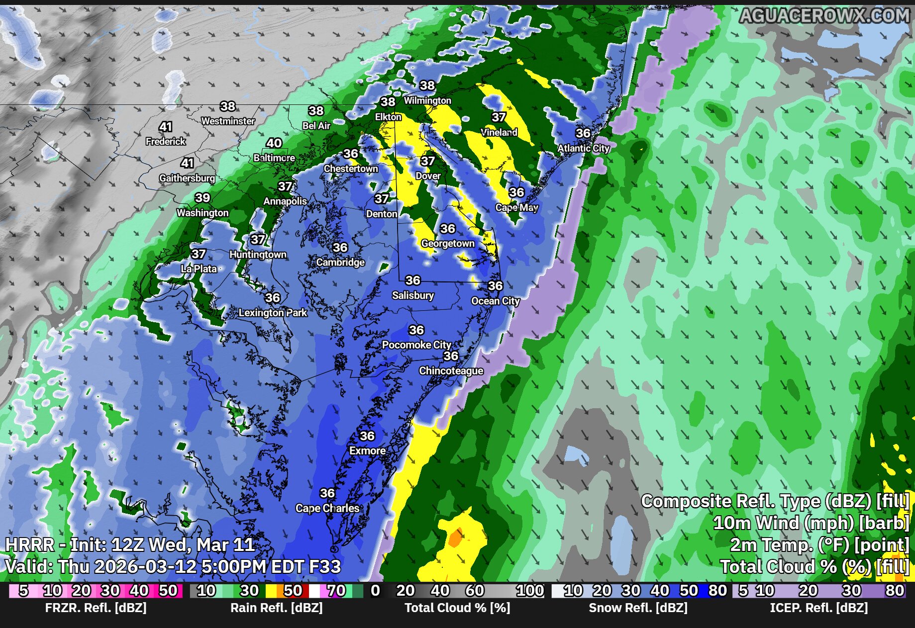
A strong cold front moving through the region early Thursday morning will bring a dramatic change in the weather across the Delmarva Peninsula, replacing the recent warmth with gusty winds and much colder temperatures through the day.
Behind the cold front, a surge of colder air will rapidly move in from the west. Temperatures will start the day relatively mild early Thursday morning, but readings will steadily fall throughout the day as the colder air takes hold. Many areas across Delmarva are expected to drop from the 50s during the morning into the 40s by the afternoon.
As the front moves offshore, a small disturbance riding along the boundary may produce a few additional showers across the region during the morning and early afternoon. Some forecast models suggest the possibility of rain briefly mixing with wet snow before ending, particularly as colder air deepens in the atmosphere. However, this scenario may be overdone as much drier air quickly moves in behind the front.
With the incoming dry air likely to shut down precipitation fairly quickly, any lingering showers should taper off from west to east through the day. Even if a brief rain and snow mix were to occur, temperatures will remain above freezing, meaning no snow accumulation is expected.
The most noticeable change on Thursday will likely be the wind. Strong northwest winds will develop behind the cold front as colder air pours into the region. Gusts are expected to reach between 30 and 40 mph through much of the morning and into the early afternoon hours. These winds will combine with falling temperatures to make conditions feel significantly colder compared to the mild weather earlier in the week.
Winds will gradually begin to ease later Thursday afternoon and into the evening, but the colder air will remain firmly in place.
By Thursday night, temperatures across Delmarva are expected to drop sharply, with overnight lows falling into the upper 20s to lower 30s by early Friday morning. The colder conditions will mark a stark contrast from the unseasonably warm weather experienced just a day earlier.
Drivers heading south on Route 1 are facing traffic delays today due to ongoing construction work that has forced the closure of one travel lane.
The Delaware Department of Transportation reports that the left southbound lane of Coastal Highway is blocked between Deep Branch Road and Broadkill Road (Route 16) while crews complete construction activities.
Officials say the lane restriction will remain in effect until 3:00 PM today, after which normal traffic flow is expected to resume.
Motorists are advised to allow extra travel time and use caution when driving through the work zone area.
Drivers traveling south on Route 896 should expect delays near Welsh Tract Road due to ongoing construction activity.
Delaware Department of Transportation officials report that the right turn lane on Summit Bridge Road (Route 896) southbound at the Welsh Tract Road intersection is currently blocked to traffic.
The lane closure is expected to remain in effect until 3 PM today as construction crews complete their work in the area.
Motorists are advised to allow extra travel time and use caution when navigating through the work zone.
A major climate adaptation initiative is coming to Point Lookout State Park in St. Mary’s County, Maryland, with $1.25 million in state funding allocated for comprehensive upgrades designed to combat rising sea levels and frequent flooding.
The Maryland Department of Natural Resources announced the multi-year renovation project will construct a natural living shoreline and permanently close two campground sections that experience constant tidal flooding. The initiative represents the first climate resilience project funded through Maryland’s Great Maryland Outdoors Act, passed in 2022 with $5 million designated for environmental protection efforts.
“The Great Maryland Outdoors Act is building a more resilient future for Maryland State Parks,” said Department of Natural Resources Secretary Josh Kurtz. “The work at Point Lookout and other projects supported by this funding will use nature-based solutions to support our climate adaptation goals while also building community resilience to ensure our parks are accessible to the public for generations to come.”
The comprehensive plan includes establishing a living shoreline system to combat erosion and enhance the park’s natural defenses against rising waters. Two camping areas – Green’s Point Loop and Lanier Loop – will be permanently shuttered due to persistent nuisance flooding, with these sites transformed into picnic facilities for registered campers or restored to their original marsh habitat.
Situated at the southern tip of St. Mary’s County where the Potomac River meets the Chesapeake Bay, Point Lookout faces significant environmental challenges. Scientific projections indicate water levels could climb between 1.5 and 2.5 feet within the next 25 to 50 years, making the park particularly vulnerable to climate impacts.
The Alliance for the Chesapeake Bay has been selected as the nonprofit partner to oversee the project through a competitive application process. The organization will handle technical support, project management, and community outreach efforts.
“The Alliance is eager to collaborate with the Maryland Park Service and Maryland Department of Natural Resources on this important coastal resilience project,” stated Laura Todd, Associate Green Infrastructure Program Director for the Alliance for the Chesapeake Bay. “The upcoming ecological restoration and outreach efforts at Point Lookout will enhance natural resources for the benefit of Chesapeake Bay fish, wildlife, and the many visitors to the park.”
The park’s campground has remained closed since 2021 for critical water and sanitation system repairs, with reopening scheduled for spring 2026. When facilities resume operations, campers will have access to Tulip Loop offering full hookups, mixed-use sites at Malone and Hoffman’s Loops, and the six-site Conoy Loop designed for families and groups.
The living shoreline component will involve strategic placement of sand, installation of marsh vegetation and shrubs, and construction of structures to encourage oyster reef development. Educational signage will be installed to highlight the importance of marsh ecosystems in the face of climate change.
“Support for initiatives such as this is incredibly important to our park system,” noted Jonas Williams, Director of Planning for the Maryland Park Service. “With support from the Great Maryland Outdoors Act, we can ensure Point Lookout State Park is more resilient for future generations.”
Design work is scheduled to commence in early 2026, followed by on-site construction. University of Maryland landscape architecture students have already contributed conceptual designs for the restoration effort.
Additional climate protection work is simultaneously underway at Point Lookout through DNR’s Grants Gateway program, which is funding a living shoreline along the park’s causeway – the sole access route to the facility and historic sites including the Point Lookout Lighthouse and Civil War prisoner-of-war camp location.
Three additional climate adaptation projects funded by the Great Maryland Outdoors Act are expected to launch in 2026, addressing flooding challenges across various landscape types and demonstrating nature-based solutions for infrastructure, habitat, and public safety protection.
“Climate change is reshaping Maryland now — bold adaptation on our state lands is showing how nature-based practices can strengthen Maryland’s resilience,” said Jackie Specht, DNR’s Resilient Systems Officer. “Great Maryland Outdoors Act projects, such as the one in Point Lookout, will protect important areas and serve as models for future action.”
Residents across the Delmarva Peninsula should remain alert Wednesday afternoon and evening as a developing weather system may bring the potential for strong to severe thunderstorms before a powerful cold front sweeps through the region overnight.
A strengthening area of low pressure moving across the eastern Great Lakes this afternoon will track into southern Quebec tonight. As this system intensifies, it will drag a strong cold front eastward across the Mid-Atlantic, arriving in the Delmarva region late tonight into early Thursday morning.
Ahead of the front, a warm and increasingly humid air mass will settle across the region during the day Wednesday. Temperatures will climb well above normal, while dew points rise into the upper 50s and lower 60s. This combination of warmth and moisture will help create a favorable environment for thunderstorms to develop.
We are closely watching a pre-frontal trough expected to form over central Pennsylvania during the afternoon. Thunderstorms that develop along this feature could organize and move eastward into the Delmarva region by mid to late afternoon and into the early evening hours.
Strong winds in the atmosphere will help support organized storm development. Forecast models indicate wind shear values of around 40 to 50 knots, which can help storms organize into line segments capable of producing damaging wind gusts. Some storms may also produce small hail, generally around quarter size, and there is a low but non-zero chance that an isolated tornado could occur.
The overall severe weather threat will depend heavily on how much sunshine develops during the day. If clouds remain widespread or if morning showers limit daytime heating, the atmosphere may not become unstable enough to support stronger storms. However, if breaks of sunshine develop, particularly across southern and western parts of the region, storm intensity could increase.
Current guidance suggests that areas south and west of Philadelphia have the greatest potential for stronger storms. The Storm Prediction Center has placed these areas in a Slight Risk, or Level 2 out of 5, for severe weather. Closer to the coast, including parts of coastal Delaware and New Jersey, the threat is lower due to cooler marine air moving in from the Atlantic Ocean, which tends to stabilize the atmosphere.
After the initial round of thunderstorms moves through Wednesday evening, activity may decrease overnight with only scattered showers expected for a time. The main cold front is forecast to cross the region early Thursday morning. Most of the rain associated with the front appears likely to occur after the boundary passes, which should limit any additional severe weather threat.
Temperatures will remain unusually warm overnight until the cold front moves through. Once the front passes early Thursday morning, temperatures will begin to drop quickly, signaling the arrival of cooler air across the region to start the day.
SALISBURY, Md. – The latest edition of Roadie Joes Rankings was published for the second Wednesday of March, spotlighting several Salisbury University athletic programs.
This week’s rankings include standings for the Sea Gulls’ women’s lacrosse team, baseball squad, men’s lacrosse program, men’s track and field, along with both men’s and women’s swimming teams.
The rankings provide an updated look at how Salisbury’s various athletic programs are performing as the spring sports season continues to unfold.
Worcester County’s Fire Training Center will conduct an emergency services training session next month, according to county officials.
The training event is set for Tuesday, April 21st, 2026, running from 8:00 AM through 4:30 PM at the Fire Training Center facility.
County records show the event was scheduled by staff member M. Owens on March 11th, 2026.
Further details about the specific nature of the emergency services training or participants were not immediately available from Worcester County officials.
Destructive weather systems spawned multiple tornadoes across Illinois and Indiana Tuesday, demolishing houses, toppling trees and electrical lines, and flooding a 911 dispatch center near Chicago with distress calls, authorities reported.
“Please do not come here. Do not try to help right now,” Newton County Sheriff Shannon Cothran warned in a video message recorded in front of what appeared to be a demolished residence in Lake Village, a small community in northwestern Indiana.
Numerous houses in the area were flattened by what appears to have been a tornado, and Indiana State Police Cpl. Eric Rot confirmed that residents sustained injuries. However, he could not specify how many people were hurt or detail their medical status.
Powerful weather systems bringing heavy rainfall and hail across Midwest regions threatened to produce violent tornadoes, destructive winds and oversized hail stretching from the southern Plains through the southern Great Lakes, the National Weather Service reported. Tornado watches extended from Oklahoma through Michigan.
Multiple tornadoes developed throughout northeastern Illinois and northwestern Indiana, though the precise count will remain unknown until authorities complete damage assessments, explained Andrew Lyons, a meteorologist with the weather service Storm Prediction Center.
Lyons characterized the event as a standard early spring severe weather outbreak. The system is forecast to continue eastward through portions of the mid-Atlantic and East Coast on Wednesday, potentially delivering additional severe conditions, he noted.
Illinois Gov. JB Pritzker announced on social media platform X that he had received briefings about the storm and tornado destruction.
“Keeping in our thoughts all Illinoisans impacted by the severe weather — we’ll be here to help them recover,” he stated.
One tornado touched down near the Kankakee fairgrounds, approximately 57 miles south of Chicago, then moved northeast into Aroma Park, causing widespread destruction, the Kankakee County Sheriff’s Office confirmed. Officials reported no injuries in that area.
“I want to remind area residents to check on their neighbors and loved ones but to avoid unnecessary travel, if at all possible,” Kankakee County Sheriff Mike Downey stated.
Social media footage captured the tornado cutting through agricultural fields near an airport as vehicles gathered along nearby roadways.
Over 2 million Americans faced moderate severe weather risks in Illinois and Indiana. An additional 22 million people encountered slightly lower risks across a broader area encompassing Chicago, Fort Worth, Texas, and Oklahoma City, Oklahoma.
Delaware wildlife officials have released the final numbers from the 2025-26 hunting season while simultaneously introducing a digital tool designed to help residents better understand the state’s big game populations.
The Delaware Department of Natural Resources and Environmental Control revealed the statewide deer hunting results alongside the debut of their Division of Fish and Wildlife’s new interactive Game Harvest Dashboard. This online platform allows both hunting enthusiasts and curious Delaware residents to dig deeper into comprehensive data about large game animals throughout the First State.
The timing of both announcements reflects the agency’s commitment to transparency and public engagement regarding wildlife management practices across Delaware.
Motorists traveling through a local construction zone should plan for potential delays this afternoon as work crews continue their project.
Delaware Department of Transportation officials report that Upland Court at South Skyward Drive will experience periodic lane restrictions due to construction activities. The lane closures are expected to continue through 5:30 PM today.
Drivers are advised to use caution when traveling through the work zone and consider alternate routes if possible to avoid potential delays.
Delaware State University’s softball team emerged victorious in a nail-biting contest against Towson University, claiming a 4-3 win that required extra innings to decide.
The Hornets managed to outlast their opponents in a game that stretched to 10 innings before Delaware State could secure the victory. The extended battle showcased both teams’ determination as they fought through regulation play without a decisive outcome.
This triumph adds another win to Delaware State’s season record as the Hornets continue their competitive campaign. The extra-inning victory demonstrates the team’s resilience and ability to perform under pressure in crucial moments.
The close scoreline reflects the competitive nature of the matchup, with both squads trading runs throughout the contest before Delaware State ultimately prevailed in the additional frames.
The University of Delaware Blue Hens softball team experienced a setback in their recent contest against the Maryland Terrapins, falling short in their efforts to secure a victory.
The matchup between the two teams resulted in a loss for the Blue Hens, who were unable to generate enough offensive production to overcome their Maryland opponents.
The defeat adds to the team’s season record as they continue their campaign in collegiate softball competition.
SUGAR LAND, Texas – The University of Delaware women’s golf squad delivered their strongest performance of the tournament during Tuesday’s final round, climbing the standings to secure fifth place at the Riverbend Intercollegiate championship.
The Blue Hens posted the day’s best team score among all 16 competing schools at the Houston Christian University-hosted event. Delaware concluded the three-day tournament with a combined total of 889 strokes, finishing 25 shots above par at Riverbend Country Club.
The challenging course, measuring 6,153 yards with a par of 72, served as the backdrop for the competitive field throughout the tournament weekend.
SALISBURY, Md. – The second-ranked Salisbury University Sea Gulls baseball team staged a thrilling comeback attempt but fell just one run short, dropping an 8-7 decision to the Messiah Falcons on Tuesday at Donnie Williams Sea Gull Baseball Stadium.
Facing a five-run deficit heading into the bottom of the ninth inning, the Sea Gulls mounted an impressive rally by plating four runs in their final at-bat. However, the team was unable to score the crucial tying run that would have sent the game into extra innings.
The loss came despite the dramatic late-inning surge that brought the home crowd to its feet as Salisbury nearly pulled off what would have been a remarkable comeback victory against the visiting Falcons.
A standout athlete from Salisbury University’s men’s lacrosse squad has earned national recognition for his exceptional play on the field.
Blake Malamphy was selected as the National Division Three Player of the Week by USA Lacrosse Magazine, the publication announced Tuesday morning. The honor follows Malamphy’s outstanding showing during Saturday’s game for the Sea Gulls, who currently hold the fifth position in national rankings.
The weekly award highlights top performances across Division III men’s lacrosse programs nationwide. Malamphy’s selection puts a spotlight on the strong lacrosse tradition at Salisbury University, located in Sparks, Maryland.
DOVER, DE (March 10, 2026) – Delaware insurance officials are stepping forward to clear up confusion among homeowners who worry that ongoing property reassessments across the state will lead to higher insurance bills.
The state’s Department of Insurance, along with its Consumer Services & Investigation division, is launching an educational effort to inform residents that property value reassessments have no direct connection to homeowners insurance premium calculations.
According to state officials, numerous Delaware residents have reached out with concerns that the statewide reassessment process currently underway will automatically trigger increases in their annual insurance costs.
The department’s advisory aims to explain the actual factors that insurance companies use when determining premium rates for homeowners policies.
HUNTSVILLE, Ala. – The University of Delaware women’s basketball squad delivered a commanding performance Tuesday night, overwhelming ninth-ranked Kennesaw State 66-47 during their inaugural Conference USA Basketball Championship appearance at Propst Arena.
The historic victory marks the Fightin’ Blue Hens’ first-ever participation in the CUSA postseason tournament, and they made it count with a dominant showing against a highly-ranked opponent.
Leading the charge was Cherisier, who matched her personal best with 24 points in the crucial tournament opener. Her stellar performance helped propel Delaware to a convincing 19-point margin of victory.
The Blue Hens now advance to Wednesday’s quarterfinal matchup, where they’ll face the tournament’s top seed, Louisiana Tech. That game is scheduled for 12:30 p.m. as Delaware continues their remarkable postseason run.
The impressive upset victory showcases the program’s growth and establishes Delaware as a legitimate contender in their debut CUSA tournament appearance.
NEWARK, Del. – The University of Delaware’s Department of Athletics, Community, and Campus Recreation has revealed plans to bring back their popular high school team days program when the spring 2026 season begins.
The program allows local high school athletic teams to attend University of Delaware sporting events without paying admission fees. Teams interested in participating must provide their complete roster information ahead of time to qualify for the free entry to designated Blue Hens games and matches.
The initiative represents the university’s continued effort to strengthen connections between the Blue Hens athletics program and high school sports teams throughout the region.
The University of Delaware women’s lacrosse squad is set to take their talents on the road for an upcoming contest against the Drexel Dragons in Philadelphia.
The Blue Hens will travel to face their opponents in what marks another important game in their season schedule. The team continues to build momentum as they prepare for this matchup against Drexel.
Delaware’s women’s lacrosse program remains focused on their competitive season as they take on conference and regional rivals throughout the spring campaign.
Tourism officials in Ocean City, Maryland are rolling out an innovative social media campaign designed to showcase what makes their coastal destination special.
The new video series, titled “Only in Ocean City,” will make its debut on Friday, April 3rd, according to an announcement made March 10th by Ocean City Tourism officials.
The campaign aims to capture the distinctive experiences, seaside appeal, and unique attractions that set the popular Maryland beach resort apart from other coastal destinations along the East Coast.
Officials say the series will focus on highlighting unexpected adventures and the special character that draws visitors to the oceanfront community year after year.
The University of Delaware athletics department has unveiled its schedule of sporting events and activities for the current week, according to information released Tuesday, March 10.
The Blue Hens’ weekly athletics calendar provides fans and supporters with upcoming games, matches, and other athletic department activities across various sports programs.
The athletics schedule serves as a guide for University of Delaware sports enthusiasts looking to attend or follow their favorite teams throughout the week.
A strong cold front is expected to move through the region late Wednesday night into early Thursday morning, bringing a period of showers and possibly a few strong thunderstorms.
Ahead of the front, warmer and more humid air will move into the area Wednesday. This could help showers and a few thunderstorms develop as the cold front approaches overnight. While a few storms could become strong, the overall threat for severe weather across Delmarva appears to be relatively lower.
One reason for the lower risk locally is the influence of the Atlantic Ocean. Water temperatures are still very cold this time of year, which creates a stable marine layer near the coast. This cooler, more stable air can weaken storms as they move east toward the Delmarva Peninsula.
The greater risk for stronger storms is expected to remain farther inland, mainly west of our area, where conditions will be more favorable for storms to stay organized with the threat of strong winds, some small hail and a limited tornado risk across Western Maryland.
Even so, residents across Delmarva should expect periods of showers and rounds of thunder late Wednesday night into early Thursday morning.
After the cold front moves through Thursday morning, temperatures will begin to fall during the day as much colder air moves in. In fact, the warmest temperatures Thursday may occur just after midnight before dropping into the 40s by late afternoon with gusty northwest winds.
Unseasonably warm air is moving into the region today as strong southerly winds bring a much milder and more humid airmass across Delmarva. Afternoon temperatures are expected to climb into the mid to upper 70s, putting some locations within reach of record high temperatures for this time of year. And a few isolated areas have a shot of near 80 degrees!
Winds will increase from the south to southwest with gusts up to 20 to 25 mph, helping push the warm air northward. Humidity will also increase, with dew points rising into the upper 50s and low 60s, making it feel more like late spring than early March.
Areas along the immediate coast will likely stay a bit cooler due to the southerly wind coming off the still-cold Atlantic Ocean, but inland communities could see temperatures approach daily records.
Cloud cover will gradually increase through the day Wednesday, and a few showers may begin developing later in the afternoon, especially across western parts of the region ahead of an approaching cold front.
Drivers across the Delmarva Peninsula should prepare for hazardous conditions overnight as the National Weather Service has issued a Dense Fog Advisory effective from midnight tonight through 10:00 AM Tuesday morning.
Visibility could drop to just one quarter mile or less in dense fog, creating dangerous driving conditions throughout the region. The advisory affects Kent and Inland Sussex Counties in Delaware, along with Talbot County in Maryland. Several New Jersey counties are also under the advisory, including Western Monmouth, Atlantic, Cumberland, Ocean, and Southeastern Burlington.
The thick fog is expected to develop after midnight and persist through the Tuesday morning commute, potentially causing significant delays for travelers.
Motorists are strongly advised to slow down, use headlights, and maintain extra distance between vehicles when driving in these conditions. If visibility becomes extremely limited, drivers should consider pulling over safely until conditions improve.
The Dense Fog Advisory was issued by the National Weather Service Mount Holly office at 7:33 PM Monday evening and will remain in effect until 10:00 AM Tuesday. Commuters should allow extra travel time and stay updated on changing conditions throughout the night and early morning hours.
After several days of unseasonably warm weather across the Delmarva Peninsula, a strong cold front is expected to sweep through the region Wednesday night into Thursday, bringing widespread showers and the possibility of a few thunderstorms.
The weather pattern will begin to turn more active by midweek as a potent upper-level trough moves east from the central United States. As this system approaches, large-scale lift in the atmosphere will begin increasing across the Mid-Atlantic during the day Wednesday.
The first showers may begin to develop Wednesday afternoon, mainly across areas north and west of the Interstate 95 corridor. Much of Delmarva should remain mostly dry during the daytime hours, though clouds will likely increase through the afternoon.
Rain chances will increase significantly Wednesday night as the main system approaches. A surface low associated with the upper trough is forecast to track north of the region through the Great Lakes and into southern Canada. Trailing behind that system will be a strong cold front, which is expected to move through the Mid-Atlantic early Thursday morning.
As the front approaches Wednesday night, a line of showers is expected to move across the region, bringing a period of widespread rainfall. While the overnight timing should limit the potential for severe weather, forecasters say there is still a slight chance for isolated thunderstorms due to some elevated instability in the atmosphere.
In addition to the rain, winds are expected to become increasingly gusty as the system moves through. Even outside of heavier showers, a strengthening wind field in the atmosphere could lead to occasional gusts across the region late Wednesday night and into Thursday.
Behind the cold front, rain will gradually taper off during the day Thursday as colder air begins filtering into the Mid-Atlantic. A few lingering rain or even brief snow showers cannot be ruled out later Thursday as temperatures fall.
This system will mark the end of the recent stretch of spring-like warmth, with cooler conditions expected to return to the Delmarva region heading into the end of the week.
A stretch of unusually warm weather is expected across the Delmarva Peninsula through Wednesday, with temperatures running well above average for early March and potentially approaching record levels in some locations.
The warm pattern is being driven by a stable upper-level weather pattern combined with high pressure positioned over the western Atlantic Ocean. This setup acts almost like a heat pump, allowing very mild air to surge northward into the Mid-Atlantic region.
As a result, daytime temperatures across much of Delmarva are forecast to climb into the low to mid 70s through midweek. That is roughly 20 to 25 degrees warmer than normal for this time of year. Overnight temperatures will also remain mild, with lows generally falling into the 40s and 50s.
The warm temperatures will be most noticeable inland across Delaware and Maryland’s Eastern Shore. However, communities along the Atlantic coast will stay noticeably cooler due to the influence of the chilly ocean waters. High temperatures near the beaches are expected to remain mostly in the 50s as a daily sea breeze develops during the afternoon hours.
While record temperatures appear unlikely on Tuesday, some locations could challenge or even break daily record highs by Wednesday if the warm air remains firmly in place.
Another feature of this mild pattern will be the development of fog, especially during the nighttime and early morning hours. Increasing moisture in the atmosphere combined with cool ocean temperatures will create favorable conditions for fog formation. Coastal areas will be most prone to fog, but it may spread farther inland overnight before dissipating each morning.
Despite the fog potential, the overall pattern remains quiet and stable through midweek, bringing a prolonged period of spring-like warmth to the Delmarva region.
Drivers traveling eastbound on Harmons Hill Road should expect delays this afternoon as construction crews have shut down one lane at the intersection with Indian Mission Road.
According to the Delaware Department of Transportation, the eastbound lane closure is scheduled to remain in place until 4:30 PM today while construction work continues in the area.
Motorists are advised to plan alternate routes or allow extra travel time when passing through this section of Harmons Hill Road.
The Ocean Pines Water & Wastewater Advisory Board has announced its upcoming meeting scheduled for Tuesday, January 13, 2026, beginning at 9:00 AM.
Worcester County officials have made the meeting agenda available to the public through their official website. The agenda document, labeled “Agenda 01-13-26.pdf,” can be accessed online for residents who wish to review the topics that will be discussed during the session.
The meeting notice was posted on March 9, 2026, giving community members advance notice of the upcoming board session. Residents interested in water and wastewater matters affecting the Ocean Pines community can find additional meeting information and calendar details on the Worcester County website.
Worcester County officials have announced an upcoming meeting of the Solid Waste Advisory Board scheduled for Wednesday, January 14, 2026, beginning at 9:00 AM.
The meeting agenda was posted on Monday, March 9, 2026, and is now available for public review through the county’s official website. Residents interested in waste management issues can access the complete agenda document online.
The advisory board regularly convenes to discuss waste management policies and procedures affecting Worcester County residents. Those seeking more information about the meeting can find additional details on the county’s events calendar.
Thick fog is creating hazardous travel conditions across much of the Delmarva Peninsula this morning, with visibility dropping to just a quarter mile or less in many areas.
The National Weather Service has issued a Dense Fog Advisory affecting Kent and Sussex counties in Delaware, including Delaware’s beaches, along with portions of Caroline County on Maryland’s Eastern Shore. The advisory also extends into southern New Jersey, covering Salem, Gloucester, Camden, Ocean, Cumberland, Atlantic, and Cape May counties.
The fog advisory remains in effect until 10 AM this morning, making the Monday morning commute particularly treacherous for drivers throughout the region.
“Low visibility could make driving conditions hazardous,” warns the National Weather Service. Officials are urging motorists to take extra precautions if they must travel during these conditions.
If you need to drive this morning, weather officials recommend slowing down significantly, using your headlights even during daylight hours, and maintaining plenty of distance between your vehicle and others on the road.
Conditions are expected to improve as temperatures rise and the fog begins to lift throughout the morning hours. Drivers should continue monitoring visibility conditions and adjust their travel plans accordingly until the advisory expires at 10 AM.
Motorists will need to find alternate routes along Turkey Point Road as a significant stretch remains blocked off for construction activities.
The Delaware Department of Transportation reports that Turkey Point Road between State Route 15 (Main Street) and Tuxedo Lane will stay inaccessible to through traffic until March 16, 2026, at 7:00 PM.
The extended closure affects daily commuters and local residents who regularly use this roadway for transportation. Drivers are advised to plan alternative routes and allow extra travel time while the construction project continues over the next two years.
Delaware Department of Transportation officials are advising drivers of ongoing traffic disruptions along a section of Lesley Lane today.
The roadway is experiencing intermittent lane restrictions between East Roosevelt Avenue and Morrison Road, with the closures expected to remain in effect until 5:00 PM this afternoon.
Motorists using this route should plan for potential delays and consider alternate paths if possible. DelDOT has not specified the reason for the lane restrictions in their traffic advisory.
Drivers are encouraged to exercise caution when traveling through the affected area and to allow extra time for their commute.
A Dense Fog Advisory remains in effect across much of the Delmarva Peninsula this morning, with visibility dropping to just a quarter mile or less in some areas.
The National Weather Service issued the advisory at 1:10 AM and it will remain in effect until 10:00 AM today. The thick fog is impacting driving conditions across Kent and Sussex counties in Delaware, including the Delaware beaches, as well as parts of the Eastern Shore including Caroline County in Maryland.
The advisory also extends into southern New Jersey, affecting Salem, Gloucester, Camden, and Burlington counties, along with Ocean, Cumberland, Atlantic, and Cape May counties, including coastal areas.
Motorists are urged to exercise extreme caution during the morning commute. If you must drive, the National Weather Service recommends slowing down, using your headlights, and leaving plenty of distance between you and the vehicle ahead.
Visibility could remain severely limited through the early morning hours, making driving conditions particularly hazardous on highways and rural roads throughout the region.
The fog is expected to gradually lift as temperatures warm later this morning. Commuters should allow extra travel time and consider delaying non-essential trips until conditions improve.
Motorists should expect delays on a busy Delaware roadway today as construction crews continue their work on Park Avenue.
The westbound lanes of Park Avenue, also known as US Route 9, have a lane closure in effect between Cedar Lane and Nanticoke Avenue. According to the Delaware Department of Transportation, the construction-related restriction will remain active until 5 PM today.
Drivers are advised to plan alternate routes or allow extra travel time when navigating through the affected area during the closure period.
Motorists traveling through a Delaware neighborhood should prepare for potential delays as construction crews continue work that requires periodic lane restrictions.
According to the Delaware Department of Transportation, drivers can expect intermittent lane closures along Upland Court where it intersects with Skyward Road. The construction-related traffic restrictions are set to continue through 5 PM today.
Officials advise drivers to allow extra travel time when using this route and to exercise caution when approaching the work zone area.
Motorists traveling on Atlanta Road should expect temporary lane changes today as construction crews continue their work in the area.
According to DelDOT, drivers will encounter lane switches on Atlanta Road in the section between Oak Street and West Stein Highway. The altered traffic pattern is expected to remain in place until 3:30 PM this afternoon.
Drivers are advised to use caution when traveling through the construction zone and to allow extra time for their commute. Traffic may experience delays as vehicles navigate the temporary lane configuration.
A motor vehicle accident has forced the closure of Gravel Hill Road, blocking traffic in both directions between Sand Hill Road and Neptune Road.
Delaware Department of Transportation officials report the roadway is currently impassable due to the collision. Drivers are being advised to find alternate routes while emergency crews work at the scene.
No additional details about the crash have been released at this time. The duration of the road closure remains unknown as responders continue their work.
Weather officials have issued a dense fog advisory for the Delmarva region, warning residents of potentially hazardous driving conditions during the early morning hours.
The National Weather Service office in Mount Holly, New Jersey issued the advisory at 1:10 AM on March 9th, with the warning remaining active until 10:00 AM the same day.
Motorists are advised to exercise extreme caution during the advisory period, as visibility may be significantly reduced. Drivers should reduce speeds, use low-beam headlights, and maintain greater following distances when traveling in foggy conditions.
The weather service typically issues these advisories when visibility is expected to drop to one-quarter mile or less due to fog formation.
A Dense Fog Advisory remains in effect across much of the Delmarva Peninsula this morning, with visibility dropping to just one quarter mile or less in some areas.
The National Weather Service issued the advisory at 1:10 AM and expects the dangerous conditions to persist until 10:00 AM today. The thick fog is impacting Kent and Sussex counties in Delaware, including Delaware’s beaches, as well as portions of the Eastern Shore including Caroline County in Maryland.
The advisory also extends into southern New Jersey, affecting Salem, Gloucester, Camden, Ocean, Cumberland, Atlantic, and Cape May counties, including coastal areas.
Drivers across the region are experiencing severely reduced visibility, making morning commutes particularly treacherous. Local law enforcement agencies are urging extreme caution on all roadways.
If you must travel this morning, the National Weather Service recommends slowing down significantly, using your headlights even during daylight hours, and maintaining extra distance between vehicles. Avoid using high beams, which can reflect off the fog and actually reduce visibility further.
Conditions should gradually improve throughout the morning as temperatures rise and winds increase. Commuters should check local traffic reports and consider delaying non-essential travel until the fog lifts completely around mid-morning.
A Dense Fog Advisory is currently in effect across much of the Delmarva Peninsula, with visibility dropping to just a quarter mile or less in some areas this morning.
The National Weather Service issued the advisory at 1:10 AM and it remains in effect until 10:00 AM today. The dense fog is impacting portions of central and southern Delaware, including Kent County, inland Sussex County, and Delaware’s beaches, along with parts of the Eastern Shore of Maryland and southern New Jersey.
Motorists are experiencing hazardous driving conditions due to the severely reduced visibility. If you must travel this morning, the National Weather Service strongly recommends slowing down, using your headlights, and leaving plenty of distance between your vehicle and the car ahead of you.
The fog is expected to gradually lift as we move through the morning hours, with conditions improving by mid-morning. However, drivers should remain cautious during the morning commute as pockets of dense fog may linger in some areas.
We’ll continue monitoring conditions throughout the morning and provide updates as the fog begins to clear. For the latest traffic conditions and road closures, check our website and social media channels.
Delaware transportation officials have shut down all westbound lanes of US Route 40 at DE Route 72 following a vehicle collision in the area.
The crash has resulted in a complete closure of the westbound direction, forcing drivers to seek alternate routes. Motorists traveling through the region should expect significant delays and plan accordingly.
Authorities have not yet released details about the severity of the accident or when the roadway might reopen to traffic. Drivers are advised to avoid the area if possible and use alternative routes until the situation is resolved.
Drivers traveling north on Interstate 95 in New Castle County are experiencing lane restrictions this morning as DelDOT continues work along a busy stretch of highway.
The left lane of northbound I-95 remains blocked between the Route 896 interchange and the Delaware Welcome Center. Officials say the closure will stay in place until 6 a.m.
Motorists should expect potential delays and are advised to move to the right lanes when approaching the work zone. The restriction affects traffic heading toward the Pennsylvania border in the northern part of the state.
Motorists traveling on Delaware Route 896 will encounter periodic lane restrictions in both the northbound and southbound directions through the early morning hours, according to DelDOT officials.
The intermittent rolling closures are scheduled to remain in effect until 5 a.m., potentially impacting commuter traffic and other travelers using the corridor.
Drivers are advised to plan for possible delays and consider alternate routes if traveling through the area during the closure period.
The Goldey-Beacom Lightning baseball squad finished their weekend series against Queens University of New York by earning a split in Saturday’s twin bill played in Flemington, New Jersey.
The Lightning commanded the day’s opening matchup, cruising to a convincing 14-7 triumph over their opponents from Queens. However, the team couldn’t maintain that momentum in the nightcap, suffering a 7-3 setback to conclude the four-game series.
The doubleheader results capped off what had been an extended series between the two programs, with both teams now heading into their next scheduled contests.
SALISBURY, Md. – The Salisbury University Sea Gulls men’s tennis squad delivered an impressive 5-1 victory against the Gettysburg Bullets during Sunday evening’s Senior Day celebration at the SU Indoor Tennis Center.
Before the match began, the team took time to recognize their two graduating players, Aron Bursztyn and Tim Holt, acknowledging their contributions to the program throughout their collegiate careers.
Following the pre-match ceremony, the Sea Gulls took control of the competition, securing a decisive win that showcased the team’s strength and depth across multiple positions.
Commuters using Route 141 southbound are facing traffic disruptions this morning as DelDOT reports a lane closure affecting the busy corridor.
The right travel lane is currently blocked between the James Street exit and Exit 4B, with the restriction expected to remain in place until 4:00 AM.
Drivers are advised to allow extra travel time and merge safely into the left lane when approaching the affected area. DelDOT recommends using alternate routes if possible to avoid potential delays during the morning rush hour.
Four athletes from Salisbury University’s track and field program have secured spots to compete at the national level after earning qualification for the 2026 NCAA Division III Indoor Championships.
The Sea Gulls will be represented by Kai Smith in the 60-meter and 200-meter sprints, Gavin Shaffer in the 60-meter hurdles, Marlyse Haack in the triple jump, and Mia Hill in the long jump events.
These four competitors will join the nation’s top collegiate athletes when the championship takes place March 13-14 at Birmingham Crossplex in Birmingham, Alabama. The qualification marks a significant achievement for the university’s track and field program, earning the opportunity to compete on one of college athletics’ premier stages.
Good evening, Delmarva! We’re wrapping up this Sunday with mild conditions across the peninsula. Temperatures are settling around 42 degrees tonight with just a slight chance of light rain before 7pm – only a 20% chance, so most of us will stay dry. Any rainfall amounts will be minimal, less than a tenth of an inch.
Skies will turn mostly cloudy overnight with very light west winds up to 5 mph, making for a comfortable evening if you’re heading out.
Looking ahead to Monday, we’re in for a beautiful turnaround! Expect some patchy fog early in the morning, but that will quickly give way to sunny skies and a pleasant high near 66 degrees. It’s shaping up to be a gorgeous start to the work week.
Monday night stays nice with partly cloudy skies and temperatures dipping to around 45. Tuesday continues the pleasant trend with mostly sunny conditions and highs reaching 70 degrees – definitely feeling more like spring!
Enjoy the mild weather, and I’ll see you tomorrow with your updated forecast. This is your TV Delmarva weather team!
BALTIMORE, Md. – Salisbury University’s highly-ranked baseball squad struggled to find their rhythm during Sunday’s matchup against Johns Hopkins University, ultimately losing 7-2 to the Blue Jays at Babb Field.
The Sea Gulls, who entered the game ranked second nationally, were unable to match the offensive output of their fifth-ranked opponents during the afternoon contest. The defeat marks a setback for the Salisbury team as they continue their season against top-tier competition.
The game took place on Johns Hopkins’ home field, where the Blue Jays capitalized on their home advantage to secure the decisive victory over the visiting Sea Gulls.
Delaware drivers heading south on Interstate 95 are facing traffic delays this morning after a vehicle breakdown forced the closure of the left lane at the Newark Toll Plaza.
The disabled vehicle is blocking traffic flow in the leftmost lane of the southbound lanes, creating a bottleneck for commuters passing through the toll area.
DelDOT officials are working to clear the broken-down vehicle and restore normal traffic patterns. Motorists are advised to expect delays and consider alternate routes if possible while crews work to resolve the situation.
The incident serves as a reminder for drivers to move disabled vehicles to the shoulder when safe to do so, or call for emergency assistance if the vehicle cannot be moved out of active traffic lanes.
The Goldey-Beacom Lightning’s historic pursuit of a Central Atlantic Collegiate Conference championship ended in heartbreak Saturday night, falling to Felician University by a final score of 91-81 in the title game held in Caldwell, New Jersey.
The Lightning entered the championship contest seeking to capture the program’s first-ever CACC title, but were unable to overcome their opponents in the decisive matchup. Despite the loss, the team’s run to the conference finals represents a significant achievement for the Wilmington-based college basketball program.
The 10-point margin of defeat shows the Lightning remained competitive throughout the contest, though they ultimately could not complete their championship aspirations against Felician in the winner-take-all finale.
SALISBURY, Md. – Four graduating players received recognition before Salisbury University’s women’s tennis squad delivered a commanding shutout performance against Gettysburg on Sunday at the SU Indoor Tennis Center.
The Sea Gulls celebrated seniors Elizabeth Coligan, Olivia Hall, Leah Osmon, and Evelyn Whiteside prior to their flawless 7-0 victory over the visiting Bullets.
The perfect afternoon saw Salisbury win every singles and doubles match without dropping a set to Gettysburg, capping off a memorable Senior Day celebration for the four-player graduating class.