Delaware drivers are being urged to exercise extreme caution this morning as thick fog has settled across the First State, creating hazardous driving conditions with reduced visibility.
The Delaware Department of Transportation reports that dense fog with varying levels of intensity has been spotted throughout all three counties, prompting officials to issue a travel advisory for motorists.
Visibility conditions are fluctuating across different areas of the state, making it difficult for drivers to see clearly on roadways. Transportation officials recommend reducing speed, increasing following distance, and using low-beam headlights when navigating through the foggy conditions.
Drivers should allow extra time for their commute and consider delaying non-essential travel until visibility improves. The fog is expected to impact morning travel times as commuters head to work and school.
Delaware residents will soon have access to DMV services in Wilmington again, as the state facility prepares to resume operations next year.
The Wilmington Department of Motor Vehicles location is set to reopen its doors on March 10, 2026, according to state transportation officials. However, walk-in service will not be available when the office returns to operation.
All customers seeking DMV services at the Wilmington location will need to schedule appointments in advance once the facility begins serving the public again. This appointment-only system will be in effect from the reopening date forward.
The announcement comes as Delaware continues to manage service delivery at various DMV locations throughout the state. Residents who need immediate DMV services can visit other operational locations or utilize online services where available.
Motorists should plan for delays on a section of Hardin Lane today as construction crews continue their work in the area.
Delaware Department of Transportation reports that periodic lane restrictions are affecting traffic on Hardin Lane between Phyllis Drive and Darwin Drive. The construction-related closures are expected to continue throughout the day until 6 PM.
Drivers are advised to allow extra travel time when using this route and consider alternate paths if possible to avoid potential delays.
Drivers using Estates Drive should plan for potential delays as road crews conduct intermittent flagging operations in the area.
The traffic control work is taking place along the stretch of Estates Drive that runs between Appleby Road and Conlin Court. Officials say the flagging operations will remain in effect until 6 PM today.
Motorists are advised to allow extra travel time when using this route and to exercise caution when approaching the work zone area.
Motorists traveling through a section of Bayard Avenue are facing traffic delays today due to ongoing construction work.
Delaware Department of Transportation officials report that one lane is currently closed on Bayard Avenue in the area between Chesapeake Street and Carolina Street. The lane restriction is expected to remain in place until 4 PM this afternoon.
Drivers are advised to allow extra travel time when passing through the affected area and to use caution around construction workers and equipment.
Motorists traveling on Route 72 northbound should expect delays due to ongoing construction work that has reduced traffic to fewer lanes.
The Delaware Department of Transportation reports that Chapel Street/Sunset Lake Road northbound is experiencing a lane closure in the stretch between South Old Baltimore Pike and the Interstate 95 overpass.
Officials indicate the construction-related lane restriction will continue through 3:00 PM today before normal traffic patterns resume.
Drivers are advised to allow extra travel time or consider alternate routes to avoid potential congestion in the affected area.
Motorists traveling on Chicago Street should expect delays due to ongoing construction work that has reduced the roadway to one lane.
The lane closure affects the stretch of Chicago Street from King Charles Street to where the road terminates. Delaware Department of Transportation officials report the construction activity will keep one lane blocked until 4 PM today.
Drivers are advised to seek alternate routes or allow extra travel time when navigating through the affected area.
Drivers using Route 12 southbound in Frederica are dealing with traffic delays today as construction crews have shut down one lane of travel.
The lane restriction affects the stretch of Frederica Road between Front Street and Market Street, according to DelDOT traffic officials.
The construction work and resulting lane closure is scheduled to wrap up by 4 PM today. Motorists are advised to allow extra travel time or consider alternate routes to avoid potential backups in the area.
Motorists traveling on Chicago Street should expect delays today due to ongoing construction work that has reduced traffic to one lane.
The lane closure affects the stretch of Chicago Street from King Charles Street extending to where the roadway terminates. According to DelDOT officials, the single-lane restriction will remain active until 4 PM this afternoon.
Drivers are advised to seek alternate routes or allow extra travel time when navigating through the construction zone.
Motorists traveling through the area of Upland Court at S Skyward Drive should plan for potential delays as construction crews continue work that requires periodic lane restrictions.
The Delaware Department of Transportation reports that drivers may encounter intermittent lane closures at this location until 5:30 PM today.
Officials advise allowing extra travel time and using alternate routes when possible to avoid congestion in the construction zone.
Virtually the entire United States is experiencing or preparing for severe weather conditions as multiple extreme systems converge across the nation.
Hawaii has begun experiencing days of heavy rainfall. The Southwest is preparing for consecutive days of record-breaking temperatures exceeding 100 degrees (38 Celsius). Two storm systems are expected to deliver feet of snow across northern Great Lakes regions. Meanwhile, the polar vortex is set to bring bone-chilling Arctic temperatures to the Midwest and Eastern states.
This extreme weather forecast follows dramatic temperature swings that have already affected much of the East Coast. Washington, D.C. residents enjoyed record-breaking 86-degree Fahrenheit (about 30 Celsius) weather on Wednesday, walking around in shorts, only to see snowfall the following day.
“All of the country, even if you’re not necessarily seeing extremes, are going to see generally changing from cold to warm, or warm to cold to warm,” said meteorologist Marc Chenard of the weather service’s Weather Prediction Center in Maryland.
Former National Oceanic and Atmospheric Administration chief scientist Ryan Maue said he expects extreme weather in all 50 states.
A heat dome will establish itself early next week over the Southwest, creating triple-digit temperatures unprecedented for this time of year, according to both Maue and Chenard.
Weather predictions show Phoenix reaching 98 degrees (almost 37 Celsius) on Tuesday, followed by 103, 105 and two consecutive days of 107 degrees (almost 42 C). Phoenix’s 137-year weather history shows the city has never reached 100 degrees before March 26, typically hitting its first century mark in early May, according to the weather service, which cautioned residents: “Since we are not acclimated to this level of heat this early in the year, it will be more impactful than usual.”
Los Angeles has already begun experiencing this pattern with unusual March temperatures reaching 90 degrees, sending residents in shorts and tank tops searching for any available shade, including narrow strips cast by light poles.
Shane Dixon, 40, typically completes 5-mile runs near his Culver City home without difficulty, but Thursday’s heat forced him to cut his workout short, his face covered in sweat and his T-shirt tucked into his shorts.
“The back of my neck was melting,” he said. But he preferred it to the cold and snow that will hit elsewhere.
“I could go literally soak myself and walk out in the sun and I’ll make it home fine. If it was freezing cold I could not do this,” he said.
Simultaneously with Phoenix’s heat wave, the polar vortex — a system that typically contains frigid air near the North Pole — is predicted to push its chill deep into the Midwest and East, potentially reaching parts of the Southeast, Maue explained.
Minneapolis temperatures will drop to around zero, while Chicago will experience single digits on Tuesday. The following day will bring “temperatures in the teens and 20s in the northeast and 20s in the Mid-Atlantic,” Maue said. Atlanta could see temperatures drop into the 20s.
Two consecutive storm systems — the first arriving Friday, followed by another Sunday through Monday — will move across the nation’s northern regions and Great Lakes, potentially depositing 3 to 4 feet of snow in some areas, Maue explained.
The second, larger storm system will experience such rapid barometric pressure drops — indicating intensification and strengthening winds — that it will qualify as a bomb cyclone, an unusual phenomenon over land. While bomb cyclones typically draw energy from warm ocean waters, this system will derive power from the polar vortex.
Maue said Hawaii is getting an atmospheric river that will have such persistent heavy rain that flooding will be a major issue. Oahu is under a flash flood warning.
Alaska, normally frigid during this season, will experience temperatures approximately 30 degrees below normal, he noted.
“It is the time of year where we can see stuff like this,” Chenard said. “But this does seem even anomalous from what you would typically see. I mean, some of these areas will be setting records. Record-high temperatures for March and maybe multiple times.”
Over the past week, tornadoes have claimed at least eight lives in Oklahoma, Michigan and Indiana. While severe storm forecasts don’t appear as extensive or widespread for the coming week, dangerous thunderstorms could develop “anywhere from the Mississippi Valley toward the East Coast” on Sunday or Monday, Chenard said.
An erratic jet stream underlies these conditions, both Maue and Chenard explained.
The jet stream functions as an air river that transports weather from west to east along a roller-coaster-like trajectory. Typically, these dips resemble gentle kiddie roller coaster movements. Currently, however, the jet stream is creating nearly vertical, dramatic drops followed by steep climbs.
“Which means you get a lot of extremes next to each other,” Maue said. Pacific storm fronts encounter the high-pressure heat dome in the Southwest and get pushed northward to climb that mountainous jet stream peak, “grab access to that cold air reservoir up there” and bring it back down south down the other side of the hill, he said.
Multiple studies have linked unusual jet stream and polar vortex behavior to diminishing Arctic sea ice and human-caused climate change.
However, relief is expected.
“The first day of spring is 20th (of March), and then after that we get recovery,” Maue said.
Drivers should expect delays on Cullen Street today as construction crews have reduced traffic to a single lane along a key section of the roadway.
The lane restriction is in place from King Charles Street extending to where Cullen Street terminates, according to Delaware Department of Transportation officials.
The construction-related closure is scheduled to remain active until 4 PM this afternoon, after which normal traffic patterns are expected to resume.
Motorists are advised to seek alternate routes or allow extra travel time when navigating through the affected area during the closure period.
Worcester County emergency officials have scheduled a comprehensive test of their backup 911 communications system for Tuesday, April 7, 2026.
The testing will be conducted at the Fire Training Center and is expected to run from 8:00 AM until 4:30 PM that day.
The backup 911 center serves as a critical component of the county’s emergency response infrastructure, ensuring continuous emergency communications capability in case the primary system experiences any disruptions.
County officials have not indicated whether the testing will impact regular emergency services or require any special procedures for residents calling 911 during the testing period.
Delaware Department of Transportation officials have implemented a right lane restriction on northbound Interstate 95 for ongoing construction activities.
The lane closure affects the stretch of highway between the toll plaza and the welcome center, with work expected to continue until 6 p.m. today.
Motorists traveling north on I-95 through this section should expect potential delays and are advised to merge safely into the left lane when approaching the construction zone.
Drivers traveling on Darley Road should be aware of construction-related lane restrictions affecting traffic flow today.
According to DelDOT, the shoulder along Darley Road between South Trail and Naamans Road is currently closed to accommodate construction activities. The temporary closure is expected to last until 3 PM this afternoon.
Motorists are advised to use caution when traveling through the work zone and allow extra time for their commute. The construction may cause minor delays as traffic is directed around the closed shoulder area.
With warmer weather on the horizon and homeowners preparing for seasonal yard work, Delaware’s Department of Natural Resources and Environmental Control is issuing an important reminder about proper disposal of grass clippings, leaves, and other organic debris.
State regulations prohibit residents from disposing of yard waste in Delaware’s landfill facilities. However, environmental officials emphasize the positive side of this restriction.
When properly processed through mulching or composting techniques, organic yard materials transform into valuable soil amendments that can significantly improve lawn and garden health, according to DNREC officials.
The agency encourages Delaware homeowners to view their spring cleanup debris not as waste, but as a resource that can enhance their landscaping efforts throughout the growing season.
Motorists traveling through a section of South State Street should expect intermittent traffic delays due to an ongoing moving operation in the area.
The moving activity is taking place along South State Street between West Water Street and Roosevelt Avenue, according to DelDOT traffic reports. The operation is causing periodic disruptions to normal traffic flow as crews work in the roadway.
Officials indicate the moving operation will continue until 5 PM today. Drivers are advised to allow extra travel time when passing through this area or consider alternate routes if possible.
The intermittent nature of the delays means traffic may flow normally at times, then experience brief slowdowns as the moving operation progresses.
Motorists should expect periodic traffic delays along a section of South State Street due to an ongoing moving operation in the area.
According to DelDOT traffic officials, the intermittent moving activity is taking place on South State Street between West Water Street and Roosevelt Avenue. The operation is expected to wrap up by 5 PM today.
Drivers are advised to plan for potential delays or consider alternate routes when traveling through this area until the moving operation concludes this afternoon.
Maryland State Police have launched an investigation into an inmate’s death at Eastern Correctional Institution located in Westover, Somerset County.
Authorities have identified the deceased as 31-year-old Quran Middleton, who was pronounced dead on March 10 by emergency medical personnel. His body has been sent to the Office of the Chief Medical Examiner where an autopsy will be conducted to establish the cause and manner of his death. Middleton had been incarcerated at the Eastern Correctional Institution facility.
Just after midnight, detectives from the Maryland State Police Homicide Unit received notification from the Department of Public Safety and Correctional Services Internal Investigative Unit regarding the inmate fatality. Initial findings suggest that correctional officers discovered Middleton unconscious and lying on the floor of his cell.
Homicide investigators from Maryland State Police arrived at the facility to examine the scene. Forensic technicians from the Maryland State Police Forensic Sciences Division were also dispatched to collect and analyze potential evidence.
Once the investigation concludes, findings will be forwarded to the Somerset County State’s Attorney’s Office for evaluation. The case remains under active investigation.
Goldey-Beacom College has announced the appointment of Heather Faasse as the new head coach for their women’s soccer program.
Faasse will serve as the eighth individual to lead the team throughout the program’s history. She also marks a significant milestone as the first coach to hold this position on a full-time basis.
The college expressed enthusiasm about bringing Faasse aboard to guide the women’s soccer team moving forward.
Maryland officials are inviting seafood lovers to celebrate the state’s prized bivalves during a special promotional event later this month.
The Maryland Department of Agriculture’s Maryland’s Best program announced Monday that Chesapeake Oyster Week will take place from March 20 through March 31. The department is working alongside the Oyster Recovery Partnership to organize the celebration.
During the 12-day event, participating establishments will offer special pricing and promotional deals featuring Maryland-grown oysters. The initiative aims to highlight the quality of local oyster harvests while encouraging consumers to support the regional seafood industry.
The announcement comes as Maryland continues efforts to promote its aquaculture sector and the Chesapeake Bay’s oyster recovery programs.
Drivers traveling through New Castle should prepare for potential delays as state transportation officials have scheduled maintenance work at a busy railroad crossing.
DelDOT has notified the public that routine maintenance activities will begin Monday, March 23rd at 7:00 am at the railroad crossing located on Route 9, also known as Wilmington Avenue. Officials say the project will necessitate periodic lane restrictions in the area of the crossing.
Transportation authorities expect the maintenance project to conclude by 5:00 pm on Friday, April 3rd. Motorists are advised to allow extra travel time and consider alternate routes during the work period.
Motorists traveling through New Castle should prepare for traffic disruptions this week as maintenance crews tackle repairs at a busy railroad crossing.
The Delaware Department of Transportation has scheduled routine maintenance work at the Christina Avenue railroad crossing beginning Monday, March 16th at 7:00 am. Officials say the project will cause periodic lane restrictions at the crossing location throughout the work period.
DelDOT expects crews to wrap up the maintenance project by 5:00 pm on Friday, March 20th. Drivers are advised to plan alternate routes or allow extra travel time when passing through the area during construction hours.
OCEAN CITY, Md. — Firefighters, paramedics, and community supporters gathered recently as the Ocean City Fire Department and Ocean City Volunteer Fire Company held their yearly recognition event.
The ceremony celebrated both career and volunteer personnel who demonstrated exceptional dedication through lifesaving efforts, outstanding job performance, and years of committed service to the community over the past year.
Multiple department members received special recognition for reaching significant service milestones, marking their long-standing commitment to protecting Ocean City residents and visitors.
The annual tradition allows the fire department to publicly acknowledge the brave men and women who risk their lives daily, as well as the community partners who support their mission of public safety.
Drivers using northbound Interstate 495 should plan for potential delays as construction crews continue work that requires closing the right travel lane.
The lane restriction affects the stretch of highway between Exit 2 and Exit 3, with the closure scheduled to remain in effect until 5 a.m.
Motorists are advised to merge left and allow extra travel time when using this section of I-495 during the overnight construction period.
Dover Police are investigating a deadly crash that claimed the life of a pedestrian early Monday morning on North DuPont Highway.
The incident happened around 4:06 a.m. on March 9th in the 200 block of North DuPont Highway’s northbound lanes. According to police, 54-year-old Victoria Bynes was walking across the roadway from east to west when she was struck by a gray Chevrolet Equinox.
The vehicle, driven by a 29-year-old woman, was traveling north in the left lane when the collision occurred. Police say the driver initially continued northbound after the impact but returned to the crash site a short time later.
Authorities noted that Bynes was dressed in dark clothing without reflective materials when the accident happened. Despite immediate efforts by responding officers and emergency medical teams to save her life, Bynes died from her injuries shortly after the crash.
The Dover Police Department’s Collision Reconstruction Unit is leading the investigation, examining all available evidence including witness accounts, physical evidence from the scene, and any surveillance video that may be relevant to the case.
No criminal charges have been filed at this time, though investigators stress the case remains active. Once the investigation is complete, officials will review all findings with the Delaware Department of Justice to determine if any charges are appropriate.
Police are asking anyone who saw the incident or has information about the crash to contact the Dover Police Department at 302-736-7145.
Case Details: Incident Number: 50-26-7693 Date/Time: Monday, March 9th, 2026 at 4:06 a.m. Location: 200 Block of North DuPont Highway (Northbound), Dover, DE Contact: Lieutenant Mark Hoffman, Dover Police Public Information Officer Email: [email protected]
Motorists traveling on Route 41 will encounter periodic lane restrictions overnight as work continues along a stretch of the highway near Newport.
The Delaware Department of Transportation reports that intermittent lane closures are affecting the section of Route 41 situated between Route 2 and Milltown Road. These traffic restrictions will remain in effect until 5:00 AM.
Drivers are advised to use caution when traveling through the work zone and to expect possible delays during the overnight hours. Motorists should consider alternate routes if possible or allow extra travel time when using this corridor.
The Goldey-Beacom Lightning softball squad extended their successful Florida tournament run with a pair of close victories over Minot State on Wednesday in Melbourne.
The Lightning first edged out Minot State in a tight 5-4 contest before following up with another narrow 4-3 triumph against the same opponent later in the day.
The back-to-back wins marked the team’s fifth day of competition during their Florida tournament schedule, as the Lightning continue to build momentum in their spring season campaign.
City crews in Salisbury will conduct water infrastructure repairs on Tuesday, March 10, that will require closing a section of Filmore Street to traffic.
The Waterworks Utilities Division plans to install new water service line infrastructure in the 800 block of Filmore Street as part of the city’s continuing initiative to upgrade and maintain its water delivery network.
Motorists should plan alternate routes as Filmore Street will be blocked to through traffic between Truitt Street and Calloway Street. City officials anticipate completing the work by approximately 3:30 p.m., though unexpected complications could extend the timeline.
Utility locating services and Central Alarm systems have received advance notice of the scheduled infrastructure work.
City officials expressed gratitude for residents’ understanding as crews work to enhance the municipal water system.
A Rehoboth Beach city commissioner delivered sharp criticism against a fellow board member during a recent public meeting, alleging months of inappropriate behavior that has disrupted city operations.
During the March 9 commissioners meeting, Susan Stewart made a formal statement targeting Commissioner Suzanne Goode’s conduct, describing what she characterized as documented misconduct spanning from September 2023 to the present.
Stewart outlined her concerns in a prepared statement to the board:
“I want to address something that is very troubling and I think the time has come that commissioners need to speak out about this. What I’m about to describe is documented, has been formally responded to by the city, and directly affects this body’s ability to serve our residents.”
The allegations Stewart presented included claims that Goode had engaged in racially and sexually inappropriate characterizations of city personnel, made defamatory statements under Delaware law, and harassed staff and commissioners based on religious beliefs. Stewart also accused Goode of making disrespectful comments about disabled relatives of other commissioners.
Additional accusations included unproven claims of corruption against the mayor and other commissioners, failure to fulfill elected duties, backing litigation against the city, and encouraging outside interference in municipal affairs.
Stewart noted that despite multiple formal cease and desist notices from the city, the alleged behavior continued and intensified.
“The City issued formal, multiple cease and desist letters, yet the conduct did not stop. It’s only escalated. That matters, because it tells us this is not inadvertent. It is deliberate,” Stewart stated.
Stewart requested that the city create a website link providing easy access to Goode’s email records, emphasizing that such communications are already public under open records laws.
“Because these communications are already public records subject to open records law, I am asking the City today to make Commissioner Goode’s full email record accessible by a link on our city website. This will not disclose anything private, it will simply make it easy for any resident who cares to see what’s happening to our City staff, come to their own conclusion. The public deserves to hear Suzanne in her own words,” Stewart explained.
The commissioner also advocated for potential formal disciplinary action, urging her colleagues to take a stand.
“I would like to see, in the future, consideration of formal reprimand. We keep sending letters requesting that Commissioner Goode modify her behavior. She’s either incapable or unwilling to do it. Policy decisions and differences are one thing. Repeated harassment, we some of it here today, so I am imploring other commissioners – I know it’s nice to be liked and not to stand out – we have a moral and legal obligation to protect the people that work for this City. And we need to stand up and we need to do it now,” Stewart concluded.
The city will not be adding a direct link to Goode’s emails on its website at this time. However, residents interested in reviewing these communications can file a Freedom of Information Act request through the city’s official website.
Contact information for inquiries: Brooke Thaler, Communications Department, 302-227-6181, ext. 522.
SMYRNA, Del. – Emergency responders from several agencies are working to extinguish a fire that erupted on a barge in Delaware Bay waters.
The vessel, which is loaded with scrap metal for salvage, is currently being guided toward shallow waters near the shoreline. This strategic move will allow the barge to be anchored securely, giving emergency crews better access to battle the flames and conduct recovery efforts.
Officials report that no one has been hurt in the incident so far. The cause of the fire remains under investigation as crews continue their response efforts.
Delaware transportation officials are alerting drivers about upcoming road repairs that will impact traffic flow on a busy New Castle County roadway this week.
State highway crews will conduct pavement restoration work along Shipley Road, specifically targeting the stretch between Philadelphia Pike and Washington Street Extension. The repair project is scheduled to run from Monday, March 16th through Friday, March 20th, with daily operations taking place between 8:00 AM and 4:00 PM.
During the five-day construction period, vehicles traveling through the work area will be restricted to one lane of traffic. Flaggers will be stationed at the site to direct the flow of vehicles safely through the construction zone.
Transportation officials are advising drivers to exercise extra caution when traveling through the area and to allow additional time for their commutes due to anticipated minor traffic delays.
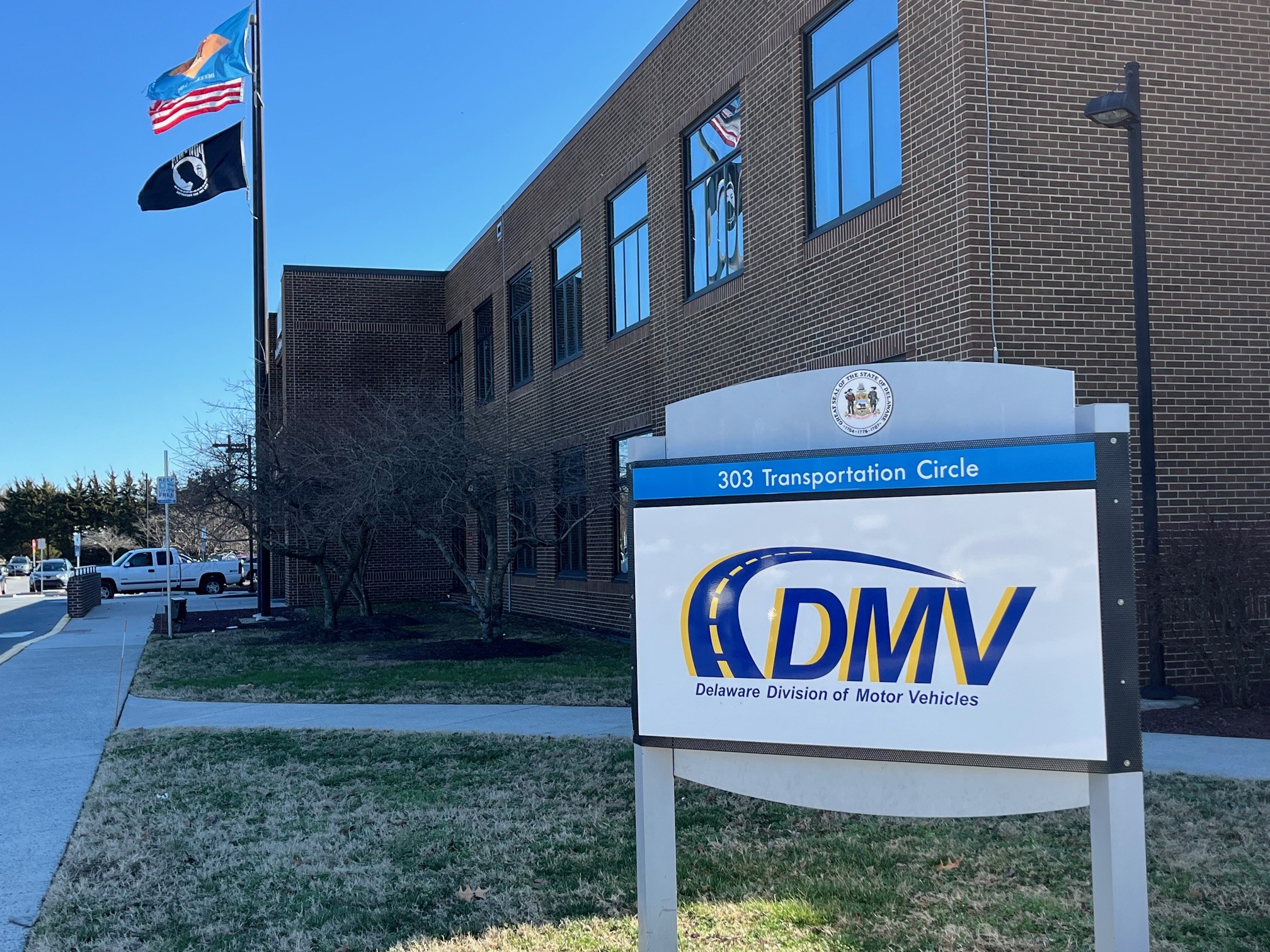
DOVER — Enhanced security protocols have been launched across all Delaware Division of Motor Vehicles facilities this week, requiring visitors to undergo screening before conducting business.
All individuals entering DMV offices must now walk through metal detection equipment that is monitored by private security personnel. The state agency has also modified procedures for how people enter and leave these government buildings.
The new safety measures represent a significant change for Delaware residents visiting DMV locations to handle vehicle registrations, license renewals, and other motor vehicle services.
A Delaware athlete is making waves at the Paralympics as he pursues what could be a historic first for Team USA in wheelchair curling.
Steve Emt, competing in his third Paralympic Games, has teamed up with Laura Dwyer to represent the United States in the newly introduced mixed doubles wheelchair curling competition. The pair recently secured a victory against Italy during Sunday’s match, keeping their medal hopes alive.
This Paralympic appearance marks a significant milestone for American wheelchair curling, as Emt and Dwyer have the opportunity to capture the nation’s inaugural medal in the sport. The mixed doubles format represents a fresh addition to the Paralympic program, giving athletes like Emt a new avenue to compete for Paralympic glory.
Emt’s journey to his third Paralympics demonstrates the dedication and skill required to compete at the sport’s highest level. His partnership with Dwyer has proven successful in early competition, setting up what could be a breakthrough moment for wheelchair curling in the United States.
The Delaware competitor’s pursuit of Paralympic history continues as the mixed doubles tournament progresses, with American fans hoping to witness their first wheelchair curling medal ceremony.
Federal meteorologists are seeking every available piece of data when dangerous winter conditions threaten lives, prompting them to issue critical safety alerts. Among winter’s many dangers, wind-driven snow represents a frequently underestimated yet serious risk to public safety.
This weather phenomenon occurs when powerful winds pick up snow that has previously accumulated on the ground, lifting it back into the air. The result can be an immediate drop in visibility to virtually nothing, creating dangerous conditions for anyone traveling by car or plane.
Weather forecasters are now combining satellite observations with citizen reports to improve their ability to identify these hazardous conditions before they become life-threatening emergencies.
A traffic accident has prompted officials to shut down a section of Carpenter Bridge Road, blocking vehicle access between Jackson Ditch Road and Campground Road.
The roadway closure is currently in effect as emergency personnel and cleanup crews respond to the collision scene. Motorists are advised to seek alternate routes until the road reopens.
No additional details about the crash have been released at this time, including information about potential injuries or the number of vehicles involved in the incident.
Maryland agriculture officials have identified a suspected outbreak of deadly bird flu at a commercial poultry facility in Cecil County, marking the first detection of the disease in the area this year.
The Maryland Department of Agriculture revealed on March 12, 2025, that preliminary tests showed a presumptive positive result for H5 Avian Influenza at the pullet farm. Officials confirmed this represents the initial case of Highly Pathogenic H5 Avian Influenza (HPAI) detected in Cecil County during 2025, and the fifth case reported statewide.
The announcement came from the state agriculture department’s headquarters in Annapolis, as officials continue monitoring the situation at the affected commercial operation.
NEW CASTLE, Del. — Flames engulfed a barge loaded with scrap metal Tuesday morning as it traveled through Delaware Bay waters, prompting a multi-agency emergency response.
Coast Guard units launched shortly after 8 a.m. following initial reports of the blaze, deploying one helicopter and two watercraft to the scene, according to Petty Officer First Class Matthew West. Fire departments from the area also joined the response effort. The unmanned vessel was being pulled by a tugboat when the flames ignited, West reported, noting that no one was hurt in the incident.
Maritime traffic continued moving normally despite the ongoing emergency, West confirmed. Hours after the initial outbreak, the fire continued to burn as the barge remained stationary in the water. Emergency boats positioned on either side of the vessel directed powerful water streams at the blazing metal heaps while thick smoke poured from multiple fire locations across the deck.
Investigators have not yet determined what sparked the blaze, West stated.
Motorists are being advised to find alternate routes as southbound US Route 13 has been completely shut down at Old North Road due to a vehicle accident.
Delaware Department of Transportation officials report the crash has made the roadway impassable in that direction. Emergency crews are currently working at the scene to clear the incident.
No timeline has been provided for when the road will reopen to traffic. Drivers are encouraged to seek alternative routes until further notice.
New Castle County police have activated a Gold Alert as they search for a 29-year-old local resident who has been missing since Tuesday morning.
Shane Roane was last spotted in the Hollaway Terrace area along the 400 block of Tenth Street at approximately 7:00 a.m. on March 10, 2026, according to the New Castle County Division of Police.
Law enforcement officials report they have conducted thorough search operations but have not succeeded in finding or making contact with Roane since his disappearance.
The Gold Alert system is used by police to notify the public when adults who may be vulnerable go missing under concerning circumstances.
Anyone with information about Shane Roane’s whereabouts is urged to contact the New Castle County Division of Police immediately.
The University of Delaware baseball squad is set to embark on their first Conference USA matchup as they travel west to face Louisiana Tech in what promises to be a historic series for the program.
This upcoming series represents a major transition for the Blue Hens athletics program as they enter their inaugural season as members of Conference USA, marking a new chapter in the university’s competitive landscape.
The road trip to Louisiana will test the team’s ability to perform away from home as they adjust to the heightened level of competition that comes with their new conference affiliation.
Delaware’s baseball program is looking to make a strong impression in their Conference USA debut, as they work to establish themselves among the established programs in their new athletic home.
Rehoboth Beach commissioners moved forward with their fiscal year 2027 budget planning during Monday’s fourth budget session, approving all nonprofit funding requests that came before them.
The city is developing its budget for the fiscal year that starts April 1, 2026, and Monday’s March 9 meeting centered on allocating funds to community organizations.
Commissioners gave their approval to funding requests from five local nonprofits, with the largest allocation going to the Rehoboth Beach Volunteer Fire Company at $300,000. The Rehoboth Beach Public Library and CAMP Rehoboth each received approval for $75,000 in funding.
Both Rehoboth Beach Main Street and the Rehoboth Beach Historical Society were approved for $60,000 each, though the historical society had initially requested $52,000.
City officials also examined potential changes to building permit extension fees for projects extending past 12 months. While no new policies were introduced, commissioners reviewed updated fee proposals based on recommendations from previous budget discussions. This matter will be addressed again in future meetings as the city continues evaluating the most effective renewal structure.
Commissioners additionally addressed personnel matters, including whether to implement merit increases or merit bonuses for city employees, and discussed the Paid Family Leave Tax.
The city will hold its final budget approval session on March 20, 2026.
Young anglers across Maryland will have more opportunities than ever to cast their lines in 2026, as the state’s Department of Natural Resources prepares to host a record-breaking 55 free youth fishing events statewide.
The program welcomes children and teenagers between 3 and 15 years old who want to learn fishing techniques or improve their angling abilities at these no-cost events spanning from March to October.
“This is the largest number of events DNR has supported through the youth rodeo program,” said Youth Rodeo Coordinator Devin Baker. “We’re gearing up to stock 2,900 hybrid sunfish, 1,400 channel catfish, and 5,250 rainbow trout for events across 15 counties.”
The state agency has partnered with numerous organizations to deliver these educational fishing experiences to thousands of young people throughout the year. A significant portion of these gatherings will take place at Maryland State Parks and other publicly accessible locations.
These youth-focused fishing competitions have deep roots in Maryland’s history, with some events dating back more than six decades. The program aims to create secure learning environments where children can master fundamental fishing techniques while developing a commitment to protecting natural resources. Federal funding from the U.S. Fish and Wildlife Service Wildlife and Sport Fish Restoration Program helps support Maryland’s youth fishing initiative.
Last year’s program successfully engaged over 4,000 young participants across 51 separate events. Officials anticipate surpassing that participation figure in 2026.
Families can access a detailed breakdown of upcoming fishing events organized by county through the department’s online schedule.
Although these fishing events are completely free and welcome all participants, certain locations may have capacity restrictions. Parents and guardians should visit the department’s website and use the provided contact information to secure registration. It’s also recommended to verify event status for any potential changes or postponements.
Youth under 16 are exempt from fishing license requirements. However, adults and teenagers can obtain licenses through online purchasing or by visiting authorized dealers. Revenue from license sales, along with purchases of fishing equipment, ammunition, watercraft, and marine fuel, directly supports the state’s fish and wildlife conservation efforts.
Delaware State Police are conducting an investigation following a shooting incident that took place Wednesday afternoon in Greenwood during a warrant operation.
At around 1:30 p.m. on March 11, 2026, multiple Delaware State Police units responded to the 11000 block of Wheatfield Road in Greenwood to carry out a search warrant and arrest 60-year-old Jeffrey Mitchem. The response team included officers from the Sex Offender Apprehension and Registration (SOAR) Unit, Troop 4 Criminal Investigations Unit, and the Special Operations Response Team (SORT). The FBI’s National Threat Operations Center had alerted DSP earlier that day about menacing online messages posted by Mitchem. He had also transmitted a photograph showing himself with what looked like a black handgun to a State Police SOAR detective, accompanied by an image of a coffin. Mitchem was also sought by Arlington County Police Department in Virginia on charges of felony terroristic threatening.
Upon arrival, officers found that Mitchem had locked himself inside his camper and would not comply with orders to exit. The DSP Crisis Management Team made contact with Mitchem, but he continuously rejected surrender demands and claimed he possessed a significant quantity of gunpowder while holding a detonation trigger. Officers observed Mitchem scattering what looked like an unidentified powder throughout the camper interior, and he concealed one hand when appearing at the doorway, lending credibility to his explosive threats.
An officer discharged one round, striking Mitchem in the arm. After being shot, Mitchem discarded a handgun from the camper, came outside, and was arrested without additional resistance. Officers administered medical aid until paramedics arrived, and he was transported to a local hospital with serious injuries.
Following standard Delaware State Police protocols for shootings involving officers, the Homicide Unit has taken over the investigation. Initial findings by detectives revealed that the black handgun Mitchem had thrown from the camper was actually an airsoft replica of a Walther PPS M2 firearm. During the camper search, investigators discovered that Mitchem had positioned a 6.5-inch wooden-handled hunting knife on a shelf near the entrance where he had been standing before his arrest. Due to previous felony convictions, Mitchem is legally forbidden from possessing deadly weapons. The DSP Explosive Ordnance Disposal team verified that the mysterious powder was not explosive material.
Mitchem continues to receive hospital treatment. He faces multiple charges, was processed through Justice of the Peace Court 11, and was remanded to Delaware Department of Correction custody with a $43,000 secured bond.
The charges against Mitchem include:
• Possession of a Deadly Weapon by a Person Prohibited (Felony) • Intent Threaten the Life of or Threatens Severe Physical Injury to Public Official or Public Servant (Felony) – 19 counts • Resisting Arrest
The officer involved in the shooting has been assigned to administrative leave pending a use-of-force review conducted jointly with the Delaware Department of Justice’s Division of Civil Rights and Public Trust.
The investigation remains ongoing, and detectives encourage anyone with relevant information to contact Detective M. Csapo at (302) 741-2729. Tips can also be submitted through private Facebook messages to the Delaware State Police or by calling Delaware Crime Stoppers at 1-800-847-3333.
Crime victims, witnesses, or those who have lost loved ones to sudden death can access support through the Delaware State Police Victim Services Unit and Delaware Victim Center, available 24/7 at 1-800-VICTIM-1 (1-800-842-8461) or via email at [email protected].
Delaware Department of Transportation officials have blocked traffic on Walnut Shade Road after electrical wires came down across the pavement.
The road closure affects both lanes of traffic traveling between Upper King Road and Route 13 while crews work to clear the hazardous power lines from the roadway.
Motorists should seek alternate routes and avoid the area until DelDOT announces the road has been safely reopened to traffic.
The Delaware State University women’s basketball team came up short in their battle against the University of Maryland Eastern Shore, falling by a score of 55-48 in conference action.
The Hornets showed determination throughout the contest but were unable to generate enough offensive production to secure a victory over their MEAC rivals. The seven-point margin reflected a competitive game between the two teams.
Delaware State’s efforts on the court were not sufficient to overcome UMES, as the Hawks managed to pull away for the win in what proved to be a hard-fought conference battle.
A University of Delaware field hockey standout has earned a coveted spot on the United States Under-21 Women’s National Team.
Junior player Sarah Rigual was selected for the roster that will compete in the 2026 Junior Pan American Championship, according to an announcement made Wednesday by USA Field Hockey officials in Colorado Springs, Colorado.
The recognition marks a significant achievement for the Blue Hens athlete, who will now represent her country in the upcoming international competition known as JPAC.
Delaware lawmakers have passed legislation requiring every school district and charter school in the state to establish comprehensive policies governing student cell phone usage during school hours.
Under the new law, educational institutions must collaborate with teachers and staff to develop policies that include six key components. Schools must establish clear standards for appropriate cell phone usage on campus and implement restrictions on device use during classroom instruction.
The legislation also mandates that schools designate specific times and locations where students are permitted to use their mobile devices. Additionally, policies must promote dialogue between educational institutions, families, and students regarding cell phone regulations.
Each policy must outline a framework of suitable penalties for students who violate the cell phone rules. However, schools must also include provisions for emergency circumstances and students requiring medical or educational accommodations.
All Delaware school districts and charter schools have until August 1, 2025, to submit their policies to the state Department of Education and publish them on their official websites. Educational institutions retain the flexibility to modify their cell phone policies as circumstances require, but any revisions must be reported to the Department and updated online.
Delaware’s three counties will soon have enhanced legal authority to gather evidence when assessing property values for taxation purposes, following the passage of new legislation that strengthens their subpoena powers.
The measure, which serves as a replacement for Senate Bill 230, grants specific authority to county finance leaders to demand testimony and documents during property valuation disputes. Under the new law, this power applies specifically when counties use income-based or cost comparison methods to determine a property’s fair market value.
The legislation identifies three key officials who can exercise these expanded powers: the Chief Financial Officer of the Office of Finance, Kent County’s Department of Finance Director, and Sussex County’s Finance Director.
When property owners challenge tax assessments or when counties need to defend their valuation methods, these officials can now compel individuals and businesses to provide testimony and produce relevant documents. If someone refuses to comply with a subpoena, the Superior Court has the authority to enforce the order and can use contempt of court powers against non-compliant parties.
The final version of the bill differs from the original Senate proposal by removing provisions that would have affected Section 284 of Delaware’s General Corporation Law, focusing the legislation specifically on county assessment authority.
Delaware Department of Transportation maintenance teams are conducting litter removal operations along a stretch of Interstate 495 connecting Newport and Claymont today.
The cleanup work is taking place on both the northbound shoulder area and the southbound median strip, with crews scheduled to complete their efforts by 5 PM this afternoon.
Motorists traveling through this section of I-495 may encounter slower traffic or lane restrictions while the maintenance operation is underway.
Delaware Department of Transportation officials have temporarily shut down Exit 148 on southbound Route 1 following a vehicle collision.
The exit closure is currently in effect as emergency responders and cleanup crews work to clear the accident scene and ensure roadway safety.
Drivers traveling southbound on Route 1 should plan for delays and consider using alternative routes to reach their destinations while the exit remains blocked.
DelDOT has not yet provided an estimated timeline for when the exit will reopen to traffic.
Salisbury University’s track and field athletes have received major recognition following an outstanding indoor season performance.
The U.S. Track & Field and Cross Country Coaches Association revealed yesterday that 16 Sea Gulls earned All-Region recognition for the 2026 NCAA Division III Indoor Track & Field campaign. The impressive showing placed these student-athletes on the Mid-Atlantic regional team.
The announcement from New Orleans highlights the strength of Salisbury University’s track and field program during the recently concluded indoor competition season. The USTFCCCA selections recognize top performers across various events throughout the region.
NEWARK, Del. – The University of Delaware women’s soccer program has elevated a key staff member to a higher position within the coaching ranks.
Head coach Kelly Lawrence announced Wednesday that Shannon Coley will take on the role of associate head coach, marking a significant step up for the longtime Blue Hens assistant.
Coley has served as an essential member of Delaware’s women’s soccer coaching staff for the past three seasons, helping guide the program through recent campaigns.
The promotion reflects Coley’s growing influence and contributions to the Blue Hens soccer program as Lawrence continues to build her coaching structure in Newark.
The Delaware State University women’s tennis squad put up a strong fight but ultimately fell to Towson University in a narrow 4-3 defeat on Saturday, March 7 in Towson, Maryland.
The Hornets showed resilience throughout the competitive match, managing to secure three victories against their opponents. Despite their determined effort, DSU was unable to overcome Towson’s slight edge in the closely contested battle.
The loss highlights the competitive nature of collegiate tennis, where matches can be decided by the smallest of margins. The Delaware State women’s tennis program continues to demonstrate their ability to compete at a high level against quality opposition.
A forgotten backpack outside the Dover Division of Motor Vehicles office led to a temporary evacuation Tuesday morning while authorities investigated the suspicious item.
Delaware Capitol Police launched their investigation after a DMV worker spotted the unattended package outside the Dover facility. Law enforcement officers arrived on scene and confirmed the presence of the suspicious item, leading to the precautionary evacuation of staff and customers from the building.
The Delaware State Police Explosive Ordnance Disposal team was called in to examine the package. After determining it posed no threat, officials gave the all-clear for people to return inside.
Police investigators were able to track down the person responsible for leaving the backpack. Their investigation revealed the individual had visited the DMV location the day before to conduct routine business and accidentally left the bag behind.
Authorities now believe the backpack was simply forgotten and found no indication of malicious intent or any attempt to disrupt DMV operations.
The incident began around 11:45 a.m. when police first responded to the scene. The DMV office was able to resume normal operations by approximately 1:30 p.m.
Winter weather conditions are impacting New Castle County as snowfall with different levels of intensity has been reported throughout the area.
Delaware Department of Transportation officials are urging drivers to exercise extra caution while traveling on county roads during the ongoing snow event.
The varying degrees of snowfall intensity across different parts of New Castle County may create unpredictable driving conditions for motorists.
Residents are encouraged to allow additional travel time and maintain safe following distances while the winter weather persists in the region.
Good evening, Delmarva! We’re wrapping up Tuesday with some pleasant conditions across the peninsula tonight. Expect mostly clear skies with temperatures settling around a comfortable 53 degrees. Light south winds at about 5 mph will keep things calm and peaceful.
Looking ahead to Wednesday, we’ll see a nice start to the day with mostly sunny skies and temperatures climbing to a beautiful 77 degrees – perfect spring weather! However, don’t let that sunshine fool you completely. We’re tracking changes moving in as we head into Wednesday evening, with a slight chance of rain showers developing.
The weather pattern shifts more significantly Wednesday night into Thursday. Those shower chances increase, and we could see some thunderstorms rolling through the area. Temperatures will drop back to around 53 degrees Wednesday night, then rise to 59 Thursday as rain showers become likely.
Bottom line: enjoy that gorgeous Wednesday weather, but keep the umbrella handy for later in the week. Stay weather-aware, Delmarva, and have a wonderful evening!
Drivers traveling on Interstate 95 northbound are experiencing significant delays after a vehicle accident forced the closure of two right lanes at the Southern Split location.
According to Delaware Department of Transportation officials, the crash has blocked traffic in the right lanes, creating a bottleneck for commuters during what is typically a busy travel corridor.
Authorities are working to clear the scene and restore normal traffic flow. Motorists are advised to allow extra travel time and consider using alternative routes when possible.
No additional details about the nature of the accident or any potential injuries have been released at this time.
Motorists traveling eastbound on Harmons Hill Road, also known as Route 302, are encountering traffic delays due to a construction-related lane closure today.
The affected stretch runs between Indian Mission Road (Routes 5/23) and Hollyville Road, with the lane restriction scheduled to remain in place until 4:30 PM this afternoon.
Drivers are advised to allow extra travel time and consider alternate routes if possible to avoid potential delays in the area.
Traffic is at a standstill on northbound Route 1 near Exit 114 after a vehicle caught fire, prompting authorities to shut down both lanes of the highway.
The Delaware Department of Transportation is monitoring the situation and has issued alerts about the closure through their traffic incident reporting system.
Motorists traveling north on Route 1 should expect significant delays and are advised to seek alternate routes while emergency crews work to clear the scene and extinguish the vehicle fire.
No additional details about the cause of the fire or potential injuries have been released at this time.
SOUTHERN CALIFORNIA — Before spring officially arrives next week, residents across Southern California are experiencing summer-like conditions as meteorologists forecast extraordinarily high temperatures, with some areas expected to reach the mid-90s near Los Angeles.
Thursday and Friday will bring temperatures approximately 20 degrees above typical mid-March levels, according to the National Weather Service. Health officials are warning residents about increased risks of heat-related illnesses and recommending people stay well-hydrated while limiting outdoor activities during peak daylight hours.
This unusual winter heat surge results from a high-pressure system combined with an absence of the typical cooling ocean breezes from the Pacific, explained Bryan Lewis, a National Weather Service meteorologist stationed in Los Angeles.
“The nation’s air conditioner, as we like to call it, is essentially shut off right now,” Lewis said Thursday. “We’ll likely tie or break several temperature records all across LA County.”
Thursday is anticipated to be the most intense day of heat in the Los Angeles area, with thermometers potentially reaching 93 degrees in the downtown core and climbing to 95 degrees throughout the San Fernando Valley. Normal temperatures for this time of year hover around 70 degrees.
Construction crews working outdoors are being provided with ample drinking water and electrolyte supplements to prevent dehydration. Companies are mandating regular rest periods, according to Junior Pineda, who represents a local chapter of the International Union of Bricklayers & Allied Craftworkers.
“And there’s always shade structures, if guys start feeling a little light-headed and need to take a few minutes,” he said Wednesday.
Both Los Angeles city and county authorities have arranged to open cooling centers to assist residents who lack air conditioning in their homes.
Zack Marquez, a wheelchair user, was completing his errands Wednesday in LA’s Koreatown district before the temperature climbed too high.
“Gotta stay hydrated and stay in the shade,” he said.
Coastal areas may experience some relief Friday when ocean breezes return, though interior regions will continue experiencing sweltering conditions, weather forecasters predict.
Hollywood celebrities are arriving in Los Angeles for Sunday’s Academy Awards ceremony, with numerous events scheduled throughout the week to capitalize on the gathering of entertainment industry stars. However, the extreme heat should subside before the awards show takes place.
Other parts of California will also experience above-average temperatures beginning next week. The San Francisco Bay Area and Sacramento region could see temperatures exceeding 90 degrees by Monday.
Salisbury officials have announced that the pedestrian bridge connecting to the Pohanka Riverwalk Amphitheater has reopened, restoring an important walkway link for community members and tourists visiting the area.
The bridge’s return comes at an ideal time as spring weather approaches and the city prepares for its busy season of outdoor events and activities. The walkway now provides uninterrupted access between The Ross, the Pohanka Riverwalk Amphitheater, and the recently renovated DoubleTree by Hilton Hotel along with Savour restaurant located at 300 S. Salisbury Blvd.
Several beloved community events are scheduled to return this spring, including the annual Hops on the River celebration on April 25 and the launch of this year’s 3rd Friday festivities, which will begin with a special tribute to Salisbury University’s centennial anniversary. The United Way will once again organize the Over the Edge for ALICE event at The Ross on May 8.
City officials plan to present an impressive roster of musical acts at the Pohanka Riverwalk Amphitheater during the summer months as part of the Friday Night Live concert series. Now that the pedestrian bridge has reopened, getting to parking areas for amphitheater shows and private events will be much easier.
“We’re excited to welcome the community back to this beautiful space,” Mayor Randy Taylor said. “The amphitheater is an affordable, rentable venue that brings people together. We hope residents and organizations will take advantage of this unique setting for their events.”
Community groups can still reserve the amphitheater for their own gatherings. Additional details can be found at Salisbury.md/citizen-services.
Two public events are already scheduled at the Pohanka Riverwalk Amphitheater:
Flying Ivories: Dueling Pianos featuring VIP options available on May 9 from 6 to 9 p.m.
The Great Train Robbery a complimentary event set for May 22 from 6 to 9 p.m.
Visitors are encouraged to explore the entire Riverwalk area during their visit. With spring approaching, the season for outdoor events is officially beginning, and more announcements are expected soon.
Worcester County has announced that the Mystic Harbour Water & Wastewater Advisory Board will convene for a scheduled meeting this Friday, March 6th, beginning at 2:00 PM.
County officials have made the meeting agenda available to the public through their official website. The agenda document, dated March 6, 2026, can be accessed as a PDF file for residents who wish to review the topics that will be discussed during the session.
The advisory board meeting was posted to the county’s event calendar on Thursday, March 12th at 12:47 PM by county staff member ctunnell. Community members interested in attending or following the proceedings can find additional information through Worcester County’s online events calendar.
The Ocean Pines Water and Wastewater Advisory Board has announced an upcoming meeting scheduled for Tuesday, January 13, 2026, beginning at 9:00 AM.
Meeting minutes from the session will be made available following the conclusion of the board’s proceedings. The advisory board regularly convenes to discuss water and wastewater infrastructure matters affecting the Ocean Pines community.
Residents interested in the board’s activities can access meeting information through Worcester County’s official events calendar.
University of Maryland Eastern Shore basketball standout Zion Obanla has earned recognition as a member of the All-MEAC Second Team, the conference announced.
The honor recognizes Obanla’s exceptional contributions to the Hawks basketball program throughout the season. The All-MEAC teams celebrate the top performers across the Mid-Eastern Athletic Conference.
Obanla’s selection to the second team represents a significant achievement for both the player and the UMES basketball program. The recognition comes as the conference acknowledges the season’s most outstanding student-athletes.
The University of Maryland Eastern Shore Hawks compete in the MEAC, where Obanla has established himself as one of the conference’s top talents during his collegiate career.
Educators from Delaware State University’s College of Education recently traveled to Arlington, Virginia to participate in a pair of prominent national academic conferences.
The DSU faculty members shared their research findings and educational expertise with peers from universities nationwide during the Virginia events. The conferences provided opportunities for the professors to present their work and engage with other education professionals on current trends and developments in the field.
The participation of Delaware State University’s education faculty at these national gatherings demonstrates the institution’s commitment to scholarly research and professional development within the academic community.
Delaware Department of Transportation crews are currently conducting litter removal activities along the median area of Interstate 95 southbound near Exit 4A.
The cleanup operation began earlier today and is expected to wrap up by 4:30 PM this afternoon.
Motorists traveling through the area should expect to see DelDOT vehicles and workers along the roadway during the cleanup efforts.
The First State is ramping up efforts to improve early reading education with a substantial financial commitment exceeding $8 million aimed at enhancing literacy instruction in schools statewide.
State education officials revealed today that Delaware has secured significant funding through two major sources to support this educational initiative. The funding package includes a $1.9 million State Implementation Fund grant provided by Accelerate, along with an additional $6.1 million in competitive Bridge funding.
This comprehensive investment represents Delaware’s commitment to strengthening foundational reading skills among young students through improved classroom instruction methods and resources.
The Delaware Department of Education emphasized that these coordinated investments will work together to advance the state’s comprehensive approach to early literacy education across all participating schools.
Delaware Department of Transportation officials have implemented reduced speed limits on Interstate 495, bringing the maximum allowable speed down to 55 miles per hour due to adverse weather conditions affecting the area.
The temporary speed reduction has been put in place as a safety measure for motorists traveling along the highway during current weather patterns impacting the region.
Drivers are advised to exercise caution and follow the posted speed limits while traveling on I-495 until conditions improve and normal speed limits are restored.
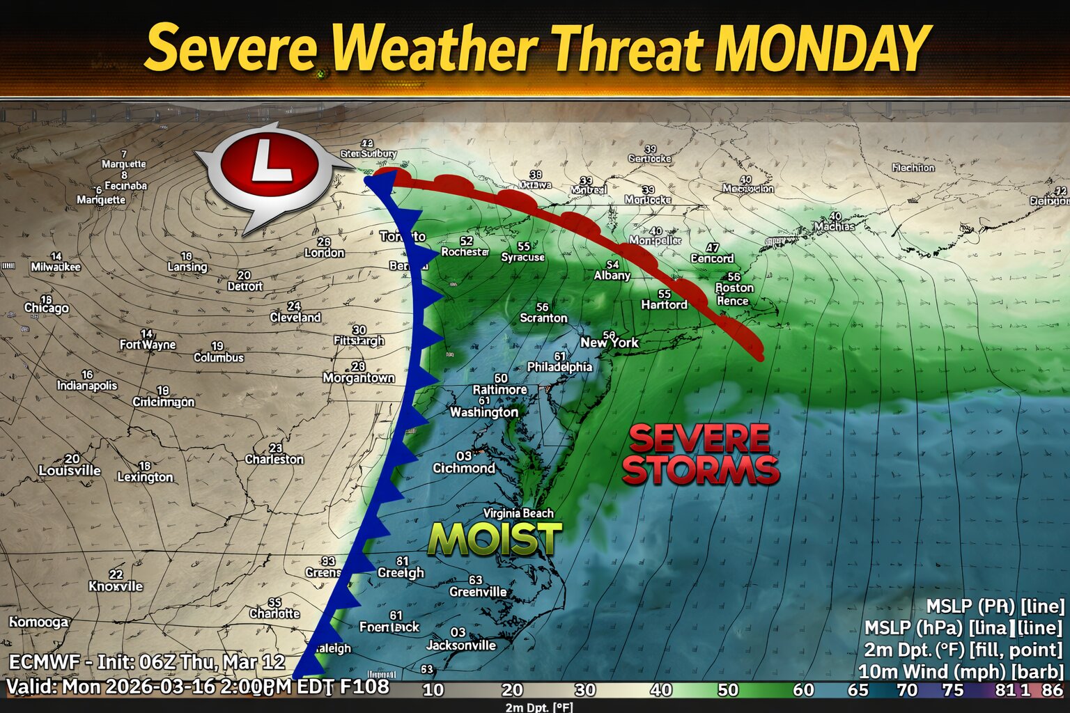
A strong storm system moving from the Mississippi Valley toward the East Coast could bring the potential for severe thunderstorms across parts of the Mid Atlantic on Monday.
Ahead of an approaching cold front, warm and humid air will surge northward with dew points climbing into the 60s. At the same time, strong southwesterly winds throughout the atmosphere will overspread the region, creating favorable conditions for organized thunderstorms.
The primary threat appears to be a line of thunderstorms developing along the advancing cold front, which could produce damaging wind gusts as it moves east through the region. Even though atmospheric instability may remain somewhat limited, the strength of the storm system and strong forcing along the front could still support severe weather.
There is also a more uncertain risk for isolated supercell thunderstorms ahead of the main line, particularly across parts of eastern Virginia and North Carolina where low level wind shear may be enhanced.
The Storm Prediction Center have highlighted portions of the Mid Atlantic with a 15 percent severe weather risk Monday, mainly due to the potential for damaging winds with the line of storms. Cloud cover and early day showers may limit instability, which could affect the overall severity of the storms.
PHILADELPHIA – The Blue Hens baseball squad claimed their inaugural away victory of the season Tuesday evening, defeating Penn 5-3 in Philadelphia competition.
Delaware’s triumph represents a significant achievement for the program as they notched their first successful road contest of the current campaign against the Quakers.
The Blue Hens managed to secure the win with a two-run margin, demonstrating solid performance in enemy territory to start building momentum for upcoming contests.
Four University of Maryland Eastern Shore women’s basketball players received recognition from the Mid-Eastern Athletic Conference for their outstanding regular season performances.
Lynch secured spots on both the First Team and All-Defensive Team, highlighting her impact on both ends of the court throughout the season. Meanwhile, newcomers Perry and Taylor both earned places on the All-Rookie Team for their impressive debut campaigns.
Barnes was honored as the Sixth Player of the Year, recognizing her valuable contributions coming off the bench for the Hawks this season.
The awards reflect the strong season put together by the UMES women’s basketball program, with multiple players earning conference-wide recognition for their individual achievements during regular season play.
Drivers traveling on northbound Interstate 95 should expect delays as construction crews continue working overnight between exits 4 and 5.
Delaware Department of Transportation officials report that the two rightmost lanes are currently blocked off for ongoing construction activities. The lane closures are expected to remain in effect until 6 a.m.
Motorists are advised to allow extra travel time and use caution when driving through the work zone area.
A dramatic change in the weather is unfolding across the Delmarva region today as a strong cold front moves offshore, bringing gusty winds, falling temperatures, and the potential for rain to mix with wet snow later in the day.
The region began the morning unusually warm, with temperatures starting in the 60s and even low 70s in some areas. However, strong cold air advection behind the departing cold front is causing temperatures to steadily fall through the day. Readings will drop through the 50s and 40s during the morning before settling into the mid to upper 30s by this afternoon.
Periods of showers are expected early today. As the atmosphere continues to cool, an area of additional moisture will develop behind the front as a disturbance rides along the temperature boundary offshore. This will cause rain to expand across much of the region through the late morning and afternoon hours.
As colder air deepens across the Mid-Atlantic, rain may begin mixing with wet snow, and in some places could briefly change over to all snow during the afternoon. This scenario is most likely near and southeast of the I-95 corridor, which includes much of Delaware and Maryland’s Eastern Shore.
If a band of stronger lift develops later this afternoon, precipitation could briefly intensify. This would allow the atmosphere to cool more quickly and may lead to a faster transition from rain to snow for a short period.
Despite the possibility of wet snow, little to no accumulation is expected. The recent stretch of record warmth has left ground temperatures elevated, and air temperatures during the day will remain above freezing. At most, minor slushy accumulation could briefly occur on grassy or elevated surfaces during heavier bursts of precipitation, while roads should remain mainly wet. But the chances of that are quite low.
In addition to the falling temperatures, winds will become quite gusty behind the front. Strong mixing in the atmosphere will allow winds to gust between 30 and 40 mph at times today, especially during the morning hours immediately behind the frontal passage. These winds will add to the chill as temperatures continue to fall through the afternoon.
By late day, wind chills are expected to drop into the upper 20s to low 30s, creating a sharp contrast from the mild conditions experienced just yesterday. In fact, temperatures this afternoon will be roughly 40 to 50 degrees colder than yesterday afternoon across parts of the region.
Precipitation should taper off from west to east by late afternoon into early evening as the system pulls away. Skies may begin to clear tonight, although a few lingering snow showers cannot be ruled out in parts of northeastern Pennsylvania.
Temperatures tonight will fall into the upper 20s across much of the region as winds gradually diminish, bringing a cold end to what began as a very mild start to the day.
A section of the Georgetown to Lewes Trail will be temporarily shut down this week as crews perform tree removal operations, according to the Delaware Department of Transportation.
The trail closure will affect the stretch running from Cool Spring Road to Savannah Road beginning Monday, March 16th and continuing through Friday, March 20th. Work is scheduled to take place between 8 a.m. and 5 p.m. each day, with completion dependent on favorable weather conditions.
Trail users seeking additional details can access DelDOT’s website at www.deldot.gov for updates on the tree clearing project.
Maryland officials have given final approval to new recreational striped bass fishing regulations that will reshape when anglers can target the popular species in Chesapeake Bay waters.
The Maryland General Assembly’s Joint Committee on Administrative, Executive, and Legislative Review approved the Department of Natural Resources’ proposed changes on Wednesday. The updated rules will take effect March 30, ten days after publication in the Maryland Register on March 20.
Under the revised regulations, April will reopen for catch-and-release striped bass fishing, while the entire month of August will be off-limits for targeting the fish. Officials say the timing shift protects striped bass during late summer heat when warmer water temperatures increase the likelihood of fish dying even after being released.
The 2026 recreational striped bass season in Chesapeake Bay will operate as follows:
January 1–April 30: Catch and Release
May 1–July 31: Harvest
August 1–31: Closed
September 1–December 5: Harvest
December 6–31: Catch and Release
Kate Charbonneau, DNR’s Assistant Secretary of Aquatic Resources, explained the rationale behind the changes. “The new regulations simplify the recreational and charter boat seasons, making them easier to find and read,” Charbonneau said. “We are allowing for more access to recreational fishing opportunities without increasing mortality or total fish removed.”
The regulatory overhaul follows more than a year of deliberation and extensive public input, including review of thousands of comments from stakeholders. Striped bass fishing ranks among Maryland’s most popular recreational activities, with recreational fishing and boating contributing an estimated $701.5 million in economic value to the state during 2024, according to federal Bureau of Economic Analysis data.
The seasonal adjustment addresses a specific conservation concern. During hot August weather, young resident striped bass become more susceptible to mortality even when caught and released by anglers. Data from the most recent stock assessment shows that recreational dead discards—fish that die after being caught and returned to the water—accounted for 21% of all fishing-related striped bass deaths in the Bay.
Previous regulations prohibited all striped bass targeting from April 1 to May 15 and July 16 to July 31, along with additional closures in specific tributaries. The new approach consolidates the closure period into August while reopening April for catch-and-release activities when cooler water temperatures improve fish survival rates.
When harvest is permitted, anglers may keep one striped bass per person daily, measuring between 19 and 24 inches in length. During catch-and-release periods, officials urge anglers to use techniques that maximize fish survival, including minimal handling and reduced air exposure.
Ocean waters remain open year-round for striped bass fishing with different size limits—fish must measure between 28 and 31 inches, with a one-fish daily limit. Spawning rivers will continue their March 1 to May 31 closure to protect breeding fish.
The regulatory changes come amid ongoing concerns about striped bass population health. Despite increases in large coastal spawning fish in recent years, Maryland’s juvenile striped bass surveys have documented seven consecutive years of poor recruitment in state waters. Scientists continue investigating factors that may be affecting young striped bass survival.
Current adult rockfish populations remain large enough to produce strong juvenile year classes under favorable environmental conditions. However, fisheries experts warn that the impacts of diminished juvenile recruitment will likely become more pronounced as these smaller year classes reach maturity.
The August closure specifically targets protection of resident striped bass during their most vulnerable period. Hot late-summer conditions make younger resident fish particularly susceptible to mortality, and the closure aims to help these fish grow and eventually migrate from the Chesapeake Bay to join the spawning population.
Officials anticipate the seasonal shift will benefit both recreational anglers and related businesses by restoring spring fishing opportunities while moving the closure to August, when other species like red drum remain available for targeting.
During the August striped bass closure, DNR encourages anglers to pursue invasive species including blue catfish and Chesapeake Channa (snakehead). These invasive fish have no bag or size limits, and their removal benefits Bay ecosystem health.
All striped bass fishing requires a valid Maryland fishing license, available online through MD Outdoors, at DNR service centers, or through licensed retailers. License sales, along with tackle, boat, and marine fuel purchases, fund the department’s fish conservation efforts.
Young fishing enthusiasts will have exclusive access to New Castle County’s trout-stocked streams this spring, with Delaware’s Department of Natural Resources and Environmental Control setting aside April 4 as a youth-only fishing opportunity.
The special day for anglers under 16 years old will begin at 7 a.m. on Saturday, giving young fishermen and women the first chance at the 2026 trout season. Adult anglers will need to wait until the following morning, when the regular season opens for everyone thirty minutes prior to sunrise on Sunday, April 5.
This youth-focused initiative gives Delaware’s youngest outdoor enthusiasts a head start on the popular upstate trout fishing season, which draws anglers to freshwater streams throughout New Castle County each spring.
Delaware Department of Transportation crews are working to clear debris from Interstate 495 southbound, causing lane restrictions for drivers approaching New Castle Avenue.
The right lane remains blocked as crews remove the roadway obstruction, creating potential delays for evening commuters. Motorists traveling southbound on I-495 should expect slower traffic conditions in the area.
DelDOT has not provided an estimated time for when the lane will fully reopen to traffic. Drivers are advised to use caution when passing through the work zone and consider alternate routes if possible.
Drivers using Coastal Highway (Route 1) near Ocean City are experiencing traffic disruptions due to ongoing construction work that has forced the closure of the right shoulder.
The Delaware Department of Transportation reports that the shoulder closure affects the stretch of highway between Inlet Road and South Inlet Road, specifically near Access Road B. The restriction is expected to remain in effect until 1 PM today.
Motorists are advised to allow extra travel time and exercise caution when passing through the construction zone. DelDOT continues to monitor the situation and will provide updates as work progresses.
Delaware State University basketball has reason to celebrate as two of its players received prestigious conference recognition from the Mid Eastern Athletic Conference.
The MEAC announced its annual basketball awards as the organization launched its 2026 Homecoming Basketball Tournament in Norfolk, Virginia. Among the honorees, DSU players James and St.Clair were selected for multiple team recognitions.
James earned a spot on the MEAC All-Second Team, while St.Clair was named to both the All-Second Team and the All-Rookie Team, highlighting the promising talent within the Hornets’ basketball program.
The awards ceremony coincided with the start of the conference’s marquee basketball tournament, bringing together the league’s top talent for the annual championship competition.
Salisbury University’s Sea Gulls track and field program is making final preparations as they head into the 2026 NCAA Indoor Track and Field Championships.
The university has released a preview of their expectations and preparations for the national indoor competition, showcasing the athletes who will represent the Sea Gulls on the national stage.
The championships represent the culmination of the indoor track season, bringing together the nation’s top collegiate athletes to compete for national titles in their respective events.
Salisbury University continues to build its reputation as a competitive force in NCAA Division III athletics, with the track and field program being a key component of the school’s athletic success.
Delaware Department of Transportation maintenance teams are conducting litter removal operations along a stretch of Interstate 95 southbound this afternoon.
The cleanup crews are working on the right shoulder of the highway between Exit 5 and the Maryland border, with operations expected to wrap up by 4:30 PM today.
Motorists traveling through the area should exercise caution and be aware of the maintenance vehicles and workers present along the roadway during the cleanup effort.
The Goldey-Beacom Lightning softball squad had an up-and-down fourth day of tournament action in Melbourne, Florida, managing to secure one victory while suffering one defeat.
The Lightning opened the day with a challenging matchup against Bemidji State, ultimately falling to their opponents by a score of 9-5. However, the team demonstrated resilience by rebounding in their second contest of the day.
In their follow-up game, Goldey-Beacom managed to turn things around, defeating Saint Thomas Aquinas in a close 7-5 battle to salvage a split for the day’s competition.
The results leave the Lightning with mixed outcomes as they continue their Florida tournament experience, showing both the challenges and competitive spirit that define tournament play.
The University of Delaware Blue Hens men’s tennis team experienced a setback in their latest competition, losing their match against Columbia University.
The loss represents another challenge for the Delaware squad as they work through their current season schedule. The team continues to compete at the collegiate level while building experience and working to improve their performance.
The Blue Hens will look to regroup and focus on their upcoming matches as the season progresses.
Motorists traveling on southbound Interstate 495 are experiencing significant delays after a vehicle accident forced the closure of two left lanes near Edgemoor Road.
The Delaware Department of Transportation reported the traffic incident, which has reduced the highway to fewer available lanes in the affected area. Drivers are advised to use alternate routes or allow extra travel time when passing through this section of I-495.
Traffic conditions are expected to remain impacted while crews work to clear the scene and investigate the collision. No additional details about the crash or potential injuries have been released at this time.
A traffic accident has forced authorities to completely shut down eastbound Kirkwood Highway at Route 72, according to the Delaware Department of Transportation.
DelDOT officials are currently managing the incident and working to clear the roadway. Motorists are being advised to seek alternate routes and expect delays in the area.
The department has not yet released details about the nature of the crash or when the highway is expected to reopen to traffic.
Drivers traveling in the area should plan for extended travel times and consider using alternative routes until the situation is resolved.
Good morning, Delmarva! We’re tracking a significant weather shift today that’ll have you reaching for both your umbrella and winter coat.
This Thursday starts wet with steady rain through the early afternoon. But here’s where it gets interesting – as temperatures take a dramatic dive from 55°F down to 35°F, that rain will transition to a rain-snow mix around 5 PM. We’re looking at blustery conditions too, with northwest winds gusting up to 40 mph! While snow accumulation will be minimal – less than half an inch – it’s quite a reminder that March can still pack a winter punch.
Tonight, any lingering precipitation wraps up as skies clear and temperatures drop to a chilly 30°F. Bundle up!
The good news? Friday brings a complete turnaround with mostly sunny skies and a pleasant high of 51°F. Friday night stays comfortable in the low 40s under clear skies – perfect for any weekend prep.
Stay warm out there, and don’t forget that jacket this afternoon! I’m your TV Delmarva meteorologist, and I’ll see you tonight for your weekend outlook.
Good morning, Delmarva! We’re looking at a pleasant spring day with some changes on the way. Today starts off partly sunny with temperatures climbing to a comfortable 78 degrees – perfect for getting outside early! However, keep an umbrella handy as we have a 30% chance of rain showers developing after 11am. You’ll notice a breezy south wind picking up throughout the day at 5 to 15 mph, with gusts reaching up to 25 mph.
Tonight brings a shift in our weather pattern with the possibility of showers and thunderstorms as temperatures drop to 51 degrees. Tomorrow is where things get interesting – we’re tracking rain showers likely in the morning, then a chance of mixed rain and snow showers as cooler air moves in. Thursday’s high will only reach 57 degrees, and by Thursday night, we could see our first freeze warning of the season with lows plummeting to 31 degrees!
Bundle up as we transition from spring-like to winter-like conditions. Stay weather-aware and have a wonderful Wednesday, Delmarva!
Drivers should expect traffic delays on Estates Drive as construction crews continue work that requires intermittent lane closures.
According to DelDOT, flagging personnel are directing traffic along the stretch of Estates Drive between Appleby Road and Colin Court. The traffic control operation is scheduled to continue until 6 PM today.
Motorists are advised to allow extra travel time when using this route or consider alternate paths to avoid potential delays during the construction period.
Motorists traveling on Foulk Road should plan for potential delays today as construction crews have blocked off the right lane near the intersection with Annwood Drive.
According to DelDOT traffic reports, the lane restriction will remain active until 3 PM this afternoon. Drivers are advised to use caution in the area and allow extra travel time.
The construction work is causing traffic to merge into the left lane, which may result in slower speeds and congestion during peak travel periods.
Motorists traveling on Old Orchard Road should expect delays today as construction crews have closed one southbound lane between East Austin Street and East Edgemoor Street.
According to DelDOT, the lane restriction will remain in place until 5 PM as work continues in the area.
Drivers are advised to use alternate routes or allow extra travel time when passing through this section of Old Orchard Road.
Motorists traveling on South DuPont Highway should expect delays this morning due to ongoing construction work in New Castle County.
Delaware Department of Transportation officials report that the left lane of Route 13 is temporarily closed between 2nd Avenue and Pulaski Highway (Route 40). The lane restriction is scheduled to remain in place until 1:00 PM today.
Drivers are advised to allow extra travel time and use caution when passing through the construction zone. Traffic may be moving slower than normal during the lane closure period.
Delaware Department of Transportation officials are alerting drivers to expect intermittent lane restrictions along South State Street today due to construction activities.
The affected roadway spans from Water Street to South DuPont Highway, where work crews are causing periodic lane blockages that will continue through 4 PM this afternoon.
Motorists traveling through the area should plan for potential delays and consider alternate routes if possible. DelDOT advises drivers to exercise caution when approaching the construction zone and to follow posted signs and flagging personnel.
Delaware Department of Transportation crews are conducting construction work along a busy stretch of US Route 13, forcing the closure of one southbound lane through this evening.
The right lane traveling south on Route 13 is blocked between Brickyard Road and Ockels Road while construction activities take place. DelDOT officials indicate the lane restriction will remain active until 7 PM today.
Motorists using this section of Route 13 should expect delays and plan for extra travel time. Drivers are advised to merge safely into the left lane when approaching the construction zone.
Motorists traveling on Interstate 495 northbound should expect to see debris removal crews working along the roadway shoulder today between the Claymont and Edgemoor areas.
According to DelDOT traffic officials, the trash cleanup operation began this morning and is expected to wrap up by 12:00 PM. The work is taking place on the shoulder of the northbound lanes in that stretch of the highway.
Drivers are advised to use caution when passing through the work zone and to be aware of crews and equipment operating near the travel lanes.
Students interested in pursuing agricultural studies can now apply for financial assistance through the Delaware Farm Bureau’s scholarship program, which provides awards of up to $2,500 per recipient.
The funding comes from collaborative efforts between the Delaware Farm Bureau Women’s Committee, the Young Farmers & Ranchers Committee, and Farm Bureaus across all three counties in the state.
These committees work year-round to raise money for the scholarship fund. The Women’s Committee contributes earnings from operating their food stand during the Delaware State Fair, while the Young Farmers & Ranchers group organizes fundraising activities including their annual Antique Tractor Pull event in July.
Connor Vincent, who serves as State Chair for the Young Farmers & Ranchers, expressed enthusiasm about the program’s mission. “We’re grateful for every opportunity to invest in the next generation of agricultural leaders,” Vincent said. “Supporting students through these scholarships is one of the ways our committee helps develop the future of agriculture.”
Students interested in applying can find the necessary forms on the organization’s website at defb.org/about-us/scholarships-and-programs/scholarships/. The deadline for submitting completed applications is Friday, May 1, 2026.
Additional details about the scholarship program are available by visiting defb.org or calling the Delaware Farm Bureau directly at 302-697-3183.
Delaware Department of Transportation crews are actively removing debris from Interstate 495 northbound this morning, working along the shoulder between the Claymont and Edgemoor areas.
The cleanup operation began earlier today and is expected to wrap up by noon, according to DelDOT traffic reports. The debris removal work is being conducted on the shoulder of the highway to minimize disruption to traffic flow.
Motorists traveling through the area should exercise caution and be prepared for possible minor delays as crews complete their work. The operation affects the northbound lanes of I-495 in the specified section between Claymont and Edgemoor.