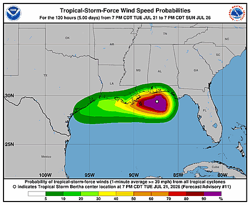

The National Hurricane Center issued its latest forecast discussion for Tropical Storm Bertha late Tuesday evening, painting a picture of a storm battling hostile atmospheric conditions as it pushes westward along the northern Gulf Coast.
As of 10:00 PM CDT Tuesday, July 21, 2026, Bertha was packing maximum sustained winds of 50 knots — roughly 60 miles per hour. Reconnaissance aircraft flying through the storm found that its central pressure had held steady compared to earlier in the day, though forecasters noted that the current intensity rating may be slightly on the generous side.
The storm is dealing with north-northeasterly vertical wind shear, which is causing the storm’s vortex to tilt southward with height. Despite that, Bertha continues to generate strong thunderstorm activity, with extremely cold cloud tops — colder than -70 degrees Celsius — concentrated over its southern half. The low-level center of the storm sits near the northeastern edge of that main area of convection.
Bertha is currently drifting westward at about 5 knots. Forecasters say the storm has been squeezed between two mid-level high pressure systems, but a larger high pressure area sitting over the south-central United States is expected to take over as the primary steering force. That setup should keep Bertha tracking westward near or along the northern Gulf Coast for the next 36 to 48 hours, before the system — if it holds together — pushes into portions of southeastern Texas.
A weakening trend is expected to begin Wednesday, as the storm moves partially over southeastern Louisiana and continues to face strong wind shear and dry air in the mid-levels of the atmosphere. The forecast calls for Bertha to fully dissipate by Saturday, July 25.
Forecasters issued four key messages for residents and interests along the Gulf Coast:
First, tropical storm conditions are expected to spread westward from the Florida Panhandle to southeastern Louisiana, including the greater New Orleans area, through Wednesday night. Tropical storm conditions are also possible along portions of the southwestern Louisiana coast Wednesday night into Thursday.
Second, a Coastal Flood Warning is currently in effect for the Mississippi and Louisiana coastlines, where moderate coastal flooding is anticipated.
Third, people in far western Louisiana and along the Upper Texas Coast are urged to keep a close eye on Bertha’s progress, as additional watches or warnings may be issued for those areas.
Fourth, isolated flash flooding will be possible through Thursday along the Gulf Coast, stretching from the western Florida Panhandle into southern Louisiana.
This forecast was prepared by Forecaster Pasch at the National Hurricane Center in Miami, Florida.