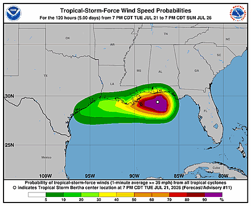

The National Hurricane Center in Miami issued its eleventh wind speed probability update for Tropical Storm Bertha at 11 p.m. Eastern Daylight Time Tuesday, July 21, 2026 — or 3 a.m. Coordinated Universal Time on Wednesday, July 22.
At the time of the advisory, Bertha’s center was located near latitude 29.4 degrees North and longitude 87.7 degrees West, placing the storm in the northern Gulf of Mexico. Maximum sustained winds were clocked at approximately 50 knots — equivalent to 60 miles per hour or 95 kilometers per hour.
The advisory included a detailed wind speed probability table covering dozens of coastal locations over a five-day period. The table shows the likelihood of sustained winds reaching at least 39 mph (tropical storm force), 58 mph, or 74 mph (hurricane force) at each location.
Among the locations with the highest cumulative probabilities of experiencing tropical storm-force winds were areas near the storm’s current position. Buras, Louisiana carried a 46 percent cumulative chance of seeing 39 mph or greater winds through Thursday morning, and a 3 percent chance of reaching 58 mph winds. Houma, Louisiana showed a 22 percent cumulative probability of tropical storm-force winds.
New Orleans, Louisiana had an 11 to 14 percent cumulative chance of tropical storm-force conditions, while Gulfport, Mississippi carried a 6 percent cumulative probability. Baton Rouge, Louisiana showed a 3 percent cumulative chance.
Further west along the Gulf Coast, Galveston, Texas carried an 18 to 21 percent cumulative probability of tropical storm-force winds and a 3 percent cumulative chance of reaching 58 mph. Cameron, Louisiana showed a 20 percent cumulative chance of tropical storm-force conditions.
The advisory was prepared by forecaster Pasch at the National Hurricane Center. Residents along the Gulf Coast are encouraged to monitor future advisories as Bertha’s track and intensity continue to be assessed.