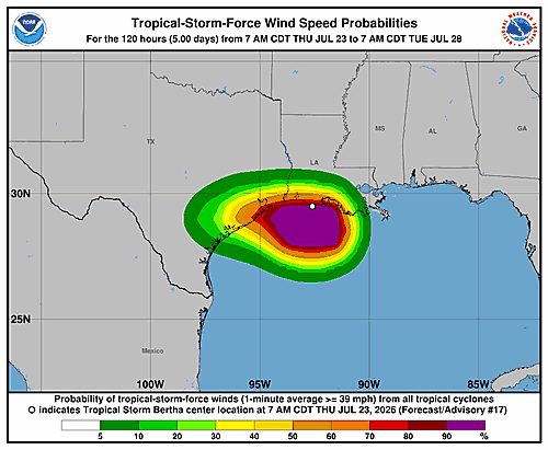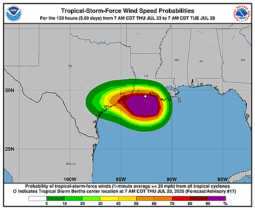

As of 10:00 AM CDT Thursday, July 23, 2026, Tropical Storm Bertha has been tracking along or just off the southwestern Louisiana coastline over the past several hours, according to a forecast discussion issued by the National Hurricane Center in Miami and the NWS Weather Prediction Center in College Park, Maryland.
Data gathered by Air Force Reserve reconnaissance aircraft indicate that Bertha’s circulation has been stretching and becoming increasingly elongated. Forecasters attribute this to a persistent imbalance in the storm’s convective activity. Infrared satellite imagery and radar data show that nearly all of the storm’s active thunderstorm activity is concentrated south of the center, with a large swath of heavy rainfall and embedded thunderstorms already bearing down on the Texas coastline.
The storm’s maximum sustained winds are currently estimated at 40 knots — about 45 miles per hour — though forecasters note those winds are occurring offshore over the southern portion of the circulation.
Bertha’s path over the past 12 hours has been erratic, but when accounting for wobbles and possible center shifts, the storm has been moving westward at approximately 9 knots. Forecasters expect Bertha to accelerate slightly to the west, riding along the southern edge of a mid-level ridge, which should push the storm inland over Texas sometime late Thursday afternoon or evening.
Given the storm’s poor overall structure and anticipated northerly vertical wind shear, little change in intensity is expected before Bertha makes its final landfall. The storm is forecast to weaken into a remnant low or dissipate entirely within roughly 24 hours.
The National Hurricane Center issued the following key messages with this forecast discussion:
1. Tropical storm conditions are expected to spread westward along the northwestern Gulf Coast, from south central Louisiana to the upper Texas coast, throughout Thursday.
2. A Coastal Flood Warning remains in effect for portions of the Mississippi and Louisiana coastlines, where moderate coastal flooding is ongoing.
3. Isolated flash flooding is possible along the Texas Gulf Coast and into South Texas through Thursday night.
Forecast positions show Bertha moving inland near the Texas coast by midnight Thursday night, weakening to a 20-knot post-tropical remnant low by Friday morning, and dissipating entirely by early Saturday. This forecast discussion was prepared by Forecaster Cangialosi.