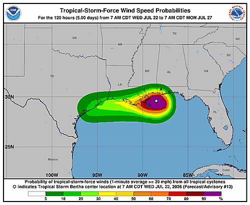

The National Hurricane Center issued its latest update on Tropical Storm Bertha Wednesday morning, painting a picture of a struggling but still dangerous storm moving across the Gulf of Mexico.
According to forecasters, Bertha’s appearance on satellite imagery has continued to deteriorate throughout the morning. Powerful wind shear has pushed the storm’s deep thunderstorm activity far to the southwest of the exposed center of circulation. Despite the weakening appearance, dropsonde data collected by NOAA and Air Force Reserve Hurricane Hunter aircraft show that the storm’s central pressure has barely changed since the previous advisory.
A NOAA aircraft recorded a peak flight-level wind of 55 knots at the 750-millibar level several hours ago, which translates to a current intensity of 45 knots. More recent aircraft readings suggest those winds may have eased somewhat, but forecasters say they are holding the 45-knot estimate while awaiting additional aircraft and scatterometer data expected over the next few hours.
Bertha’s center has been tracking slightly north of the predicted path, with the current motion estimated at 290 degrees at 5 knots — essentially drifting west-northwest at a slow pace. Forecasting models indicate the storm should return to a more westward track during the day Wednesday. The National Hurricane Center notes that these kinds of deviations are typical behavior for a tropical cyclone experiencing heavy wind shear.
Once Bertha resumes a westward motion, the center is expected to hover near the Louisiana coastline through Thursday before pushing into the upper Texas coast Thursday evening or overnight. The NHC’s official track sits along the northern edge of the available model guidance, partly to account for the recent northward drift and partly because reliable forecast models — specifically the HCCA and GDMI — are pointing in that direction.
Forecasters say the storm appears to be on the verge of beginning a weakening trend, and the central question now is how fast that process will unfold. How much time the center spends over land — combined with the ongoing strong northeasterly wind shear — will determine the rate of weakening. The NHC’s intensity forecast keeps Bertha at minimal tropical storm strength through 36 hours, roughly coinciding with a potential Texas landfall, though forecasters acknowledge the storm could drop to a tropical depression or remnant low by that point.
A remnant low is shown in the forecast over Texas at the 48-hour mark, though Bertha could fully dissipate before that time. The 60-hour forecast shows the system no longer exists as an organized storm.
The National Hurricane Center issued three key messages alongside the forecast:
First, tropical storm conditions are expected to continue along parts of the northern Gulf Coast — from the western Florida Panhandle to southeastern Louisiana, including the greater New Orleans area — through Wednesday night. Tropical storm conditions are also possible along the southwestern Louisiana coast and upper Texas coast from tonight through late Thursday.
Second, a Coastal Flood Warning is in effect for the Mississippi and Louisiana coastlines, where moderate coastal flooding is anticipated.
Third, isolated flash flooding remains possible through Friday morning along the central to western Gulf Coast, stretching from Northwest Florida to southern Texas.
The forecast was issued by Forecaster Berg at the National Hurricane Center in Miami.